

The Impacts of Gentrification on Air Pollutant Levels and Child Opportunity Index near New York City Schools

 , ,
, , 
Abstract
1. Introduction
2. Methods
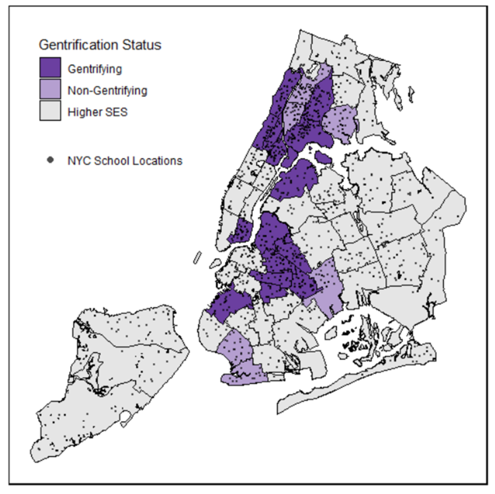
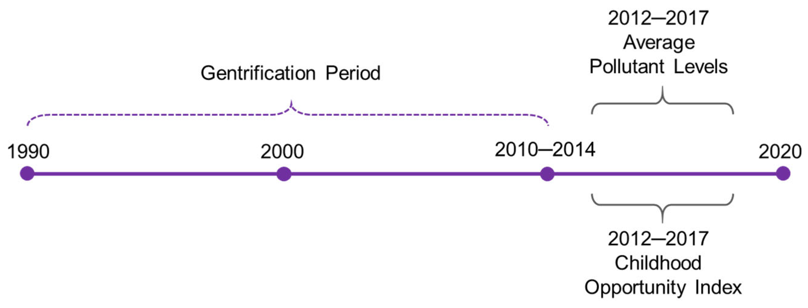
2.1. Study Design
2.2. Estimated Air Pollution Levels Based on Land-Use Regression Modeling
2.3. Child Opportunity Index (COI)
2.4. Data Analyses
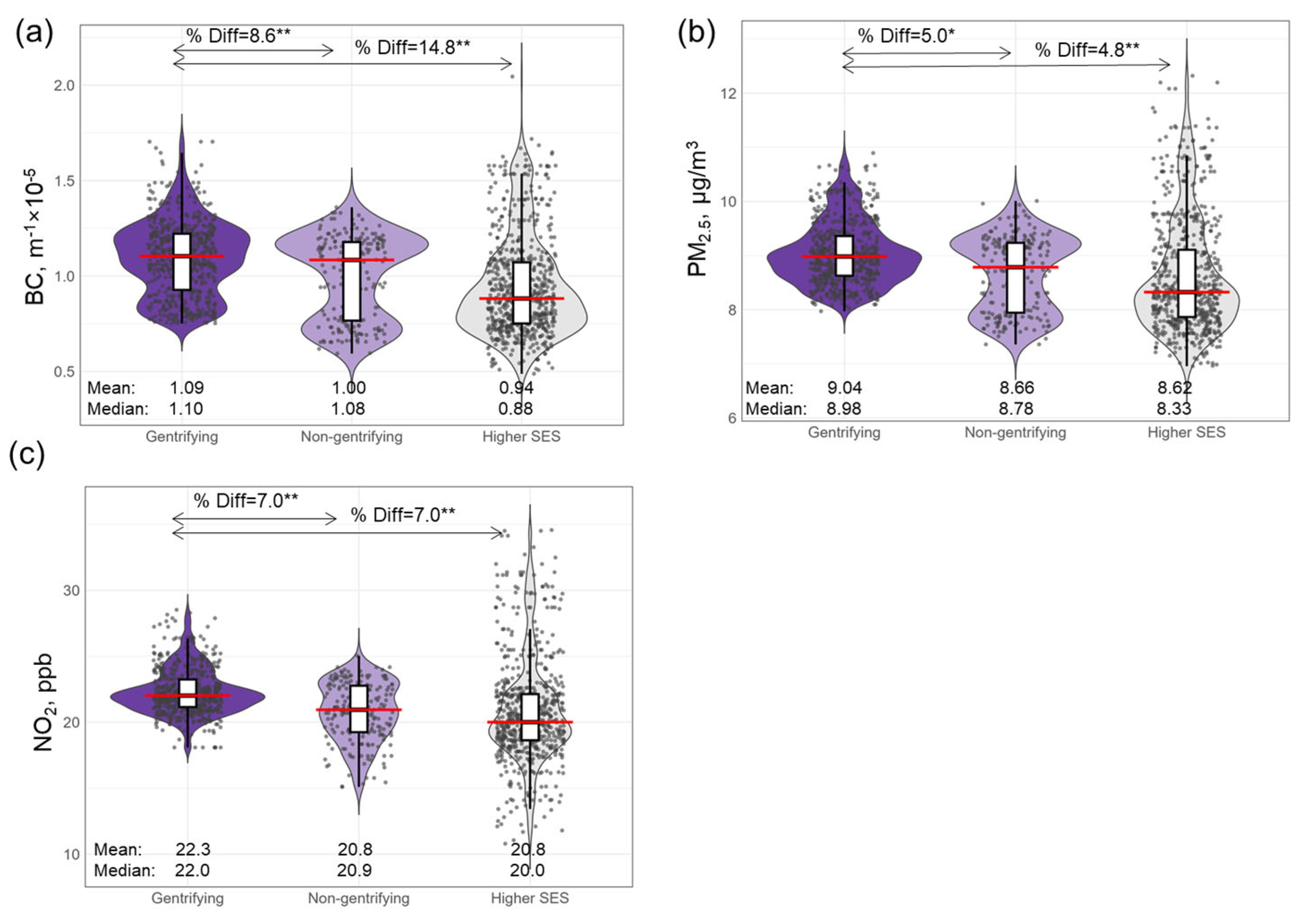
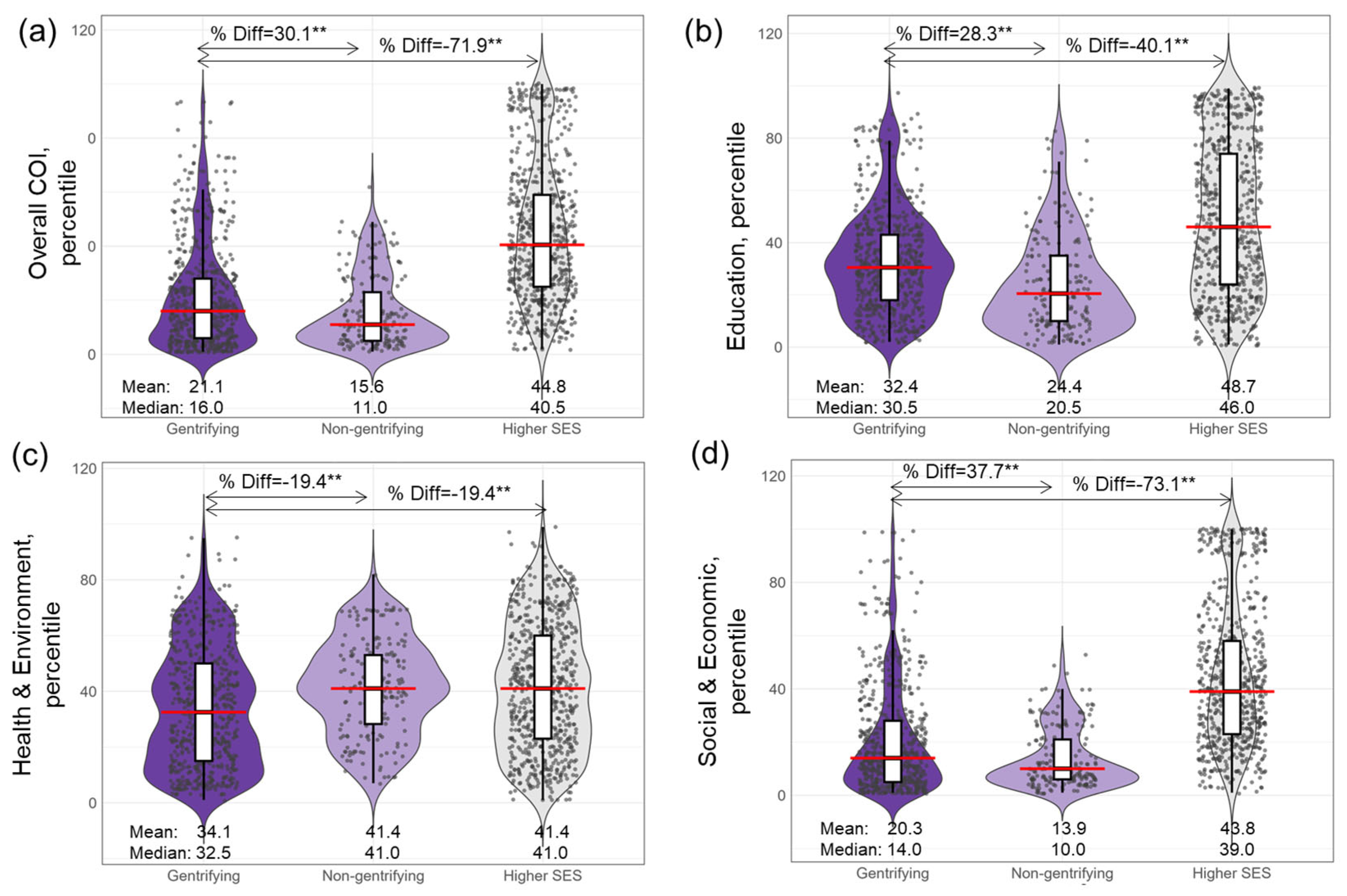
3. Results
4. Discussion
5. Conclusions
Author Contributions
Funding
Data Availability Statement
Conflicts of Interest
References
- Gaffin, J.M.; Petty, C.R.; Hauptman, M.; Kang, C.-M.; Wolfson, J.M.; Abu Awad, Y.; Di, Q.; Lai, P.S.; Sheehan, W.J.; Baxi, S.; et al. Modeling indoor particulate exposures in inner-city school classrooms. J. Expo. Sci. Environ. Epidemiol. 2017, 27, 451–457. [Google Scholar] [CrossRef]
- Kingsley, S.L.; Eliot, M.N.; Carlson, L.; Finn, J.; MacIntosh, D.L.; Suh, H.H.; Wellenius, G. Proximity of us schools to major roadways: A nationwide assessment. J. Expo. Sci. Environ. Epidemiol. 2014, 24, 253–259. [Google Scholar] [CrossRef] [PubMed]
- Permaul, P.; Phipatanakul, W. School environmental intervention programs. J. Allergy Clin. Immunol. Pract. 2018, 6, 22–29. [Google Scholar] [CrossRef]
- Jung, K.H.; Goodwin, K.E.; Perzanowski, M.S.; Chillrud, S.N.; Perera, F.P.; Miller, R.L.; Lovinsky-Desir, S. Personal exposure to black carbon at school and levels of fractional exhaled nitric oxide in new york city. Environ. Health Perspect. 2021, 129, 097005. [Google Scholar] [CrossRef] [PubMed]
- Lane, H.M.; Morello-Frosch, R.; Marshall, J.D.; Apte, J.S. Historical redlining is associated with present-day air pollution disparities in u.S. Cities. Environ. Sci. Technol. Lett. 2022, 9, 345–350. [Google Scholar] [CrossRef] [PubMed]
- Jung, K.H.; Pitkowsky, Z.; Argenio, K.; Quinn, J.W.; Bruzzese, J.-M.; Miller, R.L.; Chillrud, S.N.; Perzanowski, M.; Stingone, J.A.; Lovinsky-Desir, S. The effects of the historical practice of residential redlining in the united states on recent temporal trends of air pollution near new york city schools. Environ. Int. 2022, 169, 107551. [Google Scholar] [CrossRef]
- Jung, K.H.; Argenio, K.L.; Jackson, D.J.; Miller, R.L.; Perzanowski, M.S.; Rundle, A.G.; Bacharier, L.B.; Busse, W.W.; Cohen, R.T.; Visness, C.M.; et al. Home and school pollutant exposure, respiratory outcomes, and influence of historical redlining. J. Allergy Clin. Immunol. 2024, 154, 1159–1168. [Google Scholar] [CrossRef]
- Clark, L.P.; Millet, D.B.; Marshall, J.D. Changes in transportation-related air pollution exposures by race-ethnicity and socioeconomic status: Outdoor nitrogen dioxide in the united states in 2000 and 2010. Environ. Health Perspect. 2017, 125, 097012. [Google Scholar] [CrossRef]
- Gray, S.C.; Edwards, S.E.; Miranda, M.L. Race, socioeconomic status, and air pollution exposure in north carolina. Environ. Res. 2013, 126, 152–158. [Google Scholar] [CrossRef]
- Tessum, C.W.; Paolella, D.A.; Chambliss, S.E.; Apte, J.S.; Hill, J.D.; Marshall, J.D. Pm2.5 polluters disproportionately and systemically affect people of color in the united states. Sci. Adv. 2021, 7, eabf4491. [Google Scholar] [CrossRef]
- McKinnish, T.; Walsh, R.; White, T.K. Who gentrifies low-income neighborhoods? J. Urban Econ. 2010, 67, 180–193. [Google Scholar] [CrossRef] [PubMed]
- Bradley, A.C.; Croes, B.E.; Harkins, C.; McDonald, B.C.; de Gouw, J.A. Air pollution inequality in the denver metroplex and its relationship to historical redlining. Environ. Sci. Technol. 2024, 58, 4226–4236. [Google Scholar] [CrossRef] [PubMed]
- Garg, A.; Sochet, A.A.; Hernandez, R.; Stockwell, D.C. Association of the child opportunity index and inpatient illness severity in the united states, 2018–2019. Acad. Pediatr. 2024, 24, 1101–1109. [Google Scholar] [CrossRef]
- Maholtz, D.; Page-Goertz, C.K.; Forbes, M.L.; Nofziger, R.A.; Bigham, M.; McKee, B.; Ramgopal, S.; Pelletier, J.H. Association between the coi and excess health care utilization and costs for acsc. Hosp. Pediatr. 2024, 14, 592–601. [Google Scholar] [CrossRef]
- OpenData, N. 2018–2019 School Locations. Available online: https://data.cityofnewyork.us/Education/2018-2019-School-Locations/9ck8-hj3u/data_preview (accessed on 1 July 2021).
- NYU Furman Center AoO, 2021. State of New York City’s Housing and Neighborhoods in 2015. 2015. Available online: https://furmancenter.org/files/sotc/NYUFurmanCenter_SOCin2015_9JUNE2016.pdf (accessed on 6 January 2022).
- Matte, T.D.; Ross, Z.; Kheirbek, I.; Eisl, H.; Johnson, S.; Gorczynski, J.E.; Kass, D.; Markowitz, S.; Pezeshki, G.; E Clougherty, J. Monitoring intraurban spatial patterns of multiple combustion air pollutants in new york city: Design and implementation. J. Expo. Sci. Environ. Epidemiol. 2013, 23, 223–231. [Google Scholar] [CrossRef]
- Clougherty, J.E.; Kheirbek, I.; Eisl, H.M.; Ross, Z.; Pezeshki, G.; Gorczynski, J.E.; Johnson, S.C.; Markowitz, S.; Kass, D.; Matte, T.D. Intra-urban spatial variability in wintertime street-level concentrations of multiple combustion-related air pollutants: The new york city community air survey (nyccas). J. Expo. Sci. Environ. Epidemiol. 2013, 23, 232–240. [Google Scholar] [CrossRef] [PubMed]
- Kheirbek, I.; Ito, K.; Neitzel, R.; Kim, J.; Johnson, S.; Ross, Z.; Eisl, H.; Matte, T. Spatial variation in environmental noise and air pollution in new york city. J. Urban Health 2014, 91, 415–431. [Google Scholar] [CrossRef]
- OpenData, N. 2022. Available online: https://data.cityofnewyork.us/Environment/NYCCAS-Air-Pollution-Rasters/q68s-8qxv/about_data (accessed on 6 January 2022).
- Noelke, C.; McArdle, N.; Baek, M.; Huntington, N.; Huber, R.; Hardy, E.; Acevedo-Garcia, D. Child Opportunity Index 2.0. 2020. Available online: https://www.diversitydatakids.org/research-library/research-brief/how-we-built-it (accessed on 6 January 2022).
- Dragan, K.; Ellen, I.; Glied, S.A. Does Gentrification Displace Poor Children? New Evidence from New York City Medicaid Data; National Bureau of Economic Research: Cambridge, MA, USA, 2019. [Google Scholar]
- Hutchings, H.; Zhang, Q.; Grady, S.; Mabe, L.; Okereke, I.C. Gentrification and air quality in a large urban county in the united states. Int. J. Environ. Res. Public Health 2023, 20, 4762. [Google Scholar] [CrossRef]
- Nardone, A.; Casey, J.A.; Morello-Frosch, R.; Mujahid, M.; Balmes, J.R.; Thakur, N. Associations between historical residential redlining and current age-adjusted rates of emergency department visits due to asthma across eight cities in california: An ecological study. Lancet Planet. Health 2020, 4, e24–e31. [Google Scholar] [CrossRef]
- Azarmi, F.; Kumar, P. Ambient exposure to coarse and fine particle emissions from building demolition. Atmos. Environ. 2016, 137, 62–79. [Google Scholar] [CrossRef]
- Yan, H.; Li, Q.; Feng, K.; Zhang, L. The characteristics of pm emissions from construction sites during the earthwork and foundation stages: An empirical study evidence. Environ. Sci. Pollut. Res. 2023, 30, 62716–62732. [Google Scholar] [CrossRef] [PubMed]
- Rao, M.; George, L.A.; Rosenstiel, T.N.; Shandas, V.; Dinno, A. Assessing the relationship among urban trees, nitrogen dioxide, and respiratory health. Environ. Pollut. 2014, 194, 96–104. [Google Scholar] [CrossRef] [PubMed]
- Zupancic, T.; Westmacott, C.; Bulthuis, M. The Impact of Green Space on Heat and Air Pollution in Urban Communities: A Meta-narrative Systematic Review; David Suzuki Foundation: Vancouver, BC, Canada, 2015. [Google Scholar]
- Rahaman, S.N.; Ahmed, S.M.; Zeyad, M.; Zim, A.H. Effect of vegetation and land surface temperature on no2 concentration: A google earth engine-based remote sensing approach. Urban Clim. 2023, 47, 101336. [Google Scholar] [CrossRef]
- Lovasi, G.S.; O’Neil-Dunne, J.P.; Lu, J.W.; Sheehan, D.; Perzanowski, M.S.; MacFaden, S.W.; King, K.L.; Matte, T.; Miller, R.L.; Hoepner, L.A.; et al. Urban tree canopy and asthma, wheeze, rhinitis, and allergic sensitization to tree pollen in a new york city birth cohort. Environ. Health Perspect. 2013, 121, 494–500. [Google Scholar] [CrossRef]
- Jelks, N.T.O.; Jennings, V.; Rigolon, A. Green gentrification and health: A scoping review. Int. J. Environ. Res. Public Health 2021, 18, 907. [Google Scholar] [CrossRef]
- Jung, K.H.; Liu, B.; Lovinsky-Desir, S.; Yan, B.; Camann, D.; Sjodin, A.; Li, Z.; Perera, F.; Kinney, P.; Chillrud, S.; et al. Time trends of polycyclic aromatic hydrocarbon exposure in new york city from 2001 to 2012: Assessed by repeat air and urine samples. Environ. Res. 2014, 131, 95–103. [Google Scholar] [CrossRef]
- Narvaez, R.F.; Hoepner, L.; Chillrud, S.N.; Yan, B.; Garfinkel, R.; Whyatt, R.; Camann, D.; Perera, F.P.; Kinney, P.L.; Miller, R.L. Spatial and temporal trends of polycyclic aromatic hydrocarbons and other traffic-related airborne pollutants in new york city. Environ. Sci. Technol. 2008, 42, 7330–7335. [Google Scholar] [CrossRef]
- Stehlin, J. Cycles of investment: Bicycle infrastructure, gentrification, and the restructuring of the san francisco bay area. Environ. Plan. A 2015, 47, 121–137. [Google Scholar] [CrossRef]
Disclaimer/Publisher’s Note: The statements, opinions and data contained in all publications are solely those of the individual author(s) and contributor(s) and not of MDPI and/or the editor(s). MDPI and/or the editor(s) disclaim responsibility for any injury to people or property resulting from any ideas, methods, instructions or products referred to in the content. |
© 2025 by the authors. Licensee MDPI, Basel, Switzerland. This article is an open access article distributed under the terms and conditions of the Creative Commons Attribution (CC BY) license (https://creativecommons.org/licenses/by/4.0/).
Share and Cite
Jung, K.H.; Pitkowsky, Z.; Argenio, K.L.; Quinn, J.W.; Stingone, J.A.; Rundle, A.G.; Bruzzese, J.-M.; Chillrud, S.; Perzanowski, M.; Lovinsky-Desir, S. The Impacts of Gentrification on Air Pollutant Levels and Child Opportunity Index near New York City Schools. Environments 2025, 12, 199. https://doi.org/10.3390/environments12060199
Jung KH, Pitkowsky Z, Argenio KL, Quinn JW, Stingone JA, Rundle AG, Bruzzese J-M, Chillrud S, Perzanowski M, Lovinsky-Desir S. The Impacts of Gentrification on Air Pollutant Levels and Child Opportunity Index near New York City Schools. Environments. 2025; 12(6):199. https://doi.org/10.3390/environments12060199
Chicago/Turabian StyleJung, Kyung Hwa, Zachary Pitkowsky, Kira L. Argenio, James W. Quinn, Jeanette A. Stingone, Andrew G. Rundle, Jean-Marie Bruzzese, Steven Chillrud, Matthew Perzanowski, and Stephanie Lovinsky-Desir. 2025. "The Impacts of Gentrification on Air Pollutant Levels and Child Opportunity Index near New York City Schools" Environments 12, no. 6: 199. https://doi.org/10.3390/environments12060199
APA StyleJung, K. H., Pitkowsky, Z., Argenio, K. L., Quinn, J. W., Stingone, J. A., Rundle, A. G., Bruzzese, J.-M., Chillrud, S., Perzanowski, M., & Lovinsky-Desir, S. (2025). The Impacts of Gentrification on Air Pollutant Levels and Child Opportunity Index near New York City Schools. Environments, 12(6), 199. https://doi.org/10.3390/environments12060199