

Aerial Imagery and Surface Water and Ocean Topography for High-Resolution Mapping for Water Availability Assessments of Small Waterbodies on the Coast


Abstract
1. Introduction
2. Study Area and Methods
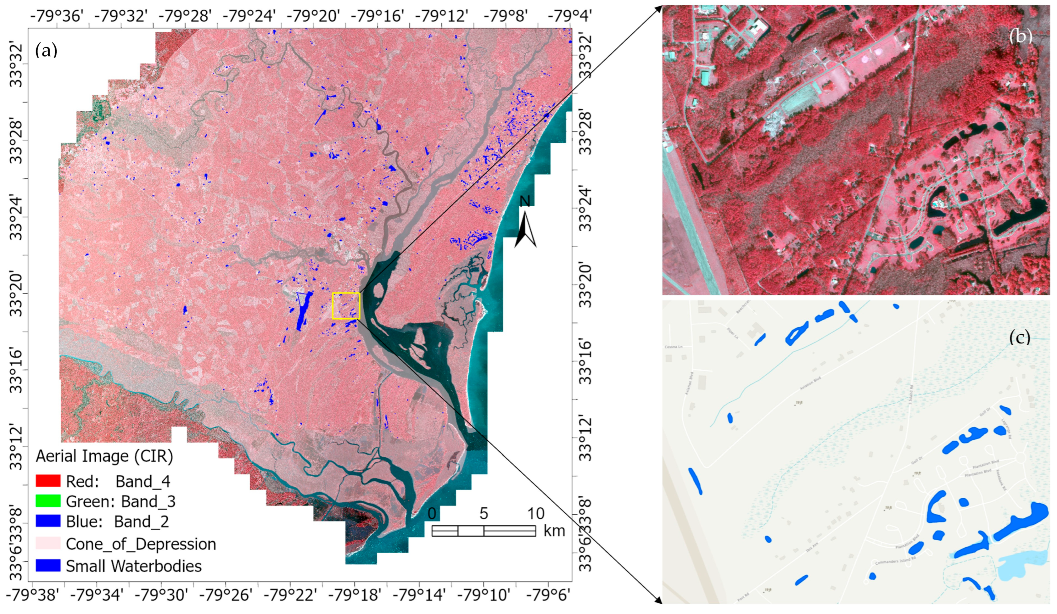
2.1. Study Area and Datasets
2.2. Approaches
2.2.1. Deep Learning of the 15 cm Aerial Imagery for Waterbody Classification
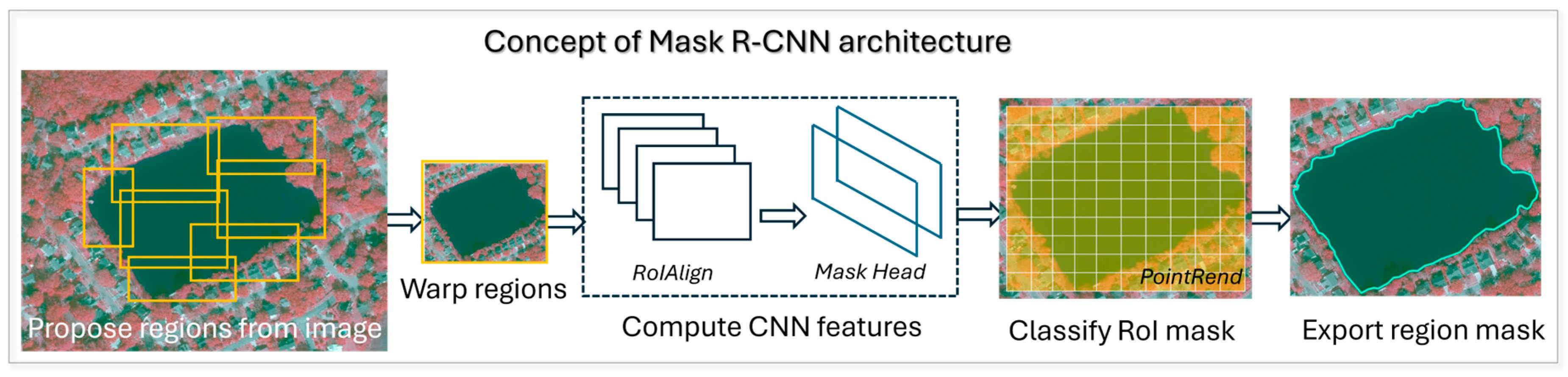
2.2.2. Mask R-CNN Framework
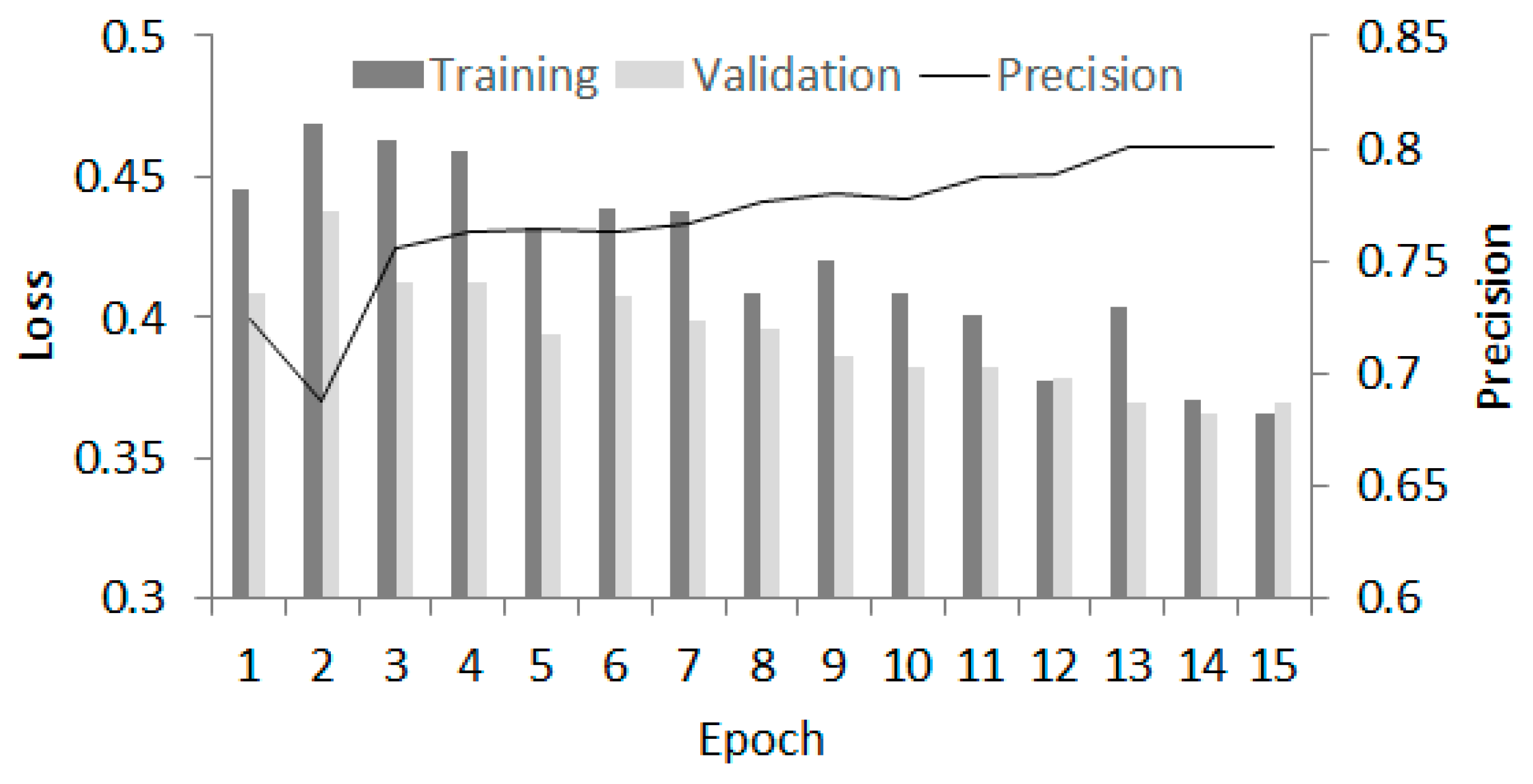
2.2.3. Model Training and Evaluation
2.2.4. SWOT Data Process to Extract the Water Surface Elevation
2.2.5. Extracting WSE from SWOT PIXC
2.2.6. WSE Noise Reduction
2.2.7. Exploring WSE Spatial Patterns Indicating Freshwater Availability
3. Results and Discussion
3.1. Waterbody Classification Via Deep Learning
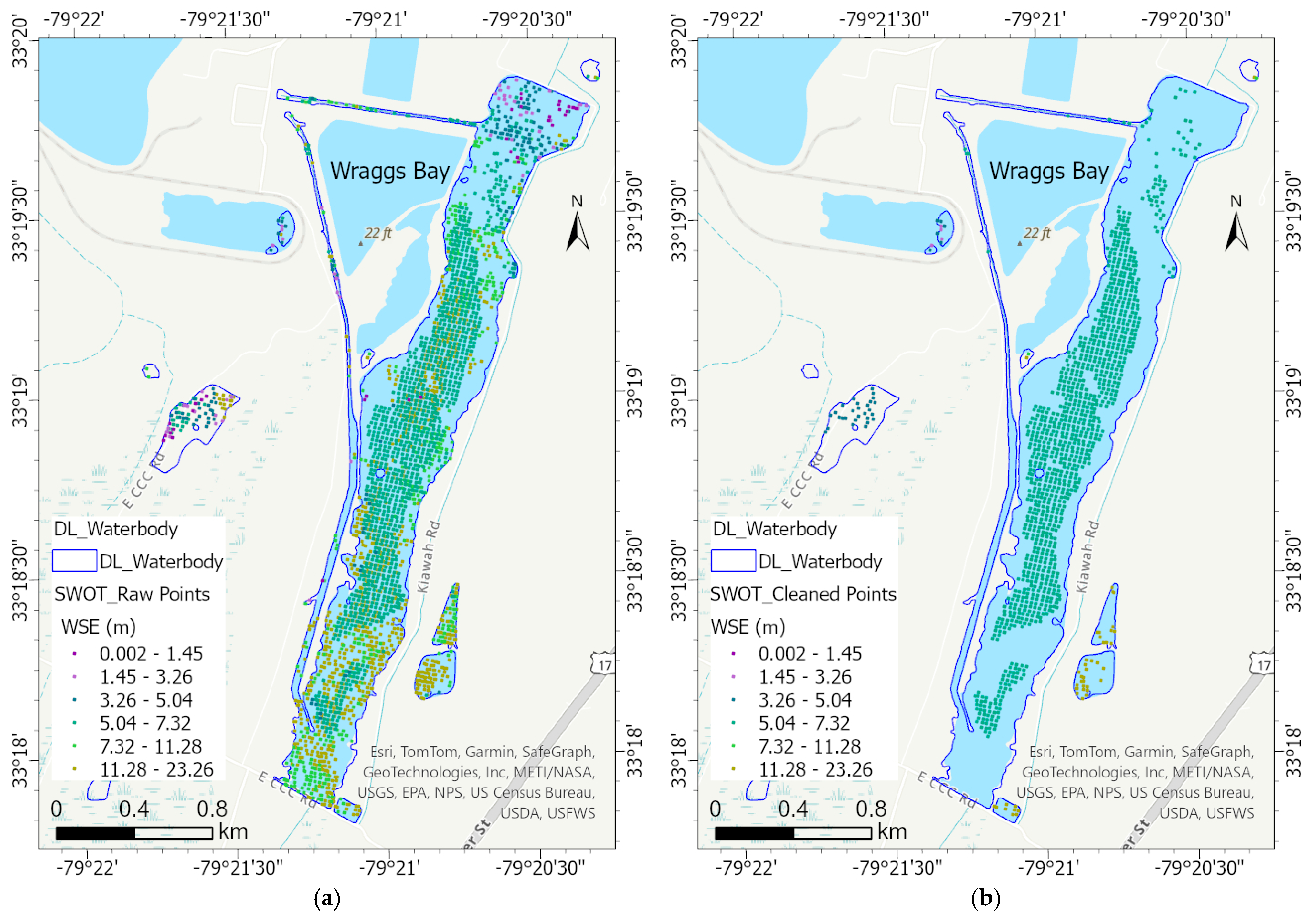
3.2. WSE Extraction from SWOT Pixel Cloud
3.3. WSE Spatial Patterns at Cone of Depression
3.4. SWOT Point Cloud—Limitations and Research Advances
4. Conclusions
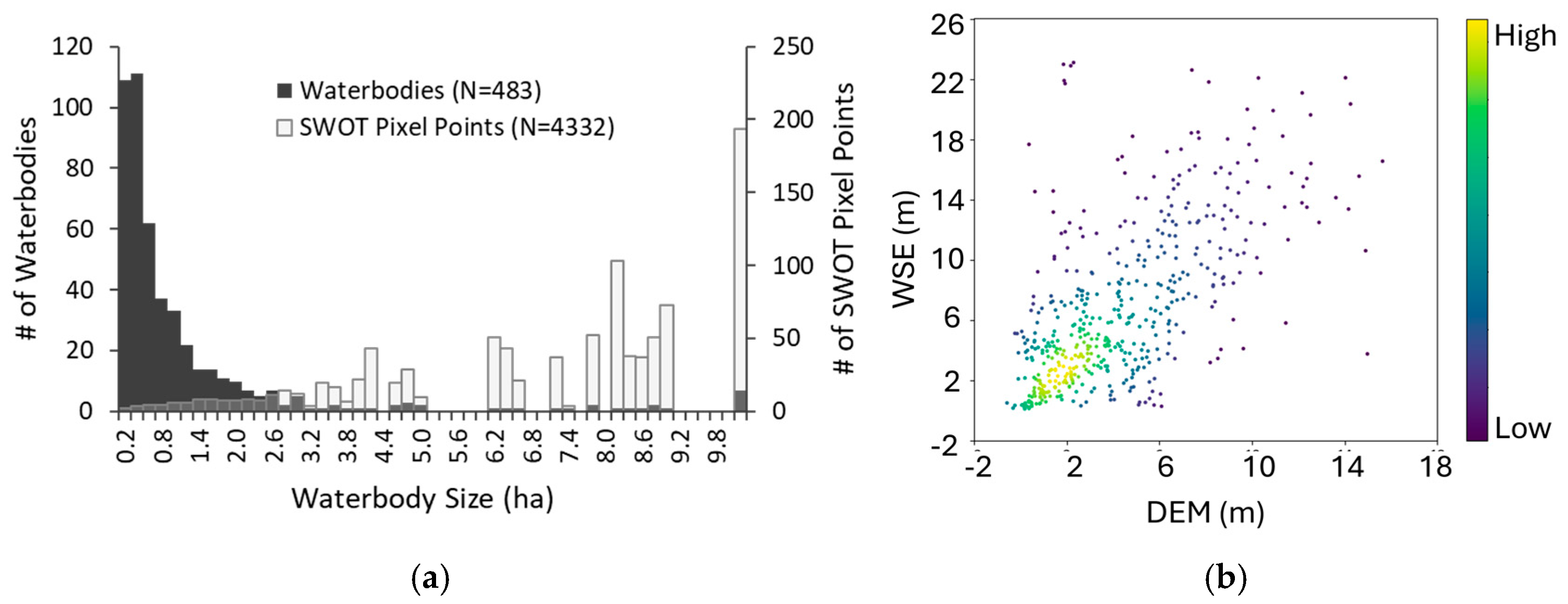
- A total of 1112 small waterbodies were detected using the Mask R-CNN model, with an average precision of 0.81. The smallest waterbody had a size of 0.02 ha.
- The SWOT PIXC pixel points in small waterbodies are noisy in nature. After noise removal, only 483 of the 1112 waterbodies contained valid pixel points, varying from 2 points per waterbody in the smallest sizes and 193.6 points per waterbody in sizes > 10 ha.
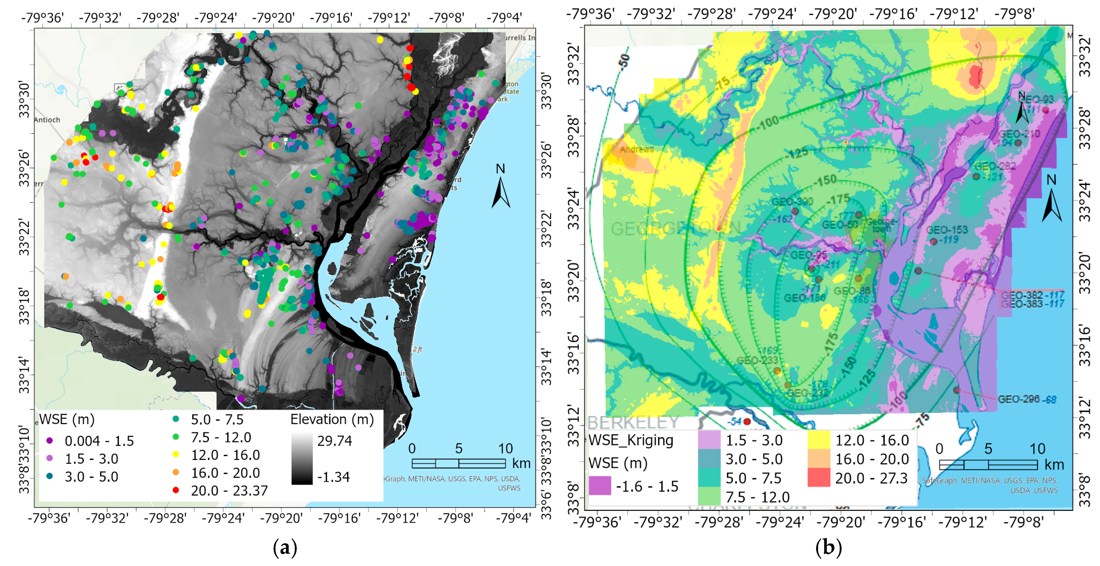
- The surface water levels of small waterbodies are significantly related to elevations across the study area (Pearson’s r = 0.62). The spatially interpolated WSE patterns generally agree with the groundwater contours in the central Cone of Depression but not along the oceanfront, increasing hydro-modeling interest in better understanding this phenomenon.
Author Contributions
Funding
Data Availability Statement
Conflicts of Interest
References
- Hill, M.J.; Greaves, H.M.; Sayer, C.D.; Hassall, C.; Milin, M.; Milner, V.S.; Marazzi, L.; Hall, R.; Harper, L.R.; Thornhill, I.; et al. Pond ecology and conservation: Research priorities and knowledge gaps. Ecosphere 2021, 12, e03853. [Google Scholar] [CrossRef]
- Biggs, J.; von Fumetti, S.; Kelly-Quinn, M. The Importance of Small Waterbodies for Biodiversity and Ecosystem Services: Implications for Policy Makers. Hydrobiologia 2017, 709, 3–19. [Google Scholar] [CrossRef]
- Moore, R.B.; McKay, L.D.; Rea, A.H.; Bondelid, T.R.; Price, C.V.; Dewald, T.G.; Johnston, C.M. User’s Guide for the National Hydrography Dataset Plus (NHDPlus) High Resolution; U.S. Geological Survey Open-File Report 2019–1096; USGS: Reston, VA, USA, 2019; 66p. [CrossRef]
- South Carolina Department of Natural Resources (SCDNR). South Carolina LiDAR Data. 2024. Available online: https://www.dnr.sc.gov/GIS/lidar.html (accessed on 29 December 2024).
- SC Water Resources Center (SCWRC). Inventory of Lakes in South Carolina: Ten Acres or More in Surface Area; SCWRC Report 171; U.S. Army Corps of Engineers: Columbia, SC, USA, 1991.
- Qayyum, N.; Ghuffar, S.; Ahmad, H.; Yousaf, A.; Shahid, I. Glacial lakes mapping using multi satellite PlanetScope imagery and deep learning. ISPRS Int. J. Geo-Inf. 2020, 9, 560. [Google Scholar] [CrossRef]
- Mullen, A.L.; Watts, J.D.; Rogers, B.M.; Carroll, M.L.; Elder, C.D.; Noomah, J.; Williams, Z.; Caraballo-Vega, J.A.; Bredder, A.; Rickenbaugh, E. Using high-resolution satellite imagery and deep learning to track dynamic seasonality in small water bodies. Geophys. Res. Lett. 2023, 50, e2022GL102327. [Google Scholar] [CrossRef]
- Sun, D.; Gao, G.; Huang, L.; Liu, Y. Extraction of Water Bodies from High-resolution Remote Sensing Imagery Based on a Deep Semantic Segmentation Network. Sci. Rep. 2024, 14, 14604. [Google Scholar] [CrossRef] [PubMed]
- SC Revenue and Fiscal Affairs Office (SCRFA). SC Aerial Imagery Program. 2024. Available online: https://rfa.sc.gov/programs-services/geodetic/statewide-aerial-imagery (accessed on 29 December 2024).
- Ren, S.; He, K.; Girshick, R.; Sun, J. Faster R-CNN: Towards Real-Time Object Detection with Region Proposal Networks. IEEE Trans. Pattern Anal. Mach. Intell. 2017, 39, 1137–1149. [Google Scholar] [CrossRef] [PubMed]
- Fu, L.L.; Pavelsky, T.; Cretaux, J.F.; Morrow, R.; Farrar, J.T.; Vaze, P.; Sengenes, P.; Vinogradova-Shiffer, N.; Sylvestre-Baron, A.; Picot, N.; et al. The surface water and ocean topography Mission: A breakthrough in radar remote sensing of the ocean and land surface water. Geophys. Res. Lett. 2024, 51, e2023GL107652. [Google Scholar] [CrossRef]
- Surface Water Ocean Topography (SWOT). SWOT Science Data Products User Handbook (JPL D-109532); NASA Jet Propulsion Laboratory (JPL): Pasadena, CA, USA, 2024. Available online: https://podaac.jpl.nasa.gov (accessed on 29 December 2024).
- Maubant, L.; Dodd, L.; Tregoning, P. Assessing the accuracy of SWOT measurements of water bodies in Australia. Geophys. Res. Lett. 2025, 52, e2024GL114084. [Google Scholar] [CrossRef]
- Yao, J.; Xu, N.; Wang, M.; Liu, T.; Lu, H.; Cao, Y.; Tang, X.; Mo, F.; Chang, H.; Gong, H.; et al. SWOT satellite for global hydrological applications: Accuracy assessment and insights into surface water dynamics. Int. J. Digit. Earth 2025, 18, 2472924. [Google Scholar] [CrossRef]
- Yu, L.; Zhang, H.; Gong, W.; Ma, X. Validation of Mainland Water Level Elevation Products from SWOT Satellite. IEEE J. Sel. Top. Appl. Earth Obs. Remote Sens. 2024, 17, 13494–13505. [Google Scholar] [CrossRef]
- Zhao, Y.; Fu, J.; Pang, Z.; Jiang, W.; Zhang, P.; Qi, Z. Validation of Inland Water Surface Elevation from SWOT Satellite Products: A Case Study in the Middle and Lower Reaches of the Yangtze River. Remote Sens. 2025, 17, 1330. [Google Scholar] [CrossRef]
- Surface Water Ocean Topography (SWOT). SWOT Product Description—Level 2 KaRIn High Rate Water Mask Pixel Cloud Product, REVISION C (JPL D-56411); NASA Jet Propulsion Laboratory (JPL): Pasadena, CA, USA, 2024. Available online: https://podaac.jpl.nasa.gov/dataset/SWOT_L2_HR_PIXC_2.0 (accessed on 29 December 2024).
- Campbell, B.G.; Fine, J.M.; Petkewich, M.D.; Coes, A.L.; Terziotti, S. Chapter A: Groundwater Availability in the Atlantic Coastal Plain of North and South Carolina. In Groundwater Availability in the Atlantic Coastal Plain of North and South Carolina; Campbell, B.G., Coes, A.L., Eds.; Professional Paper 1773; USGS: Reston, VA, USA, 2010; p. 2. [Google Scholar]
- Kemmer, C.; Wyant, P.; Hughes, J.; Koon, J.M.; Monroe, L.A. Waccamaw Capacity Use Area Groundwater Evaluation Report, Permitting Year 2024; Technical report Number 006-2023; South Carolina Department of Health and Environmental Control (DHEC): Columbia, SC, USA, 2023.
- Gellici, J.A.; Lautier, J.C. Chapter B: Hydrogeologic Framework of the Atlantic Coastal Plain, North and South Carolina. In Groundwater Availability in the Atlantic Coastal Plain of North and South Carolina; Campbell, B.G., Coes, A.L., Eds.; Professional Paper 1773; USGS: Reston, VA, USA, 2010; p. 241. [Google Scholar]
- National Oceanic and Atmospheric Administration (NOAA). Coastal Change Analysis Program (C-CAP) High-Resolution Land Cover; NOAA Office for Coastal Management: Charleston, SC, USA, 2021. Available online: https://coast.noaa.gov/digitalcoast/data/ccaphighres.html (accessed on 29 December 2024).
- U.S. Geological Survey (USGS). USGS 3D Elevation Program Digital Elevation Model. 2019. Available online: https://apps.nationalmap.gov/downloader/ (accessed on 29 December 2024).
- Kirillov, A.; Wu, Y.; He, K.; Girshick, R. PointRend: Image Segmentation as Rendering. arXiv 2019, arXiv:1912.08193. [Google Scholar]
- Pavlis, N.K.; Holmes, S.A.; Kenyon, S.C.; Factor, J.K. The development and evaluation of the Earth Gravity Model 2008 (EGM2008). J. Geophys. Res. Solid Earth 2022, 117, 1978–2012. [Google Scholar]
- Krivoruchko, K.; Gribov, A. Evaluation of empirical Bayesian kriging. Spat. Stat. 2019, 32, 100368. [Google Scholar] [CrossRef]
- White, S.A.; Beecher, L.; Davis, R.H.; Nix, H.B.; Sahoo, D.; Scaroni, A.E.; Wallover, C.G. Ponds in South Carolina. Land-Grant Press by Clemson Extension. 2021. Available online: https://lgpress.clemson.edu/publication/ponds-in-south-carolina/ (accessed on 31 March 2025).
- Salameh, E.; Desroches, D.; Deloffre, J.; Fjørtoft, R.; Mendoza, E.T.; Turki, I.; Froideval, L.; Levaillant, R.; Déchampt, S.; Picot, N.; et al. Evaluating SWOT’s interferometric capabilities for mapping intertidal topography. Remote Sens. Environ. 2024, 314, 114401. [Google Scholar] [CrossRef]
- Schwatke, C.; Dettmering, D.; Seitz, F. Volume Variations of Small Inland Waterbodies from a Combination of Satellite Altimetry and Optical Imagery. Remote Sens. 2020, 12, 1606. [Google Scholar] [CrossRef]

Disclaimer/Publisher’s Note: The statements, opinions and data contained in all publications are solely those of the individual author(s) and contributor(s) and not of MDPI and/or the editor(s). MDPI and/or the editor(s) disclaim responsibility for any injury to people or property resulting from any ideas, methods, instructions or products referred to in the content. |
© 2025 by the authors. Licensee MDPI, Basel, Switzerland. This article is an open access article distributed under the terms and conditions of the Creative Commons Attribution (CC BY) license (https://creativecommons.org/licenses/by/4.0/).
Share and Cite
Wang, C.; Pellett, C.A.; Tan, H.; Arrington, T. Aerial Imagery and Surface Water and Ocean Topography for High-Resolution Mapping for Water Availability Assessments of Small Waterbodies on the Coast. Environments 2025, 12, 168. https://doi.org/10.3390/environments12050168
Wang C, Pellett CA, Tan H, Arrington T. Aerial Imagery and Surface Water and Ocean Topography for High-Resolution Mapping for Water Availability Assessments of Small Waterbodies on the Coast. Environments. 2025; 12(5):168. https://doi.org/10.3390/environments12050168
Chicago/Turabian StyleWang, Cuizhen, Charles Alex Pellett, Haofeng Tan, and Tanner Arrington. 2025. "Aerial Imagery and Surface Water and Ocean Topography for High-Resolution Mapping for Water Availability Assessments of Small Waterbodies on the Coast" Environments 12, no. 5: 168. https://doi.org/10.3390/environments12050168
APA StyleWang, C., Pellett, C. A., Tan, H., & Arrington, T. (2025). Aerial Imagery and Surface Water and Ocean Topography for High-Resolution Mapping for Water Availability Assessments of Small Waterbodies on the Coast. Environments, 12(5), 168. https://doi.org/10.3390/environments12050168