Subsoil Characterisation in an Abandoned Dam in Central Mexico Using Geoelectrical Methods

 , , ,
, , ,
Abstract
1. Introduction
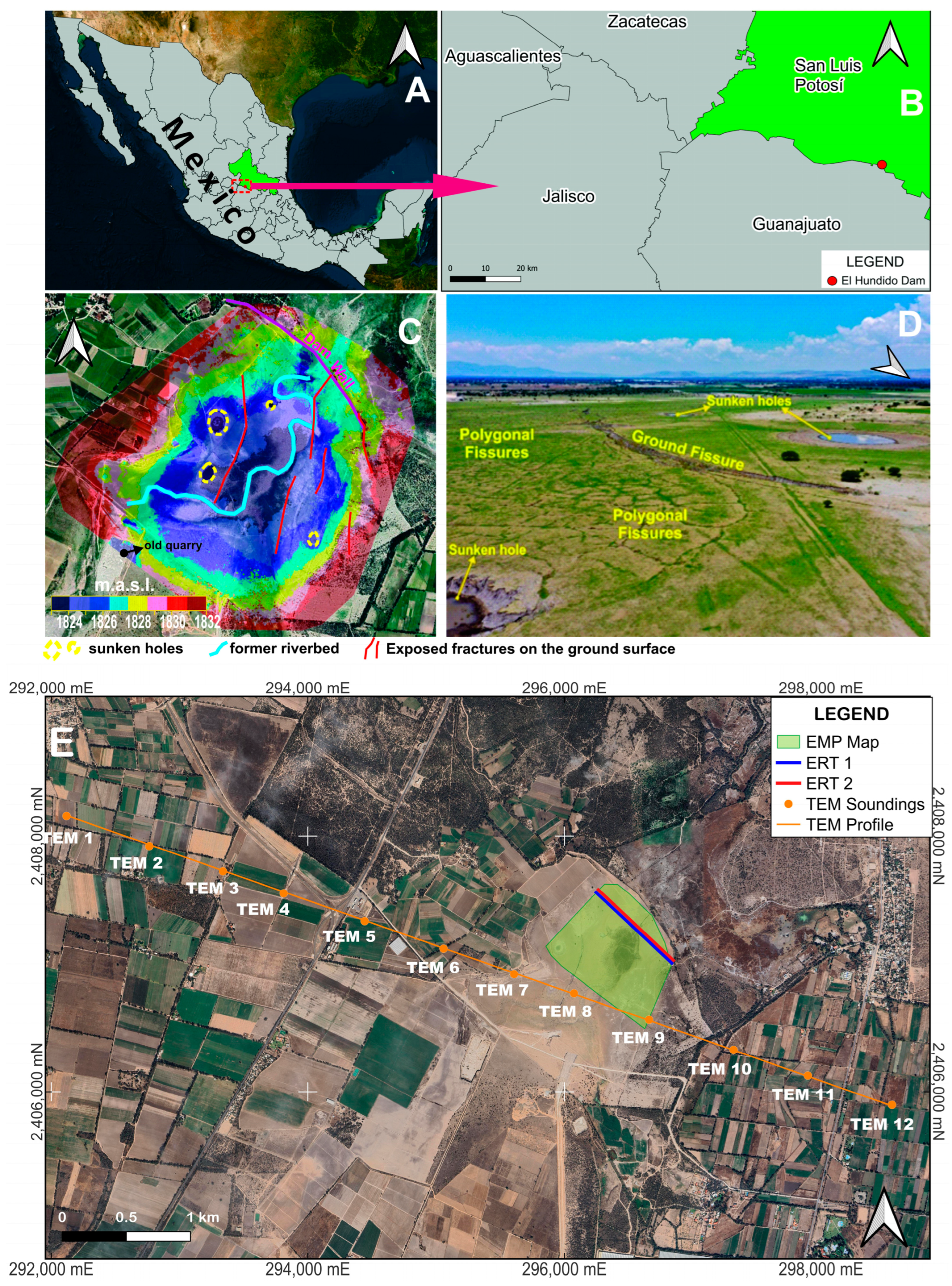
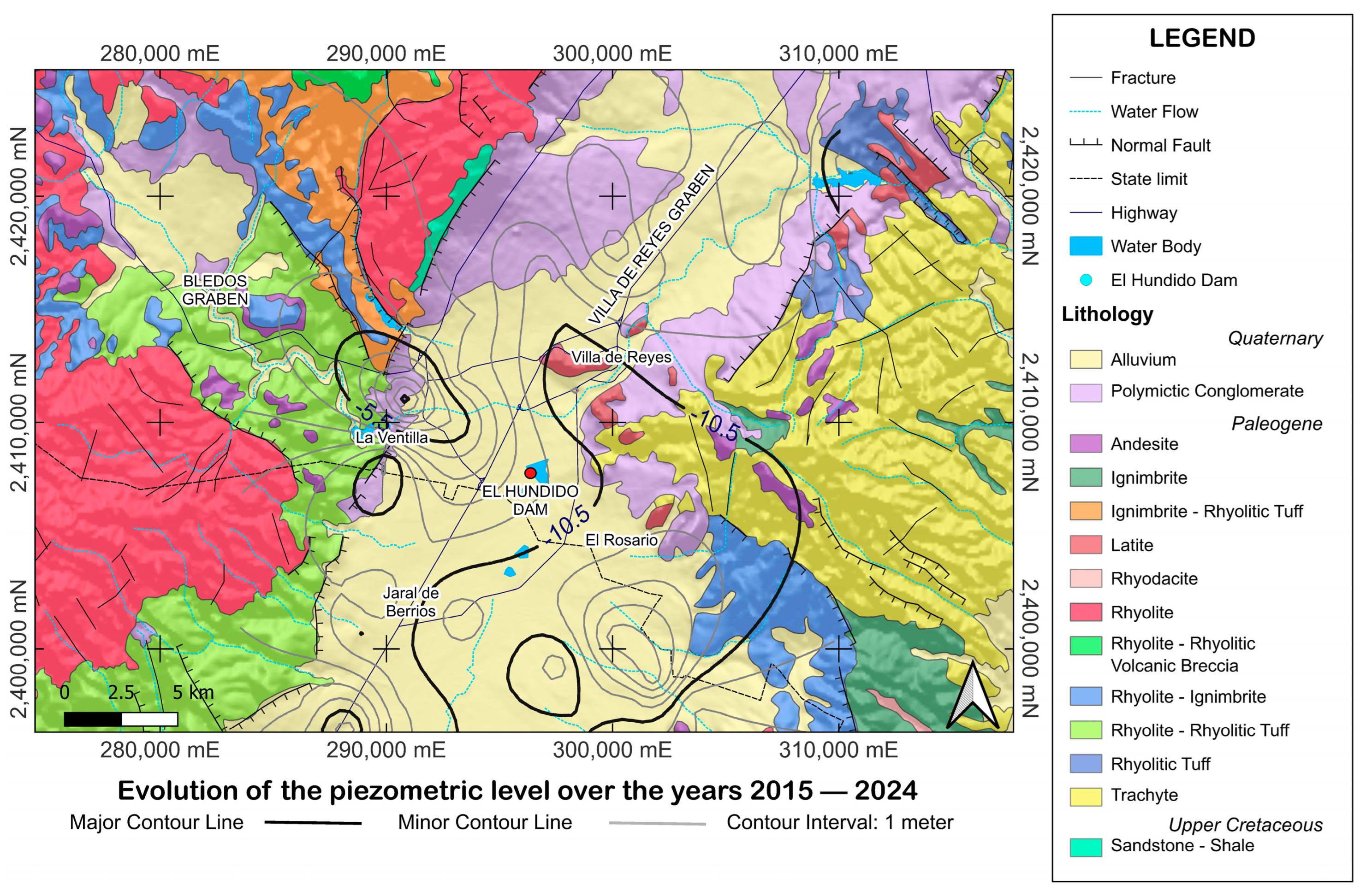
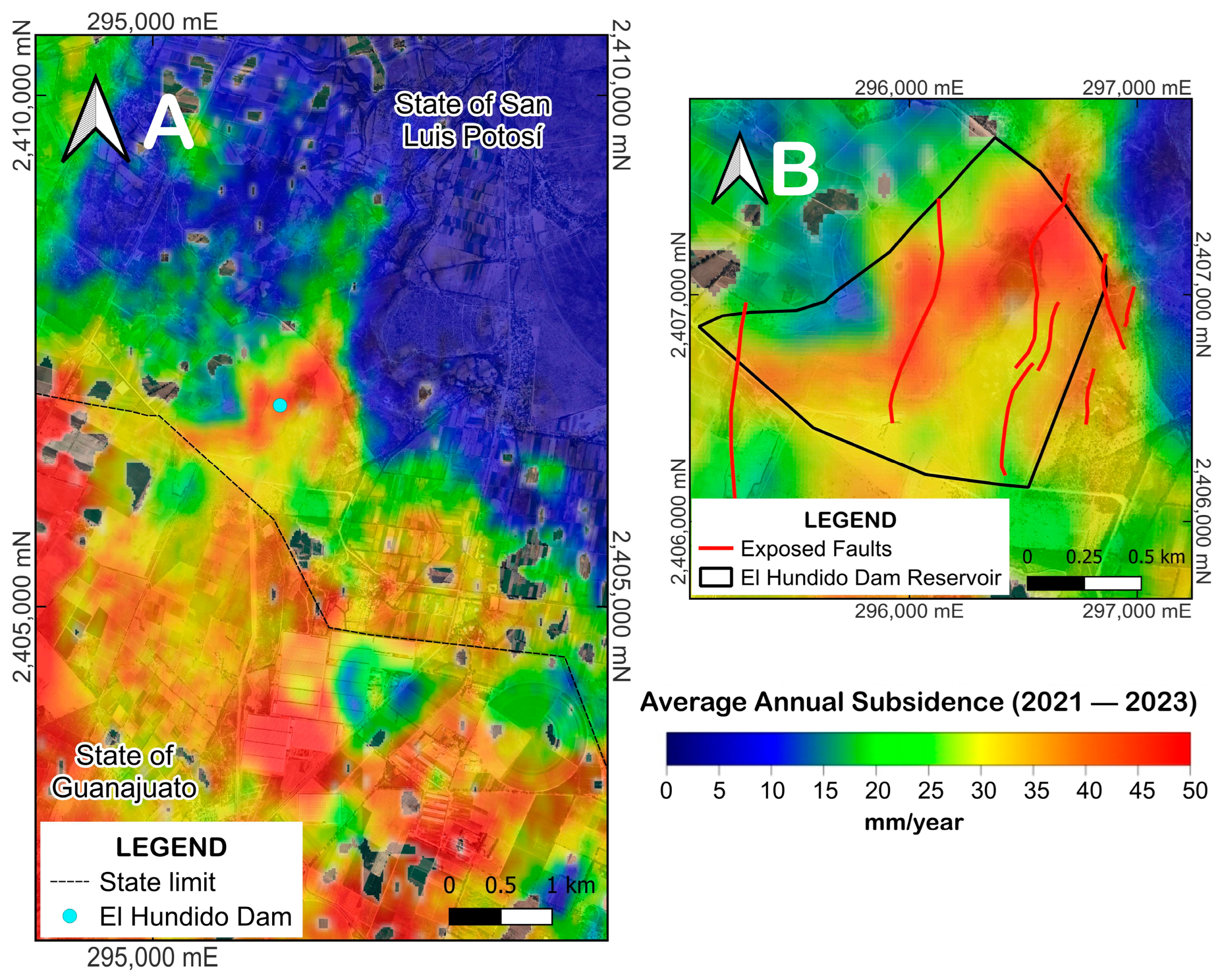
Study Site Description
2. Materials and Methods
2.1. Transient Electromagnetic (TEM) Sounding
2.2. Electromagnetic Profiling (EMP) Method
2.3. Electrical Resistivity Tomography (ERT)
3. Results
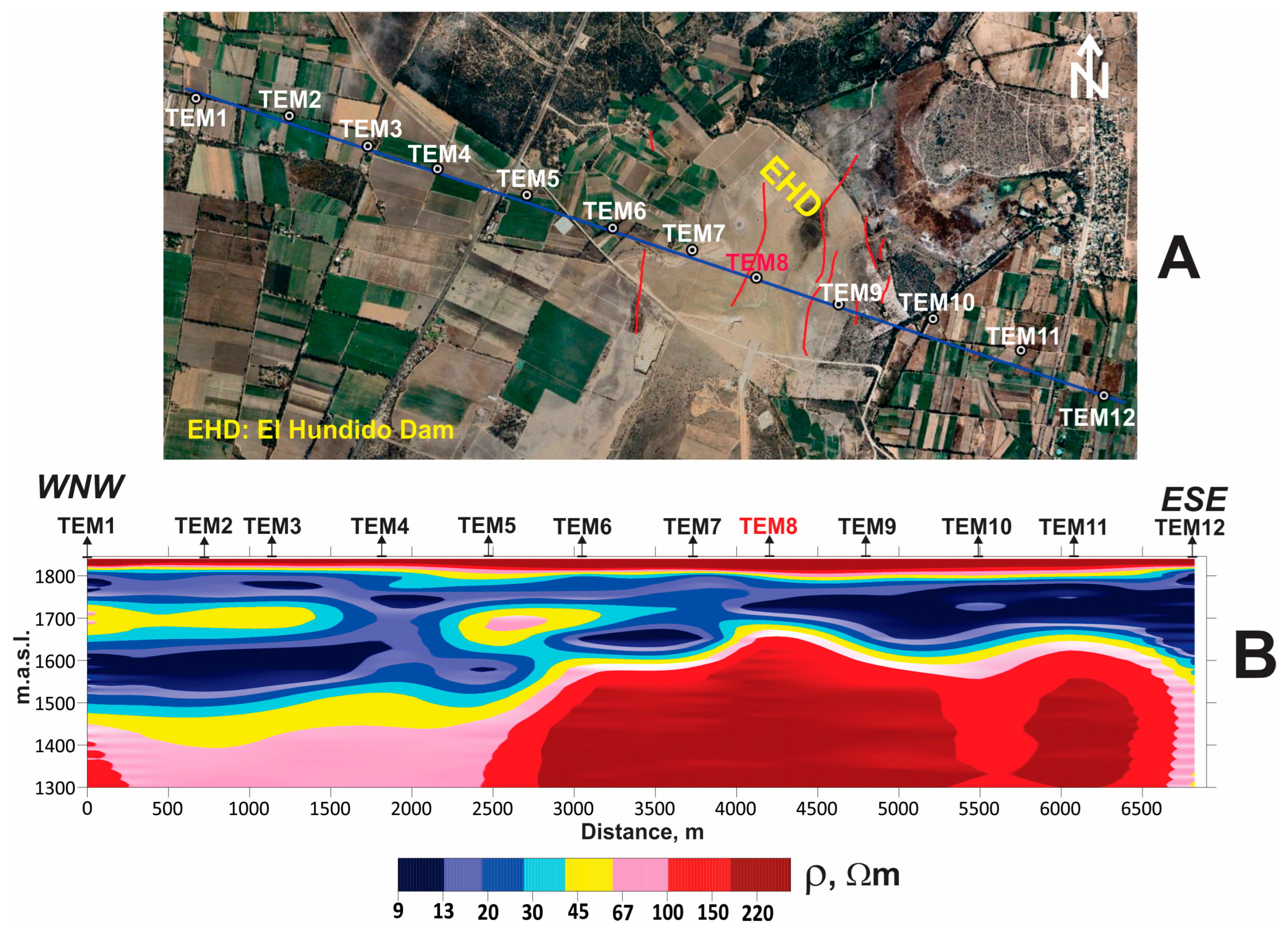
3.1. TEM Results
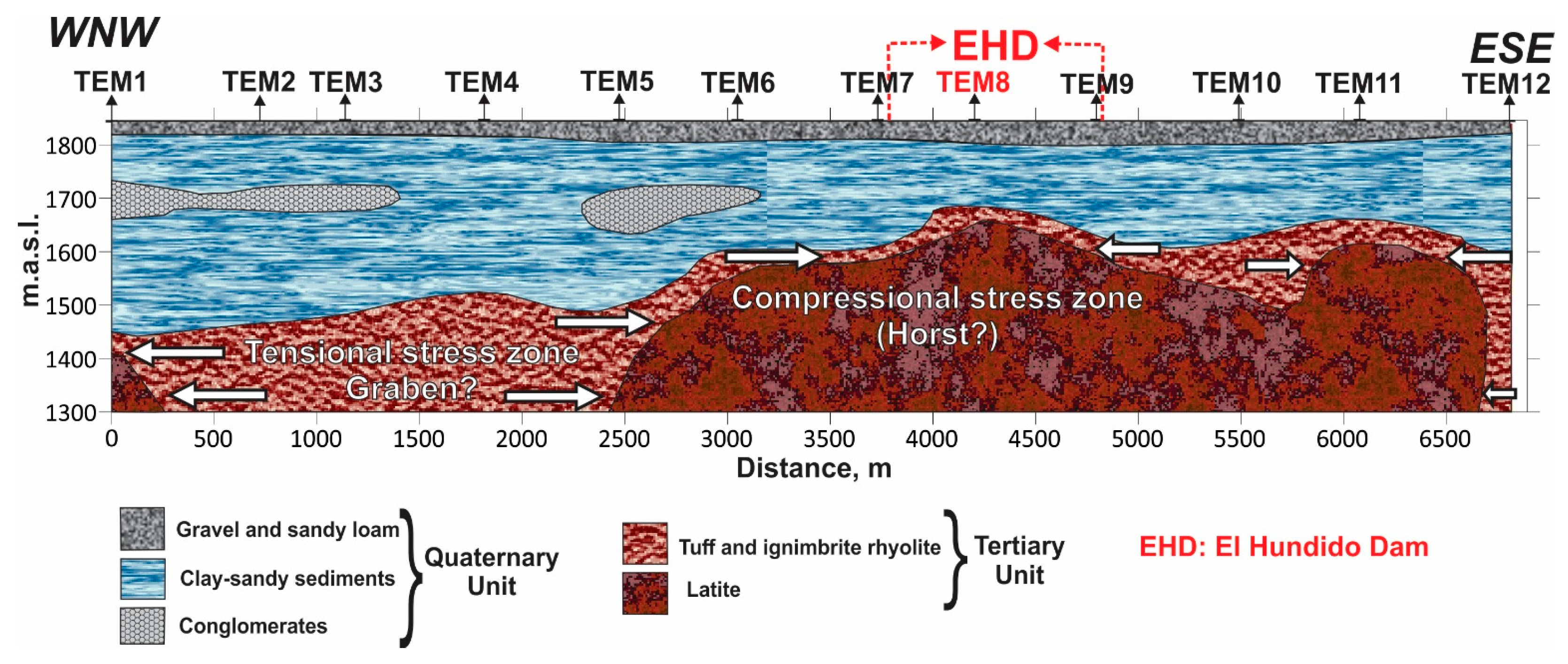
3.1.1. Geoelectrical Section
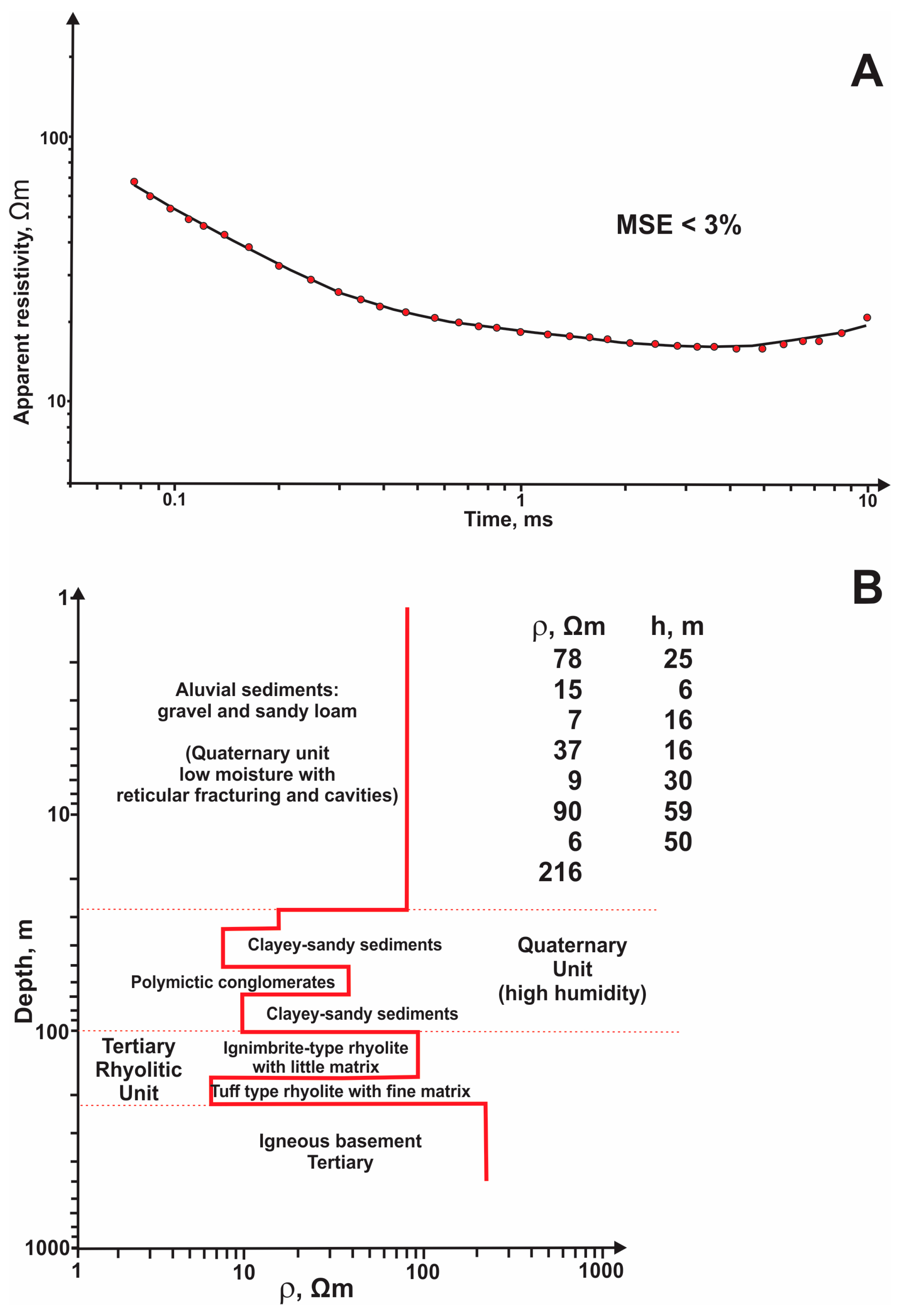
3.1.2. 1D Geological-Geoelectric Model of a Dam Reservoir
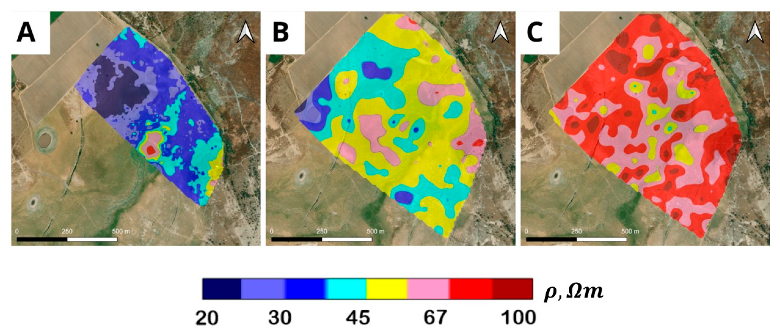
3.2. EMP Survey
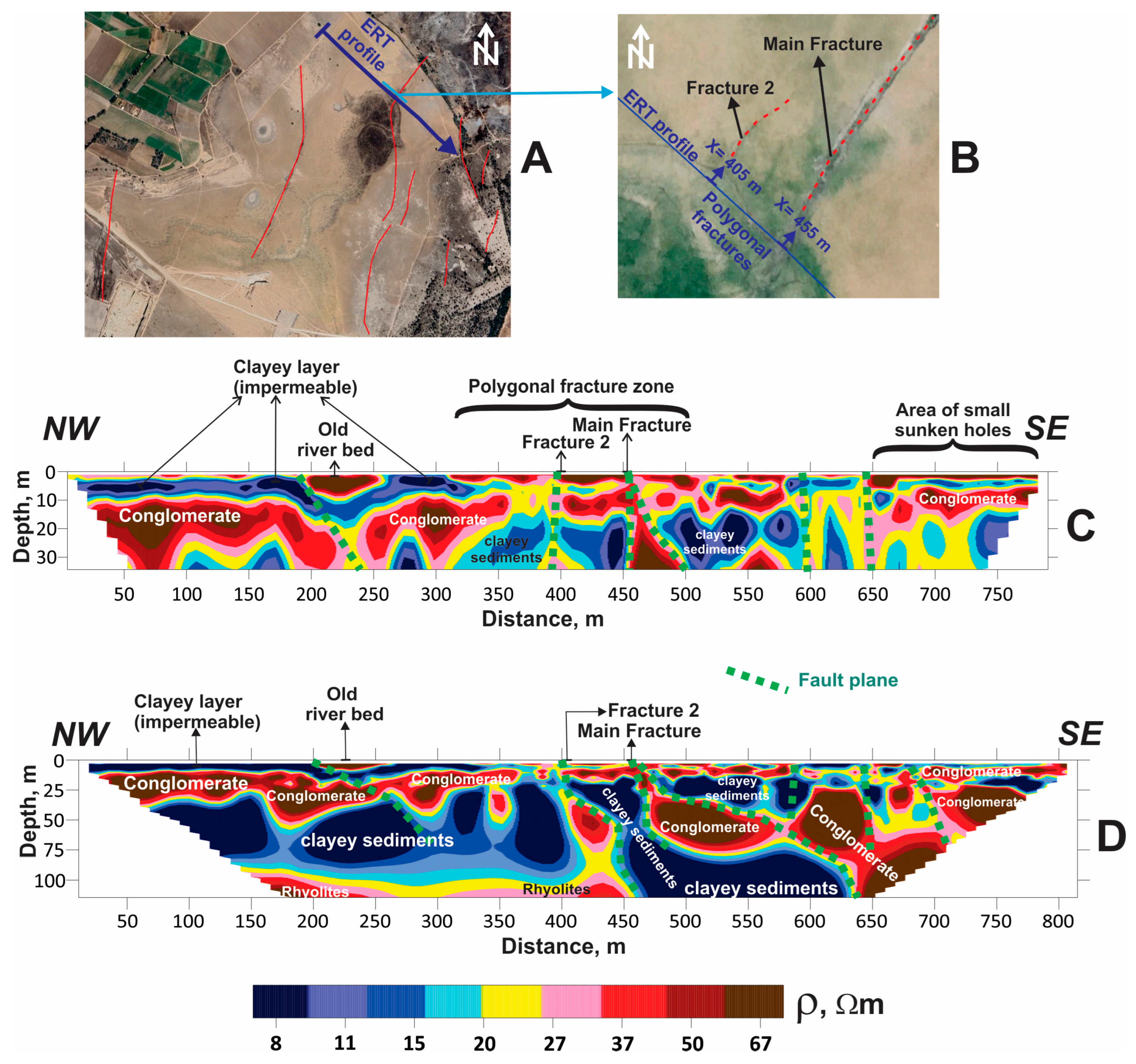
3.3. ERT Results
- Geoelectrical section for 34 m study depth (high resolution)
- Geoelectrical section for 110 m study depth (medium resolution)
4. Discussion
5. Conclusions
Supplementary Materials
Author Contributions
Funding
Data Availability Statement
Acknowledgments
Conflicts of Interest
References
- Davydzenka, T.; Tahmasebi, P.; Shokri, N. Unveiling the Global Extent of Land Subsidence: The Sinking Crisis. Geophys. Res. Lett. 2024, 51, e2023GL104497. [Google Scholar] [CrossRef] [Scilit]
- Devi, A.; Moisio, S. How ‘Sinking Cities’ Can Address Subsidence Challenges. World Economic Forum. Available online: https://www.weforum.org/stories/2024/10/how-sinking-cities-can-address-subsidence-challenges/ (accessed on 25 March 2026).
- Brunori, C.A.; Bignami, C.; Albano, M.; Zucca, F.; Samsonov, S.; Groppelli, G.; Norini, G.; Saroli, M.; Stramondo, S. Land subsidence, Ground Fissures and Buried Faults: InSAR Monitoring of Ciudad Guzmán (Jalisco, Mexico). Remote Sens. 2015, 7, 8610–8630. [Google Scholar] [CrossRef] [Scilit]
- Zisman, E.D.; West, S.D. Hydrocompaction Considerations in Sinkhole Investigations. NCKRI Symp. 2015, 5, 605–611. [Google Scholar] [CrossRef] [Scilit]
- Zumpano, V.; Pisano, L.; Parise, M. An integrated framework to identify and analyze karst sinkholes. Geomorphology 2019, 332, 213–225. [Google Scholar] [CrossRef] [Scilit]
- Bagheri-Gavkosh, M.; Mossa-Hosseini, S.; Ataie-Ashtiani, B.; Sohani, Y.; Ebrahimian, H.; Morovat, F.; Ashrafi, S. Land subsidence: A global challenge. Sci. Total Environ. 2021, 778, 146193. [Google Scholar] [CrossRef] [Scilit]
- Raspini, F.; Caleca, F.; Del Soldato, M.; Festa, D.; Confuorto, P.; Bianchini, S. Review of satellite radar interferometry for subsidence analysis. Earth-Sci. Rev. 2022, 235, 104239. [Google Scholar] [CrossRef] [Scilit]
- Castellazzi, P.; Arroyo-Domínguez, N.; Martel, R.; Calderhead, A.I.; Normand, J.C.L.; Gárfias, J.; Rivera, A. Land subsidence in major cities of Central Mexico: Interpreting InSAR-derived land subsidence mapping with hydrogeological data. Int. J. Appl. Earth Obs. Geoinf. 2016, 47, 102–111. [Google Scholar] [CrossRef] [Scilit]
- Chaussard, E.; Amelung, F.; Wdowinski, S.; Cabral-Cano, E. Magnitude and extent of land subsidence in central Mexico revealed by regional InSAR ALOS time-series survey. Geophys. Res. Abstr. 2013, 15, EGU2013-4841. [Google Scholar]
- Figueroa-Miranda, S.; Hernández-Madrigal, V.; Tuxpan-Vargas, J. Evolution assessment of structurally-controlled differential subsidence using SBAS and PS interferometry in an emblematic case in Central Mexico. Eng. Geol. 2020, 279, 105860. [Google Scholar] [CrossRef] [Scilit]
- Cigna, F.; Tapete, D. Present-day land subsidence rates, surface faulting hazard and risk in Mexico City with 2014–2020 Sentinel-1 IW InSAR. Remote Sens. Environ. 2021, 253, 112161. [Google Scholar] [CrossRef] [Scilit]
- Chaussard, E.; Havazli, E.; Fattahi, H.; Cabral-Cano, E.; Solano-Rojas, D. Over a century of sinking in Mexico City: No hope for significant elevation and storage capacity recovery. J. Geophys. Res. Solid Earth 2021, 126, e2020JB020648. [Google Scholar] [CrossRef] [Scilit]
- Navarro-Hernández, M.I.; Tomás, R.; Lopez-Sanchez, J.M.; Cárdenas-Tristán, A.; Mallorquí, J.J. Spatial Analysis of Land Subsidence in the San Luis Potosi Valley Induced by Aquifer Overexploitation Using the Coherent Pixels Technique (CPT) and Sentinel-1 InSAR Observation. Remote Sens. 2020, 12, 3822. [Google Scholar] [CrossRef] [Scilit]
- Zapata-Norberto, B.; Morales-Casique, E.; Contreras-Galván, R.; Ramos-Leal, J.A. Land subsidence in Mexico City: New insights from field data and numerical modeling. Groundw. Sustain. Dev. 2025, 29, 101432. [Google Scholar] [CrossRef] [Scilit]
- Dindi, E. An assessment of the performance of the geophysical methods as a tool for the detection of zones of potential subsidence in the area southwest of Nakuru town, Kenya. Environ. Earth Sci. 2015, 73, 3643–3653. [Google Scholar] [CrossRef] [Scilit]
- Villaseñor-Reyes, C.I.; Hernández-Madrigal, V.M.; Delgado-Rodríguez, O.; Guevara-Alday, J.A.; Flores-Lázaro, N. 3D deformation velocity field analysis and TEM method to detect the tectonic influence on the land subsidence in Zamora, Mexico. Eng. Geol. 2024, 338, 107636. [Google Scholar] [CrossRef] [Scilit]
- Pacheco, J.; Arzate, J.; Rojas, E.; Arroyo, M.; Yutsis, V.; Ochoa, G. Delimitation of ground failure zones due to land subsidence using gravity data and finite element modeling in the Queretaro valley, Mexico. Eng. Geol. 2006, 84, 143–160. [Google Scholar] [CrossRef] [Scilit]
- Wang, P.; Li, F.; Lu, K.; Huang, W. Detection of water-rich areas and seepage channels via the transient electromagnetic method, electrical resistivity tomography, and self-potential method. Sci. Rep. 2025, 15, 15905. [Google Scholar] [CrossRef] [Scilit] [PubMed]
- Monge-Cerda, F.; Ramos-Leal, J.; Delgado-Rodríguez, O.; Torres-Hernández, J.; Belmonte-Jiménez, S.; Torres-Gaytán, D. Geophysical, geological and tectonic study of active faulting inside the Villa de Reyes Graben, Central México. Near Surf. Geophys. 2025, 23, 460–482. [Google Scholar] [CrossRef] [Scilit]
- CONAGUA. Informe de Inspección a la Presa San Francisco en el Municipio de Villa De Reyes; Subgerencia de Seguridad de Presas; S.L.P. Gerencia Estatal En San Luis Potosí: San Luis Potosí, Mexico, 2000; Volume 3093, p. 7. [Google Scholar]
- Murillo, R. Presas de Tierra y sus Fallas. XXVI Reunión Nacional de Mecánica de Suelos e Ingeniería Geotécnica. Sociedad Mexicana de Ingeniería Geotécnica, A.C. Cancún, Quintana Roo, México. 2012. Available online: https://www.studocu.com/pe/document/universidad-cesar-vallejo/obras-hidraulicas/presas-de-tierra-y-sus-fallas/83484880 (accessed on 18 March 2026).
- Pérez-Martínez, I.; Ramos-Leal, J.A.; Cardona-Benavides, A.; Morán-Ramírez, J.; Villanueva-Estrada, R.E. Caracterización hidrogeoquímica para la identificación y cuantificación de los flujos que dan origen al agua subterránea en un valle tectónico. Environ. Earth Sci. 2021, 80, 772. [Google Scholar] [CrossRef] [Scilit]
- Gutiérrez, F.; Guerrero, J.; Lucha, P. A genetic classification of sinkholes illustrated from evaporite paleokarst exposures in Spain. Environ. Geol. 2008, 53, 993–1006. [Google Scholar] [CrossRef] [Scilit]
- Fannin, R.; Slangen, P. On the distinct phenomena of suffusion and suffosion. Géotechnique Lett. 2014, 4, 289–294. [Google Scholar] [CrossRef] [Scilit]
- Tristán-González, M. Estratigrafía y Tectónica del Graben de Villa de Reyes, en los Estados de San Luis Potosí y Guanajuato; Universidad Autónoma de San Luis Potosí, Instituto de Geología: San Luis Potosí, Mexico, 1986; Volume 107, p. 91. [Google Scholar]
- Nieto-Samaniego, Á.F.; Alaniz-Álvarez, S.A.; Labarthe-Hernández, G. La deformación cenozoica poslaramídica en la parte meridional de la Mesa Central, México. Rev. Mex. Cienc. Geológicas 1997, 14, 13–25. [Google Scholar]
- SGM. Carta Geológico-Minera, Santa María del Río F14-C14, San Luis Potosí y Guanajuato [Map]. Secretaría de Economía. 1997. Available online: http://mapserver.sgm.gob.mx/Cartas_Online/geologia/1462_F14-C14_GM.pdf (accessed on 25 March 2026).
- Labarthe-Hernández, G.; Tristán-González, M.; Aranda-Gómez, J.J. Revisión Estratigráfica del Cenozoico de la Parte Central del Estado de San Luis Potosí; Universidad Autónoma de San Luis Potosí, Instituto de Geología y Metalurgia: San Luis Potosí, Mexico, 1982; p. 85. [Google Scholar]
- Ramos-Leal, J.; López-Loera, H.; Martínez-Ruiz, V.; Aranda-Gómez, J. Sucesión de eventos y geometría de la parte central del acuífero del graben de Villa de Reyes (San Luis Potosí, México) inferida a partir de datos geoeléctricos. Rev. Mex. Cienc. Geológicas 2007, 24, 31–46. [Google Scholar]
- CONAGUA. Consulta De Mediciones Piezométricas. Gerencia De Aguas Subterráneas. 2024. Available online: https://sigagis.conagua.gob.mx/rp20/ (accessed on 20 April 2026).
- INEGI. Distribución Espacial y Magnitud de la Subsidencia en Villa de Reyes, San Luis Potosí en 2022. 2024. Available online: https://www.inegi.org.mx/app/biblioteca/ficha.html?upc=794551118177 (accessed on 20 April 2026).
- Hernández Bocanegra, P.I. Exploración Geofísica e Hidrogeoquímica en el Graben de Villa de Reyes, Para Estudiar el Origen de las Fallas Activas y sus Implicaciones en el Acuífero. Master’s Thesis, Instituto Potosino de Investigación Científica y Tecnológica, San Luis Potosí, Mexico, 2023. Available online: http://hdl.handle.net/11627/6463 (accessed on 17 March 2026).
- Telford, W.M.; Geldart, L.P.; Sheriff, R.E. Resistivity Methods. In Applied Geophysics, 2nd ed.; Cambridge University Press: Cambridge, UK, 1990; pp. 353–358. [Google Scholar] [CrossRef] [Scilit]
- McLachlan, P.; Vang, M.Ø.; Pedersen, J.B.; Kraghede, R.; Christiansen, A.V. Mapping the Hydrogeological Structure of a Small Danish Island Using Transient Electromagnetic Methods. Groundwater 2025, 63, 280–290. [Google Scholar] [CrossRef] [Scilit]
- Lévesque, Y.; Walter, J.; Chesnaux, R. Transient Electromagnetic (TEM) Surveys as a First Approach for Characterizing a Regional Aquifer: The Case of the Saint-Narcisse Moraine, Quebec, Canada. Geosciences 2021, 11, 415. [Google Scholar] [CrossRef] [Scilit]
- Zhang, Y.; Wu, Y.; Zheng, H.; Xu, Y.; Cheng, X. Application of TEM and HDRM in hydrogeophysical surveys in Meisibulake coal mine. Sci. Rep. 2022, 12, 21368. [Google Scholar] [CrossRef] [Scilit]
- Rajab, J.A.; Yogeshwar, P.; Tezkan, B. Transient electromagnetic imaging of saltwater intrusion at the shrinking Dead Sea. Sci. Rep. 2025, 15, 30250. [Google Scholar] [CrossRef] [Scilit] [PubMed]
- Zhu, Z.; Shan, Z.; Pang, Y.; Wang, W.; Chen, M.; Li, G.; Sun, H.; Revil, A. The transient electromagnetic (TEM) method reveals the role of tectonic faults in seawater intrusion at Zhoushan islands (Hangzhou Bay, China). Eng. Geol. 2024, 330, 107425. [Google Scholar] [CrossRef] [Scilit]
- Zamora-Luria, J.C.; McLachlan, P.; Christiansen, A.V. Long-term monitoring of water table and saltwater intrusion dynamics through time-lapse transient electromagnetic. Near Surf. Geophys. 2024, 22, 636–651. [Google Scholar] [CrossRef] [Scilit]
- Law, D.; Mohd Noh, K.A.; Md Rafek, A.G. Application of transient electromagnetic (TEM) method for delineation of mineralized fracture zones. In Proceedings of the OP Conference Series: Earth and Environmental Science, The International Conference on Geoscience, Makassar, Indonesia, 1–2 November 2018; Volume 279. [Google Scholar] [CrossRef] [Scilit]
- Wu, J.; Zhi, Q.; Wang, X.; Deng, X.; Liu, Y.; Chen, X. Fixed-loop TEM surveying using the SQUID magnetometer for deep mineral exploration in a conductive area. J. Geophys. Eng. 2022, 19, 1300–1307. [Google Scholar] [CrossRef] [Scilit]
- Guo, Z.; Xue, G.; Liu, J.; Wu, X. Electromagnetic methods for mineral exploration in China: A review. Ore Geol. Rev. 2020, 118, 103357. [Google Scholar] [CrossRef] [Scilit]
- Barsukov, P.O.; Fainberg, E.B. Mapping bedrock topography and moraine deposits by transient electromagnetic sounding: Oslo graben, Norway. Near Surf. Geophys. 2020, 18, 123–133. [Google Scholar] [CrossRef] [Scilit]
- Bastani, M.; Persson, L.; Löfroth, H.; Smith, C.A. Comparison between ATEM, RMT, ERT and CPTR Data at a Quick Clay Site in Sweden. In Proceedings of the Presented at the Second European Airborne Electromagnetics Conference, Malmö, Sweden, 3–7 September 2017. [Google Scholar] [CrossRef] [Scilit]
- Dhamiry, N.M.; Zouaghi, T. Near-surface geophysical surveys for bedrock investigation and modeling for grain silos site, Yanbu City, Western Saudi Arabia. Model. Earth Syst. Environ. 2020, 6, 51–61. [Google Scholar] [CrossRef] [Scilit]
- Monex GeoScope. Introducing the terraTEM24 Transient EM System. 2022. Available online: https://www.monexgeoscope.com.au/wp-content/uploads/2022/07/terraTEM24-brochure.pdf (accessed on 25 March 2026).
- Kaufman, A.A.; Keller, G.V. The Magnetotelluric Sounding Method. Methods in Geochemistry and Geophysics; Elsevier Scientific: Amsterdam, The Netherlands, 1981; Volume 15, pp. 357–421. [Google Scholar] [CrossRef] [Scilit]
- Nabighian, M.N. Quasi-static transient response of a conducting half-space: An approximate representation. Geophysics 1979, 44, 1700–1705. [Google Scholar] [CrossRef] [Scilit]
- Christiansen, A.V.; Auken, E.; Sorensen, K. The transient electromagnetic method. In Groundwater Geophysics; Kirsch, R., Ed.; 2006; pp. 179–225. [Google Scholar] [CrossRef] [Scilit]
- Geosystem, S.R.L. WingLink Ver 2.1.1: A Guide to Using; Geosystem, S.R.L: Florence, Italy, 2003; pp. 158–165. Available online: https://es.scribd.com/document/455228621/winglink-2-01-01 (accessed on 25 March 2026).
- Nekut, A.G. Direct inversion of time-domain electromagnetic data. Geophysics 1987, 52, 1431–1435. [Google Scholar] [CrossRef] [Scilit]
- Grant, F. Explorationist’s Guide. (Book Reviews: Electrical Methods in Geophysical Prospecting). Science 1967, 155, 1234. [Google Scholar] [CrossRef] [Scilit]
- Gf Instruments, S.R.O. CMD Electromagnetic Conductivity Meters for Multi-Layer Survey. Geophysical Equipment and Services. 2020. Available online: http://www.gfinstruments.cz/version_cz/downloads/CMD_2020.pdf (accessed on 15 March 2026).
- Loke, M.H.; Dahlin, T.; Leroux, V. Constrained time-lapse inversion of 3-D resistivity surveys data. In Proceedings of the Near Surface 2011-17th EAGE European Meeting of Environmental and Engineering Geophysics, Leicester, UK, 12–14 September 2011; Available online: https://www.earthdoc.org/content/papers/10.3997/2214-4609.20144428 (accessed on 25 March 2026).
- Delgado-Rodríguez, O.; Flores-Hernández, D.; Amezcua-Allieri, M.A.; Shevnin, V.; Rosas-Molina, A.; Marin-Córdova, S. Joint interpretation of geoelectrical and volatile organic compounds data: A case study in a hydrocarbon contaminated urban site. Geofísica Int. 2014, 53, 183–198. [Google Scholar] [CrossRef] [Scilit]
- Cordero-Vázquez, C.Y.; Delgado-Rodríguez, O.; Cisneros-Almazán, R.; Peinado-Guevara, H.J. Determination of Soil Physical Properties and Pre-Sowing Irrigation Depth from Electrical Resistivity, Moisture, and Salinity Measurements. Land 2023, 12, 877. [Google Scholar] [CrossRef] [Scilit]
- Çağlayan Balkaya, C.; Ekinci, Y.L.; Çakmak, O.; Blömer, M.; Arnkens, J.; Kaya, M.A. A challenging archaeo-geophysical exploration through GPR and ERT surveys on the Keber Tepe, City Hill of Doliche, Commagene (Gaziantep, SE Turkey). J. Appl. Geophys. 2021, 186, 104272. [Google Scholar] [CrossRef] [Scilit]
- Singh, S.; Tripura, J. Combined ERT survey and pumping test for correlation analysis of geoelectrical and aquifer parameters in hilly terrain. J. Earth Syst. Sci. 2023, 132, 43. [Google Scholar] [CrossRef] [Scilit]
- Monge-Cerda, F.E.; Delgado-Rodríguez, O.; Ramos-Leal, J.A.; Sánchez-Higueredo, L.E. Geoelectrical characterization of non-filled active faults in Jaral de Berrios, Guanajuato, México. J. Appl. Geophys. 2024, 227, 105431. [Google Scholar] [CrossRef] [Scilit]
- AGI. SuperSting Wi-Fi 2023. Available online: https://www.agiusa.com/node/159 (accessed on 25 March 2026).
- Loke, M.H. Tutorial: 2-D and 3-D Electrical Imaging Surveys. Revised version November. 2025. Available online: https://www.geotomosoft.com/downloads.php (accessed on 20 April 2026).
- Loke, M.H. RES2DMOD Ver. 3.01, Rapid 2-D Resistivity forward Modeling Using the Finite-Difference and Finiteelement Methods, Geotomo Software. 2002. Available online: https://is.muni.cz/el/phil/podzim2012/AEB_124/35662789/EL_pdf_5_RES2DMOD.PDF (accessed on 25 March 2026).
- Sasaki, Y. Resolution of resistivity tomography inferred from numerical SIMULATION1. Geophys. Prospect. 1992, 40, 453–463. [Google Scholar] [CrossRef] [Scilit]
- Loke, M.H.; Barker, R.D. Rapid Least-Squares Inversion of Apparent Resistivity Pseudosections by a Quasi-Newton Method. Geophys. Prospect. 1996, 44, 131–152. [Google Scholar] [CrossRef] [Scilit]
- Suski, B.; Brocard, G.; Authemayou, C.; Muralles, B.; Teyssier, C.; Holliger, K. Localization and characterization of an active fault in an urbanized area in central Guatemala by means of geoelectrical imaging. Tectonophysics 2010, 480, 88–98. [Google Scholar] [CrossRef] [Scilit]
- Loke, M.H.; Rucker, D.F.; Chambers, J.E.; Wilkinson, P.B.; Kuras, O. Electrical Resistivity Surveys and Data Interpretation. In Encyclopedia of Solid Earth Geophysics; Encyclopedia of Earth Sciences Series; Gupta, H., Ed.; Springer: Cham, Germany, 2020. [Google Scholar] [CrossRef] [Scilit]
- Golden Software. Surfer 16 User’s Guide. Golden Software: Golden, CO, USA, 2018; p. 194. Available online: http://downloads.goldensoftware.com/guides/Surfer16UsersGuidePreview.pdf (accessed on 25 March 2026).
- CONAGUA. Actualización de la disponibilidad media anual de agua en el acuífero Jaral de Berrios-Villa de Reyes (2412), Estado de San Luis Potosí. Subdirección General Técnica. Gerencia De Aguas Subterráneas. 2020. Available online: https://sigagis.conagua.gob.mx/gas1/Edos_Acuiferos_18/sanluispotosi/DR_2412.pdf (accessed on 17 March 2026).
- Nkodia, H.M.D.-V.; Miyouna, T.; Delvaux, D.; Boudzoumou, F. Flower structures in sandstones of the Paleozoic Inkisi Group (Brazzaville, Republic of Congo): Evidence for two major strike-slip fault systems and geodynamic implications. S. Afr. J. Geol. 2020, 123, 531–550. [Google Scholar] [CrossRef] [Scilit]


Disclaimer/Publisher’s Note: The statements, opinions and data contained in all publications are solely those of the individual author(s) and contributor(s) and not of MDPI and/or the editor(s). MDPI and/or the editor(s) disclaim responsibility for any injury to people or property resulting from any ideas, methods, instructions or products referred to in the content. |
© 2026 by the authors. Licensee MDPI, Basel, Switzerland. This article is an open access article distributed under the terms and conditions of the Creative Commons Attribution (CC BY) license.
Share and Cite
Trejo-Martínez, X.M.; Delgado-Rodríguez, O.; Ramos-Leal, J.A.; Peinado-Guevara, H.J.; Carranco-Lozada, S.E. Subsoil Characterisation in an Abandoned Dam in Central Mexico Using Geoelectrical Methods. Geosciences 2026, 16, 209. https://doi.org/10.3390/geosciences16060209
Trejo-Martínez XM, Delgado-Rodríguez O, Ramos-Leal JA, Peinado-Guevara HJ, Carranco-Lozada SE. Subsoil Characterisation in an Abandoned Dam in Central Mexico Using Geoelectrical Methods. Geosciences. 2026; 16(6):209. https://doi.org/10.3390/geosciences16060209
Chicago/Turabian StyleTrejo-Martínez, Ximena Michelle, Omar Delgado-Rodríguez, José Alfredo Ramos-Leal, Héctor José Peinado-Guevara, and Simón Eduardo Carranco-Lozada. 2026. "Subsoil Characterisation in an Abandoned Dam in Central Mexico Using Geoelectrical Methods" Geosciences 16, no. 6: 209. https://doi.org/10.3390/geosciences16060209
APA StyleTrejo-Martínez, X. M., Delgado-Rodríguez, O., Ramos-Leal, J. A., Peinado-Guevara, H. J., & Carranco-Lozada, S. E. (2026). Subsoil Characterisation in an Abandoned Dam in Central Mexico Using Geoelectrical Methods. Geosciences, 16(6), 209. https://doi.org/10.3390/geosciences16060209