Article

How Academics and the Public Experienced Immersive Virtual Reality for Geo-Education

by
Fabio L. Bonali
1,2,*,
Elena Russo
1,
Fabio Vitello
3,
Varvara Antoniou
4,
Fabio Marchese
1,†,
Luca Fallati
1,
Valentina Bracchi
1,
Noemi Corti
1,
Alessandra Savini
1,
Malcolm Whitworth
5,
Kyriaki Drymoni
1,
Federico Pasquaré Mariotto
6,
Paraskevi Nomikou
4,
Eva Sciacca
7,
Sofia Bressan
1,
Susanna Falsaperla
8,
Danilo Reitano
8,
Benjamin van Wyk de Vries
9,
Mel Krokos
10,
Giuliana Panieri
11,
Mathew Alexander Stiller-Reeve
12,13,
Giuseppe Vizzari
14,
Ugo Becciani
7 and
Alessandro Tibaldi
1,2
add Show full author list remove Hide full author list
1
Department of Earth and Environmental Sciences, University of Milan Bicocca, Piazza della Scienza 1-4, 20126 Milan, Italy
2
CRUST-Interuniversity Center for 3D Seismotectonics with Territorial Applications, 66100 Chieti, Italy
3
INAF-Istituto di Radioastronomia, via Gobetti 101, 40129 Bologna, Italy
4
Department of Geology and Geoenvironment, National and Kapodistrian University of Athens, 15784 Athens, Greece
5
School of the Environment, Geography and Geosciences, University of Portsmouth, Portsmouth PL01 3QL, UK
6
Department of Human and Innovation Sciences, Insubria University, Via S. Abbondio 12, 22100 Como, Italy
7
INAF-Osservatorio Astrofisico di Catania, Via Santa Sofia 78, 95123 Catania, Italy
8
Istituto Nazionale di Geofisica e Vulcanologia-Osservatorio Etneo, Piazza Roma 2, 95125 Catania, Italy
9
Laboratoire Magmas et Volcans, Observatoire du Physique du Globed e Clermont, IRD, UMR6524-CNRS, Université Clermont Auvergne, 63170 Aubiere, France
10
School of Creative Technologies, University of Portsmouth, Portsmouth PO1 2DJ, UK
11
CAGE, Center for Arctic Gas Hydrate, Environment and Climate, The Arctic University of Norway, 9019 Tromso, Norway
12
Konsulent Stiller-Reeve, 5281 Valestrandsfossen, Norway
13
Center for Climate and Energy Transformation, University of Bergen, 5020 Bergen, Norway
14
Department of Informatics, Systems and Communication, University of Milan Bicocca, Viale Sarca 336/14, 20126 Milan, Italy
*
Author to whom correspondence should be addressed.
Now at Red Sea Research Center, King Abdullah University of Science and Technology, Thuwal 23955-6900, Saudi Arabia.
Geosciences 2022, 12(1), 9; https://doi.org/10.3390/geosciences12010009
Submission received: 26 November 2021 / Revised: 19 December 2021 / Accepted: 21 December 2021 / Published: 24 December 2021

Abstract

:
Immersive virtual reality can potentially open up interesting geological sites to students, academics and others who may not have had the opportunity to visit such sites previously. We study how users perceive the usefulness of an immersive virtual reality approach applied to Earth Sciences teaching and communication. During nine immersive virtual reality-based events held in 2018 and 2019 in various locations (Vienna in Austria, Milan and Catania in Italy, Santorini in Greece), a large number of visitors had the opportunity to navigate, in immersive mode, across geological landscapes reconstructed by cutting-edge, unmanned aerial system-based photogrammetry techniques. The reconstructed virtual geological environments are specifically chosen virtual geosites, from Santorini (Greece), the North Volcanic Zone (Iceland), and Mt. Etna (Italy). Following the user experiences, we collected 459 questionnaires, with a large spread in participant age and cultural background. We find that the majority of respondents would be willing to repeat the immersive virtual reality experience, and importantly, most of the students and Earth Science academics who took part in the navigation confirmed the usefulness of this approach for geo-education purposes.

1. Introduction

Virtual reality (VR) is considered as a modern approach that provides 3D visualization in geological sciences, geoinformation for data collection and dissemination [1,2,3], as well as an immersive user experience [4,5]. Nowadays, VR landscapes can also rely on open or ad hoc-created geospatial datasets (e.g., [2]), including digital terrain and photogrammetry-derived 3D models [6], as well as bathymetric data [4]. The latter are also provided in the form of virtual outcrops and virtual geosites, and are considered as a key strategy to overcome common difficulties among students, such as visualizing three-dimensional concepts on a two-dimensional medium (for instance, a book), or on an image-based virtual tour [7,8,9].
A first attempt to apply VR techniques to studying geomorphological processes was made by Hilde et al. [10] and Anderson [11], who applied 3D visualization techniques to picturing ocean bottom topography by reconstructing a 3D scenario and a 3D tour. Subsequently, Anderson [12] refined the first approximation approach of Hilde et al. [10] to produce three-dimensional models of Mars using Viking Orbiter images, to study an extended period of glaciation in the Elysium Region. Other VR approaches focused on organising the so-called virtual tours of key outcrops, geolocated in a GIS platform, navigated by students by visualizing and studying 2-D images [7,8,9] or 3D digital outcrop models [13]. This approach has been introduced to support teaching activity in Earth Sciences, to reduce teaching costs, and to improve student learning efficiency and increase learning interest [9].
In addition, virtual tours have been useful at different stages: as a digital review before field campaigns, as a tutorial review, and as a digital asset substitute for field site inspection [8]. A mixed approach proposed a number of 3D models to be explored similarly to a virtual tour, using a PC, a tablet or a Smartphone; for example, McCaffrey et al. [14] applied this approach to petroleum geoscience, whereas Pasquaré Mariotto et al. [3] combined the use of virtual geosites with a WebGIS Platform (https://arcg.is/1e4erK0 (accessed on 26 November 2021)) to improve geoheritage communication.
VR applications have been increasingly used in recent years for geoscience education, scientific research, geoheritage communication and geotourism purposes; in fact, due to this approach, geological sites are made more accessible and available, including those that are dangerous or expensive to travel to, or have limited access. According to previous research efforts [3,15], this can be largely attributed to the possibility of making 3D models available as a free web resource, providing users with a number of virtual geological landscapes. These are the so-called virtual outcrops or virtual geosites, which are available to the public via web resources and represent, in 3D, geomorphological features and structures with photorealistic textures, based on photogrammetry techniques [3,6]. As such, virtual geosites can be an innovative tool for popularizing geoheritage in a broader audience by explaining ongoing, active geological and environmental processes [3,15,16]. Virtual geosites can also engage younger generations, who are particularly interested in highly interactive forms of communication and teaching [15]. An important advancement in the exploration of virtual outcrops and virtual geosites is the immersive virtual reality approach tailored by Tibaldi et al. [5], which has been developed in the framework of two research and innovation projects: namely the Italian Argo3D (https://argo3d.unimib.it/ (accessed on 26 November 2021)) and the EU Erasmus + 3DTeLC (http://3dtelc.lmv.uca.fr/ (accessed on 26 November 2021)) Projects.
In these projects, users can explore virtual geosites in the first person, thus experiencing the feeling of an immersive environment as if they were directly in the field. Furthermore, they can either walk or fly in photorealistic and photogrammetry-based landscapes (virtual scenarios) [6]. This possibility allows them to explore remote or inaccessible areas that would not be accessible otherwise, e.g., when vertical cliffs are present or when exploring recent volcanically and tectonically active areas.
With the final aim of raising awareness about the above-cited projects, we organized nine educational events, with the total participation of 459 attendees, belonging to different age groups and cultural backgrounds, ranging from the lay public to highly-specialised scientific community members, and involving both students and researchers in Earth Sciences.
The participants firstly experienced immersive virtual reality and afterwards provided their feedback on the experience via anonymous questionnaires, the results of which are presented in this paper. Participants were categorised in the following five groups, four of which are subgroups:
(i)
All Participants;
(ii)
Academics/Researchers in Earth Sciences (Academics) that include PhD students and postdocs;
(iii)
MSc Students in Earth Sciences (MSc);
(iv)
Middle and High School Students (Schools students);
(v)
Lay Public (i.e., participants that do not belong to the other groups).
For the dissemination events, we selected four Virtual Geosites which are considered as stunning volcano–tectonic environments due to their cultural, historical and scientific value. These are: the Metaxa Mine located in the Santorini volcanic complex in Greece [17]; a rift-transform triple-junction [18]; the 1984 Krafla eruption area [19], both located along the North Volcanic Zone (NVZ) of Iceland; and the Mt Pizzillo area, situated in the NE rift of Mt Etna, Italy [20].
In this paper, we explore the impact of immersive virtual reality as applied to geological exploration aimed at geo-education, geological exploration and, potentially, geotourism in volcanic areas.

2. Materials and Methods

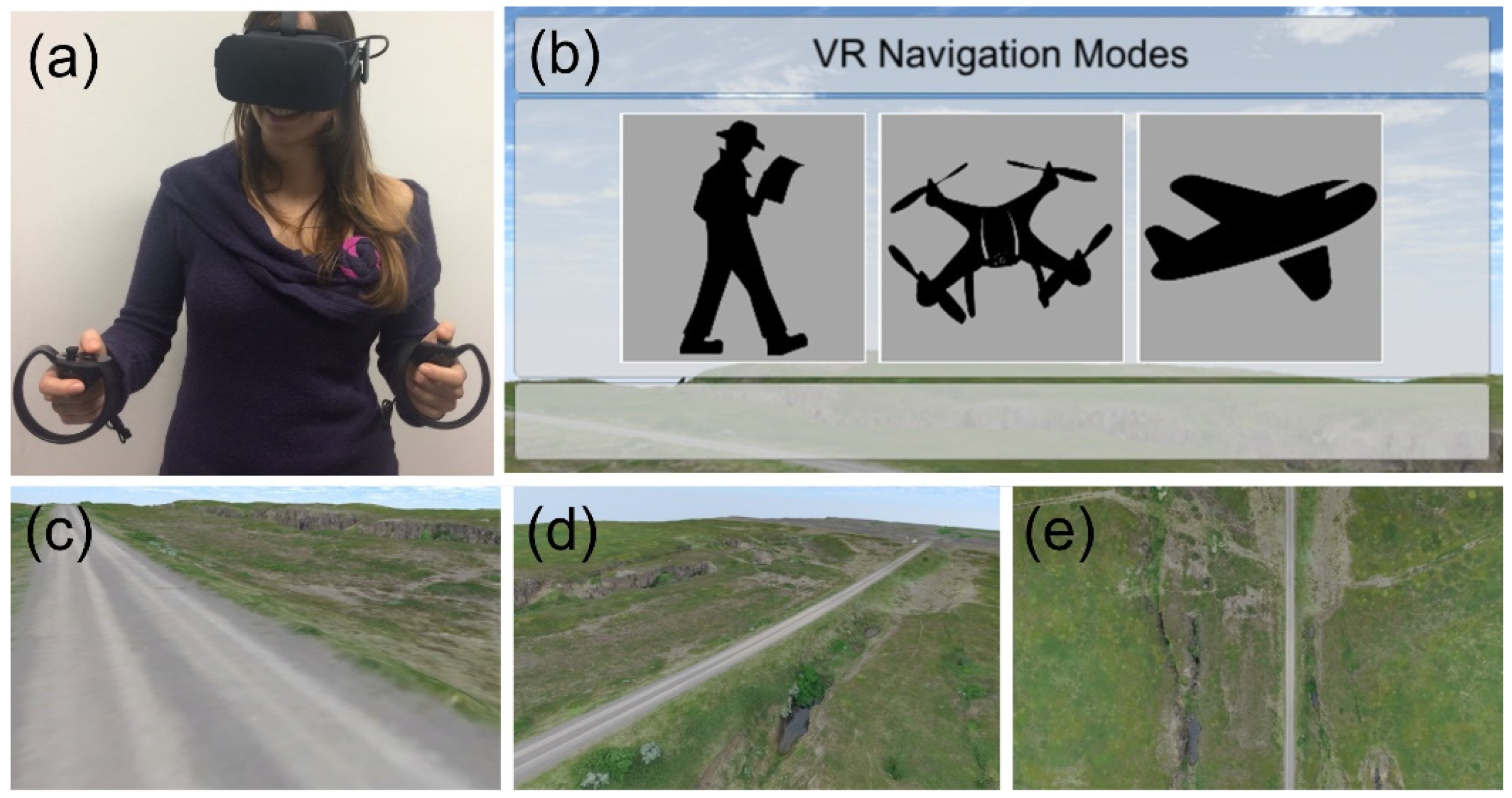
2.1. Immersive Virtual Reality Approach

As detailed in Choi et al. [21], VR applications can be classified as non-immersive and, more importantly, fully immersive experiences. Non-immersive VR is typically referred to as 3D visualization and displays 3D models on a computer screen and/or mobile device without using any head-mounted displays. Fully immersive VR was applied during our dissemination activities and provided users with virtual ways to explore classical geological sites, being able to fly above virtual landscapes, using a suitable VR headset and thumbsticks. Users were provided with a holistic view of a virtual geosite, which allowed them to explore specific geomorphological and volcanotectonic features at a range of different aerial scales. This approach has been fully developed for Earth Sciences by Tibaldi et al. [5], with contributions from Gerloni et al. [22] and Krokos et al. [6]. The former has introduced a navigation mechanism dedicated to explore outcrops in a fully immersive way by replicating real-world field exploration. This approach is based on an offline-based visual discovery framework developed with the Unity game engine (https://unity.com (accessed on 26 November 2021)). The application employs an Oculus Rift (https://www.oculus.com (accessed on 26 November 2021)) as a head-mounted VR device and allows earth scientists to navigate in their own immersive VR scenarios, based on photo-realistic photogrammetry outputs [6].
In our immersive virtual reality application, the landscape was built upon unmanned aerial system (UAS)-based photogrammetry techniques and is thus able to provide centimetric pixel size resolution for the resulting virtual landscape in the form of a 3D model. This has been successfully applied to models of different aerial extents and resolutions, ranging from about 50 to 1000 m (among the longest) and from 0.8 to 4 cm/pixel, respectively.
We used Agisoft Metashape (https://www.agisoft.com/ (accessed on 26 November 2021)) to process the 3D-model and generate a Wavefront OBJ Tiled model, which was designed and tested as the landscape input for our approach by Krokos et al. [6], Tibaldi et al. [6] and Antoniou et al. [17]. The use of 3D tiled models enabled us to obtain reliable representations of geometrical features especially when the objects are oblique to the studied outcrop.
When the user starts their virtual exploration, they walk around on a “solid ground surface” (Figure 1a–c), moving with the thumbsticks on the controllers. Our immersive virtual reality system allows them to choose between three different modes to navigate the scenery, named “walk mode”, “drone mode” and “flight mode”(Figure 1b). In the default “walk mode”, the user can navigate the virtual geosite slowly at a virtual height of around 2 m. (Figure 1c). In the “drone mode”, the user can experience the site as a radio-controlled drone, flying above the virtual landscape. In the “flight mode” (Figure 1e), the user moves to a higher elevation and looks down over the terrain. This mode allows the user to move across the site at the fastest speed.

2.2. Dissemination Events

The dissemination events described below were held between 2018 and 2019 in Italy, Greece, and Austria. Each participant was offered the possibility to explore two virtual geosites of their personal choice, each for five minutes, for a total of 10 min for each participant, during which they tried all three navigation modes.
During the virtual exploration, each user was supported by a trained staff member, who was knowledgeable about the virtual geosites and the use of the immersive tools. The aim was to offer a navigation tutorial to the user, so that they could quickly grasp the main geological and geomorphological features of the selected site. The dissemination events were as follows:
  • Title: Field exploration using immersive virtual reality in the framework of the “B.Inclusion days” (https://www.unimib.it/eventi/binclusion-days-2018), held at the University of Milan-Bicocca, Italy. This event was supported by the EGU 2018 Public Engagement Grant (https://www.egu.eu/news/400/egu-2018-public-engagement-grants-awarded-to-suzanne-imber-and-fabio-bonali/) and was held in collaboration with the Disability and DSA (Disabled Students’ Allowance) service of the University of Milan-Bicocca (https://en.unimib.it/services/bicocca-campus/disability) (10 October 2018). During this event we collected feeback from 25 participants aged 20–56.
  • Title: Santorini Summer School, in the framework of the EU Erasmus + Project—Bringing the 3D-world into the classroom: a new approach to Teaching, Learning and Communicating the science of geohazards in terrestrial and marine environments (http://3dtelc.lmv.uca.fr/). This event was held in Santorini (Thira), Greece (12–21 October 2018). On this occasion, we collected 14 feedback forms from participants aged 23–30.
  • Title: Volcano-tectonic applications using immersive virtual reality. This event was held in Milan, Italy, at the University of Milan-Bicocca, in the framework of a class in active tectonics and volcano tectonic settings held by Prof. Alessandro Tibaldi (https://en.unimib.it/alessandro-tibaldi) (10 January 2019). During this event we collected 10 feedback forms from participants aged 22–24.
  • Title: Geological exploration without barriers: Shaping geological 3D virtual field-surveys for overcoming motor disabilities, held at the University of Milan-Bicocca, Milan, Italy (16 January 2019). This event was supported by the EGU 2018 Public Engagement Grant (https://www.egu.eu/news/400/egu-2018-public-engagement-grants-awarded-to-suzanne-imber-and-fabio-bonali/) and was held in collaboration with the Disability and DSA (Disabled Students’ Allowance) service of the University of Milano-Bicocca (https://en.unimib.it/services/bicocca-campus/disability). At this event we collected 37 feedback forms and the age of the participants was 19–59.
  • Title: Geological exploration using Immersive Virtual Reality. This event was held in Milan at the University of Milan-Bicocca (https://www.unimib.it/eventi/realta-virtuale-immersiva-esplorare-territorio) in the framework of the Digital Week event (https://www.milanodigitalweek.com/), Italy (16 March 2019). During this event we collected data from 24 participants, the age of participants ranging 20–73.
  • Title: Primavera in Bicocca 2019 (https://www.unimib.it/sites/default/files/orientamento/programma_primavera_in_bicocca_2019.pdf) (21 March 2019). This event was held in Milan at the University of Milan-Bicocca, Italy. During this event we collected 10 feedback forms and the participants’ age was 18–20.
  • Title: Geological exploration without barriers in tour. This event was held at the National Institute of Astrophysics (INAF), Catania, Italy and was supported by Argo3D funding (https://argo3d.unimib.it/) (30 March 2019). During this event we collected 21 questionnaires, and the age of the participants was 13–18.
  • Title: Virtual reality for geohazards and geological studies, held in Vienna during the EGU General Assembly 2019 (https://www.egu2019.eu/), Austria Center, Austria (7–12 April 2019). The event was supported by the EGU outreach committee (https://www.egu.eu/outreach/). On this occasion we collected 155 feedback forms and the age of the participants was 21–70.
  • Title: 3D and immersive Virtual Reality: new frontiers in geological exploration. This event was held during the MeetMeTonight event (https://www.meetmetonight.it/), at the Natural Sciences Museum of Milan, Italy (27–28 September 2019). During this event we collected 163 feedback forms, and the age of the participants was 13–66.

2.3. Questionnaires

The aim of the questionnaires was to obtain feedback from people of different ages and backgrounds for the use of photorealistic immersive virtual reality in Earth Sciences, and to explore its applicability to teaching and studying as well as for communication purposes. The questions were categorised into three main groups: (i) general information and questions; (ii) general questions about the experience; (iii) specific questions about its use in Earth Sciences applications.
To facilitate the participants’ replies, a specific procedure was designed. Firstly, the participants were asked to fill in an authorization form. For minors under the age of 18, parents were asked to fill in the authorization forms on their behalf. Once the required consent was given, the participants lined up to access the experience. Once their turn was announced, the participants were seated at the station equipped with a computer and the Oculus Rift (with headset and two controllers). In this phase, one of the staff members introduced the immersive virtual reality experience with a short tutorial to explain how to explore the VR environment, as well as providing some basic geological notions about the environment in which they would soon be immersed. During each event, after the experience, the participants were invited to fill in a Google Form questionnaire that was the same for each dissemination event. The latter was divided into three macro categories:
(1)
General information aimed at collecting anonymous data such as age and job title, and then general questions. Questions: (i) Have you ever used a VR headset before? (reply, YES/NO); (ii) Do you usually go hiking/trekking? (reply, YES/NO);
(2)
General questions on the experience aimed at evaluating the experience with the virtual reality just tested: (iii) Which is your favourite navigation mode? (reply: Walk, Drone or Flight mode); (iv) How satisfied are you with the portrayal of the virtual landscape? (five-level Linkert item—1 Unsatisfied, 2 Slightly satisfied, 3 Neutral, 4 Moderately satisfied, 5 Very satisfied); (v) How would you rank your experience with virtual exploration? (five-level Linkert item—1 Unsatisfied, 2 Slightly satisfied, 3 Neutral, 4 Moderately satisfied, 5 Very satisfied); (vi) Would you like to repeat the experience? (reply, YES/NO); (vii) Did you experience any form of sickness during the navigation? (reply, YES/NO), If so, which one? (Open reply)
(3)
Specific questions on the potential use of Immersive Virtual Reality in Earth Sciences, aimed at assessing the perception of the users on the possible adoption of this technology in the geo-education context: (viii) How useful do you think it is as a studying/learning tool in Earth Sciences? (five-level Linkert item—1 Useless, 2 Slightly useful, 3 Neutral, 4 Moderately useful, 5 Very useful); (ix) How useful do you think it is as a teaching tool in Earth Sciences? (five-level Linkert item—1 Useless, 2 Slightly useful, 3 Neutral, 4 Moderately useful, 5 Very useful).
As a final point regarding the questionnaires, it was decided to propose a limited number of questions to the participants, focusing on acquiring a large number of replies, following a trade-off approach. In fact, we planned to reach a reasonable balance between the possibility to acquire useful feedback about the use of immersive virtual reality for geo-education and the practical plausibility of administering the form within the events. We especially focused on getting feedback on the quality, usability, and usefulness of the developed system.
We did not carry out a specific analysis of perceived usability of the developed immersive VR environment and system, because it would have required the participants to fill in a very long and time-consuming questionnaire [23].

3. The Virtual Geosites

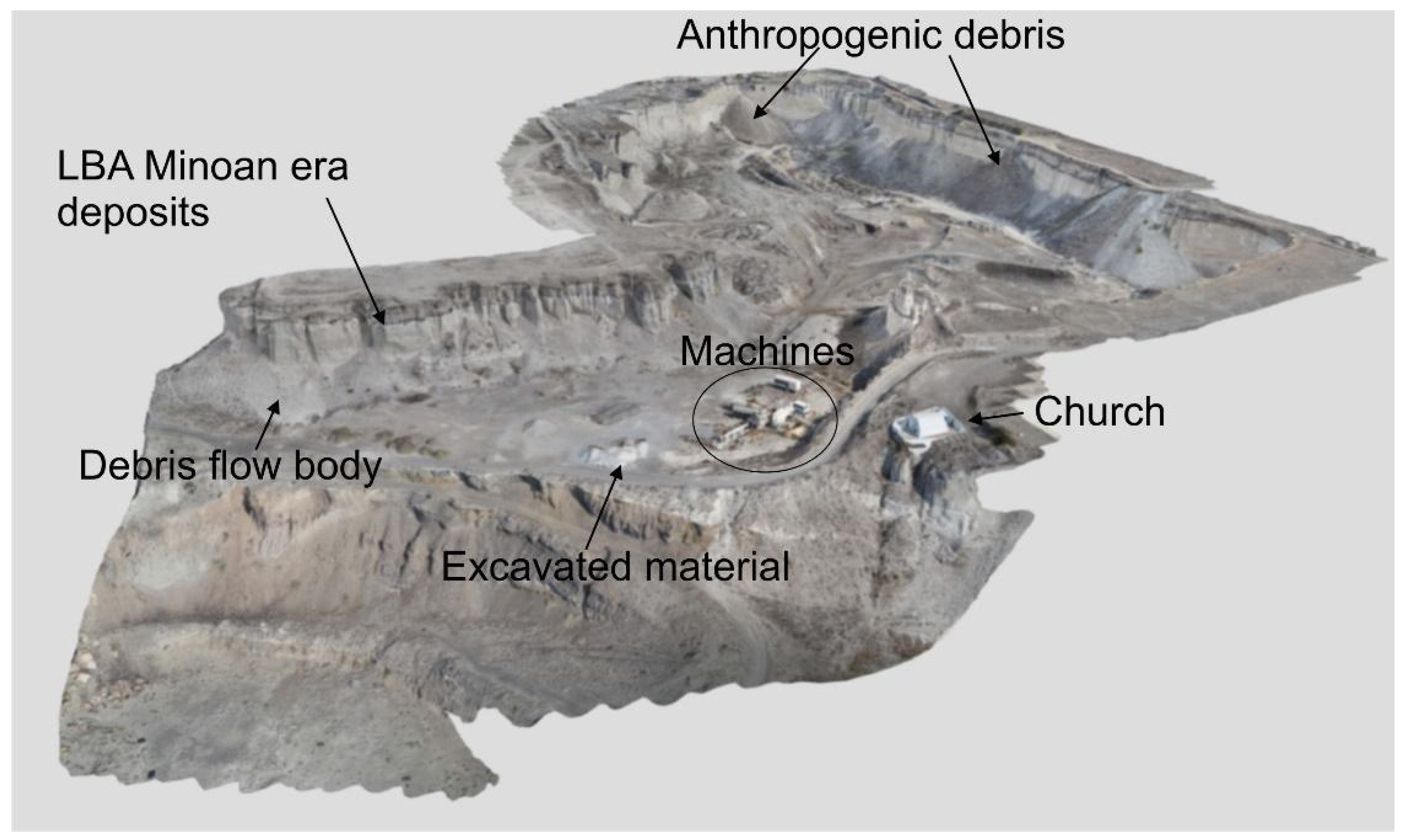
3.1. The Metaxa Mine, Santorini (Greece)

The Metaxa Mine is in the SE part of the Santorini volcanic complex, which is part of the active South Aegean Volcanic Arc. The volcanic centres extend from Sousaki and Methana (close to Central Greece) to the Nisyros-Kos islands (at the Eastern border with Turkey), with Santorini volcano being its southernmost expression. The latter is located on the Aegean microplate and is associated with recent volcano tectonic activity in the region [24]. The activity of the volcanic arc is related to the subduction of the African plate beneath the Eurasian plate [25], but locally around Santorini Island the stress field is extensional due to the slab rollback [26] and the associated regional tectonics.
The Metaxa Mine is an iconic geosite where visitors have a chance to view and explore the Late Bronze Age Minoan era deposits. Moreover, it is an industrial heritage site as the extraction of pumice during the previous century gave considerable income opportunities to the local population. Locally, the landscape presents an asymmetrical morphology [17], surrounded by almost vertical and overhanging cliffs and covered by debris flow deposits and remnants of anthropogenic activities. Its heterogeneous floor is scattered with small hills made of covered excavation materials. Along the vertical slopes of the mine, and especially at the entrance, an excellent outcrop showing Late Bronze Age deposits [5] can be observed. The virtual geosite for this site (Figure 2) has an extent of about 520 × 400 m and a texture resolution of 0.9 cm/pix. Further details are in Antoniou et al. [17] while 3D details with annotations can be found at https://geovires.unimib.it/ (accessed on 26 November 2021), within the geosites section, and at https://arcg.is/1e4erK0 (accessed on 26 November 2021).

3.2. 1984 Krafla Eruption Site, Northern Volcanic Zone (Iceland)

The virtual geosite is located within the Krafla fissure swarm in the Northern Volcanic Zone of Iceland, along the emerging part of the Mid Atlantic ridge. This unique volcano tectonic terrain is composed of active rift zones, extension fractures, faults, eruptive fissures, and basaltic volcanoes. The area is occupied by a number of volcanic craters with a N-S alignment (Figure 3), lava flows, as well as a series of extension fractures and normal faults associated with the 1984 Krafla eruption [27]. The larger cone in the foreground (350 m × 150 m) was formed in 1984, at the end of the “Krafla Fires” eruptive cycle [28]. In its central part, one can observe the pyroclastic cone flank [19] as well as two normal faults which cross the post-Latest Glacial Maximum lava flows (older than 7 ka BP; 27). In the model, a cluster of recent monogenetic volcanoes (scoria cones) is also present, as well as an older scoria cone filled by the 1984 lava flow. The virtual geosite for this site (Figure 4) has an extent of about 1010 × 680 m and a texture resolution of 2.6 cm/pix. Additional details are made available in 3D with annotations at: https://geovires.unimib.it/ (accessed on 26 November 2021), within the volcano tectonics section.

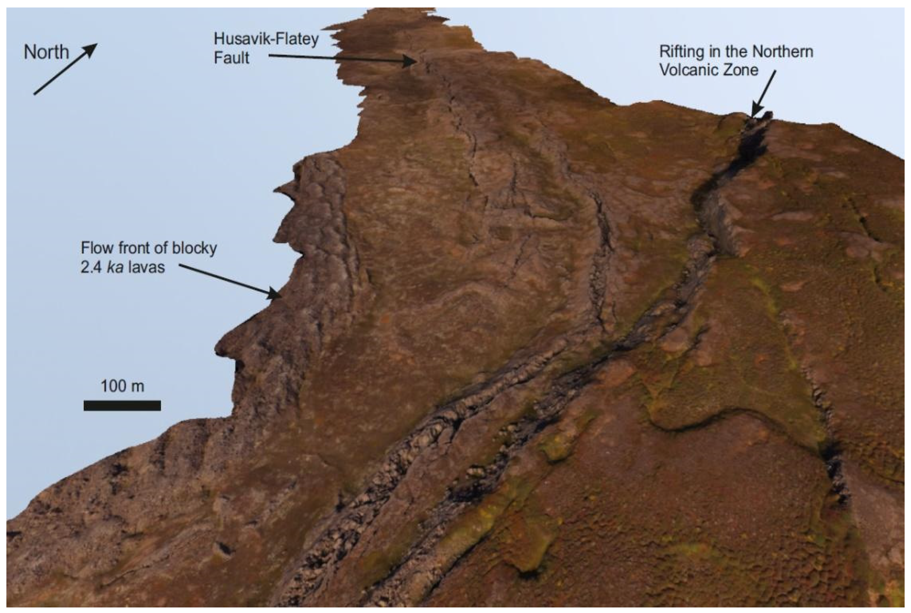
3.3. The Rift-Transform Triple Junction, Northern Volcanic Zone (Iceland)

To the east of Husavik, in Northern Iceland, a remarkable subaerial triple-junction intersection is preserved between the Husavik-Flatey Fault dextral transform fault and rifting in the Northern Volcanic Zone (Figure 4). The geomorphological and structural landforms are visible due to the presence of a sheet of pahoehoe lavas that record numerous structural features that are displayed in fantastic detail. These features include transform and extensional fault structures, riedel fault complexes, transpressional faulting and compressional strike-slip relay ramps, as well as second-order R, R’ and P shears [18], providing a unique opportunity to investigate this dynamic structural environment using a virtual reality model created from drone imagery acquired over the triple junction region for the first time. Two interacting fault systems are clearly visible in the drone data and using the VR (the drone flight mode is particularly good for viewing these structures), comprising a NW-SE transform-affinity faults of the Husavik-Flatey Fault and the roughly N-S normal faults of the Theistareykir rifting in the volcanic zone. The site is dominated by the vertical fault scarp face that extends north-south and the Husavik-Flatey Fault that extends away from this cliff face, as well as a series of small fault scarps with evidence of opening and right lateral movement.

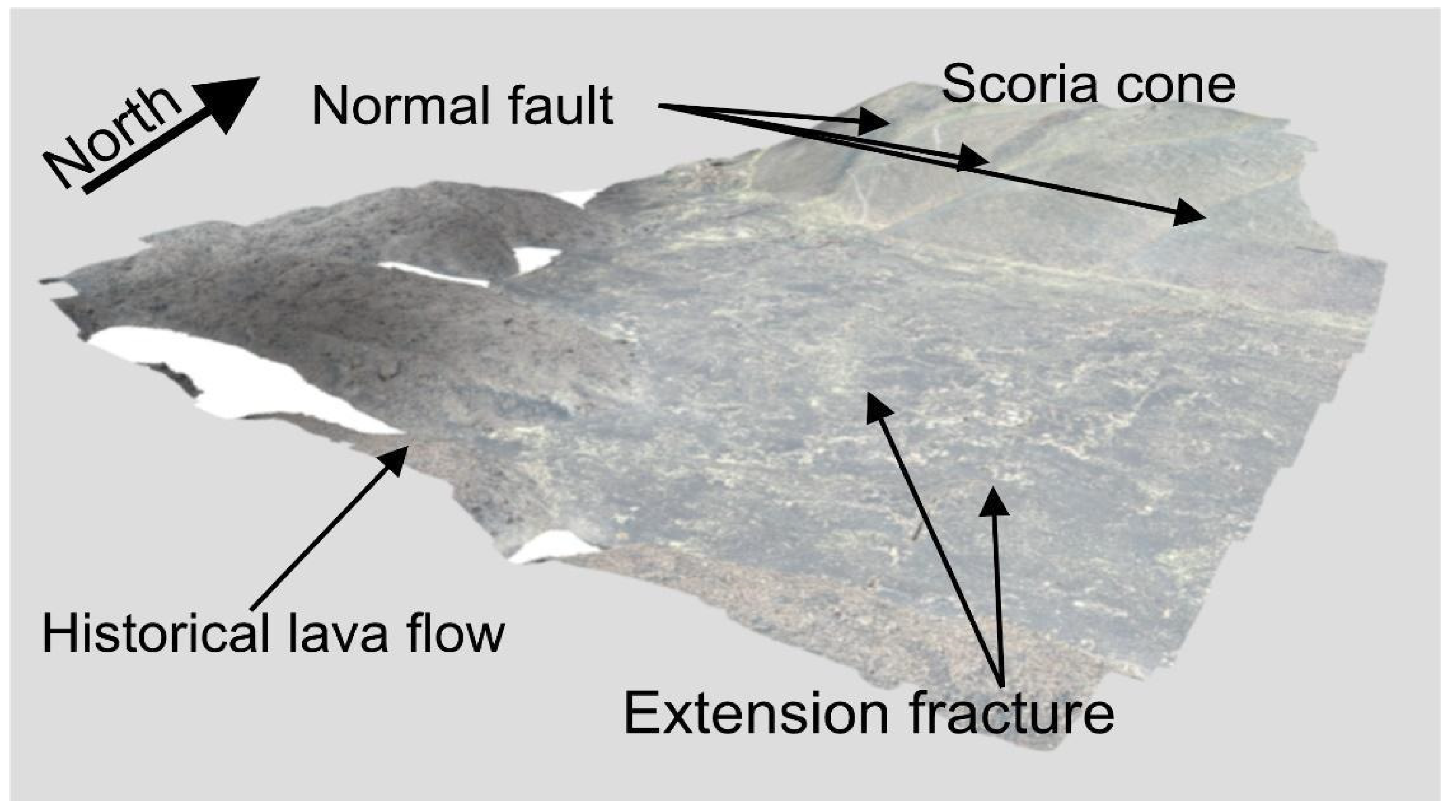
3.4. Mt Pizzillo Area, NE Rift of Mt. Etna (Italy)

Mt. Etna is located along the eastern coast of Sicily, Italy, and since 2013 it has been inscribed on the UNESCO World Heritage list. Its long eruptive history, starting from 600,000 years ago [29] and its continuous gas and vapor emissions along with its sporadic Strombolian activity, has produced several spectacular lava fountains and lava flows which make this volcano an important reference for volcanological studies. Etna is, therefore, an ideal site to test immersive virtual reality and design a virtual survey of geological and structural features, such as its dense network of eruptive fissures forming the so-called NE, S and W Rifts. In particular, the area of investigation is located in the northern sector of the volcano: it belongs to the NE Rift, a group of eruptive fissures that mark a zone of frequent, shallow volcanic intrusions. The rough terrain is affected by active deformation (approximately 2 cm/yr [30]) and is covered by cinder cones and historical lava flows. The virtual geosite (Figure 5), which has an aerial extent of about 230 × 200 m and a texture resolution of 2 cm/pix, is an area located within Mt Etna’s NE rift, on the northern flank of the volcano. Here, the users can observe a swarm of NE-SW extension fractures with centimetric dilation (up to about 70 cm) and several piercing points, which can be clearly observed along the fracture walls. The two widest main fractures gradually transit to normal faults, dipping towards each other. The faults can be clearly recognized on the flank of the pyroclastic cone of historical age [29]. The primary fracture located on the right is next to a short normal fault dipping to the left. By following the trace of the fault where it reaches the highest point on the flank, it is possible to see its partitioning into two faults that dip towards each other and form a graben structure. Further details are made available in 3D with annotations at: www.geovires.unimib.it, within the volcano tectonics section.

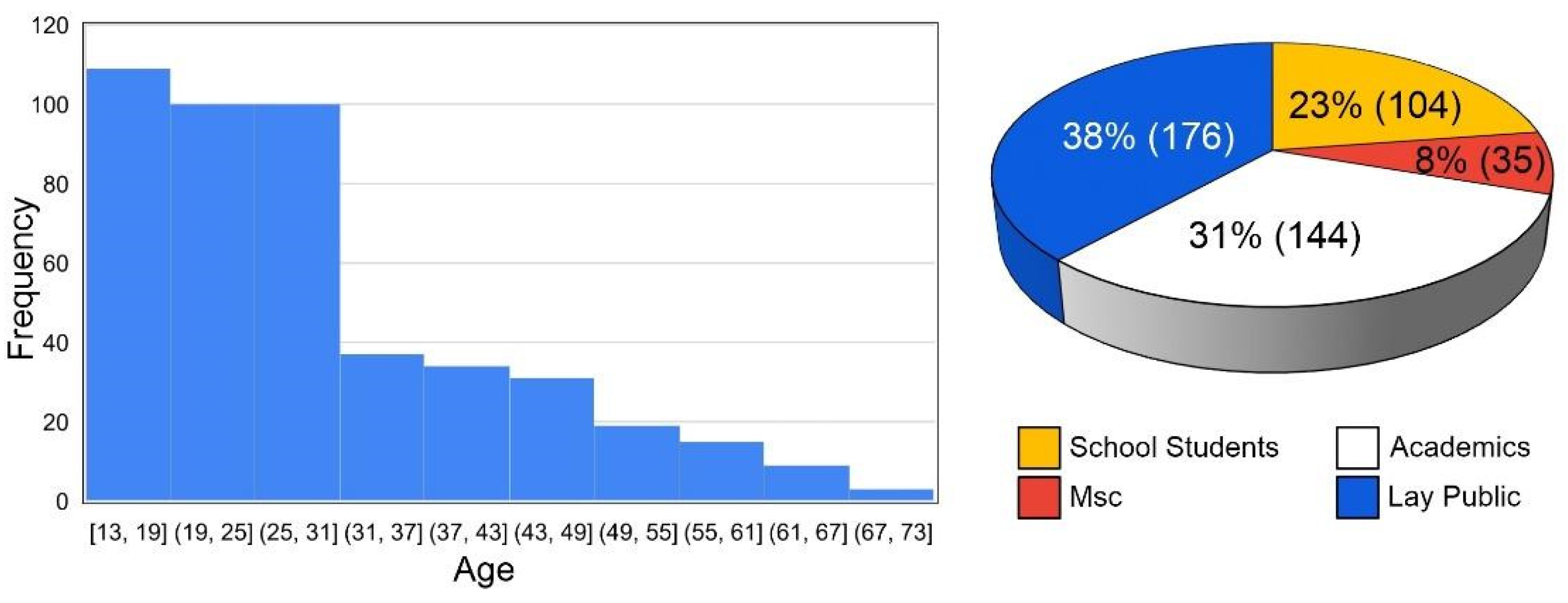
4. Feedback from the Users

In this section we show the results acquired from 459 questionnaires from participants, aged 13–73. We focus both on the entire dataset of participants and on the following categories:
(i)
Academics/researchers in Earth Sciences (A/RES) (n = 144, age 25 ÷ 70);
(ii)
MSc students in Earth Sciences (MScSES) (n = 35, age 21 ÷ 30);
(iii)
middle and high school students (MHSS) (n = 104, age 13 ÷ 20);
(iv)
Lay public (LP) (not related to the previous categories, n = 176, age 19 ÷ 73) (Figure 6). It is worth noting that 10 out of 459 users are affected by a physical disability that would hinder the hiking or trekking needed to visit these geosites in real life.

4.1. General Questions

The preliminary questions allowed us to identify the most frequent age groups that participated in the experience during our events. The histogram in Figure 6 shows that the users mainly belonged to two main groups: 13–31 years old, followed by the range between 31 and 49 years old, while older ages were less represented. For their backgrounds, the graph in Figure 6 shows that most of the users belonged to the lay public (38%), followed by academics (31%), school students (23%) and finally MSc class (age 21–30) (8%).

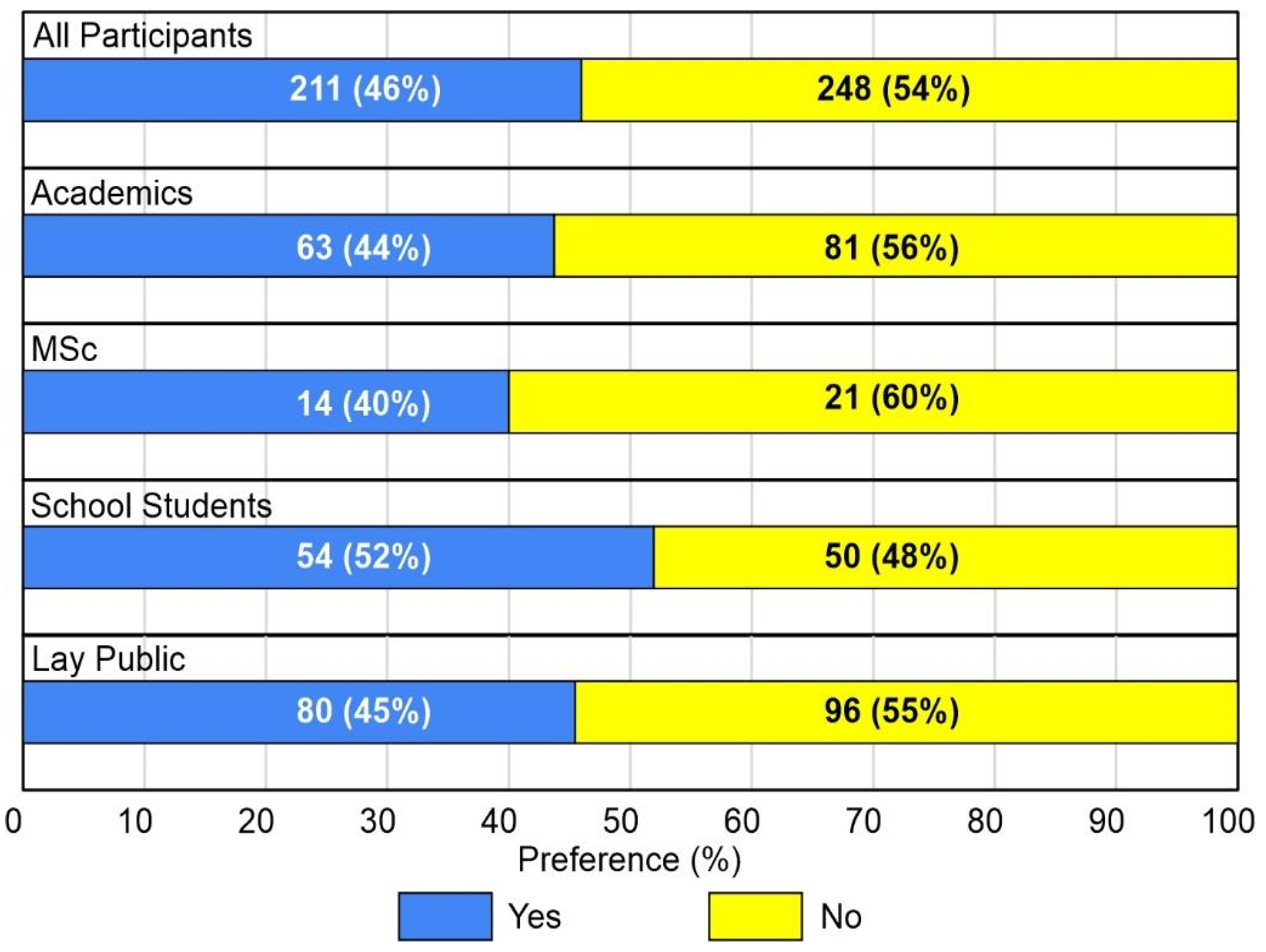
4.1.1. Have You Ever Used a VR Headset Before?

As part of their feedback, all participants were asked about their familiarity with the VR equipment before the event. The results are displayed in Figure 7 and show that the majority of the users (54%) had not used similar equipment before. This observation, however, changes if we consider each category singularly. In particular, most students (52%) ranging from 13 to 20 years old (school students) had already used a VR headset before. On the other hand, lay public and academics show similar percentages: most (55% in the former case and 56% in the latter) had not used a VR headset before the dissemination event.

4.1.2. Do You Usually Go Hiking/Trekking?

Figure 8 shows the habits of the participants with respect to hiking/trekking: most users (72% of all participants) enjoyed the direct contact with nature and thus were used to going hiking or trekking. This percentage increased when considering both academics and MSc (84% in the first case and 83% in the latter). Finally, school students (59%) and lay public (68%) also reached quite high percentages. This was a fundamental question to compare replies from two different datasets of participants that were, or were not, addicted to field excursions, thus with different levels of expertise in landscape exploration.

4.2. General Questions on Immersive Virtual Reality

4.2.1. Which Is Your Favourite Navigation Mode?

For most participants, as displayed in Figure 9, the most popular navigation mode during immersive virtual reality exploration was the drone. This was clearly shown both by considering all participants (69%) and the single categories (for which the percentage ranged from 67% to 71%). Between the other two modes, the walk and flight ones, users mostly chose the walk mode (20–21%). A discrepancy, however, was found in the results provided by the MSc group, who showed a slight preference for the flight mode (17%) over the walk mode (14%).

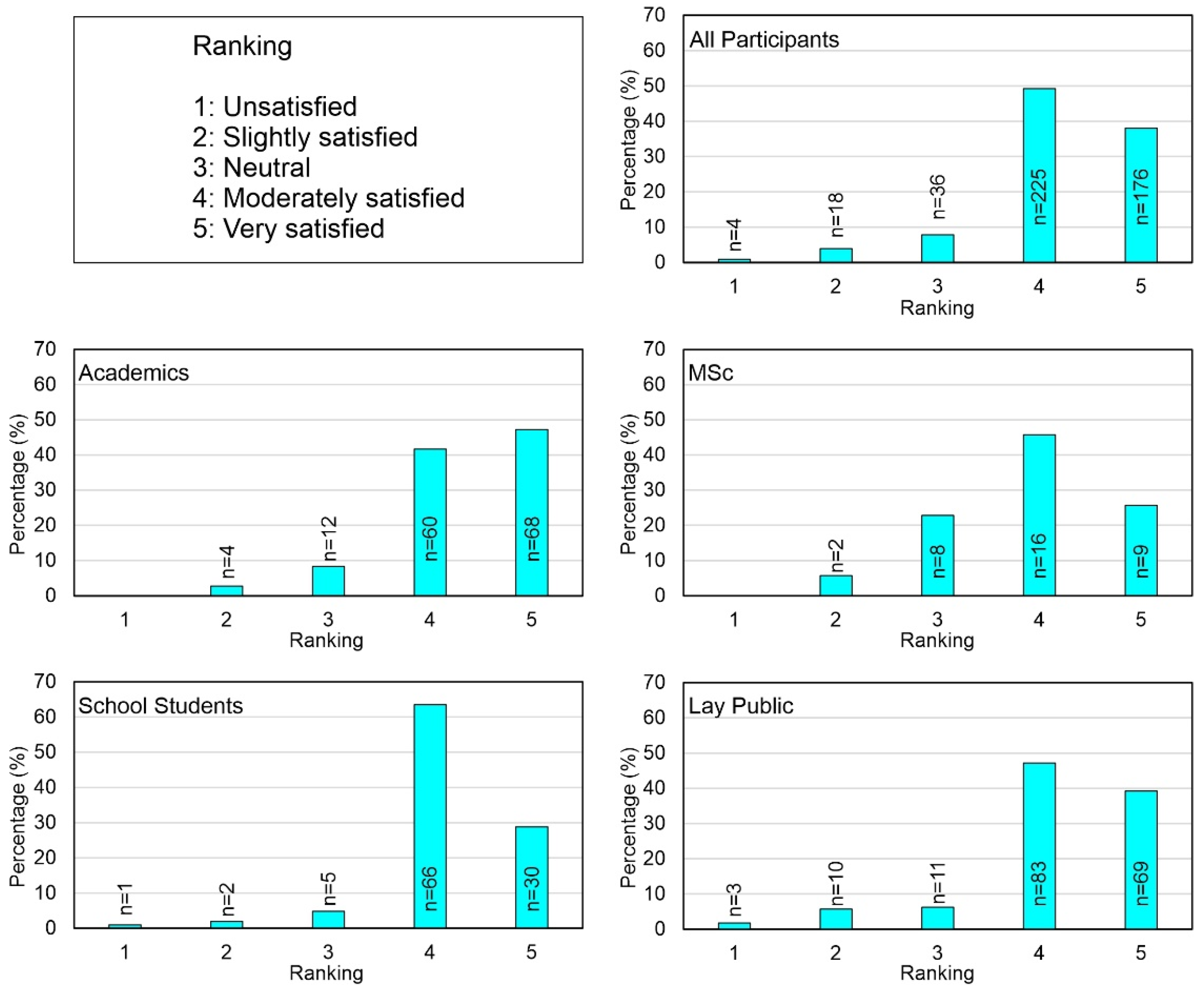
4.2.2. How Satisfied Are You with the Portrayal of the Virtual Landscape?

The users’ satisfaction on the portrayal of the immersive VR environments showed that most declared themselves to be moderately (49%) to very satisfied (38%) (Figure 10), with the academics as the most satisfied (47%), followed by the lay public and MSc. The data for school students showed the lowest satisfaction rate for rank 5, even though the majority responded 4 and 5.

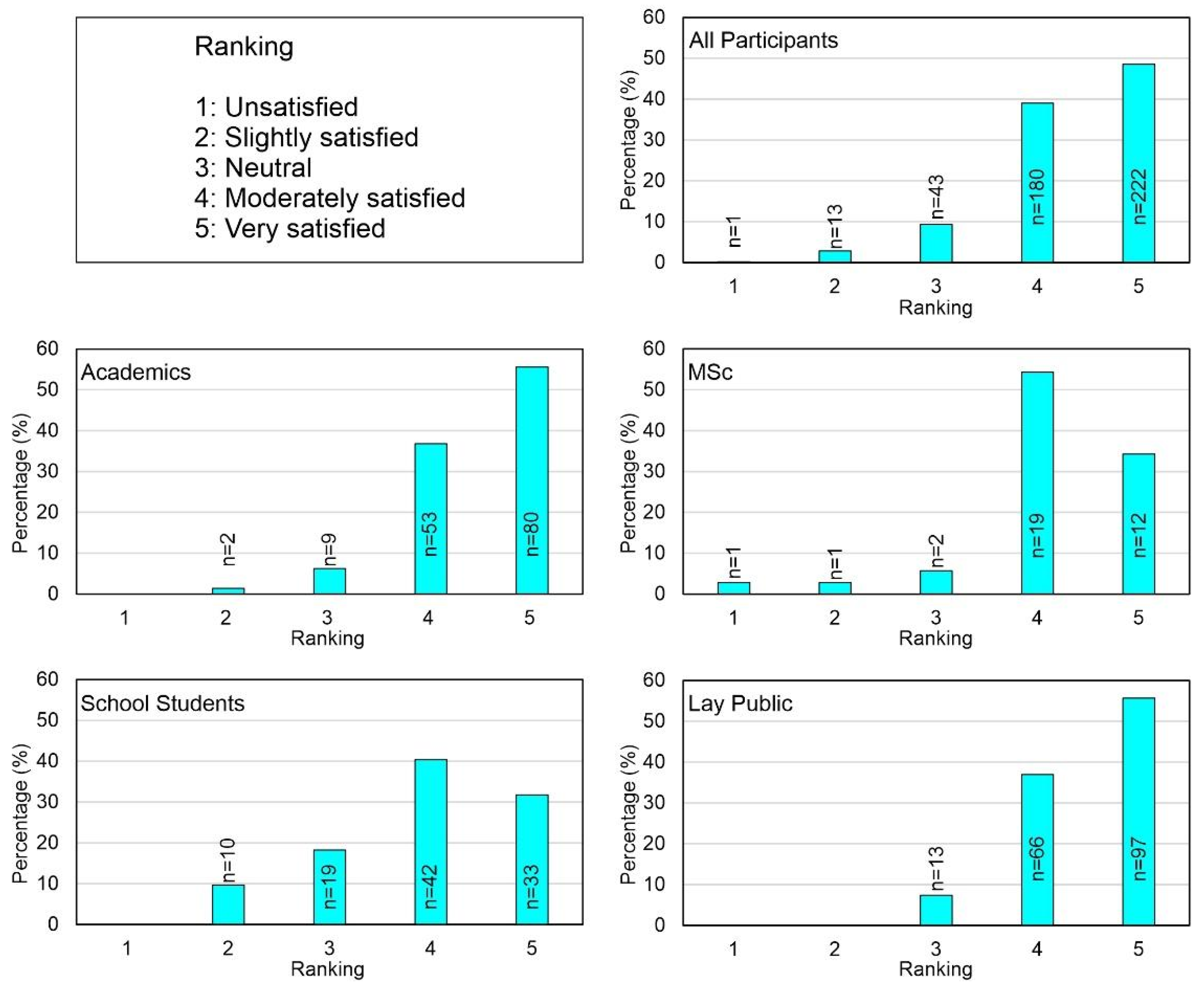
4.2.3. How Would You Rank Your Experience with Virtual Exploration?

More feedback was collected about the general satisfaction of the participants with the immersive virtual reality exploration. Most users were moderately to very satisfied with their experience (Figure 11). The highest percentages were shown by academics and the lay public. Based on our statistical analysis, school students were a little bit less satisfied when compared with the other categories. In fact, 18% declared themselves to be basically neutral.

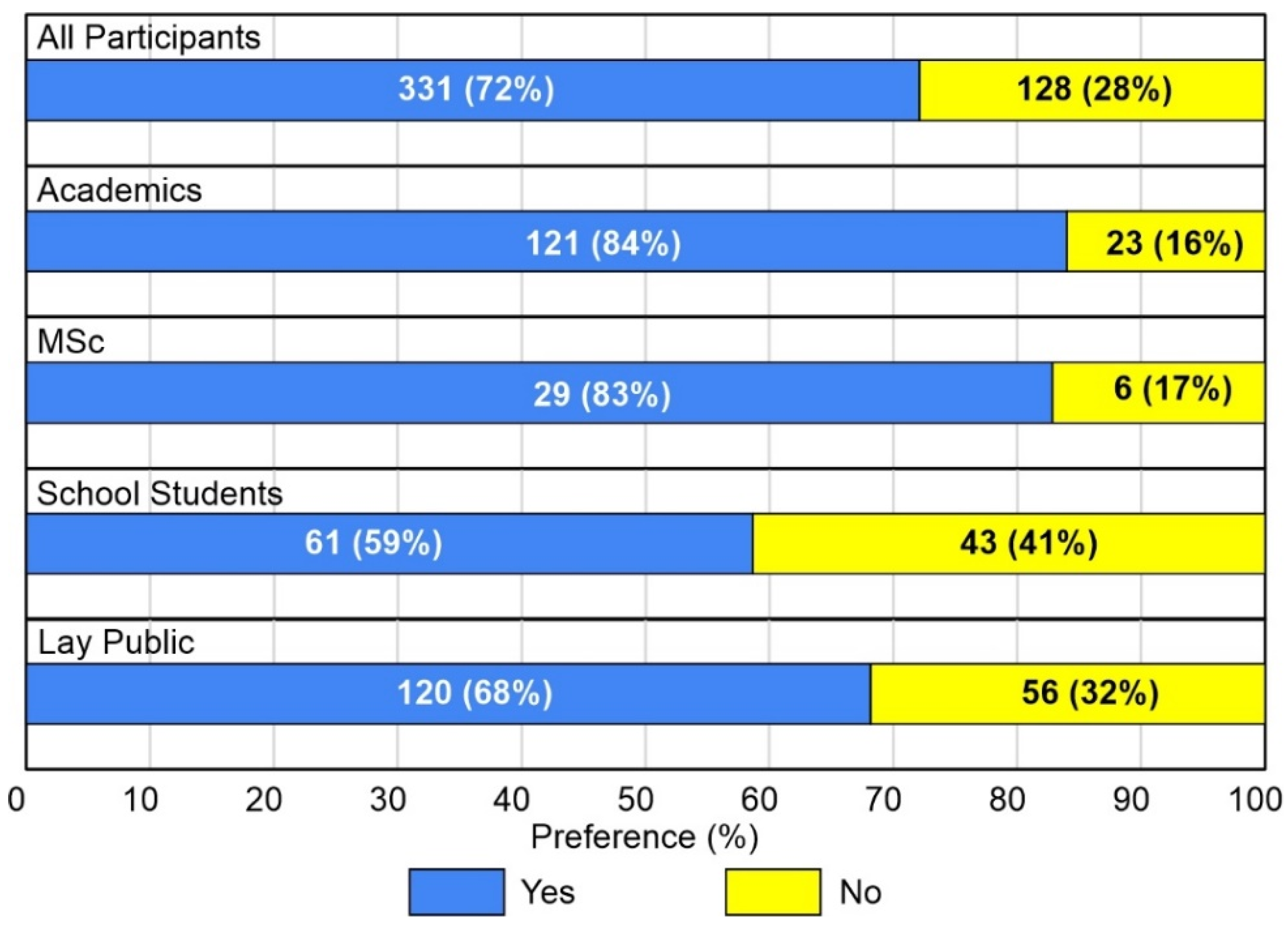
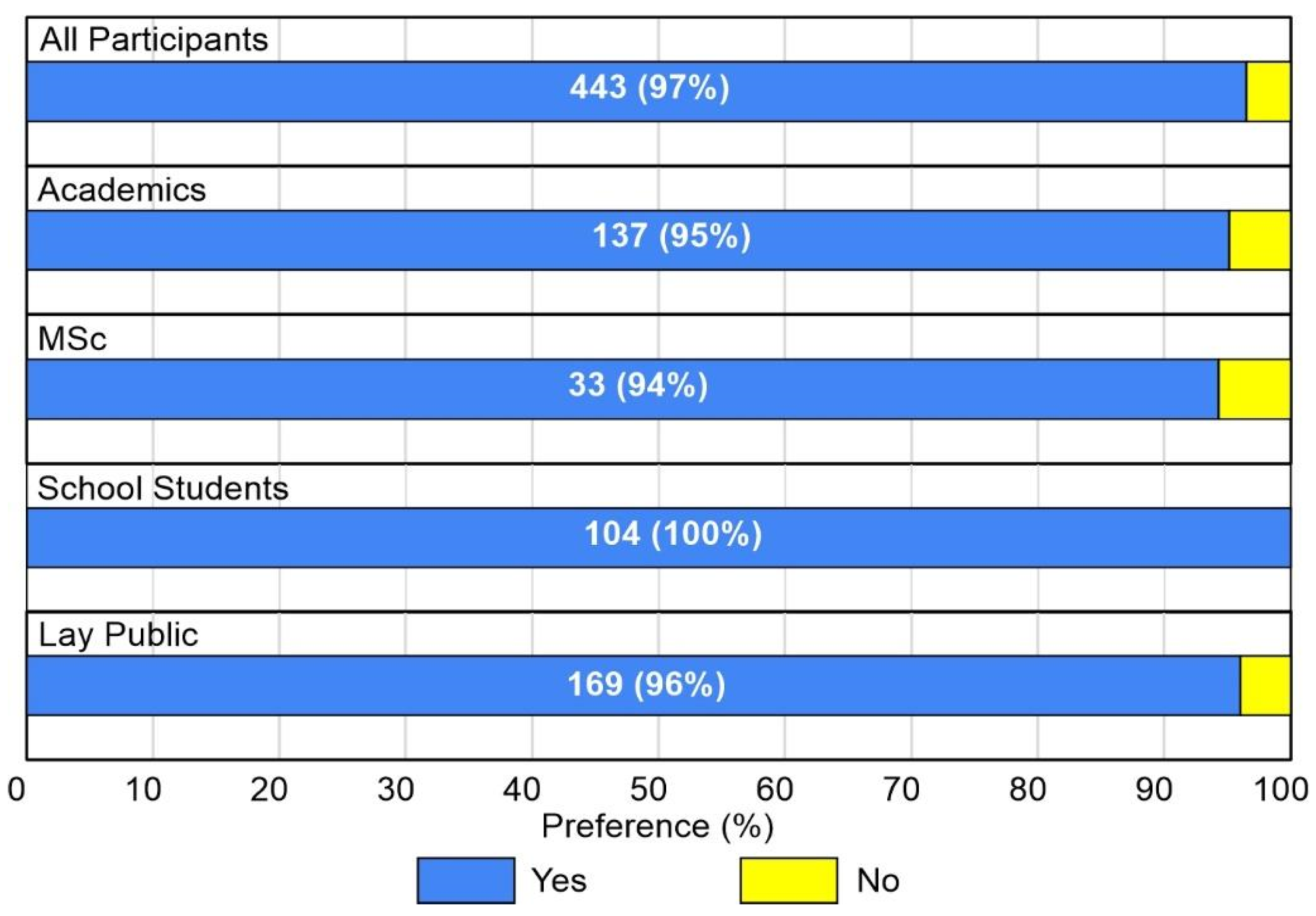
4.2.4. Would You like to Repeat the Experience?

Based on our results, a high percentage of the users wanted to repeat the experience (Figure 12). In fact, an average of 97% of all participants definitely wanted to repeat the experience; The school students category scored 100%.

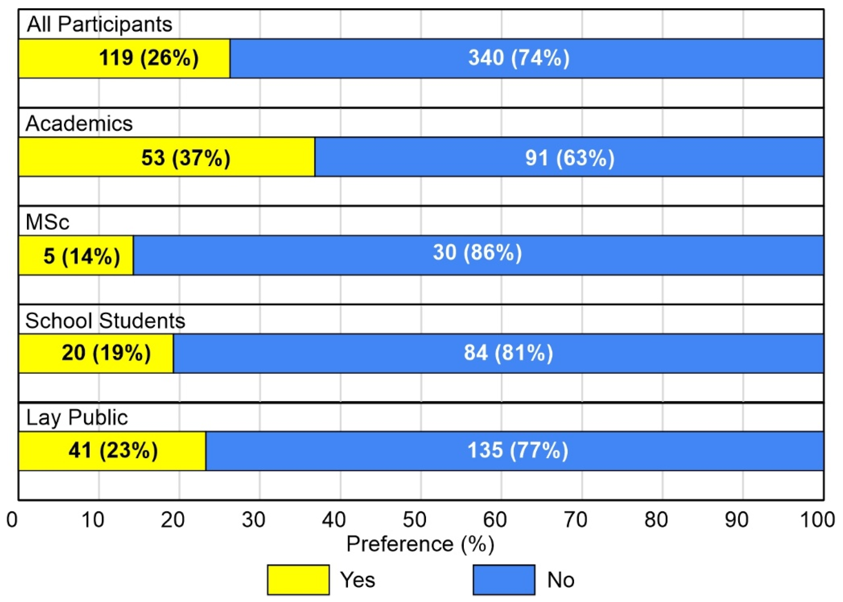
4.2.5. Did You Experience Any Form of Physical Sickness during the Navigation? If so, Which One?

Short-term sickness was mentioned by 26% of the participants (Figure 13). This varied across the different groups, with academics being the most impacted, and MSc and school students being the least impacted. The overall 119 sickness effects reported consisted of: slight dizziness (65%), slight headache (22%), slight nausea (10%) and disorientation (3%). None resulted in an interruption of the experience, suggesting that these effects are minor in most cases. Regarding this point, we are aware that there are more thorough, systematic, and validated ways of evaluating the feeling of sickness due to the usage of VR technologies (in particular the Simulator Sickness Questionnaire—SSQ—introduced by Kennedy et al. [31]), but we only wanted to have an at-a-glance indication about the fact that some adverse effects were perceived by the users, and also to evaluate the real need of performing additional experiments on this point.

4.3. Teaching

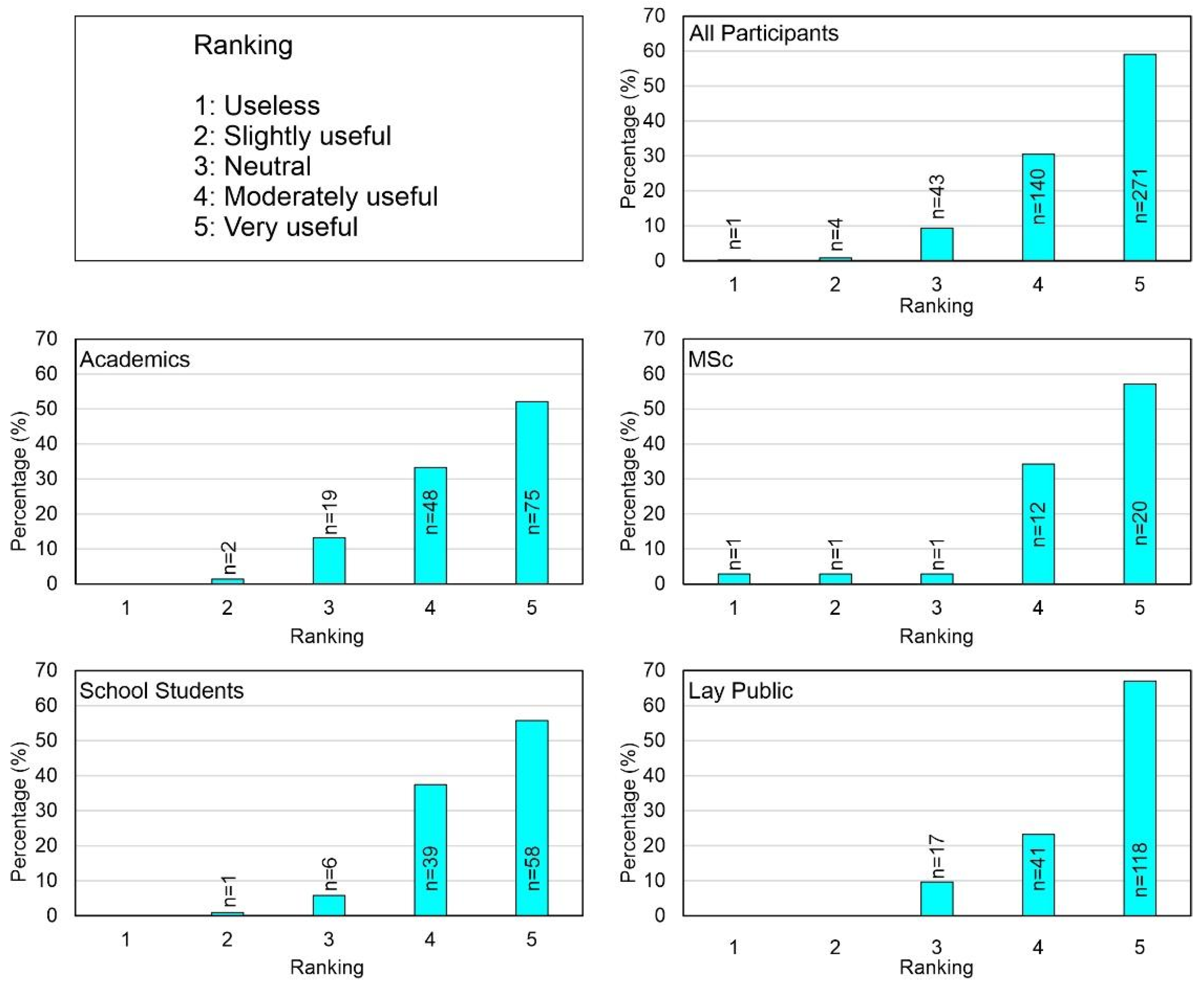
4.3.1. How Useful Do You Think Immersive Virtual Reality Is as a Studying/Learning Tool in Earth Sciences?

Figure 14 shows the effectiveness of immersive virtual reality as a learning tool. All participants believed that it could be very useful (59%) followed by moderately useful (30%). When considering each category, the perception of the users remained very similar. In particular, the lay public was found to be the most enthusiastic, as 67% found it ‘very useful’. The other categories recognized the potential of this technology as a learning instrument. In particular, 56% of the school students and 57% of the MSc agreed with this scenario. Academics were less fond of it: 52% provided a very positive opinion, but 13% remained neutral.

4.3.2. How Useful Do You Think Immersive Virtual Reality Is as a Teaching Tool in Earth Sciences?

The great majority of the users (68%) declared that immersive virtual reality can be effectively used as a geo-education tool (Figure 15). In detail, academics and MSc showed similar results (70% and 69%, respectively) and found this possibility very promising. In contrast, school students only believed that it was ‘very useful’ at 52%, offering a general positive opinion when the ‘moderately useful’ replies, totalling 95%, were considered.

5. Discussion

Overall, the results of our initiative of using immersive virtual reality as a tool to carry out dissemination events on geo-education has been very positive. We held nine events, in three different countries, both in Italian and English languages, engaging a total of 459 international participants from various backgrounds. All dissemination events were carried out with the same format, virtual geosites and holistic view, aimed at understanding the impact of VR experiences on geosciences. Such events also involved people affected by temporal, or permanent, motor disabilities, who could explore “in person” inaccessible sites, proving how this technology could provide equality when dealing with geological field work and exploration. Thanks to the feedback given by all participants collected during these events, we provided a quantitative assessment of the immersive virtual reality experience, to evaluate its applicability as a tool for virtual geological exploration, with a particular focus on geo-education and communication. This represents an additional value, since previous attempts to evaluate VR techniques applied to Earth Sciences were mainly qualitative.
Generally speaking, there is a general agreement in the literature, mainly by practice and qualitative evaluations, that VR techniques are useful for teaching, as well as for learning in Earth Sciences (e.g., [7,8,9]). Over the last decade, several low-cost solutions have been made available to enable a quick and easy immersive virtual reality experience, both in terms of hardware and software solutions [32,33,34], providing teachers, students, and researchers with innovative tools to be applied in Earth Sciences. So far, in 2002, Kaiser et al. [32] applied immersive VR technology to improve mine planning, thanks to a collaboration among scientists with different areas of expertise. Recently, Kinsland and Borst [35] successfully used such technology to visualize geological data as 3D objects to be managed by scientists. As regards geo-education and research activity, McNamee and Bogert [36] started using immersive virtual reality through a commercial application that allows users to fly and walk in a virtual scenario, in order to address two of the main problems in teaching geological processes in an introduction-level physical geology course: describing dimensions and scale. A slightly different approach has been used by Visneskie et al. [37], where the immersive experience was conducted with a set of 360-VR-Videos organized as a virtual tour to be used with mobile headsets. At a more advanced level, Tibaldi et al. [5], Antoniou et al. [17] and Caravaca et al. [38] designed a system where the user is capable of moving within a georeferenced and scaled 3D scene that can be explored simulating a real field trip.
Following this general view that VR tools are useful for geo-education and research activities in Earth Sciences, we aim to contribute to the discussion with a new relevant quantitative evaluation on the immersive virtual reality system developed by Tibaldi et al. [5] and many of the authors of the present paper, and successively applied for use in research activity by Antoniou et al. [17].
In evaluating the replies to the questionnaires, the first important output was that most participants would be glad to repeat the experience. This held for at least 97% of the respondents (all participants), with 100% positive replies provided by school students (Figure 12). More in detail, 96% of the participants, who had never used a VR headset before, would be willing to repeat the experience, whereas for those who had already tried a VR headset, the percentage rose to 98%.
For the exploration mode, most participants preferred to fly in “drone mode”, around and above the main geological objects within the virtual geosites (Figure 9), by a percentage always greater than 67%, with the highest being reached by the lay public (71%), and a greater appreciation from participants that had already used VR (75%), when compared to those who had experienced it for the first time (64%). In addition, when considering if users were used to hiking or not, the drone mode reached a percentage of 68% and 71%, respectively, confirming that this was the best choice for navigation.
Another important aspect pertains to the type of virtual scenario we have proposed: again, in this case, the majority of participants ranked with high marks (4–5) the portrayal of the virtual landscape (87%), which is based on drone-captured pictures. This appreciation rate came especially from the lay public (86%), academics (89%), and school students (92%); on the other hand, the percentage of MSc was 71% (Figure 10).
The above results confirm the general appreciation for a photogrammetry-based virtual scenario. The results acquired from school students are the most interesting. Indeed, they show the lowest satisfaction for rank 5, even though the majority responded 4 and 5. We think that this could be due to the fact that school students are far more used to gaming and hyper real visualisations than other categories: as a consequence, their expectations might probably be higher. An improvement that can be made to the virtual landscape, for a better application to geo-education, is the possibility of adding everyday scaled objects to the scene, to help the user better perceive dimensions and distances. This approach could help overcome distance underestimation problems in VR compared to reality [39,40].
For the overall evaluation of the exploration of volcanic areas through the system, with the support of a geo-expert, the majority of the participants ranked with high value (4–5) the experience (87%), reaching a percentage of 93% among the lay public, 92% among academics, 88% among MSc, whereas the percentage plummeted to 72% for school students (Figure 11).
For the use of immersive virtual reality as a tool for studying and teaching Earth Sciences, it is worth noting that these questions have a different importance for academics than for both the student categories (MSc and school students). For the former group, both teaching and studying dimensions are relevant: in terms of studying activities, it is interpreted as an application to study landscapes, and thus as an application for research purposes as they are allowed to make direct observations. For MSc and school students, it is the studying/learning question that has a greater importance, since it would be applied as a tool for advanced learning activity. Regarding the results of these questions, as shown in Figure 14 and Figure 15, there is a general appreciation from all groups, with percentages in the range 85–96%: particularly, immersive virtual reality is considered as a great study instrument by 85–93% of the sample; the geo-education potential of it is highly regarded by 89–96% of the sample; in this latter case, the highest value (5) dominates the replies (Figure 15).
Some participants suffered from sickness effects, but none stopped the experience, and among those affected by sickness effects, only 8% of this subset would not like to repeat the experience, corresponding to about 2% of the total, suggesting that educational VR applications still need to be slightly improved. The latter point could be further explored through more detailed analyses on perceived adverse effects and system usability, following Vizzari [41]’s approach. It is noted that in order to achieve this, it is necessary to focus on a smaller number of participants, in ad hoc events lasting longer, with specific tasks being carried out, and that this is out of the scope of the present work. From a technical point of view, the use of VR headsets capable of working with a frame per second value higher than 90 can help reduce sickness effects [42]. In addition to that, it can be suggested that the user repeat the experience a few minutes after the first test. In fact, based on our personal experience, the more frequently immersive virtual reality systems are used, the more comfortable users become with the VR experience.
Overall, our results demonstrate and confirm the great potential of immersive virtual reality for geo-education and as a tool for geoscience communication to citizens, with possible applications for geotourism. Students, academics, and non-academics can explore virtual geosites in person, acquiring geological knowledge without temporal or spatial limitations, potentially reducing travel costs and carbon emissions [43], and decreasing unnecessary energy consumption.
The most important and innovative benefits we consider regarding the use of Immersive VR can be summed up as follows:
(i)
It has a great potential to help users learn geology in a more interactive way, enhancing interest and improving learning efficiency, even if geological field trips are still crucial for a better understanding of Earth Science processes;
(ii)
It can open up the possibility of studying virtual geosites in person for people affected by motor disabilities; it is worth noting that all participants belonging to this category ranked all questions with values greater than 4 and wished to repeat the experience in the future;
(iii)
It implies a relevant cost cutting, especially for students, since geological outcrops can be brought into the lab;
(iv)
It can be considered as an approach to reduce carbon emissions, due to the decrease in travelling needs for many people;
(v)
It allows researchers to virtually travel to key geological spots and do science even in abnormal times, such as the COVID-19 pandemic.
Furthermore, immersive virtual reality can be also used by students to examine the geology field route beforehand, so as to make the trip easier and more efficient. It allows users to carry out tasks that could be difficult in the real world due to constraints and restrictions, such as cost, scheduling, or location. Immersive virtual reality can be an alternative plan for field trip teaching in case the actual field trip cannot be conducted, or before scheduling a field trip to better plan the survey of the area.
We wish to highlight that both VR and immersive VR tools are especially crucial nowadays to overcome limitations due to travel restrictions and lockdown periods aimed at containing the COVID-19 pandemic, which have especially affected Earth Science teaching and research activities. In fact, teaching usually entails field activities with the involvement of large student groups and research activities often need field surveying in foreign countries. For both, the use of VR can also reduce the carbon imprint of education and research.

6. Conclusions

Our work has been focused on the quantitative evaluation of the participation of different types of people in immersive virtual reality experiences dedicated to Earth Sciences, especially volcanic areas. Our quantitative survey has involved a total of 459 questionnaires, filled in by participants at nine events between 2018 and 2019. The geological sites selected for the experience are located in Greece (Santorini), North Iceland and Italy (Mt. Etna).
The analysis of the questionnaires, based on nine questions, has enabled us to shed light on how useful this approach is for geo-education purposes. The majority of the respondents have shown a high degree of interest in the immersive experience. They particularly appreciated the opportunity to fly like a drone over the displayed geological objects. Another key outcome of the survey is the respondents’ major satisfaction with the portrayal of the environment, made possible by cutting-edge, unmanned aerial system (UAS)-based photogrammetry techniques.
Importantly, 97% of the participants wished to repeat the experience.
With regard to the geo-education potential of this technique, most participants ranked with high value (4–5) the experience (94%), reaching a percentage of 96% among academics in Earth Sciences. Therefore, this study confirms that both students and academics see VR as a useful tool for geo-education.
Furthermore, our data shows the important role that immersive VR might have as a tool for:
(i)
popularizing Earth Sciences teaching and research by making geological key areas available to the public in terms of 3D models and scientific explanations of geological processes;
(ii)
including people affected by motor disabilities who would not have access to dangerous/remote areas (e.g., tectonically or volcanically active) otherwise.
Based on the above considerations, immersive VR can be also regarded as a groundbreaking tool to improve democratic ways to access information and experience, as well as to promote inclusivity and accessibility in geo-education while reducing travel, saving time, and carbon footprints.

Author Contributions

F.L.B. has tailored and managed all the events as well as organized and written the manuscript. E.R., F.V., V.A., F.M., L.F., V.B., N.C., A.S., M.W., K.D., F.P.M., P.N., E.S., S.B., S.F., D.R., B.v.W.d.V., M.K., G.P., M.A.S.-R., G.V., U.B. and A.T. have participated in the events and contributed to writing the manuscript. All authors have read and agreed to the published version of the manuscript.

Funding

This research received no external funding devoted to this specific research.

Informed Consent Statement

Not applicable.

Data Availability Statement

The dataset with the replies from the participants is available online at https://doi.org/10.5281/zenodo.5792209 (accessed on 26 November 2021).

Acknowledgments

This research has been provided in the framework of the following projects: (i) the MIUR project ACPR15T4_00098–Argo3D (http://argo3d.unimib.it/ (accessed on 26 November 2021)); (ii) 3DTeLC Erasmus + Project 2017-1-UK01-KA203-036719 (http://www.3dtelc.com (accessed on 26 November 2021)); (iii) EGU 2018 Public Engagement Grant (https://www.egu.eu/outreach/peg/ (accessed on 26 November 2021)). Agisoft Metashape is acknowledged for photogrammetric data processing. This article is also an outcome of Project MIUR–Dipartimenti di Eccellenza 2018–2022. Finally, this paper is an outcome of the Virtual Reality lab for Earth Sciences—GeoVires lab (https://geovires.unimib.it/ (accessed on 26 November 2021)). The work supports UNESCO IGCP 692 ‘Geoheritage for Resilience’.

Conflicts of Interest

The authors declare no conflict of interest.

References

  1. Trinks, I.; Clegg, P.; McCaffrey, K.; Jones, R.; Hobbs, R.; Holdsworth, B.; Holliman, N.; Imber, J.; Waggott, S.; Wilson, R. Mapping and analysing virtual outcrops. Visual Geosci. 2005, 10, 13–19. [Google Scholar] [CrossRef]
  2. Edler, D.; Keil, J.; Wiedenlübbert, T.; Sossna, M.; Kühne, O.; Dickmann, F. Immersive VR Experience of Redeveloped Post-Industrial Sites: The Example of “Zeche Holland” in Bochum-Wattenscheid. J. Cartogr. Geogr. Inf. 2019, 69, 267–284. [Google Scholar] [CrossRef]
  3. Pasquaré Mariotto, F.; Bonali, F.L. Virtual Geosites as Innovative Tools for Geoheritage Popularization: A Case Study from Eastern Iceland. Geosciences 2021, 11, 149. [Google Scholar] [CrossRef]
  4. Lütjens, M.; Kersten, T.; Dorschel, B.; Tschirschwitz, F. Virtual Reality in Cartography: Immersive 3D Visualization of the Arctic Clyde Inlet (Canada) Using Digital Elevation Models and Bathymetric Data. MTI 2019, 3, 9. [Google Scholar] [CrossRef]
  5. Tibaldi, A.; Bonali, F.L.; Vitello, F.; Delage, E.; Nomikou, P.; Antoniou, V.; Becciani, U.; Van Wyk de Vries, B.; Krokos, M.; Whitworth, M. Real world–based immersive Virtual Reality for research, teaching and communication in volcanology. Bull. Volcanol. 2020, 82, 38. [Google Scholar] [CrossRef]
  6. Krokos, M.; Bonali, F.L.; Vitello, F.; Varvara, A.; Becciani, U.; Russo, E.; Marchese, F.; Fallati, L.; Nomikou, P.; Kearl, M.; et al. Workflows for virtual reality visualisation and navigation scenarios in earth sciences. In Proceedings of the 5th International Conference on Geographical Information Systems Theory, Applications and Management, Heraklion, Crete, Greece, 3–5 May 2019; SciTePress: Setùbal, Portugal, 2019; pp. 297–304. [Google Scholar]
  7. Hurst, S.D. Use of “virtual” field trips in teaching introductory geology. Comput. Geosci. 1998, 24, 653–658. [Google Scholar] [CrossRef]
  8. Warne, M.; Owies, D.; McNolty, G. Exploration of a first year university multimedia module on field geology. In Proceedings of the Beyond the Comfort Zone: Proceedings of the 21st ASCILITE Conference, Perth, Australia, 5–8 December 2004; ASCILITE: Tugun, Australia, 2004; pp. 924–933. [Google Scholar]
  9. Deng, C.; Zhou, Z.; Li, W.; Hou, B. A panoramic geology field trip system using image-based rendering. In Proceedings of the 2016 IEEE 40th Annual Computer Software and Applications Conference (COMPSAC), Atlanta, GA, USA, 10–14 June 2016; IEEE: Piscataway, NJ, USA; Volume 2, pp. 264–268. [Google Scholar]
  10. Hilde, T.W.C.; Carlson, R.L.; Devall, P.; Moore, J.; Alleman, P.; Sonnier, C.J.; Lee, M.C.; Herrick, C.N.; Kue, C.W. [TAMU]2-Texas A&M University and topography and acoustic mapping undersea system. In Proceedings of the Oceans 91, New York, NY, USA, 1–3 October 1991; Volume 1, pp. 750–755. [Google Scholar]
  11. Anderson, D.M. Seafloor mapping, imaging and characterization from [TAMU]2 side-scan sonar data sets: Database management. In Proceedings of the International Symposium on Spectral Sensing Research, Maui, HI, USA, 15–20 November 1992; Volume 2, pp. 737–742. [Google Scholar]
  12. Anderson, D.M. Glacial features observed in the Elysium Region of Mars. In Proceedings of the Tenth Thematic Conference on Geologic Remote Sensing, San Antonio, TX, USA, 9–12 May 1994; pp. I-263–I-273. [Google Scholar]
  13. Martínez-Graña, A.M.; Goy, J.L.; Cimarra, C.A. A virtual tour of geological heritage: Valourising geodiversity using Google Earth and QR code. Comput. Geosci. 2013, 61, 83–93. [Google Scholar] [CrossRef]
  14. McCaffrey, K.J.W.; Hodgetts, D.; Howell, J.; Hunt, D.; Imber, J.; Jones, R.R.; Tomasso, M.; Thurmond, J.; Viseur, S. Virtual fieldtrips for petroleum geoscientists. In Geological Society, London, Petroleum Geology Conference Series; Geological Society of London: London, UK; Volume 7, pp. 19–26.
  15. Mariotto, F.P.; Antoniou, V.; Drymoni, K.; Bonali, F.; Nomikou, P.; Fallati, L.; Karatzaferis, O.; Vlasopoulos, O. Virtual Geosite Communication through a WebGIS Platform: A Case Study from Santorini Island (Greece). Appl. Sci. 2021, 11, 5466. [Google Scholar] [CrossRef]
  16. Chang, S.C.; Hsu, T.C.; Jong, M.S.Y. Integration of the peer assessment approach with a virtual reality design system for learning earth science. Comput. Educ. 2020, 146, 103758. [Google Scholar] [CrossRef]
  17. Antoniou, V.; Bonali, F.L.; Nomikou, P.; Tibaldi, A.; Melissinos, P.; Mariotto, F.P.; Vitello, F.R.; Krokos, M.; Whitworth, M. Integrating Virtual Reality and GIS Tools for Geological Mapping, Data Collection and Analysis: An Example from the Metaxa Mine, Santorini (Greece). Appl. Sci. 2020, 10, 8317. [Google Scholar] [CrossRef]
  18. Rust, D.; Whitworth, M. A unique ~12 ka subaerial record of rift-transform triple-junction tectonics, NE Iceland. Sci. Rep. 2019, 9, 9669. [Google Scholar] [CrossRef]
  19. Pasquaré Mariotto, F.; Bonali, F.L.; Venturini, C. Iceland, an open-air museum for geoheritage and Earth science communication purposes. Resources 2020, 9, 14. [Google Scholar] [CrossRef]
  20. Tibaldi, A.; Corti, N.; De Beni, E.; Bonali, F.L.; Falsaperla, S.; Langer, H.; Neri, M.; Cantarero, M.; Reitano, D.; Fallati, L. Mapping and evaluating kinematics and the stress and strain field at active faults and fissures: A comparison between field and drone data at the NE rift, Mt Etna (Italy). Solid Earth 2021, 12, 801–816. [Google Scholar] [CrossRef]
  21. Choi, D.H.; Dailey-Hebert, A.; Estes, J.S. Emerging Tools and Applications of Virtual Reality in Education; Choi, D.H., Dailey-Hebert, A., Estes, J.S., Eds.; Information Science Reference: Hershey, PA, USA, 2016. [Google Scholar]
  22. Gerloni, I.G.; Carchiolo, V.; Vitello, F.R.; Sciacca, E.; Becciani, U.; Costa, A.; Riggi, S.; Bonali, F.L.; Russo, E.; Fallati, L.; et al. Immersive virtual reality for earth sciences. In Proceedings of the 2018 Federated Conference on Computer Science and In-formation Systems (FedCSIS), Poznan, Poland, 9–12 September 2018; IEEE: Piscataway, NJ, USA; pp. 527–534. [Google Scholar]
  23. Kalawsky, R.S. VRUSE—A computerised diagnostic tool: For usability evaluation of virtual/synthetic environment systems. Appl. Ergon. 1999, 30, 11–25. [Google Scholar] [CrossRef]
  24. Browning, J.; Drymoni, K.; Gudmundsson, A. Forecasting magma-chamber rupture at Santorini volcano, Greece. Sci. Rep. 2015, 5, 15785. [Google Scholar] [CrossRef] [PubMed]
  25. Le Pichon, X.; Angelier, J. The Hellenic arc and trench system: A key to the neotectonic evolution of the eastern Mediter-ranean area. Tectonophysics 1979, 60, 1–42. [Google Scholar] [CrossRef]
  26. Brun, J.P.; Faccenna, C.; Gueydan, F.; Sokoutis, D.; Philippon, M.; Kydonakis, K.; Gorini, C. Effects of slab rollback acceleration on Aegean extension. Bull. Geol. Soc. 2017, 50, 5–23. [Google Scholar] [CrossRef]
  27. Saemundsson, K.; Hjartarson, A.; Kaldal, I.; Sigurgeirsson, M.A.; Kristinsson, S.G.; Víkingsson, S. Geological Map of the Northern Volcanic Zone, Iceland. Northern Part 1: 100.000; Iceland GeoSurvey and Landsvirkjun: Reykjavik, Iceland, 2012. [Google Scholar]
  28. Thordarson, T.; Larsen, G. Volcanism in Iceland in historical time: Volcano types, eruption styles and eruptive history. J. Geodyn. 2007, 43, 118–152. [Google Scholar] [CrossRef]
  29. Branca, S.; Coltelli, M.; Groppelli, G.; Lentini, F. Geological map of Etna volcano, 1:50,000 scale. Italy J. Geosci. 2011, 130, 265–291. [Google Scholar] [CrossRef]
  30. Tibaldi, A.; Groppelli, G. Volcano-tectonic activity along structures of the unstable NE flank of Mt. Etna (Italy) and their possible origin. J. Volcanol. Geoth. Res. 2002, 115, 277–302. [Google Scholar] [CrossRef]
  31. Kennedy, R.S.; Lane, N.E.; Berbaum, K.; Lilienthal, M.G. Simulator Sickness Questionnaire: An Enhanced Method for Quantifying Simulator Sickness. Int. J. Aviat. Psychol. 1993, 3, 203–220. [Google Scholar] [CrossRef]
  32. Mat, R.C.; Shariff, A.R.M.; Zulkifli, A.N.; Rahim, M.S.M.; Mahayudin, M.H. Using game engine for 3D terrain visualization of GIS data: A review. In IOP Conference Series: Earth and Environmental Science; IOP Publishing: Bristol, UK, 2014; Volume 20, p. 012037. [Google Scholar]
  33. Murray, J.W. Building Virtual Reality with Unity and Steam VR; AK Peters/CRC Press: Boca Raton, FL, USA, 2017. [Google Scholar] [CrossRef]
  34. Kaiser, P.K.; Henning, J.G.; Cotesta, L.; Dasys, A. Innovations in mine planning and design utilizing collaborative immersive virtual reality (CIRV). In Proceedings of the 104th CIM Annual General Meeting, Vancouver, BC, Canada, 28 April–1 May 2002; pp. 1–7. [Google Scholar]
  35. Kinsland, G.L.; Borst, C.W. Visualization and interpretation of geologic data in 3D virtual reality. Interpretation 2015, 3, SX13–SX20. [Google Scholar] [CrossRef]
  36. McNamee, B.D.; Bogert, K. Gaining perspective with google earth virtual reality in an introduction-level physical geology course. In Proceedings of the GSA Annual Meeting, Indianapolis, IN, USA, 4–7 November 2018. [Google Scholar]
  37. Visneskie, H.; Parks, J.; Johnston, J. Learning about Ontario’s Paleozoic Geology with Virtual Reality Google Expedition Tours. Available online: https://uwspace.uwaterloo.ca/bitstream/handle/10012/15693/learning_about_ontarios_paleozoic_geology.pdf?sequence=1&isAllowed=y (accessed on 26 November 2021).
  38. Caravaca, G.; Le Mouélic, S.; Mangold, N.; L’Haridon, J.; Le Deit, L.; Massé, M. 3D digital outcrop model reconstruction of the Kimberley outcrop (Gale crater, Mars) and its integration into Virtual Reality for simulated geological analysis. Planet. Space Sci. 2020, 182, 104808. [Google Scholar] [CrossRef]
  39. Murgia, A.; Sharkey, P.M. Estimation of Distances in Virtual Environments Using Size Constancy. Int. J. Virtual Real. 2009, 8, 67–74. [Google Scholar] [CrossRef]
  40. Keil, J.; Edler, D.; O’Meara, D.; Korte, A.; Dickmann, F. Effects of Virtual Reality Locomotion Techniques on Distance Estimations. ISPRS Int. J. Geo-Inf. 2021, 10, 150. [Google Scholar] [CrossRef]
  41. Vizzari, G. Virtual Reality to Study Pedestrian Wayfinding: Motivations and an Experiment on Usability. In Proceedings of the 2020 IEEE International Conference on Artificial Intelligence and Virtual Reality (AIVR), Utrecht, The Netherlands, 14–18 December 2020; IEEE: Piscataway, NJ, USA; pp. 205–208. [Google Scholar] [CrossRef]
  42. Kersten, T.; Drenkhan, D.; Deggim, S. Virtual Reality Application of the Fortress Al Zubarah in Qatar Including Performance Analysis of Real-Time Visualisation. J. Cartogr. Geogr. Inf. 2021, 71, 241–251. [Google Scholar] [CrossRef]
  43. Dolf, M.; Teehan, P. Reducing the carbon footprint of spectator and team travel at the University of British Columbia’s varsity sports events. Sport Manag. Rev. 2015, 18, 244–255. [Google Scholar] [CrossRef]
Figure 1. (a) User experiencing geological exploration. The VR headset and the input peripherals belong to the Oculus Rift. (b) The three exploration modes available in our application; (c) walk; (d) drone; and (e) Flight modes; road for scale.
Geosciences 12 00009 g001
Figure 2. 3D eastern view of the Virtual Geosite of the Metaxa Mine. See the white church on the right hand side for scale.
Geosciences 12 00009 g002
Figure 3. 3D view of the virtual geosite of the Krafla eruption site; the scale is highlighted in the figure.
Geosciences 12 00009 g003
Figure 4. 3D view of the rift-transform triple junction virtual geosite; the scale is highlighted in the figure.
Geosciences 12 00009 g004
Figure 5. 3D view of the virtual geosite of Mt Pizzillo, along the NE Rift, Mt Etna.
Geosciences 12 00009 g005
Figure 6. Graphs showing the results related to the General questions provided to the participants after their experience. To the left, relative frequency histogram displaying the age of the participants, grouped each 6 years, and, to the right, Pie chart showing the frequency of each category.
Geosciences 12 00009 g006
Figure 7. Bar charts showing the users’ familiarity with VR equipment before the dissemination events. The results represent both the total number of participants and the background of each group, respectively.
Geosciences 12 00009 g007
Figure 8. Bar charts showing the habits of the participants with regard to hiking/trekking. The results represent both the total number of participants and the background of each group respectively.
Geosciences 12 00009 g008
Figure 9. Bar charts showing the preferred navigation mode. The results represent both the total number of participants and the background of each group respectively.
Geosciences 12 00009 g009
Figure 10. Bar charts showing the portrayal feedback of the Immersive Virtual Reality exploration. The results represent both the total number of participants and the background of each group respectively.
Geosciences 12 00009 g010
Figure 11. Bar charts showing the experience of the participants during their immersive virtual reality exploration. The results represent both the total number of participants and the background of each group respectively.
Geosciences 12 00009 g011
Figure 12. Bar charts showing the participants’ wish to repeat the immersive virtual reality exploration experience. The results represent both the total number of participants and the background of each group respectively.
Geosciences 12 00009 g012
Figure 13. Bar charts showing possible side effects associated with the immersive virtual reality experience. The results represent both the total number of participants and the background of each group respectively.
Geosciences 12 00009 g013
Figure 14. Bar charts showing the possible efficiency of immersive virtual reality as a learning tool in Earth Sciences. The results represent both the total number of participants and the background of each group respectively.
Geosciences 12 00009 g014
Figure 15. Chart bars showing the possible efficiency of immersive virtual reality as a geo-education tool. The results represent both the total number of participants and the background of each group respectively.
Geosciences 12 00009 g015
Publisher’s Note: MDPI stays neutral with regard to jurisdictional claims in published maps and institutional affiliations.

