Article

Visual Quality Assessment on the Vista Landscape of Beijing Central Axis Using VR Panoramic Technology

1
School of Landscape Architecture, Beijing Forestry University, Beijing 100083, China
2
Hangzhou International Urbanology Research Center & Zhejiang Urban Governance Studies Center, Hangzhou 311121, China
*
Author to whom correspondence should be addressed.
These authors contributed equally to this work.
Buildings 2026, 16(2), 315; https://doi.org/10.3390/buildings16020315
Submission received: 6 October 2025 / Revised: 17 November 2025 / Accepted: 23 November 2025 / Published: 12 January 2026
(This article belongs to the Section Architectural Design, Urban Science, and Real Estate)

Abstract

Vista landscapes of historic cities embody unique spatial order and cultural memory, and the scientific quantification of their visual quality presents a common challenge for both heritage conservation and urban renewal. Focusing on the Beijing Central Axis, this study integrates VR panoramic technology with the SBE-SD evaluation method to develop a visual quality assessment framework suitable for vista landscapes of historic cities, systematically evaluating sectional differences in scenic beauty and identifying their key influencing factors. Thirteen typical viewing places and 17 assessment points were selected, and panoramic images were captured at each point. The evaluation framework comprising 3 first-level factors, 11 secondary factors, and 24 third-level factors was established, and a corresponding scoring table was designed through which students from related disciplines were recruited to conduct the evaluation. After obtaining valid data, scenic beauty values and landscape factor scores were analyzed, followed by correlation tests and backward stepwise regression. The results show the following: (1) The scenic beauty of the vista landscapes along the Central Axis shows sectional differentiation, with the middle section achieving the highest scenic beauty value, followed by the northern section, with the southern section scoring the lowest; specifically, Wanchunting Pavilion South scored the highest, while Tianqiao Bridge scored the lowest. (2) In terms of landscape factor scores, within spatial form, color scored the highest, followed by texture and scale, with volume scoring the lowest; within marginal profile, integrity scored higher than visual dominance; within visual structure, visual organization scored the highest, followed by visual patches, with visual hierarchy scoring the lowest. (3) Regression analysis identified six key influencing factors, ranked in descending order of significance as follows: color coordination degree of traditional buildings, spatial openness, spatial symmetry, hierarchy sense of buildings, texture regularity of traditional buildings, and visual dominance of historical landmark buildings. This study establishes a quantitative assessment pathway that connects subjective perception and objective environment with a replicable process, providing methodological support for the refined conservation and optimization of vista landscapes in historic cities while demonstrating the application potential of VR panoramic technology in urban landscape evaluation.

1. Introduction

1.1. Landscape Perception and Landscape Visual Quality Assessment

Landscape perception refers to the process through which people perceive and interact with the landscape environment [1,2], with research evolving from explorations of the five human senses [3,4,5,6] to multidimensional human responses encompassing physiological and psychological aspects [7,8]. Visual perception is the most dominant dimension [4,5,6], and with the increasing consumption of natural resources, changes in land use, and intensified development activities, the visual environment of landscapes has been continuously degraded, prompting growing concern for landscape visual quality [9,10]. Landscape visual quality assessment serves as a fundamental component of landscape planning and design, aiming to assign esthetic values to scenic views and identify the key elements that drive their variation in order to predict how planning and management actions may alter the landscape environment [4,11,12]. This approach has been widely applied to various landscape types such as rural landscapes [12,13], forest landscapes [14,15], highway landscapes [16,17], agricultural landscapes [18], and national parks [19]. However, its application to urban landscapes—where landscape characteristics tend to be more diverse and dynamic—remains relatively limited. Therefore, this study chooses to focus on vista landscapes—a type of structural landscape that embodies the city’s spatial character and sustains residents’ sense of identity [20,21,22]—and treats them as a representative type of urban landscapes for visual quality evaluation.

1.2. Vista Landscapes and Beijing Central Axis

Vista landscapes serve as objects of visual appreciation and reflect the external morphological characteristics of urban elements. They are generally composed of urban artifacts, such as buildings and structures, as well as natural features, including mountains, water bodies, and vegetation [20,21,22]. According to their viewing objects, vista landscapes include city skylines appreciated from important viewpoints, panoramic views of towns or cities, upward sightlines toward hills or mountains, and downward sightlines toward seas or valleys. In recent decades, countries worldwide have faced increasing pressure from rapid development, where the disorderly expansion of urban construction has often damaged the visual characteristics of the built environment, making vista landscapes—large-scale structural landscapes with abundant visual elements—particularly vulnerable to visual degradation [9,10,23]. Many Asian countries, represented by China, possess traditional cultural backgrounds such as mountain and river worship and feng shui geomancy. The vista landscape systems formed within this historical context organically organize mountains, water, cities, and scenery by following the principle of learning from nature, and they continue to play an irreplaceable role in shaping urban character [24,25,26]. On 27 July 2024, “Beijing Central Axis: A Building Ensemble Exhibiting the Ideal Order of the Chinese Capital” was inscribed on the World Heritage List for meeting Criteria (III) and (IV), and the vista landscape system along it embodies the wisdom of traditional Chinese environmental design. Therefore, this study takes the Beijing Central Axis as the case area.

1.3. Evaluation Factor System for the Visual Quality of Vista Landscapes

The visual quality assessment of vista landscapes involves evaluating the quality and standards of the scenery visible from specific viewpoints. Its premise lies in constructing a rational factor system of visual evaluation [27,28]. The evaluation of natural landscapes can be traced back to the descriptive inventories developed by Litton and Burton for the USDA Forest Service, which systematically summarized key visual attributes from both landscape and viewing perspectives. They proposed that form, spatial definition, and light are the core attributes of a landscape itself, laying the theoretical foundation for unified landscape resource assessment standards [11,15]. Evaluations of the built environment often draw upon classical architectural esthetic principles, analyzing the spatial forms of individual buildings and building groups, including architectural materials, color, texture, volume, style, and hierarchy [28,29]. Focusing further on the visual assessment of vista landscapes, some studies deconstruct urban vista systems into viewing places, viewing corridors, and viewing objects (vista landscapes) [30,31]. Evaluation indicators for viewing places involve aspects such as accessibility, degree of publicness, environmental quality, and the number of viewpoints. Evaluation of viewing corridors begins with different types of sightlines, including those toward mountains, seas, cities, and historical landmarks. The visual evaluation of vista landscapes is more diverse: some studies emphasize esthetic image, visual hierarchy, and public recognition [22]; others focus on urban skylines and visual perception [28]; and others still approach the issue from the compositional relationship between urban artifacts and natural elements [32,33]. In addition, several studies have deconstructed and evaluated specific types of vista landscapes, such as skylines [34,35] and mountain contour lines [36,37,38]. In summary, although numerous evaluation frameworks for vista landscapes have been developed, most have not incorporated the spatial characteristics of historical cities and therefore lack a visual evaluation system specifically designed for vista landscapes of historic cities [28,29,30,31].

1.4. Comparison Between 2D Image-Based and VR-Based Assessments

Images carrying rich visual information have increasingly been used as new data sources in studies on visual quality assessment [39,40,41]. In many existing evaluation experiments, participants assess visual quality by viewing 2D images such as slides or photographs. Scholars represented by Eckart Lange were among the first to question the validity of 2D images [15,42]. First, such images provide only limited frame coverage and fixed viewing angles, thus failing to reflect the continuity of spatial scenes in real environments. Second, the image acquisition process is often influenced by the photographer’s subjective preferences, leading to selective bias and undermining the objectivity of research results. Third, as static representations, they cannot convey the spatial experience that users perceive when navigating through real settings [12,42]. In recent years, Virtual Reality (VR) technology has been increasingly applied to landscape visual quality assessment. Some studies construct and render virtual digital landscapes to simulate real environments through computer modeling [13,43], while others reproduce real scenes by capturing panoramic images from specific spatial viewpoints [39,40,44]. Advances in VR panoramic technology have addressed the limitations of traditional 2D images in presenting objective scenes and conveying subjective experiences. VR offers a 360 degree panoramic field of view that reduces information loss and subjective bias caused by framing and cropping, and allows participants to freely obtain an immersive experience, perceiving landscape composition and hierarchy, thereby restoring the authenticity of the landscape experience to some extent [12,39]. Many scholars have compared VR-based evaluations with real-scene assessments and 2D-image evaluations, and most agree that VR demonstrates higher validity and better reflects actual visual perception [39,40]. Currently, although VR panoramic technology has been applied in related fields such as cultural heritage conservation [44,45] and traditional settlement evaluation [46], its application to the assessment of vista landscapes in historic cities remains under explored.

1.5. Comparison Among Psychophysical Evaluation Methods

Quantitative assessment of vista landscapes provides a rational basis for urban planning and helps avoid arbitrary judgment [27,28]. Current approaches to visual quality assessment mainly include four schools: expert, psychophysical, experiential, and cognitive. The psychophysical school is the most classical and widely adopted approach in landscape visual assessment, and it uses the “stimulus-response” framework to interpret the relationship between landscape and esthetic perception [4,5,12]. Representative methods include the Scenic Beauty Estimation (SBE), Semantic Differential (SD), and Balanced Incomplete Block-Laws of Comparative Judgment (BIB-LCJ) [47,48,49,50,51]. The SBE method presents photos or slides to participants for direct rating; it is simple to operate and intuitively reflects overall landscape preference; however, it relies heavily on images, and photo selection bias may undermine the representativeness of the results [5,47]. The SD method constructs an adjective-based vocabulary of landscape factors and asks participants to score images accordingly; it effectively reveals the structure of psychological perception and identifies key determinants of landscape preference; yet the selection of adjectives is subjective, and inappropriate choices may affect the accuracy of evaluation outcomes [48]. The BIB-LCJ method presents pre-grouped images for sequential rating across repeated trials; it reduces fatigue and memory effects and is suitable for fine-grained comparison among large sets of similar samples. Nevertheless, it requires complex experimental design, strict grouping control, and substantial time investment [49]. The three methods have their advantages and limitations, and to overcome the constraints of a single approach, multiple methods are often combined in practical studies according to the characteristics of the study object. In this study, the SBE and SD methods are combined to achieve a more objective evaluation of the vista landscapes along Beijing Central Axis, where landscape characteristics vary across segments. The SD method mitigates the “photographic effect” inherent in SBE, and the SBE scores validate the SD adjective ratings, thereby jointly enhancing the validity of the visual assessment [50,51]. Existing studies employing the SBE-SD method can measure scenic beauty and quantify landscape factors, but few have identified the key factors and ranked them according to their relative influence on visual quality [51,52].

1.6. Research Objectives and Innovations

In summary, to address the above research gap, this study takes the newly inscribed World Heritage Site—the Beijing Central Axis—as its research focus, with the following objectives: (1) to develop a quantitative evaluation framework for the visual quality of vista landscapes by applying VR panoramic technology and the SBE–SD method; (2) to quantitatively assess the scenic beauty of different segments and representative viewing places along the Central Axis, as well as to identify the key landscape factors contributing to scenic beauty and to rank these factors by their relative influence. The research innovations are as follows: (1) Methodologically, this study applies VR panoramic technology as both the evaluation material and the technical support, and employs the SBE-SD method as the evaluation approach, thereby overcoming the limitations of 2D image-based evaluation and single-method assessment. (2) In terms of the indicator system, drawing upon classical theories in natural landscapes and built environments, as well as previous research on vista landscapes, this study integrates and refines a visual assessment factor system specifically applicable to vista landscapes in historic cities. Rather than merely presenting spatial information, immersive visualization reshapes how spatial relationships are perceived, interpreted, and cognitively organized by users. Overall, this study establishes a replicable evaluation scheme that connects subjective perception with the objective environment, providing methodological support for the refined conservation and optimization of vista landscapes in historic cities, while also demonstrating the application potential of VR panoramic technology in urban landscape evaluation.

2. Study Area

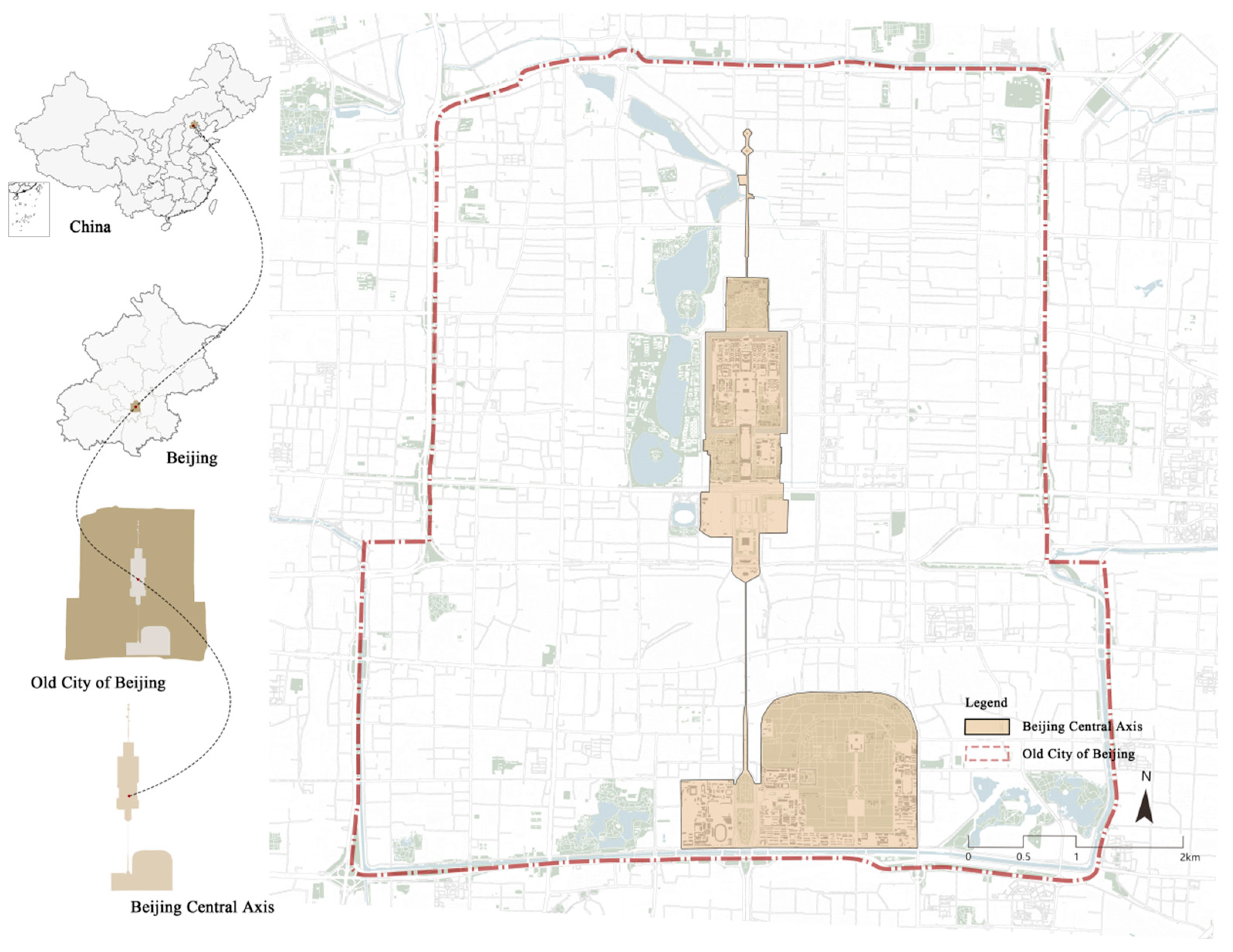
Beijing has a history of over 3000 years as a city and more than 870 years as a capital. Its old city, first established in the Yuan Dynasty (1267 AD) and preserved to this day, serves as a model of ancient capitals [53,54]. The Central Axis, running north–south through the Old City, constitutes the spatial core of the city’s layout (Figure 1). As Mr. Liang Sicheng noted, “The unique and majestic order of Beijing arises from the establishment of this central axis,” a concept reflected in multiple ways: at the planning level, modular proportional relationships shape a rhythmically varied spatial experience; at the architectural level, variations in form, scale, color, and height emphasize hierarchy and order; and at the landscape level, design techniques such as axial and framed views integrate mountains, water, and cityscapes, ultimately creating a grand historical vista system along the Beijing Central Axis [53,54,55,56]. However, with the rapid urban development, the historical vistas along the Central Axis have suffered irreparable damage, such as traditional structures and landscapes have suffered damage, large-scale modern buildings have emerged inside and outside the old city, and the once harmonious traditional skyline has been eroded [55,56]. In response, the new master plan for Beijing, as well as the regulatory plan for the core capital area, proposes to “gradually restore the historical spatial experience” and “construct a vista landscape system to showcase the city’s appearance” [57,58].

3. Methodology

3.1. Selecting Representative Viewing Places and Assessment Points

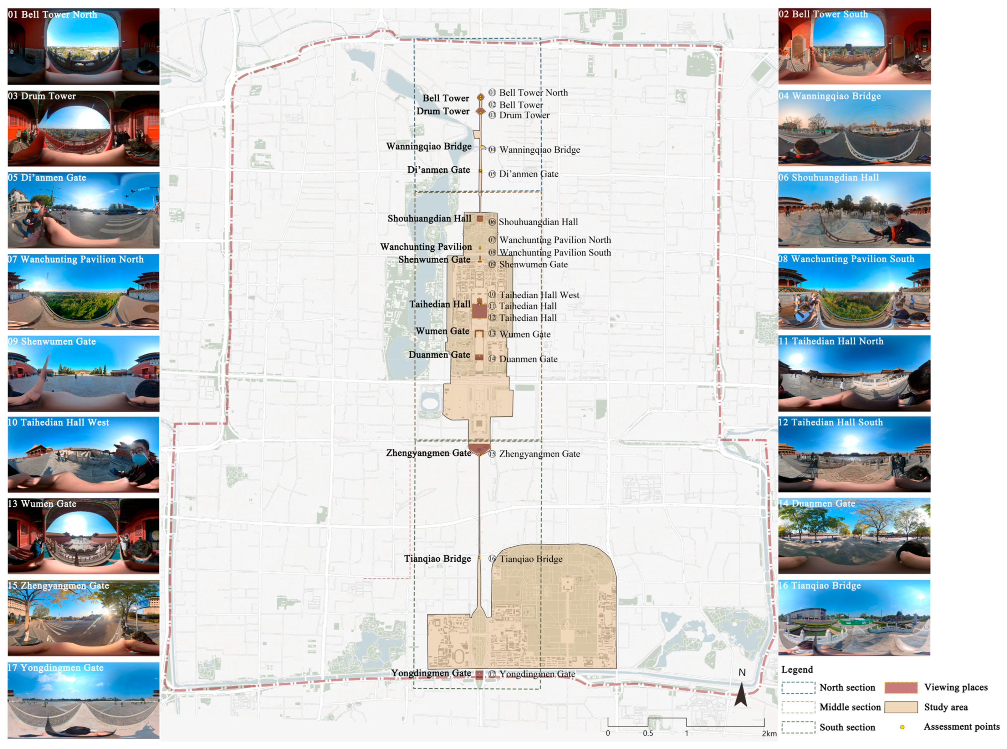
To capture the most representative VR panoramic images of the vistas along the Central Axis, the selection of viewing places and assessment points was of primary importance. A viewing place refers to a public space accessible to the public for viewing [30]. Its selection process integrated policy document review [57,58,59,60,61,62], related literature review [26,55,56], and field surveys. Specifically, the selection referred to strategic landscape landmarks identified in the Regulatory detailed planning of the Capital Functional Core Area (Block Level) (2018–2035) [58] and the Beijing Central Axis Protection and Management Plan (2022–2035) [59]; viewing points defined in the Urban Design Guidelines for Beijing Fifth Facade and Landscape Observation System [60]; protected objects listed in the Beijing Central Axis Cultural Heritage Protection Regulations [61]; and other important buildings and structures reconstructed in studies on the historical landscapes of Beijing’s old city [63]. After screening and refinement, 16 viewing places were identified from north to south, including the Bell Tower, Drum Tower, Wanningqiao Bridge, Di’anmen Gate, Shouhuangdian Hall, Wanchunting Pavilion, Shenwumen Gate, Northwest Corner Tower of the Palace Museum, Taihedian Hall, Donghuamen Gate, Wumen Gate, Duanmen Gate, Tian’anmen Gate, Zhengyangmen Gate, Tianqiao Bridge, Yongdingmen Gate. Then, based on field surveys, only those directly located along the Central Axis were retained to ensure consistent viewing angles and comparability across experimental groups. Consequently, the Northwest Corner Tower of the Palace Museum and Donghuamen Gate were excluded, while Tian’anmen Gate was removed due to management restrictions. Finally, 13 typical viewing places were identified as the research subjects (Figure 2).
An assessment point is defined as a single viewpoint selected by the observer from a particular location within a viewing place [30]. Assessment points are determined after further investigating the internal conditions of each viewing place to identify a representative point capable of capturing a 360-degree panoramic image. In most viewing places, such as Shouhuangdian Hall and Wanchunting Pavilion, only one assessment point is sufficient to capture the overall character of the place and its surroundings; however, in some cases where sightlines are obstructed by buildings or structures, multiple assessment points are required to account for different viewing angles, as in the Bell Tower and Taihedian Hall. As shown in Figure 2, 17 assessment points were selected across 13 typical viewing places. To comparing the diverse landscapes along the Central Axis, the axis was divided into three segments—north, middle, and south—and the 17 assessment points were numbered sequentially from north to south: the northern segment comprises ① Bell Tower North, ② Bell Tower South, ③ Drum Tower (Due to management restrictions, point ③ Drum Tower refers to the southern side of the tower.), ④ Wanningqiao Bridge, and ⑤ Di’anmen Gate (Di’anmen Gate was demolished in 1954; here it refers to Di’anmen Street.); the middle segment comprises ⑥ Shouhuangdian Hall, ⑦ Wanchunting Pavilion North, ⑧ Wanchunting Pavilion South, ⑨ Shenwumen Gate, ⑩ Taihedian Hall West, ⑪ Taihedian Hall East, ⑫ Taihedian Hall South, ⑬ Wumen Gate, and ⑭ Duanmen Gate; the southern segment comprises ⑮ Zhengyangmen Gate, ⑯ Tianqiao Bridge, and ⑰ Yongdingmen Gate.

3.2. Capturing and Importing Panoramic Images

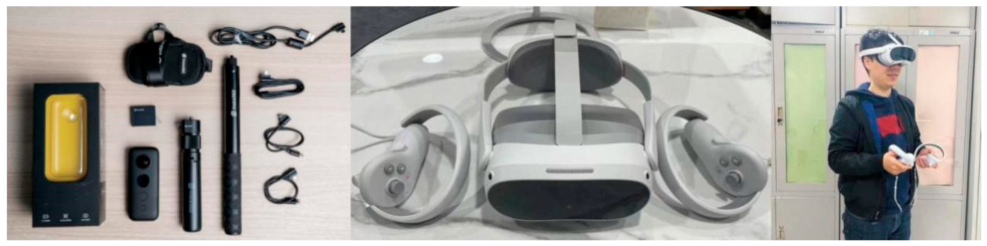
A panoramic camera was used to capture the urban vista landscapes in a 360° viewpoint mode to record the full scene. Shooting was conducted under clear autumn conditions between 10:00 and 14:00, when lighting was relatively stable, at a line-of-sight height of 1.6 m. After multiple field sessions, a total of 175 panoramic images were collected, from which 17 images with clear quality, sufficient lighting, minimal interference, and best representing the actual landscape were selected as experimental samples (Figure 2). The panoramic images were imported into a VR device, saved in JPG format, and copied to a designated folder. Then we used a VR headset and the right-hand controller to confirm the file paths and photo sequence, as well as to check the clarity and interactivity (Figure 3).

3.3. Constructing the Visual Quality Assessment Factor System

Based on classical theories from both natural landscape and built environment evaluation, as well as existing research on vista landscapes, and considering the actual conditions of the vistas along the Central Axis and preliminary observations from VR panoramic images, an evaluation factor system for visual quality was developed. As shown in Table 1, three first-level factors—spatial form, marginal profile, and visual structure—were selected, which were further refined into nine secondary factors and 24 third-level factors.
The theoretical basis for each factor is as follows. First, spatial form, as the fundamental component of urban landscapes, is used to describe the esthetic characteristics of individual buildings and building groups [22,28]. This dimension mainly follows classical architectural esthetic principles. Since artificial elements typically dominate urban vista landscapes, the spatial form of buildings constitutes the core of most evaluation systems [28,29]. It can also be traced back to the “spatial definition” factor in descriptive inventories, which in natural landscapes mainly involves secondary attributes such as size, scale, and surface composition [11]. When introduced into the urban context, it transforms into the depiction of visual relationships involving the scale, texture, and volume of buildings [64,65,66,67,68]. Second, marginal profile, as the primary indicator of the collective urban landscapes, is used to describe the overall dominance and morphological integrity of urban skylines [34,35,36,37]. This dimension can be traced back to the “form” factor in descriptive inventories, which involved secondary attributes such as isolation, size, scale, and contour distinction. In the urban context, its core connotation focuses on the multiple skylines formed at different viewing distances by building groups and natural landscapes—such as urban skylines dominated by high-rise buildings [34,37], by historical landmarks [35,69], or by natural mountain contours [36,37]. In numerous visual assessments of skylines and mountain contours, scholars have mainly focused on the integrity and rhythm of the profiles, as well as the interactions between artificial and natural skyline forms [35,36,37,38]. Third, visual structure is used to describe people’s subjective and holistic perception of the spatial environment and is regarded as a key dimension that integrates spatial form and marginal profile, linking objective visual attributes with subjective cognitive judgments [27,28,35]. This dimension can be traced to the enclosure and hierarchy emphasized in the “spatial definition” factor of descriptive inventories and in architectural esthetics. Existing studies also indicate that visual structure is a dominant dimension in landscape preference evaluation, as the orderliness of visual patches, the clarity of visual organization, and the richness of visual hierarchy all directly shape observers’ visual perception [27,28].
During the process of refining the indicators, considering Beijing’s rich historical background and its traditional approach to human settlement design, the refinement of factors must account for both the built environment—differentiated into traditional and modern building forms—and natural elements such as vegetation and landscape features. Firstly, in terms of spatial form, four secondary factors were selected and further refined into 11 third-level factors: the dimension of scale, which includes the total visual volume of traditional buildings, modern buildings, and plants; the dimension of texture, which includes the texture regularity of traditional buildings, the texture regularity of modern buildings and the texture diversity of plants; the dimension of volume, which includes the volume of a single traditional building and a single modern building; and the dimension of color, which includes the color coordination degree of traditional buildings, the color coordination degree of modern buildings, and the color richness of plants. Secondly, in terms of marginal profile, two secondary factors were selected and further refined into six third-level factors: the dimension of visual integrity, which includes the skyline integrity of traditional buildings, the skyline integrity of modern buildings, and the contour integrity of mountains, and the dimension of visual dominance, which includes the visual dominance of historical landmark buildings, modern architectural monomers, and close-range landscapes. Finally, in terms of visual structure, three secondary factors were selected and further refined into seven third-level factors: the dimension of visual patches, which includes the cohesion and dispersion of traditional buildings and modern buildings; the dimension of visual organization, which includes spatial openness, spatial symmetry, and spatial enclosure; and the dimension of visual hierarchy, which includes the hierarchy sense of buildings and the hierarchy sense of landscapes and plants.
Table 1. Evaluation factor system for the vista landscape of Beijing Central Axis.
First-Order FactorSecondary FactorThird-Level Factor
Spatial formScaleTotal visual volume of traditional buildings [64,65]
Total visual volume of modern buildings [64,65]
Total visual volume of plants [65,66]
TextureTexture regularity of traditional buildings [67]
Texture regularity of modern buildings [67]
Texture diversity of plants [68]
VolumeVolume of a single traditional building [32,33]
Volume of a single modern building [32,33]
ColorColor coordination degree of traditional buildings [27]
Color coordination degree of modern buildings [27]
Color richness of plants [65,66]
Marginal profileVisual integritySkyline integrity of traditional buildings [35]
Skyline integrity of modern buildings [34,35]
Contour integrity of mountains [36,37]
Visual dominanceVisual dominance of historical landmark buildings [35,39]
Visual dominance of modern architectural monomers [34,37]
Visual dominance of close-range landscapes [10,38]
Visual structureVisual patchPatch cohesion and dispersion of the traditional buildings [27]
Patch cohesion and dispersion of the modern buildings [27]
Visual organizationSpatial openness [35]
Spatial symmetry [35,54]
Spatial enclosure [35,54]
Visual hierarchyHierarchy sense of buildings [31,70]
Hierarchy sense of landscapes and plants [28]

3.4. Designing the SBE-SD Scoring Table

Landscape preference is a complex issue characterized by ambiguity and subjective judgment, and precise mathematical methods face inherent limitations in addressing esthetic concepts such as “beauty,” which are difficult to define. To address this, this study introduces Zadeh’s fuzzy logic theory as the underlying framework for designing the scoring table [71,72]. The theory allows an object to partially belong to an esthetic category, such as “very beautiful” or “relatively ordinary,” thereby more realistically simulating the fuzzy cognitive and linguistic judgment processes inherent in human landscape evaluation. In this study, scenic beauty in the SBE method refers to the esthetic quality of the landscape and represents the level of overall visual quality [4,5]. It is classified into seven levels: “very poor”, “relatively poor”, “poor”, “average”, “good”, “relatively good”, and “very good”. Scores ranged from −3 to 3, with 0 as the baseline; positive scores indicated higher visual quality, whereas negative scores indicated lower visual quality. In the SD method, the evaluation of landscape factors for vista landscapes, structured using pairs of opposite adjectives, was measured on a five-point scale ranging from −2 to 2. Zero represented the central point of the scale, positive adjectives corresponded to positive scores, and negative adjectives corresponded to negative scores. Finally, a scoring table for the scenic beauty and landscape factors of the Beijing Central Axis was established following the coding order of the 17 assessment points, as shown in Table S1.

3.5. Collecting and Processing Data for Visual Quality Assessment

Experts and the public tend to judge different landscape types consistently [11,27]; however, experts exhibit more pronounced esthetic preferences for artificial elements in urban landscapes [48]. Professional students can represent experts to evaluate, and studies have shown that using professional students as evaluators achieves high reliability [11,48,73]. In this study, 76 undergraduate and graduate students majoring in urban and rural planning and landscape architecture were recruited. After screening and excluding invalid questionnaires, 60 valid responses were obtained. Initially, participants received basic training in a quiet experimental setting, including instructions on VR headset usage and interactive operation, as well as guidelines for scoring scenic beauty and evaluation factors. During the experiment, participants stood while wearing the headset and observed 17 panoramic images in sequence, with each image viewed freely for up to 45 s. Subsequently, the staff asked questions according to the scoring table and recorded each evaluator’s scenic beauty and landscape factor ratings.
After obtaining the scenic beauty and evaluation factor scores, the scenic beauty scores of each assessment point in the valid questionnaires were standardized, yielding the set Z = {Z1, Z2, …, Z17} of the scenic beauty values of the vista landscapes (i = 1, 2, …, 17). Meanwhile, the landscape factor scores from the valid questionnaires were averaged to produce the landscape factor score matrix X of size 17 × 24, in which each element represents the score of the j-th index of the i-th landscape sample, i ∈ {1, 2, …, 17} and j ∈ {1, 2, …, 24}.

4. Results

4.1. Scenic Beauty Estimation of Vista Landscapes

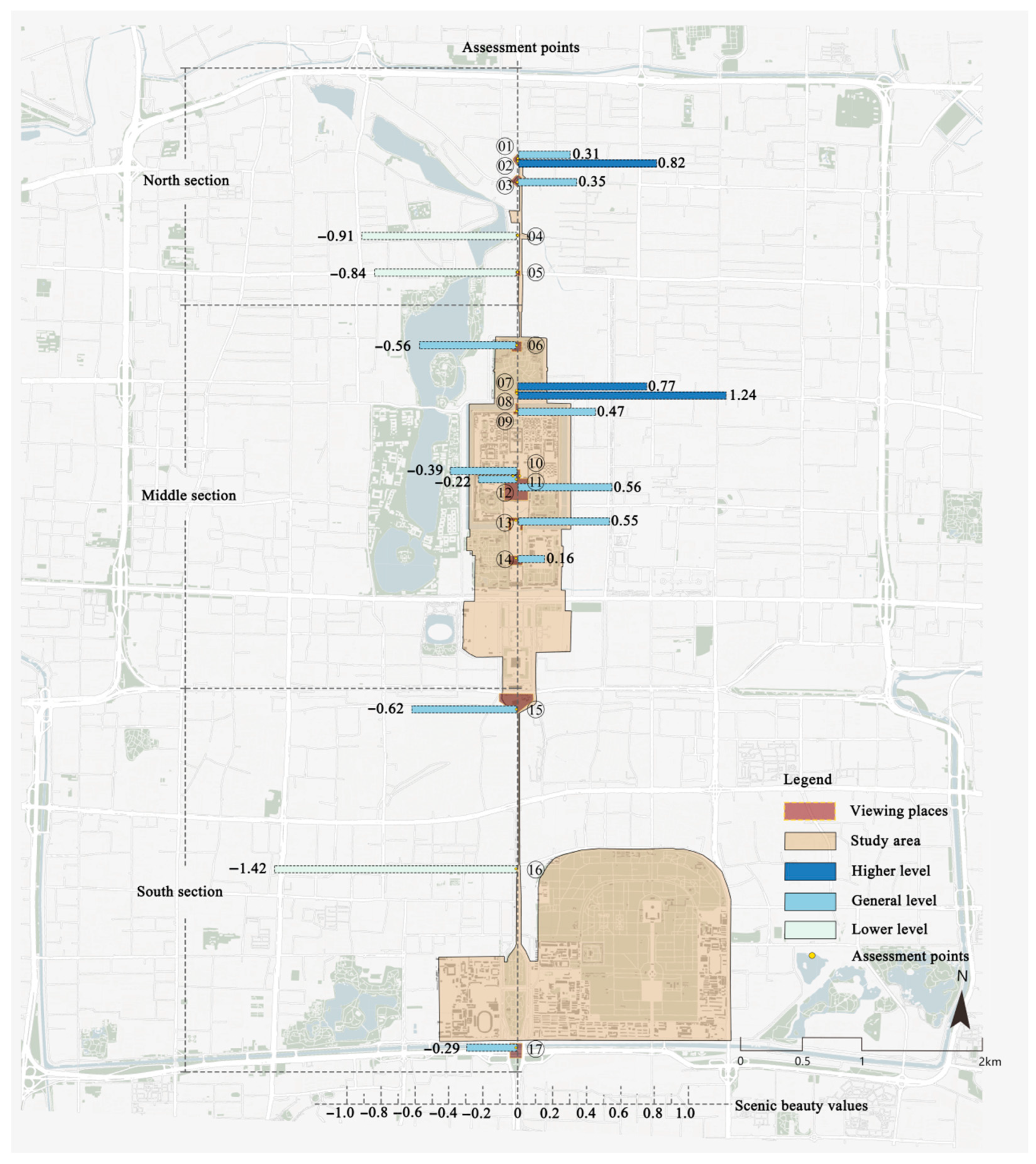
According to Figure 4, the three assessment points with the highest scenic beauty values are point ⑧ Wanchunting Pavilion South (1.24), point ② Bell Tower South (0.82), and point ⑦ Wanchunting Pavilion North (0.77), while the three points with the lowest values are point ⑯ Tianqiao Bridge (−1.42), point ④ Wanningqiao Bridge (−0.91), and point ⑤ Di’anmen Gate (−0.84). The average values for the three sectors are −0.054 for the northern section, 0.287 for the middle section, and −0.776 for the southern section. Overall, the middle section of the Central Axis exhibits the highest scenic beauty, with point ⑧ Wanchunting Pavilion South representing the positive peak. The northern section ranks second, with a relatively high value at point ② Bell Tower South. By contrast, the southern section demonstrates the lowest scenic beauty, reaching a negative peak at point ⑯ Tianqiao Bridge.

4.2. Evaluation of Landscape Factors in Vista Landscapes

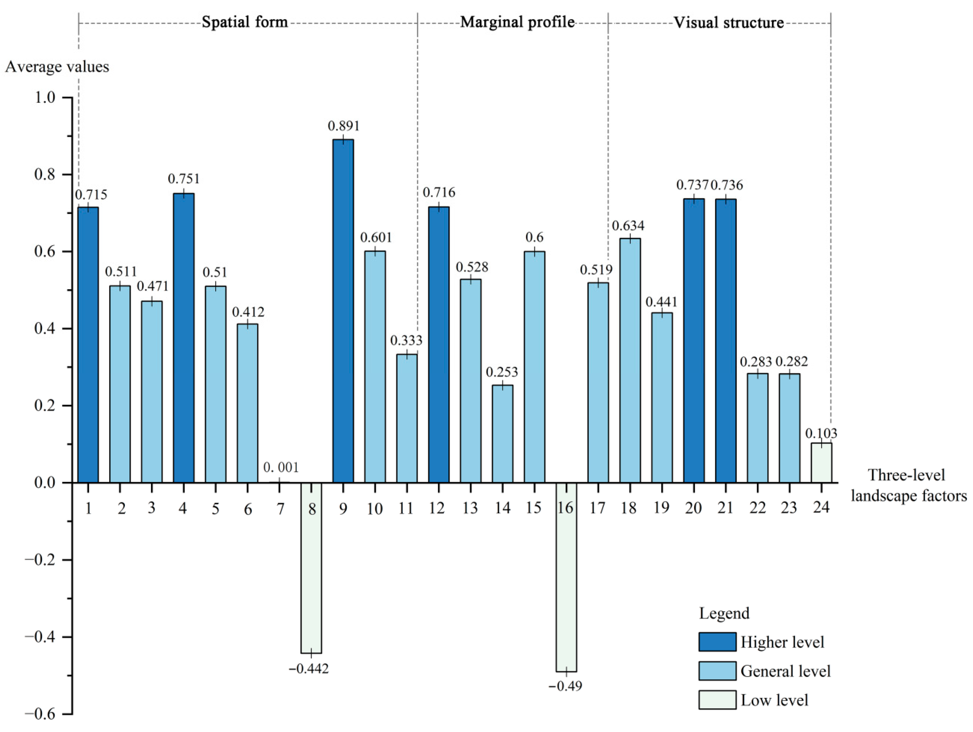
According to Figure 5, six factors received relatively high evaluation scores (≥0.7): color coordination degree of traditional buildings (0.891), texture regularity of traditional buildings (0.751), spatial openness (0.737), spatial symmetry (0.736), skyline integrity of traditional buildings (0.716), and total visual volume of traditional buildings (0.715). By contrast, four factors scored low (≤0.2): hierarchy sense of landscapes and plants (0.103), volume of a single traditional building (0.001), volume of a single modern building (−0.442), and visual dominance of modern architectural monomers (−0.490). In general, in the dimension of spatial form, color-related factors achieved the highest scores, followed by texture and scale, whereas volume-related factors scored the lowest. As for third-level factors, those associated with traditional buildings consistently outperformed the corresponding modern building and plant factors, such as total visual volume and texture regularity. Then, in the dimension of marginal profile, the visual integrity scored higher than the visual dominance. Specifically, traditional building-related factors still outperformed their modern counterparts, with the skyline integrity of traditional buildings being the highest, while the visual dominance of modern architectural monomers was the lowest. Moreover, close-range factors scored higher than long-range factors, with the visual dominance of close-range landscapes reaching 0.519, compared to only 0.253 for the contour integrity of mountains. Finally, in the dimension of visual structure, the visual organization scored the highest, followed by visual patch, while visual hierarchy was relatively low. At the third-level factor level, spatial openness and spatial symmetry were markedly higher than spatial enclosure. By contrast, the hierarchy sense of buildings and the hierarchy sense of landscapes and plants were relatively weak, with values ranging only from 0.1 to 0.3.

4.3. Correlation and Regression Analysis of Scenic Beauty and Landscape Factors in Vista Landscapes

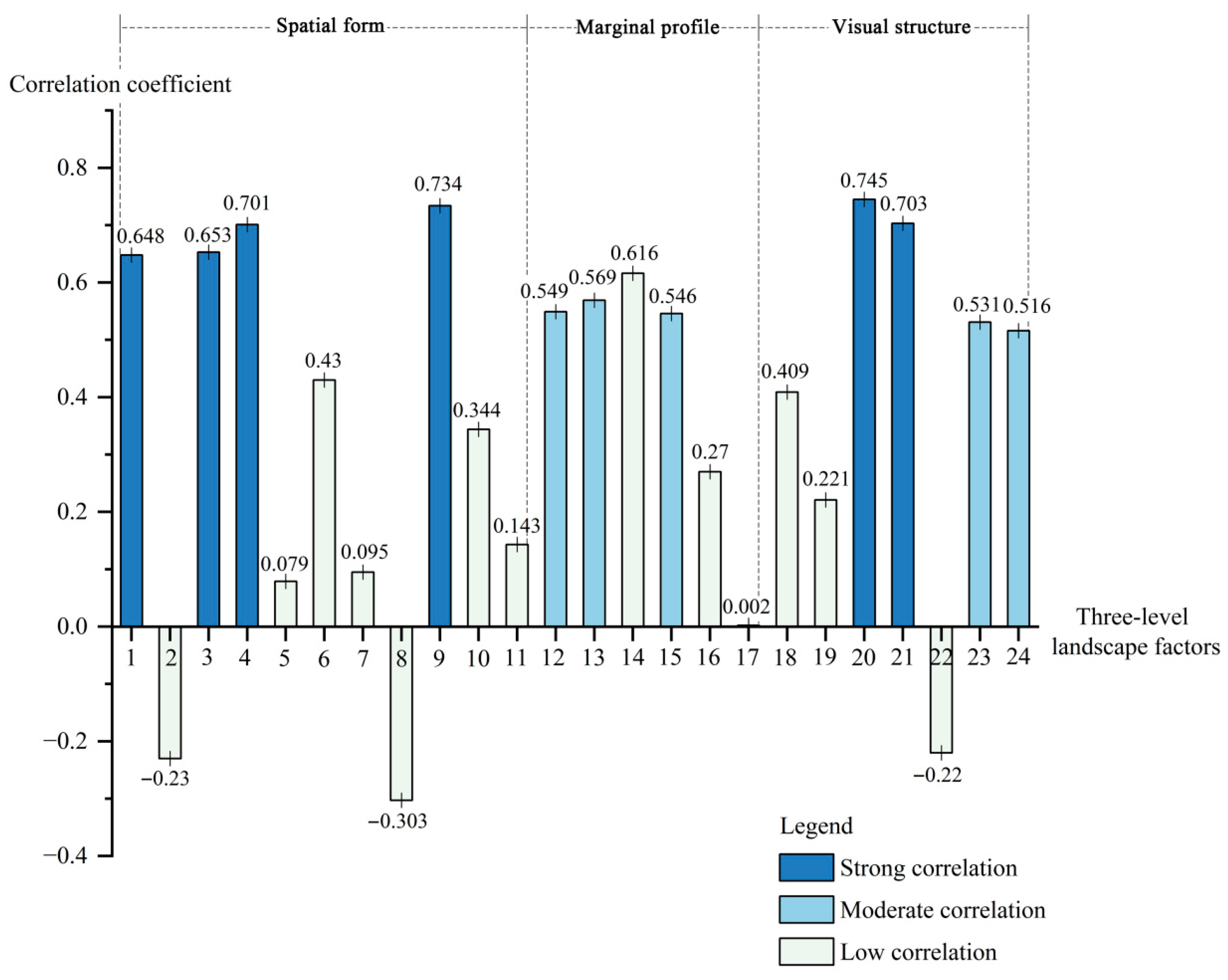
SPSS 25 software was used to analyze the correlation between scenic beauty and landscape factors. When the absolute value of the correlation coefficient exceeded 0.6 and the significance level (Sig.) was below 0.05, scenic beauty and landscape factors were considered strongly correlated; when the coefficient exceeded 0.5 and the Sig. values was below 0.05, they were considered moderately correlated; otherwise, the correlation was weak. According to Figure 6, among the first-order factors, visual structure (4/7) showed the strongest correlation. Its secondary factors, in descending order, were visual hierarchy (2/2), visual organization (2/3), and visual patch (0/2). Marginal profile (3/6) ranked second, with secondary factors in descending order: visual integrity (2/3) and visual dominance (1/3). Spatial form (4/11) had the lowest correlation, with secondary factors in descending order: scale (2/3), color (1/3), texture (1/3), and volume (0/2). At the third-level factor level, six factors showed strong correlations: total visual volume of traditional buildings, total visual volume of plants, texture regularity of traditional buildings, color coordination degree of traditional buildings, spatial openness, and spatial symmetry. Five factors showed moderate correlations: skyline integrity of traditional buildings, skyline integrity of modern buildings, visual dominance of historical landmark buildings, hierarchy sense of buildings, and hierarchy sense of landscapes and plants.
To further analyze the causal relationship between landscape factors and scenic beauty, eleven factors with strong or moderate correlations, as identified through correlation analysis, were included in a regression analysis. A backward stepwise regression analysis was conducted on these eleven factors, sequentially eliminating those with low significance until the Sig. values of all remaining factors were less than 0.05. After ten iterations, two factors were identified as having the greatest influence on scenic beauty: color coordination degree of traditional buildings (Sig. < 0.001) and spatial openness (Sig. < 0.001) (Table 2).
At the same time, the color coordination degree of traditional buildings and spatial openness partially obscured the influence of other factors on scenic beauty. Therefore, the two factors were removed, and the remaining nine factors were subjected to another backward stepwise regression analysis. After eight iterations, two factors were identified: spatial symmetry and hierarchy sense of buildings (Table 3). In other words, when excluding color coordination degree of traditional buildings and spatial openness, spatial symmetry and hierarchy sense of buildings had the greatest impact on scenic beauty, with spatial symmetry (Sig. < 0.001) being more significant than hierarchy sense of buildings (Sig. = 0.008).
After further removing these two factors, the remaining seven factors were subjected to the same analysis. After six iterations, two factors were identified: texture regularity of traditional buildings (Sig. = 0.001) and visual dominance of historical landmark buildings (Sig. = 0.013). At this point, R2 reached 0.677, and the analysis is terminated. If these two were removed again, R2 would fall below 0.6, indicating a lack of statistical significance (Table 4).
In conclusion, after three rounds of backward stepwise regression analysis, six key factors were identified as having the greatest impact on scenic beauty. Ranked by significance, they are color coordination degree of traditional buildings, spatial openness, spatial symmetry, hierarchy sense of buildings, texture regularity of traditional buildings, and visual dominance of historical landmark buildings. Accordingly, visual structure (3/7) exerted the greatest influence on scenic beauty, followed by spatial form (2/11), while marginal profile (1/6) had the least influence.

5. Conclusions and Discussion

5.1. Spatial Differentiation of Scenic Beauty Along the Beijing Central Axis

The scenic beauty along the Beijing Central Axis shows segmental differentiation: the middle section achieves the highest scenic beauty value, followed by the northern section, while the southern section scores the lowest. The score of the middle section is about four times that of the southern section. The assessment points with the highest scenic beauty values are Wanchunting Pavilion South, Bell Tower South, and Wanchunting Pavilion North, while the lowest are Tianqiao Bridge, Wanningqiao Bridge, and Di’anmen Gate.
This divergence is closely linked to the spatial characteristics of the historical built environment in each section, as well as to contemporary preservation and management policies. As a masterpiece of ritual order in ancient Chinese capital planning, the Beijing Central Axis presents differentiated landscapes along its length, shaped by the distinct historical functions and spatial forms of each segment [54,55,63]. The middle section lies largely within the Imperial City, where imperial palaces and altar-temple complexes are arranged in a strict spatial order with a clear axial structure, forming a majestic and highly ordered landscape sequence [62,63]. As the core segment of the Central Axis, it lies within the capital functional core area, where many viewing places are designated as strategic landscape landmarks and several sightlines as strategic view corridors. Under this integrated management framework, the preservation status of the middle section is generally excellent, which explains its high scenic beauty [58,59]. As the area’s dominant topographical high point, Scenery Hill—topped by Wanchunting Pavilion—offers southward views of the grand, well-preserved palace complex and northward views of the Bell and Drum Towers, but weaker visual control in the north makes the southward vista score higher in scenic beauty [26]. By contrast, the southern section of the Central Axis is located in the Outer City, where residential and commercial districts lie to the north and imperial ritual precincts to the south, resulting in a weaker sense of spatial order [62]. Apart from culturally significant areas such as Qianmen, Fayuan Temple, and the Temple of Heaven, much of this section has undergone extensive modernization under relatively relaxed planning regulations, resulting in a generally lower level of scenic beauty [74]. These findings are consistent with Hu et al.’s study on imageability and preference in different areas of Old Beijing, which shows that people tend to favor and remember traditional neighborhoods that are tightly managed and well preserved [75]. Similar patterns have been identified in other historic cities; Agnoletti also found that stronger protection is associated with higher cultural legibility and esthetic coherence [76].
The results clearly reveal the segmental differentiation in the visual quality of vista landscapes along the Beijing Central Axis. Based on these findings, differentiated protection strategies can be developed for different sections of the axis: the middle section, which exhibits relatively high visual quality, should have its vista landscapes further displayed and interpreted; the northern section, with moderate quality, should undergo targeted improvements, particularly around Wanningqiao Bridge and Di’anmen Gate; the southern section, with relatively poor quality, should be comprehensively optimized, especially attention should be placed on preserving the ancient spatial arrangement surrounding Tianqiao bridge.

5.2. Quantitative Analysis of Key Landscape Factors Affecting Scenic Beauty

Based on scenic beauty values and landscape factor scores, and through correlation tests and backward stepwise regression, this study identified the relative influence of landscape factors on scenic beauty. Visual structure received the highest scores and exerted the strongest influence, followed by spatial form, while marginal profile had the weakest effect. At the third-level, six key indicators ranked in descending order of significance: color coordination degree of traditional buildings, spatial openness, spatial symmetry, hierarchy sense of buildings, texture regularity of traditional buildings, and visual dominance of historical landmark buildings.
In historic urban contexts, human visual preferences are closely linked to visual and spatial attributes. Shao et al. demonstrated that stylistic, symbolic, and spatial dimensions significantly enhance visual perception [70], and Yang et al. classified viewpoints using visual hierarchy and esthetic image ratings, but they did not further rank the relative contributions of individual landscape factors to visual quality [22]. In contrast, the study clarifies the structural sources of variation in scenic beauty by identifying the factors that exert the strongest influence on the visual quality of vista landscapes. Moreover, the study reveals a strong positive correlation between scenic beauty and factors associated with traditional buildings, indicating that landscapes with greater historical and cultural value tend to have higher esthetic quality. This aligns with findings by Chen et al. and Coeterier, who showed that rich and enduring historical elements and cultural imagery attract residents and strengthen place identity, fostering a distinct sense of belonging [77,78,79]. Among the specific landscape factors, the color coordination degree of traditional buildings emerges as a key determinant of historic landscape integrity, shaping overall visual quality and influencing silhouette recognition, depth perception, and form cognition [80,81]. While the importance of spatial openness and spatial hierarchy has been widely acknowledged [70,77], spatial symmetry has received far less attention—yet this study’s finding aligns closely with the planning tradition of Old Beijing, which is rooted in ceremonial order and axis symmetry, reflecting the area’s distinctive cultural character [54,55]. Furthermore, the regularity and continuity of the traditional urban fabric reflect the historical logic and everyday rhythms that shaped the city’s development—the more coherent the fabric, the more legible the landscape. Historical landmark buildings, acting as dominant visual nodes, reinforce urban identity, offer clear spatial reference points, and evoke historical associations among residents [70,82].
This study quantifies the relationship between subjective beauty and landscape features, identifies the key factors influencing visual quality, and ranks their relative influence. It is recommended that dedicated studies focus on key landscape factors, such as the color coordination degree of traditional buildings, spatial openness, and spatial symmetry, to develop corresponding evaluation indicators. These indicators can then be integrated into urban design guidelines and protection plan for the Central Axis, supporting the establishment of a citywide vista system that “views the city, mountains and waters, history, and scenery.” This approach provides guidance for the preservation and revitalization of the Central Axis and the Old City of Beijing and could potentially be applied to landscape evaluations in other historic cities or traditional settlement in the future.

5.3. Limitations and Future Perspectives

There are still several limitations and uncertainties in this study. First, the Beijing Central Axis was adopted as a representative case for evaluating the visual quality of vista landscapes, but the study area is relatively small and restricted to a specific type of urban landscape, so the generalizability of the findings remains to be tested in other cities and regions. Future research should therefore include sites with different spatial forms and cultural contexts. Second, vista landscapes are highly sensitive to climatic and lighting conditions, yet this study relied only on images taken under clear autumn weather, which limits its applicability. Future research should incorporate four-season images to enable more robust comparative analyses. Third, panoramic images were captured only from fixed viewpoints within each viewing place, whereas real visual experience is a dynamic process involving continuous movement and intermittent pauses. VR panoramas cannot fully reproduce dynamic behavioral characteristics, such as changing sightlines, shifting visual focus, and perceived rhythm. Future work could therefore define movement routes, produce VR panoramic videos, and combine them with eye-tracking devices, galvanic skin response sensors, and others to obtain multisensory data that more comprehensively captures viewers’ real experience [16,17]. In addition, hardware constraints may cause discrepancies in texture and lighting between VR scenes and real environments, and differences in users’ familiarity with VR may introduce potential perceptual bias [13,42]. Finally, as noted in the introduction, the validity of VR-based evaluation remains under debate, and future studies should systematically compare on-site, photograph-based, and VR-based assessment results to more rigorously test the reliability of landscape visual-quality evaluations [39,40].

5.4. Conclusions

Taking the World Heritage Site of the Beijing Central Axis as the study area, this study develops a quantitative visual assessment scheme for vista landscapes of historic cities by integrating VR panoramic technology with the SBE–SD method. The results show clear sectional differentiation in scenic beauty: assessment points in the middle section score highest, while those in the southern section score lowest. This pattern is jointly driven by multiple landscape factors, whose relative influence ranks as follows: color coordination degree of traditional buildings, spatial openness, spatial symmetry, hierarchy sense of buildings, texture regularity of traditional buildings, and visual dominance of historical landmark buildings. On this basis, zoned and graded optimization strategies can be formulated for different sections and viewing places, and thematic studies on key landscape factors can be carried out to guide the conservation and renewal of historic cities. Moreover, drawing upon classical theories in natural landscapes and built environments, as well as previous research on vista landscapes, this study develops a visual assessment factor system specifically applicable to vista landscapes in historic cities, helping to fill the evaluation system gap in this field. Meanwhile, this study applies VR panoramic technology as both the evaluation material and the technical support and employs the SBE–SD method as the evaluation approach, thereby overcoming the limitations of 2D image-based evaluation and single-method assessment. Overall, this study offers scientific support for the vista conservation, node improvement, and overall visual-character enhancement of the Beijing Central Axis and the Old City of Beijing, while also providing a replicable evaluation scheme that connects subjective perception with the objective environment for similar urban axes and historic cities. Furthermore, this study provides a replicable implementation pathway for promoting the use of VR panoramic technology in landscape assessment. In the future, this technology can be further explored as a novel tool for planning evaluation—for example, by simulating real-world scenes to support quantitative evaluation across various built environments and by modeling alternative planning scenarios to identify more appropriate solutions.

Supplementary Materials

The following supporting information can be downloaded at https://www.mdpi.com/article/10.3390/buildings16020315/s1. Table S1. Scoring table of scenic beauty and landscape factors for vista landscapes along Beijing Central Axis based on the SBE-SD method.

Author Contributions

Conceptualization, X.H. and Y.L.; methodology, X.H., Y.L. and G.Y.; software, X.H. and G.Y.; validation, X.H. and G.Y.; formal analysis, X.H. and G.Y.; investigation, X.H. and G.Y.; resources, X.H. and G.Y.; data curation, X.H. and G.Y.; writing—original draft preparation, X.H., Y.L. and G.Y.; writing—review and editing, X.H., Y.L., M.X. and X.G.; visualization, Y.L., M.X. and X.G.; supervision, Y.L.; project administration, Y.L.; funding acquisition, Y.L. All authors have read and agreed to the published version of the manuscript.

Funding

This work was supported by the National Natural Science Foundation of China under grant number 52078040; the Beijing Social Science Foundation under grant number 18LSC009; the Fundamental Research Funds for the Central Universities under grant number 2021SCZ04; the Beijing Forestry University Professional Degree Graduate Course Case Library Construction Project, grant number KCAL24013; and the Post-funding Project of the National Social Science Fund of China, grant number 25FYSB040.

Institutional Review Board Statement

The study was conducted in accordance with the Declaration of Helsinki, and approved by the Institutional Review Board of the School of Landscape Architecture, Beijing Forestry University (BFU 20241012; 12 October 2024.).

Informed Consent Statement

Informed consent was obtained from all subjects involved in the study.

Data Availability Statement

The original contributions presented in the study are included in the article/Supplementary Materials, further inquiries can be directed to the corresponding author.

Conflicts of Interest

The authors declare no conflicts of interest.

References

  1. Zube, E.H.; Sell, J.L.; Taylor, J.G. Landscape Perception: Research, Application and Theory. Landsc. Plan. 1982, 9, 1–33. [Google Scholar] [CrossRef]
  2. Shafer, E.L., Jr.; Hamilton, J.F., Jr.; Schmidt, E.A. Natural Landscape Preferences: A Predictive Model. J. Leis. Res. 1969, 1, 1–19. [Google Scholar] [CrossRef]
  3. Watts, G.; Marafa, L. Validation of the Tranquillity Rating Prediction Tool (TRAPT): Comparative studies in UK and Hong Kong. Noise Mapp. 2017, 4, 67–74. [Google Scholar] [CrossRef]
  4. Gobster, P.H.; Ribe, R.G.; Palmer, J.F. Themes and Trends in Visual Assessment Research: Introduction to the Landscape and Urban Planning Special Collection on the Visual Assessment of Landscapes. Landsc. Urban Plan. 2019, 191, 103635. [Google Scholar] [CrossRef]
  5. Daniel, T.C. Whither Scenic Beauty? Visual Landscape Quality Assessment in the 21st Century. Landsc. Urban Plan. 2001, 54, 267–281. [Google Scholar] [CrossRef]
  6. Kang, N.; Liu, C. Towards Landscape Visual Quality Evaluation: Methodologies, Technologies, and Recommendations. Ecol. Indic. 2022, 142, 109174. [Google Scholar] [CrossRef]
  7. Yu, C.P.; Lee, H.Y.; Luo, X.Y. The Effect of Virtual Reality Forest and Urban Environments on Physiological and Psychological Responses. Urban For. Urban Green. 2018, 35, 106–114. [Google Scholar] [CrossRef]
  8. Calogiuri, G.; Litleskare, S.; Fagerheim, K.A.; Rydgren, T.L.; Brambilla, E.; Thurston, M. Experiencing Nature Through Immersive Virtual Environments: Environmental Perceptions, Physical Engagement, and Affective Responses During a Simulated Nature Walk. Front. Psychol. 2018, 8, 2321. [Google Scholar] [CrossRef]
  9. Tara, A.; Lawson, G.; Renata, A. Measuring Magnitude of Change by High-Rise Buildings in Visual Amenity Conflicts in Brisbane. Landsc. Urban Plan. 2021, 205, 103930. [Google Scholar] [CrossRef]
  10. Zhang, G.; Cheng, S.; Gao, Y. A Visibility-Based Approach to Manage the Vertical Urban Development and Maintain Visual Sustainability of Urban Mountain Landscapes: A Case of Mufu Mountain in Nanjing, China. Environ. Plan. B Urban Anal. City Sci. 2024, 51, 384–400. [Google Scholar] [CrossRef]
  11. Litton, R.J. Forest Landscape Description and Inventories—A Basis for Land Planning and Design; Us Department of Agriculture, Forest Service, Pacific Forest and Range: Portland, OR, USA, 1968. [Google Scholar]
  12. Sun, Y.; Zhao, X.; Wang, Y.; Li, F.; Li, X. Study on the Visual Evaluation Preference of Rural Landscape Based on VR Panorama. J. Beijing For. Univ. 2016, 38, 104–112. [Google Scholar] [CrossRef]
  13. Swetnam, R.D.; Korenko, J. Can Computer Game Landscapes Target New Audiences for Landscape Quality Assessment? Appl. Geogr. 2019, 113, 102102. [Google Scholar] [CrossRef]
  14. Hull, R.B., IV; Stewart, W.P. Validity of Photo-Based Scenic Beauty Judgments. J. Environ. Psychol. 1992, 12, 101–114. [Google Scholar] [CrossRef]
  15. Lange, E. The Limits of Realism: Perceptions of Virtual Landscapes. Landsc. Urban Plan. 2001, 54, 163–182. [Google Scholar] [CrossRef]
  16. Qin, X.; Fang, M.; Yang, D.; Wangari, V.W. Quantitative Evaluation of Attraction Intensity of Highway Landscape Visual Elements Based on Dynamic Perception. Environ. Impact Assess. Rev. 2023, 100, 107081. [Google Scholar] [CrossRef]
  17. Gao, H.; Abu Bakar, S.; Maulan, S.; Yusof, M.J.M.; Mundher, R.; Chen, B. How Highway Landscape Visual Qualities Are Being Studied: A Systematic Literature Review. Land 2024, 13, 431. [Google Scholar] [CrossRef]
  18. Schüpbach, B.; Kay, S. Validation of a visual landscape quality indicator for agrarian landscapes using public participatory GIS data. Landsc. Urban Plan. 2024, 241, 104906. [Google Scholar] [CrossRef]
  19. Acar, C.; Kurdoglu, B.C.; Kurdoglu, O.; Acar, H. Public preferences for visual quality and management in the Kackar Mountains National Park (Turkey). Int. J. Sustain. Dev. World Ecol. 2006, 13, 499–512. [Google Scholar] [CrossRef]
  20. García, S.P.; Rodríguez, M.M. A Geospatial Indicator for Assessing Urban Panoramic Views. Comput. Environ. Urban Syst. 2015, 49, 42–53. [Google Scholar] [CrossRef]
  21. Czyńska, K.; Rubinowicz, P. Classification of Cityscape Areas According to Landmarks Visibility Analysis. Environ. Impact Assess. Rev. 2019, 76, 47–60. [Google Scholar] [CrossRef]
  22. Yang, J.; Sun, X.; Pan, Y.; Xia, G. Landscape and View: Spatial Analysis and Construction Ways of View System in City. City Plan. Rev. 2020, 12, 103–112. [Google Scholar]
  23. Zhang, T.; Yan, M.; Yu, X.; Liu, B. Visual Assessment of Historic Landmarks Based on GIS and Survey: A Study of View and Viewing of Tiger Hill in Suzhou, China. J. Asian Archit. Build. Eng. 2024, 23, 1079–1093. [Google Scholar] [CrossRef]
  24. Yamada, K. Research on the Spatial Structure of Outer City of Burmese Capital Cities from an Analysis of Mandalay, the Last Royal City of Burma. Urban Reg. Plan. Rev. 2019, 6, 22–44. [Google Scholar] [CrossRef]
  25. Sukwai, J.; Mishima, N.; Srinurak, N. Balancing Cultural Heritage Conservation: Visual Integrity Assessment to Support Change Management in the Buffer Zone of Chiang Mai Historic City Using GIS and Computer-Generated 3D Modeling. Land 2022, 11, 666. [Google Scholar] [CrossRef]
  26. Zhang, J. Pilgrimaging Mountains and Rivers: The Spatial Layout of Ancient Chinese Settlements and Their Environments. Stud. Hist. Gard. Des. Landsc. 2023, 43, 254–278. [Google Scholar] [CrossRef]
  27. Liu, B.; Fan, R. Quantitative Analysis of the Visual Attraction Elements of Landscape Space. J. Nanjing For. Univ. 2014, 38, 149–152. [Google Scholar] [CrossRef]
  28. Lan, W.; Duan, J.; Qi, Z.; Shi, S.; Jiang, Y. Approaches and Methods of City View Planning. Planners 2021, 37, 7. [Google Scholar] [CrossRef]
  29. Wang, J. Four Generations of Urban Design Paradigm from a Rational Planning Perspective. City Plan. Rev. 2018, 42, 9–19, 73. [Google Scholar]
  30. Greater London Authority. London View Management Framework. London. 2012. Available online: https://www.london.gov.uk/programmes-strategies/planning/implementing-london-plan/london-plan-guidance-and-spgs/london-view-management (accessed on 22 November 2025).
  31. Mohseni, F.; Lotfi, S.; Sholeh, M. Proposing an Adapted Visibility Analysis Methodology for the Building Height Codes of the Shiraz Development Plan. Sustain. Cities Soc. 2020, 61, 102347. [Google Scholar] [CrossRef]
  32. Kang, Y. Research on Scenic Beauty Estimation of Urban Skyline in Shenzhen. Ph.D. Thesis, Harbin Institute of Technology, Harbin, China, 2018. [Google Scholar]
  33. Meng, Y. Research on Urban Aerial View Landscape Based on Visual Evaluation-Taking Hefei Government District as an Example. Ph.D. Thesis, Hefei University of Technology, Hefei, China, 2019. [Google Scholar]
  34. Lin, Y.; Ke, Y.; van Den Bosch, C.C.K.; Yu, K.; Zhong, Y.; Liu, J. Bird Eye Analysis of Skyline Views from an Elevated Recreation Trail-The Case of the Fu Forest Trail, Fuzhou, China. Urban For. Urban Green. 2020, 47, 126543. [Google Scholar] [CrossRef]
  35. Karimimoshaver, M.; Parsamanesh, M.; Aram, F.; Mosavi, A. The Impact of the City Skyline on Pleasantness; State of the Art and a Case Study. Heliyon 2021, 7, e07009. [Google Scholar] [CrossRef]
  36. Sukwai, J.; Mishima, N.; Srinurak, N. Identifying Visual Sensitive Areas: An Evaluation of View Corridors to Support Nature-Culture Heritage Conservation in Chiang Mai Historic City. Built Herit. 2022, 6, 23. [Google Scholar] [CrossRef]
  37. Zhang, B.; Zhu, Y.; Zheng, C.; Xu, G. Building Height Control Strategy for Qingyuan Mountain Area in Quanzhou, Fujian in the Relationship of “Mountain-City” Overlooking. Landsc. Archit. 2024, 31, 122–130. [Google Scholar] [CrossRef]
  38. Gu, J.; Wang, X.; Liu, G. Rediscovering the Amenity Value of Urban Landscapes in the Mountainous Areas with High-Rise Buildings from the Perspective of 3D Vertical Urban Systems. Urban For. Urban Green. 2021, 60, 127018. [Google Scholar] [CrossRef]
  39. Xiang, Y.; Liang, H.; Fang, X.; Chen, Y.; Xu, N.; Hu, M.; Chen, Q.J.; Mu, S.; Hedblom, M.; Qiu, L.; et al. The Comparisons of On-Site and Off-Site Applications in Surveys on Perception of and Preference for Urban Green Spaces: Which Approach is more Reliable? Urban For. Urban Green. 2021, 58, 126961. [Google Scholar] [CrossRef]
  40. Gao, T.; Liang, H.; Chen, Y.; Qiu, L. Comparisons of Landscape Preferences through Three Different Perceptual Approaches. Int. J. Environ. Res. Public Health 2019, 16, 4754. [Google Scholar] [CrossRef]
  41. Wróżyński, R.; Pyszny, K.; Sojka, M. Quantitative Landscape Assessment Using LiDAR and Rendered 360 Panoramic Images. Remote Sens. 2020, 12, 386. [Google Scholar] [CrossRef]
  42. Groulx, M.W. Is a Picture Worth a Thousand Words? An Investigation Into the Validity of 3D Computer Landscape Visualizations in Urban Planning. Ph.D. Thesis, University of Waterloo, Waterloo, ON, Canada, 2010. Available online: http://hdl.handle.net/10012/5065 (accessed on 25 October 2025).
  43. Birenboim, A.; Dijst, M.; Ettema, D.; de Kruijf, J.; de Leeuw, G.; Dogterom, N. The Utilization of Immersive Virtual Environments for the Investigation of Environmental Preferences. Landsc. Urban Plan. 2019, 189, 129–138. [Google Scholar] [CrossRef]
  44. Walmsley, A.P.; Kersten, T.P. The Imperial Cathedral in Königslutter (Germany) as an Immersive Experience in Virtual Reality with Integrated 360 Panoramic Photography. Appl. Sci. 2020, 10, 1517. [Google Scholar] [CrossRef]
  45. Edler, D.; Keil, J.; Wiedenlübbert, T.; Sossna, M.; Kühne, O.; Dickmann, F. Immersive VR Experience of Redeveloped Post-Industrial Sites: The Example of “Zeche Holland” in Bochum-Wattenscheid. KN-J. Cartogr. Geogr. Inf. 2019, 69, 267–284. [Google Scholar] [CrossRef]
  46. Shen, H.; Aziz, N.F.; Lv, X. Using 360-Degree Panoramic Technology to Explore the Mechanisms Underlying the Influence of Landscape Features on Visual Landscape Quality in Traditional Villages. Ecol. Inform. 2025, 86, 103036. [Google Scholar] [CrossRef]
  47. Zhou, C.; Zhang, Q.; Sun, Y. Scenic Beauty Estimation of Residential Quarter Green Area. Chin. Landsc. Archit. 2006, 4, 62–67. [Google Scholar] [CrossRef]
  48. Xu, D.; Li, Y. Experts and Public Aesthetic Differences Based on SD-SBE Method. Chin. Landsc. Archit. 2014, 30, 52–56. [Google Scholar]
  49. Yu, K. Landscape Preference: BIB-LCJ Procedure and Comparison of Landscape Preference Among Different Groups. J. Beijing For. Univ. 1988, 10, 1–11. [Google Scholar]
  50. Xu, X.; Dong, R.; Li, Z.; Jiang, Y.; Genovese, P.V. Research on Visual Experience Evaluation of fortress Heritage Landscape by Integrating SBE–SD Method and Eye Movement Analysis. Herit. Sci. 2024, 12, 281. [Google Scholar] [CrossRef]
  51. Fang, Y.; Tian, J.; Namaiti, A.; Zhang, S.; Zeng, J.; Zhu, X. Visual Aesthetic Quality Assessment of the Streetscape from the Perspective of Landscape-Perception Coupling. Environ. Impact Assess. Rev. 2024, 106, 107535. [Google Scholar] [CrossRef]
  52. Shi, J.; Mei, L.; Meng, Y.; Gao, W. Revealing the Relationship Between Urban Park Landscape Features and Visual Aesthetics by Deep Learning-Driven and Spatial Analysis. Buildings 2025, 15, 2487. [Google Scholar] [CrossRef]
  53. Zhang, J. The Cultural Gene of Ancient Chinese; Tsinghua University Press: Beijing, China, 2016. [Google Scholar] [CrossRef]
  54. Lv, Z. The Heritage Value and Beijing Central Axis. J. Beijing Union Univ. (Humanit. Soc. Sci.) 2015, 13, 11–16. [Google Scholar] [CrossRef]
  55. Wang, Y.; Chen, Z. Beijing Vista Landscape Design and Planning. Beijing Plan. Rev. 2017, 175, 29–35. [Google Scholar]
  56. Liu, Y.; Mou, T.; Huang, Z.; Ha, R. Research on Visually Perceived Image and Strategies for Vista View System Improvement of the Jinsitao Waterfront of Shichahai in Beijing. Landsc. Archit. Front. 2019, 7, 121–131. [Google Scholar] [CrossRef]
  57. The People’s Government of Beijing Municipality. Beijing Urban Master Plan (2016–2035). Beijing. 2017. Available online: https://www.beijing.gov.cn/gongkai/guihua/wngh/cqgh/201907/t20190701_100008.html (accessed on 29 September 2017).
  58. The People’s Government of Beijing Municipality. Regulatory Detailed Planning of the Capital Functional Core Area (Block Level) (2018–2035). Beijing. 2020. Available online: https://www.beijing.gov.cn/zhengce/zhengcefagui/202008/t20200828_1992592.html (accessed on 30 August 2020).
  59. The People’s Government of Beijing Municipality. Beijing Central Axis Protection and Management Plan (2022–2035). Beijing. 2022. Available online: https://www.beijing.gov.cn/zhengce/zhengcefagui/202301/t20230130_2908430.html (accessed on 28 January 2023).
  60. Beijing Municipal Commission of Planning and Natural Resources. Urban Design Guidelines for Beijing Fifth Facade and Landscape Observation System. Beijing. 2021. Available online: https://www.gui-hua.com/post/522.html (accessed on 22 November 2025).
  61. The Standing Committee of Beijing Municipal People’s Congress. Beijing Central Axis Cultural Heritage Protection Regulations. Beijing. 2022. Available online: https://wwj.beijing.gov.cn/bjww/362690/362731/flfg33/325852211/index.html (accessed on 25 May 2022).
  62. Beijing Municipal Cultural Heritage Bureau. The Central Axis of Beijing—A Masterpiece of Eastern Ideal Urban Order; Beijing Municipal Cultural Heritage Bureau: Beijing, China, 2021. [Google Scholar]
  63. Liu, Y.; Huang, S.; Ding, X.; Huang, Z. Study on the Historic Image and Current Evaluation of the Vista View Landscape in the Central Axis and Six Seas Area of Beijing. Archit. J. 2021, S2, 6–11. [Google Scholar]
  64. Swietek, A.R.; Zumwald, M. Visual Capital: Evaluating Building-Level Visual Landscape Quality at Scale. Landsc. Urban Plan. 2023, 240, 104880. [Google Scholar] [CrossRef]
  65. Hilal, M.; Joly, D.; Roy, D.; Vuidel, G. Visual Structure of Landscapes Seen from Built Environment. Urban For. Urban Green. 2018, 32, 71–80. [Google Scholar] [CrossRef]
  66. Hammitt, W.E.; Patterson, M.E.; Noe, F.P. Identifying and Predicting Visual Preference of Southern Appalachian Forest Recreation Vistas. Landsc. Urban Plan. 1994, 29, 171–183. [Google Scholar] [CrossRef]
  67. Li, J.; Chu, J.; Wang, Y.; Ma, M.; Yang, X. Reconstruction of Traditional Village Spatial Texture Based on Parametric Analysis. Wirel. Commun. Mob. Comput. 2022, 2022, 5151421. [Google Scholar] [CrossRef]
  68. Malavasi, M.; Conti, L.; Carboni, M.; Cutini, M.; Acosta, A.T. Multifaceted Analysis of Patch-Level Plant Diversity in Response to Landscape Spatial Pattern and History on Mediterranean Dunes. Ecosystems 2016, 19, 850–864. [Google Scholar] [CrossRef]
  69. Zhang, J.; Wang, Y.; Luo, X.; Luan, W.L. Multi-Viewpoint Assessment of Urban Waterfront Skylines: Fractal and Spatial Hierarchy Analysis in Shanghai. Buildings 2025, 15, 1407. [Google Scholar] [CrossRef]
  70. Shao, L.; Ma, P.; Zhou, Z. Research on the Impact of Landscape Planning on Visual and Spatial Perception in Historical District Tourism: A Case Study of Laomendong. Land 2024, 13, 1134. [Google Scholar] [CrossRef]
  71. Zadeh, L.A. The concept of a linguistic variable and its application to approximate reasoning—I. Inf. Sci. 1975, 8, 199–249. [Google Scholar] [CrossRef]
  72. Zadeh, L.A. Outline of a New Approach to the Analysis of Complex Systems and Decision Processes. IEEE Trans. Syst. Man Cybern. 1973, 1, 28–44. [Google Scholar] [CrossRef]
  73. Hull IV, R.B.; Buhyoff, G.J.; Daniel, T.C. Measurement of Scenic Beauty: The Law of Comparative Judgment and Scenic Beauty Estimation Procedures. For. Sci. 1984, 30, 1084–1096. [Google Scholar] [CrossRef]
  74. Sun, Y.; Zheng, C.; Li, M.; Shao, L. A Brief Analysis of Beijing Central Axis and Its Current Conservation State as a Cultural Heritage. World Archit. 2019, 80–87, 139. [Google Scholar] [CrossRef]
  75. Hu, X.; Lin, G.; Zhao, Q.; Wei, T.; Li, Y.; Liu, Y. Urban Image Study Based on Volunteered Geographic Information Platform: A Case of the Old City of Beijing. Urban. Archit. 2025, 22, 1–5. [Google Scholar] [CrossRef]
  76. Agnoletti, M. The Development of a Historical and Cultural Evaluation Approach in Landscape Assessment: The Dynamic of Tuscan Landscape Between 1832 and 2004. In The Conservation of Cultural Landscapes; CABI: Wallingford, UK, 2006; pp. 3–29. [Google Scholar] [CrossRef]
  77. Chen, X.; Cai, J.; Yao, M.; Wang, Y. The relationship between Datong residents’ perception of place meaning and cultural landscape value: Interpretation and mapping. Geogr. Res. 2025, 44, 957–970. [Google Scholar] [CrossRef]
  78. Duan, J.; Lan, W.; Jiang, Y. An Evaluation Approach to Spatial Identity in Historic Urban Areas from a Humanistic Perspective. Front. Archit. Res. 2022, 11, 806–814. [Google Scholar] [CrossRef]
  79. Coeterier, J.F. Lay People’s Evaluation of Historic Sites. Landsc. Urban Plan. 2002, 59, 111–123. [Google Scholar] [CrossRef]
  80. Yang, R.; Deng, X.; Shi, H.; Wang, Z.; He, H.; Xu, J.; Xiao, Y. A Novel Approach for Assessing Color Harmony of Historical Buildings via Street View Image. Front. Archit. Res. 2024, 13, 764–775. [Google Scholar] [CrossRef]
  81. Ratliff, F. Contour and Contrast. Proc. Am. Philos. Soc. 1971, 115, 150–163. [Google Scholar] [CrossRef]
  82. Kang, N.; Liu, C. Assessment of Visual Quality and Social Perception of Cultural Landscapes: Application to Anyi Traditional Villages, China. Herit. Sci. 2024, 12, 235. [Google Scholar] [CrossRef]
Figure 1. Location of Beijing Central Axis.
Buildings 16 00315 g001
Figure 2. 13 typical viewing places and 17 assessment points selected along the Beijing Central Axis.
Buildings 16 00315 g002
Figure 3. VR panoramic image acquisition equipment, observation equipment and wearing mode.
Buildings 16 00315 g003
Figure 4. Scenic beauty values of vista landscapes along the Beijing Central Axis. Note: ① Bell Tower North; ② Bell Tower South; ③ Drum Tower; ④ Wanningqiao Bridge; ⑤ Di’anmen Gate; ⑥ Shouhuangdian Hall; ⑦ Wanchunting Pavilion North; ⑧ Wanchunting Pavilion South; ⑨ Shenwumen Gate; ⑩ Taihedian Hall West; ⑪ Taihedian Hall East; ⑫ Taihedian Hall South; ⑬ Wumen Gate; ⑭ Duanmen Gate; ⑮ Zhengyangmen Gate; ⑯ Tianqiao Bridge, ⑰ Yongdingmen Gate.
Buildings 16 00315 g004
Figure 5. Bar chart of the average values for 24 third-level landscape factors. Note: (1) Total visual volume of traditional buildings; (2) Total visual volume of modern buildings; (3) Total visual volume of plants; (4) Texture regularity of traditional buildings; (5) Texture regularity of modern buildings; (6) Texture diversity of plants; (7) Volume of a single traditional building; (8) Volume of a single modern building; (9) Color coordination degree of traditional buildings; (10) Color coordination degree of modern buildings; (11) Color richness of plants; (12) Skyline integrity of traditional buildings; (13) Skyline integrity of modern buildings; (14) Contour integrity of mountains; (15) Visual dominance of historical landmark buildings; (16) Visual dominance of modern architectural monomers; (17) Visual dominance of close-range landscapes; (18) Patch cohesion and dispersion of the traditional buildings; (19) Patch cohesion and dispersion of the modern buildings; (20) Spatial openness; (21) Spatial symmetry; (22) Spatial enclosure; (23) Hierarchy sense of buildings; (24) Hierarchy sense of landscapes and plants.
Buildings 16 00315 g005
Figure 6. Correlation analysis between the scenic beauty and 24 landscape factors. Note: (1) Total visual volume of traditional buildings; (2) Total visual volume of modern buildings; (3) Total visual volume of plants; (4) Texture regularity of traditional buildings; (5) Texture regularity of modern buildings; (6) Texture diversity of plants; (7) Volume of a single traditional building; (8) Volume of a single modern building; (9) Color coordination degree of traditional buildings; (10) Color coordination degree of modern buildings; (11) Color richness of plants; (12) Skyline integrity of traditional buildings; (13) Skyline integrity of modern buildings; (14) Contour integrity of mountains; (15) Visual dominance of historical landmark buildings; (16) Visual dominance of modern architectural monomers; (17) Visual dominance of close-range landscapes; (18) Patch cohesion and dispersion of the traditional buildings; (19) Patch cohesion and dispersion of the modern buildings; (20) Spatial openness; (21) Spatial symmetry; (22) Spatial enclosure; (23) Hierarchy sense of buildings; (24) Hierarchy sense of landscapes and plants.
Buildings 16 00315 g006
Table 2. Regression analysis of factors influencing the scenic beauty of vista landscapes along Beijing Central Axis.
Regression CoefficientStandardized CoefficientSig.
Constant−1.718 <0.001
Color coordination degree of traditional buildings0.8140.539<0.001
Spatial Openness1.3480.553<0.001
R2 = 0.808
Table 3. Regression analysis of factors influencing scenic beauty after excluding the color coordination degree of traditional buildings and spatial openness.
Regression CoefficientStandardized CoefficientSig.
Constant−1.168 0.000
Spatial symmetry1.3280.6520.001
Hierarchy sense of buildings0.6730.4520.008
R2 = 0.700
Table 4. Regression analysis of factors influencing scenic beauty after further excluding spatial symmetry and hierarchy sense of buildings.
Regression CoefficientStandardized CoefficientSig.
Constant−1.128 0.000
Texture regularity of traditional buildings1.0960.6230.001
Visual dominance of historical landmark buildings0.5080.4400.013
R2 = 0.677
Disclaimer/Publisher’s Note: The statements, opinions and data contained in all publications are solely those of the individual author(s) and contributor(s) and not of MDPI and/or the editor(s). MDPI and/or the editor(s) disclaim responsibility for any injury to people or property resulting from any ideas, methods, instructions or products referred to in the content.