


Abstract
Amid growing global instability and the escalating impacts of climate change, there is an increasing need to develop resilient human habitats, particularly underground environments. At the same time, resource-extraction activities have left behind extensive underground voids in abandoned mines, presenting a valuable opportunity to expand multifunctional spaces that can serve daily needs as well as emergency shelter functions (dual-use), while also supporting urban–rural transformation and sustainable development goals. Due to their geological conditions and mining methods, underground goafs offer inherent advantages for dual-use development. In light of this, this study proposes a theoretical approach to address the three fundamental challenges associated with the dual-use of underground goafs in gypsum mines from the perspective of architectural space creation. This study does not present a completed empirical validation; instead, it develops a conceptual and interdisciplinary methodological framework intended to guide future empirical research and engineering implementation. Specifically, the framework is as follows: (1) defining escape safety capacity under disaster impacts by constructing a dynamic assessment model integrating disaster physics, behavior simulation, and VR-calibrated experiments; (2) elucidating the correlation mechanism between spatial topological features and human response patterns using space syntax and multi-modal psychological experiments to reveal how spatial morphology influences orientation, emotion, and behavior; and (3) moving beyond the traditional notion that space should be adapted to functional requirements, proposing an innovative strategy involving adapting predefined functions to the space.
1. Introduction
1.1. Emerging Demands for Resilient Underground Spaces
The confluence of emergent demands for novel forms of national defense and emergency safety [1], and the imperative for immersive and unique tourism experiences [2], has collectively set higher standards for the resilience and distinctiveness of architectural spaces. Concurrently, nations are also placing significant emphasis on the development of dual-use spaces, designed for both peacetime functionality and emergency shelter [3]. From a different perspective, these requirements transcend traditional architectural boundaries, thereby opening up significant opportunities for the development of underground spaces. Significantly, the immediate utilization of an existing underground space would eliminate the need for extensive excavation, transport, and associated logistical efforts. This approach not only provides a low-carbon solution but also serves as an exemplary model for the adaptive reuse of underutilized space [4].
1.2. “Dual-Use” of Underground Mines
Globally, there are some pioneering attempts at a human-centric utilization of various types of underground mine spaces. For instance, the Wieliczka Salt Mine in Poland, located over 130 m below ground, houses rooms, chapels, salt sculptures, and underground lakes, akin to a subterranean city [5]. In Sweden, the Sala Silver Mine has transformed a section 155 m deep into the “Mine Suite Hotel,” blending its mining heritage with silver-themed furnishings [6]. Romania’s Salina Turda salt mine features an amusement park 120 m underground, offering mini-golf, bowling, and a 180-seat amphitheater [7].
These international precedents illustrate the potential for the transformation of deep, existing underground spaces into urban cultural and tourism facilities and demonstrate the feasibility of developing underground spaces for urban infrastructure functions. However, questions remain regarding whether the substantial long-term investment required for the initial exploration and development of underground spaces can be sustained and replicated in the future. Therefore, for the widespread underground spaces found in gypsum mines, the development goal of “dual-use” for both peacetime and emergency purposes may offer greater sustainability [8]. Dual-use for existing urban underground spaces, established as public infrastructure, provides a broad spectrum of utility, including tourism, health and wellness, leisure, warehousing, and logistics. Moreover, their inherent adaptability becomes critical during emergencies, allowing swift conversion into temporary accommodation for individuals and essential supply transit points. This dual-use capability directly addresses the vital needs for public health intervention (prevention, control, and treatment), emergency shelter, and robust supply chain logistics [9]. This development approach can not only revitalize underground spaces in abandoned urban–rural gypsum mines, but also align with the need for strategic public security and resilience.
1.3. Development Potential of Abandoned Gypsum Mine Goafs in China
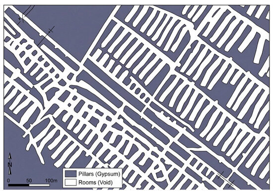
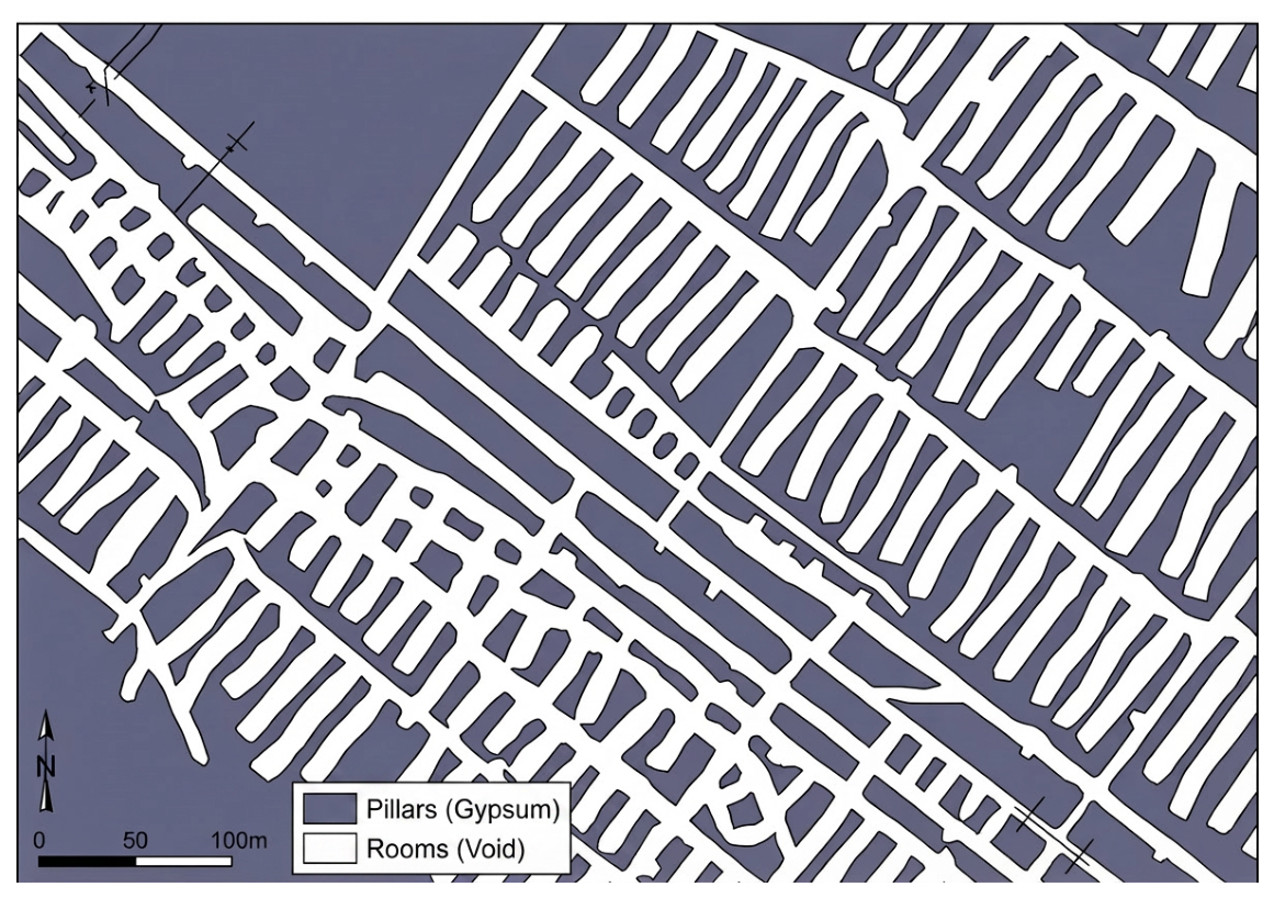
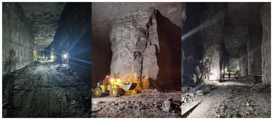
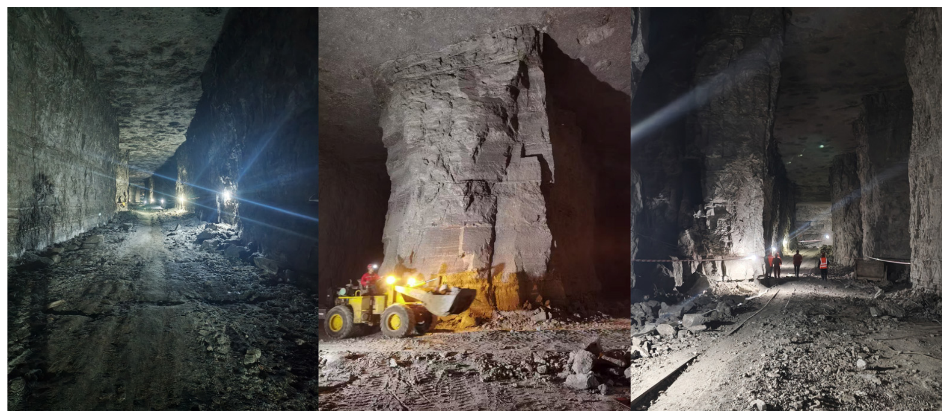
China stands as a global leader in gypsum resources, boasting proven reserves exceeding 80 billion tons and an annual output surpassing 200 million tons, covering rural areas in 23 provinces and municipalities across China [10]. While extensive mining operations have fueled national economic growth, they have also resulted in a considerable number of underground goafs [11]. These abandoned gypsum mine goafs are unique deep artificial underground spaces. Compared to other mineral extraction sites, their redevelopment for human-centric purposes offers distinct advantages [12]. Firstly, the geological conditions are relatively superior (Table 1), with most gypsum mines in China being between 100 and 300 m below ground; however, despite this depth many underground goafs have natural ventilation [13]. The prevalent room-and-pillar mining method also creates relatively intact rock mass integrity due to the support provided by mine pillars. Typically, there is little active groundwater leakage and no accumulation of toxic gases, providing a safer and more stable geological foundation for subsequent human intervention. Secondly, the spatial morphology is rich and diverse (Figure 1). The network of roadways, mine rooms, and pillars created by mining forms a three-dimensional spatial system with varying scales and complex structures, offering morphological possibilities for diverse functional integration. As depicted in Figure 2, the vast and awe-inspiring subterranean spaces of gypsum mines presents significant potential for future cultural and tourism development, and emergency shelters.
Table 1.
Comparative advantages of closed gypsum mine goafs vs. other typical mine goafs for human-centric utilization (by author).
Figure 1.
Plan view of underground gypsum mine layout (by author).
Figure 2.
Underground space of gypsum mine (by author).
1.4. Research Gaps
Despite their considerable redevelopment potential, abandoned gypsum mine goafs remain largely absent from mainstream underground-space research. Existing studies have predominantly concentrated on geotechnical stability, disaster prevention, and resource recovery, while the human occupation and long-term adaptive reuse of these spaces have received limited attention. Consequently, no integrated framework currently exists for evaluating how deep underground goafs can support human activities under both peacetime and emergency-use scenarios. The key challenge lies in current research barriers across relevant disciplines. Specifically, traditional mining engineering research focuses on goaf stability analysis, disaster prevention, and backfilling, primarily aiming to mitigate surface hazards or sequester existing underground spaces for resource recovery [14,15,16]. The existing research focuses on engineering safety and material disposal, lacking in-depth consideration for long-term societal opportunities and activities. Based on research in the field of mining safety, this provides a fundamental guarantee of the stability of spatial structures. In addition, disciplines like architecture and environmental psychology, which focus on human-centric spatial creation, largely base their established theories and mature methodologies on standardized above-ground structures or shallow underground spaces (e.g., subways, underground commercial streets, etc.) [17,18,19]. Architects and designers, therefore, often lack adequate understanding of the unique characteristics of deep, irregular, and non-standard goaf spaces, leading to an incompatibility of existing design tools and evaluation standards when applied to such environments. Consequently, contemporary architectural and spatial design research and practice have seldom explored deep underground goafs, underscoring a critical need for interdisciplinary collaboration [20].
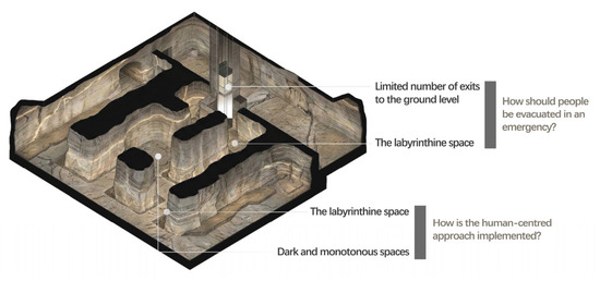
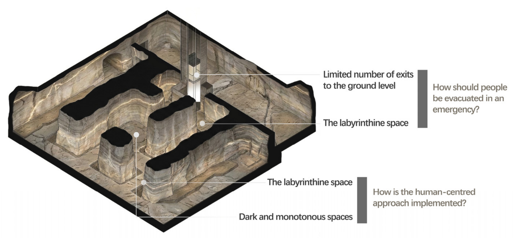
The conventional logic of spatial creation follows the ‘space accommodates demand paradigm’, in which spaces are purposefully designed and shaped to meet human needs [21]. In contrast, the reuse of underground goafs requires a fundamentally different approach: rather than creating new spaces for predefined functions, appropriate functions must be adapted to existing spaces that were not originally intended for human occupation. In response to these development opportunities and real-world challenges, this study presents a preliminary theoretical exploration aimed at understanding how abandoned gypsum mine goafs can be transformed into human-centric underground environments. Specifically, the research focuses on three core dimensions of human-centric spatial design—evacuation safety, psychological comfort, and functional suitability—to investigate the key challenges and corresponding strategies associated with the future utilization of complex underground spatial configurations (Figure 3).
Figure 3.
The challenges posed by closed gypsum mine underground goafs for human utilization (by author).
When developing features for “dual-use” for humans, the key is to put people first [22], whereby, the distinction between “space” and “place” lies in human use [23]. In the following sections, the exploration and synthesis of existing research will focus on urban–rural development, deep-earth safety, and spatial planning, with a view to identifying the ways in which such research supports human- centric underground development and the issues that need to be addressed.
1.4.1. Status of Urban-Rural Underground Space Development
Academician Xie Heping’s proposed “layered development model for underground space” offers a forward-looking guidance [24,25]. China’s urban underground space development has matured in shallow layers (0–50 m), primarily featuring functional infrastructure like rail transit, commercial streets, municipal facilities, and warehousing, and the development of deep underground space (>50 m) that exhibits clear functional divisions. On one hand, scientific frontiers have spurred the rapid growth of deep underground laboratories (e.g., Jinping Underground Laboratory in China, and SNOLAB in Canada) for cutting-edge experiments in particle physics and astrophysics [26,27,28]. On the other hand, driven by energy security considerations, deep-earth energy storage (compressed air energy storage, and pumped storage) has become a research and application hotspot [29,30,31]. However, the use of deep underground spaces for large-scale, long-duration human activities remains relatively scarce, although a few distinctive cases do exist (mentioned in Section 1.2).
Preliminary plans and the potential for developing vertical underground spaces have already been discussed; however, existing research has emphasized energy resources and specialized experimental infrastructure rather than design for people’s daily use.
1.4.2. Status of Safety Assurance for Deep Underground Space Utilization
When creating people-centered spaces in extreme environments, safety is the top priority. Digital twin technology is increasingly applied to mine operation and maintenance, monitoring key parameters in real time with sensors for gas concentration, temperature, and displacement [32], enabling virtual–real interaction and intelligent early warning systems [33,34]. Regarding the structural safety of underground goafs in gypsum mines, studies have already investigated the stability of load-bearing structures based on the characteristics of gypsum pillars. On the issue of groundwater-induced dissolution and instability of mine pillars, Sadeghi Amirshehadi and Vitton’s work has revealed the underlying mechanisms that raise the risk of instability in pillar-support structures [35]. To ensure the long-term load-bearing capacity of pillars, a weathering model was developed, and an exact solution for the time-dependent load-bearing capacity of pillars in abandoned gypsum mines was derived. Parameters were inverted from experimental data to estimate the pillars’ failure time [36]. Building on these findings about the mechanical properties of support structures in underground goafs in gypsum mines, the research provides a basis for future spatial reinforcement measures.
As shown in Figure 1, the complex geometry of underground spaces will pose significant safety challenges to future human-centric use. Methods such as AnyLogic multi-agent simulations are commonly employed to model disaster spread and crowd congestion, enabling the quantification of personnel evacuation performance [37,38]. To identify optimal escape routes in real time during accidents, researchers integrate improved A* algorithms for emergency escape route planning in mines [39]. For various mine disasters (e.g., water inrush, fires), rescue drones are being used to replace inspection robots in evacuation route planning [40].
Regarding spatial construction safety in extreme environments, the gypsum mines’ comparatively favorable environmental conditions (Table 1) offer promising prospects for future development. As discussed above, extensive research on the support structures of gypsum mine pillars has essentially ensured the integrity and stability of the space. However, few studies have examined the carrying capacity of underground spaces from the perspective of public occupancy, evacuation behavior, and emergency sheltering. Furthermore, studies on underground escape largely rely on existing software simulations, which do not account for human-centric factors such as subjective perception, physical exertion, and route selection among diverse groups under environmental influences. Consequently, human factor experiments are required to address the limitations inherent in software simulations.
1.4.3. Status of the Creation of Architectural Spaces
Disciplines that focus on spatial creation, including architecture, urban studies, landscape architecture, and interior design, collectively offer a robust theoretical repertoire for examining how spaces are adapted to human needs. Core ideas focus upon people-centricity, inclusivity, and the governance of daily experiences within urban and rural contexts. The interdisciplinary fields of environmental psychology and ergonomics provide substantial empirical evidence demonstrating that physical environmental attributes—including spatial scale, acoustics, thermal comfort, materiality, and lighting quality—significantly influence psychological states, thereby shaping perceived safety, emotional well-being, motivation, and behavior [41,42]. In particular, access to natural sunlight has been identified as a fundamental human need and a critical contributor to both psychological health and social stability [43], presenting a major challenge for the development of underground living environments. Methodologically, this body of work often employs measurements of physiological arousal, psychometric surveys, behavioral observations, and controlled experiments to establish design guidelines that foster well-being and productive engagement [44,45,46].
Maslow’s Hierarchy of Needs remains a widely applied heuristic for structuring human-centric evaluation frameworks within the built environment [47]. By linking physiological and safety needs to belonging, esteem, and self-actualization, designers and planners can prioritize interventions that create not only functional spaces but also opportunities for social connection, empowerment, and personal growth [48,49]. Contemporary applications often integrate this hierarchy with multi-criteria decision analyses, user-centered audit tools, and post-occupancy evaluations to assess how spaces perform across multiple need levels [50].
Although research on space and human perception has established a comprehensive theoretical framework and corresponding mechanisms, further study is required to determine how the conditions in deep-earth environments align with human environmental-perception needs. These classic theories are largely derived from observations and summaries of aboveground urban and built environments. When applied to windowless, irregular, and complex underground goafs, their fundamental assumptions face significant challenges. For instance, the concept of visual connection to the outside, which helps alleviate anxiety in aboveground buildings, is entirely absent in deep underground spaces, necessitating alternative spatial-intervention strategies. Existing research rarely delves deeply into specialized issues such as mitigating disorientation and claustrophobic anxiety, or balancing human-centric comfort in complex, homogeneous underground goaf spaces.
1.5. Research Objectives and Contributions
This study concentrates on a design and evaluation perspective that prioritizes human safety, spatial cognition, psychological comfort, accessibility, and functional usability, rather than focusing solely on engineering stability or resource recovery.
Accordingly, this study aims to establish a human-centric methodological framework for the adaptive reuse of abandoned gypsum mine goafs. The framework integrates three interconnected dimensions:
(1) Evacuation safety, focusing on occupancy capacity and emergency-response performance;
(2) Psychological comfort, examining the relationships between underground spatial configurations and human cognitive–behavioral responses;
(3) Functional suitability, developing strategies for matching spatial characteristics with potential dual-use functions.
By synthesizing insights from mining engineering, environmental psychology, human factor engineering, and architectural design, this study contributes an interdisciplinary conceptual foundation for the future development of deep underground spaces. Unlike previous studies that primarily focus on engineering stability or resource recovery, this study shifts attention toward human occupation in deep underground environments and proposes a conceptual framework that integrates safety, psychological, and functional dimensions for the adaptive reuse of abandoned gypsum mine goafs.
It should be noted that the purpose of this study is not to provide empirical verification of a specific underground development project. Rather, the study is positioned as a conceptual and methodological exploration that seeks to establish a theoretical foundation for the future human-centric utilization of abandoned gypsum mine goafs. By synthesizing knowledge from mining engineering, environmental psychology, human factor engineering, and architectural design, this research proposes an integrated framework intended to guide future empirical investigations and practical applications.
2. Conceptual Research Design and Methodological Framework
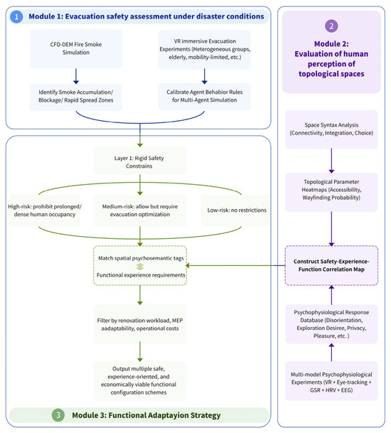
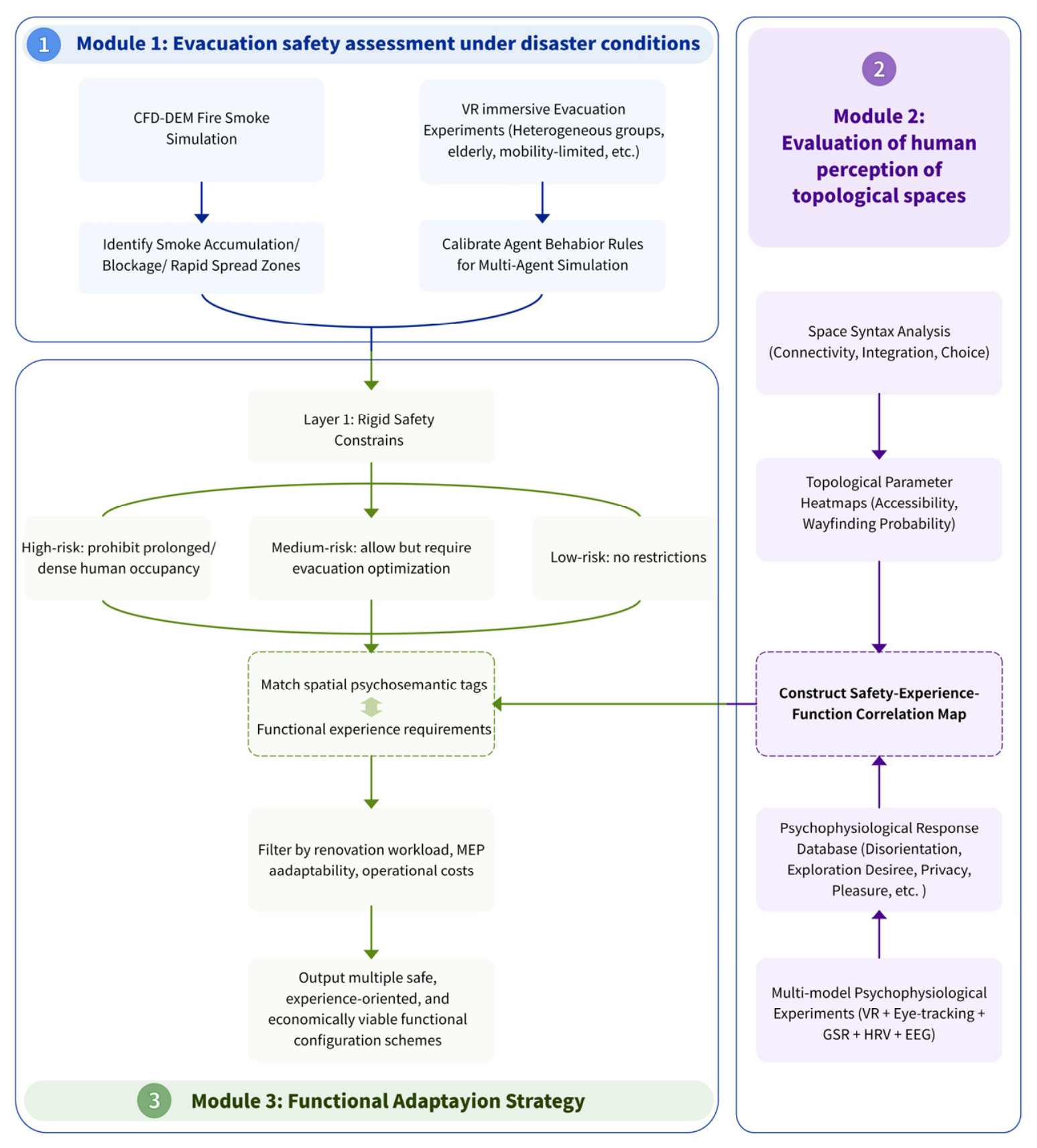
This study adopts a conceptual research design to develop an integrated methodological framework for the human-centric reuse of abandoned gypsum mine goafs. Rather than offering a completed empirical validation, it synthesizes findings from underground safety engineering, environmental psychology, spatial analysis, and adaptive reuse research to establish a three-module framework with objectives that can be tested in future empirical studies (the overall technical roadmap is shown in Figure 4). Presented in a logical progression, these components collectively elucidate the logic of human-centric spatial construction, and form a preliminary exploratory framework for comprehensive, closed-loop development in gypsum mine goafs.
Figure 4.
The technical roadmap (by author).
2.1. Evacuation Safety Assessment Under Disaster Conditions
Although advances in modern engineering can greatly enhance the inherent safety of underground spaces, such as fire-resistant materials, automatic sprinkler systems, and basic safety measures for mechanical and electrical equipment, disaster evacuation remains the ultimate safeguard for their safe use. Given the labyrinthine goafs in gypsum mines, several safety factors—including the unique way complex networks affect the spread of fire and smoke, the limitations of single-shaft configurations for locating escape routes, and the disorientation caused by monotonous surroundings—impose substantial constraints on safety assurance for users. In short, to ensure the safe use of underground goafs in gypsum mines, the following questions should be addressed: How do hazards propagate? How do people locate escape exits? And finally, how should the design facilitate safe evacuation?
Safe evacuation research requires a digital simulation model that can reproduce the complex spatial conditions of underground workings, the physical hazards of disasters (with fire as the primary focus, while also accounting for compound hazards such as ventilation-system failures and the accumulation of smoke and toxic gases), and the evacuation behavior of people under panic, together with the dynamic interactions among these three factors. The core objective is to reveal how disaster propagation pathways, constrained by the specific geometry of underground spaces, impact evacuation efficiency; how crowd behavior evolves under conditions of panic, navigational difficulty, and congestion; and how these factors collectively determine the maximum number of people who can be evacuated safely within a defined time window in a given spatial unit (analogous to the concept of a fire compartment). Ultimately, it is necessary to classify the escape safety potential of each unit of the proposed underground space into graded levels, providing a solid basis for subsequent functional access and capacity control.
2.1.1. The Effect of Geometric Space on the Propagation of Fire Smoke
The integration of computational fluid dynamics (CFD) and the discrete element method (DEM) is required to build numerical models capable of simulating layered movement, thermal accumulation, and diffusion patterns of fire smoke within complex tunnel networks. By exploring simulation scenarios with varying ventilation conditions, fire source locations, and tunnel cross-sectional geometries, the mechanisms by which intricate tunnel geometries impede, guide, or accelerate high-temperature smoke propagation will be elucidated at a mechanistic level. For example, it will be examined whether a labyrinthine tunnel network creates a chimney effect or a blocking effect, and whether narrow side tunnels act as traps for smoke accumulation.
The results should be visualized intuitively through heat maps to explore the relationship between fire smoke dispersion and complex roadway spatial configurations. The objective is to identify smoke accumulation zones, barrier zones that impede smoke movement, and rapid smoke propagation zones within underground goaf spaces. These findings can provide a scientific basis for future dual-use functional adaptation, occupancy management, and targeted spatial retrofit and design strategies.
2.1.2. Underground Evacuation Behavior Patterns Based on VR Experimental Analysis
Underground evacuation differs from ground-level evacuation [51]. Traditional evacuation simulation software largely relies on existing regulations, using pre-set rational agent assumptions or simplified behavioral rules, and thus struggles to reflect real human decision-making biases in environments marked by panic, unfamiliarity, and low light. Consequently, researchers should utilize virtual reality (VR) technology to construct an immersive experimental environment that faithfully replicates the visual characteristics and spatial scale of a gypsum mine goaf area. Evacuation simulations should incorporate heterogeneous user groups—including older adults, individuals with mobility limitations, and participants with different levels of underground-environment experience—by assigning different walking speeds, decision-making behaviors, and stress-response parameters. By collecting real-world decision-making data from these participants within complex, homogeneous, dimly lit tunnels, it will refine and calibrate the behavioral rule set for human agents within multi-agent simulations. This VR experimental calibration phase will ensure that the virtual people in the simulation more closely reflect the demographic characteristics of future real visitors, thereby significantly enhancing the reliability of escape capability predictions.
Research in this area will accurately reflect the impact of complex geometric spaces on evacuation routes. This can guide the adaptation and integration of functional spaces in the future. For example, spaces that are easy to evacuate can be used as main areas for activity or gathering; spaces that are overly complex and difficult to evacuate in evacuation test results may be considered for abandonment in future development, or assigned functions with minimal human use.
2.2. Evaluation of Human Perception of Topological Spaces
The current conditions of underground spaces differ greatly from the above-ground environments with which people are familiar. These spaces were originally designed for mineral extraction, with spatial logic driven by mineral resource conditions and extraction efficiency rather than human spatial perception and behavioral patterns. To create a spatial environment that is physically usable by people, the underground environment must, to some extent, be aligned with the conventions of above-ground architectural spaces.
At present, basic environmental controls—such as lighting, temperature, humidity, and ventilation—can be managed with existing technologies [52]. However, the greatest challenge posed by these confined and geometrically complex spaces lies in the psychological states they induce, including disorientation, depression, and panic [53]. The crux of the issue is to bridge the gap between cold spatial geometric data and warm human experience, establishing a theoretical framework that can explain and predict how the morphology of underground spaces influences individuals’ spatial cognition (sense of direction, distance perception, orientation), emotional responses (claustrophobia, novelty-induced excitement, tranquility and relaxation), and, consequently, collective behavioral patterns.
2.2.1. Identification of Spatial Topological Elements and Psychosomatic Mapping
In response to the ring-shaped, grid-like, and highly homogeneous goaf spaces produced by pillar mining, it is necessary to investigate how people perceive these complex spatial configurations. By incorporating space syntax theory, it is possible to systematically compute topological parameters such as connectivity, integration, and choice [54]. The aim is not merely to list parameters, but to identify key topological indicators that strongly correlate with specific psychological experiences. For example, which parameter combinations effectively predict a person’s sense of disorientation (e.g., low integration, high relative depth, and low loop index)? Which spatial configurations naturally evoke a desire to explore (e.g., moderate integration, and clear sightlines with some obstructions)? In addition, which scale and enclosure levels foster a sense of privacy (e.g., small field-of-view area, few adjacent units, and high enclosure)?
In space syntax, the three core elements that reflect maze-like spatial topological relationships are as follows: connectivity, which is considered whether a location is easy to reach; integration, which represents the probability that the shortest path between any two nodes in the space passes through that node; and choice, which represents the visibility of that node within the surrounding spatial field of view [55]. Using the heatmap generated by overlaying these three layers to reflect its spatial accessibility, the fixed spatial substrate gains interpretable behavioral characteristics, providing directional guidance for subsequent functional adaptation.
2.2.2. Psychological Experiments Using Multimodal Data and the Construction of a Human-Centric Response Database
While topological analysis provides an objective description of spatial forms, people’s actual perceptions of space must be verified and quantified through experimentation. This study will employ a multimodal approach that combines immersive VR environments, eye-tracking, physiological monitoring (skin conductance response, heart rate variability, electroencephalography), post-experimental interviews, and standardized questionnaires. It will systematically investigate how response indicators change under varying spatial scales, aspect ratios, material textures, illuminant color temperatures, and soundscape designs, focusing on metrics such as attention allocation, emotional valence and arousal, spatial memory accuracy, and willingness to pause. The experimental design will encompass typical spatial configurations found in abandoned gypsum mine areas, ranging from spacious mine chambers to large clusters of pillars, and from straight main haulage drifts to dead-end side drifts. By conducting experiments with a large sample of participants, a foundational database of psychological and physiological responses to deep-underground environments will be established.
Future empirical implementation will determine sample size through statistical power analysis. VR environments are intended to be reconstructed from laser-scanned or photogrammetric data of representative gypsum mine goafs to improve ecological validity. Panic and stress responses are proposed to be quantified using physiological indicators such as heart rate variability (HRV), skin conductance response (SCR), and behavioral metrics including hesitation time and route-choice frequency.
2.3. Multi-Objective Functional Adaptation Strategy
This section serves as a bridge and interface between the above two fundamental issues and the final engineering practice. The preceding sections have revealed the intrinsic logic of human-centric utilization of underground goafs from the dual perspectives of rigid constraints and flexible principles. The task of this section is to build on this foundation to establish a decision-making and design theory capable of systematically integrating multiple objectives, including safety load-bearing capacity constraints and human-centric adaptation principles.
Traditional spatial design involves creating space according to demand, which may not be suitable for underground spaces that have already taken on complex forms. Such existing spaces were not originally intended for human use; forced design based on this premise may result in waste or a mismatch between space and function. Therefore, an approach akin to heritage revitalization—matching functions to the existing spaces—is applicable here. This will address how the dual-use function can be adapted to existing underground space sites.
2.3.1. Functional Zones Based on Dynamic Safe Evacuation Capacity
Based on the integrated results of the simulations and experiments in Section 2.1, a systematic analysis is conducted on the relationship between Available Safe Evacuation Time (ASET) and Required Safe Evacuation Time (RSET) for each spatial unit under various disaster scenarios. This analysis identifies the core safety evacuation thresholds, including the maximum safe evacuation time, minimum accessibility standards, and the population’s psychological and physiological tolerance limits (such as tolerances to smoke concentration, visibility, and temperature). Using these insights, a safety-potential assessment model suitable for underground spaces in gypsum mines is constructed. Each spatial unit is classified into three categories: high-risk zones (where escape is extremely difficult, with a high risk of disorientation and congestion—access is restricted to unmanned storage or equipment rooms); medium-risk zones (where escape is relatively difficult, requiring optimized escape routes and restricted occupancy density); and low-risk zones (where escape is unimpeded, directional orientation is clear, and safety is controllable) (the specific proposed risk assessment indicators are shown in Table 2). This qualitative zoning will serve as the fundamental basis for subsequent human-centric functional access and personnel-capacity control.
Table 2.
Proposed risk assessment indicators (by author).
2.3.2. Functional Zones Based on Human Perception of Space Assessment
Given the unique premise of “space first, function second” in underground goafs, this study constructs a multi-objective decision model that treats safety as the baseline, user experience as the guiding principle, and engineering economics as the feasible domain. The model employs a hierarchical constraint framework with the first level comprising rigid safety constraints, which enforce mandatory screening of functional types based on the high-, medium-, and low-risk zones defined earlier: high-risk zones strictly prohibit functions involving prolonged human presence or dense gatherings; medium-risk zones permit such functions but require additional evacuation optimization conditions; low-risk zones have no such restrictions. The second level comprises human-centric experience-guided constraints. Based on a safety–experience–function correlation map, within the pool of candidate spaces permitted by safety criteria, the optimization objective is to achieve a personality match between functions and spaces by assessing the degree of alignment between the psychological and semantic tags of spatial topology (such as a sense of disorientation, curiosity, privacy, and pleasure) and the spatial experience requirements of the target functions. The third level is engineering and economic feasibility constraints, which incorporates practical parameters such as renovation workload assessments, the adaptability of mechanical and electrical equipment, and sustainable operating costs to screen candidate schemes for feasibility. These three layers of constraints build upon one another progressively, ultimately yielding several functional configuration schemes that are safe, feasible, experiential, and economically viable, thereby achieving a shift from spatial determinism to constraint-guided adaptive decision-making.
Within the spatial boundaries permitted by safety, experience labels are precisely aligned with functional requirements. For example, passageways with a high risk of disorientation are unsuitable for visitor routes that require clear wayfinding but can be transformed into maze-themed exhibition spaces or orienteering training grounds, turning spatial limitations into resources for engagement. Side passages that evoke a strong desire for exploration are well-suited for immersive art installations or treasure-hunt stations, leveraging and amplifying the space’s inherent psychological tension. Small chambers with a high sense of privacy are highly compatible with meditation spaces, private reading rooms, and counseling pods, whereas spacious, regularly shaped areas with low arousal and high pleasure naturally lend themselves to social public spaces such as underground exhibition halls and cafés. This map is not a static reference table but a probabilistic recommendation model that iterates continuously as experimental data expands, providing a scientific basis for aligning experience and function in subsequent development strategies.
3. Discussion
The proposed “function adapts to space” logic extends adaptive reuse theory from heritage buildings and structures to deep underground spaces. Unlike conventional adaptive reuse, where existing buildings usually retain human-oriented spatial characteristics, underground goafs were originally created for resource extraction and therefore require a stronger emphasis on safety, wayfinding, and environmental adaptation.
3.1. Framework Implications
The following outputs represent theoretical products of the proposed framework.
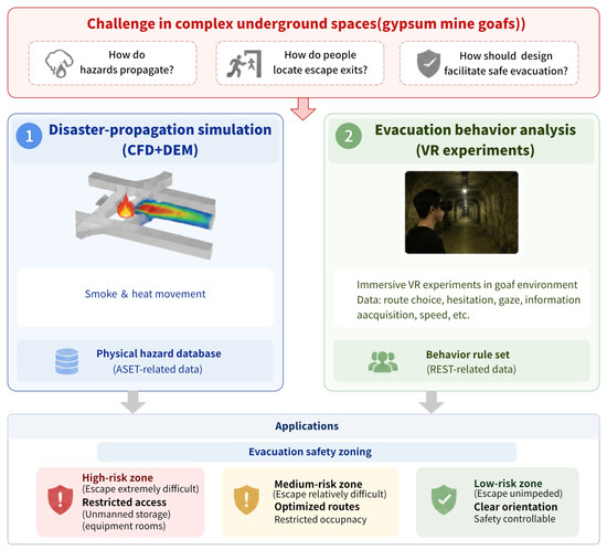
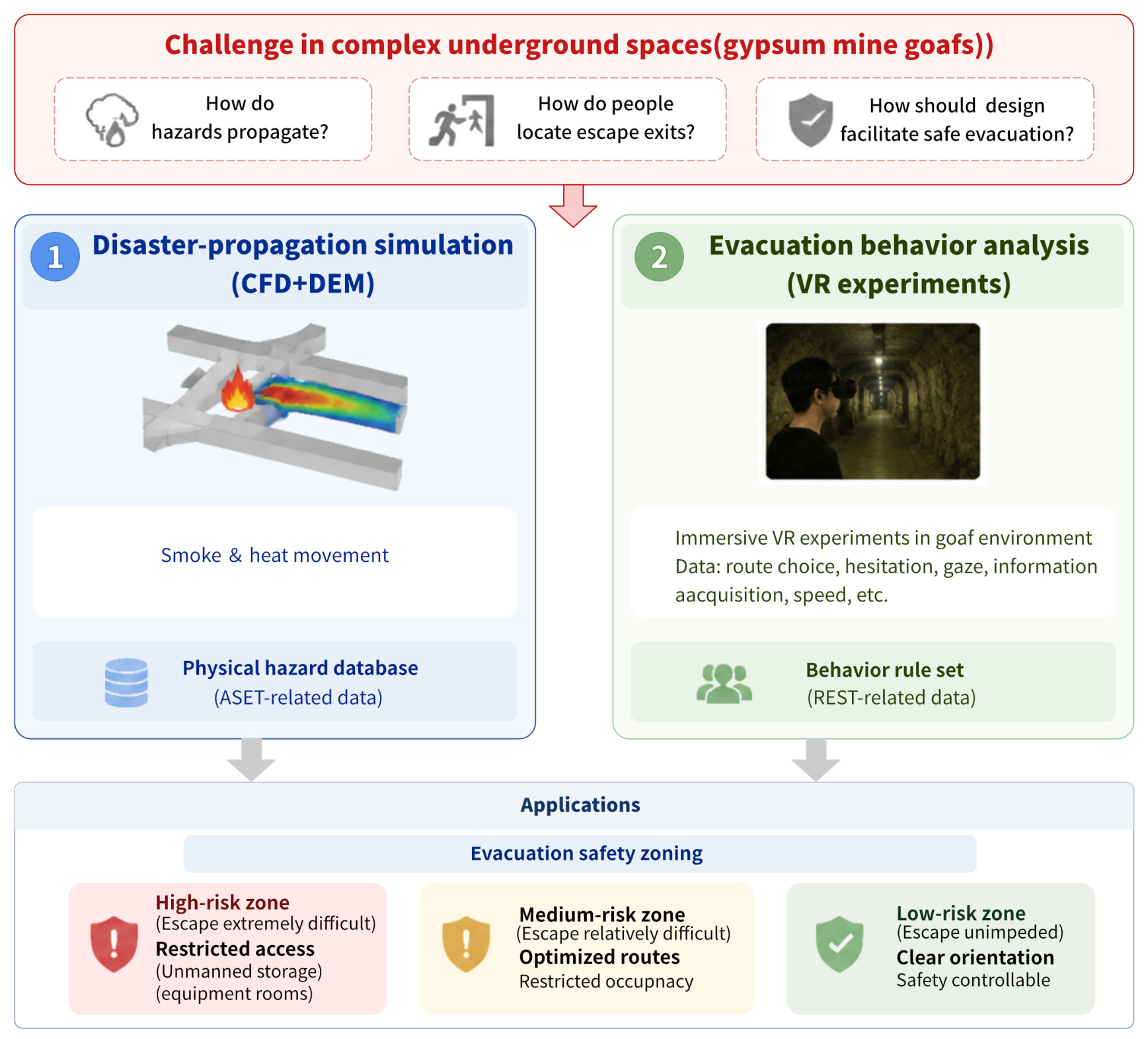
Functional zones based on evacuation safety: A dynamic assessment framework integrating disaster-physics simulations (CFD-DEM), multi-agent crowd modeling, and VR-calibrated human-behavior experiments enables the classification of underground spatial units into high-, medium-, and low-risk zones, thereby establishing a safety baseline for preserving functional accessibility (Figure 5).
Figure 5.
Functional adaptation strategies under evacuation safety constraints (by author).
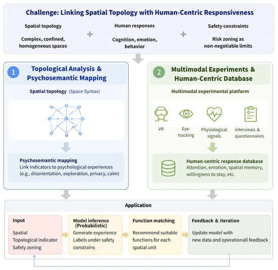
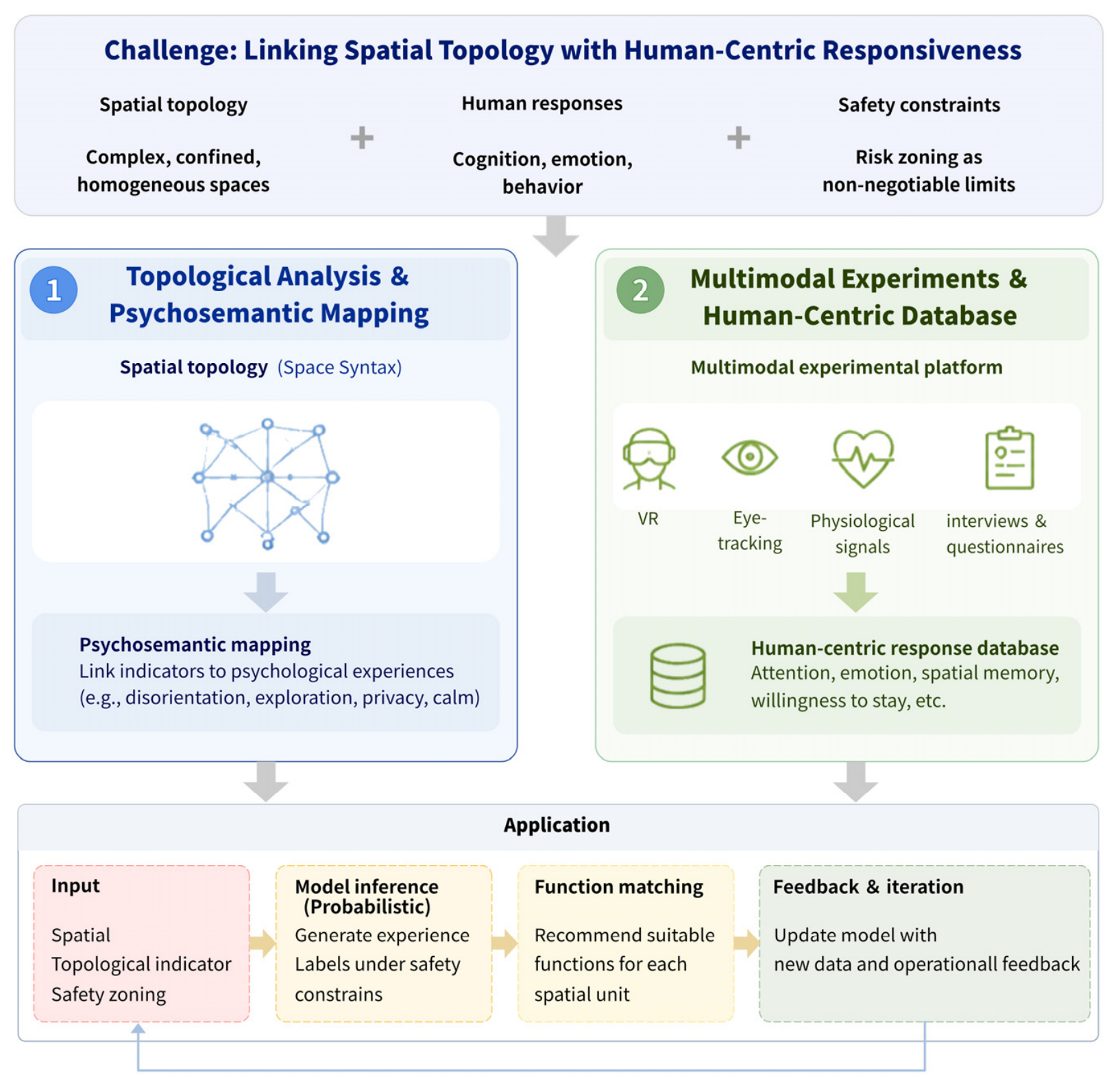
Functional adaptation in the context of spatial topology and human responses: by combining space syntax analysis with multi-modal psychophysiological experiments (eye-tracking, GSR, ECG, and VR-based behavioral recording), a safety–experience–function correlation map was developed. This map reveals how specific topological parameters (integration, connectivity, choice) predict human disorientation, exploration desire, privacy perception, and emotional arousal, thus bridging cold geometric data and warm human experience (Figure 6).
Figure 6.
Psychological comfort based on spatial form (by author).
3.2. Implications for Deep Underground Development
The proposed framework has broader implications for the future development of deep underground spaces beyond the specific context of abandoned gypsum mine goafs. As pressures arising from climate change, urbanization, resource constraints, and emerging security concerns continue to increase, underground spaces are gradually evolving from engineering infrastructures into environments capable of supporting a wider range of human activities. However, current underground development remains largely dominated by engineering-oriented approaches that prioritize structural stability, excavation technologies, and operational efficiency, while paying comparatively limited attention to long-term human occupancy and experience. The framework proposed in this study contributes to addressing this gap by introducing a human-centric perspective into the future development of deep underground spaces.
From a planning and design perspective, the framework highlights the necessity of moving beyond conventional engineering evaluation criteria. Future underground developments should not only satisfy structural and environmental requirements but also support orientation, psychological comfort, accessibility, and meaningful human experiences. The proposed safety–experience–function framework provides a potential decision-support tool for planners and designers when evaluating the suitability of different underground spatial units for specific functions. This approach may facilitate more informed decisions regarding functional allocation, spatial intervention strategies, and occupancy management in complex underground environments.
The framework also has implications for the adaptive reuse of other existing underground resources. Around the world, numerous abandoned mines, tunnels, military facilities, and other subsurface infrastructures remain underutilized despite possessing significant spatial potential. Unlike conventional architectural projects, these spaces already exist and often exhibit highly irregular spatial configurations that cannot be easily reconstructed. Consequently, the proposed “function adapts to space” paradigm represents an important departure from traditional design approaches based on creating new spaces for predefined functions. Instead, it advocates identifying functions that are compatible with existing spatial characteristics, thereby reducing intervention intensity, preserving spatial heritage, and improving resource efficiency.
At a broader strategic level, the framework contributes to ongoing discussions concerning resilient infrastructure and future underground urbanization. Deep underground spaces possess several unique characteristics, including relative environmental stability, protection from extreme weather events, and potential suitability for emergency shelter functions. While the present study does not advocate large-scale permanent underground habitation, it suggests that properly designed underground environments may complement aboveground urban systems by providing spaces for tourism, cultural activities, emergency response, logistics, scientific research, and other specialized functions. Such diversification may enhance the resilience and adaptability of future urban–rural systems under conditions of environmental uncertainty.
The proposed approach reinterprets these spaces as potential spatial assets that can support local revitalization through tourism development, cultural heritage conservation, educational activities, emergency preparedness, and other adaptive reuse initiatives. By providing a structured methodology for evaluating safety, human experience, and functional suitability, the framework offers a potential pathway for transforming abandoned underground spaces from post-mining burdens into valuable components of sustainable regional development.
3.3. Limitations
This article is a theoretical proposal based on an expression-theory approach and represents an innovative preliminary conceptualization of the spatial reuse of deep mines. Its purpose is to provide a reference for the long-term future development of urban–rural systems and the expansion of architectural technologies and applications; however, presently there is still a lack of experimental data from case studies on the reuse of gypsum mines.
Because existing gypsum mines are mainly developed through single-layer underground mining, apart from the main haulage tunnels that may retain vertical spaces of more than ten meters in height, most working faces are about 4 m high. Therefore, the reuse of such underground space is primarily single-layer, and the spatial recognition involved is mainly two-dimensional. However, its limitations still lie in people’s understanding of large-scale three-dimensional space, as well as the three-dimensional evacuation design for future multi-level development of large underground spaces.
4. Conclusions
This study proposes a conceptual interdisciplinary framework for the “dual-use” (peacetime and emergency) transformation of abandoned gypsum mine goafs in China, addressing the current gap between mining engineering practices and human-centric spatial design. Instead of presenting empirical validation, the framework offers a structured methodological approach to guide future research and engineering implementation.
The main theoretical contributions are threefold. First, an evacuation safety assessment module is developed by integrating CFD-DEM disaster physics simulations, multi-agent crowd modeling, and VR-calibrated human behavior experiments. This enables the classification of underground spatial units into high-, medium-, and low-risk zones based on dynamic evaluations of available and required safe evacuation time, thereby establishing a safety baseline for functional accessibility. Second, by combining space syntax analysis with multi-modal psychophysiological measurements (eye-tracking, GSR, HRV, VR-based behavioral recording), the framework elucidates the correlation between spatial topological features (connectivity, integration, choice) and human response patterns, including disorientation, exploration desire, privacy perception, and emotional arousal. A safety–experience–function correlation map is constructed to bridge objective geometric data and subjective human experience. Third, moving beyond the conventional ‘space accommodates demand paradigm’, the study proposes an innovative “function adapts to space” strategy. A hierarchical multi-objective decision model—incorporating rigid safety constraints, human-centric experience guidance, and engineering–economic feasibility—is established to match appropriate functions to existing spatial configurations, turning spatial limitations into design resources.
The framework has obvious and broader implications for deep underground space development beyond gypsum mines and beyond China. It advocates a shift from engineering-oriented approaches to human-centric perspectives, supporting resilient urban–rural transformation, sustainable adaptive reuse of abandoned subsurface resources, and the strategic integration of underground spaces into future settlement systems.
In the future, the feasibility of this methodological framework will be verified using real cases as shown in Figure 1. Based on the results of actual 3D laser scanning of underground mines, computer-based simulation studies will be conducted. At the same time, this will serve as a foundation for future 3D-scale visualizations to enable the full utilization of various spatial typologies.
Author Contributions
Conceptualization, X.Z., Y.L. and T.H.; methodology, X.Z.; formal analysis, X.Z.; investigation, S.G.; resources, X.Z. and Y.L.; data curation, X.Z., Y.L. and S.G.; writing—original draft, X.Z., Y.L. and S.G.; writing—review and editing, X.Z. and S.G.; supervision, Y.L. and T.H.; funding acquisition, X.Z. and S.G. All authors have read and agreed to the published version of the manuscript.
Funding
This research was funded by the National Natural Science Foundation of China Key Program, grant number U23A20598; the Research Development Funding of Xi’an Jiaotong-Liverpool University, grant number RDF-24-01-095.
Data Availability Statement
The authors confirm that the data supporting the findings of this study are available within the article.
Conflicts of Interest
The authors declare no conflicts of interest.
References
- Collier, S.J.; Lakoff, A. The Government of Emergency: Vital Systems, Expertise, and the Politics of Security; Princeton University Press: Princeton, NJ, USA, 2021. [Google Scholar]
- Yawised, K.; Apasrawirote, D. The synergy of immersive experiences in tourism marketing: Unveiling insightful components in the ‘Metaverse’. J. Destin. Mark. Manag. 2025, 37, 101019. [Google Scholar] [CrossRef] [Scilit]
- Xin, F.; Ma, Y.; Liao, P.; Fu, B. Evaluation of the university campus layout for the dual use as a city-level emergency shelter. Habitat Int. 2025, 156, 103285. [Google Scholar] [CrossRef] [Scilit]
- Cui, J.; Broere, W.; Lin, D. Underground space utilisation for urban renewal. Tunn. Undergr. Space Technol. 2021, 108, 103726. [Google Scholar] [CrossRef] [Scilit]
- Bralewska, K.; Rogula-Kozłowska, W.; Mucha, D.; Badyda, A.J.; Kostrzon, M.; Bralewski, A.; Biedugnis, S. Properties of particulate matter in the air of the wieliczka salt mine and related health benefits for tourists. Int. J. Environ. Res. Public Health 2022, 19, 826. [Google Scholar] [CrossRef] [Scilit] [PubMed]
- Pashkevich, A. Processes of reinterpretation of mining heritage: The case of Bergslagen, Sweden. Almatourism-J. Tour. Cult. Territ. Dev. 2017, 8, 107–123. [Google Scholar]
- Avram, S.E.; Rus, L.; Micle, V.; Hola, S.S. Evaluation and Evolution of the Physico-Chemical Parameters of Ocnei and Rotund Lakes Located near the “Salina Turda” Mine, Romania. Water 2022, 14, 2366. [Google Scholar] [CrossRef] [Scilit]
- Skipochka, S.; Serhiienko, V.; Musiienko, S.; Prokhorets, L. Recommendations for the use of underground dual-use structures in Ukrainian realities. Геoтехнічна Механіка 2024, 169, 74–85. [Google Scholar] [CrossRef] [Scilit]
- Wang, W.; Zhu, J.Y.; Wang, G.S.; Guo, X.D.; Jiang, Y.; Lu, D.C. Urban Underground Space Planning Idea and Path Based on a “Dual-Use” Concept. Strateg. Study CAE 2025, 27, 82–94. [Google Scholar] [CrossRef]
- Li, X.; Wang, C.; Huang, K.; Shen, L.; You, C.; Jiang, H.; Zhao, Y. Distribution, origin, industrial application status and prospecting prospect of gypsum in China. Geol. China 2025, 52, 1247–1267. [Google Scholar] [CrossRef]
- Wang, H.; Chen, T.; Xu, G. Characteristics of micro-seismic events induced by ground collapse—A case study in the Rongxing gypsum Mine in Hubei Province, China. Sensors 2024, 24, 1309. [Google Scholar] [PubMed]
- Wu, S.; Wang, H.; Kong, D.; Meng, L.; Zhang, S.; Liu, H.; Li, X.; Wang, M. Exploration and Spatial Utilization of Underground Goaf of Gypsum Mine in Dawenkou Basin. Coal Geol. China 2023, 35, 33–38. [Google Scholar] [CrossRef]
- Reschreiter, H.; Kowarik, K. Bronze Age mining in Hallstatt. A new picture of everyday life in the salt mines and beyond. Archaeol. Austriaca 2019, 103, 99–136. [Google Scholar]
- Wu, G.; Nie, X.; Zhao, L.; Li, Z. Study on the stability of waste rock filling in goaf based on dynamic comprehensive analysis method. Heliyon 2024, 10, e41023. [Google Scholar] [CrossRef] [Scilit] [PubMed]
- Bo, L.; Yang, S.; Liu, Y.; Zhang, Z.; Wang, Y.; Wang, Y. Coal mine solid waste backfill process in China: Current status and challenges. Sustainability 2023, 15, 13489. [Google Scholar] [CrossRef] [Scilit]
- Zhang, Q.; Wang, C.; Han, L.; Hao, J.; Qiao, L.; Chen, S. Study on stability analysis and treatment of underground goaf in metal mine. Min. Metall. Explor. 2023, 40, 1973–1985. [Google Scholar] [CrossRef] [Scilit]
- Najafi, M.; Rahimian, F.; Akanmu, A.A. Human-centric innovation in the built environment. Smart Sustain. Built Environ. 2025, 14, 883–888. [Google Scholar] [CrossRef] [Scilit]
- Zhao, X.; Guo, D.; Chen, Y.; Wu, Y.; Zhu, X.; Du, C.; Chen, Z. Sustainable Comfort Design in Underground Shopping Malls: A User-Centric Analysis of Spatial Features. Sustainability 2025, 17, 2717. [Google Scholar] [CrossRef] [Scilit]
- Yoo, M.; Park, J.; Jeong, J.; Ahn, S. Analysis of influence of seismic impact on evacuability in subway stations. Dev. Built Environ. 2025, 21, 100637. [Google Scholar] [CrossRef] [Scilit]
- Zhang, Y.; Zheng, L.; He, L.; Jiao, Y.; Peng, H.; Gamage, R.P. Bibliometric analysis of research challenges and trends in urban underground space. Deep Undergr. Sci. Eng. 2024, 3, 207–215. [Google Scholar] [CrossRef] [Scilit]
- Goessler, T.; Kaluarachchi, Y. Smart adaptive homes and their potential to improve space efficiency and personalisation. Buildings 2023, 13, 1132. [Google Scholar] [CrossRef] [Scilit]
- Pfeffer, J. The Human Equation: Building Profits by Putting People First; Harvard Business Press: Brighton, MA, USA, 1998. [Google Scholar]
- Tuan, Y.F. Space and Place: The Perspective of Experience; University of Minnesota Press: Minneapolis, MN, USA, 1977. [Google Scholar]
- Xie, H.P.; Zhu, J.; Chen, Y.; Peng, Q.; Zhang, Y. Strategic Conception for Shenzhen Underground Space Development and Utilization; Science Press: Beijing, China, 2020. [Google Scholar]
- Xie, H.; Leung, C.; Wang, J.; Li, X. Advancing deep underground research through integration of engineering and science. Deep Undergr. Sci. Eng. 2022, 1, 1–2. [Google Scholar] [CrossRef] [Scilit]
- Huang, P.; Lv, W.; Huang, R.; Feng, Y.; Luo, Q.; Yin, C.; Yang, Y. Impact of environmental factors on atmospheric radon variations at China Jinping Underground Laboratory. Sci. Rep. 2024, 14, 31402. [Google Scholar] [CrossRef] [Scilit] [PubMed]
- Golovko, V.V.; Kamaev, O.; Sun, J.; Jillings, C.J.; Gorel, P.; Vázquez-Jáuregui, E. Ambient dose and dose rate measurement in SNOLAB underground Laboratory at Sudbury, Ontario, Canada. Sensors 2023, 23, 1945. [Google Scholar] [CrossRef] [Scilit] [PubMed]
- Ren, H.; Wang, Y.; Chen, C.; Fu, G.; Qiu, L.; Guo, L.; Teng, J. Underground laboratories· Deep underground observation· Scientific questions—Insights from observations of multi-physic fields in deep underground labs. Sci. China Earth Sci. 2025, 68, 343–362. [Google Scholar]
- Yuan, Z.W.; Yang, Y.F. Research status and development trends of compressed air energy storage technology. South. Energy Constr. 2024, 11, 146–153. [Google Scholar] [CrossRef]
- Li, T.; Gu, D.Z.; Li, J.F.; Dong, B.; Liu, S. Construction of a pumped-storage peak-shaving system based on abandoned coal mining goafs. Coal Sci. Technol. 2018, 46, 93–98. [Google Scholar] [CrossRef]
- Pu, H.; Bian, Z.F.; Zhang, J.X.; Xu, J.C. Research on a geothermal resource reuse system for abandoned mines. J. China Coal Soc. 2021, 46, 677–687. [Google Scholar] [CrossRef]
- Yuan, L.; Zhang, P.S. Reconstruction and thinking on transparent geological conditions for precise coal mining. J. China Coal Soc. 2020, 45, 11. [Google Scholar] [CrossRef]
- Li, Q.S.; Liu, J.Q.; Li, J.; Zhang, C.; Guo, J.; Wang, X.; Ran, W. Digital twin of mine ecological environment: Connotation, architecture, and key technologies. J. China Coal Soc. 2023, 48, 3859–3873. [Google Scholar] [CrossRef]
- Liu, F.; Wang, H.W.; Liu, Y. Three-dimensional spatial mapping of roadways based on multi-sensor fusion. J. China Coal Soc. 2024, 49, 4019–4026. [Google Scholar] [CrossRef]
- Sadeghiamirshahidi, M.; Vitton, S.J. Laboratory study of gypsum dissolution rates for an abandoned underground mine. Rock Mech. Rock Eng. 2019, 52, 2053–2066. [Google Scholar] [CrossRef] [Scilit]
- Castellanza, R.; Gerolymatou, E.; Nova, R. An attempt to predict the failure time of abandoned mine pillars. Rock Mech. Rock Eng. 2008, 41, 377–401. [Google Scholar]
- Azimi, S.; Delavar, M.R.; Rajabifard, A. Multi-agent simulation of allocating and routing ambulances under condition of street blockage after natural disaster. Int. Arch. Photogramm. Remote Sens. Spat. Inf. Sci. 2017, 42, 325–332. [Google Scholar] [CrossRef] [Scilit]
- Dumitrescu, C.; Radu, V.; Gheorghe, R.; Tăbîrcă, A.I.; Ștefan, M.C.; Manea, L. Crowd panic behavior simulation using multi-agent modeling. Electronics 2024, 13, 3622. [Google Scholar] [CrossRef] [Scilit]
- Duan, W.; Wang, J.G.; Guo, J.J. Mine emergency route design integrating improved A* algorithm and VR technology. Nonferrous Met. Min. 2025, 12, 216–222. [Google Scholar] [CrossRef]
- Sikora, T.; Papić, V. Survey of Path Planning for Aerial Drone Inspection of Multiple Moving Objects. Drones 2024, 8, 705. [Google Scholar] [CrossRef] [Scilit]
- Lee, H.; Lee, E. An Experimental Investigation into the Influence of Colored Lighting on Perceived Spatial Impressions. Buildings 2025, 15, 3511. [Google Scholar] [CrossRef] [Scilit]
- Jaglarz, A. Perception of color in architecture and urban space. Buildings 2023, 13, 2000. [Google Scholar] [CrossRef] [Scilit]
- Ladurie, E.L.R. Histoire du Climat Depuis l’an Mil; Flammarion: Paris, France, 2026. [Google Scholar]
- Reid, T.; Nielson, C.; Wormwood, J.B. Measuring arousal: Promises and pitfalls. Affect. Sci. 2025, 6, 369–379. [Google Scholar] [PubMed]
- Stefana, A.; Damiani, S.; Granziol, U.; Provenzani, U.; Solmi, M.; Youngstrom, E.A.; Fusar-Poli, P. Psychological, psychiatric, and behavioral sciences measurement scales: Best practice guidelines for their development and validation. Front. Psychol. 2025, 15, 1494261. [Google Scholar] [CrossRef] [Scilit] [PubMed]
- Donaldson, S.I.; Cabrera, V.; Gaffaney, J. Following the science to generate well-being: Using the highest-quality experimental evidence to design interventions. Front. Psychol. 2021, 12, 739352. [Google Scholar] [PubMed]
- Tan, K.H.C.; Lee, S.E.; Tham, K.W. Developing a residential well-being framework: A holistic approach integrating the residential environment and Maslow’s hierarchy of needs. Build. Environ. 2025, 285, 113552. [Google Scholar]
- Li, M.; Selim, G.; Birtill, P.; Banahene, L. Designing belonging: A spatial framework for understanding university campus experiences. Archnet-IJAR Int. J. Archit. Res. 2025, 1–23. [Google Scholar] [CrossRef] [Scilit]
- Qin, Z. Multi-space Design of University Libraries from the Perspective of Maslow’s Hierarchy of Needs Theory. J. Eng. 2025, 3, 119. [Google Scholar]
- Ma, Y.; Roosli, R.; Cao, Z.; Zhang, X.; Gai, Y.; Ma, Z. From isolation to integration: A methodological review of adaptive reuse in industrial heritage buildings. Energy Build. 2025, 348, 116474. [Google Scholar] [CrossRef] [Scilit]
- Wei, J.; Deng, Q.; Zhang, L. Study on emergency evacuation in underground urban complexes. PLoS ONE 2022, 17, e0278521. [Google Scholar] [CrossRef] [Scilit] [PubMed]
- Baek, D.; Baek, J.; Noh, J.; Oh, Y.; Lim, L. Toward healthy underground spaces: A review of underground environmental design factors and their impacts on users’ physiological and psychological health. HERD Health Environ. Res. Des. J. 2024, 17, 411–427. [Google Scholar] [CrossRef] [Scilit]
- Li, X.; Chen, Z.; Shu, Y. From underground space planning to implementation: How far will it be? City Plan. Rev. 2020, 44, 39–43+49. [Google Scholar]
- Hillier, B.; Leaman, A.; Stansall, P.; Bedford, M. Space syntax. Environ. Plan. B Plan. Des. 1976, 3, 147–185. [Google Scholar] [CrossRef] [Scilit]
- Jiang, B.; Claramunt, C.; Klarqvist, B. Integration of space syntax into GIS for modelling urban spaces. Int. J. Appl. Earth Obs. Geoinf. 2000, 2, 161–171. [Google Scholar] [CrossRef] [Scilit]

Disclaimer/Publisher’s Note: The statements, opinions and data contained in all publications are solely those of the individual author(s) and contributor(s) and not of MDPI and/or the editor(s). MDPI and/or the editor(s) disclaim responsibility for any injury to people or property resulting from any ideas, methods, instructions or products referred to in the content. |
© 2026 by the authors. Licensee MDPI, Basel, Switzerland. This article is an open access article distributed under the terms and conditions of the Creative Commons Attribution (CC BY) license.