Article

High-Precision Digital Reconstruction and Conservation of Architectural Heritage Based on Virtual Reality


1
Institute of Cultural Resources and Industries, Nanchang University, Nanchang 330031, China
2
Architecture and Design College, Nanchang University, Nanchang 330031, China
3
School of Creative Deign, Wuhan Business University, Wuhan 430056, China
*
Author to whom correspondence should be addressed.
Buildings 2026, 16(10), 1895; https://doi.org/10.3390/buildings16101895
Submission received: 13 April 2026 / Revised: 3 May 2026 / Accepted: 4 May 2026 / Published: 11 May 2026
(This article belongs to the Section Architectural Design, Urban Science, and Real Estate)

Abstract

The conservation and restoration of architectural heritage face dual challenges from natural erosion and human interference, necessitating the adoption of efficient and non-contact digital technologies to achieve sustainable preservation. Virtual reality (VR) technology, with its advantages of immersion, interactivity, and visualization, provides a novel technological pathway for digital documentation, conservation decision-making, and public presentation of architectural heritage. Taking the Fuliang Red Pagoda in Jingdezhen, Jiangxi Province, as the research object, this study constructs a high-precision digital reconstruction and VR interactive application workflow based on the integration of terrestrial laser scanning and close-range photogrammetry. Through point cloud denoising, Iterative Closest Point (ICP) registration, and Poisson surface reconstruction algorithms, a refined three-dimensional model of the pagoda is achieved, and an immersive VR system is developed with functions including component information query, virtual restoration scheme switching, and interactive exploration. The results demonstrate that this technical workflow not only enables non-contact digital archiving of the Fuliang Red Pagoda but also provides a visual decision-support tool for conservation interventions. Under full-scene operation, the system achieves an average rendering frame rate of 92 FPS and maintains motion-to-photon latency below 20 ms, ensuring good real-time performance and interaction stability. The findings indicate that VR-based digital technologies can enhance the scientific rigor of conservation planning and promote public engagement while adhering to the principles of authenticity and minimum intervention. This study provides a replicable technical pathway and practical reference for high-precision digital reconstruction and sustainable conservation of historic buildings.

1. Introduction

Architectural heritage serves as a witness to historical civilization, carrying the memory of human society and the responsibility of cultural transmission. With the rapid development of the economy and the acceleration of urbanization, the conservation of architectural heritage is facing unprecedented challenges, as natural erosion and human-induced damage continuously threaten the integrity and survival of these valuable assets [1]. The importance of architectural heritage conservation and restoration is becoming increasingly prominent, as it not only concerns the inheritance of architectural cultural heritage but also constitutes a key component of the diversity and sustainable development of modern civilization [2].
In the technical implementation of architectural heritage conservation, recent research has demonstrated the effectiveness of combining terrestrial laser scanning (TLS) and photogrammetry, as this integration significantly enhances the precision and completeness of three-dimensional documentation, providing more accurate data for restoration and preservation efforts. For example, Alshawabkeh and Baik explored a fusion-based workflow that integrates imaging and TLS data to produce detailed point clouds suitable for Heritage BIM modeling of the Al Ula heritage site, enhancing both geometric accuracy and visual richness [3]. Earlier work by the same group proposed hybrid scanning strategies to optimize point clouds for reliable parametric reconstruction of heritage buildings [4]. In an archeological context, Davis et al. showed that the joint use of laser scanning, photogrammetry, and 3D photographic reconstruction provides a robust digital record and management tool for rock art documentation, supporting heritage conservation with high-resolution three-dimensional models [5]. While these hybrid workflows improve geometric accuracy and visual richness, most existing studies primarily focus on point cloud reconstruction and visualization, with limited integration into decision-support frameworks. In particular, there remains a gap in leveraging TLS and photogrammetry data for HBIM-enabled VR simulations that allow stakeholders to evaluate intervention and restoration strategies interactively before any physical conservation. In recent years, Historic Building Information Modelling (HBIM) has emerged as a standardized framework for managing and documenting heritage buildings. HBIM integrates geometric, semantic, and non-geometric information into intelligent 3D models, providing a platform for conservation planning, condition monitoring, and maintenance management. Despite its growing adoption, challenges remain in data standardization, interoperability, and semantic enrichment [6]. Despite the growing adoption of HBIM, challenges remain in data standardization, interoperability, and integration with immersive decision-support technologies. This study addresses these gaps by combining HBIM with VR simulations, enabling interactive evaluation of multiple intervention strategies. In doing so, the digital model is transformed from a static recording tool into a dynamic platform that supports both analysis and conservation decision-making.
Against this background, the emergence of virtual reality (VR) technology has brought transformative changes to the field of architectural heritage conservation and restoration. VR technology can simulate a virtual three-dimensional environment through digital devices, enabling users to experience visual, auditory, and even tactile sensations. With its unique immersive experience, high level of interactivity, and strong visualization capability, VR provides innovative solutions for the digital preservation and virtual restoration of architectural heritage, where “virtual restoration” refers to non-physical simulation of conservation interventions, as well as for interactive presentation to the public [7]. Compared with traditional methods, VR technology offers non-invasive data acquisition, accurate three-dimensional reconstruction, immersive experiences, enhanced interactivity and participation, and improved cost-effectiveness in the field of heritage conservation. In particular, it demonstrates significant advantages in reducing physical intervention on heritage entities, providing intuitive educational tools, and promoting public engagement. Through VR technology, precise 3D reconstruction, virtual restoration, and historical scene reproduction can be achieved without physically contacting the heritage object, thereby greatly expanding the scope of architectural heritage conservation and offering the public more intuitive and vivid experiential approaches [8].
Exploring the application of VR technology in architectural heritage conservation and restoration holds significant theoretical and practical value. From a theoretical perspective, this study enriches the theoretical framework of architectural heritage conservation, particularly by providing new perspectives and methodologies for the application of digital preservation technologies [9]. With the continuous development and refinement of VR technology, its application prospects in architectural heritage conservation are increasingly promising [10]. This study also provides references and insights for the broader application of VR technology in the future, promoting the deep integration of heritage conservation with modern technology and facilitating the sustainable preservation and innovative development of cultural heritage [11]. Building on these technological advancements, this research specifically integrates TLS, photogrammetry, HBIM, and immersive VR to create a comprehensive workflow for the Fuliang Red Pagoda. Unlike prior work, the approach not only achieves high-precision digital reconstruction but also enables virtual simulation of conservation interventions, thereby filling the methodological gap in interactive, decision-support-oriented heritage preservation.
This study employs a combination of research methods, including literature review, field investigation, digital modeling, and analytical approaches, to comprehensively and systematically explore and organize the historical background, current condition, and development trends of the architectural culture of the Fuliang Red Pagoda, revealing its unique regional cultural characteristics and folk traditions, and providing important academic support for cultural heritage conservation and inheritance. By integrating technologies such as virtual reality and three-dimensional modeling, the study achieves precise digital reconstruction of the Fuliang Red Pagoda, offering detailed three-dimensional data support for conservation efforts. The research further explores the potential of VR technology in virtual restoration of architectural heritage and evaluates its role in restoration strategy formulation and visualization of restoration outcomes. While realizing the digital preservation and transmission of the architectural culture of the Fuliang Red Pagoda, the study also investigates the application models and development trends of VR in architectural cultural heritage conservation, providing technical support for innovation and advancement in heritage preservation practices. Furthermore, through a VR-based display platform, the study enables digital and interactive presentation and dissemination of the Fuliang Red Pagoda to the public, fostering and enhancing public pride and identity in architectural culture, improving cultural education and tourism experiences, and providing a broad social foundation and public support for architectural heritage conservation and transmission, thereby promoting innovation in the field of digital heritage preservation.

2. Case Selection and Principles of Heritage Conservation

The significance of ancient Chinese pagodas in Chinese history and culture is reflected in multiple aspects, particularly in the dissemination of Buddhism and local cultural traditions. Pagodas also play an important role in local culture, serving not only as symbols of religious belief but also as integral components closely linked to regional history and culture [12]. Beyond their function as religious structures, ancient Chinese pagodas embody profound cultural symbolism. They represent the pursuit of esthetic ideals and serve as important carriers of traditional Chinese culture. Additionally, pagodas have fulfilled various social functions, such as military observation, navigation guidance, landscape embellishment, and scenic enhancement [13]. For example, the Liaodi Pagoda in Ding County, Hebei Province, served a military function, while the Luoxing Pagoda at Mawei Port in Fuzhou, Fujian Province, functioned as an important maritime navigation marker [14].

2.1. Case Study: Fuliang Red Pagoda

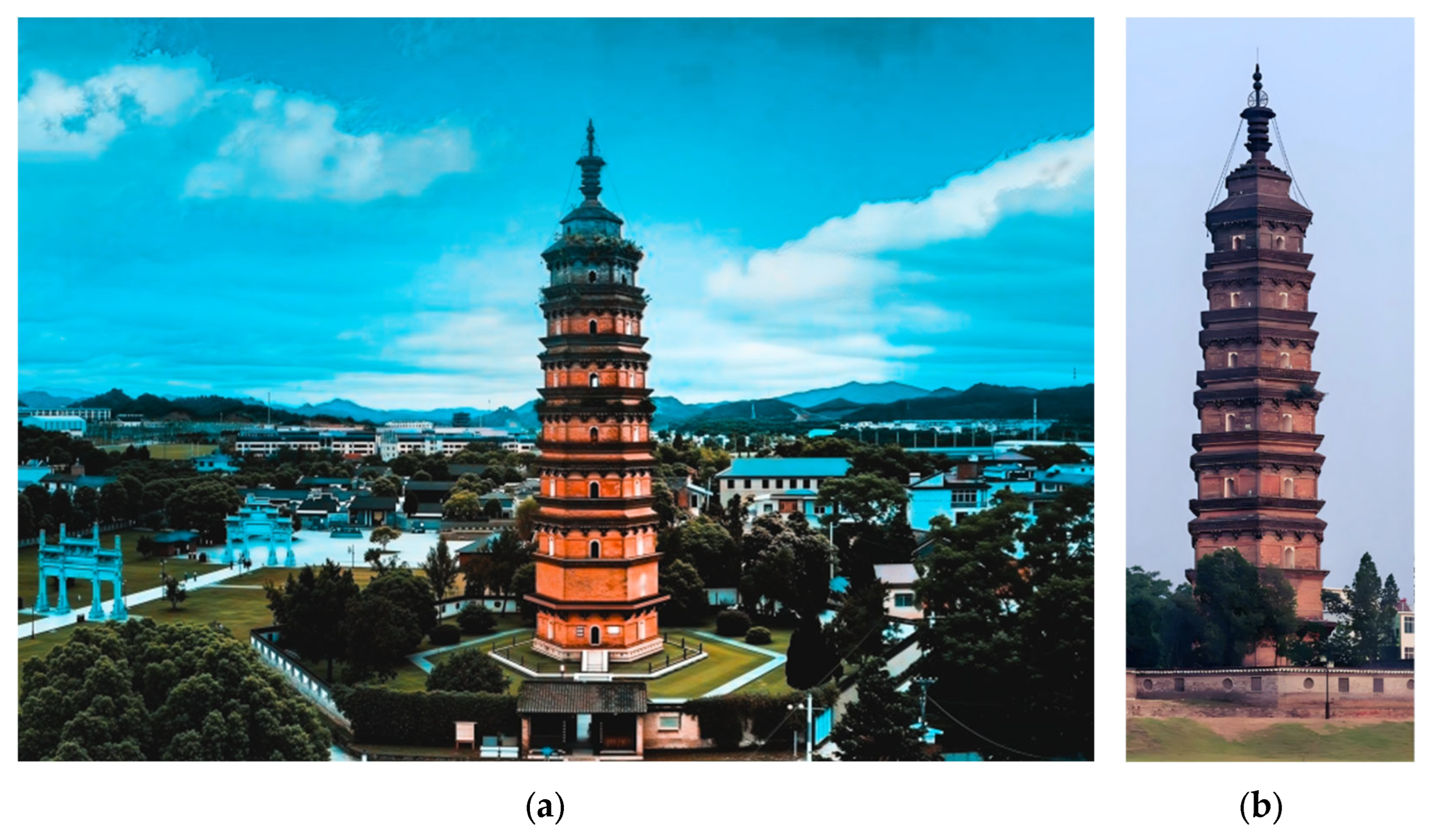
The Fuliang Red Pagoda (Figure 1), originally named the “West Pagoda” and commonly referred to as the “Red Pagoda,” with its Buddhist title “Dasheng Pagoda,” is an ancient pagoda located on a small hill to the west of the old town of Fuliang County, Jingdezhen City, Jiangxi Province, China. It is one of the earliest, largest, and best-preserved ancient pagodas in Jiangxi Province. It is not only one of the seventy-two famous ancient pagodas in China but is also renowned as the “No.1 Pagoda in Jiangxi,” representing a significant architectural heritage site with rich historical and cultural value. The Fuliang Red Pagoda was first constructed in the sixth year of the Taihe period of the Tang Dynasty (832 AD) by the monk Du. During the second year of the Jianlong period of the Song Dynasty (961 AD), local resident Li Wenbiao initiated its reconstruction, which was completed in the first year of the Kangding period (1040 AD). The construction of the pagoda reflects the architectural appearance and artistic style of early Northern Song Buddhist pagodas, representing a fusion of the distinctive characteristics of traditional Chinese pagodas and the architectural features of the Jiangnan region. The pagoda has undergone several restorations throughout history, including a major renovation during the thirteenth year of the Wanli period of the Ming Dynasty (1575 AD). In 1983, the building underwent restoration at the Nanjing Institute of Technology, following professional conservation standards. The name “Red Pagoda” originates from its construction materials: although originally built with blue bricks, the mortar used in brick sealing contained red soil, which gradually leached out over time due to weathering, eventually turning the entire pagoda red [15]. The pagoda originally had nine stories, but due to wars and natural disasters, only seven stories remain today. The Red Pagoda has witnessed the social development and transformation of the Jingdezhen region from the Song Dynasty to the present, serving as an important physical reference for studying ancient Chinese society, economy, culture, and religion [16]. It not only records the evolution of local society but also embodies rich religious, philosophical, and esthetic concepts [17]. Its unique architectural style and exquisite construction techniques demonstrate the wisdom and creativity of ancient craftsmen.
The pagoda body is primarily constructed of large blue bricks, and each level features a cantilevered platform formed through layered masonry, giving the entire structure a simple yet magnificent appearance while reflecting the solidity and stability characteristic of Song Dynasty architecture. The pagoda is approximately 40 m in height, with a base side length of about 20 m. It has a hexagonal plan and is richly decorated. The upturned eaves at each level, along with the relief carvings and painted decorations on the pagoda body, all demonstrate the high level of craftsmanship achieved during the Song Dynasty. The Red Pagoda is not only a key protected cultural relic in Jiangxi Province but also a nationally protected cultural heritage site, serving as valuable physical evidence for the study of ancient Chinese architectural history, Buddhist history, and regional history. Its architectural features embody the superb craftsmanship of Song Dynasty builders and possess significant artistic value [18]. Over time, the Red Pagoda has been subjected to dual threats from natural erosion and human-induced damage. Research on its sustainable conservation and application not only addresses preservation needs but also contributes to a deeper understanding of Song Dynasty construction techniques and cultural context, promotes the inheritance and dissemination of local culture, strengthens cultural identity. VR technology provides new approaches for the conservation and dissemination of the Red Pagoda [19].
The scope of this study mainly focuses on the digital conservation and sustainable utilization of the Fuliang Red Pagoda. Through detailed data acquisition and three-dimensional reconstruction of the structure, an accurate virtual model is established to provide a scientific basis for its sustainable conservation. Meanwhile, VR technology enables the simulation of different conservation and restoration schemes within the virtual model, offering important references for practical sustainable development. Virtual Reality (VR) technology generates immersive and interactive three-dimensional virtual environments through computer systems, with core technical components including 3D reconstruction, real-time rendering, and interactive feedback mechanisms. By using head-mounted displays, handheld controllers, and spatial tracking sensors, users can map their physical movements into the virtual environment in real time, enabling bidirectional interaction between humans and virtual spaces [20]. With the continuous advancement of 5G communication technology, artificial intelligence (AI) algorithms, and cloud computing platforms, VR systems have significantly improved in data processing capacity, graphical rendering quality, and network transmission efficiency. The application model of cross-platform and multi-terminal collaboration has gradually matured, while higher resolutions and lower system latency have further optimized immersive interactive experiences [21]. In the field of architectural heritage conservation, VR technology constructs virtual environments through high-precision digital reconstruction, establishing digital archival systems that can be preserved long-term and repeatedly accessed. This non-contact digital recording method not only provides reliable data support for subsequent academic research and educational dissemination but also offers visual support for conservation decision-making. During the restoration planning stage, researchers can simulate different restoration strategies and material effects within the virtual environment, enabling evaluation and optimization of intervention schemes prior to physical implementation, thereby reducing construction risks.

2.2. Implementation Principles of Architectural Heritage Conservation

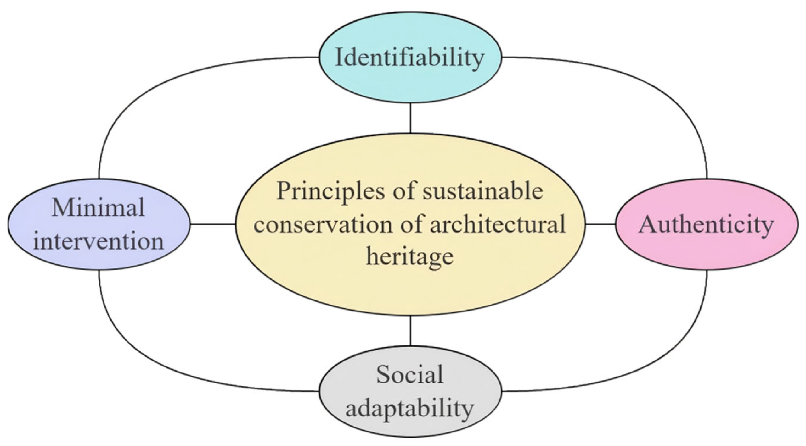
The principles of sustainable conservation of architectural heritage followed in this study are illustrated in Figure 2. The study adheres to the “minimum intervention principle,” meaning that physical contact with the actual structure of the Fuliang Red Pagoda is minimized during data acquisition and assessment to avoid irreversible damage to the historic fabric. Before implementing any conservation measures, their necessity and potential impacts must be systematically evaluated [22]. Through non-destructive techniques such as terrestrial laser scanning, UAV photogrammetry, and close-range photogrammetry, high-precision geometric and surface information of the structure can be obtained, enabling condition assessment and risk identification without direct physical intervention. Early monitoring and prediction can effectively prevent the need for large-scale restoration projects. When restoration is necessary, priority should be given to materials and techniques compatible with the original structure to preserve its historical characteristics and structural integrity to the greatest extent possible [23].
In the process of heritage conservation, the principle of authenticity must be strictly adhered to [24]. Any restoration or reconstruction activities should be based on comprehensive historical documentation and scientific evidence analysis, and, when necessary, incorporate multidisciplinary expert opinions to ensure the accurate transmission of historical information and to avoid misinterpretation or distortion of cultural connotations. At the same time, attention should be given to the adaptive reuse of historic buildings within the contemporary social context. Through appropriate functional renewal and cultural reutilization, architectural heritage can be integrated into community life and public cultural activities, thereby enhancing social participation and public identity, while also activating heritage value and promoting the sustainable development of the regional economy and culture, ultimately achieving a synergistic relationship between heritage conservation and social development [25].

3. Materials and Methods

3.1. Data Acquisition

To ensure the completeness and accuracy of the digital recording of the research object, this study adopts an integrated technical approach combining terrestrial laser scanning and close-range photogrammetry to perform multi-angle and high-precision data acquisition [26]. In addition, to obtain detailed information on the texture and material characteristics of the structure, a three-dimensional laser scanner is employed to conduct comprehensive data acquisition of the Fuliang Red Pagoda, aiming to capture clearer texture information [27]. This type of equipment, characterized by high precision, high speed, and large-scale scanning capability, is well suited for the digital surveying and data acquisition of complex and large-scale individual objects such as historic buildings. Its main technical parameters are shown in Table 1.
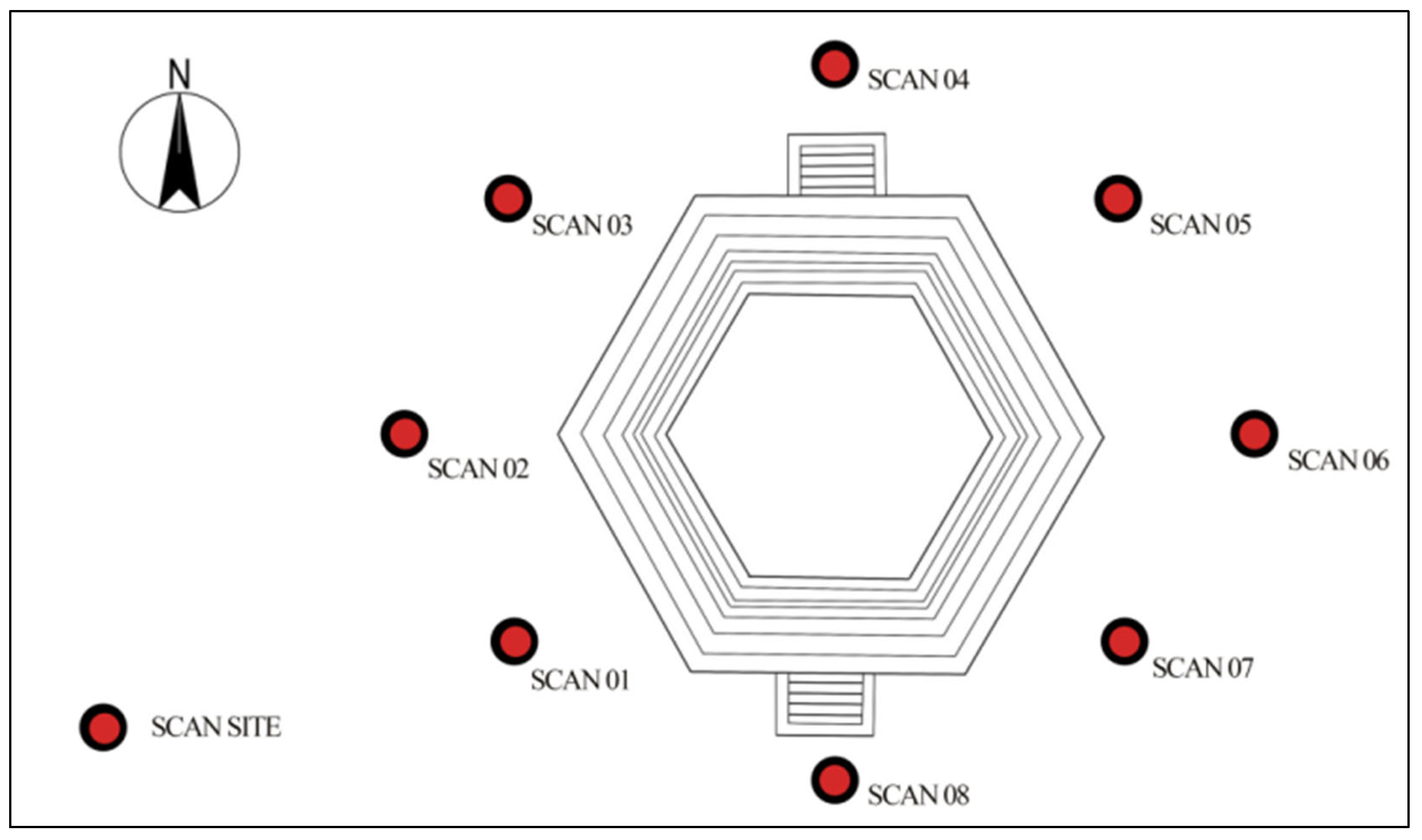
To obtain complete three-dimensional point cloud data of the pagoda without blind spots, precise scan station planning was conducted based on the on-site environment. Due to the structural instability and endangered condition of the pagoda, climbing the interior is no longer permitted. Consequently, all scanning stations were positioned around the exterior of the pagoda as shown in Figure 3. The survey was designed to ensure sufficient data overlap and completeness, and the subsequent 3D model reconstruction was based entirely on the external morphology and surrounding scene of the pagoda. Multiple scans were performed at each station, and targets were placed to facilitate subsequent automatic registration of multi-station data.

3.2. Data Processing Algorithms

After data acquisition, the raw point cloud data are further processed to remove noise and merge individual scans into a unified coordinate system. The acquired raw data contain noise and originate from multiple independent coordinate systems, requiring a series of processing steps before they can be used for three-dimensional reconstruction. The core data processing workflow of this study includes denoising, registration and fusion, and surface reconstruction.
The purpose of data denoising is to eliminate noise points in the raw data, which are often caused by environmental interference and equipment vibration, thereby improving the accuracy of subsequent processing [28]. In this study, a Gaussian filtering algorithm is employed to suppress noise in the point cloud data. The mathematical formulation of the algorithm, including the weight calculation and smoothing process, is provided in Appendix A.1 (Equations (A1) and (A3)).
The purpose of data fusion is to unify the point cloud data from multiple scanning stations into a common coordinate system for registration. In this study, the Iterative Closest Point (ICP) algorithm is employed to achieve high-precision automatic registration. The specific workflow of data fusion is as follows:
T n e w = arg min T i | | T P i s P i t | | 2
where T denotes the transformation matrix from the source point cloud to the target point cloud (including rotation and translation), P i s represents a point in the source point cloud, P i t represents a point in the target point cloud, and | | | | denotes the Euclidean distance.
The transformation T n e w that minimizes the error is computed as follows:
T n e w = T + Δ T
All points in the source point cloud are then updated by applying the transformation T n e w .
The above iterative process is repeated until the transformation T converges or the maximum number of iterations is reached.
The purpose of surface reconstruction is to generate a continuous surface model from discrete point cloud data, which is a critical step in three-dimensional modeling. In this study, the Poisson surface reconstruction algorithm is employed [29]. This algorithm converts the point cloud data into an indicator function and reconstructs an implicit surface by solving the corresponding Poisson equation. It is particularly effective in generating smooth, feature-preserving, and watertight mesh models from noisy point clouds, making it well suited for the research object in this study. The surface reconstruction process is as follows:
S = arg min s s z 2 d S + λ Ω Z Z s a m p l e 2 d Ω
where S represents the reconstructed surface, z denotes the gradient of surface Z , λ is the regularization parameter that controls the balance between smoothing and data fitting, Z s a m p l e represents the sampled height values in the point cloud data, and Ω denotes the support domain of the point cloud data.
The energy function of the Poisson reconstruction is discretized and transformed into a system of linear equations as follows:
L + λ I Z = F
where L is the matrix defined by the surface gradients and the relationships between neighboring points, I is the identity matrix, Z is the vector of unknown surface height values, and F is the force vector defined by the point cloud data. The surface is then updated and solved iteratively until the convergence criteria are satisfied or the predefined maximum number of iterations is reached.
Gaussian filtering and perspective projection, as standard algorithms in computer vision and 3D reconstruction, were applied to process the point cloud data [30,31]. The Gaussian filter was configured with a window size of 5 × 5 to enhance point cloud features and reduce noise in the captured data. The perspective projection matrix was calibrated based on the geometry of the Fuliang Red Pagoda, specifically adjusting for the building’s intricate structure to improve alignment accuracy. These choices were essential for accurate reconstruction, ensuring that no information was lost in the process. The Gaussian filtering step was followed by the application of perspective projection, designed to align the point cloud with the reference geometry. The calibration of the projection matrix took into account specific architectural features, optimizing the reconstruction process.

3.3. Three-Dimensional Modeling

After completing the preprocessing of point cloud data, this study proceeds to the three-dimensional modeling stage. This stage aims to convert the processed high-precision point cloud data into a three-dimensional polygonal model with both visual realism and geometric accuracy. The final point cloud data are exported in compatible formats (.pts or .las) and imported into the 3D modeling software SketchUp (SU) Pro 2022. The point cloud processing module of the software is capable of recognizing and displaying large-scale data points. Based on clearly identifiable boundary features in the point cloud data, operators first use the “Line” tool in the software to accurately draw the planar contour lines of each level of the Fuliang Red Pagoda. On the basis of these contour lines, tools such as “Push/Pull” are utilized to generate three-dimensional volumes of the main structural components, including the pagoda body, eaves, and platforms, according to the vertical height information provided by the point cloud. For the octagonal plan characteristic of the Fuliang Red Pagoda, precise adjustments of edge angles and distances are performed to achieve accurate reconstruction. Subsequently, the initially generated volumes are further refined by adding detailed architectural elements such as dougong (bracket sets), doors and windows, and relief decorations. During this process, continuous cross-referencing with point cloud data, high-resolution on-site photographs, and historical documentation is conducted to ensure that all detailed components conform to the morphological and proportional characteristics of Song Dynasty architecture.
After completing the geometric structure of the model, texture mapping is performed to enhance visual realism. The texture images obtained earlier through high-resolution photogrammetry are processed in Photoshop through cropping, correction, and color normalization. These processed texture images are then accurately mapped onto the corresponding surfaces of the model using the “projected texture” function in SketchUp. This step faithfully reproduces the material texture, color variations, and historical weathering characteristics of the Red Pagoda’s brickwork, serving as a key factor in achieving an immersive VR experience.
To ensure smooth operation of the model in the VR environment, optimization of high-polygon models is required. While preserving visual details, mesh density in non-critical areas is appropriately reduced using mesh simplification tools within the software. Finally, the model’s dimensions, proportions, and spatial relationships are rigorously verified to ensure high consistency with the original point cloud data and the actual structure, thereby providing an accurate and efficient digital model for subsequent VR applications.

3.4. VR Environment Development and Interaction Algorithms

To achieve interactive visualization and analysis in the VR environment, geometric transformations and rendering algorithms are employed to enable interaction with the established 3D model [32]. In interaction design, it is necessary to consider the operational logic and feedback mechanisms of the interface, which involve aspects such as user interface layout, graphical representation, and interaction logic, in order to ensure that users can quickly understand and manipulate objects within the virtual environment [33]. After the VR model is constructed, the three-dimensional model is exported into a format suitable for use in the VR environment and integrated into the virtual scene. The application of conservation and restoration of the Fuliang Red Pagoda within the VR environment involves multiple algorithms and mathematical formulations, including the implementation of changes in user perspective, as well as model translation, rotation, and scaling [34].
In architectural VR, when a user moves within the virtual environment, the position of the model relative to the user must be updated through translation. Translation refers to moving the model a specified distance along a given direction. Let P x , y , z denote the original coordinate point and T = t x , t y , t z denote the translation vector; the coordinates P after translation can be calculated as follows:
P x , y , z = P x , y , z + T t x , t y , t z x = x + t x y = y + t y z = z + t z
The translation matrix T can be expressed as:
T = 1 0 0 t x 0 1 0 t y 0 0 1 t z 0 0 0 1
In architectural VR, users may need to rotate their viewpoint around a specific axis to observe different sides of the building. Rotation can be performed around a given X , Y , Z . The matrix representation of rotation about the Z is as follows:
R z θ = cos θ sin θ 0 0 sin θ cos θ 0 0 0 0 1 0 0 0 0 1
If point P is rotated by an angle θ around the Z , the new point P can be calculated using the following formula:
P x , y , z = R z θ P x , y , z x = x cos θ y sin θ y = x sin θ + y cos θ z = z
Structural stability analysis is a critical step in evaluating the mechanical performance of architectural heritage before and after restoration interventions. In assisting conservation restoration within the VR environment, the Finite Element Method (FEM) is employed to simulate and analyze structural stability. To support conservation-oriented analysis, a finite element model of the Fuliang Red Pagoda was established for preliminary structural assessment and visualization within the VR environment. The finite element analysis was carried out using ANSYS software (version 2022 R1), and the model geometry was derived from the three-dimensional survey data obtained through terrestrial laser scanning and photogrammetric reconstruction.
Since destructive testing was not permitted for this historic masonry structure, the material properties were not determined through in situ mechanical testing, but were assigned with reference to published values for comparable historic brick masonry structures. The analysis adopted a linear elastic constitutive assumption, and the main material parameters included elastic modulus, Poisson’s ratio, and density.
For boundary conditions, the base of the pagoda was assumed to be fully fixed. Soil–structure interaction, internal material discontinuities, and local degradation effects were not explicitly considered in the present model. The loading conditions were limited to self-weight and simplified static actions for preliminary evaluation. Therefore, the FEM module in this study was intended primarily as an analytical aid for comparative visualization and decision support within the VR platform, rather than as a full structural diagnosis of the actual mechanical condition of the pagoda.
The global stiffness matrix (Stiffness Matrix) is computed, where K denotes the global stiffness matrix, B is the shape function matrix, D is the material elasticity matrix, and Ω represents the area or volume of the element:
K i j = Ω B m T D B n d Ω
The displacement boundary conditions and loads are applied, where F is the external load vector, N i is the shape function, f represents the surface load, and b denotes the body force:
F i = r N i f d T + Ω B i T b d Ω
The displacement vector (Displacement Vector) is defined as follows, where u i represents the displacement of the nodes:
U = u 1 , u 2 , , u n T
The linear system of equations is solved using an iterative method:
K U = F
If the structural response does not meet actual observations or safety standards, the material properties or loading conditions are updated, and the assembly and solution process is repeated until the convergence criteria are satisfied.
After performing the above transformations, perspective projection is further applied to simulate the effect of a camera observing the three-dimensional world. The mathematical formulation of the projection, including the transformation and projection equations, is provided in Appendix A.2 (Equations (A4) and (A5)).
To further provide intuitive interactive feedback and depth perception, enabling users to obtain a richer and more immersive experience in the virtual environment, the study further optimizes the ambient lighting and diffuse lighting parameters of the model.
I a m b i e n t = k a m b i e n t I l i g h t
where I a m b i e n t denotes the ambient lighting intensity, k a m b i e n t is the ambient reflection coefficient, and I l i g h t represents the light source intensity.
I = k d I L max 0 , cos θ
where I denotes the final lighting intensity, k d is the diffuse reflection coefficient, I L represents the light source intensity, and θ is the angle between the incident light ray and the surface normal, cos θ which can be calculated using the dot product of the normal vector and the light direction vector.
L o v = Ω f r l , v L i l n l d w i
The reflection equation is used to calculate the reflection of light on a surface, where L o ( v ) denotes the intensity of the outgoing light, f r ( l , v ) is the bidirectional reflectance distribution function (BRDF), L i ( l ) represents the intensity of the incoming light, n is the surface normal, l is the direction of the incoming light, v is the direction of the outgoing light, Ω denotes the solid angle over the hemisphere, and d w i is the differential element of the solid angle.
The geometric reconstruction of the Fuliang Red Pagoda was achieved through high-precision point cloud registration, followed by meshing to generate the 3D model. The iterative closest point (ICP) algorithm was applied to align multiple point clouds obtained from different scanning stations. The mean ICP registration error was calculated as 2.4 mm (standard deviation = 0.8 mm) across all scans, indicating a high degree of accuracy in the point cloud alignment. To assess the quality of the geometric reconstruction, we compared the final point cloud with real structure measurements. The standard deviation between the reconstructed point cloud and the reference data was found to be 3.1 mm. Additionally, the fidelity of the mesh model to the raw point cloud was evaluated using Hausdorff distance, with a maximum deviation of 4.5 mm, confirming the model’s high precision in representing the building’s geometry. These quantitative metrics—ICP registration error, point cloud standard deviation, and mesh fidelity—demonstrate the robustness of the geometric reconstruction process.

3.5. Overall Technical Framework

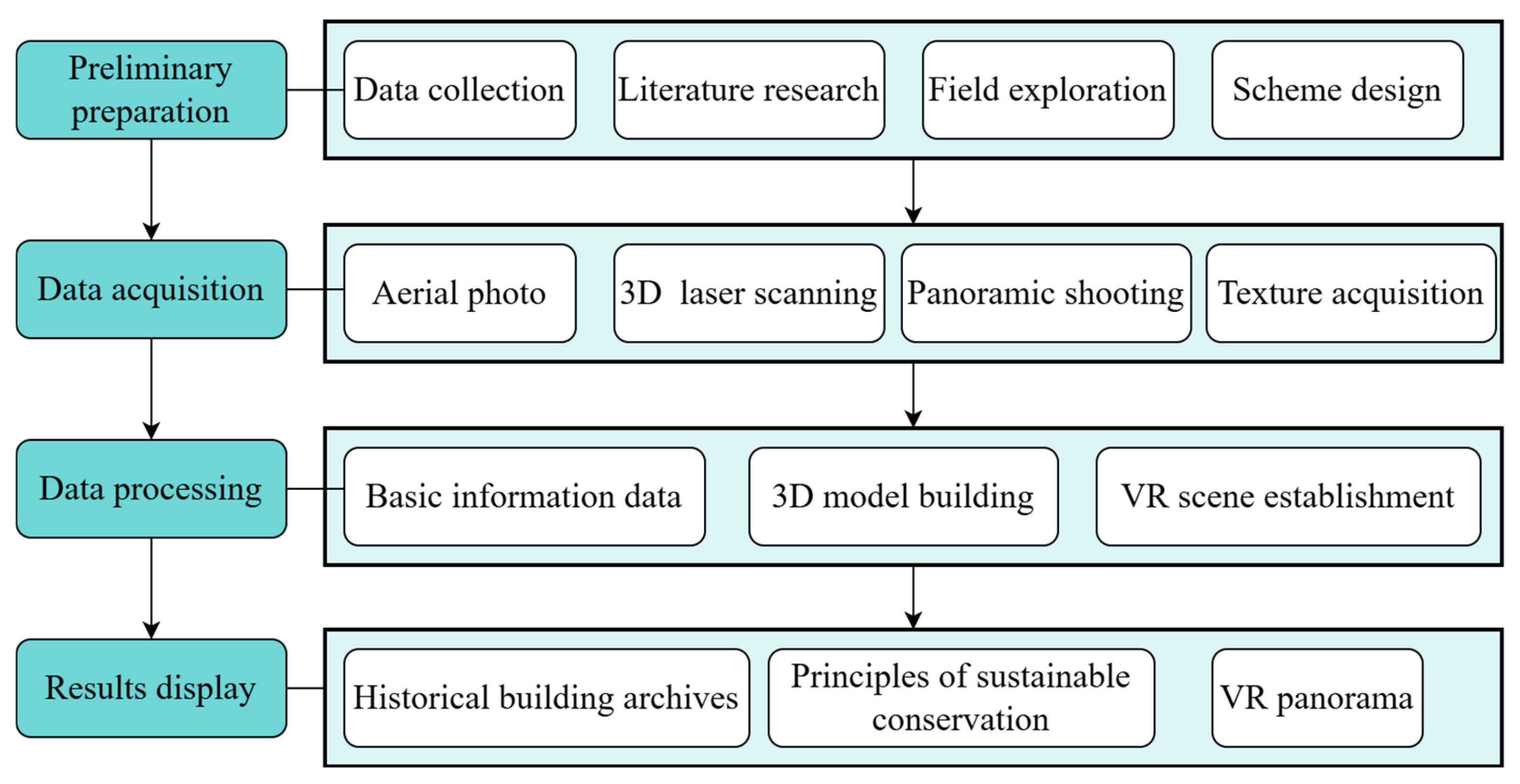
To break through the fragmented technical path of traditional architectural heritage digitization research, which separates “data acquisition–model construction–application presentation,” this study constructs a systematic technical framework aimed at supporting conservation decision-making (Figure 4). The framework consists of four stages: preparation, data acquisition, data processing, and result presentation. At the methodological level, it emphasizes multi-source data fusion, high-precision reconstruction control, and the coupling mechanism of structural analysis and virtual interaction, forming a closed-loop technical system from information acquisition to conservation evaluation.
The experimental technical pathway mainly includes the following aspects:
(a) A high-precision acquisition mechanism driven by multi-source data collaboration. Unlike single-method approaches such as terrestrial laser scanning or photogrammetry alone, this study constructs an integrated data acquisition strategy combining UAV aerial survey, terrestrial laser scanning, and panoramic texture capture. Through coordinated air–ground data acquisition, both the overall spatial structure and local detailed information are simultaneously captured. This strategy not only improves the completeness of point cloud coverage but also enhances geometric constraint capability during subsequent data fusion, thereby effectively reducing systematic errors caused by single data sources.
(b) A coupling mechanism between geometric reconstruction and structural assessment. During the data processing stage, the study performs geometric modeling procedures including point cloud denoising, ICP fine registration, and Poisson surface reconstruction, while also introducing Finite Element Method (FEM) analysis into the VR environment to integrate structural stability simulation with interactive visualization. Traditional 3D reconstruction studies often remain at the level of morphological restoration; in contrast, this study embeds structural mechanics analysis into the VR system, enabling the digital model to possess not only visual realism but also structural evaluation capability. By simulating structural responses under different restoration strategies within the virtual environment, a dynamic coupling process of “morphological reconstruction–mechanical assessment–scheme comparison” is achieved. This approach overcomes the limitation of digital models as mere visualization tools and transforms them into analytical platforms for conservation decision support.
(c) Preliminary user experience evaluation of the VR system. To assess the usability, immersion, interactivity, functional completeness, and overall satisfaction of the developed VR system, a preliminary user experience evaluation was conducted with 12 participants. The participants included university students majoring in computer-related disciplines and VR technology developers, all of whom had prior experience with VR equipment ranging from 6 months to 2 years. Although not all participants were professional heritage conservators, their familiarity with VR devices and interactive systems enabled them to provide informed feedback on the operational performance and experiential quality of the system. The evaluation consisted of a questionnaire covering five dimensions: usability, immersion, interactivity, functionality, and overall satisfaction. Each dimension was rated on a 1–5 Likert scale, where 1 represented “very dissatisfied” and 5 represented “very satisfied.” Semi-structured interviews were also conducted to collect qualitative feedback on participants’ interaction experience, perceived system advantages, and suggestions for improvement. The questionnaire results were analyzed by calculating the mean score and standard deviation for each dimension. Given the limited sample size and exploratory nature of the evaluation, the results are interpreted as preliminary user feedback rather than statistically generalizable evidence.
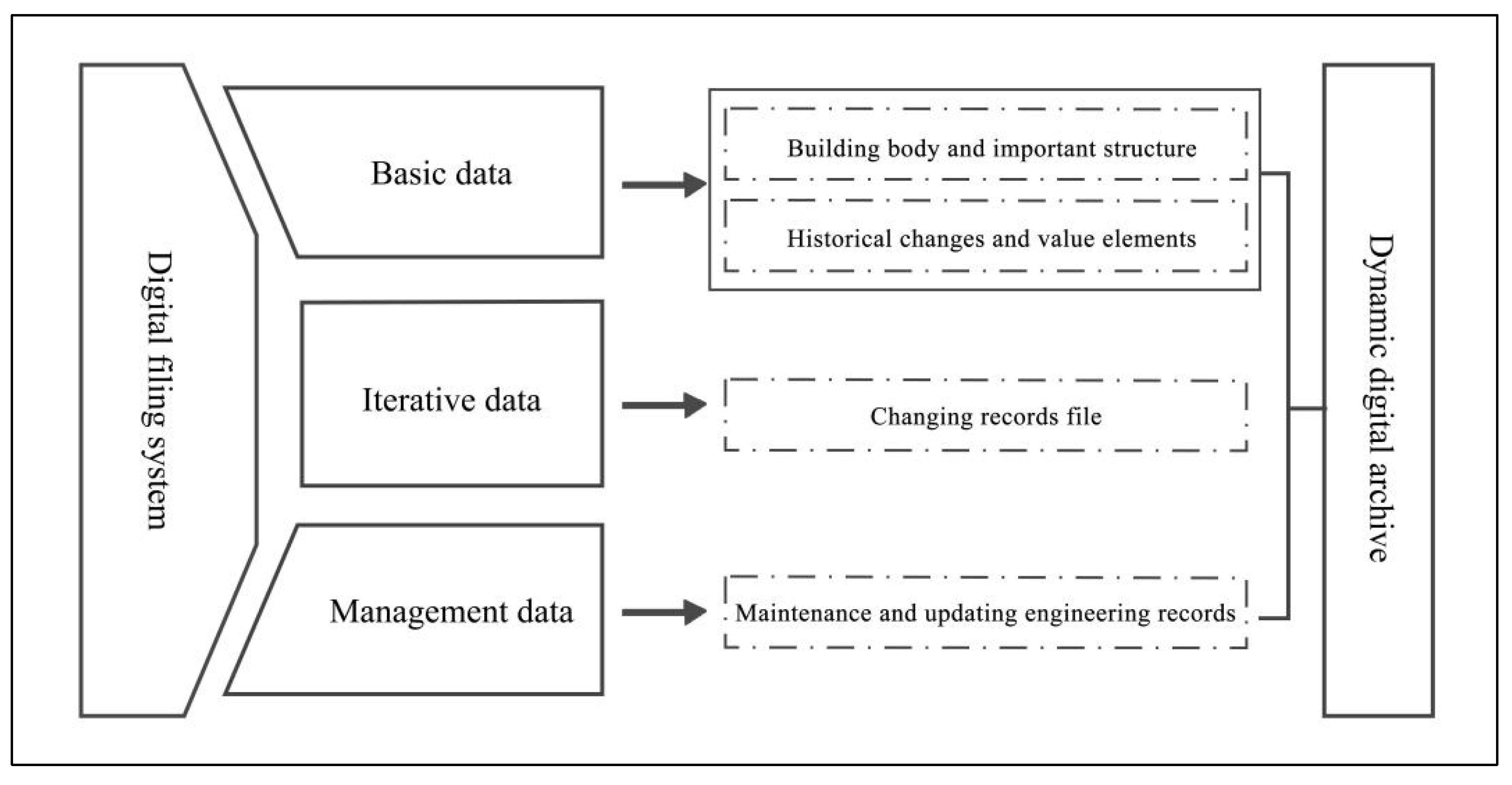
(d) A closed-loop conservation model integrating digital archiving, restoration assistance, and public participation. In the result presentation stage, this study proposes a three-level application structure based on digital archiving, centered on restoration assistance, and extended to public dissemination. By establishing a digital archive system capable of long-term storage and reuse, sustainable preservation of heritage information is achieved; through the function of virtual restoration scheme switching, visual comparison and selection of restoration strategies are enabled; and through immersive VR presentation, public engagement and cultural identity are enhanced. This structure forms a closed-loop pathway from professional conservation decision-making to public dissemination, enabling digital technologies to serve not only technical conservation practices but also cultural heritage transmission at the societal level.
Compared with traditional single-point digital reconstruction studies, the innovation of this research lies in the construction of a replicable and scalable overall technical framework. This framework integrates precision control, structural assessment, and interactive dissemination, achieving systematic application of digital technologies in architectural heritage conservation while adhering to the principles of authenticity and minimum intervention. The proposed workflow demonstrates strong general applicability and can be extended to the digital conservation of other masonry pagodas or complex historic buildings, providing methodological references for the transition of digital heritage conservation from “documentation-oriented” to “decision-support-oriented” approaches.

4. Results

4.1. VR Model Construction Results

The construction of the VR model is a key step in the digitalization of the Fuliang Red Pagoda, involving three main stages: data acquisition, data processing, and three-dimensional modeling. In response to the unique architectural characteristics of the pagoda, such as its octagonal structure, this study employs terrestrial laser scanning technology for data acquisition. By emitting laser pulses and measuring the time taken for the reflected signals to return, spatial coordinate information of the object surface is obtained, enabling rapid and accurate acquisition of three-dimensional geometric data of the structure [35]. Prior to scanning, on-site surveying is conducted, and scanning devices are strategically arranged at multiple locations around the structure according to the actual environmental conditions to ensure comprehensive coverage and complete data acquisition.
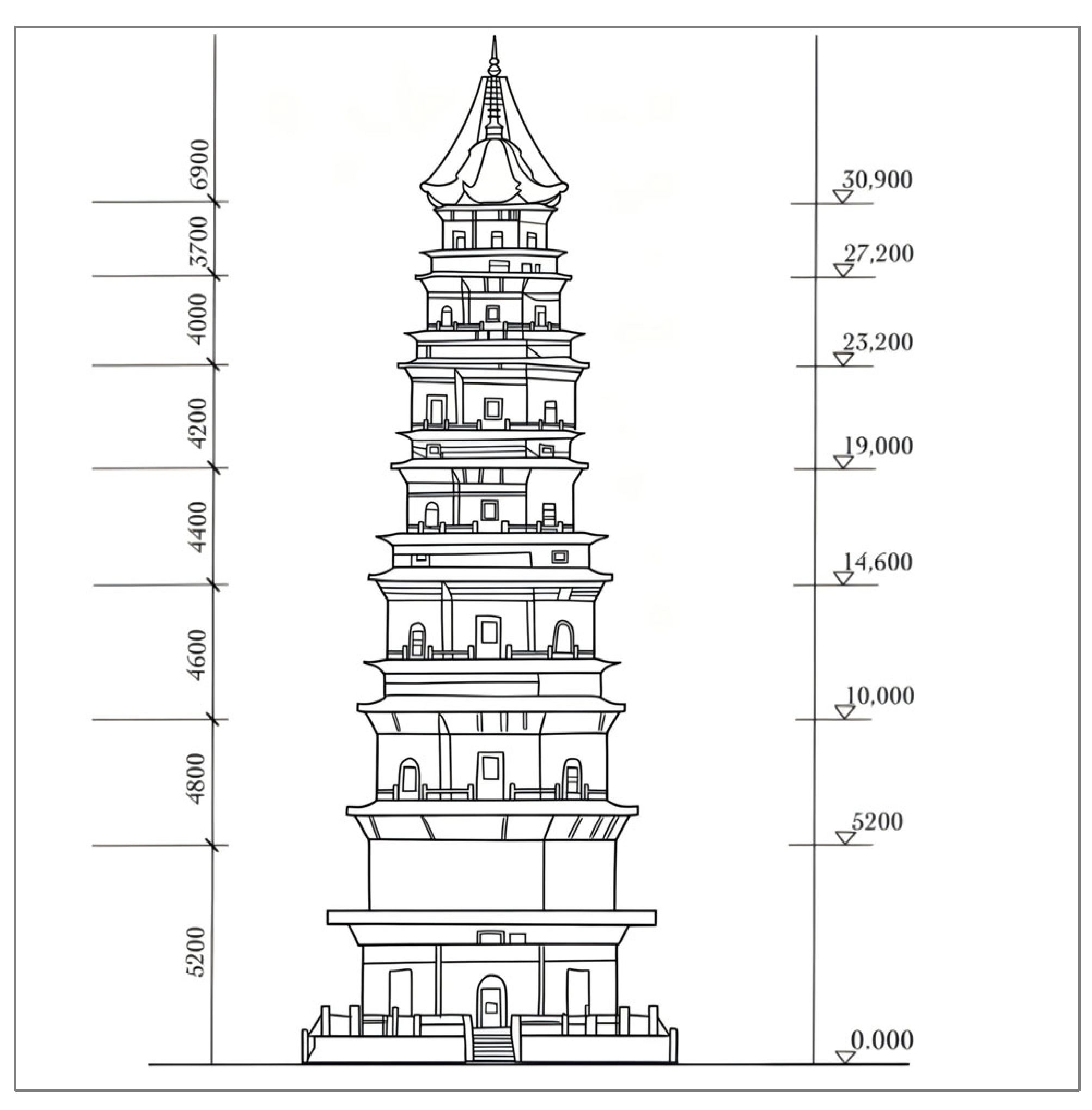
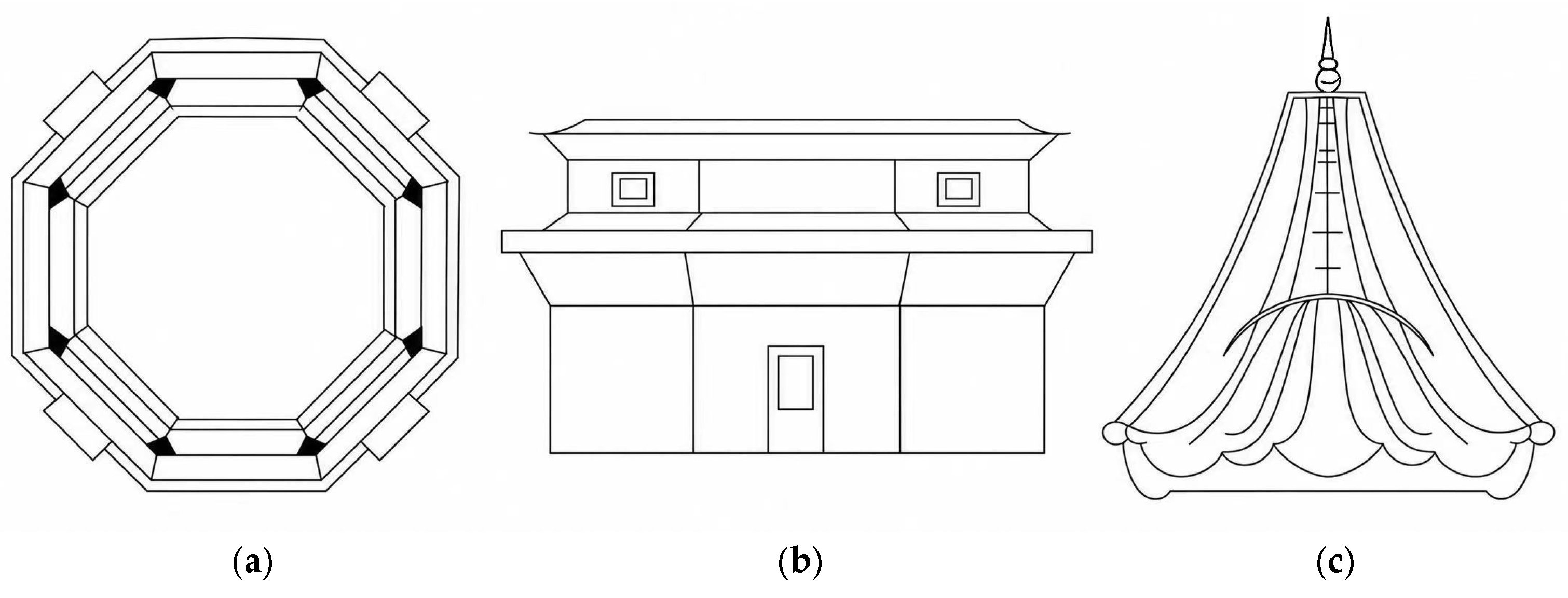
The three-dimensional laser scanning process generates point cloud data, from which the planar contour dimensions of the Fuliang Red Pagoda can be derived, as shown in Figure 5. In addition, through synchronized high-precision photogrammetry, realistic texture information of the pagoda surface, including color, material properties, and weathering traces, is captured.
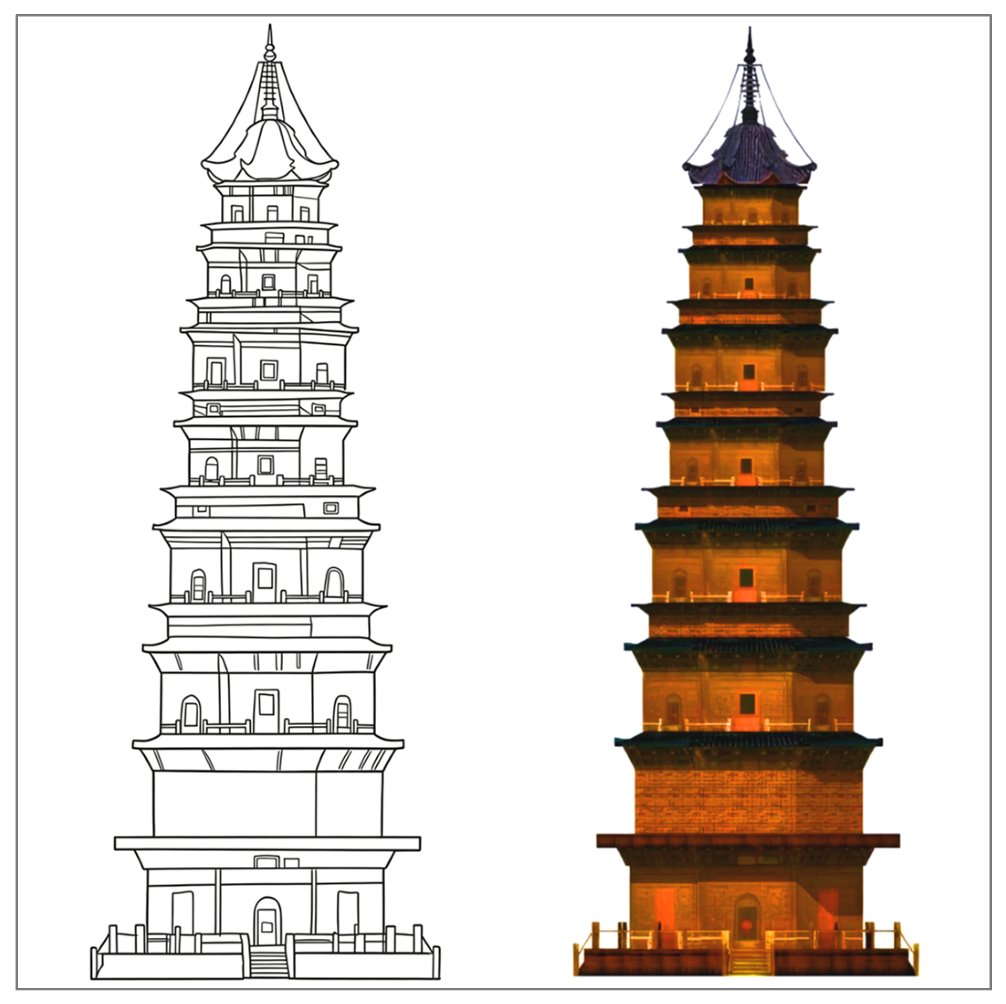
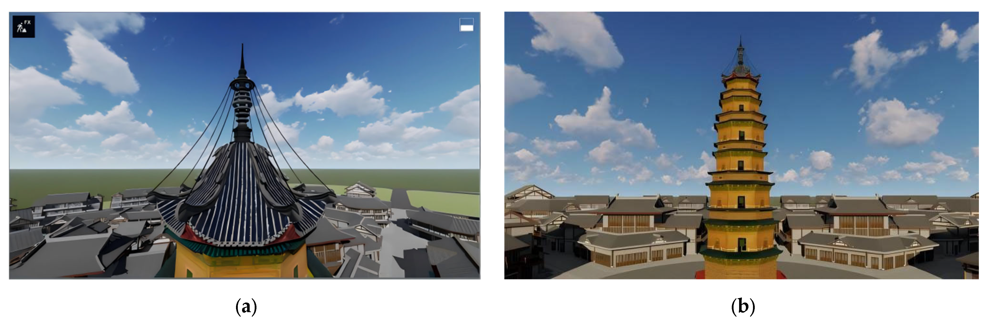
After completing data preprocessing, the building model is further constructed using computer-based modeling software. The data are converted into a recognizable format, and based on information such as planar layout and vertical height contained in the dataset, the general contour lines of the structure can be generated [36]. On the basis of these preliminary contours, and according to the octagonal plan layout and vertical height data of the pagoda, modeling tools are used to carefully delineate the initial three-dimensional form of the Fuliang Red Pagoda. Subsequently, the structural details of the pagoda are further refined by constructing key components such as the pagoda body and eaves (as shown in Figure 6), followed by smoothing operations to achieve a more refined appearance.
After establishing the basic shape and structural elements of the three-dimensional model, the previously acquired texture images are proportionally mapped onto the model, and further detailed sculpting and refinement of fine structural components are carried out (Figure 7). By integrating historical documents and archeological data, the model is ensured to be consistent with historical context in both style and detail. To guarantee the integrity and accuracy of the three-dimensional model, periodic checks of dimensions and proportions are conducted during the modeling process to ensure consistency with the original data. The polygon count and complexity are optimized to ensure smooth rendering across different platforms [37].

4.2. Implementation of VR Scene Interaction and User Experience

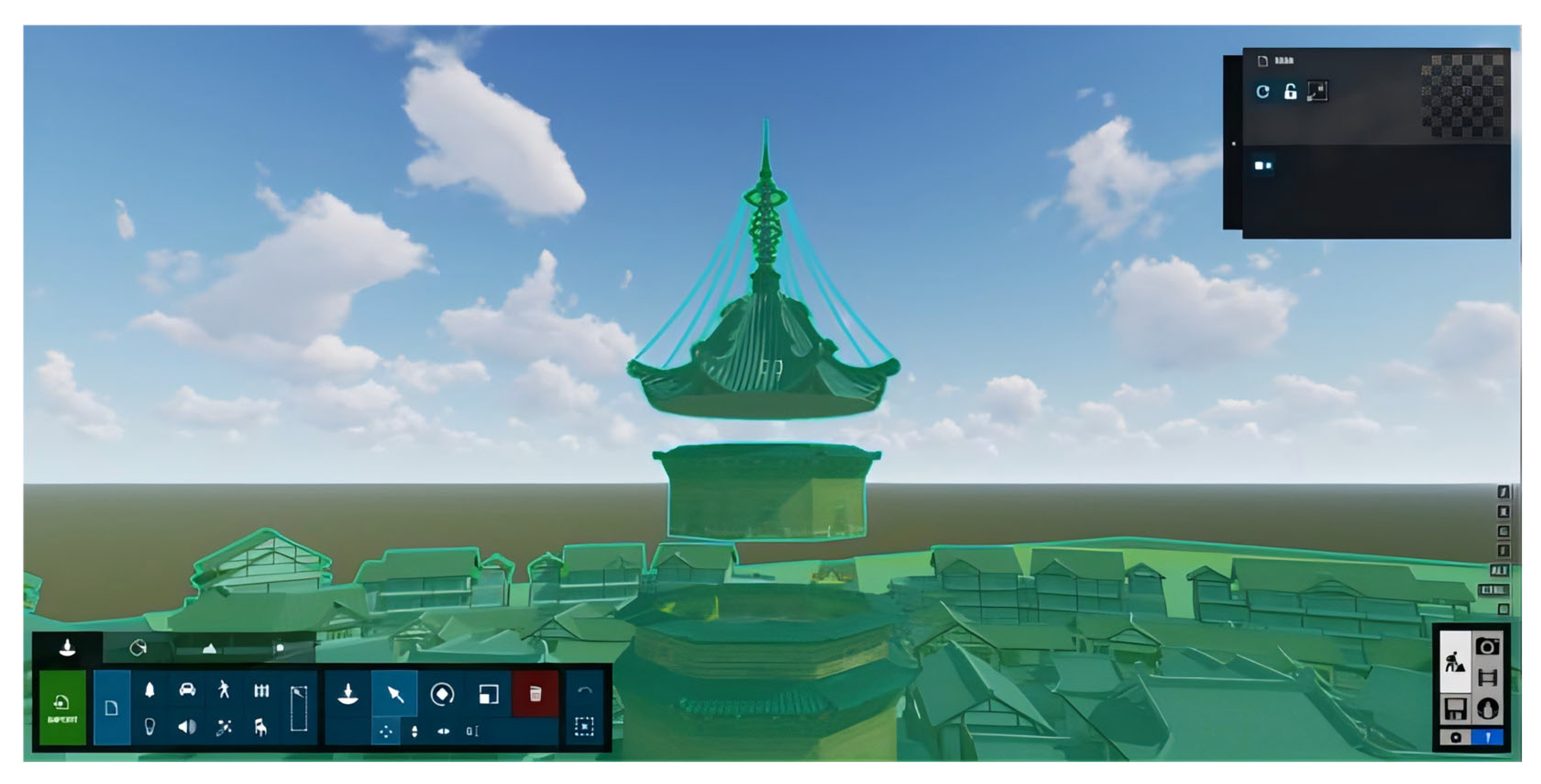
In terms of VR scene interaction and user experience, this study develops and deploys an immersive VR interactive system. The system enables architectural visualization and user interaction, providing a comprehensive digital platform for the conservation assessment and virtual presentation of the Fuliang Red Pagoda. The VR system implements the following core interactive functions: free navigation, allowing users to walk or fly freely within the virtual environment via controllers, observing the overall form of the pagoda and its surrounding spatial context from any angle and distance; model manipulation, enabling users to translate, rotate, and scale either the entire structure or individual components for detailed inspection; information query, where a built-in information database allows users to select specific components (such as eaves or dougong) using a laser pointer, triggering the UI to display metadata including name, historical background, and conservation status; and virtual restoration scheme switching, where multiple predefined restoration scenarios for damaged parts of the pagoda are provided, allowing users to switch between schemes in real time via a menu and visually compare the effects of different materials and techniques.
The performance test was conducted on a workstation equipped with an NVIDIA GeForce RTX 3080 GPU, an Intel Core i7-12700K CPU, 32 GB of RAM, and an HTC Vive Pro 2 headset. As shown in Table 2, the VR interactive system achieved an average rendering frame rate of 92 FPS under full-scene load and a motion-to-photon latency of 18 ms. These results suggest that the system can support smooth real-time rendering and responsive immersive interaction, helping to reduce user discomfort such as motion sickness during long-duration VR experiences. In addition, the tracking accuracy of less than 2 mm and the user interface response time of less than 50 ms further indicate the stability and responsiveness of the system.
As shown in Table 3, the preliminary user experience evaluation involving 12 participants indicated generally positive feedback on the VR system, particularly in terms of immersion and overall satisfaction.
The participants, consisting of university students majoring in computer-related disciplines and VR technology developers with 6 months to 2 years of VR equipment usage experience, rated system usability with an average score of 4.2 (standard deviation = 0.75), suggesting that the system was generally easy to operate and navigate. The immersion dimension received the highest mean score of 4.4 (standard deviation = 0.51), indicating that the VR environment provided a strong sense of presence and user engagement. The interactivity dimension scored 4.0 on average (standard deviation = 0.63), reflecting acceptable responsiveness and user control during system operation, although some participants suggested that the navigation logic could be further optimized. The functionality dimension, which assessed the completeness of system features for conservation-related visualization and decision support, received a mean score of 4.3 (standard deviation = 0.58). Overall satisfaction was also rated highly, with an average score of 4.4 (standard deviation = 0.51), indicating that the participants considered the system useful for visualizing architectural heritage conservation scenarios. Qualitative feedback from the semi-structured interviews further suggested that the clarity of certain visual details in the 3D model could be enhanced and that some parts of the VR interface would benefit from more intuitive navigation guidance.

4.3. VR Scene Visualization

Furthermore, the three-dimensional model of the Fuliang Red Pagoda is imported into a VR development platform. The platform provides tools and functionalities required for constructing complex scenes. These tools are utilized to configure the scene layout, ensuring coordination between the pagoda model and its surrounding environment, as well as accurate positioning within the virtual space [38]. The visual effects of the scene are further optimized by adjusting lighting, shadows, and post-processing effects to enhance realism. Finally, by simulating natural lighting conditions such as sunlight and sky reflections, the visual impact and depth perception of the Red Pagoda are significantly improved. The VR scene visualization is shown in Figure 8.
After completing the construction of the three-dimensional model and the VR scene setup, this study further extends the functional capabilities of the system, transforming it from a purely visual presentation platform into a decision-support tool with comprehensive evaluation capabilities. Unlike traditional virtual display systems that focus solely on visual representation, this study integrates a Finite Element Method (FEM) module into the VR environment, combining structural stability analysis results with an immersive interactive interface to achieve synchronized feedback between mechanical performance and visual representation. Based on the FEM computational framework established in Equations (12)–(15), the system performs stiffness matrix assembly, boundary condition application, and displacement response calculation for key structural components of the pagoda, and maps the computed structural response results onto the surface of the three-dimensional model in real time. Through visual techniques such as color grading, transparency variation, and component highlighting, the system intuitively presents stress distribution and deformation trends under different restoration schemes. At the same time, the system supports switching between different material parameters and loading conditions, enabling users to conduct comparative analyses of multiple conservation intervention strategies within the virtual environment.
In addition, considering that architectural heritage conservation involves not only structural safety but also the preservation of historical appearance and esthetic suitability, this study introduces a visual suitability evaluation module into the system. By simulating different restoration materials, component replacement methods, and color adjustment schemes within the virtual environment, users can intuitively assess the degree of consistency between proposed interventions and the original architectural style, thereby achieving a balanced evaluation between structural safety and visual integrity.
As shown in Figure 9, the structural-response layer is presented for demonstrative decision-support visualization and does not constitute a full nonlinear diagnosis of the masonry structure. The VR system interface supports model layer control and independent component analysis functions. Researchers can individually activate or hide different levels of the pagoda and perform both structural and visual evaluations on specific components. This “layer–component–multi-parameter” interaction approach makes the evaluation process of conservation schemes more refined and controllable. Through the above mechanisms, this study achieves the coupled application of structural mechanics analysis and esthetic evaluation within a virtual reality environment, establishing an integrated decision-support platform that combines “morphological visualization–structural simulation–scheme comparison–comprehensive evaluation,” thereby providing a more scientific and visualized technical pathway for the conservation and restoration of architectural heritage.

5. Discussion

5.1. Reliability Analysis of Multi-Source Data Fusion and High-Precision Digital Reconstruction

The prerequisite for digital conservation of architectural heritage lies in the completeness and accuracy of geometric data. This study adopts a strategy integrating terrestrial laser scanning and close-range photogrammetry. Through the arrangement of eight scanning stations and target-based control, a high-overlap point cloud dataset is established, and Gaussian filtering is introduced in the data processing stage for noise suppression, while the ICP algorithm is employed for precise multi-station registration. Moropoulou et al. pointed out that the core value of non-destructive digital technologies in heritage conservation lies in acquiring high-precision information without interfering with the original structure [39]. In addition, the ICP algorithm solves the rigid transformation matrix by minimizing the Euclidean distance error between source and target point clouds, and its accuracy directly affects the continuity and stability of subsequent Poisson surface reconstruction.
In this study, by controlling iteration convergence conditions and error thresholds, the overall point cloud error is maintained within an acceptable range, thereby providing a reliable geometric basis for subsequent structural simulation. Compared with the air–ground integrated 3D documentation method proposed by Jo and Hong [40], this study further emphasizes the compatibility between geometric continuity and structural analysis requirements. The Poisson surface reconstruction algorithm generates watertight mesh models by solving the Poisson equation of an implicit function. Compared with traditional triangular mesh interpolation methods, it demonstrates higher tolerance to noisy data and better preserves the overall smoothness of complex masonry surfaces, which is particularly important for ancient brick pagodas with repetitive components and intricate textures.

5.2. Technical Rationality of Coupling Geometric Models with Structural Simulation

Masonry pagodas may develop structural risks under long-term loading and environmental effects. Shang and Chang indicated that seismic behavior analysis of Chinese masonry pagodas should be based on numerical simulation considering actual structural characteristics [12]. Based on Equations (12)–(15), this study establishes a finite element analysis framework and embeds stiffness matrix assembly, load application, and displacement solution processes into the VR environment, achieving real-time coupling between geometric models and structural simulation. Traditional structural analysis results are often presented as two-dimensional contour plots or tables, which makes it difficult to intuitively represent the mechanical relationships among spatial components. Moreover, as emphasized in studies on digital heritage repositories and platforms, the long-term value of three-dimensional heritage data depends not only on accurate documentation but also on its organized storage, visual interpretation, accessibility, and reuse [41]. In this study, nodal displacement and stress distribution are mapped onto the surface of the three-dimensional model and visualized through color gradients and transparency variations, enhancing spatial readability of structural responses. The VR system supports switching between different material parameters and boundary conditions, enabling comparative analysis of multiple restoration strategies within a unified platform. This multi-parameter control mechanism transforms conservation decision-making from qualitative judgment to semi-quantitative analysis, facilitating risk assessment under the framework of the “minimum intervention principle.” It should be noted that this study adopts a linear elastic assumption for structural analysis and does not consider material nonlinearity or long-term damage evolution. FEM analysis was applied to evaluate the structural behavior of the pagoda under different loading conditions. It should be noted, however, that the masonry structure of historic buildings is inherently heterogeneous, nonlinear, and often affected by material degradation and existing cracks, which limits the accuracy of FEM in predicting exact structural responses. Therefore, the FEM results in this study are used primarily as a comparative and visual tool to assess potential interventions and to guide decision-making, rather than as precise predictions of material behavior. When combined with virtual reality (VR) visualization of structural responses, FEM provides a dynamic framework for evaluating multiple restoration scenarios and identifying potential risks while maintaining adherence to authenticity and minimum intervention principles.
Furthermore, the FEM component should be understood as a preliminary analytical module embedded in the VR-based heritage conservation framework. For historic masonry buildings such as the Fuliang Red Pagoda, the assumption of linear elasticity inevitably simplifies the actual structural response, especially in the presence of material weathering, discontinuities, and existing cracks. Therefore, the current FEM results are more suitable for comparative visualization and intervention-oriented assessment than for precise structural diagnosis. Future work should incorporate more refined constitutive models, field-based material characterization, and nonlinear analysis to improve the engineering reliability of the simulation results.
In immersive VR systems, real-time performance and stability are key factors affecting user experience and application value [42]. Consistent with the findings of Heydarian et al. regarding the enhancement of spatial cognition through immersive virtual environments, the system developed in this study achieves real-time visualization of structural analysis results while maintaining smooth interaction performance [43]. Under full-scene load conditions, the system achieves an average rendering frame rate of 92 FPS and maintains motion-to-photon latency below 20 ms. Paladini et al. noted that immersive virtual environments can enhance the comprehensibility and accessibility of complex spatial information [44]. Kim et al. pointed out that when motion-to-photon latency exceeds 20 ms, users are prone to motion sickness and reduced immersion [45]. Therefore, this study enhances visual realism while ensuring real-time performance through optimization of lighting and rendering algorithms.

5.3. Decision-Support Mechanism and Transformation of Conservation Paradigm

Soto-Martin et al. demonstrated through digital reconstruction and immersive VR experiments of historic buildings that high-quality lighting simulation and texture mapping play a crucial role in enhancing immersive realism [46]. This study achieves comprehensive evaluation of structural safety and visual coherence through a “layer–component–multi-parameter” control mechanism. In terms of sustainable conservation, Onecha et al. emphasized that sustainability should be an important dimension in the evaluation of historic building value [47]. HBIM has demonstrated significant potential in heritage conservation by supporting the integration of multi-source data and facilitating decision-making processes. Recent bibliometric analysis highlights six emerging frontiers in HBIM research, including semantic enrichment, automated parametric modeling, and integration with virtual reality for interactive intervention simulations [48]. By simulating different intervention schemes in a virtual environment, this study achieves a balance between structural safety and sustainability principles. Compared with the HBIM platform proposed by Fadli and AlSaeed [49], this study places greater emphasis on the integration of structural simulation and immersive interactive feedback, endowing the digital system with dynamic analytical capabilities. These developments provide a methodological context for combining VR simulations with HBIM workflows, allowing the realistic evaluation of restoration proposals while ensuring that digital models serve both analytical and conservation purposes.
From the perspective of conservation philosophy, this framework contributes to the transformation of architectural heritage digital research from “documentation-oriented applications” to “decision-support systems.” By simulating different intervention schemes in advance within a virtual environment, uncertainties and trial-and-error costs during actual construction can be reduced, thereby improving the scientific rigor and transparency of conservation planning. Digital documentation is the first step in sustainable conservation, converting physical architectural heritage into high-precision digital formats, enabling scholars and experts to conduct in-depth analysis and interdisciplinary collaboration (Figure 10). In this study, a dataset is obtained through terrestrial laser scanning, and after professional data processing, a three-dimensional model is generated. This model exhibits a high degree of similarity to the original structure and can be used for interactive simulation and analysis within a virtual environment, providing important references for the sustainable conservation of the Fuliang Red Pagoda.
In addition to its documentation and archiving functions, the VR platform developed in this study provides a transformative tool for assisting conservation planning. It allows conservation practitioners to visualize, evaluate, and compare multiple intervention schemes within an immersive environment before any physical work begins, thereby adhering to the principle of minimum intervention. Within the virtual environment, restoration simulations of damaged parts of the Red Pagoda can be performed, which not only reduces direct intervention on the original structure but also provides multiple potential solutions for restoration work. In the case of the Fuliang Red Pagoda, the application of VR technology begins with comprehensive three-dimensional data acquisition of the pagoda, forming an accurate digital model. These models capture not only the external morphology of the pagoda but also its internal structure and detailed features. Using these models, researchers and experts can conduct real-time assessments of damage within the virtual environment and test different restoration materials and methods to design the most appropriate restoration schemes. This open and interactive research platform enables members of restoration teams, who may be geographically dispersed, to collaborate within the same virtual environment to discuss and adjust restoration plans in real time. This collaborative approach not only improves decision-making efficiency but also ensures the quality and effectiveness of restoration work. Through interactive devices, team members can immerse themselves in the virtual restoration environment and examine proposed interventions from multiple perspectives and levels of detail.

5.4. Research Limitations and Future Directions

Although this study establishes a relatively comprehensive digital conservation framework, several limitations remain. First, the processes of point cloud processing and component modeling still rely on manual judgment, resulting in limited automation. Future work could integrate machine learning algorithms to improve the efficiency of point cloud semantic segmentation and component recognition [50]. Second, the structural analysis in this study is primarily based on linear elastic assumptions and static conditions, without incorporating multi-physics coupling mechanisms or the effects of long-term material degradation. Previous studies have shown that the mechanical performance of historic masonry structures may significantly deteriorate under long-term coupled effects of environmental factors such as temperature and humidity variations, seismic activity, and wind loads [51]. Therefore, future research could introduce thermo-hygro-mechanical coupling models, seismic dynamic response analysis, and environmental deterioration models to achieve multi-physics simulation, thereby improving the prediction accuracy of long-term structural stability. Multi-physics numerical simulation techniques have demonstrated strong application potential in structural safety assessment of historic buildings [52], and their integration will facilitate the transition of digital models from static representation to dynamic prediction.
In addition, while the VR system in this study is mainly used for assisting structural and visual scheme comparison, its actual effectiveness in knowledge dissemination and decision optimization still requires validation through empirical studies. Relevant research indicates that the cognitive benefits of immersive virtual environments should be systematically evaluated through quantitative experimental design [53]. Therefore, future studies should incorporate user behavior data collection and controlled experimental methods to quantitatively analyze learning outcomes, depth of understanding, and decision-making efficiency, thereby strengthening the empirical support of research findings. In terms of technical workflow, although high-quality digital reconstruction is achieved, point cloud processing and three-dimensional modeling still depend on manual intervention. Particularly in stages such as component segmentation, feature recognition, and detailed reconstruction, extensive manual judgment is required, which not only reduces efficiency but may also introduce subjective bias. In recent years, deep learning-based methods for point cloud semantic segmentation and automatic feature recognition have made progress in the field of architectural digitization [54]. Integrating artificial intelligence algorithms into the heritage digital reconstruction process is expected to significantly enhance automation and objectivity, thereby establishing a more efficient and standardized digital modeling system.
It is also noteworthy that although the three-dimensional model established in this study achieves a high level of geometric accuracy and visual representation, it still lacks sufficient integration of semantic information. Currently, the model mainly represents geometric features of the structure and does not fully incorporate multidimensional information such as material properties, historical restoration records, and structural parameters. As mentioned earlier, Fadli and AlSaeed indicated that heritage building information modeling (HBIM), which integrates multi-source information, enables lifecycle management of historic buildings [49]. Therefore, integrating the HBIM framework with the high-precision three-dimensional model developed in this study would help establish a comprehensive digital platform with semantic expansion capability and information management functionality. At the level of practical application and dissemination, the current VR system requires relatively high hardware performance and graphical computing capability, which may limit its large-scale adoption. With the development of WebGL and mobile augmented reality technologies, lightweight and cross-platform deployment is becoming a prevailing trend. Hilfert and König pointed out in their study on low-cost VR systems that lightweight virtual environments can help expand the scope of technological application [55]. Future work may integrate cloud-based rendering and web-based interaction platforms to reduce hardware requirements and improve accessibility for the public.

6. Conclusions

This study focuses on the digital conservation and sustainable utilization of the Fuliang Red Pagoda as an architectural heritage site, and constructs a systematic technical framework integrating multi-source data acquisition, high-precision three-dimensional reconstruction, structural numerical simulation, and immersive virtual reality interaction. High-density point cloud data are acquired through the integration of terrestrial laser scanning and close-range photogrammetry. Combined with Gaussian filtering for denoising, ICP fine registration, and Poisson surface reconstruction algorithms, a high-precision three-dimensional model with geometric continuity and watertight topology is achieved. On this basis, the study embeds finite element analysis into the VR environment, mapping stiffness matrix assembly, load application, and displacement solution results onto the three-dimensional model in real time, thereby realizing the coupled visualization of structural response and spatial representation. Experimental results indicate that under full-load operation, the system achieves an average frame rate of 92 FPS and maintains motion-to-photon latency below 20 ms, meeting the requirements for stability and comfort in immersive interaction. Through a “layer–component–multi-parameter” interaction control mechanism, the study establishes a comprehensive decision-support platform integrating morphological visualization, structural evaluation, and scheme comparison. Compared with traditional digital documentation studies, this research goes beyond the conventional “data acquisition–model presentation” workflow by integrating geometric reconstruction, structural analysis, and interactive decision-making into a closed-loop system. Its primary innovation lies in the use of virtual reality (VR) to realistically simulate multiple intervention and restoration proposals, allowing stakeholders to evaluate potential conservation strategies dynamically before any physical intervention. While adhering to the principles of authenticity and minimum intervention, this technical framework transforms digital models from static recording tools into dynamic analytical and decision-support platforms. It provides a replicable and scalable methodological pathway for the high-precision digital conservation of complex historic buildings, such as masonry pagodas, and offers practical support for applying digital technologies to heritage conservation decision-making.
Although this study verifies the feasibility of multi-source integrated modeling and VR-based structural coupling applications, several limitations remain. First, point cloud processing and three-dimensional modeling still require significant manual intervention, resulting in limited automation. Second, the structural analysis is based on linear elastic assumptions and does not yet incorporate multi-physics coupling or long-term material degradation mechanisms. Finally, the effectiveness of the VR system in knowledge dissemination and decision-making improvement still requires systematic quantitative validation through user-based experimental studies. Future research will focus on integrating artificial intelligence algorithms to enhance automatic point cloud segmentation and feature recognition, thereby establishing more efficient digital reconstruction workflows. Furthermore, the integration of multi-physics simulation techniques with HBIM semantic models will be explored to achieve structural prediction and lifecycle information management. Finally, by developing lightweight and cross-platform application solutions, digital models of architectural heritage are expected to evolve from “representation tools” to “predictive tools,” providing more comprehensive and scientific technical support for the transition of heritage conservation from passive restoration to proactive risk prevention.

Author Contributions

Conceptualization, Y.C. and Y.W. (Yangyang Wei); methodology, L.C. and Y.C.; software, L.C. and Y.W. (Yihan Wang); validation, Y.W. (Yangyang Wei), L.C. and Y.C.; formal analysis, L.C. and Y.W. (Yihan Wang); investigation, L.C. and Y.C.; resources, L.C. and Y.W. (Yangyang Wei); data curation, L.C. and Y.W. (Yihan Wang); writing—original draft preparation, L.C. and Y.W. (Yangyang Wei); writing—review and editing, Y.W. (Yihan Wang); visualization, L.C., Y.C. and Y.W. (Yihan Wang); supervision, L.C. and Y.W. (Yangyang Wei); project administration, L.C. and Y.W. (Yangyang Wei); funding acquisition, Y.W. (Yangyang Wei) and Y.W. (Yihan Wang). All authors have read and agreed to the published version of the manuscript.

Funding

This research was supported by the Jiangxi Provincial Social Science Foundation Project (Digital Protection and Application of Fuliang Hongta under Virtual Reality Technology: 24YS48D), the Key Research Base Project of Humanities and Social Sciences in Jiangxi Universities (Protection and Application of Gan-style Architectural Culture under Multi-dimensional Digital Simulation Technology: JD23002), and the Ministry of Education’s University-Industry Collaborative Education Program (Research on the Framework and Path of AIGC Empowering Digital-Intelligent Talent Cultivation in Universities: 231006376312245).

Data Availability Statement

The original contributions presented in this study are included in the article. Further inquiries can be directed to the corresponding authors.

Acknowledgments

We sincerely acknowledge the support provided by the Institute of Cultural Resources and Industry Research of Nanchang University and the Research Office of the School of Business for this study. We also thank the reviewers for their valuable comments and feedback.

Conflicts of Interest

The authors declare no conflicts of interest.

Appendix A

Appendix A.1. Mathematical Formulation of Gaussian Filtering and Perspective Projection

This algorithm applies a Gaussian function to perform weighted averaging on each point in the point cloud and its neighboring points, effectively suppressing noise while preserving feature details. The data denoising process is as follows:
P s x , y , z = 1 2 π 3 / 2 σ 3 e x 2 + y 2 + z 2 2 σ 2
where P s x , y , z represents the value at point x , y , z after Gaussian smoothing, σ is the Gaussian kernel width parameter controlling the degree of smoothing, and e is the base of the natural logarithm.
For each point P i x i , y i , z i in the point cloud, all points P j x j , y j , z j within its neighborhood are identified. The Gaussian-weighted contribution of each neighboring point P j to point P i is then calculated as follows:
w j = 1 2 π 3 / 2 σ 3 e x j x i 2 + y j y i 2 + z j z i 2 2 σ 2
The smoothed point value is then computed using a weighted summation as follows:
P s , i = j w j P j j w j

Appendix A.2. Perspective Projection for VR Visualization

Perspective projection maps points P w x , y , z , w in homogeneous coordinates onto a two-dimensional screen space. The perspective projection matrix M p e r s p e c t i v e can be expressed as:
M p e r s p e c t i v e f x 0 a b 0 f y a c d 0 0 1 f x 0 0 0 1 n 0
where f x and f y are the horizontal and vertical focal lengths, a , b , c , d represents the projection center and screen position parameters, f z denotes the far clipping plane, and n denotes the near clipping plane.
The projected point P p r o j after perspective transformation can be calculated as follows:
P p r o j = M p e r s p e c t i v e P w x p r o j = f x x z + a + b y p r o j = f y y z + c + d z p r o j = z f z
In the setup and modeling of architectural VR environments, the above transformations can be combined to achieve more complex viewpoint changes and dynamic interactions. The system performs real-time computation of corresponding rotational transformations and updates the viewpoint, while also integrating translation and scaling to provide an immersive viewing experience. In addition, lighting and shading play a crucial role in VR implementation, as they enhance the realism and visual experience of the virtual scene by simulating real-world lighting conditions and surface material properties.

References

  1. Knapp, R.G. Chinese Houses: The Architectural Heritage of a Nation; Tuttle Publishing: North Clarendon, VT, USA, 2012. [Google Scholar]
  2. Vecco, M. A definition of cultural heritage: From the tangible to the intangible. J. Cult. Herit. 2010, 11, 321–324. [Google Scholar] [CrossRef]
  3. Alshawabkeh, Y.; Baik, A. Integration of photogrammetry and laser scanning for enhancing scan-to-HBIM modeling of Al Ula heritage site. Herit. Sci. 2023, 11, 147. [Google Scholar] [CrossRef]
  4. Alshawabkeh, Y.; Baik, A.; Miky, Y. Integration of laser scanner and photogrammetry for heritage BIM enhancement. ISPRS Int. J. Geo-Inf. 2021, 10, 316. [Google Scholar] [CrossRef]
  5. Davis, A.; Belton, D.; Helmholz, P.; Bourke, P.; McDonald, J. Pilbara rock art: Laser scanning, photogrammetry and 3D photographic reconstruction as heritage management tools. Herit. Sci. 2017, 5, 25. [Google Scholar] [CrossRef]
  6. Lovell, L.J.; Davies, R.J.; Hunt, D.V.L. The Application of Historic Building Information Modelling (HBIM) to Cultural Heritage: A Review. Heritage 2023, 6, 6691–6717. [Google Scholar] [CrossRef]
  7. Krokos, E.; Plaisant, C.; Varshney, A. Virtual memory palaces: Immersion aids recall. Virtual Real. 2019, 23, 1–15. [Google Scholar] [CrossRef]
  8. Bekele, M.K.; Pierdicca, R.; Frontoni, E.; Malinverni, E.S.; Gain, J. A survey of augmented, virtual, and mixed reality for cultural heritage. J. Comput. Cult. Herit. 2018, 11, 1–36. [Google Scholar] [CrossRef]
  9. Bruno, F.; Bruno, S.; De Sensi, G.; Luchi, M.L.; Mancuso, S.; Muzzupappa, M. From 3D reconstruction to virtual reality: A complete methodology for digital archaeological exhibition. J. Cult. Herit. 2010, 11, 42–49. [Google Scholar] [CrossRef]
  10. De Luca, L.; Busayarat, C.; Stefani, C.; Véron, P.; Florenzano, M. A semantic–based platform for the digital analysis of architectural heritage. Comput. Graph. 2011, 35, 227–241. [Google Scholar] [CrossRef]
  11. Chen, Y.; Shen, S.; Hua, M. Enhancing Ancient Architecture Virtual Learning Tour Through Virtual Embodiment: Impact on Immersion, Engagement, and Learning Outcomes. In Proceedings of the International Conference on Human–Computer Interaction, Copenhagen, Denmark, 2024; Springer Nature: Cham, Switzerland, 2024; pp. 3–18. [Google Scholar]
  12. Li, L.; Tang, L.; Zhu, H.; Zhang, H.; Yang, F.; Qin, W. Semantic 3D Modeling Based on CityGML for Ancient Chinese–Style Architectural Roofs of Digital Heritage. ISPRS Int. J. Geo-Inf. 2017, 6, 132. [Google Scholar] [CrossRef]
  13. Shang, J.; Chang, W.-S. Seismic study of Chinese masonry pagoda: A review. Structures 2025, 80, 109748. [Google Scholar] [CrossRef]
  14. Zhang, J.; Jiang, L.; Wang, X.; Chen, Z.; Xu, S. A Study on the Spatiotemporal Aggregation and Corridor Distribution Characteristics of Cultural Heritage: The Case of Fuzhou, China. Buildings 2024, 14, 121. [Google Scholar] [CrossRef]
  15. Li, W. Creation Date of the Red Pagoda in the Old City of Jingdezhen. Jiangxi Hist. Relics 1983, 4, 71–72. (In Chinese) [Google Scholar]
  16. Chen, X. Study on Tang Dynasty Buddhist Brick Pagodas in the Guanzhong Region; Xi’an University of Architecture and Technology: Xi’an, China, 2021. [Google Scholar]
  17. Huang, N. Architectural Culture and Artistic Study of Ancient Pagodas in Southern Jiangxi; Gannan Normal University: Ganzhou, China, 2014. [Google Scholar]
  18. Song, Y.; Liao, C. Research on the architectural features and artistic elements of traditional buildings in different regions of Jiangxi, China. Buildings 2023, 13, 1597. [Google Scholar] [CrossRef]
  19. Lee, S.S. Buddhist Art and Architecture. In Oxford Research Encyclopedia of Asian History; Oxford University Press: Oxford, UK, 2020. [Google Scholar]
  20. Xiong, J.; Hsiang, E.; He, Z.; Zhan, T.; Wu, S. Augmented reality and virtual reality displays: Emerging technologies and future perspectives. Light Sci. Appl. 2021, 10, 216. [Google Scholar] [CrossRef]
  21. Özel, B.E.; Pekeriçli, M.K. Construction site hazard recognition via mobile immersive virtual reality and eye tracking. Autom. Constr. 2025, 173, 106080. [Google Scholar] [CrossRef]
  22. Akadiri, P.O.; Chinyio, E.A.; Olomolaiye, P.O. Design of a sustainable building: A conceptual framework for implementing sustainability in the building sector. Buildings 2012, 2, 126–152. [Google Scholar] [CrossRef]
  23. Akadiri, P.O.; Olomolaiye, P.O. Development of sustainable assessment criteria for building materials selection. Eng. Constr. Archit. Manag. 2012, 19, 666–687. [Google Scholar] [CrossRef]
  24. De la Torre, M. Values and heritage conservation. Herit. Soc. 2013, 6, 155–166. [Google Scholar] [CrossRef]
  25. Harrison, R. Beyond “natural” and “cultural” heritage: Toward an ontological politics of heritage in the age of Anthropocene. Herit. Soc. 2015, 8, 24–42. [Google Scholar] [CrossRef]
  26. Remondino, F.; Rizzi, A. Reality–based 3D documentation of natural and cultural heritage sites—Techniques, problems, and examples. Appl. Geomat. 2010, 2, 85–100. [Google Scholar] [CrossRef]
  27. Gabellone, F.; Ferrari, I.; Giuri, F. A quick method for the texture mapping of meshes acquired by laser scanner. Geoinform. FCE CTU 2012, 9, 17–26. [Google Scholar] [CrossRef] [PubMed]
  28. Grilli, E.; Menna, F.; Remondino, F. A review of point clouds segmentation and classification algorithms in AEC and cultural heritage. ISPRS J. Photogramm. Remote Sens. 2017, 165, 104–125. [Google Scholar]
  29. Kazhdan, M.; Bolitho, M.; Hoppe, H. Poisson surface reconstruction. In Proceedings of the Fourth Eurographics Symposium on Geometry Processing, Cagliari, Italy, 26–28 June 2006; Eurographics Association: Aire-la-Ville, Switzerland, 2006; pp. 61–70. [Google Scholar] [CrossRef]
  30. Szeliski, R. Computer Vision: Algorithms and Applications, 2nd ed.; Springer: Cham, Switzerland, 2022. [Google Scholar] [CrossRef]
  31. Hartley, R.; Zisserman, A. Multiple View Geometry in Computer Vision, 2nd ed.; Cambridge University Press: Cambridge, UK, 2004. [Google Scholar] [CrossRef]
  32. Li, X.; Yi, W.; Chi, H.-L.; Wang, X.; Chan, A.P.C. A critical review of virtual and augmented reality (VR/AR) applications in construction safety. Autom. Constr. 2018, 86, 150–162. [Google Scholar] [CrossRef]
  33. Pan, X.; Hamilton, A.F.C. Why and how to use virtual reality to study human social interaction: The challenges of exploring a new research landscape. Br. J. Psychol. 2018, 109, 395–417. [Google Scholar] [CrossRef] [PubMed]
  34. Jerald, J. The VR Book: Human-Centered Design for Virtual Reality; Morgan & Claypool: San Rafael, CA, USA, 2015. [Google Scholar]
  35. Mill, T.; Alt, A.; Liias, R. Combined 3D building surveying techniques–terrestrial laser scanning (TLS) and total station surveying for BIM data management purposes. J. Civ. Eng. Manag. 2013, 19, S23–S32. [Google Scholar] [CrossRef]
  36. Schreyer, A.C. Architectural Design with SketchUp: 3D Modeling, Extensions, BIM, Rendering, Making, and Scripting; John Wiley & Sons: Hoboken, NJ, USA, 2015. [Google Scholar]
  37. Yang, X.; Grussenmeyer, P.; Koehl, M.; Macher, H.; Murtiyoso, A.; Landes, T. Review of Built Heritage Modelling: Integration of HBIM and Other Information Techniques. J. Cult. Herit. 2020, 46, 350–360. [Google Scholar] [CrossRef]
  38. Brumana, R.; Oreni, D.; Banfi, F. HBIM challenge among the paradigm of complexity, tools and preservation. Appl. Geomat. 2017, 12, 3–20. [Google Scholar]
  39. Moropoulou, A.; Labropoulos, K.C.; Delegou, E.T.; Karoglou, M.; Bakolas, A. Non-destructive techniques as a tool for the protection of built cultural heritage. Constr. Build. Mater. 2013, 48, 1222–1239. [Google Scholar] [CrossRef]
  40. Jo, Y.H.; Hong, S. Three-dimensional digital documentation of cultural heritage site based on the convergence of terrestrial laser scanning and unmanned aerial vehicle photogrammetry. ISPRS Int. J. Geo-Inf. 2019, 8, 53. [Google Scholar] [CrossRef]
  41. Champion, E.; Rahaman, H. Survey of 3D digital heritage repositories and platforms. Virtual Archaeol. Rev. 2020, 11, 1–15. [Google Scholar] [CrossRef]
  42. Cummings, J.J.; Bailenson, J.N. How immersive is enough? A meta-analysis of the effect of immersive technology on user presence. Media Psychol. 2016, 19, 272–309. [Google Scholar] [CrossRef]
  43. Heydarian, A.; Carneiro, J.P.; Gerber, D.; Becerik-Gerber, B.; Hayes, T.; Wood, W. Immersive virtual environments versus physical built environments: A benchmarking study for building design and user-built environment explorations. Autom. Constr. 2015, 54, 116–126. [Google Scholar] [CrossRef]
  44. Paladini, A.; Dhanda, A.; Reina Ortiz, M.; Cobb, S.; Hancock, M.; Jamieson, R.; Gyi, D. Impact of virtual reality experience on accessibility of cultural heritage. Int. Arch. Photogramm. Remote Sens. Spat. Inf. Sci. 2019, XLII-2/W11, 929–936. [Google Scholar] [CrossRef]
  45. Kim, Y.M.; Rhiu, I.; Yun, M.H. A systematic review of a virtual reality system from the perspective of user experience. Int. J. Hum. -Comput. Interact. 2019, 36, 893–910. [Google Scholar] [CrossRef]
  46. Soto-Martin, O.; Fuentes-Porto, A.; Martin-Gutierrez, J. A Digital Reconstruction of a Historical Building and Virtual Reintegration of Mural Paintings to Create an Interactive and Immersive Experience in Virtual Reality. Appl. Sci. 2020, 10, 597. [Google Scholar] [CrossRef]
  47. Onecha, B.; Dotor, A.; Marmolejo-Duarte, C. Beyond Cultural and Historic Values, Sustainability as a New Kind of Value for Historic Buildings. Sustainability 2021, 13, 8248. [Google Scholar] [CrossRef]
  48. Banfi, F.; Liu, W. The State of HBIM in Digital Heritage: A Critical and Bibliometric Assessment of Six Emerging Frontiers (2015–2025). Appl. Sci. 2026, 16, 906. [Google Scholar] [CrossRef]
  49. Fadli, F.; AlSaeed, M. Digitizing Vanishing Architectural Heritage: The Design and Development of the Qatar Historic Buildings Information Modeling Platform (Q-HBIM). Sustainability 2019, 11, 2501. [Google Scholar] [CrossRef]
  50. Hackel, T.; Wegner, J.D.; Schindler, K. Fast semantic segmentation of 3D point clouds with strongly varying density. ISPRS Ann. Photogramm. Remote Sens. Spat. Inf. Sci. 2016, III-3, 177–184. [Google Scholar] [CrossRef]
  51. Roca, P.; Cervera, M.; Gariup, G.; Pela, L. Structural analysis of masonry historical constructions: Classical and advanced approaches. Arch. Comput. Methods Eng. 2010, 17, 299–325. [Google Scholar] [CrossRef]
  52. Milani, G.; Lourenço, P.B.; Tralli, A. Homogenised limit analysis of masonry walls, Part I: Failure surfaces. Comput. Struct. 2006, 84, 166–180. [Google Scholar] [CrossRef]
  53. Parong, J.; Mayer, R.E. Learning science in immersive virtual reality. J. Educ. Psychol. 2018, 110, 785–797. [Google Scholar] [CrossRef]
  54. Qi, C.R.; Yi, L.; Su, H.; Guibas, L.J. PointNet++: Deep hierarchical feature learning on point sets in a metric space. Adv. Neural Inf. Process. Syst. 2017, 30, 5099–5108. [Google Scholar] [CrossRef]
  55. Hilfert, T.; König, M. Low-cost virtual reality environment for engineering and construction. Vis. Eng. 2016, 4, 2. [Google Scholar] [CrossRef]
Figure 1. (a) Current condition of the Fuliang Red Pagoda site; (b) Main morphological form of the pagoda body.
Buildings 16 01895 g001
Figure 2. Principles of heritage digital development and sustainable conservation.
Buildings 16 01895 g002
Figure 3. Schematic diagram of prearranged scanning stations for 3D laser scanning.
Buildings 16 01895 g003
Figure 4. Overall technical workflow of the experiment.
Buildings 16 01895 g004
Figure 5. Planar contour dimensions of the Fuliang Red Pagoda.
Buildings 16 01895 g005
Figure 6. Construction of key structural components of the architectural model: (a) pagoda base; (b) first and second levels of the pagoda; (c) pagoda spire.
Buildings 16 01895 g006
Figure 7. Three-dimensional model construction.
Buildings 16 01895 g007
Figure 8. VR scene visualization of the pagoda: (a) pagoda spire; (b) pagoda body.
Buildings 16 01895 g008
Figure 9. Layered visualization interface of the Fuliang Red Pagoda in the VR environment.
Buildings 16 01895 g009
Figure 10. Digital archiving system of architectural heritage.
Buildings 16 01895 g010
Table 1. Technical parameters of the 3D laser scanner.
ParametersValues
Measurement range0.5–180 m
Field of view360 × 300°
Maximum scanning speed3,000,000 points/s
Measurement accuracy1 mm + 10 ppm
Angular accuracy18°
Table 2. Performance indicators of the VR interactive system.
Performance IndicatorValueRemarks
GPUNVIDIA GeForce RTX 3080For VR rendering
CPUIntel Core i7-12700K
RAM32 GB
VR headsetHTC Vive Pro 2
Average rendering frame rate92 FPSUnder full-scene load
Motion-to-photon latency18 ms
Tracking accuracy<2 mm
User interface response time<50 msFrom button press to visual feedback
Table 3. Preliminary user experience evaluation results of the VR system.
DimensionMean ScoreStandard Deviation
System usability4.20.75
Immersion4.40.51
Interactivity4.00.63
Functional completeness4.30.58
Disclaimer/Publisher’s Note: The statements, opinions and data contained in all publications are solely those of the individual author(s) and contributor(s) and not of MDPI and/or the editor(s). MDPI and/or the editor(s) disclaim responsibility for any injury to people or property resulting from any ideas, methods, instructions or products referred to in the content.