1. Introduction
Amid the wave of urban stock renewal, the decline and functional alienation of community public spaces have emerged as global challenges hindering improvements in the quality of human settlements. As China’s urbanization rate exceeds 65% and enters a stage of connotative development [
1], megacities like Beijing are facing the critical challenge of balancing “spatial justice” and “low-carbon transition” in public space planning. Previous “efficiency-first” planning models have led to widespread “dual imbalances”: Spatial distribution, constrained by historical ownership divisions, results in fragmented public space resources characterized by significant central agglomeration and peripheral deprivation [
2,
3]. Facility aging, functional monotony, and lack of safety management further exacerbate spatial deprivation among vulnerable groups [
4,
5]. This is especially evident in communities with high proportions of elderly residents and transient populations, where public spaces are more prone to reflecting broader patterns of social differentiation [
6]. Meanwhile, the national “Dual Carbon” goals call urgently for unlocking the low-carbon potential of urban public spaces. However, current renewal practices often fall into two major pitfalls, either a one-sided pursuit of green technology metrics at the expense of accessibility equity, or reliance on capital-driven models that trigger “green gentrification” [
7,
8], thereby further undermining spatial justice. Regarding the low-carbon transition of high-aging communities, there is a cognitive bias based on conventional transportation perspectives: since the elderly are not the main drivers of motor vehicles and their travel distances within the community are short, spatial quality is perceived to have a weak correlation with low-carbon goals. While the elderly engage in less direct driving, in communities lacking spatial justice, the walking resistance at the micro-scale is often underestimated. If the distribution of internal public space is fragmented and facilities fail, this substantive deprivation of accessibility forces the elderly to outsource their leisure needs. This spillover often leads to a passive dependence on motor vehicle pick-ups by family members, thereby generating hidden “substitute carbon emissions.” Conversely, constructing a high-quality, low-resistance walking network can “intercept” these trips within the community, forming a self-sufficient low-carbon living circle.
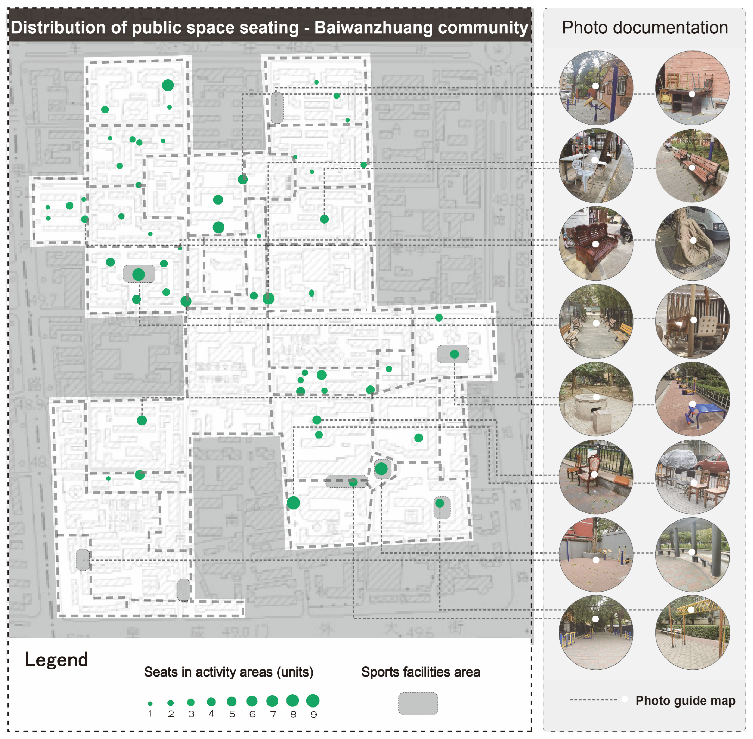
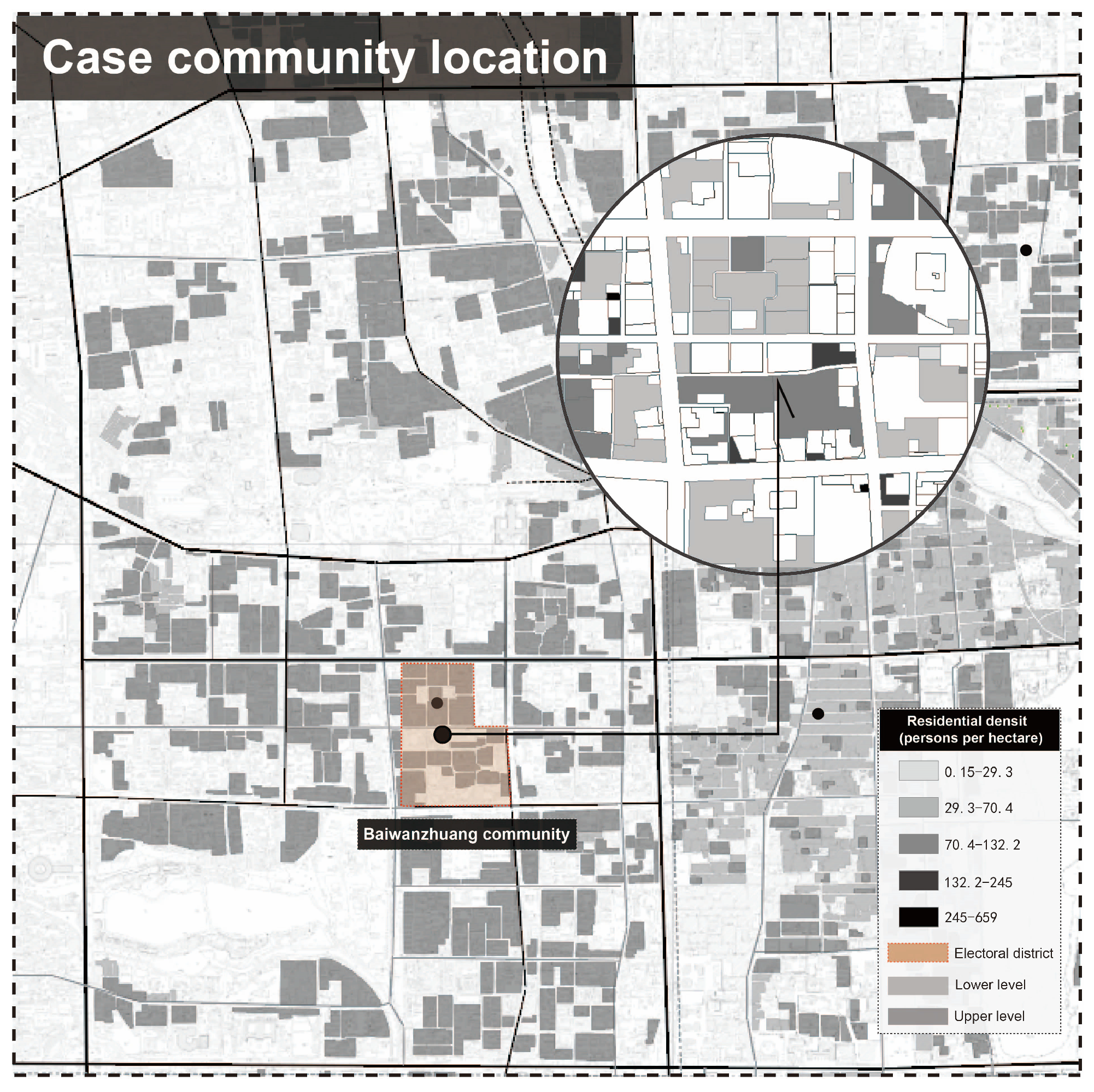
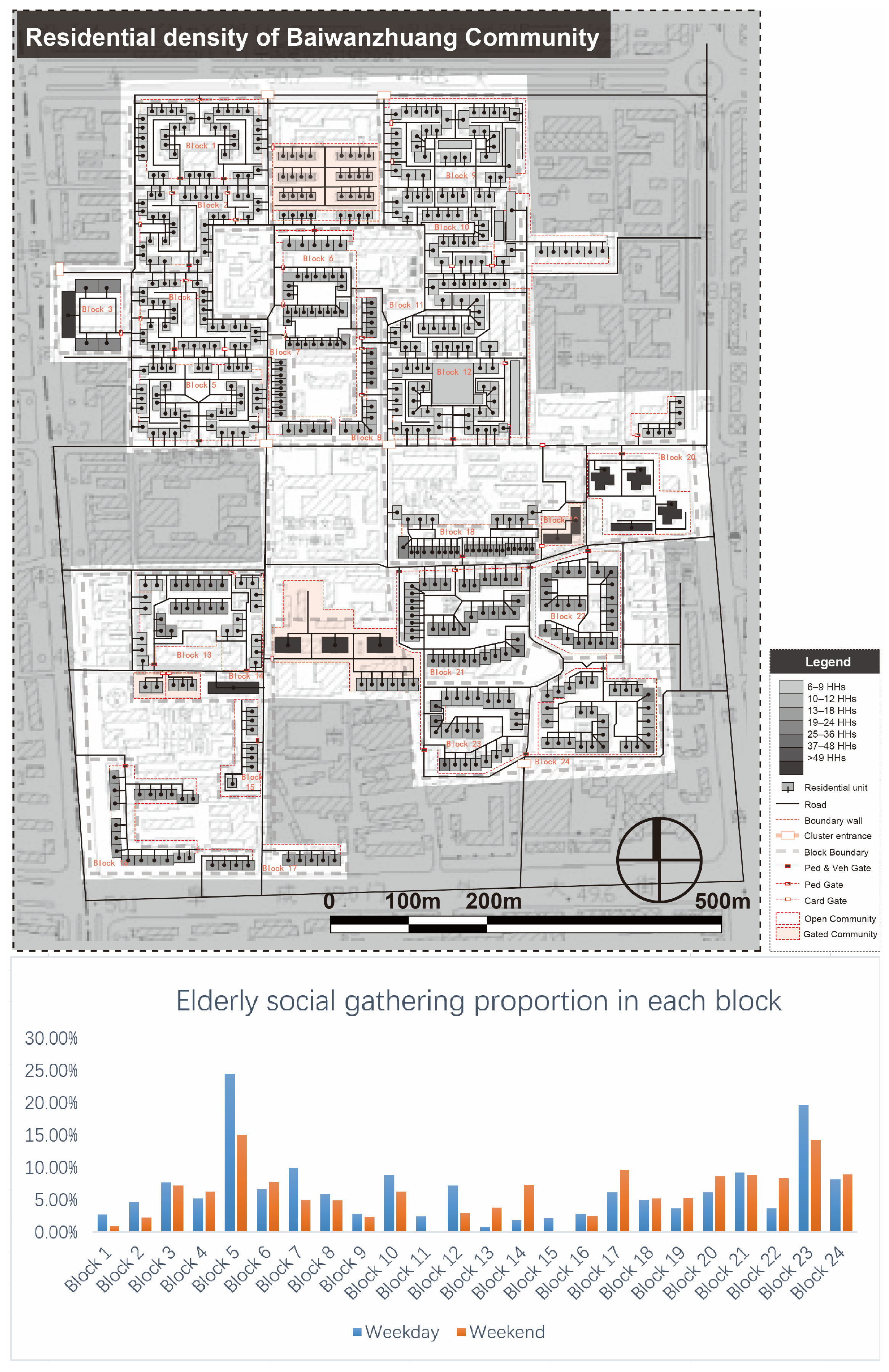
As the first large-scale residential pilot area in New China, Beijing’s Baiwanzhuang community integrates the “neighborhood unit” theory with traditional Chinese courtyard spatial logic, forming a three-tier public space structure: central green space–cluster courtyards–peripheral green strips (
Figure 1). However, after 70 years of transformation, its inherent spatial justice framework has been severely distorted, making it a representative case that embodies the tension between equity and low-carbon goals. On the material level, the three-tier public space system has undergone structural disintegration, with the encroachment of the central green area resulting in a fragmented service network. Socially, a high proportion of elderly residents (53.2%) and a large floating population (41.6%) trigger intergenerational conflicts in spatial needs, causing compliant facilities to fall into an “adaptive dilemma” of quantity compliance but quality failure [
9], ultimately suppressing walking motivation. Spatially, the low plot ratio creates a sense of spatial depression, while surrounding high-rises sever historical pedestrian corridors and produce scale mismatches, jointly hinder low-carbon walking. Governance-wise, fragmented property rights combined with difficulties in property fee collection result in a persistent absence of renewal and maintenance mechanisms. This multi-dimensional spatial injustice not only weakens the social integration function of the community but also severs the path dependence of low-carbon travel for the elderly at the micro-scale, forcing them into non-low-carbon lifestyles. Therefore, analyzing the structural defects of Baiwanzhuang is the key to reconstructing the community’s low-carbon micro-circulation.
2. What Is the Role of Space Syntax in Equitable Accessibility and Low-Carbon Travel?
Spatial justice, as the spatial manifestation of social justice, comprises three interrelated dimensions: distributive equity, procedural justice, and recognitional inclusion [
10]. This study centers on the material dimension—how the physical attributes of public spaces, including distribution, accessibility, and quality, safeguard the spatial rights of vulnerable groups such as the elderly and floating populations [
11], while enabling low-carbon behaviors such as walking. Imbalances in the material dimension often manifest as park poverty (insufficient per capita area) or the paradox of nominal compliance but functional failure [
12,
13,
14,
15]. In urban communities, mismatches between spatial accessibility and functional suitability can further exacerbate carbon emission intensity [
16]. Processes of privatization and commercialization exacerbate spatial exclusivity and deepen social stratification [
17,
18]. Achieving distributive equity in public spaces requires transcending compensatory approaches and establishing a differentiated supply mechanism grounded in equal rights [
19,
20], thereby ensuring both equitable accessibility for low-carbon mobility and the appropriateness of facility provision. Within this framework, the precise diagnosis and optimization of physical spatial structures serve as critical entry points for enhancing both spatial justice and low-carbon effectiveness—underscoring the urgent need for effective quantitative spatial analysis tools.
To address these challenges, this study introduces Space Syntax as a core analytical tool to reconstruct the understanding of walking accessibility from a topological perspective. Addressing the paradox where physical distances are short but walking willingness is low, space syntax uses a segment model to identify “cognitive resistance” in physical space. Hillier et al. point out that human walking perception is not solely based on metric distance but is constrained by line-of-sight turns and path depth. For the environment-sensitive elderly, even if a destination is physically adjacent, if the path lies deep within the micro-topological structure, it constitutes a high-energy travel barrier. Therefore, it is necessary to simulate the elderly’s micro-living circle by setting specific calculation radii to precisely quantify this hidden structural resistance. Space syntax parameters can effectively translate physical justice demands and low-carbon behavior potential into quantifiable spatial structural characteristics. Normalized Angular Integration (NAIN) measures the centrality and accessibility of spatial nodes within a specific geometric radius (Hillier et al. [
21]), diagnosing the equity of pedestrian networks. Normalized Angular Choice (NACH) reflects the through-movement potential and intermediacy of nodes, identifying main road loads. These indicators, when integrated with population and facility data, help uncover mismatches in service provision [
22,
23]. Space syntax follows a “spatial diagnosis-justice regulation” logic; its analysis results can directly guide low-carbon retrofits anchored in spatial structure optimization, such as embedding pocket green spaces to suture discontinuities and enhance walking convenience within the 500 m life circle [
24,
25,
26]. It should be noted that this method has limitations regarding modeling subjectivity and parameter sensitivity, requiring combination with geographic information and field verification for mitigation [
27,
28]. In the Chinese urban context, scholars have extensively studied the correlation between spatial form and outdoor activities. Professor Qiang Sheng and his team have confirmed that spatial accessibility (integration, choice) and greening factors determine the distribution of stationary social activities and green space use efficiency in Beijing’s hutongs and modern parks [
29,
30,
31]. Similarly, while Yufeng Yang has previously tested the “movement economy” theory, revealing how street morphology dominates pedestrian movement in different urban textures [
32,
33], his most recent research crucially extends this perspective to stationary activities. Yang et al. empirically investigated standing, sitting, and social interactions in Chinese housing estates, demonstrating that spatial accessibility is also a decisive driver for these stationary behaviors [
34]. In the Baiwanzhuang case, this study focuses on two application pathways: first, optimizing service equity based on spatial structure diagnosis results to eliminate spatial deprivation in peripheral clusters; second, precisely identifying key driving factors influencing elderly gathering behavior (a proxy for low-carbon walking) based on correlation analysis and multiple regression modeling results between space syntax parameters and variables like facility density and resident population, ultimately synergistically achieving goals of equitable accessibility and low-carbon resilience [
35].
Crucially, the key driving factors identified in this study directly point to the actual demand for community micro-public spaces. Research shows that the precision configuration of micro-public spaces has a significant leverage effect in promoting low-carbon walking behaviors [
36], and the role of green infrastructure in addressing urban climate change and demographic shifts is consistently emphasized [
37]. The multi-scale analysis of space syntax provides a key methodological foundation for precisely analyzing and optimizing the configuration of such micro-spaces, which in turn have a significant leverage effect in activating low-carbon walking behaviors among elderly residents. Therefore, facing the core challenge of synergizing “equity” and “low-carbon” goals in stock renewal, this study employs space syntax technology to quantitatively diagnose community spatial structural defects, providing a scientific tool and implementation paradigm for exploring human-oriented green renewal pathways.
4. Analysis of Spatial Justice Imbalance and Low-Carbon Behavior Impact Mechanism
Based on detailed survey data, this chapter employs macro-scale zonal statistics and micro-scale space syntax models to analyze the usage characteristics of public space in Baiwanzhuang (characterized by elderly social gathering) and their driving factors at different scales. It focuses on revealing the constraining mechanism of spatial structural injustice on low-carbon travel behaviors, providing empirical evidence for the subsequent precision low-carbon reconstruction design.
4.1. Macro Scale: Gathering Spatial Differentiation and Preliminary Exploration of Low-Carbon Behavior
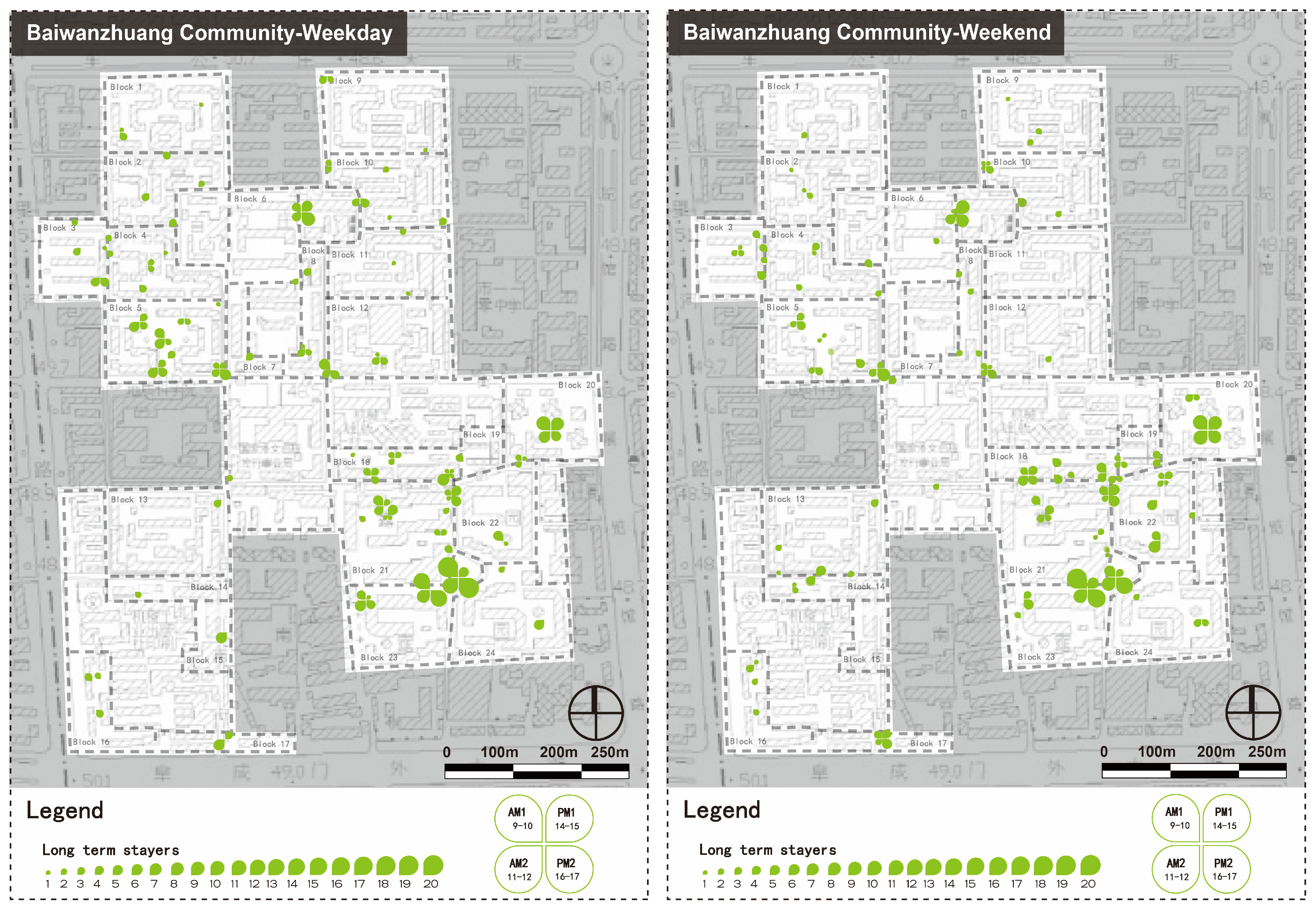
Based on the boundaries of the community’s 24 residential blocks, the proportion of elderly social gathering activities per block was calculated to reveal the relative activity level of gathering and its spatial pattern.
Analysis shows (
Figure 4) that the proportion of elderly gathering exhibits significant spatial differentiation. Blocks 5 and 7 have the highest proportions, primarily benefiting from the attractiveness of abundant public space nodes within the block (e.g., building front open spaces, centralized activity areas, entrance crossroads). The high proportion in Block 6 stems from residents spontaneously utilizing boundary spaces for activities, such as playing mahjong, reflecting adaptive behavior under internal space shortage. In contrast, gathering activity in the southwest (e.g., Units 14, 16) is significantly lower than in the southeast (e.g., Units 21-24), indicating structural fractures in its spatial fabric. Furthermore, Block 23 shows a particularly high gathering proportion, closely related to the good accessibility, suitable scale, and facility configuration of its inter-block activity spaces, effectively promoting residents’ adoption of short-distance walking to participate in gathering.
This short-distance walking mode is a key behavioral manifestation of reducing car dependency and achieving low-carbon community life. The macro-analysis preliminarily indicates that the reasonable layout of specific types of public space nodes is a crucial foundation for encouraging residents to choose low-carbon walking for activity participation. The high gathering proportion and walking tendency in Block 23 provide behavioral evidence for its relatively rational spatial configuration. Conversely, the low gathering areas in the southwest (e.g., Units 14, 16) not only reflect resource scarcity but also imply that residents may be forced to rely on high-carbon travel to reach distant gathering points or reduce outdoor activities due to poor accessibility, directly illustrating how spatial deprivation suppresses low-carbon travel willingness and capacity, exacerbating “walking desertification.” This directs the subsequent micro-scale analysis towards in-depth dissection of spatial structural defects and their impact mechanisms on low-carbon behaviors.
4.2. Micro Scale: Space Syntax Regression Model and Driving Factor Analysis
To precisely identify key spatial and non-spatial factors influencing elderly gathering behavior, this study constructed a space syntax segment model to calculate key spatial variables (e.g., NAIN, NACH). These were combined with surveyed seating numbers and resident population data for correlation analysis and multiple linear regression modeling.
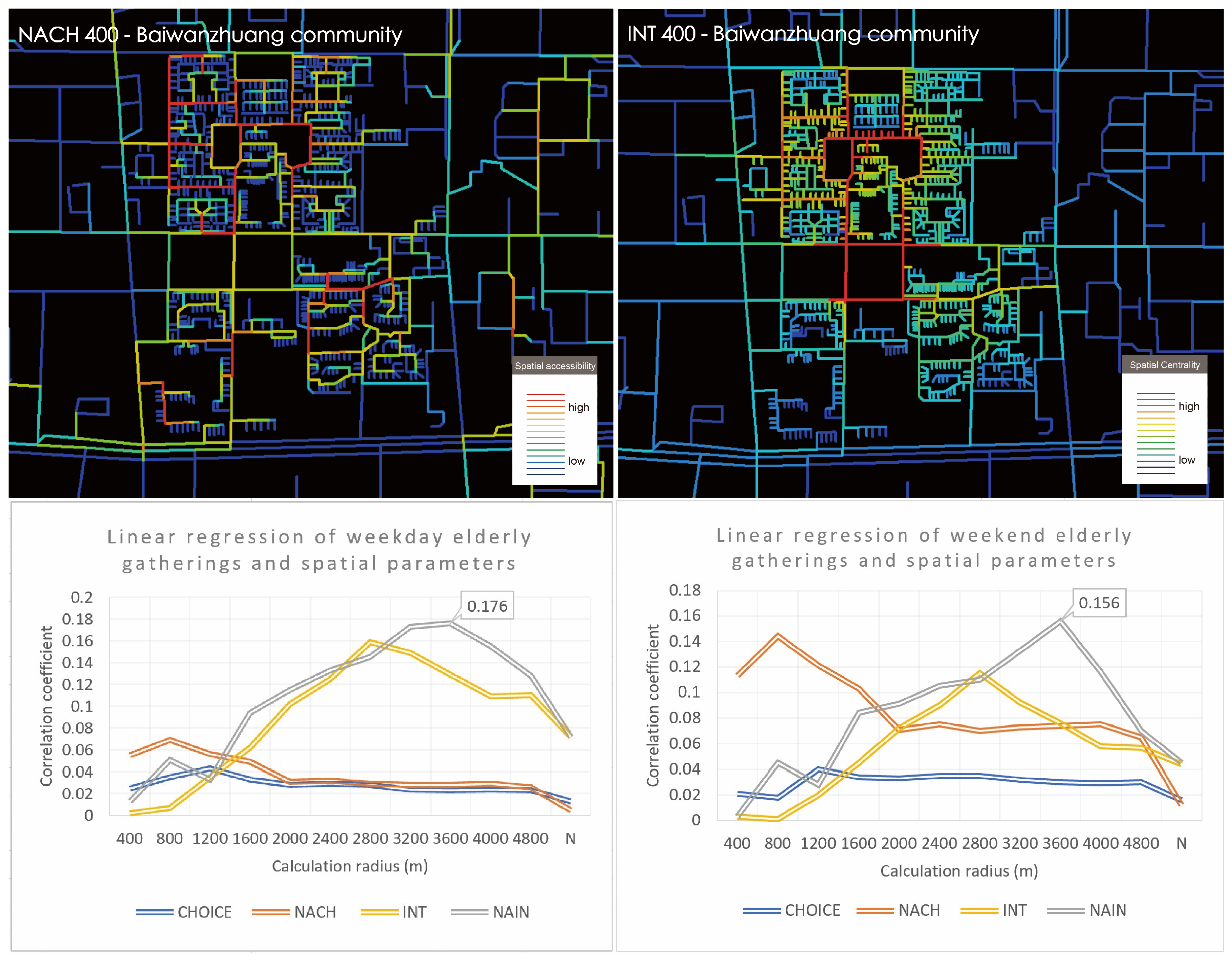
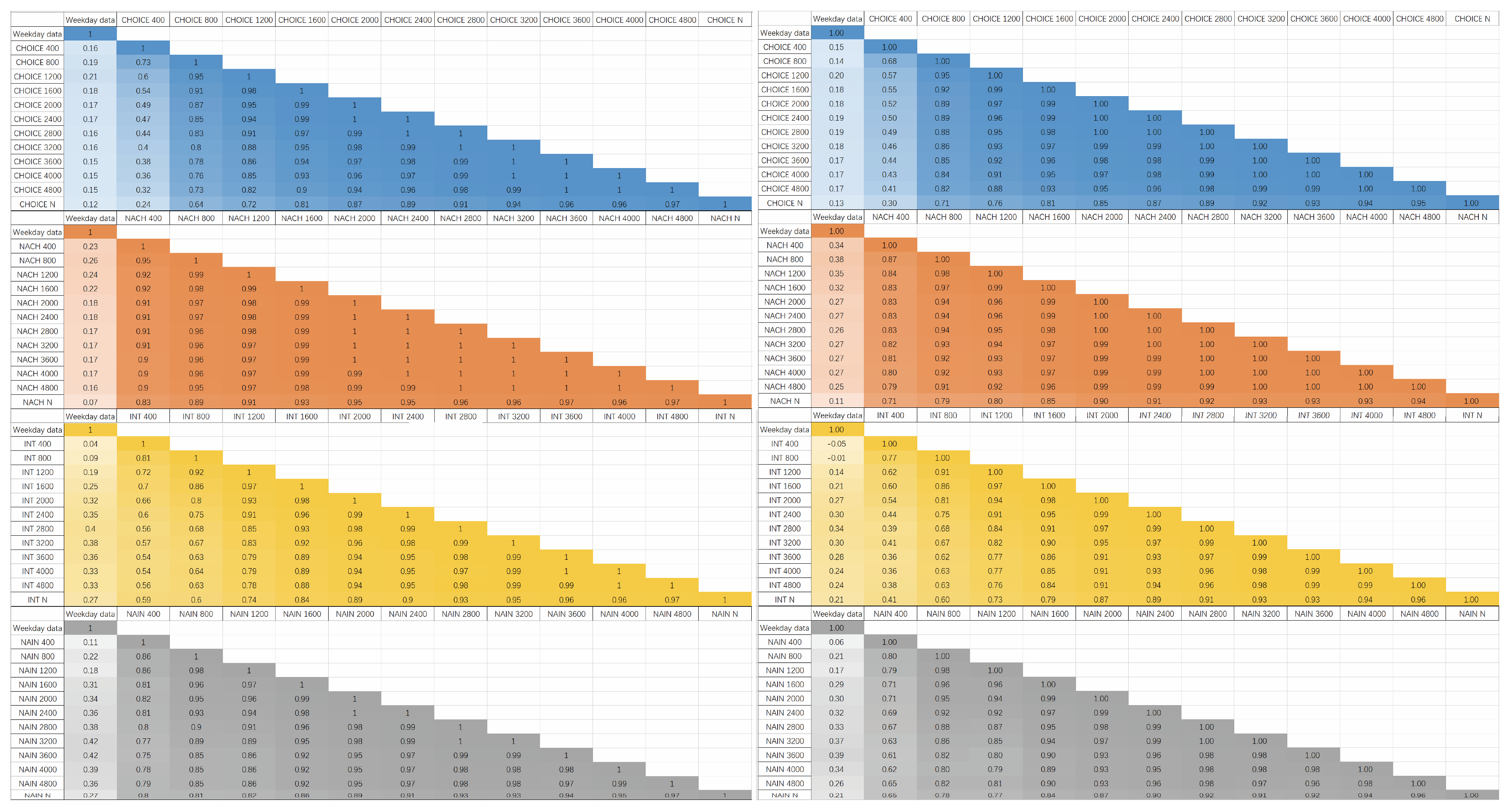
First, univariate correlation analysis results (
Figure 5) show that overall, elderly gathering activities generally exhibit positive correlations with NAIN at different radii. Weekday correlation coefficients (R) range from 0.11 to 0.36, and weekends from 0.06 to 0.26. Correlations with NACH are lower and mostly negative, with weekday correlation coefficients (R) ranging from 0.23 to 0.16 and weekend values from 0.34 to 0.25. Notably, the more pronounced negative correlation with small-scale NACH indicates that disturbances like noise and safety hazards generated by through-movement roads (high NACH values) significantly inhibit stationary gathering activities, highlighting the importance of small-scale, quiet, and safe walking environments for the elderly. Simultaneously, the stronger positive correlation with larger-scale NAIN suggests that the overall high accessibility of the community spatial network is fundamental to reducing resistance for residents to reach public space nodes and encouraging walking. Univariate space syntax regression (
Figure 6) further indicates that NAIN at a 3600 m radius has the strongest explanatory power for gathering quantity (R
2 = 0.18 on weekdays, R
2 = 0.16 on weekends), confirming the foundational influence of community-level large-scale spatial accessibility on the spatial distribution pattern of the elderly.
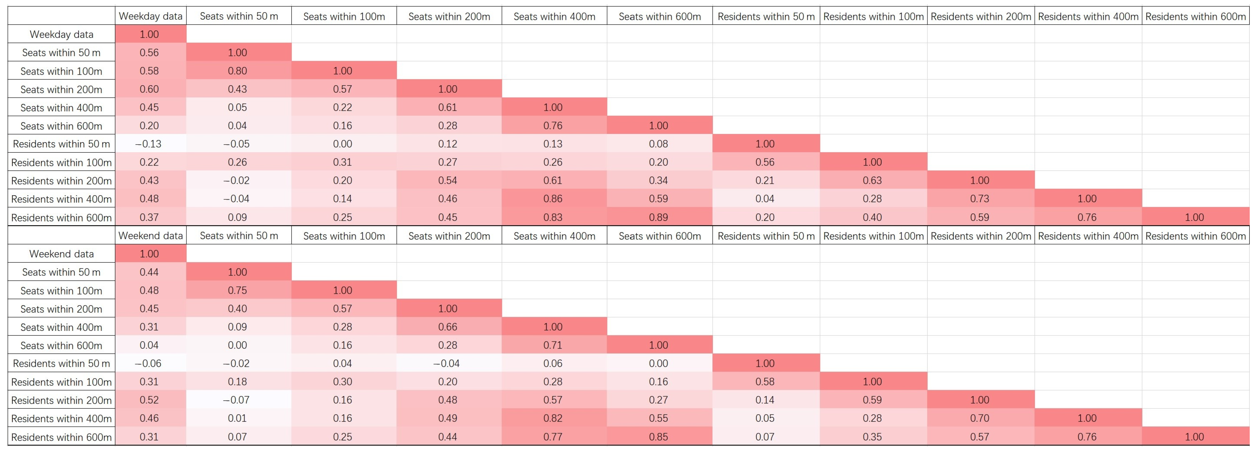
Beyond the spatial analysis of elderly social gathering, non-spatial variables—public seat quantity and resident population—were introduced for multivariate correlation analysis (
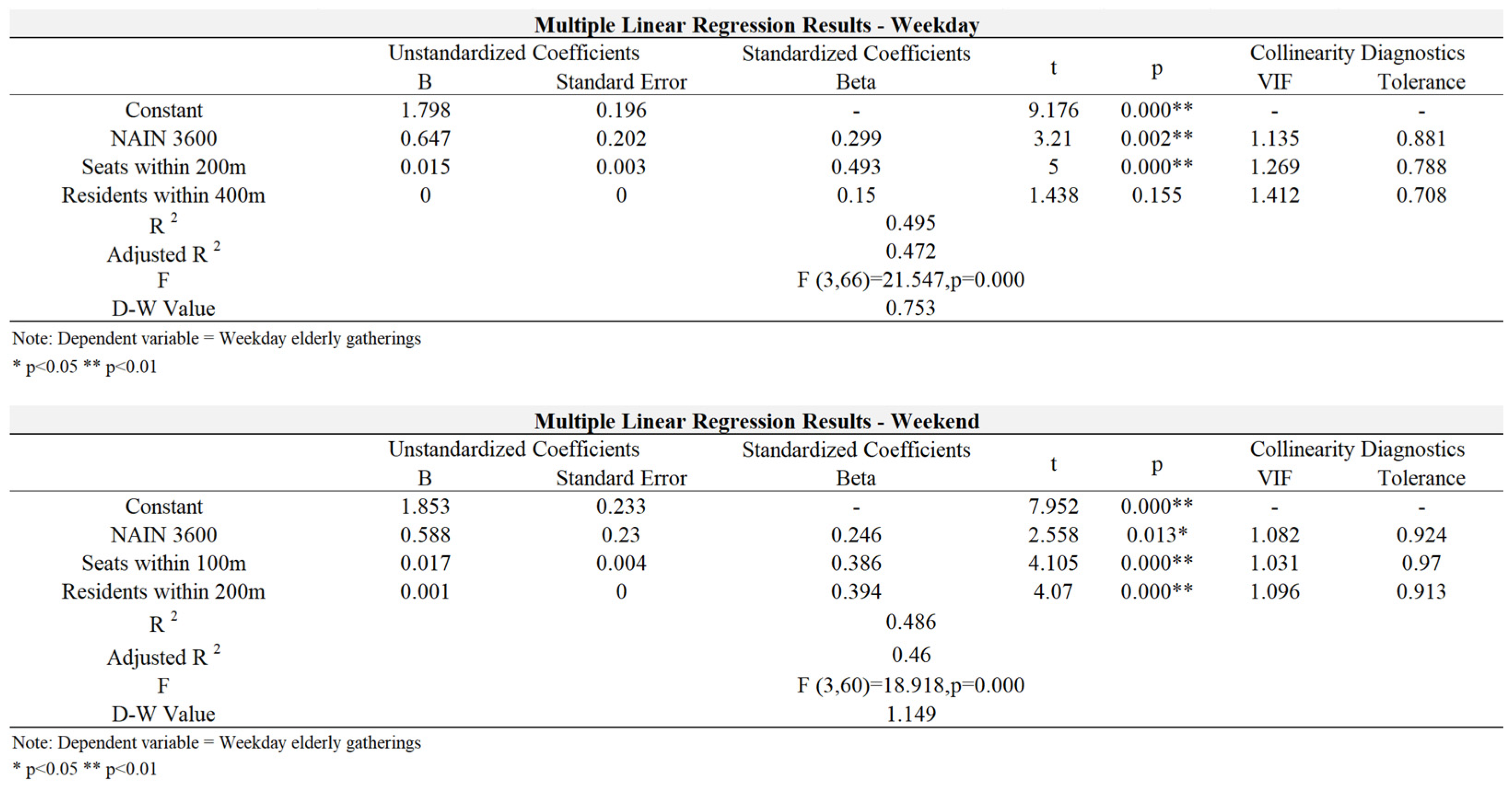
Figure 7). Results show a significant correlation between seat quantity and gathering activity, with weekday values reaching R = 0.60 at a 200 m radius and weekend values R = 0.48 at a 100 m radius. Residential density exhibits a comparatively weaker correlation, showing R = 0.48 at a 400 m radius on weekdays and R = 0.52 at a 200 m radius on weekends, highlighting the attractiveness advantage of public space facility configuration. Building on this, to comprehensively analyze the effects of multiple factors, multiple linear regression models were constructed (
Figure 8).
The weekday model predicting elderly gathering numbers shows good fit (R
2 = 0.50). The regression equation is established as follows:
The model is globally significant (F = 21.547, p < 0.001). Within the model, large-scale spatial integration NAIN 3600 m has a standardized regression coefficient β = 0.647 (t = 3.210, p = 0.002), and small-scale seat count within 200 m has β = 0.015 (t = 5.000, p < 0.001), both showing significant positive effects. The influence of resident population within a 400 m radius is insignificant (β ≈ 0.000, t = 1.438, p = 0.155). These results indicate that weekday elderly gathering behavior is primarily influenced by community-level spatial accessibility (NAIN 3600 m) and close-proximity (200 m) resting facility density, with low immediate dependence on residential density, reflecting the path-dependent nature of elderly daily activities and their demand for facility convenience.
The weekend gathering count prediction model also has good fit (R
2 = 0.49). The regression equation is:
The model is globally significant (F = 18.918, p < 0.001), and all independent variables are statistically significant: large-scale spatial integration (NAIN 3600 m) (β = 0.588, t = 2.558, p = 0.013), small-radius seat count (100 m) (β = 0.017, t = 4.105, p < 0.001), and resident population within 200 m radius (β = 0.001, t = 4.070, p < 0.001) all have significant positive effects. These results indicate that weekend gathering is also primarily dominated by community-level large-scale spatial accessibility and close-proximity resting facility density. Notably, resident population at a smaller scale (200 m) shows an independent promoting effect, possibly related to increased family visits and more frequent collective leisure activities on weekends. It is worth noting that the explanatory radius for seating facilities is smaller on weekends than on weekdays. This does not imply that the elderly prefer longer trips on weekdays, but rather reflects a spatiotemporal shift in behavioral patterns: on weekdays, the elderly have high autonomy and tend to seek specific social circles within the community neighborhood range; on weekends, influenced by activities such as family reunions and childcare, their activity circles shrink to the “doorstep” area, making them more sensitive to the nearest facilities and demonstrating stronger proximity.
4.3. Low-Carbon Behavior Mechanisms Revealed by Statistical Results and Planning Implications
The core finding of this study and its implications for low-carbon design lie in revealing the existence of stable “dual-core driving factors” for elderly gathering (a form of low-carbon travel behavior): larger-scale spatial integration (NAIN 3600 m) and small-radius seating facilities. The significant changes in statistical data reveal the synergistic mechanism between the two: the model’s explanatory power jumps from R2 = 0.18 for the univariate model (space only) to R2 = 0.50 for the multivariate model. This indicates that while pure spatial accessibility can reduce travel resistance, facilities must be superimposed as catalysts to effectively induce staying behavior. The analysis further points out that the contribution of spatial accessibility (NAIN) is significantly higher than that of seating facilities; in the weekday model, their standardized regression coefficient β values differ by 43 times, and by 34 times on weekends. This disparity quantifies the priority of renewal strategies: optimizing the macro-spatial network has high leverage and is the foundation for improving spatial equity, whereas facility density has a weaker effect and requires ultra-high-density deployment to match the foundational role of accessibility.
Therefore, in community renewal with limited resources, priority should be given to optimizing the overall community spatial network structure (such as community centers and group cores) as a foundational strategy to leverage low-carbon walking potential. As a core attractiveness factor, seating facility configuration needs precise anchoring within the short-radius life circle (100–200 m), particularly at existing gathering points, high-potential areas with good accessibility but insufficient facilities, and along main elderly activity paths, to maximize their effectiveness in promoting staying, social interaction, and reducing travel fatigue. The study also observed that the role of resident population exhibits diurnal and scale heterogeneity, showing a significant independent promoting effect only at small scales (200 m) on weekends. This requires low-carbon design to consider the dynamic differences in population activity patterns across time periods, allowing for moderately enhanced weekend elasticity in facility configuration. Ideal low-carbon design ultimately requires synergistic enhancement of medium-to-large scale spatial accessibility (e.g., community-level as reflected by NAIN 3600 m) and small-scale (100–200 m radius) facility density and quality, jointly constructing a “low-resistance accessibility + high-attractiveness node” system. This effectively guides residents, especially the elderly, to choose walking over motorized travel for community activities, thereby reducing community life carbon emissions.
6. Discussion and Conclusions
Framed by spatial justice theory and coupled with space syntax technology, this study deeply analyzed the structural dilemmas and optimization pathways for the low-carbon transformation of public space in Beijing’s Baiwanzhuang community. The main conclusions are as follows.
First, it revealed that the core contradiction in synergizing “equity” and “low-carbon” goals for community public spaces in the stock context lies in the superimposition of accessibility justice deficits and facility suitability failure. Space syntax analysis (NAIN metric) empirically demonstrated the community’s “core enrichment-periphery deprivation” polarization pattern and “walking desertification” caused by fractured spatial integration, severely constraining the low-carbon travel potential of its high-aging population. Simultaneously, facilities are trapped in the paradox of “quantity compliance, quality failure,” unable to effectively support daily needs and low-carbon behaviors. This structural injustice in the physical space appears to be a major factor contributing to the weakened social integration function of public spaces and the hindered release of low-carbon efficacy.
Second, it quantitatively verified the core interaction mechanism between spatial form and social low-carbon behavior. The study found that community-level spatial accessibility, which is characterized by large-scale NAIN 3600 m, serves as the foundational priority factor facilitating elderly gathering (a proxy for low-carbon walking behavior). Its explanatory power and contribution significantly surpass those of close-proximity resting facility density. This strongly indicates that in resource-constrained renewal, optimizing the overall spatial network structure and enhancing the accessibility of key nodes is a more leveraged foundational strategy for improving spatial equity and unlocking low-carbon potential. Although the contribution of driving factors differs between weekdays and weekends, spatial accessibility consistently remains the dominant core factor, confirming its foundational role. Concurrently, facility configuration needs precise anchoring within the short-radius (100–200 m) life circle to maximize its attractiveness effect. The study successfully applied space syntax combined with empirical data, providing an effective quantitative tool for diagnosing the material dimension of spatial justice and its association with low-carbon behaviors.
Third, it constructed an integrated framework for synergistic “spatial justice-low-carbon efficacy” reconstruction, namely the three-dimensional synergistic paradigm of “spatial repair priority, facility precision suitability, institutional empowerment guarantee.” Spatially, based on syntax diagnosis, implant pocket green spaces and vertical connection systems to suture fracture zones, optimize network structure, and enhance peripheral accessibility and inclusivity. Facility-wise, grounded in the empirical “seating effect,” densify the layout of integrated, age-friendly low-carbon facilities like “Street Living Rooms” in high-potential short-radius zones. Governance-wise, innovatively establish a renewal committee with vulnerable group participation, formulate a property-incorporated low-carbon convention and patrol mechanism, and set up a special fund, building a sustainable governance framework. This paradigm aims to systematically eliminate spatial deprivation, simultaneously enhancing spatial equity, inclusive accessibility, facility suitability, and institutional sustainability, ultimately unleashing the low-carbon efficacy and social integration value of public spaces.
In summary, this study not only provides a renewal scheme for the Baiwanzhuang Community that integrates equity, inclusiveness, and low-carbon resilience, but also clarifies core contributions at both theoretical and practical levels. Theoretically, this study fills the gap in quantitative evaluation tools for the material dimension of spatial justice and reveals the low-carbon mechanism of “exchanging space for travel”. Specifically, it confirms that a high-quality micro-scale walking network can effectively “intercept” the social needs of older adults within the community, thereby substituting the motor vehicle dependency (hidden carbon emissions) forced by spatial scarcity. This establishes the logical correlation that repairing spatial justice achieves “source carbon reduction”. Practically, this study advances spatial justice theory from macroscopic critique to the level of microscopic intervention, constructing a replicable synergistic renewal paradigm of “structural optimization–precise supply–institutional innovation”. This provides an innovative path shifting from technological stacking to spatial governance for a vast number of old communities nationwide facing similar challenges, holding significant reference value for promoting human-oriented urban green renewal and sustainable community construction.
Despite these contributions, this study has certain limitations that need to be addressed in future work. First, regarding sample selection, this study relies solely on Beijing Baiwanzhuang—a typical “neighborhood unit” system old community—as the empirical case. Community spatial patterns may differ across various construction eras or climatic zones; thus, the generalizability of the conclusions requires verification through multiple samples. Second, regarding spatiotemporal observation coverage, constrained by survey conditions, data collection was concentrated in autumn and concluded at 17:00 daily. This exclusion of summer evenings—an important period for outdoor activities among the elderly—may lead to the omission of certain behavioral characteristics. Finally, this study primarily uses “social gathering” as a proxy variable for low-carbon walking and did not directly quantify specific carbon emission reduction values or establish a strict causal link between spatial forms and emission metrics. Future research should introduce GPS all-weather tracking technology and carbon metering models to obtain more comprehensive full-time behavioral data and to precisely calculate the actual carbon reduction benefits after spatial micro-renewal, thereby perfecting the quantitative evaluation system for low-carbon community renewal.