The Spatiotemporal Evolution Characteristics and Influencing Factors of Traditional Villages in the Qinling-Daba Mountains

Abstract
1. Introduction
- The spatial expansion of the study area to the full physiographic extent of the Qinling-Daba Mountains permits the systematic interrogation of traditional villages beyond administrative confines and across heterogeneous landscapes.
- By synthesizing village formation chronologies (Pre-Qin to Qing Dynasty) with documented fluvial–geomorphic adjustments, trade route realignments, and urban morphological transitions, this research traces diachronic policy impacts to elucidate the multidimensional influences of geo-environmental constraints, socio-cultural dynamics, and institutional frameworks on settlement evolution.
- Core driving factors were selected to construct a classification framework, use the Geodetector model to quantify the spatiotemporal differentiation dynamics of traditional villages and their nonlinear synergies, and integrate village formation timelines with historical changes in fluvial–geomorphic features. Interaction quantification decoded nonlinear synergies among natural, cultural, and policy drivers.
2. Materials and Methods
2.1. Study Object
2.2. Data Collection
2.3. Research Tools and Methods
2.3.1. Average Nearest Neighbor
2.3.2. Standard Deviational Ellipse
2.3.3. Kernel Density
2.3.4. Geographical Detector
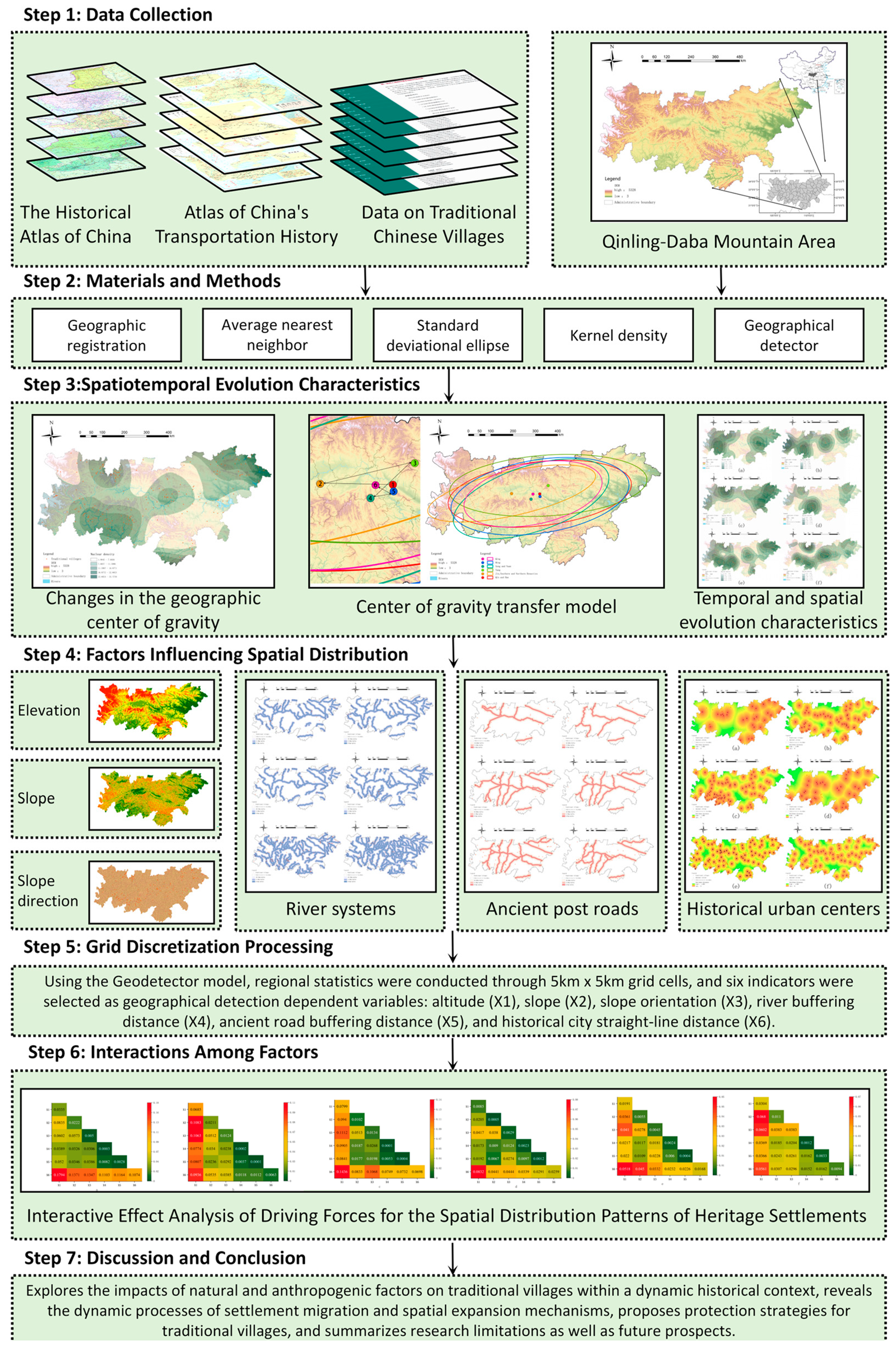
3. Results
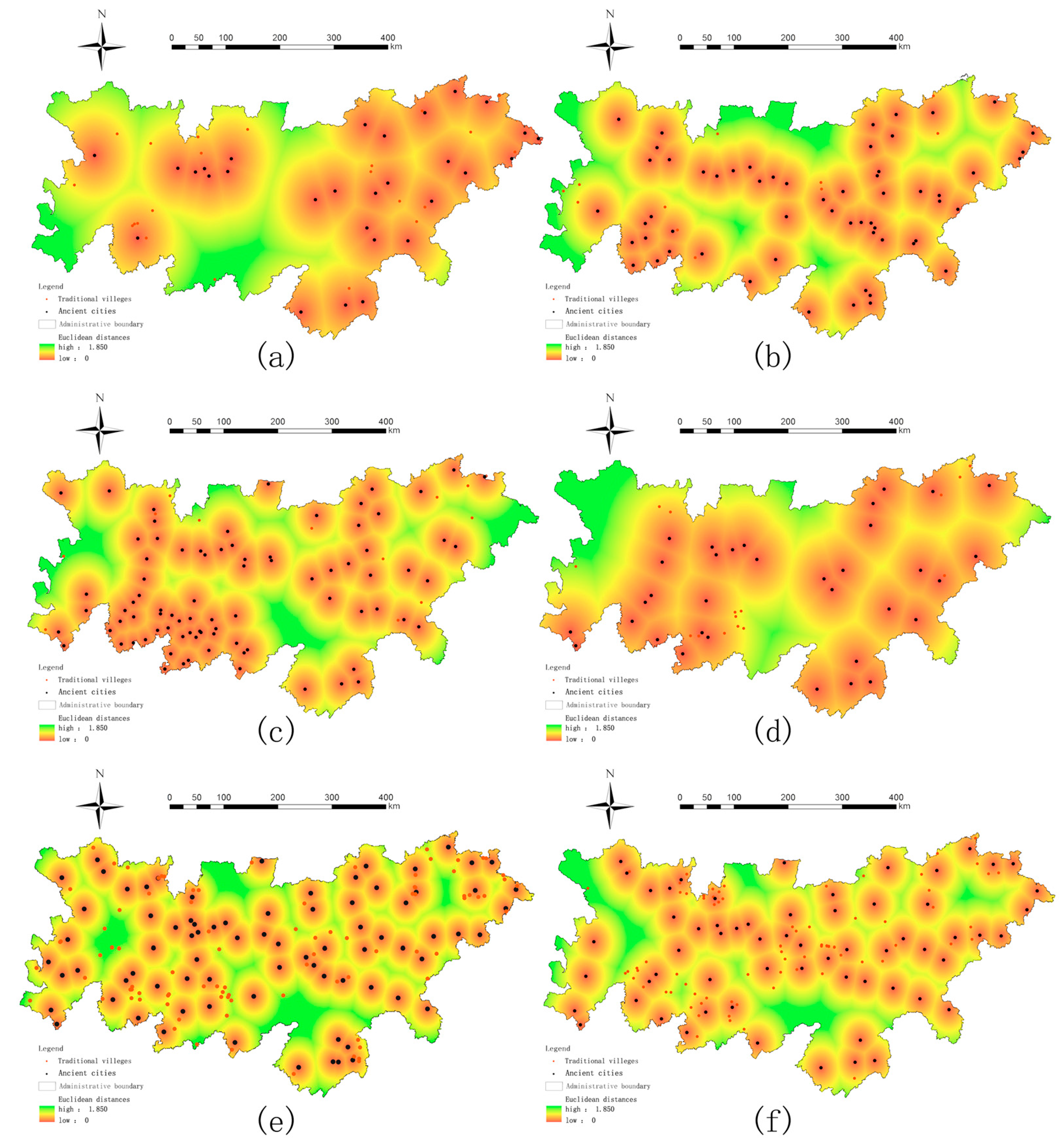
3.1. Spatial Distribution Pattern
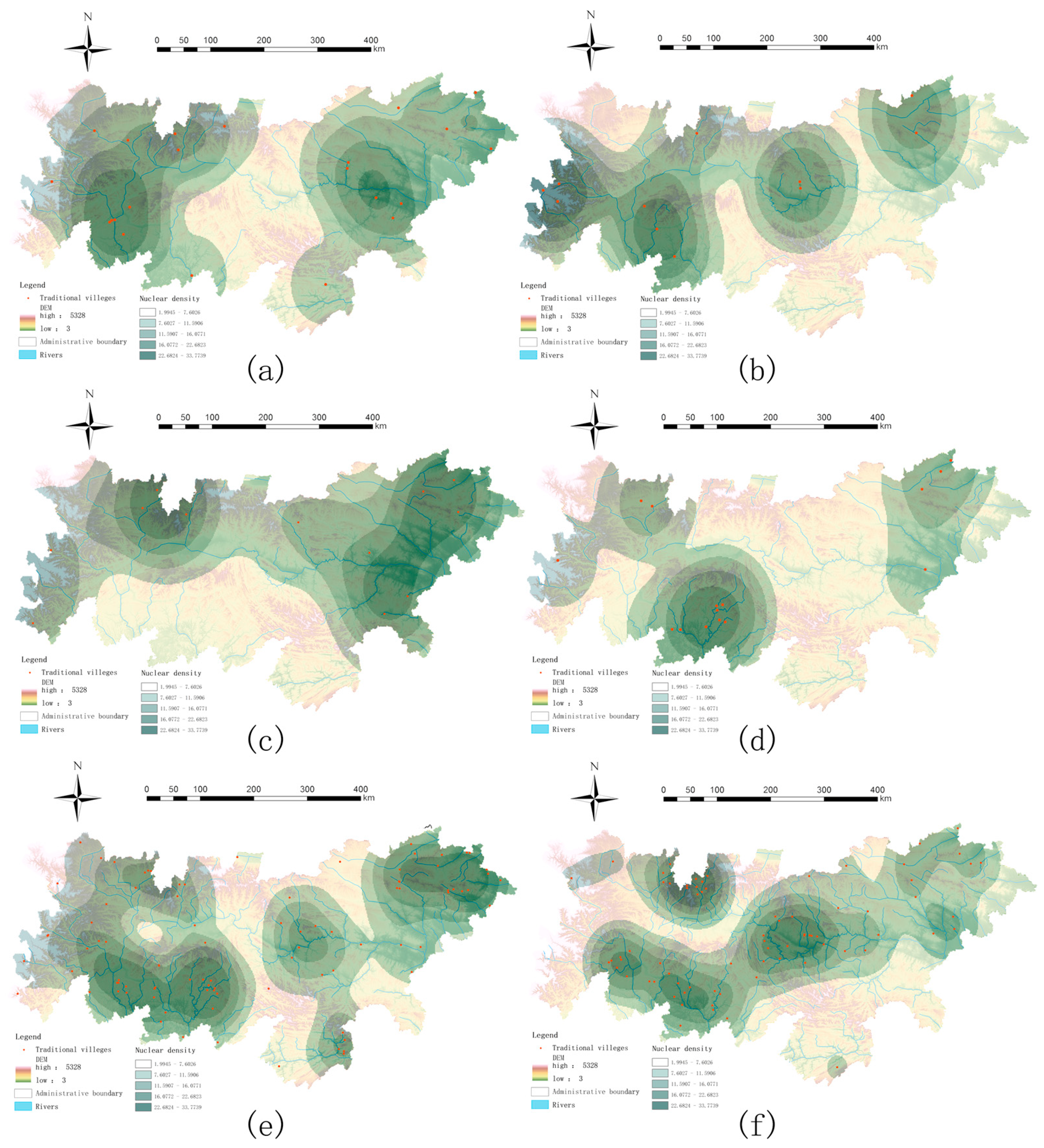
3.2. Spatial Distribution Density
3.3. Changes in the Geographic Center of Gravity
3.4. Temporal and Spatial Evolution Characteristics
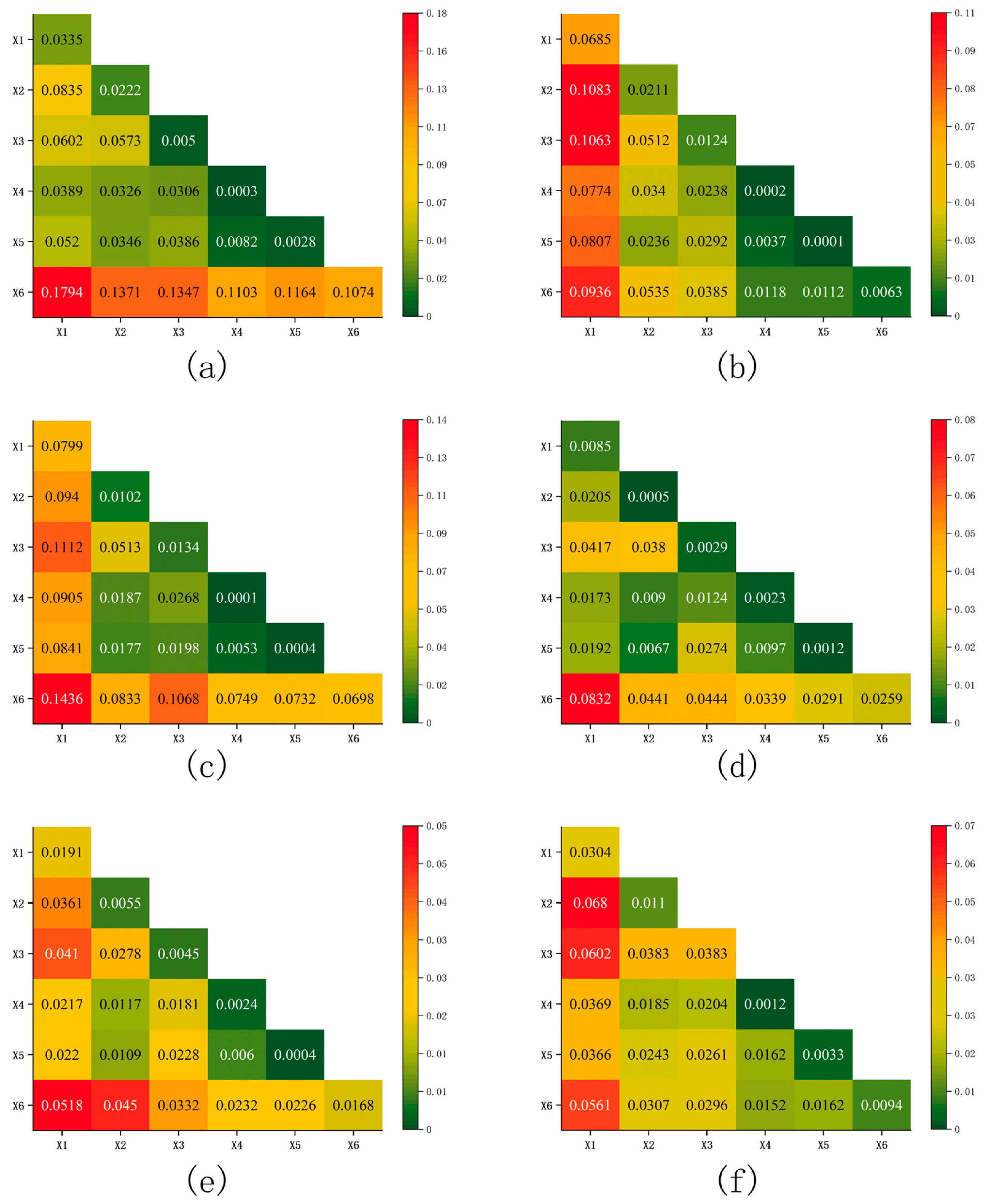
3.5. Factors Influencing Spatial Distribution
3.6. Interactions Among Factors
4. Discussion
5. Conclusions
- The villages exhibit a distinct mononuclear clustering pattern coexisting with multi-regional symbiosis. The evolutionary process, from the nascent Qin–Han stage to the mature Ming–Qing phase, suggests a southwestward shift in spatial centroids, primarily along hydrological and transportation corridors. This trajectory indicates millennia-long adaptive human–environment interactions.
- The q-statistic analysis reveals a significant shift in drivers: early settlement patterns were strongly coupled with natural infrastructure (q > 0.07), while later stages transitioned to human-dominated adaptation (q ≤ 0.05). During this transition, socio-political agency, manifested through agrotechnologies (e.g., terraces and drought-resistant crops) and policies (e.g., military colonies and migration initiatives), effectively overcame environmental constraints. Settlement concentration favored sunny slopes proximal to waterways (76% within 1 km), with key anthropogenic catalysts (e.g., ‘Huguang-filling-Sichuan’ migration, tea–horse trade, and Qing agricultural innovations) driving the southwestward shift. This finding quantitatively demonstrates how transitional mountainous zones reconcile environmental limitations with socio-political agency through synergistic natural-foundation and cultural-economic networks.
- Conservation strategies should prioritize the integrity of historic socio-ecological networks, such as the Han River Valley’s water-transport-settlement systems. Reactivating cultural corridors (e.g., the Micang Route) could be enhanced by digital twin technology, building on China’s “14th Five-Year Plan” initiatives for cultural heritage digitalization. Integrating traditional ecological knowledge (e.g., terrace hydrology) with modern agroecology aligns with pilot projects like the Qinling Ecological Compensation Mechanism Pilot, which could inform the establishment of ecological compensation funds.
Author Contributions
Funding
Data Availability Statement
Acknowledgments
Conflicts of Interest
References
- Wang, H.; Chiou, S. Study on the Sustainable Development of Human Settlement Space Environment in Traditional Villages. Sustainability 2019, 11, 4186. [Google Scholar] [CrossRef]
- Hu, X.; Li, H.; Zhang, X.; Chen, X.; Yuan, Y. Multi-dimensionality and the totality of rural spatial restructuring from the perspective of the rural space system: A case study of traditional villages in the ancient Huizhou region, China. Habitat. Int. 2019, 94, 102062. [Google Scholar] [CrossRef]
- Wu, C.; Chen, M.; Zhou, L.; Liang, X.; Wang, W. Identifying the Spatiotemporal Patterns of Traditional Villages in China: A Multiscale Perspective. Land 2020, 9, 449. [Google Scholar] [CrossRef]
- Zhou, M.; Chu, S.; Du, X. Safeguarding traditional villages in China: The role and challenges of Rural Heritage preservation. Built Herit. 2019, 3, 81–93. [Google Scholar] [CrossRef]
- Körl, J.G. Die Beziehungen Zwischen den Menschenverrichtungen, dem Wohnsitze und der Topographie; Justus Perthes: Gotha, Germany, 1841. [Google Scholar]
- Schultze, O. Bemerkungen zur Siedlungsgeographie; B.G. Teubner: Leipzig, Germany, 1906. [Google Scholar]
- National Traditional Village List. Available online: http://www.chuantongcunluo.com/index.php/Home/Gjml/gjml/id/24.html (accessed on 5 June 2025).
- Ma, H.; Tong, Y. Spatial differentiation of traditional villages using ArcGIS and GeoDa: A case study of Southwest China. Ecol. Inform. 2022, 68, 101416. [Google Scholar] [CrossRef]
- Zhang, Y.; Han, N.; Zhang, B.; Lu, C.; Yang, M.; Zhai, F.; Li, H. Spatial and temporal distribution characteristics and evolution of traditional villages in the Qihe River Basin of China. Sci. Rep. 2025, 15, 10077. [Google Scholar] [CrossRef]
- Nie, Z.; Chen, C.; Pan, W.; Dong, T. Exploring the Dynamic Cultural Driving Factors Underlying the Regional Spatial Pattern of Chinese Traditional Villages. Buildings 2023, 13, 3068. [Google Scholar] [CrossRef]
- Deng, Y.; Zhou, W.; Fu, X.; Yao, Y. Analysis of the evolutionary process of traditional village spatial pattern: The case of Gaoyi village in Western Hunan, China. PLoS ONE 2024, 19, e0309814. [Google Scholar] [CrossRef]
- Qin, R.J.; Leung, H.H. Becoming a Traditional Village: Heritage Protection and Livelihood Transformation of a Chinese Village. Sustainability 2021, 13, 2331. [Google Scholar] [CrossRef]
- Wang, L.; Wen, C. Traditional Villages in Forest Areas: Exploring the Spatiotemporal Dynamics of Land Use and Landscape Patterns in Enshi Prefecture, China. Forests 2021, 12, 65. [Google Scholar] [CrossRef]
- Zhou, Y.; Liu, M.; Xie, G.; Liu, C. Landscape Ecology Analysis of Traditional Villages: A Case Study of Ganjiang River Basin. Appl. Sci. 2024, 14, 929. [Google Scholar] [CrossRef]
- Liu, P.; Zeng, C.; Liu, R. Environmental adaptation of traditional Chinese settlement patterns and its landscape gene mapping. Habitat. Int. 2023, 135, 102808. [Google Scholar] [CrossRef]
- Lin, Z.; Chen, K.; Jiao, K.; Li, Z. Spatio-temporal characteristics of traditional village landscape pattern and its influencing factors from the perspective of tourism development: A case study of Huangcheng Village, China. J. Asian Archit. Build. Eng. 2025, 24, 1000–1012. [Google Scholar] [CrossRef]
- Fang, Q.; Li, Z. Cultural ecology cognition and heritage value of huizhou traditional villages. Heliyon 2022, 8, e12627. [Google Scholar] [CrossRef]
- Xu, Q.; Wang, J. Recognition of Values of Traditional Villages in Southwest China for Sustainable Development: A Case Study of Liufang Village. Sustainability 2021, 13, 7569. [Google Scholar] [CrossRef]
- Katapidi, I. Heritage policy meets community praxis: Widening conservation approaches in the traditional villages of central Greece. J. Rural Stud. 2021, 81, 47–58. [Google Scholar] [CrossRef]
- Shen, J.; Chou, R.J. Rural revitalization of Xiamei: The development experiences of integrating tea tourism with ancient village preservation. J. Rural Stud. 2022, 90, 42–52. [Google Scholar] [CrossRef]
- Zhou, Z.; Zheng, X. A Cultural Route Perspective on Rural Revitalization of Traditional Villages: A Case Study from Chishui, China. Sustainability 2022, 14, 2468. [Google Scholar] [CrossRef]
- Tang, C.; Liu, Y.; Wan, Z.; Liang, W. Evaluation system and influencing paths for the integration of culture and tourism in traditional villages. J. Geogr. Sci. 2023, 33, 2489–2510. [Google Scholar] [CrossRef]
- Bian, J.; Chen, W.; Zeng, J. Spatial Distribution Characteristics and Influencing Factors of Traditional Villages in China. Int. J. Environ. Res. Public Health 2022, 19, 4627. [Google Scholar] [CrossRef]
- Chen, Y.; Li, R. Spatial Distribution and Type Division of Traditional Villages in Zhejiang Province. Sustainability 2024, 16, 5262. [Google Scholar] [CrossRef]
- Liu, W.; Xue, Y.; Shang, C. Spatial distribution analysis and driving factors of traditional villages in Henan province: A comprehensive approach via geospatial techniques and statistical models. Herit. Sci. 2023, 11, 185. [Google Scholar] [CrossRef]
- Zheng, X.; Wu, J.; Deng, H. Spatial distribution and land use of traditional villages in southwest China. Sustainability 2021, 13, 6326. [Google Scholar] [CrossRef]
- Zhu, Q.; Liu, S. Spatial morphological characteristics and evolution of traditional villages in the mountainous area of Southwest Zhejiang. Isprs Int. J. Geo-Inf. 2023, 12, 317. [Google Scholar] [CrossRef]
- Chen, W.; Yang, L.; Wu, J.; Wu, J.; Wang, G.; Bian, J.; Liu, Z. Spatio-temporal characteristics and influencing factors of traditional villages in the Yangtze River Basin: A Geodetector model. Herit. Sci. 2023, 11, 111. [Google Scholar] [CrossRef]
- Li, T.; Li, C.; Zhang, R.; Cong, Z.; Mao, Y. Spatial heterogeneity and influence factors of traditional villages in the Wuling Mountain area, Hunan Province, China based on Multiscale Geographically Weighted Regression. Buildings 2023, 13, 294. [Google Scholar] [CrossRef]
- Gao, C.; Wu, Y.; Bian, C.; Gao, X. Spatial characteristics and influencing factors of Chinese traditional villages in eight provinces the Yellow River flows through. River Res. Appl. 2023, 39, 1255–1269. [Google Scholar] [CrossRef]
- Yan, Y.; Jing, H.; Dajun, L.; Yaoyan, J.I.A. Spatial structure identification and influence mechanism of Miao traditional villages in Guizhou Province. Econ. Geogr. 2021, 41, 232–240. [Google Scholar] [CrossRef]
- Xie, G.; Zhou, Y.; Liu, C. Spatial distribution characteristics and influencing factors of Hakka traditional villages in Fujian, Guangdong, and Jiangxi, China. Sustainability 2022, 14, 12068. [Google Scholar] [CrossRef]
- Jin, L.; Wang, Z.; Chen, X. Spatial distribution characteristics and influencing factors of traditional villages on the Tibetan Plateau in China. Int. J. Environ. Res. Public Health 2022, 19, 13170. [Google Scholar] [CrossRef]
- Xu, Y.; Yang, X.; Feng, X.; Yan, P.; Shen, Y.; Li, X. Spatial distribution and site selection adaptation mechanism of traditional villages along the Yellow River in Shanxi and Shaanxi. River Res. Appl. 2023, 39, 1270–1282. [Google Scholar] [CrossRef]
- Zhu, J.; Xu, W.; Xiao, Y.; Shi, J.; Hu, X.; Yan, B. Temporal and spatial patterns of traditional village distribution evolution in Xiangxi, China: Identifying multidimensional influential factors and conservation significance. Herit. Sci. 2023, 11, 261. [Google Scholar] [CrossRef]
- Gao, S.; Wang, J.; Liu, S.; Xu, X.; Liao, Y.; Zhang, Z.; Sun, T. Spatio-temporal evolution characteristics and influencing factors of traditional villages in the Qiantang River Basin based on historical geographic information. npj Herit. Sci. 2025, 13, 134. [Google Scholar] [CrossRef]
- National Development and Reform Commission. Qinba Mountain Area Regional Development and Poverty Alleviation Plan (2011–2020). Available online: http://www.ndrc.gov.cn/ (accessed on 5 June 2025).
- Chen, S.; Mehmood, M.S.; Liu, S.; Gao, Y. Spatial pattern and influencing factors of rural settlements in Qinling-Daba Mountains, Shaanxi Province China. Sustainability 2022, 14, 10095. [Google Scholar] [CrossRef]
- Zhang, P.; Li, J.; Zhang, Z.H. Spatial-Temporal Distribution Characteristics and Influencing Factors of Traditional Villages in Qinling-Daba Mountains. J. Hum. Settl. West China 2020, 35, 116–124. [Google Scholar] [CrossRef]
- Price, M. Mastering ArcGIS, 5th ed.; McGraw Hill Press: New York, NY, USA, 2012. [Google Scholar]
- Lefever, D. Measuring geographic concentration by means of the standard deviational ellipse. Am. J. Sociol. 1926, 32, 88–94. [Google Scholar] [CrossRef]
- Chew, V. Confidence, prediction, and tolerance regions for the multivariate normal distribution. J. Am. Stat. Assoc. 1966, 61, 605–617. [Google Scholar] [CrossRef]
- Mitchell, A. The ESRI Guide to GIS Analysis; ESRI Press: Redlands, CA, USA, 2005. [Google Scholar]
- Rosenblatt, M. Remarks on some nonparametric estimates of a density function. Ann. Math. Stat. 1956, 27, 832–837. [Google Scholar] [CrossRef]
- Davis, R.; Lii, K.; Politis, D. Remarks on Some Nonparametric Estimates of a Density Function; Springer: New York, NY, USA, 2011. [Google Scholar]
- Huang, Y.; Xue, Q. Spatio-Temporal Distribution Characteristics and Driving Factors of Traditional Villages in the Yellow River Basin. PLoS ONE 2024, 19, e0303396. [Google Scholar] [CrossRef]
- Wang, J.; Xu, C.D. Geodetector: Principle and prospective. Acta Geogr. Sin. 2017, 72, 116–134. [Google Scholar] [CrossRef]
- Tackett, N. Great Clansmen, Bureaucrats, and Local Magnates: The Structure and Circulation of the Elite in Late-Tang China. Asia Major. 2008, 21, 101–152. [Google Scholar]
- He, F.; Li, M.; Liu, H. Reconstruction of cropland area at Lu scale and its spatial-temporal characteristics in the Northern Song Dynasty. Acta Geogr. Sin. 2016, 71, 1967–1978. [Google Scholar] [CrossRef]
- Yang, G.; Fan, J.; Yang, M.; Li, Z. Research on the influence of military construction in the Ming Dynasty on the distribution characteristics of villages in Southeast Guizhou. J. Hum. Settl. West China 2024, 39, 157–164. [Google Scholar] [CrossRef]
- Wang, X.; Chen, G. The analysis of the basic types and specific characteristics of the Qinba mountain village landscape along the shu road in the late Qing dynasty based on iot. Mob. Inf. Syst. 2022, 1, 4837886. [Google Scholar] [CrossRef]


| 0–500 m | 500–1000 m | 1000–1500 m | >1500 m | |
|---|---|---|---|---|
| Qin and Han Dynasties | 0.28 | 0.52 | 0.09 | 0.09 |
| Wei, Jin, and Northern and Southern Dynasties | 0.16 | 0.41 | 0.25 | 0.16 |
| Sui and Tang Dynasties | 0.16 | 0.75 | 0 | 0.08 |
| Song and Yuan Dynasties | 0.20 | 0.66 | 0.06 | 0.06 |
| Ming Dynasty | 0.21 | 0.47 | 0.21 | 0.10 |
| Qing Dynasty | 0.20 | 0.57 | 0.17 | 0.05 |
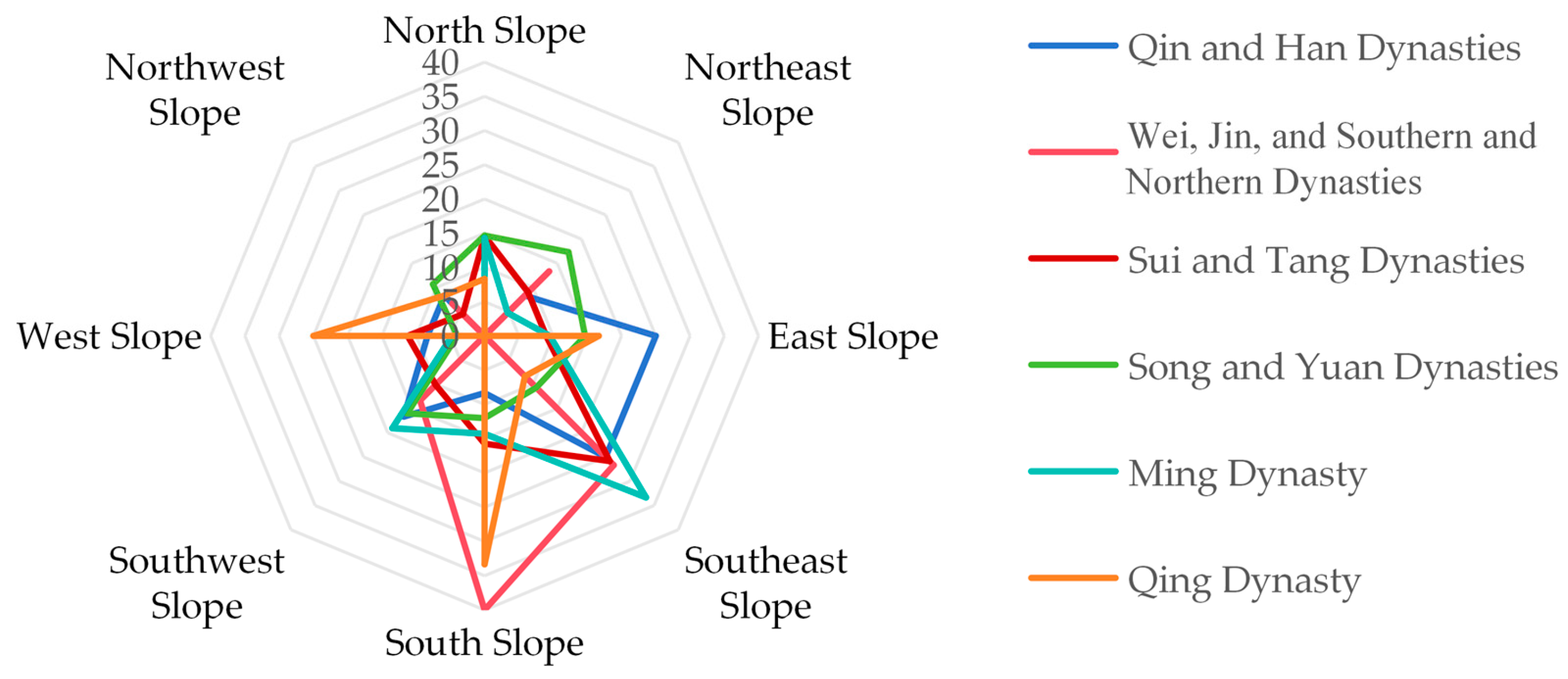
| <3° | 3–10° | 10–25° | 25–50° | |
|---|---|---|---|---|
| Qin and Han Dynasties | 0.08 | 0.42 | 0.25 | 0.25 |
| Wei, Jin, and Northern and Southern Dynasties | 0 | 0.6 | 0.33 | 0.07 |
| Sui and Tang Dynasties | 0.08 | 0.38 | 0.46 | 0.08 |
| Song and Yuan Dynasties | 0.04 | 0.29 | 0.53 | 0.13 |
| Ming Dynasty | 0.14 | 0.48 | 0.33 | 0.05 |
| Qing Dynasty | 0.17 | 0.33 | 0.33 | 0.17 |
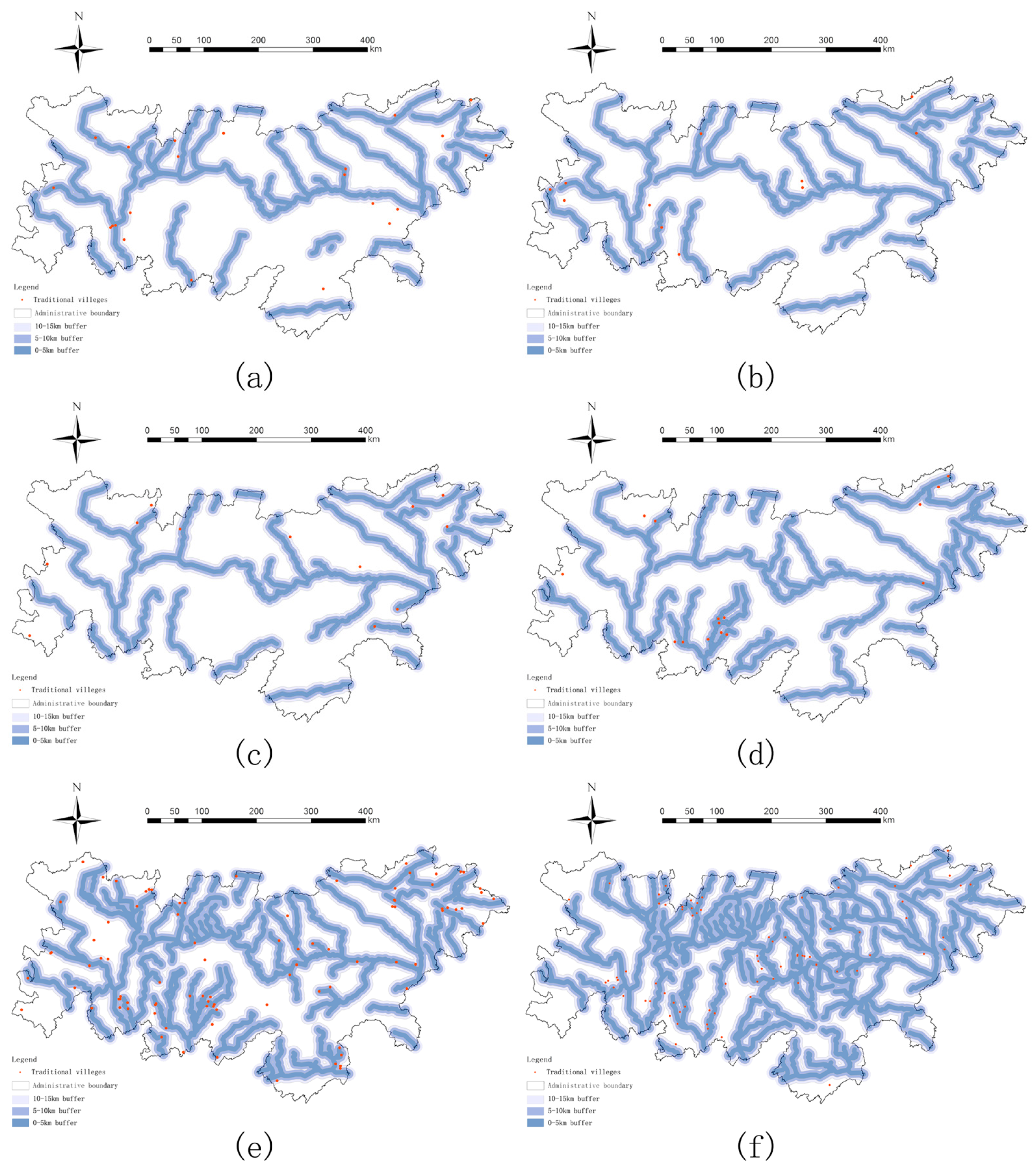
| <5 km | 5–10 km | 10–15 km | |
|---|---|---|---|
| Qin and Han Dynasties | 0.31 | 0.27 | 0 |
| Wei, Jin, and Northern and Southern Dynasties | 0.27 | 0 | 0.09 |
| Sui and Tang Dynasties | 0.16 | 0.33 | 0.16 |
| Song and Yuan Dynasties | 0.53 | 0.13 | 0.2 |
| Ming Dynasty | 0.37 | 0.25 | 0.14 |
| Qing Dynasty | 0.37 | 0.3 | 0.18 |
| <5 km | 5–10 km | 10–20 km | |
|---|---|---|---|
| Qin and Han Dynasties | 0.17 | 0.17 | 0.22 |
| Wei, Jin, and Northern and Southern Dynasties | 0.18 | 0.09 | 0.09 |
| Sui and Tang Dynasties | 0.16 | 0.16 | 0.33 |
| Song and Yuan Dynasties | 0.2 | 0.2 | 0.2 |
| Ming Dynasty | 0.11 | 0.21 | 0.11 |
| Qing Dynasty | 0.17 | 0.13 | 0.3 |
| <15 km | 15–30 km | 30–45 km | 45–60 km | >60 km | |
|---|---|---|---|---|---|
| Qin and Han Dynasties | 0.09 | 0.31 | 0.22 | 0.18 | 0.18 |
| Wei, Jin, and Northern and Southern Dynasties | 0.18 | 0.27 | 0.18 | 0.09 | 0.27 |
| Sui and Tang Dynasties | 0.16 | 0.08 | 0.41 | 0.25 | 0.08 |
| Song and Yuan Dynasties | 0.13 | 0.13 | 0.06 | 0.13 | 0.4 |
| Ming Dynasty | 0.30 | 0.49 | 0.28 | 0.08 | 0.02 |
| Qing Dynasty | 0.13 | 0.56 | 0.22 | 0.05 | 0.02 |
Disclaimer/Publisher’s Note: The statements, opinions and data contained in all publications are solely those of the individual author(s) and contributor(s) and not of MDPI and/or the editor(s). MDPI and/or the editor(s) disclaim responsibility for any injury to people or property resulting from any ideas, methods, instructions or products referred to in the content. |
© 2025 by the authors. Licensee MDPI, Basel, Switzerland. This article is an open access article distributed under the terms and conditions of the Creative Commons Attribution (CC BY) license (https://creativecommons.org/licenses/by/4.0/).
Share and Cite
Chu, T.; Liu, C. The Spatiotemporal Evolution Characteristics and Influencing Factors of Traditional Villages in the Qinling-Daba Mountains. Buildings 2025, 15, 2397. https://doi.org/10.3390/buildings15142397
Chu T, Liu C. The Spatiotemporal Evolution Characteristics and Influencing Factors of Traditional Villages in the Qinling-Daba Mountains. Buildings. 2025; 15(14):2397. https://doi.org/10.3390/buildings15142397
Chicago/Turabian StyleChu, Tianshu, and Chenchen Liu. 2025. "The Spatiotemporal Evolution Characteristics and Influencing Factors of Traditional Villages in the Qinling-Daba Mountains" Buildings 15, no. 14: 2397. https://doi.org/10.3390/buildings15142397
APA StyleChu, T., & Liu, C. (2025). The Spatiotemporal Evolution Characteristics and Influencing Factors of Traditional Villages in the Qinling-Daba Mountains. Buildings, 15(14), 2397. https://doi.org/10.3390/buildings15142397