Article

A Methodological Approach to Revealing the Landscape Morphology of Heijing Village Using Fractal Theory

1
School of Plastic Arts, Daegu University, Gyeongsan-si 38453, Republic of Korea
2
Department of Performing Arts & Culture, The Catholic University of Korea, Seoul 14662, Republic of Korea
*
Author to whom correspondence should be addressed.
Buildings 2025, 15(12), 2037; https://doi.org/10.3390/buildings15122037
Submission received: 29 April 2025 / Revised: 10 June 2025 / Accepted: 11 June 2025 / Published: 13 June 2025

Abstract

With the ongoing globalization, traditional villages around the world face the challenge of balancing modernization with the preservation of their cultural and spatial integrity. Heijing Village, a representative traditional settlement in Yunnan, showcases this global phenomenon through its distinctive spatial form and rich multi-ethnic cultural heritage. This study examines the landscape morphology of Heijing Village to reveal its spatial organization, cultural significance, and adaptive evolution. By applying fractal theory, we quantify the spatial complexity and self-similarity of the village, uncovering underlying patterns in land use that contribute to its sustainability and historical continuity. This study’s innovation lies in its use of fractal analysis to assess the village’s dynamic landscape, offering a novel method for understanding the interplay between traditional spaces and modern demands. The findings demonstrate variations in fractal dimension values before and after model optimization, indicating an enhanced ability to capture the intricate spatial structure of Heijing Village. Notably, changes in fractal dimensions across different land use types (e.g., residential areas: 1.4751 to 1.5323 and public service areas: 1.2846 to 1.3453) suggest improvements in quantification accuracy rather than actual physical transformations. This refined methodological framework provides a robust and replicable tool for planners to quantitatively assess the morphological characteristics of traditional settlements, supporting more evidence-based conservation strategies.

1. Introduction

Village landscapes, as vital components of world cultural heritage, encapsulate rich historical information and unique regional cultural connotations [1,2]. In recent years, the growing global awareness of cultural heritage conservation has made the protection and study of traditional villages a prominent focus in both academic research and practical applications [3]. However, the integrity of these villages is under threat from standardized planning interventions that fail to recognize their inherent organic complexity [4]. Unlike the planned grids of modern cities, settlements like Heijing have evolved through a bottom-up process adapted to local topography and social needs. The imposition of modern infrastructure, which often ignores this inherent fractal logic, poses a severe challenge to the village’s cultural and spatial identity, raising urgent questions about how to quantitatively capture and protect its unique morphology [5,6].
Heijing Village, as a representative traditional settlement, embodies a complex interplay of natural geographic conditions, historical–cultural accumulation, and social practices. The spatial layout, architectural forms, and overall landscape demonstrate distinct hierarchical and self-organizing characteristics that reflect a harmonious coexistence between humans and nature, preserved through generations. However, conventional spatial analysis methods face limitations in revealing the underlying laws of such complex systems and often struggle to quantitatively capture the multi-scale self-similarity and dynamic interactions between the village space and its natural environment [7,8].
In contrast, fractal theory—a mathematical framework—offers a precise quantification of spatial complexity and hierarchical relationships through fractal dimensions, making it especially suitable for describing irregular, fragmented, and self-similar spatial forms [9,10]. While traditional spatial syntax focuses primarily on spatial accessibility and connectivity and econometric models emphasize macro-level statistical correlations, these approaches often fail to adequately account for the influence of complex terrains and self-organizing processes on spatial development [11,12]. Fractal analysis reveals intrinsic spatial patterns across multiple scales, providing a robust quantitative framework to uncover historical landscape evolution and assess structural changes under modernization pressures [13,14].
Moreover, fractal analysis not only facilitates the understanding of the intricate interrelations between cultural and natural elements but also underpins scientifically grounded strategies for the protection and planning of traditional villages [15,16]. By quantifying spatial complexity and the hierarchical structure, this method aids in developing optimization strategies that balance ecological conservation with cultural heritage preservation, thereby maintaining the dynamic equilibrium of traditional village landscapes [17]. Importantly, fractal theory’s broad applicability allows its extension beyond Heijing Village to other historical settlements and rapidly urbanizing regions, demonstrating significant potential in spatial optimization, ecological protection, and cultural heritage conservation at a wider scale.
In summary, this study adopts fractal theory as the core analytical tool to systematically reveal the spatial complexity and intrinsic patterns of Heijing Village’s landscape, providing a scientific foundation for its cultural and ecological protection. The application of this approach aims to contribute theoretical insights and practical guidance for the sustainable development of traditional village landscapes and the global preservation of similar cultural heritage sites.

2. Literature Review

2.1. Application Background of Fractal Theory in Traditional Village Research

In recent years, fractal theory has emerged as a valuable tool in landscape studies and the preservation of traditional villages [18]. Its core concept of self-similarity enables the analysis of complex spatial patterns across multiple scales [19]. As globalization and urbanization threaten traditional villages—leading to the erosion of cultural identity, ecological degradation, and the destruction of historical landscapes—fractal theory offers a new analytical framework that highlights the inherent complexity and adaptability of these environments [20]. It has been widely applied in urban planning, ecological modeling, and historical settlement studies due to its capacity to describe nonlinear, hierarchical, and self-organizing structures [21]. Unlike modern planned cities, traditional villages often evolve organically over time, influenced by sociopolitical, environmental, and cultural factors [22,23,24]. Fractal analysis thus provides critical insights into their spatial configurations, which can inform sustainable and culturally sensitive conservation strategies.

2.2. Theoretical Controversies and Limitations of Previous Studies

Despite its growing popularity, the application of fractal theory in the study of traditional villages remains contested [25,26]. One major issue lies in the inconsistency of fractal dimension calculations across different studies [27]. Methods involving box counting, the boundary dimension, and the information dimension often yield disparate results, primarily due to variations in algorithm selection, grid size, image resolution, and data preprocessing [28]. This lack of standardization complicates the direct comparison between studies and reduces the reliability of the findings [29]. Moreover, while the theory assumes scale-invariant self-similarity, real-world village systems may experience disruptions at certain scales due to external factors such as policy interventions, urban expansion, or natural disasters [30]. These factors can cause the breakdown of self-similarity, thus challenging the core assumptions of the theory.
Another common limitation in previous research is the absence of methodological transparency [31,32]. Many studies do not clearly explain how spatial data were collected, processed, or analyzed, nor do they discuss how algorithmic parameters were selected [33]. As a result, these studies are often difficult to replicate or evaluate. Additionally, much of the existing work is narrowly focused on the morphological aspects of the village form, overlooking the complex interactions between spatial structures and social or cultural systems [34,35]. Without interdisciplinary integration, the explanatory power of fractal analysis remains limited. Therefore, while fractal theory holds significant promise, there is a pressing need for methodological refinement, empirical validation, and theoretical integration with other disciplines.

2.3. Methodological Refinement and Comparison with Alternative Approaches

Fractal theory has been widely employed to analyze spatial complexity in traditional villages [36,37,38]. However, its application has often been limited by inconsistent calculation techniques, a lack of methodological refinement, and minimal comparison with alternative spatial analysis tools [39]. While earlier studies have utilized fractal dimensions to interpret village morphology, many fail to address the computational limitations, data sensitivity, and contextual adaptability of such methods [40].
In this study, we refine the box-counting method through several technical improvements tailored to the irregular and hierarchical spatial patterns found in traditional settlements. Specifically, we optimize image resolution, calibrate the grid scale to local morphological features, and introduce land-use-type differentiation to avoid homogenizing spatial categories. These enhancements aim to improve both the accuracy of calculated fractal dimensions and their comparability across studies and regions.
To highlight the unique strengths of our approach, it is essential to situate fractal analysis within the broader context of quantitative spatial methods. Two prominent alternatives frequently applied in spatial morphology studies are space syntax and landscape metrics. The following table summarizes the key distinctions among these approaches (Table 1):
While space syntax is valuable for analyzing visual or functional flows in urban settings and landscape metrics offer insights into ecological patch structures, fractal analysis excels in capturing the nested, self-similar, and adaptive qualities of organically grown settlements, such as those found in mountainous or ethnically diverse regions like Yunnan [41,42,43]. Furthermore, by focusing on spatial form rather than movement or function alone, fractal theory provides a distinct lens to examine how traditional villages evolve under cultural and environmental pressures.
Our methodological refinement does not aim to replace existing tools but to complement them by addressing spatial characteristics that are often overlooked—especially the continuity of form, the gradation of density, and scale sensitivity inherent to traditional villages. In this way, our study contributes a theoretically grounded and technically improved application of fractal theory, offering a reliable framework for a cross-cultural and cross-regional comparison of traditional settlement patterns under globalization.

3. Methods and Materials
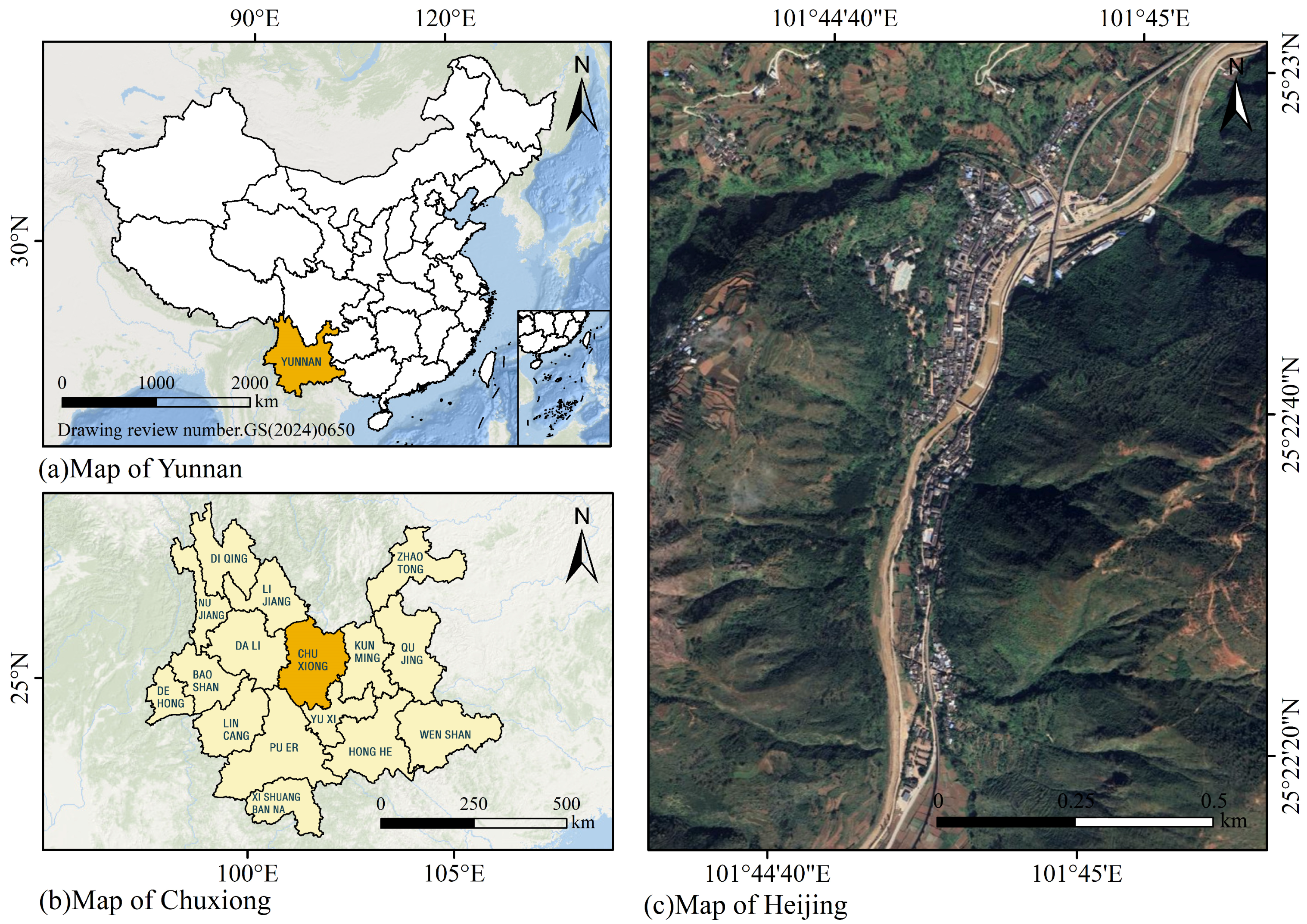
3.1. Study Area

Heijing Village is located in the northwestern part of Lufeng City, Chuxiong Yi Autonomous Prefecture, Yunnan Province (Figure 1). Nestled amid encircling mountains and traversed by winding rivers, it is a traditional village with a long-standing history and rich cultural heritage. To its east lies Gaofeng Township; to the south it borders Tuo’an Township; to the west it connects with Xinqiao Town and the Anle Township of Mouding County, and to the north it neighbors the Huatong Township of Yuanmou County. With a total area of 133.6 square kilometers, Heijing enjoys a distinctive geographic position, convenient transportation, and evident regional advantages. Administratively, the village comprises one residential community and eight administrative villages. As of 2019, it had a registered population of 18,023, forming a typical settlement pattern for inland mountainous areas of southwestern China.
Situated in the midstream valley of the Longchuan River—a tributary on the right bank of the Jinsha River—Heijing’s terrain alternates between mountains and river valleys. The land stretches in a north–south direction while remaining narrow from east to west, giving the area distinct topographical characteristics. The village’s highest point is Shipopo Mountain, with an elevation of 2498 m, and its lowest point is at the confluence of the Yibi River, at 1323 m, resulting in a vertical elevation difference of 1175 m. The town’s government sits at an altitude of 1540 m. The area enjoys an average annual temperature of 18.7 °C, an annual precipitation of 857 mm, a frost-free period of 325 days, 1848 h of sunlight per year, and an accumulated temperature of 7774.8 °C, characterizing it as a mild river valley climate with prominent vertical zonation. This unique combination of geography and climate not only supports agricultural development and human settlement but also historically positioned Heijing as a strategic transportation hub in central Yunnan.
In recent years, with the advancement of cultural heritage preservation efforts, Heijing Village has been recognized as a historical and cultural town by the Yunnan provincial government. Its deep historical roots and well-preserved traditional landscape have attracted numerous historians, cultural researchers, and tourists, establishing it as a significant cultural tourism destination in central Yunnan.

3.2. The Relationship Between Fractal Theory and Landscape Morphology

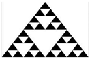
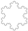
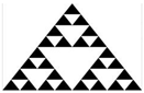
3.2.1. Selection of Fractal Measurement Methods

Fractal dimension measurement methods are among the most developed and mature quantitative indicators within fractal theory [44,45,46]. With the continuous advancement of fractal theory, the quantification of fractal objects is generally categorized into three types based on their spatial characteristics: point, line, and surface. Corresponding quantitative indicators include the correlation dimension, the box-counting dimension, the length dimension, the branch dimension, and others (see Table 2).
In this study, the observational scale is set at the spatial extent of natural villages. This choice is grounded in the understanding that a village, as the fundamental unit of rural spatial organization, constitutes a complete and analyzable morphological system. Selecting the village scale enables a more accurate and contextually meaningful assessment of boundary complexity, spatial fragmentation, and self-similarity. Furthermore, this scale corresponds to the minimum unit typically used in rural planning and geographic zoning, ensuring that the surface-based box-counting dimension accurately reflects the actual spatial characteristics of the villages. This approach enhances both the reliability and interpretability of the fractal analysis results.
This paper employs the box-counting dimension method, a widely applicable and mature approach within fractal theory. This method minimizes human error and does not require complex analytical operations [47]. In this study, the observational scale is set to the scale of natural villages, which is determined based on the typical spatial extent and settlement patterns characteristic of such villages. Selecting this scale ensures that the fractal analysis captures the relevant structural features without excessive noise from finer or broader spatial elements. Although the accuracy of the box-counting dimension can be influenced by image resolution and scale selection, this approach offers clear advantages over other fractal measurement techniques, such as perimeter-based or arbitrary observational-scale methods [48].

3.2.2. Fractal Dimension Grid Space Representation

Grid space representation is a key technique in fractal theory, as it is fundamental to calculating fractal dimension results in this study [49]. The accurate analysis of the grid space is essential for obtaining reliable fractal data. In planar morphological fractal analysis, spatial representations differ between one-dimensional and two-dimensional spaces, with fractal dimensions ranging between 1 and 2 [50]. Historically, urban development studies using fractal theory have used a fractal dimension of 1.5 as a threshold: urban boundaries with fractal dimensions above 1.5 are considered mature, while those below 1.5 are classified as immature development forms.
However, fractal grid space representation for traditional villages cannot be generalized from urban development models. Unlike cities, which typically expand through top-down planning, traditional villages evolve via bottom-up renewal processes. Due to these fundamental differences, traditional villages exhibit unique fractal dimension characteristics [51]. This study’s evaluation system incorporates multiple fractal analyses tailored to the diverse morphologies of villages and towns.

3.3. Fractal Dimension Calculation of Heijing Village’s Spatial Morphology

Compared to conventional disciplines, fractal theory offers significant advantages in describing irregular shapes, which often exhibit organizational patterns consistent across multiple scales [52]. The spatial morphology of traditional villages, similar to leaf vein structures, shows closely related internal characteristics and variations that can be described through self-similarity. In this study, spatial morphologies exhibiting such self-similar features are selected for analysis. By expressing fractal dimensions as non-integers, this approach intuitively captures changes, trends, and environmental impacts across different land types.
For Heijing Village, fractal dimension calculations cover various spatial components: the external village boundary, building morphology, residential land, public service land, road land, agricultural land, and water bodies—each quantified by box-counting dimension analysis.

3.4. Model Construction

(1)
Data Acquisition
Village landscape boundaries were extracted using Google Earth (https://earth.google.com/web/) imagery acquired on 11 May 2024, with level 18 data, where the pixel size is 1.07 m. This high resolution allowed for a detailed analysis of the spatial structure of the natural villages, capturing both fine details and broader patterns of land use. Field surveys were conducted to verify land use types and confirm land cover types. A total of 50 sampling points were randomly selected within the study area to validate classification accuracy. The surveys used a stratified random sampling approach to ensure that all relevant land use categories, such as residential, agricultural, and public service areas, were adequately represented. The data obtained from these field surveys was compared with the satellite imagery to ensure consistency and improve the reliability of the classification process.
Ensuring the accuracy of land use types and the reliability of data was crucial. The accuracy of the boundary extraction process was further refined by manually correcting initial automated results. This was necessary to minimize any errors caused by image distortions, such as those introduced by cloud cover or shadows. Additionally, the land use classification was validated by comparing it to the field survey data, achieving an overall classification accuracy of 92%. This validation process ensured that the remote sensing data accurately reflected the actual land use patterns within the village.
(2)
Binarization of Fractal Images
Fractal image analysis begins with image binarization. Prior to box-counting dimension calculations, the images are converted to grayscale [53,54]. In MATLAB (R2023a), images consist of pixels, each carrying color information stored in a matrix where each element corresponds to a pixel’s color or indexed color value. The area of interest was extracted, converted to grayscale, and processed to detect boundaries and binarize the image.
Following conversion, the village’s spatial boundaries are represented as black-and-white bitmaps, with pixel information used for fractal dimension measurement. The box-counting dimension method was selected for its proven effectiveness and computational simplicity in digital image-based fractal analysis. Compared to other methods like the Hausdorff dimension or mass–radius approaches, box counting is straightforward to implement on binary images and excels at capturing spatial complexity and scale invariance in irregular morphological structures such as village boundaries.
Additionally, the box-counting method enjoys widespread adoption in landscape ecology and urban morphology, making it well-suited for the MATLAB-based workflow used in this study.
(3)
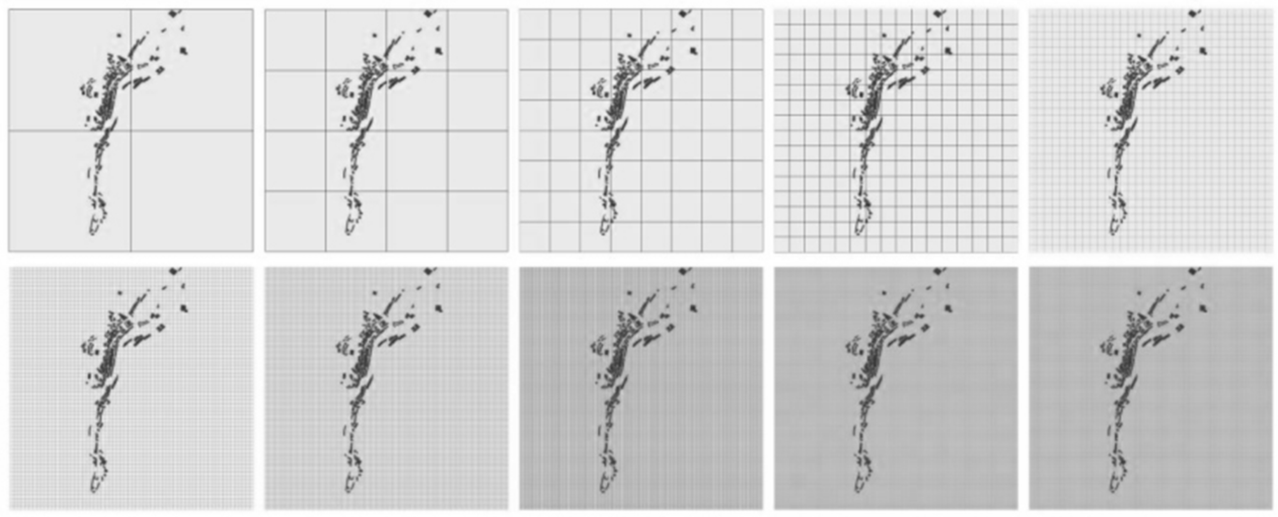
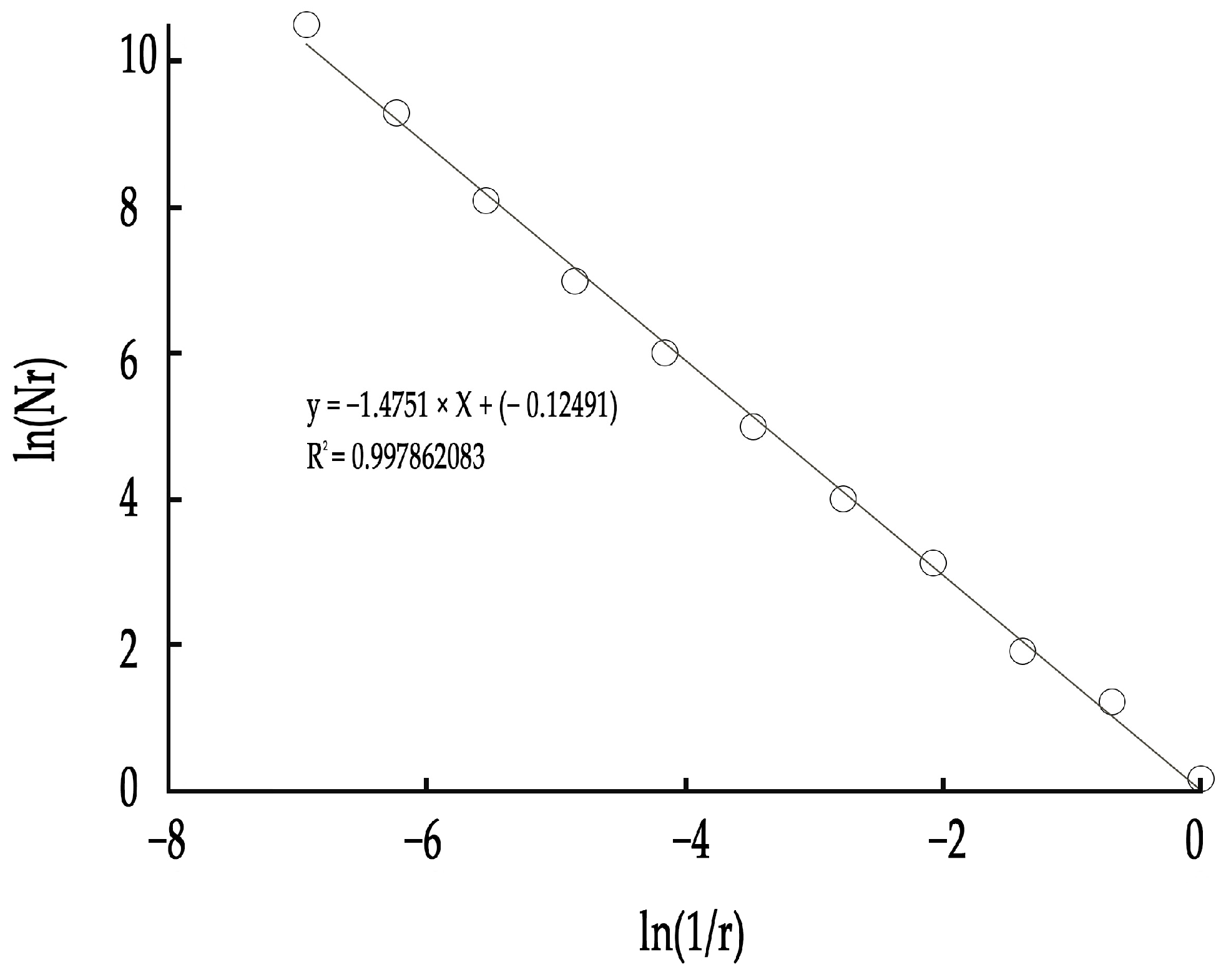
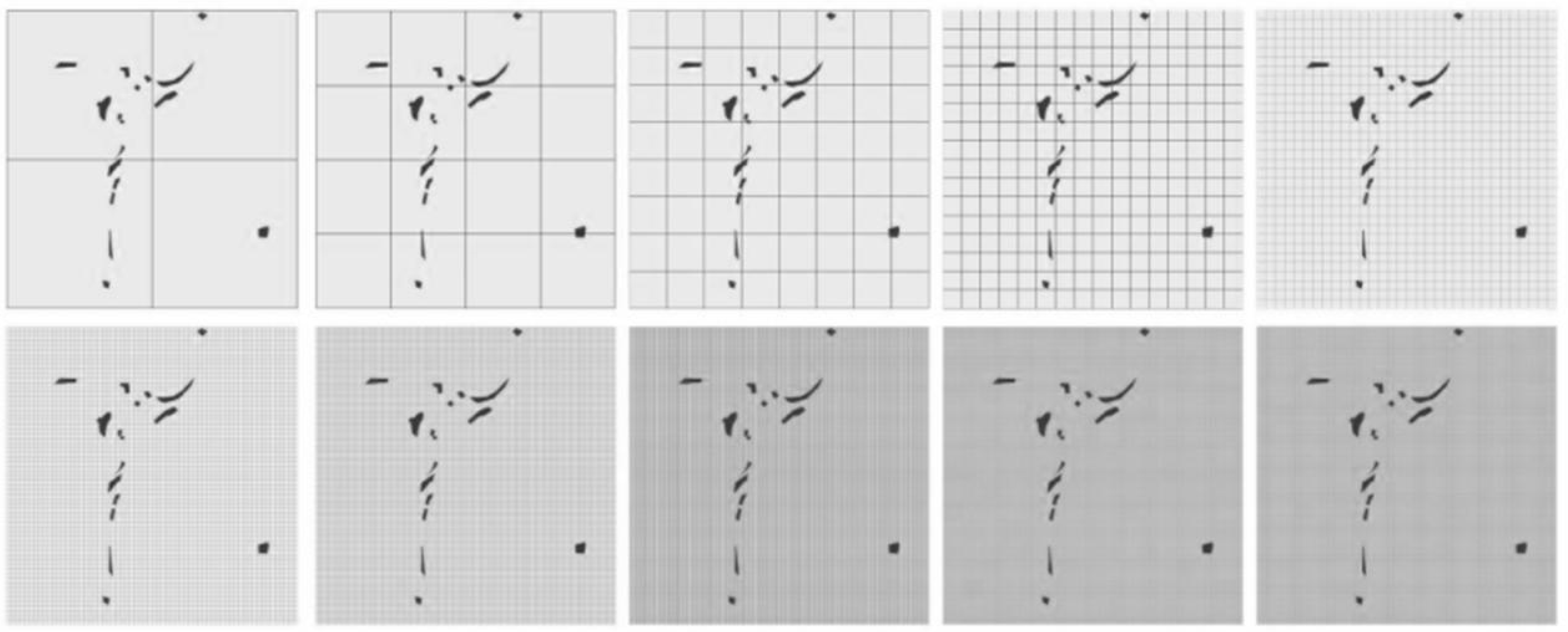
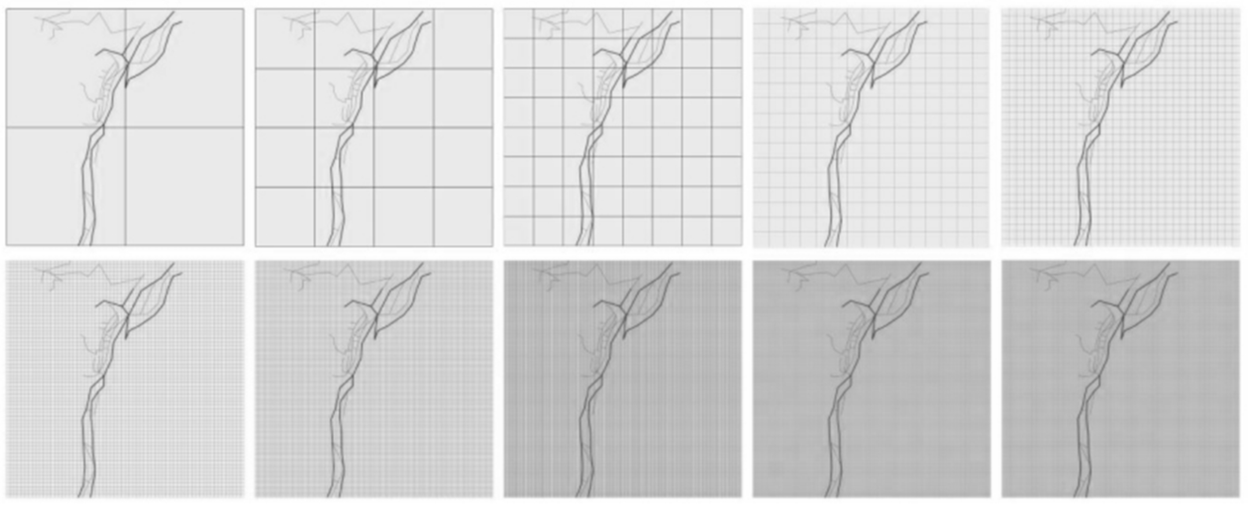
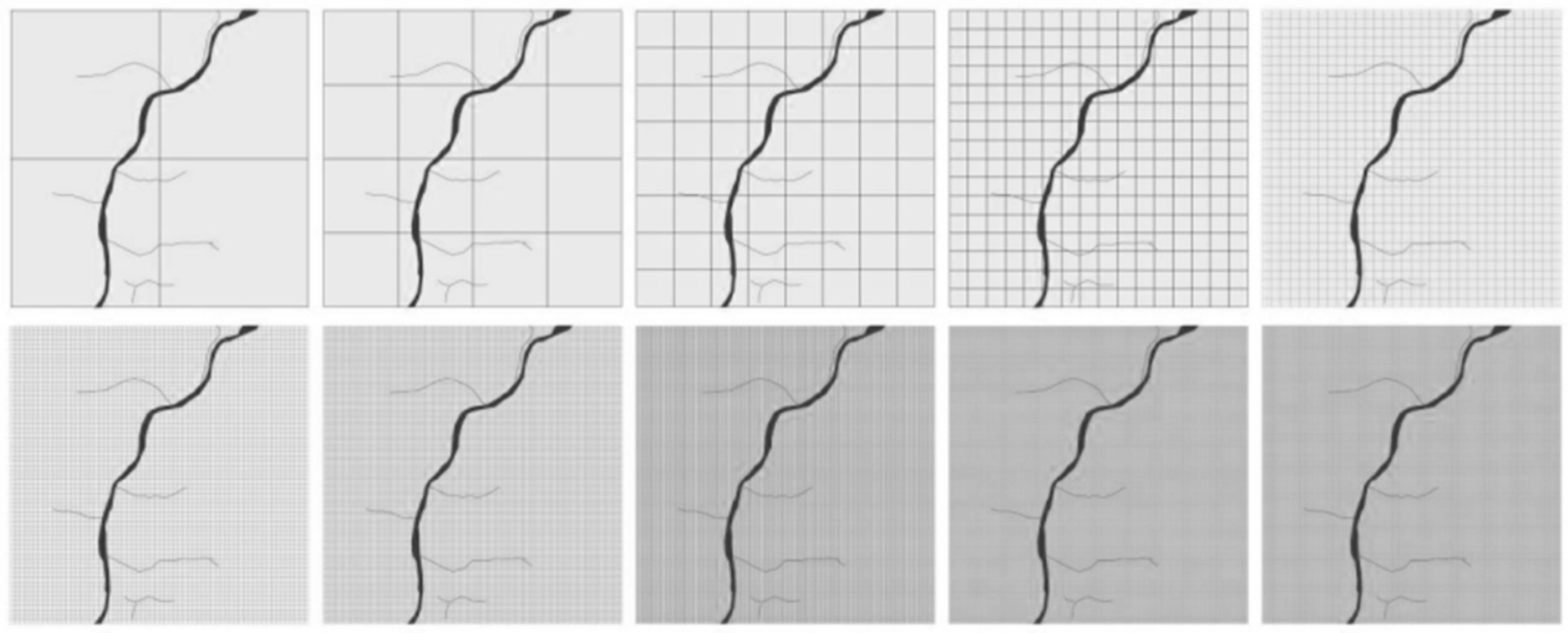
Box-Counting Dimension Process
Based on the principles and procedures for calculating the box-counting dimension, a program was developed to perform grid partitioning on the binarized image and count the number of non-empty grid cells.
The box-counting method was chosen due to its computational simplicity, suitability for analyzing fractal-like structures in binary images, and widespread application in similar image-based complexity analyses [55,56]. Compared with other fractal dimension estimation methods such as the Hausdorff dimension or the correlation dimension, the box-counting dimension offers a balance between accuracy and implementation efficiency, particularly when dealing with pixel-based digital images [57,58]. The Hausdorff dimension, while mathematically rigorous and widely regarded as the most precise fractal dimension, is often computationally intensive and challenging to approximate in discrete digital contexts [59,60]. Similarly, the correlation dimension requires large datasets and involves complex calculations of point-to-point distances, which may not be feasible or efficient for image data with limited resolution [61,62]. In contrast, the box-counting method simplifies the estimation process by overlaying grids of varying sizes and counting occupied cells, making it highly adaptable to binary images and relatively straightforward to implement algorithmically [63,64]. This method also provides consistent and reproducible results even when applied to noisy or imperfect data, which is common in real-world image analysis scenarios. Therefore, the box-counting dimension serves as a practical and reliable choice for quantifying the fractal characteristics of digital images, balancing theoretical robustness with computational practicality. Let the initial grid size be denoted as r 0 . The grid undergoes n iterations of bisection, where at each iteration the grid size is halved. After the i -th iteration, the grid size is
r i = r 0 2 i ( i = 0 , 1 , 2 n )
For each grid size r i , the number of non-empty cells containing part of the fractal pattern is recorded as N r i .
If the image exhibits fractal characteristics, the relationship between N r and r approximately follows a power law of the form
N r r D
where D is the fractal dimension. Taking the logarithm of both sides yields a linear relationship:
log N ( r ) = D log r + C
where C is a constant. By plotting log N ( r ) against log r on a double-logarithmic scale and performing linear regression, the negative slope of the fitted line corresponds to the fractal dimension D :
D = d log N ( r ) d log r
Theoretically, for planar fractal shapes, the fractal dimension D satisfies 1 ≤ D < 2. Larger values of D indicate more complex and detailed planar features, while smaller values correspond to simpler, less detailed structures (see Figure 2).

4. Fractal Dimension Calculation for Different Land Use Types

Land use types were selected based on widely accepted classification schemes, focusing on those most representative for fractal dimension measurement [65]. Different land use categories require tailored analytical methods. While traditional approaches represent buildings primarily as surfaces and roads as lines, this study additionally accounts for the distinctive construction patterns of traditional villages and the particular spatial textures characteristic of Heijing Village.

4.1. Residential Buildings

The spatial arrangement of residential buildings generally follows a planar distribution pattern, reflecting a preference for well-connected, accessible, and conveniently navigable residential areas. An ideal residential layout demonstrates strong internal connectivity and good transportation accessibility [66].
In the case of Heijing Village, the overall spatial plan of residential buildings is derived from detailed land cover classification. Initially, the original layout map is digitized and converted into a grayscale image. This grayscale image is then transformed into a binary image, which serves as the input for fractal dimension analysis (see Figure 3).
A grid is overlaid onto the residential building contours of Heijing Village, and boxes intersecting with the buildings are recorded as non-empty. At each iteration, the grid size is halved, and the number of non-empty boxes is counted at that scale. This iterative procedure continues across multiple scales, ranging from 2 to 1024 units. The resulting data provide a detailed quantitative description of the spatial distribution of residential buildings, offering insights into the structural complexity and spatial organization of the village. By analyzing the changes in the count of non-empty boxes across scales, it is possible to identify self-similar patterns inherent in the village’s spatial configuration, which may contribute to informing future preservation and planning strategies [67]. This fractal approach is particularly useful for assessing the resilience of traditional villages to modern urban pressures and guiding sustainable rural development.
With the gradual development of the local economy, land use in Heijing Village has experienced significant changes. Notably, following national rural land policy reforms, there has been an increase in land transfers. Portions of land previously used for agricultural production have been converted into residential areas, leading to a more compact residential layout and accelerating urbanization. The government has played a key role in this transformation by promoting building intensification through land consolidation and infrastructure improvements, such as enhanced transportation networks. These measures have contributed to reducing the formerly scattered spatial pattern of residences.
Additionally, local policies—including fiscal incentives for rural housing construction and adjustments in land use planning—have influenced the residential layout. These policies have fostered the development of more concentrated and structurally complex residential areas. Consequently, the spatial configuration of buildings and the lifestyle patterns of villagers have shifted, partially transitioning the village away from its original organic growth model.
The fractal dimension for the residential buildings of Heijing Village is 1.4751 (Figure 4). This value, midway between a simple line (D = 1) and a plane-filling pattern (D = 2), quantitatively reflects a moderately complex and space-filling layout. This is the spatial signature of a settlement that has evolved organically, adapting to topographical constraints rather than following a rigid grid. This value suggests a structure more intricate than a simple linear village but less dense than a fully urbanized area, capturing the essence of its semi-rural, historically layered morphology.

4.2. Village Public Service Land

The accessibility of public service land in a village plays a critical role in shaping the daily lives of its residents [68,69]. In Heijing Village, these areas—such as public parking lots, the tourist parking lot, the Yanjing Cultural Museum, and the local market (Figure 5)—serve as key nodes in social and economic life. However, several issues were identified, including loose spatial connections among service areas and inefficient transportation axes. These deficiencies highlight the need for integrated infrastructure planning to enhance connectivity and accessibility.
Such spatial disconnection can hinder economic activities by increasing the travel time and reducing villagers’ access to essential services like healthcare, education, and commerce. This in turn weakens the flow of people, goods, and services, ultimately impacting the local economy.
To assess spatial organization, images of identified public service lands were processed—first converted to grayscale, then binarized—and analyzed for fractal dimension. The resulting value of 1.2846 (Figure 6) suggests a relatively low level of spatial complexity, indicating a layout that is more linear or simplistic. This reflects the current developmental stage of the village and the limited integration of public spaces. The low fractal dimension also supports observations regarding inefficient land use and weak connectivity.

4.3. Village Road Land

Road land in a village serves a distinct and vital function, acting as the connective tissue that links different areas and facilitates mobility [70,71]. In Heijing Village, the road network consists of multiple hierarchical tiers, including the Chengkun Line, county-level highways, primary tourist routes, cultural streets, and secondary roads. Accurately identifying and mapping these various road types is essential for comprehending the village’s spatial organization and accessibility patterns (Figure 7). Each road category serves different purposes and exhibits varying degrees of connectivity, thereby influencing the movement of residents and visitors throughout the village.
By proportionally mapping these road levels, fractal dimensions can be calculated for each category. These fractal dimension values quantitatively characterize the complexity of the road network and its effectiveness in connecting different village sectors. A higher fractal dimension reflects a more intricate and highly interconnected road system, enhancing accessibility and ease of movement, whereas a lower fractal dimension indicates a simpler, potentially less efficient network.
This fractal analysis offers valuable insights for future infrastructure planning. Areas exhibiting lower fractal dimensions, which suggest poor connectivity or network inefficiency, can be prioritized for targeted road improvements. Such interventions may include enhancing road links, optimizing traffic flow, and upgrading transport infrastructure to better serve the village’s needs. Consequently, fractal dimension analysis functions both as a diagnostic tool and a practical foundation for designing more effective road networks that support sustainable growth and improve mobility for both residents and visitors (Figure 8).

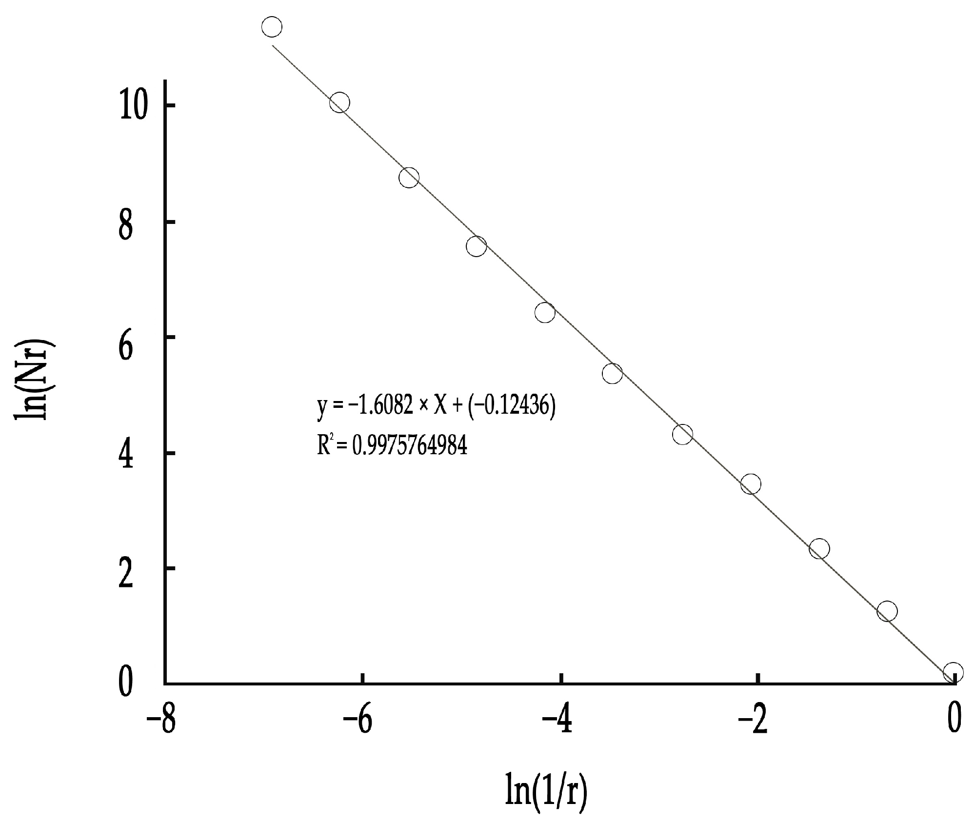
4.4. Village Agricultural Land

The planning and organization of agricultural land in Heijing Village have evolved in response to its historical development and local agricultural practices. Currently, the village’s agricultural land comprises diverse sectors, including salt production zones, crop fields, and other related agricultural uses (Figure 9). This diversity reflects a balanced approach to farming, supporting the village’s economic sustainability through multiple agricultural activities. Understanding the spatial organization of these agricultural areas is critical for optimizing land use, enhancing productivity, and maintaining ecological equilibrium.
For fractal analysis, the images of agricultural land were first converted to grayscale and then binarized. The fractal dimension calculated from these processed images quantifies the complexity of the spatial arrangement of agricultural land. Higher fractal dimension values indicate intricate, self-similar spatial patterns, while lower values reflect simpler, more uniform layouts.
The fractal dimension measurement offers valuable insights into land use patterns and their implications for agricultural efficiency, ecological sustainability, and land management strategies (Figure 10). For example, a high fractal dimension might suggest a heterogeneous and irregular spatial configuration, possibly adapted to diverse crops or varying environmental conditions. Such complexity can be advantageous for agricultural practices requiring micro-level differentiation in terrain, water availability, or sunlight exposure.
Overall, this fractal analysis provides a scientific basis for understanding and optimizing the spatial configuration of agricultural land in Heijing Village. It supports targeted interventions aimed at improving land use efficiency and sustainability, ensuring that agricultural practices evolve in harmony with environmental dynamics while preserving the village’s agricultural heritage.

4.5. Water Bodies

The fractal dimension of the water bodies in Heijing Village was calculated to be 1.3886 (Figure 11), indicating a moderate level of spatial complexity and self-similarity. This reflects the organic and meandering characteristics typically found in natural water systems, influenced by both environmental factors (such as terrain and hydrology) and human interventions like water management and land use planning.
Such fractal characteristics arise from the interplay of multiple environmental factors, including terrain variations, hydrological processes, and soil properties, which collectively influence the shape and flow paths of water. The self-similar nature implied by the fractal dimension indicates that these patterns repeat across different spatial scales, a hallmark of many natural phenomena. Moreover, the shape and spatial distribution of these water bodies are also shaped by human activities such as water management and land use planning. These interventions can either enhance or disrupt the natural complexity, affecting both the ecological functions and esthetic qualities of the water system.
Therefore, the fractal dimension of 1.3886 not only quantitatively captures the water bodies’ intermediate complexity but also reflects the dynamic balance between natural environmental forces and anthropogenic influences (Figure 12). This measure provides a valuable insight into the spatial organization and management of aquatic ecosystems in Heijing Village.

4.6. Fractal Dimension Statistics of Various Land Use Types

The fractal dimension model was used to quantify various land use types in Heijing Village. This analysis focused on residential areas, public service land, road land, agricultural land, and water bodies (Table 3). The fractal dimension results for each land use type are summarized as follows:
Image recognition processes inherently possess certain limitations, particularly related to image resolution [72]. Selecting an appropriate resolution is essential to accurately represent fractal dimensions. Both theoretical fractals and real-world fractal objects contain infinite levels of detail; however, during image processing, the smallest pixel unit has a finite size and cannot be subdivided further. This constraint limits the precision of fractal dimension measurements derived from digital images.

4.7. Validity Analysis

To improve the accuracy of fractal dimension calculations for Heijing Village, this study employs classical fractal shapes—namely, the Koch curve and the Sierpinski triangle, rectangle, and straight line—as benchmarks for validating measurement accuracy. By comparing fractal dimensions measured from these theoretical fractals with those derived from village data, the reliability and precision of the fractal dimension results are assessed and optimized (Table 4).
The results show that the relative error of the model falls between approximately 5% and 8%, indicating a generally reliable level of accuracy in the fractal dimension calculations. This level of precision suggests that the model performs well in capturing the overall morphological characteristics of Heijing Village, particularly in terms of its spatial complexity, settlement patterns, and structural coherence.
The fractal dimension, as a mathematical abstraction of spatial complexity, offers valuable insights into the self-similar and hierarchical features of the village’s morphology. However, it is important to recognize that the 5–8% relative error introduces a degree of variability that may influence the interpretation of more delicate spatial features. For instance, when analyzing the intricacy of perimeter outlines, the clustering of courtyard units, or the distribution of transitional spaces such as alleys and thresholds, this error margin may obscure subtle but meaningful patterns. In particular, features that exist at or near the resolution limit of the dataset are more likely to be affected, potentially leading to slight over- or underestimation of their structural contribution to the overall fractal geometry.
Despite these limitations, the relatively low error can be attributed to a combination of methodological rigor and effective technical implementation. The analytical framework employed in this study integrates the well-established fractal theory with a structured data workflow, minimizing the risk of noise and distortion. MATLAB (R2023a) was used for both computation and visualization, providing not only rapid processing of high-volume spatial data but also enabling dynamic interaction with intermediate outputs for validation purposes. The platform’s algorithmic stability and reproducibility further reinforce the robustness of the results.
Moreover, the careful selection of scale thresholds, the use of image preprocessing techniques to enhance edge definition, and the multi-step verification of data quality all contribute to the reliability of the final fractal measurements. These technical safeguards help ensure that the model maintains consistency across different spatial extents and levels of detail.
In summary, while the model may not fully capture every subtle morphological nuance—especially those operating at very fine spatial scales—it nonetheless offers a sound and defensible quantitative basis for analyzing the overarching spatial form of Heijing Village. The findings can thus be confidently used in comparative studies, historical morphology research, and rural spatial planning, provided that the inherent limitations posed by the error range are appropriately acknowledged and taken into account to ensure the scientific rigor and reliability of the interpretations.

5. Construction of the Fractal Dimension Optimization Model

5.1. Optimization Model: Methods for Reducing Human Error

The importance of analyzing various elements in Heijing Village lies in proposing tailored solutions for different land use types. The current issues in Heijing Village are reflected in the fractal dimensions of these land use categories. As shown in the previous chapter, the magnitude of errors impacts final computation results, rankings, and other outputs. By integrating pixel analysis with theoretical fractal dimensions, this paper proposes an optimized approach to image analysis of natural landscape morphology.
Based on the error data analysis of the ideal model (Table 5), the fractal dimension measurement of natural boundary morphology exhibits little correlation with the developmental trend of boundary morphology. For specific images, two-dimensional images achieve higher accuracy with more refined box-counting iterations, while one-dimensional images yield more accurate results using simpler box-counting iterations. This indicates that in the proposed model, graphics with more details can be effectively covered and measured using a high-order box-counting approach. When accurate data cannot be obtained with high-order box division, the underlying cause is often the limited detail and pixel resolution of the image itself, restricting the ability to accurately describe the true nature of the object.

5.2. Optimization Strategy for the Box-Counting Fractal Dimension Model

(1)
Data Processing Using the MATLAB (R2023a) Software
MATLAB (R2023a) is utilized for image data processing [73]. Its image processing tools enhance boundary detection and enable precise binarization using Otsu’s thresholding method, converting grayscale images into their binary form for fractal analysis.
(2)
Selecting the Appropriate Image Resolution
Choosing the correct image resolution is critical to accurately calculating the box-counting fractal dimension across land use types. Processed GIS data converted to binary images inherently limit the detail. Higher-resolution images capture finer boundary details, while a lower resolution can cause loss or distortion. Sensitivity to resolution varies:
Residential Areas: Complex spatial patterns require higher resolution for accurate building boundary delineation.
Public Service Areas: Structures and densities are stable enough for a moderate resolution to suffice.
Roads: Linear features require a higher resolution to avoid blurring, which affects fractal dimension extraction.
Agricultural Land: Larger, regular parcels are less sensitive to a lower resolution, though finer details benefit from a higher resolution.
Water Bodies: Irregular shorelines demand a higher resolution to capture fractal characteristics accurately.
To balance accuracy and efficiency, binary images at 1000 × 1500 pixels are used. The impact of resolution variation on fractal dimension results is further analyzed to validate this choice.
(3)
Choosing Grid Division and the Number of Steps
When using binary segmentation, incomplete coverage leads to empty boxes, introducing errors in fractal dimension calculations, especially at smaller scales. The spatial characteristics of land use types influence optimal grid division:
Residential and Public Service Areas: Uniform spacing limits grid errors, but overly large grids can miss finer boundaries.
Roads: Fine grid division is necessary to preserve road width and curvature accuracy.
Agricultural Land: Regular shapes reduce sensitivity to grid size, though small plot details may be lost with large grids.
Water Bodies: Complex shorelines require small grids to retain detail.
A 12-step binary division method is adopted after comparative analysis to optimize fractal dimension measurements. Grid size impact is also evaluated to ensure robustness across land uses.

5.3. Analysis of Optimization Data and Model Optimization Advantages of Each Land Use Type

After model optimization, data analysis and the summary of each land use type are conducted, and the statistical table of the fractal dimension of each land use type is summarized as follows (Table 6).
The main advantage of the optimized box-counting fractal dimension model lies in its improved ability to more accurately capture the spatial organization of traditional village environments. By refining the image processing steps—addressing issues such as resolution loss, edge distortion, and classification ambiguity—the model effectively reduces both systematic and random errors [74]. Consequently, the fractal dimension values obtained better represent the true spatial complexity of the environment studied.
For example, in Heijing Village, the application of the optimized model increased the fractal dimension of residential areas from 1.4751 to 1.5323, an approximate rise of 3.9%. This increase does not reflect actual changes in the built environment; rather, it indicates that the revised method more effectively captures the multi-scale heterogeneity and spatial irregularities characteristic of vernacular settlement patterns. Similar improvements were observed in other land use types: public service areas rose by 4.7% (from 1.2846 to 1.3453), roads by 1.9% (from 1.4011 to 1.4283), agricultural land by 2.2% (from 1.6082 to 1.6429), and water bodies by 3.2% (from 1.3886 to 1.4336). These increases reflect reduced classification bias and subjectivity, resulting in more objective and consistent spatial representations.
These quantitative enhancements are grounded in a more rigorous image preprocessing and analysis protocol, which incorporates refined edge detection, adaptive thresholding, and standardized grid partitioning. These improvements enable more accurate boundary recognition and the systematic handling of spatial discontinuities—both essential for fractal analysis of organically developed environments. As a result, the data is internally more consistent and more robust for comparative morphological studies.
Beyond this case study, the optimized model shows strong potential for broader applications in analyzing complex spatial morphologies. It is well-suited for heritage villages with layered historical development, ecological transition zones, and informal or polycentric historic urban cores, as well as mixed-use urban fabrics, peri-urban areas, and informal settlements—contexts where conventional spatial metrics often fall short due to irregular geometries.
Methodologically, embedding this model within a MATLAB-based analytical framework standardizes the process, enhancing replicability across regions and disciplines. This allows for more consistent, data-driven assessments of spatial complexity, offering practical value to urban planners, landscape architects, conservationists, and policymakers.
As traditional and rural settlements face ongoing challenges from urbanization, land use changes, and environmental pressures, the optimized fractal dimension model provides a reliable scientific tool for spatial analysis. Its strength lies not in measuring physical transformations directly but in improving the precision and interpretability of spatial data, thereby supporting more nuanced, evidence-based strategies for planning, preservation, and adaptive management.

6. Discussion and Suggestions

6.1. Discussion

Our findings contribute to the ongoing discussion about the utility of fractal analysis in landscape studies. While methods like space syntax effectively model connectivity in planned environments, our results demonstrate the unique strength of fractal theory in quantifying the inherent complexity of an organically evolved settlement like Heijing Village [75]. The optimized fractal dimensions we calculated do not merely describe the form; they reveal the underlying spatial logic shaped by generations of adaptation to local topography and cultural practices, a nuance often missed by other quantitative methods.
Compared with conventional spatial analysis methods, fractal analysis offers a more precise description of spatial complexity and hierarchical relationships, proving particularly valuable for studying irregular settlement structures [76]. While spatial syntax, for instance, helps reveal spatial accessibility, it struggles to quantify the impacts of complex terrain and self-organizing structures on spatial development [77,78]. Fractal analysis, conversely, measures spatial complexity through fractal dimensions, providing a refined quantitative tool for urban and rural planning [79,80]. This methodology is not only applicable to Heijing Village but can also be extended to other historical settlements and rapidly urbanizing regions, demonstrating broad potential in spatial optimization, ecological conservation, and heritage protection.
The results indicate variations in the fractal dimensions of different land use types in Heijing Village. For example, the fractal dimension of residential areas increased from 1.4751 to 1.5323, while that of public service areas rose from 1.2846 to 1.3453. The increase in the fractal dimension of residential areas corresponds to a denser and more compact building layout. This is further supported by GIS-based measurements: the average inter-building distance decreased from 5.3 m to 4.5 m, and the average building coverage ratio increased from 45% to 53%. These metrics confirm a more intensive use of space, likely a response to population concentration and land resource constraints.
Similarly, the rise in the fractal dimension of public service areas aligns with changes in infrastructure allocation. The number of small-scale public facilities (e.g., clinics, community centers, and rest areas) within a 500 m walking buffer increased by 38%, indicating a more distributed and accessible service network. This suggests improvements in spatial efficiency and service reach.
Despite its contributions, this study has certain limitations that warrant further exploration [81,82]. The current analysis focuses primarily on macro-scale spatial characteristics and does not provide a detailed examination of internal structures within different land use types. Future research could integrate remote sensing data and spatiotemporal modeling to investigate the dynamic evolution of settlement morphology in greater depth. It is important to acknowledge, however, the limitations of applying two-dimensional fractal landscape analysis in regions where topography significantly influences settlement patterns [83,84]. In mountainous areas like Heijing Village, terrain features such as the slope, elevation, and aspect play crucial roles in shaping land use and spatial organization. The current two-dimensional fractal dimension analysis may not fully capture these three-dimensional topographic constraints and their effects on village morphology. This limitation highlights the need for a more cautious approach when interpreting settlement patterns based solely on two-dimensional fractal metrics. Since traditional villages like Heijing are often molded by complex topographies, relying exclusively on planar analysis may obscure important spatial dynamics influenced by elevation and terrain. To address this, future research should consider incorporating digital elevation models (DEMs) or three-dimensional spatial analysis, allowing for a more nuanced understanding of how landform constraints interact with settlement form and development trajectories.

6.2. Suggestions

This study’s fractal dimension analysis quantitatively reveals the spatial complexity and optimization potential across different land use types in Heijing Village. The observed increases in fractal dimension values indicate improved spatial efficiency and integration. Based on these findings, the following targeted recommendations are proposed:
(1)
Optimize Residential Land Use and Promote Compact Development
The fractal dimension of residential land increased from 1.4751 to 1.5323 (4.1% growth), reflecting a more compact and hierarchically structured layout. Planning should focus on consolidating fragmented parcels and encouraging mixed-use development while respecting the local topography and cultural context. This will enhance connectivity, community cohesion, and adaptability to demographic changes.
(2)
Enhance Spatial Integration of Public Service Facilities
The public service land fractal dimension rose from 1.2846 to 1.3453 (4.4% growth), indicating improved cohesion among service areas. To further this progress, infrastructure planning must improve connectivity between public service nodes, optimize their distribution, and leverage digital platforms (e.g., telemedicine and e-learning) to extend service reach and efficiency.
(3)
Strengthen and Diversify Road Network Connectivity
With a modest increase from 1.4011 to 1.4283 (1.9% growth), the road network shows some improvement but retains structural simplicity. Recommendations include refining the hierarchical road system, enhancing links between primary and secondary roads, and promoting sustainable transport modes such as pedestrian pathways and bicycle lanes to improve accessibility and reduce congestion.
(4)
Support Sustainable Agricultural Land Use through Technology and Ecological Practices
The agricultural land fractal dimension increased from 1.6082 to 1.6429 (2.1% growth), showing a more ordered spatial arrangement. The adoption of precision agriculture techniques (drone monitoring and intelligent irrigation) and eco-friendly farming methods (crop rotation and intercropping) will improve productivity and maintain the ecological balance.
(5)
Implement Integrated Water Resource Management and Ecological Restoration
Water bodies’ fractal dimension grew from 1.3886 to 1.4336 (3.2% growth), reflecting enhanced spatial complexity. It is essential to adopt integrated water management strategies including rainwater harvesting, wetland conservation, and ecological riverbank restoration. These efforts will improve environmental resilience and biodiversity.
(6)
Incorporate Fractal Dimension Analysis into Ongoing Planning and Monitoring
The consistent increases in fractal dimensions demonstrate the value of this quantitative tool in tracking spatial development. Integrating fractal analysis with remote sensing and GIS technologies can establish dynamic monitoring systems, enabling adaptive planning that balances land use efficiency, infrastructure development, and ecological conservation.
In conclusion, while the increase in fractal dimensions in Heijing Village reflects an improved spatial structure, targeted policies and implementation strategies are needed to guide sustainable village development. By optimizing land use, enhancing public services, strengthening transportation networks, promoting sustainable agriculture, protecting water resources, and incorporating fractal analysis into decision-making, the village can achieve long-term sustainability and modernization.

7. Conclusions

This study employed fractal dimension analysis to explore the spatial complexity and self-similarity of different land use types in Heijing Village, offering valuable insights into its landscape morphology and developmental dynamics. This study demonstrates that an optimized fractal analysis is more than a descriptive tool; it is an interpretive instrument capable of revealing the deep structure and developmental logic of a traditional village’s landscape morphology. Its unique advantage lies in revealing the internal logic and adaptability of these settlements, providing a nuanced understanding of how they evolve in response to pressures like urbanization and environmental change.
The fractal dimensions of key land use categories—residential buildings, public service areas, roads, agricultural land, and water bodies—have all shown significant increases, indicating a trend toward greater spatial complexity and improved integration within the village. Specifically, the rising fractal dimension of residential areas reflects growing architectural complexity. Similarly, public service areas and road networks exhibit enhanced connectivity and organization, signaling improvements in accessibility and transportation efficiency. Agricultural land demonstrates more effective spatial arrangement, while water bodies show better integration of natural features into the village landscape.
The overall fractal dimension of the village, calculated at 1.6755 with a high goodness of fit (0.9988), highlights the coherence and balance of Heijing Village’s spatial organization. This high degree of self-similarity and complexity confirms the functionality and resilience of the village’s existing land use structure.
Practically, these findings suggest that fractal analysis can be a powerful tool for landscape and urban planning in traditional villages undergoing modernization. By revealing internal spatial patterns and relationships, fractal dimension analysis can inform strategies to optimize land use, improve infrastructure, and promote sustainable development. In Heijing Village, for instance, increased fractal dimensions in public service areas and roads reflect ongoing enhancements in connectivity and service provision, contributing to a more efficient village layout.
In conclusion, this study underscores the utility of fractal dimension analysis for understanding the spatial characteristics and development trends of traditional villages. The observed changes across land use types enhance the model’s representation of Heijing Village’s spatial organization and refine the methodological framework for analyzing traditional landscapes. This approach supports future planning and conservation efforts, highlighting the potential of fractal theory to balance village preservation with modern development needs.

Author Contributions

Conceptualization, P.L.; methodology, S.L.; software, Y.L., P.W. and P.L.; formal analysis, Y.L., P.W. and P.L.; writing—review and editing, P.L., S.L. and P.W.; project administration, P.W. All authors have read and agreed to the published version of the manuscript.

Funding

This research received no external funding.

Data Availability Statement

Data is available in the manuscript.

Conflicts of Interest

The authors declare no conflicts of interest.

References

  1. Liu, T.; Wang, S.; Wang, Z.; Li, B.; Guo, S.; Wei, B. Data science based landscape ecology for traditional village landscape protection. Int. J. Comput. Appl. Technol. 2021, 65, 290–300. [Google Scholar] [CrossRef]
  2. Fan, D.; Maliki, N.Z.B.; Yu, S. Fractal characteristics and influencing factors of landscape space of Tibetan rural in Western Sichuan: A case study of three traditional villages. Front. Urban Rural. Plan. 2023, 1, 22. [Google Scholar] [CrossRef]
  3. Gong, L.; Yang, J.; Wu, C.; Zhou, H. Fractal Characteristics of the Spatial Texture in Traditional Miao Villages in Qiandongnan, Guizhou, China. Sustainability 2023, 15, 13218. [Google Scholar] [CrossRef]
  4. Lin, Z.; Chen, K.; Jiao, K.; Li, Z. Spatio-temporal characteristics of traditional village landscape pattern and its influencing factors from the perspective of tourism development: A case study of Huangcheng Village, China. J. Asian Archit. Build. Eng. 2025, 24, 1000–1012. [Google Scholar] [CrossRef]
  5. Qian, X.; Xu, K. How village leaders behave in leading vernacular heritage-based rural regeneration in traditional villages, agent or steward? Field research in traditional villages of the southeast of Chongqing, China. Habitat Int. 2025, 156, 103257. [Google Scholar] [CrossRef]
  6. Wu, P.; Li, X.; Feng, Y.; Liu, Y. The impact and transformation evaluation of art intervention in public space on ancient villages: A case study of Tengchong, Yunnan Province. Sci. Rep. 2025, 15, 2354. [Google Scholar] [CrossRef]
  7. Zong, S.; Xu, S.; Huang, J.; Ren, Y.; Song, C. Distribution patterns and driving mechanisms of land use spatial conflicts: Empirical analysis from counties in China. Habitat Int. 2025, 156, 103268. [Google Scholar] [CrossRef]
  8. Wang, D.; Wang, M.; Zheng, W.; Song, Y.; Huang, X. A multi-level spatial assessment framework for identifying land use conflict zones. Land Use Policy 2025, 148, 107382. [Google Scholar] [CrossRef]
  9. Higuchi, T. Approach to an irregular time series on the basis of the fractal theory. Phys. D Nonlinear Phenom. 1988, 31, 277–283. [Google Scholar] [CrossRef]
  10. Frontier, S. Applications of fractal theory to ecology. In Develoments in Numerical Ecology; Springer: Berlin/Heidelberg, Germany, 1987. [Google Scholar] [CrossRef]
  11. Al-Dabbagh, A.A.; Ismail, K.J.A. Fractal Geometry Tools in Studying the Formal Characteristics in the Urban Structure of the Traditional Al-Mutanabbi Street in Baghdad. J. Eng. 2025, 31, 185–202. [Google Scholar] [CrossRef]
  12. Al-Shaar, W.; Bonin, O.; Seregina, T.; Faour, G. Morphological dynamics, landscape fragmentation and climate change vulnerability of actual and predicted urban areas of Lebanon: Application of Multilayer-Perceptron Markov-Chain model. J. Urban Manag. 2025, 14, 181–215. [Google Scholar] [CrossRef]
  13. Xu, T.; Moore, I.D.; Gallant, J.C. Fractals, fractal dimensions and landscapes—A review. Geomorphology 1993, 8, 245–262. [Google Scholar] [CrossRef]
  14. Pfeifer, P.; Avnir, D. Chemistry in noninteger dimensions between two and three. I. Fractal theory of heterogeneous surfaces. J. Chem. Phys. 1983, 79, 3558–3565. [Google Scholar] [CrossRef]
  15. Peli, T. Multiscale fractal theory and object characterization. J. Opt. Soc. Am. A 1990, 7, 1101–1112. [Google Scholar] [CrossRef]
  16. Raye, J. Fractal organisation theory. J. Organ. Transform. Soc. Change 2014, 11, 50–68. [Google Scholar] [CrossRef]
  17. Yu, H.; Luo, Y.; Li, P.; Dong, W.; Yu, S.; Gao, X. Water-Facing Distribution and Suitability Space for Rural Mountain Settlements Based on Fractal Theory, South-Western China. Land 2021, 10, 96. [Google Scholar] [CrossRef]
  18. Wang, Y.; Hou, W.; Gepreel, K.; Li, H. A fractal-fractional tsunami model considering near-shore fractal boundary. Fractals 2024, 32, 2450040. [Google Scholar] [CrossRef]
  19. Fan, Q.; Du, F.; Li, H. A Study of the Spatial Form of Maling Village, Henan, China. Sustainability 2020, 12, 7350. [Google Scholar] [CrossRef]
  20. Meng, T.; Han, J.; Zhang, Y.; Sun, Y.; Liu, Z.; Zhang, R. Multifractal characteristics of soil particle size distribution of abandoned homestead reclamation under different forest management modes. Sci. Rep. 2024, 14, 8864. [Google Scholar] [CrossRef]
  21. Fu, G.; Shi, H.; Yang, R. Fractal dimension calculation of spatial morphology in Dali traditional Bai villages based on GIS. In Proceedings of the Fifth International Conference on Geology, Mapping, and Remote Sensing (ICGMRS 2024), Wuhan, China, 12–14 April 2024; Volume 13223. [Google Scholar] [CrossRef]
  22. Wang, Z.; Jiang, S.; Xu, S.; Zhang, J.; Mumtaz, F.; Zhang, M. Spatial patterns and its influencing factors on villages around the Ji-shape bend of the Yellow River. Front. Environ. Sci. 2024, 12, 1477693. [Google Scholar] [CrossRef]
  23. Hu, C.; Zhang, M.; Huang, G.; Li, Z.; Sun, Y.; Zhao, J. Tracking the impact of the land cover change on the spatial-temporal distribution of the thermal comfort: Insights from the Qinhuai River Basin, China. Sustain. Cities Soc. 2024, 116, 105916. [Google Scholar] [CrossRef]
  24. Yang, X.; Song, K.; Pu, F. Laws and Trends of the Evolution of Traditional Villages in Plane Pattern. Sustainability 2020, 12, 3005. [Google Scholar] [CrossRef]
  25. Feng, X.; Hu, M.; Somenahalli, S.; Bian, X.; Li, M.; Zhou, Z.; Li, F.; Wang, Y. A Study of Spatio-Temporal Differentiation Characteristics and Driving Factors of Shaanxi Province’s Traditional Heritage Villages. Sustainability 2023, 15, 7797. [Google Scholar] [CrossRef]
  26. Song, Z.; Jin, W.; Jiang, G.; Li, S.; Ma, W. Typical and atypical multifractal systems of urban spaces—Using construction land in Zhengzhou from 1988 to 2015 as an example. Chaos Solitons Fractals 2021, 145, 110732. [Google Scholar] [CrossRef]
  27. Reisi, K.; Zakariaee, I.; Jokar, J.; Najarpoor, S. Analysis of Fractal Geometry in the Maqeli Tiled Spandrel of the Northern Iwan in Hakim Mosque in Isfahan. Mon. Sci. J. Bagh-E Nazar 2024, 21, 51–62. [Google Scholar] [CrossRef]
  28. Feng, L.; Fan, L.; Wang, N.; Li, L.; Zhang, R.; Deng, G. A Comparative Study on the Spatial Structure Characteristics of National-Level Traditional Villages in Liaoning, China. Sustainability 2024, 16, 7730. [Google Scholar] [CrossRef]
  29. Pei, S.; Wang, J.; Wang, W. The Impact of Terrain on the Planar Spatial Morphology of Mountain Settlements Studied Using Fractal Dimensions. Appl. Sci. 2025, 15, 3046. [Google Scholar] [CrossRef]
  30. Zhang, C.; Ping, X.; Fan, Q.; Li, C. Measurement of 2D and 3D Fractal Features of Urban Morphology from an Architectural View and Its Influencing Factors. Fractal Fract. 2024, 8, 138. [Google Scholar] [CrossRef]
  31. Chen, Y. Derivation of the functional relations between fractal dimension of and shape indices of urban form. Comput. Environ. Urban Syst. 2011, 35, 442–451. [Google Scholar] [CrossRef]
  32. Chen, Y. Fractal analytical approach of urban form based on spatial correlation function. Chaos Solitons Fractals 2013, 49, 47–60. [Google Scholar] [CrossRef]
  33. Sui, L.; Wang, H.; Wu, J.; Zhang, J.; Yu, J.; Ma, X.; Sun, Q. Fractal Description of Rock Fracture Networks Based on the Space Syntax Metric. Fractal Fract. 2022, 6, 353. [Google Scholar] [CrossRef]
  34. Dawes, M.J.; Ostwald, M.J.; Lee, J.H. The Mathematics of ‘Natural Beauty’ in the Architecture of Andrea Palladio and Le Corbusier: An Analysis of Colin Rowe’s Theory of Formal Complexity Using Fractal Dimensions. Fractal Fract. 2023, 7, 139. [Google Scholar] [CrossRef]
  35. Meng, Y.; Xing, H. Exploring the relationship between landscape characteristics and urban vibrancy: A case study using morphology and review data. Cities 2019, 95, 102389. [Google Scholar] [CrossRef]
  36. Ostwald, M.J. The fractal analysis of architecture: Calibrating the box-counting method using scaling coefficient and grid disposition variables. Environ. Plan. B Plan. Des. 2013, 40, 644–663. [Google Scholar] [CrossRef]
  37. Frankhauser, P. The fractal approach. A new tool for the spatial analysis of urban agglomerations. Popul. Engl. Sel. 1998, 10, 205–240. [Google Scholar] [CrossRef]
  38. Li, Z.; Zhao, W.; Nie, M. Scale Characteristics and Optimization of Park Green Space in Megacities Based on the Fractal Measurement Model: A Case Study of Beijing, Shanghai, Guangzhou, and Shenzhen. Sustainability 2021, 13, 8554. [Google Scholar] [CrossRef]
  39. Wu, J.; Wang, S.; Zhang, Y.; Zhang, A.; Xia, C. Urban landscape as a spatial representation of land rent: A quantitative analysis. Comput. Environ. Urban Syst. 2019, 74, 62–73. [Google Scholar] [CrossRef]
  40. Sun, B. Fractal dimension and its metrical methods. J. Northeast. For. Univ. 2004, 3, 116–119. [Google Scholar]
  41. Juan, P. A Population-based Iterated Greedy Algorithm for the Delimitation and Zoning of Rural Settlements. Comput. Environ. Urban Syst. 2013, 39, 12–26. [Google Scholar] [CrossRef]
  42. Zhang, M.; Chen, E.; Zhang, C.; Liu, C.; Li, J. Multi-Scenario Simulation of Land Use Change and Ecosystem Service Value Based on the Markov–FLUS Model in Ezhou City, China. Sustainability 2024, 16, 6237. [Google Scholar] [CrossRef]
  43. Lu, Z.; Zhang, M.; Hu, C.; Ma, L.; Chen, E.; Zhang, C.; Xia, G. Spatiotemporal Changes and Influencing Factors of the Coupled Production–Living–Ecological Functions in the Yellow River Basin, China. Land. 2024, 13, 1909. [Google Scholar] [CrossRef]
  44. Allen, M.; Brown, G.J.; Miles, N.J. Measurement of boundary fractal dimensions: Review of current techniques. Powder Technol. 1995, 84, 1–14. [Google Scholar] [CrossRef]
  45. Carr, J.R.; Benzer, W.B. On the practice of estimating fractal dimension. Math. Geol. 1991, 23, 945–958. [Google Scholar] [CrossRef]
  46. Ly, A.; Gong, P. Optimization on multifractal loss landscapes explains a diverse range of geometrical and dynamical properties of deep learning. Nat. Commun. 2025, 16, 3252. [Google Scholar] [CrossRef]
  47. Shen, Y. Research on Optimization Method of Landscape Architecture Planning and Design Based on Two-Dimensional Fractal Graph Generation Algorithm. Informatica 2025, 49, 53–66. [Google Scholar] [CrossRef]
  48. Zhang, S.; Wu, S. Influence of Coastal Reclamation on Geomorphic Complexity and Water Ecological Environment. In International Conference on Hydraulic and Civil Engineering & Engineering Safety and Disaster Prevention Forum; Springer: Cham, Switzerland, 2025. [Google Scholar] [CrossRef]
  49. Dubuc, B.; Zucker, S.W.; Tricot, C.; Quiniou, J.F.; Wehbi, D. Evaluating the fractal dimension of surfaces. Proc. R. Soc. Lond. A Math. Phys. Sci. 1989, 425, 113–127. [Google Scholar] [CrossRef]
  50. Ding, C.; Xiao, D. Content and Method of Studying Minority Traditional Villages and Dwellings Based on Cultural Geography. J. South Archit. 2024, 1, 42–50. [Google Scholar] [CrossRef]
  51. Wu, E.; Liao, B.-Y. Correlation fractal dimension analysis mountainous traditional village settlement spatial form-case study of qiandongnan in guizhou. Environ. Soc. Manag. J./Revista Gestão Social Ambiental 2024, 18, e04741. [Google Scholar] [CrossRef]
  52. Shen, G. Fractal dimension and fractal growth of urbanized areas. Int. J. Geogr. Inf. Sci. 2002, 16, 419–437. [Google Scholar] [CrossRef]
  53. O’Brien, K.; Carmona, R.; Gram-Hanssen, I.; Hochachka, G.; Sygna, L.; Rosenberg, M. Fractal approaches to scaling transformations to sustainability. Ambio 2023, 52, 1448–1461. [Google Scholar] [CrossRef]
  54. Ma, X.; Shi, Y.; Zhang, S.; Yang, J.; Guo, L. Analysis of the impact of traditional ethnic villages in Hani area on sustainable development. PLoS ONE 2023, 18, e0283142. [Google Scholar] [CrossRef] [PubMed]
  55. Oikawa, T.; Sasaki, I. Digital Technique by Box Counting Method for Predicting Subjective Estimation of Good Scenery. J. Light. Vis. Environ. 2005, 29, 116–122. [Google Scholar] [CrossRef]
  56. Giménez-Romero, À.; Matías, M.A.; Duarte, C.M. Unravelling the universal spatial properties of coral reefs. Glob. Ecol. Biogeogr. 2025, 34, e13939. [Google Scholar] [CrossRef]
  57. Zhang, X. Street landscape environment design based on visual technology and entertainment robots: Computer simulation gamification landscape design. Entertain. Comput. 2025, 52, 100879. [Google Scholar] [CrossRef]
  58. Kargère, B.A.; Constantine, J.A.; Hales, T.C.; Grieve, S.W.; Johnson, S.D. A fractal framework for channel–hillslope coupling. Earth Surf. Dyn. 2025, 13, 403–415. [Google Scholar] [CrossRef]
  59. Culling, W.E.H. A new view of the landscape. Trans. Inst. Br. Geogr. 1988, 13, 345–360. [Google Scholar] [CrossRef]
  60. Antrop, M.; Van Eetvelde, V. Holistic aspects of suburban landscapes: Visual image interpretation and landscape metrics. Landsc. Urban Plan. 2000, 50, 43–58. [Google Scholar] [CrossRef]
  61. Zhou, Z.X.; Li, J. The correlation analysis on the landscape pattern index and hydrological processes in the Yanhe watershed, China. J. Hydrol. 2015, 524, 417–426. [Google Scholar] [CrossRef]
  62. Stadler, P.F. Landscapes and their correlation functions. J. Math. Chem. 1996, 20, 1–45. [Google Scholar] [CrossRef]
  63. Liu, S.; Chen, Y. A Three-Dimensional Box-Counting Method to Study the Fractal Characteristics of Urban Areas in Shenyang, Northeast China. Buildings 2022, 12, 299. [Google Scholar] [CrossRef]
  64. Saa, A.; Gascó, G.; Grau, J.B.; Antón, J.M.; Tarquis, A.M. Comparison of gliding box and box-counting methods in river network analysis. Nonlinear Process. Geophys. 2007, 14, 603–613. [Google Scholar] [CrossRef]
  65. Eglash, R. Ethno-biomathematics: A decolonial approach to mathematics at the intersection of human and nonhuman design. In Ubiratan D’Ambrosio and Mathematics Education: Trajectory, Legacy and Future; Springer International Publishing: Cham, Switzerland, 2023; pp. 289–303. [Google Scholar] [CrossRef]
  66. Yang, Y.; Fu, B. Spatial Heterogeneity of Urban Road Network Fractal Characteristics and Influencing Factors. Sustainability 2023, 15, 12141. [Google Scholar] [CrossRef]
  67. Wang, Y.; Deng, Q.; Yang, H.; Liu, H.; Yang, F.; Zhao, Y. Spatial-temporal differentiation and influencing factors of rural settlements in mountainous areas: An example of Liangshan Yi Autonomous Prefecture, Southwestern China. J. Mt. Sci. 2024, 21, 218–235. [Google Scholar] [CrossRef]
  68. Liu, H.; Li, B. Changes of Spatial Characteristics: Socio-Cultural Sustainability in Historical Neighborhood in Beijing, China. Sustainability 2021, 13, 6212. [Google Scholar] [CrossRef]
  69. Sung, Q.-C.; Chen, Y.-C. Self-affinity dimensions of topography and its implications in morphotectonics: An example from Taiwan. Geomorphology 2004, 62, 181–198. [Google Scholar] [CrossRef]
  70. Shibo, B. Rural Spatial Form Based on 3D Simulation Model. J. Serv. Sci. Manag. 2019, 12, 802. [Google Scholar] [CrossRef]
  71. Stasch, R. Afterword: Village Space and the Experience of Difference and Hierarchy between Normative Orders. Crit. Anthropol. 2017, 37, 440–456. [Google Scholar] [CrossRef]
  72. Shih, F.Y. Image Processing and Pattern Recognition: Fundamentals and Techniques; John Wiley & Sons: Hoboken, NJ, USA, 2010. [Google Scholar]
  73. Kolahi-Azar, A.P.; Golriz, S. Multifractal topography: A tool to measure tectonic complexity in the Zagros Mountain range. Math. Geosci. 2018, 50, 431–445. [Google Scholar] [CrossRef]
  74. Laterra, P.; Orúe, M.E.; Booman, G.C. Spatial complexity and ecosystem services in rural landscapes. Agric. Ecosyst. Environ. 2012, 154, 56–67. [Google Scholar] [CrossRef]
  75. İzgi, B.D. Layering Analysis of Typomorphology Dynamics in Rural Settlements Using the AHP Method. ICONARP Int. J. Archit. Plan. 2024, 12, 162–188. [Google Scholar] [CrossRef]
  76. Kourtit, K.; Nijkamp, P.; Turk, U.; Wahlström, M. Villages in the City–Urban Planning for Neighbourhood Love. Tijdschr. Voor Econ. Soc. Geogr. 2024, 115, 518–536. [Google Scholar] [CrossRef]
  77. Lin, Z.; Liang, Y.; Liu, X. Study on spatial form evolution of traditional villages in Jiuguan under the influence of historic transportation network. Herit. Sci. 2024, 12, 29. [Google Scholar] [CrossRef]
  78. Foroutan-pour, K.; Dutilleul, P.; Smith, D.L. Advances in the implementation of the box-counting method of fractal dimension estimation. Appl. Math. Comput. 1999, 105, 195–210. [Google Scholar] [CrossRef]
  79. Zhang, X.; Li, J.; Xu, J. Micro-Scale Analysis and Optimization of Rural Settlement Spatial Patterns: A Case Study of Huanglong Town, Dayu County. Land 2024, 13, 966. [Google Scholar] [CrossRef]
  80. Jiang, G.; Zhang, Y.; Li, C.; Xu, Q.; Yu, X. Mixed-method study of the etiquette and custom cultural activity space and its construction wisdom in Bubeibu traditional Village, Yuxian County, China. J. Asian Archit. Build. Eng. 2024, 23, 2100–2114. [Google Scholar] [CrossRef]
  81. Li, J.; Chu, J.; Wang, Y.; Ma, M.; Yang, X. Reconstruction of traditional village spatial texture based on parametric analysis. Wirel. Commun. Mob. Comput. 2022, 2022, 5151421. [Google Scholar] [CrossRef]
  82. Shen, H.; Aziz, N.F.; Liu, J.; Huang, M.; Yu, L.; Yang, R. From text to insights: Leveraging NLP to assess how landscape features shape tourist perceptions and emotions toward traditional villages. Environ. Res. Commun. 2024, 6, 115006. [Google Scholar] [CrossRef]
  83. Besussi, E.; Chin, N.; Batty, M.; Longley, P. The structure and form of urban settlements. In Remote Sensing of Urban and Suburban Areas; Springer: Dordrecht, The Netherlands, 2010; pp. 13–31. [Google Scholar] [CrossRef]
  84. Klinkenberg, B.; Clarke, K.C. Exploring the fractal mountains. In Automated Pattern Analysis in Petroleum Exploration; Springer: New York, NY, USA, 1992; pp. 201–212. [Google Scholar] [CrossRef]
Figure 1. (a) The geographical location of Yunnan in China (Figure from GS(2024)0650). (b) The geographical location of Chuxiong in Yunnan (Figure from GS(2024)0650). (c) The Map of Heijing Village (Figure from Google Earth).
Buildings 15 02037 g001
Figure 2. Calculation flowchart.
Buildings 15 02037 g002
Figure 3. Grid scale of village architectural layout: steps.
Buildings 15 02037 g003
Figure 4. Fractal dimension calculation diagram of the building form of Heijing Village.
Buildings 15 02037 g004
Figure 5. Grid scale of village public service land use—measured in 1–10 steps.
Buildings 15 02037 g005
Figure 6. Scatter diagram of the fitting function of village public service land.
Buildings 15 02037 g006
Figure 7. Grid scale of village road land use—measured as a 1–10-step diagram.
Buildings 15 02037 g007
Figure 8. Scatter diagram of the village road land use fitting function.
Buildings 15 02037 g008
Figure 9. Grid scale of agricultural and forestry land—measured as a 1–10-step diagram.
Buildings 15 02037 g009
Figure 10. Scatter diagram of the fitting function for agricultural and forestry land.
Buildings 15 02037 g010
Figure 11. Water body grid scale—measured as a 1–10-step diagram.
Buildings 15 02037 g011
Figure 12. Scatter plot of the water body utilization fitting function.
Buildings 15 02037 g012
Table 1. Comparison of different methods.
MethodCore FocusStrengthsLimitationsApplicability to Traditional Villages
Fractal AnalysisScale-invariance and spatial complexityCaptures organic, irregular, and multi-scale structuresSensitive to grid size, resolution, and scale assumptionsHigh—ideal for unplanned and self-evolved villages
Space SyntaxVisual fields, spatial accessibility, and movementHighlights visibility and connectivity in planned environmentsLess effective in irregular, topographically complex settingsModerate—best in structured street networks
Landscape MetricsLand-use patterns and patch configurationSuitable for ecological and land-cover analysisOverly dependent on classified raster data and fixed scalesModerate—useful for landscape-level assessments
Table 2. Fractal dimension analysis objects, measurement methods, and classification of quantitative indicators.
Research ObjectSignificance in Landscape MorphologyQuantitative IndicatorApplicable Method
PointSettlement DistributionCorrelation DimensionRadius of Gyration Method
LineRoad Networks and Planar and Elevational SurfacesBox-Counting Dimension, Length Dimension, and Branch DimensionRadius of Gyration Method, Perimeter–Area Method, and Box-Counting Method
SurfaceOverall Spatial FormBox-Counting DimensionBox-Counting Method
Table 3. Fractal dimension statistics of various land use types.
Land Use TypeFractal Dimension (D)
Residential1.4751
Public Service1.2846
Road1.4011
Agricultural1.6082
Water Bodies1.3886
Table 4. Calculation results of the theoretical dimension model in this paper model.
Image TypeTheoretical DimensionCalculated ResultRelative Error (%)Image Size
Buildings 15 02037 i00111.05445.44800 × 400
Buildings 15 02037 i00221.87936.03800 × 400
Buildings 15 02037 i0031.26181.34656.71500 × 500
Buildings 15 02037 i0041.5851.71918.46500 × 500
Table 5. Error analysis of each ideal dimension model in this paper.
Image TypeTheoretical DimensionNumber of Average Divisions of Scale r (n)Calculated ResultRelative Error (%)Image Size
Buildings 15 02037 i005191.00670.67800 × 400
101.05445.44800 × 400
111.09079.07800 × 400
121.130613.06800 × 400
Buildings 15 02037 i006291.8626.90800 × 400
101.87936.03800 × 400
111.89265.37800 × 400
121.90444.78800 × 400
Buildings 15 02037 i0071.261891.33045.43500 × 500
101.34656.71500 × 500
111.37428.90500 × 500
121.406811.49500 × 500
Buildings 15 02037 i0081.58591.69647.00500 × 500
101.71968.46500 × 500
111.74379.96500 × 500
121.764611.33500 × 500
Table 6. Data after fractal dimension optimization for each land use type.
Land Use TypeBefore Optimization (D Value)After Optimization (D Value)Growth Rate
Residential1.47511.53233.9%
Public Service1.28461.34534.7%
Road1.40111.42831.9%
Agricultural1.60821.64292.1%
Water Bodies1.38861.43363.2%
Disclaimer/Publisher’s Note: The statements, opinions and data contained in all publications are solely those of the individual author(s) and contributor(s) and not of MDPI and/or the editor(s). MDPI and/or the editor(s) disclaim responsibility for any injury to people or property resulting from any ideas, methods, instructions or products referred to in the content.

