
Planning for Cultural Connectivity: Modeling and Strategic Use of Architectural Heritage Corridors in Heilongjiang Province, China


Abstract
1. Introduction
- What are the spatial distribution characteristics of historical architectural heritage in Heilongjiang Province?
- How can a systematic heritage corridor network be constructed for historical architecture in Heilongjiang using more objective and quantitative research methods?
- What strategic insights can this study offer for the planning and conservation practices of historical architectural heritage corridors in Heilongjiang?
2. Literature Review
2.1. Quantitative Research on Historical Architectural Heritage Corridors
2.2. Review Conclusions and Research Proposal
3. Research Area and Methodology
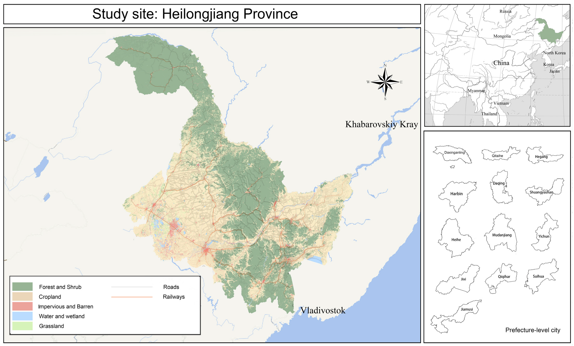
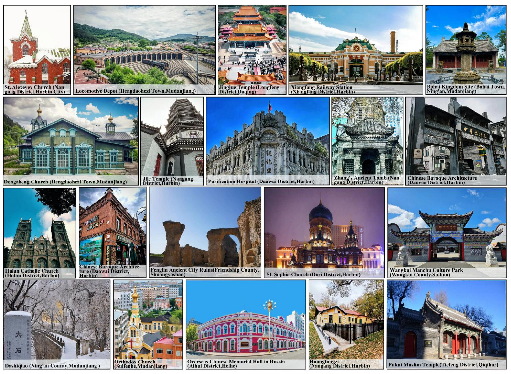
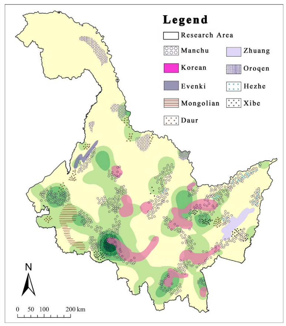
3.1. Research Area
3.2. Research Workflow
3.3. Research Methodology
3.3.1. Data Sources
3.3.2. Spatial Feature Analysis Methods
3.3.3. Corridor Suitability Analysis Methods
3.3.4. Circuit Theory (Corridor Network Construction)
3.3.5. Network Structure Analysis for Corridor Connectivity Validation
4. Experimental Results
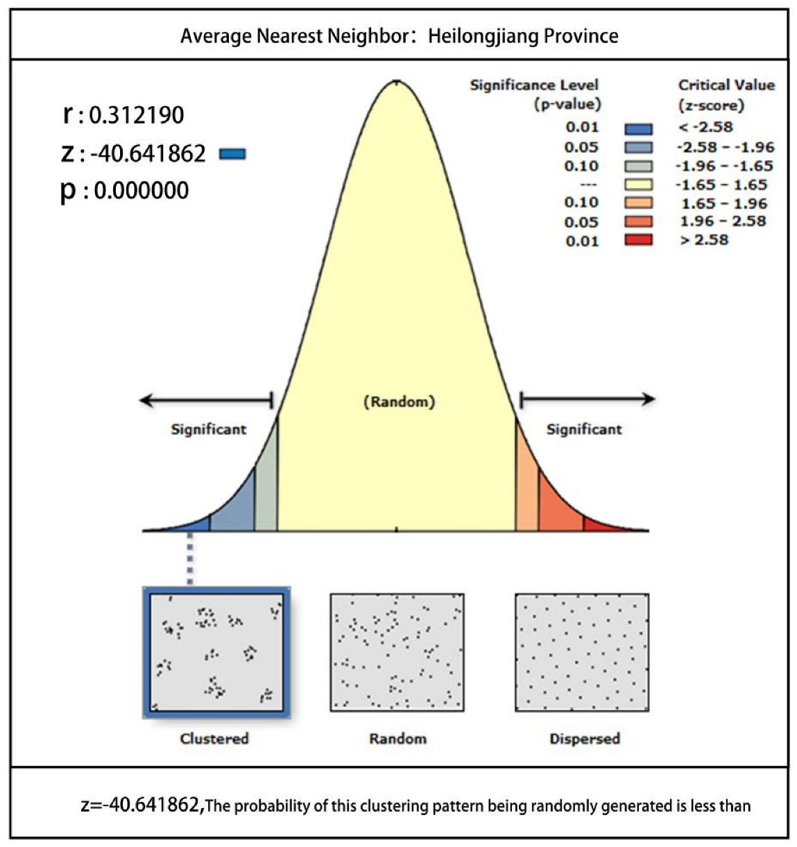
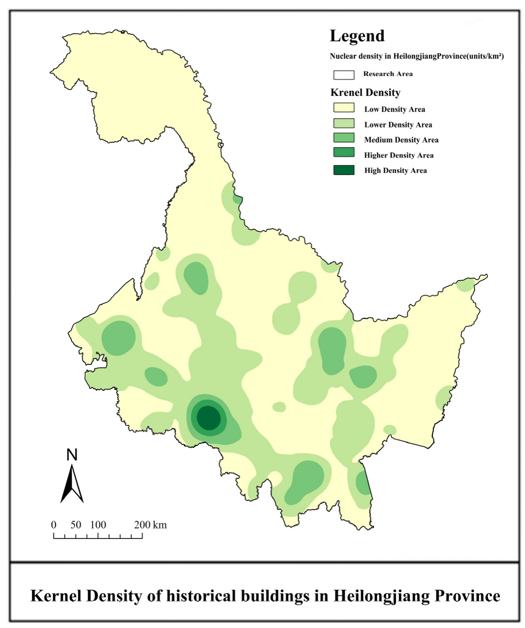
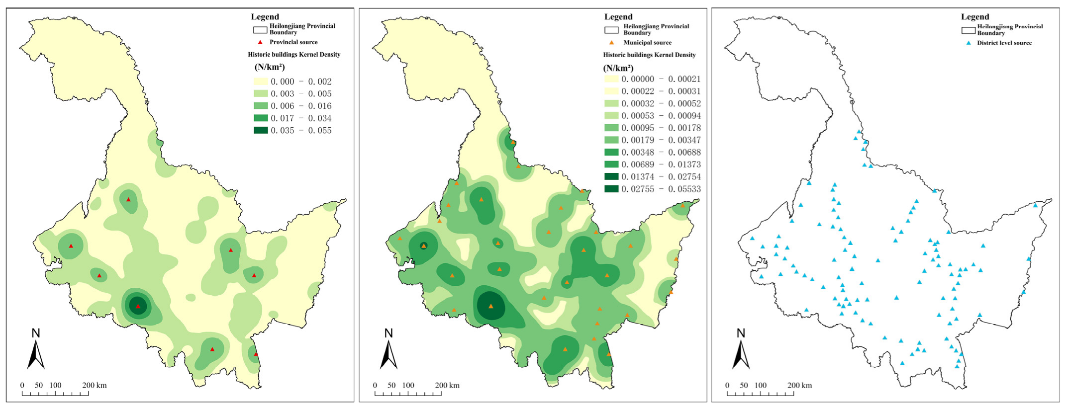
4.1. Spatial Distribution Pattern of Historical Buildings in Heilongjiang Province
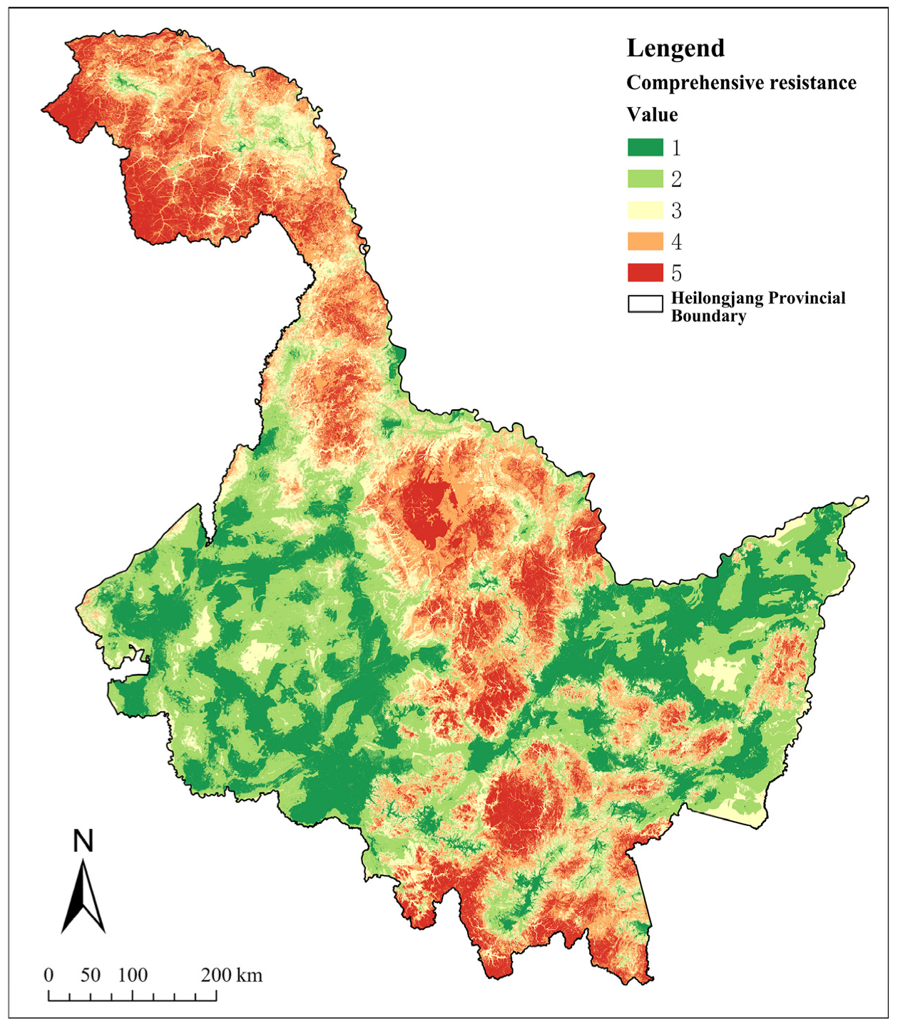
4.2. Comprehensive Resistance Cost Surface and Suitability Zoning
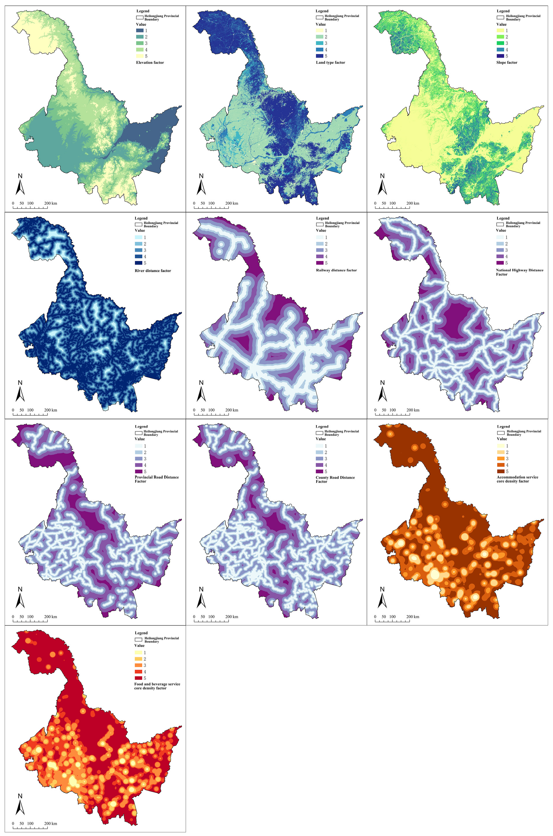
4.2.1. Analysis of the Comprehensive Resistance Surface
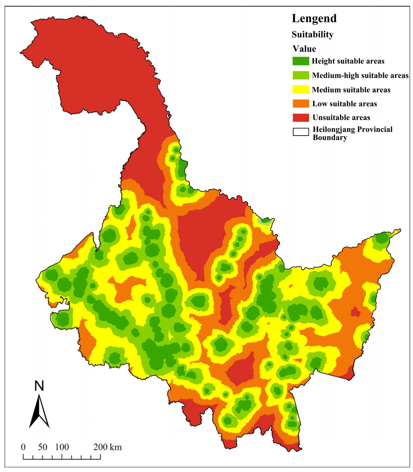
4.2.2. Suitability Zoning Results
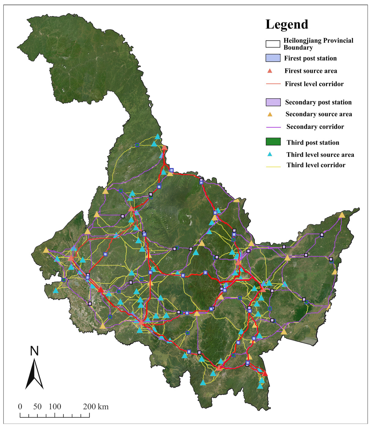
4.3. Corridor Network Generation Results
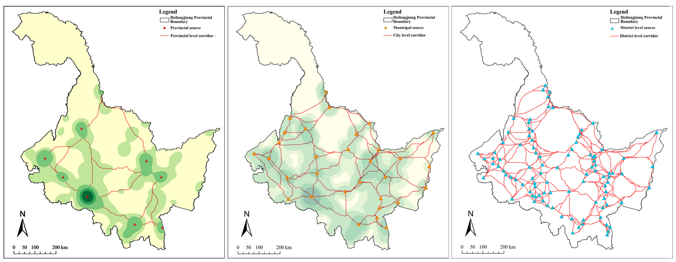
4.3.1. Source Classification
4.3.2. Corridor Generation Results
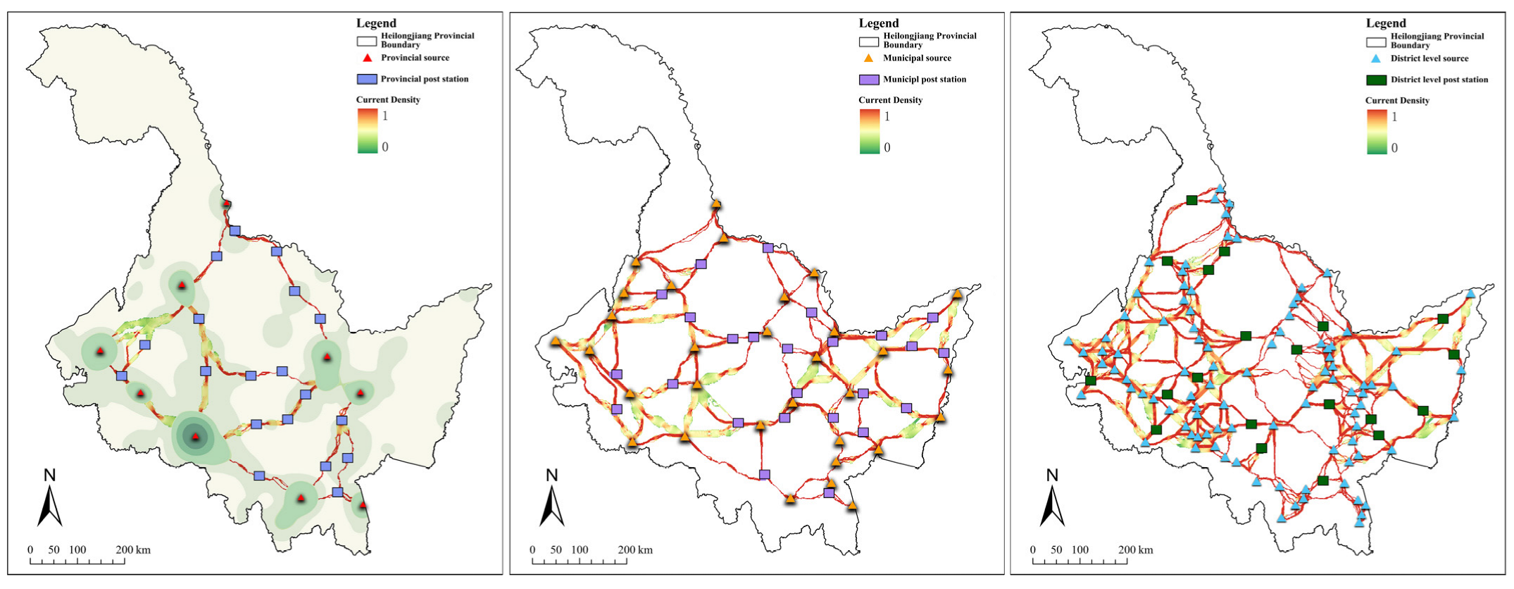
4.3.3. Identification of Key Corridor Areas and Extraction of Relay Stations
4.4. Connectivity Verification of Corridors
5. Discussion
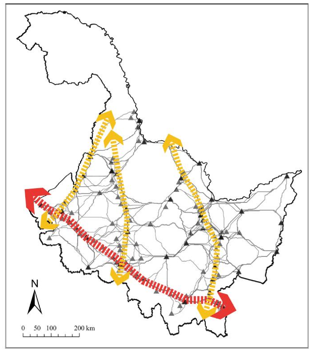
5.1. Analysis of Heilongjiang’s Architectural Heritage Corridor Pattern
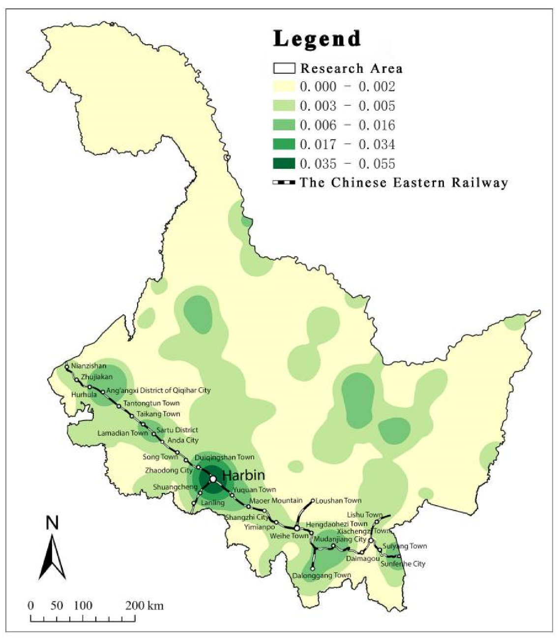
5.1.1. Potential Relationship Between Corridor Patterns and Historical Culture
5.1.2. Potential Relationship Between Heritage Corridor Patterns and Ecological Patterns
5.2. Identification of Gaps and Repair Strategies for Heilongjiang’s Heritage Corridor Network
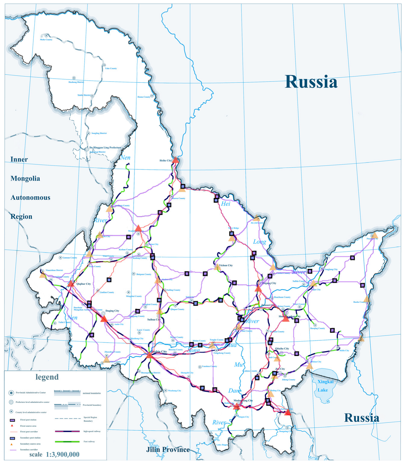
5.2.1. Gaps in Primary Corridors and Integration with High-Speed Railway Systems
5.2.2. Gaps in Secondary Corridors and Coordination with Conventional Railway Networks
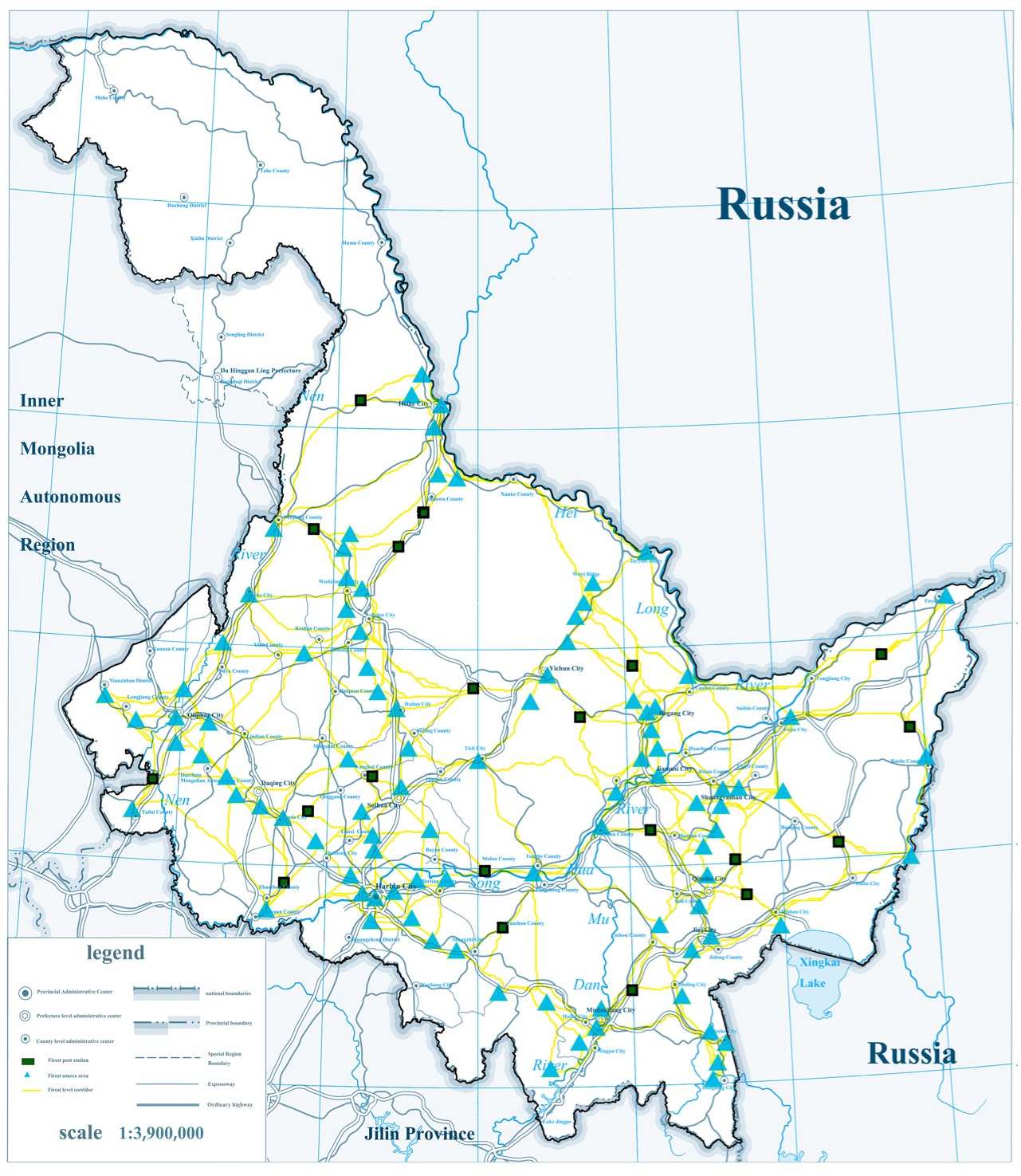
5.2.3. Gaps in Tertiary Corridors and Edge Repair Strategies with Highway Systems
5.2.4. Optimization of Relay Nodes and Coupling with Transportation Facilities
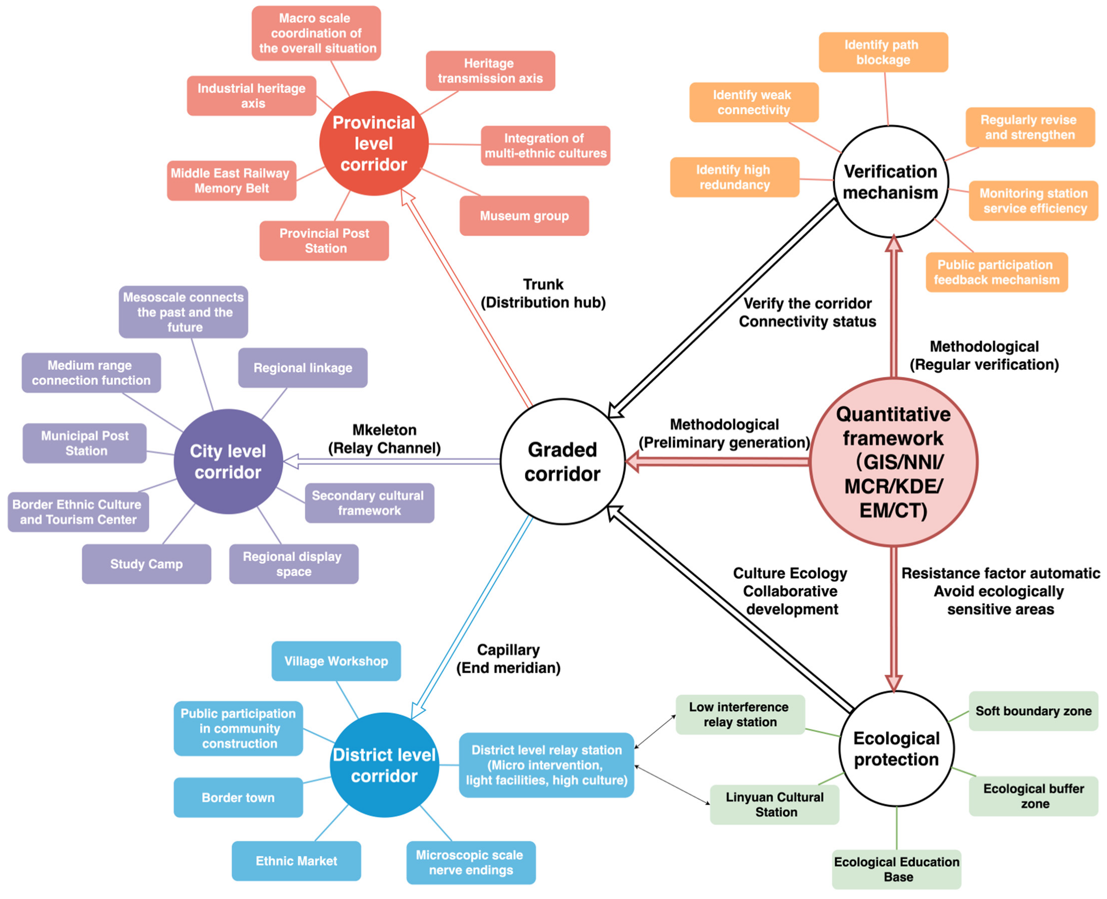
5.3. Overall Construction Strategy for Heilongjiang’s Historical Heritage Corridors
5.3.1. Hierarchical Collaboration: Establishing a Clear and Functionally Complementary Network Governance Framework
5.3.2. Ecological Synergy: Coordinated Development of Cultural Heritage Corridors and Ecological Protection
6. Conclusions
Author Contributions
Funding
Data Availability Statement
Conflicts of Interest
References
- Zhang, J.; Jiang, L.; Wang, X.; Chen, Z.; Xu, S. A Study on the Spatiotemporal Aggregation and Corridor Distribution Characteristics of Cultural Heritage: The Case of Fuzhou, China. Buildings 2024, 14, 121. [Google Scholar] [CrossRef]
- Cui, Y. Research on Big Data 3D Scanning Empowering the Protection and Inheritance of Historical Building Cultural Heritage: A Case Study of Deqing Confucian Temple. In Proceedings of the 3rd Conference on Digital Cultural Heritage, Zhengzhou, China, 11 January 2025; pp. 142–144. (In Chinese) [Google Scholar] [CrossRef]
- Lv, R.; Liu, Y.; Zhang, L.; Kong, D. Urban Historic Heritage Buffer Zone Delineation: The Case of Shedian. Herit. Sci. 2022, 10, 64. [Google Scholar] [CrossRef]
- Zhou, X.; Tang, Y.; Su, J. Heritage Corridor Routing Method from Historic Urban Landscape and Digital Footprint Perspectives—The Case of Historical Urban Area in Nanjing, China. Landsc. Archit. Front. 2023, 11, 11–38. [Google Scholar] [CrossRef]
- Zhang, T.; Yang, Y.; Fan, X.; Ou, S. Corridors Construction and Development Strategies for Intangible Cultural Heritage: A Study about the Yangtze River Economic Belt. Sustainability 2023, 15, 13449. [Google Scholar] [CrossRef]
- Yue, F.; Li, X.; Huang, Q.; Li, D. A Framework for the Construction of a Heritage Corridor System: A Case Study of the Shu Road in China. Remote Sens. 2023, 15, 4650. [Google Scholar] [CrossRef]
- Xu, H.; Zhao, G.; Fagerholm, N.; Primdahl, J.; Plieninger, T. Participatory Mapping of Cultural Ecosystem Services for Landscape Corridor Planning: A Case Study of the Silk Roads Corridor in Zhangye, China. J. Environ. Manag. 2020, 264, 110458. [Google Scholar] [CrossRef]
- Wang, Y. Research on the Value Cognition of Cultural Heritage in the Gansu Section of the Silk Road from the Perspective of Heritage Corridor. Soc. Sci. Rev. 2021, 36, 107–115. (In Chinese) [Google Scholar]
- Chang, Y.; Zhou, C. Research on the Construction and Application Strategies of Exhibition Corridors for Historical Sites in China′s Border Areas: A Case Study of National Protected Historical Sites in Jilin Province. Archit. Cult. 2017, 226–227. (In Chinese) [Google Scholar]
- Wang, Q.; Yang, C.; Wang, J.; Tan, L. Tourism in Historic Urban Areas: Construction of Cultural Heritage Corridor Based on Minimum Cumulative Resistance and Gravity Model—A Case Study of Tianjin, China. Buildings 2024, 14, 2144. [Google Scholar] [CrossRef]
- Wang, Q.; Liu, W.; Mao, L. Spatial Evolution of Traditional Village Dwellings in Heilongjiang Province. Sustainability 2023, 15, 5330. [Google Scholar] [CrossRef]
- Yan, S.; Geng, S.; Chau, H.W.; Wang, T.; Jamei, E.; Vrcelj, Z. Adaptive Reuse of Russian-Influenced Religious Architecture in Harbin: Architectural Identity and Heritage Tourism. Heritage 2024, 7, 7115–7141. [Google Scholar] [CrossRef]
- Jin, H.; Zhao, J.; Liu, S.; Kang, J. Climate Adaptability Construction Technology of Historic Conservation Areas: The Case Study of the Chinese–Baroque Historic Conservation Area in Harbin. Sustainability 2018, 10, 3374. [Google Scholar] [CrossRef]
- Ji, X.; Shao, L. The Application of Landscape Infrastructure Approaches in the Planning of Heritage Corridor Supporting System. Procedia Eng. 2017, 198, 1123–1127. [Google Scholar] [CrossRef]
- Shen, Y.; Liu, J.; Han, J.; Wan, X. Reconstructing the Silk Road Network: Insights from Spatiotemporal Patterning of UNESCO World Heritage Sites. Land 2024, 13, 1401. [Google Scholar] [CrossRef]
- Wu, Y.; Miao, M.; Wu, Y.; Zhu, H.; Li, X.; Candeias, A. The Research on the Construction of Traditional Village Heritage Corridors in the Taihu Lake Region Based on the Current Effective Conductance (CEC) Theory. Buildings 2025, 15, 472–510. [Google Scholar] [CrossRef]
- Lee, J.A.; Chon, J.; Ahn, C. Planning Landscape Corridors in Ecological Infrastructure Using Least-Cost Path Methods Based on the Value of Ecosystem Services. Sustainability 2014, 6, 7564–7585. [Google Scholar] [CrossRef]
- Zhang, J.; Shen, H. The Impact of Urban River Corridors on Landscape Patterns Based on GIS and RS Technology. J. Shandong Agric. Univ. (Nat. Sci. Ed.) 2018, 49, 769–771. (In Chinese) [Google Scholar]
- Wang, Z.; Sun, P. Heritage Corridor: A New Approach to Heritage Conservation. Chin. Landsc. Archit. 2001, 86–89. Available online: https://www.cnki.com.cn/Article/CJFDTOTAL-ZGYL200105035.htm (accessed on 3 April 2025). (In Chinese).
- Gao, C.; Li, Y. A Review of Heritage Corridor Research in China. J. Kunming Univ. Sci. Technol. (Soc. Sci. Ed.) 2018, 18, 101–108. (In Chinese) [Google Scholar]
- Ye, H.; Yang, Z.; Xu, X. Ecological Corridors Analysis Based on MSPA and MCR Model—A Case Study of the Tomur World Natural Heritage Region. Sustainability 2020, 12, 959. [Google Scholar] [CrossRef]
- Li, X.; Zhu, R.; Shi, C.; Yang, X.; Chen, J.; Wei, K. Research on the Construction of Intangible Cultural Heritage Corridors in the Yellow River Basin Based on Geographic Information System (GIS) Technology and the Minimum Cumulative Resistance (MCR) Model. Herit. Sci. 2024, 12, 1–18. [Google Scholar] [CrossRef]
- Wang, X. Construction of the Beijing-Shenyang-Qing Cultural Heritage Corridor Based on Analytic Hierarchy Process. Master′s Thesis, Xi′an University of Architecture and Technology, Xi′an, China, 2009. (In Chinese). [Google Scholar]
- Chen, P. Construction of Landscape Evaluation System for the China Eastern Railway Corridor under the AHP Method. Shanxi Archit. 2014, 40, 32–33. (In Chinese) [Google Scholar]
- Liu, L. Holistic Conservation and Utilization of Linear Industrial Heritage along the China Eastern Railway. J. Shenyang Norm. Univ. (Soc. Sci. Ed.) 2013, 37, 24–28. (In Chinese) [Google Scholar]
- Zhou, C.; Zhou, L.; Zhang, X. Spatial Differentiation and Driving Factors of Multi-Category Intangible Cultural Heritage Projects in China. Geogr. Geo-Inf. Sci. 2023, 39, 72–80. (In Chinese) [Google Scholar]
- Yu, K.J.; Li, W.; Li, D.H.; Li, C.B.; Huang, G.; Liu, H.L. Exploring Suitability Analysis Methods for Heritage Corridors in Rapid Urbanization Areas: A Case Study of Taizhou City. Geogr. Res. 2005, 69–76, 162. (In Chinese) [Google Scholar]
- Xu, D.; Guo, X.; Watanabe, T.; Liang, K.; Kou, J.; Jiang, X. Ecological Security Pattern Construction in Rural Settlements Based on Importance and Vulnerability of Ecosystem Services: A Case Study of the Southeast Region of Chongqing, China. Sustainability 2023, 15, 7477. [Google Scholar] [CrossRef]
- Zhang, P.; Zhang, N. Quantitative Analysis of Narrative Environment in Urban Historic Districts Based on Space Syntax. Urban Dev. Stud. 2017, 24, 17–22. (In Chinese) [Google Scholar]
- Lin, F.; Zhang, X.; Ma, Z.; Zhang, Y. Spatial Structure and Corridor Construction of Intangible Cultural Heritage: A Case Study of the Ming Great Wall. Land 2022, 11, 1478. [Google Scholar] [CrossRef]
- Li, X.; Xia, H. Evaluation of Regeneration Value for Railway Heritage Corridors: A Case Study of the Beijing-Zhangjiakou Railway (Beijing Section). S. Archit. 2023, 40–51. (In Chinese) [Google Scholar] [CrossRef]
- Wang, Y.; Zeng, G. Research on the Construction of Silk Road Cultural Heritage Corridor from a Spatial Perspective. World Reg. Stud. 2022, 31, 862. (In Chinese) [Google Scholar]
- Zhang, Z.; Niu, J.; Cheng, Q.; Wang, Z. Construction of Ecological Tourism Corridors and Ecotourism Zones in the Xinyang Section of the Huaihe River Basin. J. Xinyang Norm. Univ. (Nat. Sci. Ed.) 2023, 36, 517–5222. (In Chinese) [Google Scholar]
- Ognyanova, K.; Rawlings, C.M.; Smith, J.A.; Moody, J.; McFarland, D. Network Analysis: Integrating Social Network Theory, Method, and Application with R. J. Soc. Struct. 2024, 25, 22–24. [Google Scholar]
- Chen, Y.; Dang, A.; Peng, X. Building a Cultural Heritage Corridor Based on Geodesign Theory and Methodology. J. Urban Manag. 2014, 3, 97–112. [Google Scholar] [CrossRef]
- Du, C.; Pan, D.; Liu, Q. The Construction of a Protection Network for Traditional Settlements Across Regions: A Case Study of the Chengdu–Chongqing Ancient Post Road Heritage Corridor in China. Land 2025, 14, 327. [Google Scholar] [CrossRef]
- Li, Y.; Zhang, Y. Spatial Distribution Characteristics and Influencing Factors of World Architectural Heritage Sites. Heritage 2021, 4, 164. [Google Scholar] [CrossRef]
- Jiang, L.; Cai, J. Research on the Spatial and Temporal Distribution and Evolution Characteristics of Ancient Architectural Heritage in Southeastern Zhejiang. Sustainability 2023, 15, 16618. [Google Scholar] [CrossRef]
- Wang, J.; Zhang, H.; Xie, C.; Wang, H.Y.; Tao, L.; Li, Y.T.; Huang, Y.F. Suitability Evaluation of Intangible Cultural Heritage Corridor Construction in the Grand Canal Cultural Belt Based on GIS. Acta Ecol. Sin. 2025, 1–18. (In Chinese) [Google Scholar] [CrossRef]
- Huang, Y.; Shen, S.; Hu, W.; Li, Y.; Li, G. Construction of Cultural Heritage Tourism Corridor for the Dissemination of Historical Culture: A Case Study of Typical Mountainous Multi-Ethnic Area in China. Land 2023, 12, 138. [Google Scholar] [CrossRef]
- Du, R.; Chen, J. Evaluation of Green Space Landscape Systems in the Fringe Zone of Nanjing’s Main Urban Area Based on Social Network Analysis. Chin. Landsc. Archit. 2022, 38, 68–73. (In Chinese) [Google Scholar]
- Feng, L.; Gong, Y.; Liang, Z. Integrating Cross-Regional Ecological Networks in Blue–Green Spaces: A Spatial Planning Approach for the Yangtze River Delta Demonstration Area. Sustainability 2025, 17, 4193. [Google Scholar] [CrossRef]
- McRae, B.H.; Beier, P. Circuit Theory Predicts Gene Flow in Plant and Animal Populations. Proc. Natl. Acad. Sci. USA 2007, 104, 19885–19890. [Google Scholar] [CrossRef]
- Clark, P.J.; Evans, F.C. Distance to Nearest Neighbor as a Measure of Spatial Relationships in Populations. Ecology 1954, 35, 445–453. [Google Scholar] [CrossRef]
- Rosenblatt, M. Remarks on Some Nonparametric Estimates of a Density Function. Ann. Math. Stat. 1956, 27, 832–837. [Google Scholar] [CrossRef]
- Parzen, E. On Estimation of a Probability Density Function and Mode. Ann. Math. Stat. 1962, 33, 1065–1076. [Google Scholar] [CrossRef]
- Knaapen, J.P.; Scheffer, M.; Harms, B. Estimating habitat isolation in landscape planning. Landsc. Urban Plan. 1992, 23, 1–16. [Google Scholar] [CrossRef]
- Shannon, C.E. A Mathematical Theory of Communication. Bell Syst. Tech. J. 1948, 27, 379–423. [Google Scholar] [CrossRef]
- Cui, M. Theoretical Methods and Research in Cultural Ecology. J. Yunnan Norm. Univ. (Philos. Soc. Sci. Ed.) 2012, 44, 58–64. (In Chinese) [Google Scholar]
- Li, H.; Wang, Z. Exploring the Anti-Japanese War Heritage Corridor System Based on GIS Spatial Analysis. Urban Dev. Stud. 2017, 24, 86–93. (In Chinese) [Google Scholar]
- Zhang, Q.; Ge, J. Research on the Construction of Huizhou Heritage Corridor Network from the Perspective of Cultural Ecology. Ind. Constr. 2024, 54, 20–29. [Google Scholar] [CrossRef]
- Ma, X.; Xu, X. Connectivity Optimization and Management of Ecological Conservation Red Lines at Regional Scale: A Case Study of the Yangtze River Delta. J. Nat. Resour. 2022, 37, 3088–3101. (In Chinese) [Google Scholar]
- Wei, K.; Jiang, X.; Zhu, R.; Duan, X.; Yang, J. Spatial and Temporal Distribution Characteristics of Heritage Buildings in Yangzhou and Influencing Factors and Tourism Development Strategies. Buildings 2025, 15, 1081. [Google Scholar] [CrossRef]
- Gao, H.; Wang, Y.; Zhang, H.; Huang, J.; Yue, X.; Chen, F. Spatial Distribution and Typological Classification of Heritage Buildings in Southern China. Buildings 2023, 13, 2025. [Google Scholar] [CrossRef]
- Liu, Y.; Ding, J.; Wang, H.; Du, Y. A Clustering Algorithm Based on the Detection of Density Peaks and the Interaction Degree Between Clusters. Appl. Sci. 2025, 15, 3612. [Google Scholar] [CrossRef]


| Category | Quantitative Method | Technical Features and Empirical Evaluation | Related Studies |
|---|---|---|---|
| Experience-Driven | Analytic Hierarchy Process (AHP) | Technical Features: Determines heritage value weights through expert scoring, combined with GIS kernel density analysis to identify heritage clusters. Empirical Evaluation: Highly subjective but simple to operate, suitable for early-stage planning with limited data. | (Wang, 2009): Constructing cultural heritage corridors using AHP [23]. (Chen, 2014): Hierarchical structure model for corridor landscape system construction [24]. |
| Kernel Density Analysis | Technical Features: Defines a core protection range based on experience, overlaying administrative boundaries and natural elements. Empirical Evaluation: Relies on planner experience; requires integration with other quantitative tools for dynamic optimization. | (Liu, 2013): Holistic protection and utilization of linear industrial heritage [25]. | |
| Technology-Driven | Nearest Neighbor Index | Technical Features: Measures the distribution pattern of spatial points by calculating the distance between a point and its nearest neighbor. Empirical Evaluation: Assesses the randomness of point distribution and performs statistical significance tests. | (Zhou et al., 2023): Measuring spatial clustering of intangible cultural heritage to reveal distribution characteristics [26]. |
| GIS + MCR Model (Minimum Cumulative Resistance) | Technical Features: Integrates land use, elevation, and other factors in ArcGIS to construct a resistance surface. Experts assign resistance values, and the MCR model calculates optimal paths between heritage nodes, identifying connectivity bottlenecks. Empirical Evaluation: Highly quantitative, enabling visualization of corridor suitability, but resistance parameters rely on subjective assignment. | (Yu et al., 2005): Simulating corridor suitability areas using resistance coefficients [27] (Ye et al., 2020): Identifying ecological-cultural composite corridors using the MCR model [21]. (Xu et al., 2023): Extracting ecological corridors using GIS and MCR [28]. | |
| Space Syntax Analysis | Technical Features: Quantifies accessibility and integration using space syntax to identify transportation advantages and evaluates spatial structure rationality with an axial model. Empirical Evaluation: Suitable for functional optimization of urban-scale heritage corridors but less sensitive to natural terrain. | (Zhang et al., 2017): Proposing revitalization strategies using space syntax [29]. (Lin et al., 2022): Building a suitability model for heritage corridors using space syntax and axial integration [30]. (Li et al., 2023): Evaluating accessibility and constructing a 3D coupling model for heritage corridors [31]. | |
| Kernel Density Analysis + Standard Deviation Ellipse Analysis | Technical Features: Kernel density analysis identifies heritage hotspots, while standard deviation ellipses reveal spatial distribution directions. Empirical Evaluation: Visually reveals distribution directions and morphological features but requires integration with path simulation models for deeper spatial structure analysis. | (Wang, 2022): Quantifying spatiotemporal clustering and distribution evolution of heritage points [32]. (Zhang et al., 2023): Constructing ecological tourism corridors using kernel density analysis, standard deviation ellipses, and the MCR model [33]. | |
| Interdisciplinary Integration | Circuit Theory | Technical Features: Analogizes current conduction, treating heritage nodes as “source–sink.” GIS assigns conduction coefficients to calculate effective conduction values, identifying high-resistance areas and integrating cultural (entropy weight method), ecological, and social resistance surfaces to generate comprehensive conduction maps. Empirical Evaluation: Dynamically simulates heritage element flows, overcoming limitations of static models. | (Ognyanova et al., 2024): Combining circuit theory and SNA to analyze heritage node connectivity and conduction, establishing a corridor system [34]. (Wu et al., 2025): Optimizing heritage corridor closure and connectivity using current conduction simulation [16]. |
| Geodesign Theory | Technical Features: Integrates GIS spatial analysis with planning and design, overlays natural, cultural, and administrative boundaries, and simulates tourist behavior and community interactions using ABM models. Empirical Evaluation: Achieves integrated planning and analysis but requires multi-departmental collaboration due to model complexity. | (Chen et al., 2014): Integrating GIS spatial analysis with planning and design to delineate heritage corridors [35]. | |
| Network Structure Analysis | Technical Features: Evaluates network structure based on graph theory, quantifying node connectivity and path redundancy. Empirical Evaluation: Efficiently quantifies network structure rationality, suitable for multi-scale analysis. | (Wu et al., 2025): Introducing network structure analysis to evaluate corridor structure rationality, optimize path closure, and enhance connectivity analysis adaptability and practicality [16]. |
| Item | Information Entropy Value e | Information Utility Value d | Weight Coefficient w |
|---|---|---|---|
| Elevation Classification | 0.9905 | 0.0095 | 16.90% |
| Land Classification | 0.9896 | 0.0104 | 18.53% |
| Slope | 0.9856 | 0.0144 | 25.69% |
| Accommodation Core Classification | 0.9987 | 0.0013 | 2.26% |
| Catering Core Classification | 0.9989 | 0.0011 | 1.89% |
| Water Resistance | 0.9948 | 0.0052 | 9.27% |
| Road Resistance | 0.9857 | 0.0143 | 25.47% |
| Index Name | Meaning | Mathematical Expression | Evaluation Focus |
|---|---|---|---|
| Index | Degree of Closure | Measures the number of closed loops in the network; higher values indicate greater stability. | |
| Index | Degree of Complexity | Assesses the average number of paths connected to each node in the network. | |
| Index | Degree of Connectivity | Ratio of actual connections to maximum possible connections, reflecting network accessibility. |
| Prefecture-Level City | Total Area km2 | Buildings (No.) | Historical Buildings per km2 (Average) |
|---|---|---|---|
| Harbin | 53,100 | 298 | 0.0056 |
| Daqing City | 21,204.88 | 46 | 0.0022 |
| Hegang | 14,684 | 40 | 0.0027 |
| Jixi | 22,500 | 28 | 0.0012 |
| Mudanjiang | 40,600 | 119 | 0.0029 |
| Qitaihe | 6221 | 13 | 0.0021 |
| Qiqihar | 42,469 | 116 | 0.0027 |
| Shuangyashan | 22,050 | 39 | 0.0018 |
| Suihua | 35,000 | 75 | 0.0021 |
| Yichun | 32,800 | 43 | 0.0013 |
| Jiamusi | 32,460 | 57 | 0.0018 |
| Heihe | 68,726 | 80 | 0.0012 |
| Typology | Resistance Factor | Weight | Resistance Value | ||||
|---|---|---|---|---|---|---|---|
| 1 | 2 | 3 | 4 | 5 | |||
| Environment | Elevation (m) | 12.9 | 0–100 | 100–200 | 200–300 | 300–500 | >500 |
| Land use | 12.7 | Construction land and unused land | Cultivated land | Grassland and shrubs | Water bodies and wetland | Woodland | |
| Slope (°) | 24.3 | 0–3 | 3–5 | 5–10 | 10–20 | >20 | |
| Economy | Distance from river (km2) | 7.05 | >20 | 10–20 | 5–10 | 1–5 | 0–1 |
| Railway distance (km2) | 8.54 | 0–10 | 10–20 | 20–40 | 40–60 | >60 | |
| National highway distance (km2) | 7.21 | 0–5 | 5–10 | 10–20 | 20–40 | >40 | |
| Provincial highway distance (km2) | 10.2 | 0–5 | 5–10 | 10–20 | 20–40 | >40 | |
| County road distance (km2) | 6.51 | 0–5 | 5–10 | 10–20 | 20–40 | >40 | |
| Public service | Food and beverages (n/km2) | 5.97 | >2 | 0.5–2 | 0.05–0.5 | 0.01–0.05 | 0–0.001 |
| Accommodation service (n/km2) | 4.6 | >0.5 | 0.1–0.5 | 0.05–0.1 | 0.01–0.05 | 0–0.001 | |
| Level | Road Classification | Number of Corridors | Average Minimum Path Length | Average Current Flow Betweenness Centrality |
|---|---|---|---|---|
| 1 | County Road | 307 | 100,936.04234527687 | −1.0 |
| 2 | Municipal Road | 81 | 175,527.9012345679 | |
| 3 | Provincial Road | 13 | 211,725.53846153847 | −1.0 |
| Index | Edges | Nodes | Actual Number of Loops/Maximum Possible | α Value | β Value | Maximum Possible Number of Connections | γ Value |
|---|---|---|---|---|---|---|---|
| 1 | 401 | 148 | 252/288 | 0.872852 | |||
| 2 | 401 | 148 | 5.418918 | ||||
| 3 | 401 | 148 | 10,878 | 0.915525 |
| Level | Corresponding Source Area Level | Current Density Level | Path Length Characteristics | Main Functional Positioning |
|---|---|---|---|---|
| First level | Between provincial -level source areas | High (main channel) | Medium to long distance, laminar | Regional cultural main corridor |
| Second level | Between municipal -level source areas | Medium density | Medium to short distance, supplementary line | Regional secondary connecting corridor |
| Third level | District-level source areas and micro-nodes | Low (branch channel) | Short distance, terminal node | Micro-cultural extension passage |
Disclaimer/Publisher’s Note: The statements, opinions and data contained in all publications are solely those of the individual author(s) and contributor(s) and not of MDPI and/or the editor(s). MDPI and/or the editor(s) disclaim responsibility for any injury to people or property resulting from any ideas, methods, instructions or products referred to in the content. |
© 2025 by the authors. Licensee MDPI, Basel, Switzerland. This article is an open access article distributed under the terms and conditions of the Creative Commons Attribution (CC BY) license (https://creativecommons.org/licenses/by/4.0/).
Share and Cite
Feng, L.; Sun, J.; Zhai, T.; Miao, M.; Yu, G. Planning for Cultural Connectivity: Modeling and Strategic Use of Architectural Heritage Corridors in Heilongjiang Province, China. Buildings 2025, 15, 1970. https://doi.org/10.3390/buildings15121970
Feng L, Sun J, Zhai T, Miao M, Yu G. Planning for Cultural Connectivity: Modeling and Strategic Use of Architectural Heritage Corridors in Heilongjiang Province, China. Buildings. 2025; 15(12):1970. https://doi.org/10.3390/buildings15121970
Chicago/Turabian StyleFeng, Lyuhang, Jiawei Sun, Tongtong Zhai, Mingrui Miao, and Guanchao Yu. 2025. "Planning for Cultural Connectivity: Modeling and Strategic Use of Architectural Heritage Corridors in Heilongjiang Province, China" Buildings 15, no. 12: 1970. https://doi.org/10.3390/buildings15121970
APA StyleFeng, L., Sun, J., Zhai, T., Miao, M., & Yu, G. (2025). Planning for Cultural Connectivity: Modeling and Strategic Use of Architectural Heritage Corridors in Heilongjiang Province, China. Buildings, 15(12), 1970. https://doi.org/10.3390/buildings15121970