
Development of an Open Government Data (OGD) Evaluation Framework for BIM

Abstract
1. Introduction
2. Terminology
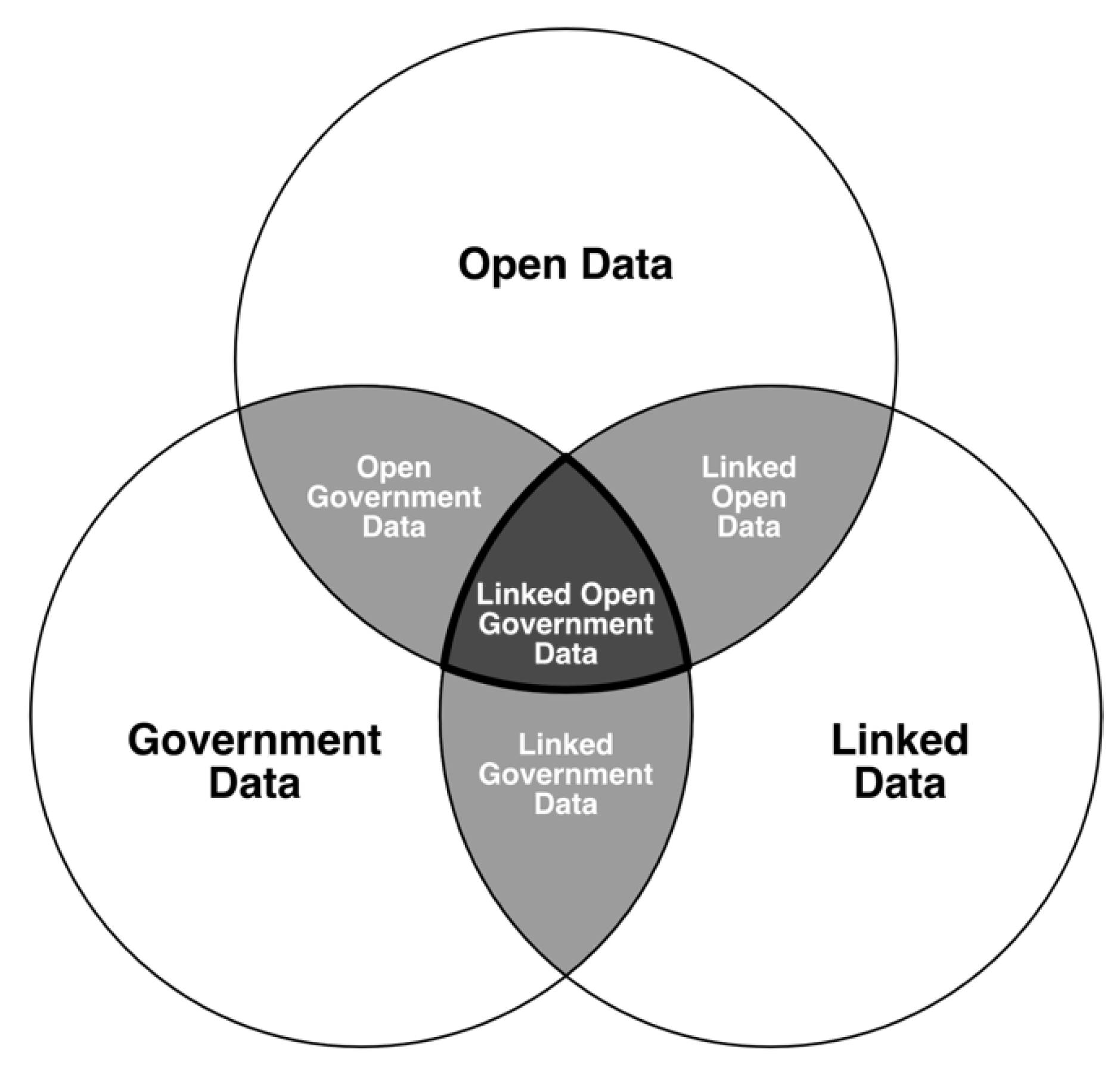
2.1. Open Data
2.2. Open Government Data
2.3. Linked Data
2.4. Linked Open Data and Linked OGD
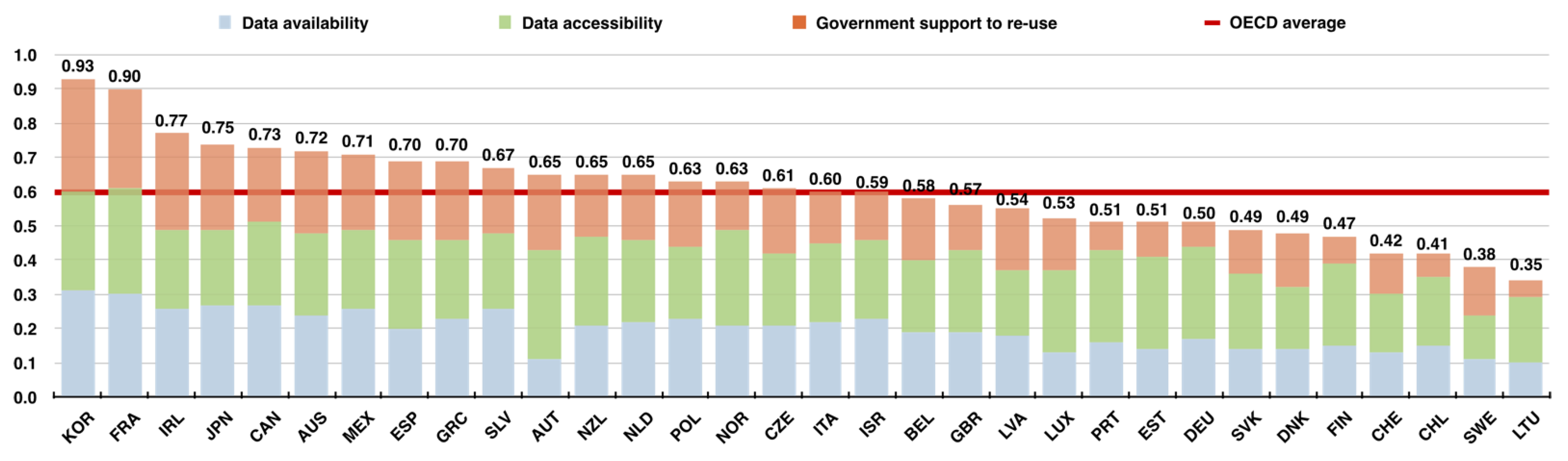
2.5. Open Data Initiatives
3. Evaluation Framework for OGD in the AEC Industry
- Analyzing the status of data utilization in the work environment of BIM-based design and the effectiveness of the construction process to identify the possibility of utilization and importance of data provided by public institutions (Section 3.1);
- Analyzing the principles of various open government initiative evaluation frameworks from the perspectives of data creation, distribution, and utilization (Section 3.2);
- Classifying the evaluation metrics of OGD appliable to the AEC industry, followed by defining detailed levels of the evaluation metrics from the primitive level to the progressive level (Section 3.3);
- Finally, defining the integrated framework levels that combine each evaluation metric to evaluate the environment of OGD utilization for data-centric BIM (Section 3.4).
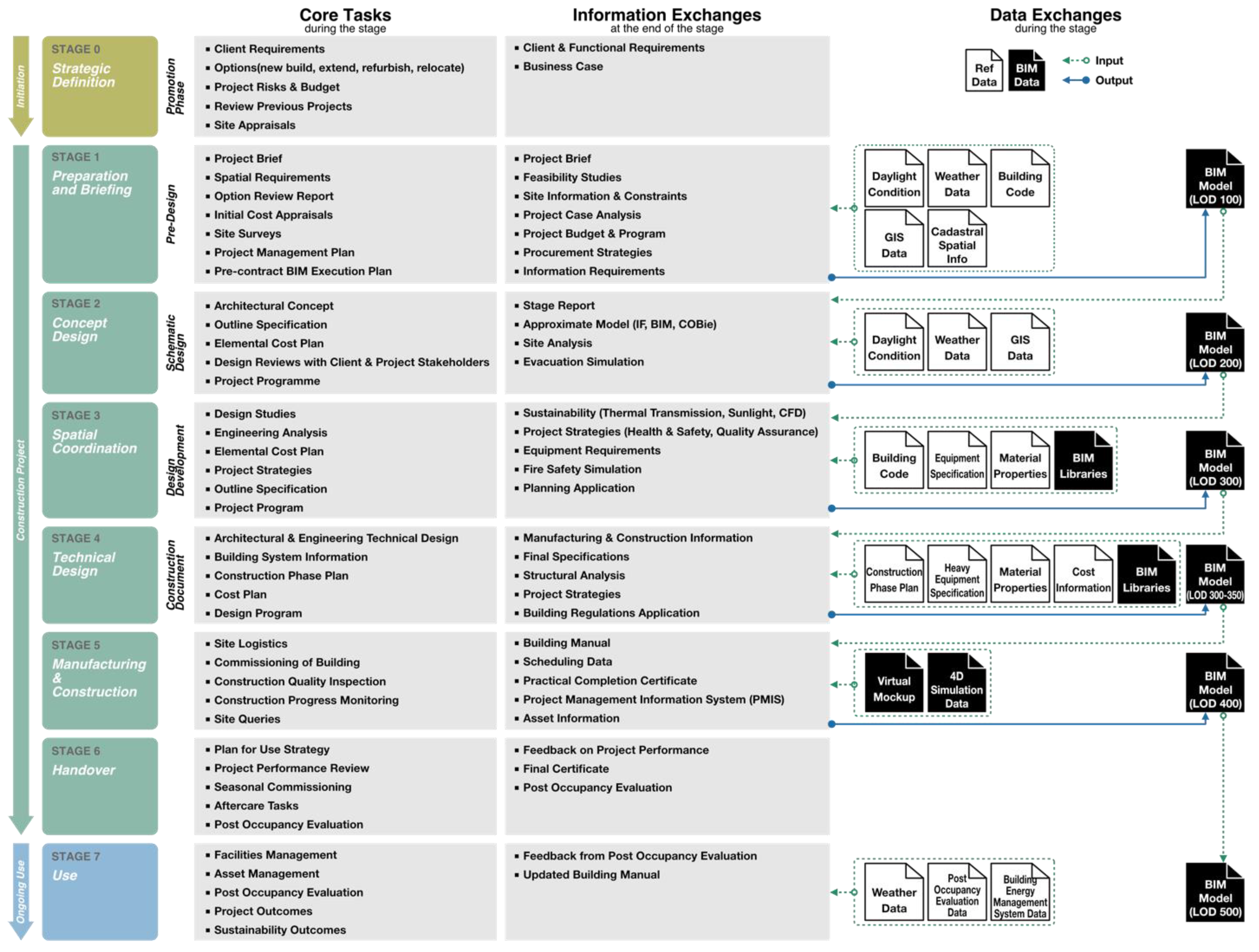
3.1. Data-Driven Process for BIM-Based Architectural Design
3.2. Evaluation Metric Definition: Method
3.2.1. Open Government Evaluation Frameworks
3.2.2. Derived Metrics from the Open Government Evaluation Frameworks
3.3. Evaluation Metrics for OGD in the AEC Industry: Results
3.3.1. Data Interoperability
3.3.2. Data Accessibility
- Level 1 (data list-up): Data consumers can directly find and download the relevant data that they need among available data that are simply listed like posts in message boards on data portals. Only a simple search function is supported based on the basic information of the data, such as titles, publishers, or abstracts, which may result in the user being overloaded to go through all the results to potentially identify the useful and relevant datasets [104]. In particular, this can be a major challenge in a situation in which similar data are provided from various decentralized data sources [105,106].
- Level 2 (data collection): The published data are provided in a form so that they can be filtered as a collection and dataset based on low-level metadata records including basic information. Because the metadata records in this step are not configured in a standardized manner by data type or each institution that provides the data, there can be a heterogeneity issue in terms of semantics, standards, and schema. Thus, like Level 1, much effort is required by data users to select useful data.
- Level 3 (catalog using metadata): Datasets mapped into a standardized metadata schema enable machine-readable representations of the predominant data catalogs [107]. It can achieve better searchability and, subsequently, better accessibility for catalogs differing widely in scope, terminology, and structure. The use of extensible mark-up language (XML) or resource description framework (RDF) as a data format is preferrable, as they are highly descriptive data formats that help data consumers to clearly understand the data. A further aspect of versioning would also be recommended to capture how a dataset evolves over time [101,108].
- Level 4 (open APIs): Datasets are accessible through a content management system, such as Representational State Transfer Application Programming Interface (RESTful API), which allows agents to interact with data portals and easily retrieve the metadata in a structured format (e.g., as JavaScript Object Notation (JSON) data) with the respective dataset from the backend [38]. This allows for flexibility in provisioning data as well as full-scale data processing operations at the underlying database level [109]. Furthermore, it provides better accessibility to the raw datasets for further operations such as data analytics techniques, including dashboards and predictive modeling.
- Level 5 (cloud computing for Data as a Service, DaaS, or Analytics as a Service, AaaS): Data providers or portals provide an extra service with exploration or analysis tools running on a cloud infrastructure, which enable a data consumer to easily look through the published raw data in a visual manner using graphs or knowledge maps. Data consumers can extract valuable insights, usually on demand, regardless of the location and affiliation, from statistical models, and analysis can be conducted against the existing structured data or simulated future data. These analytics and data reports can also be downloaded in a machine-readable format, such as .csv or tab delimited .txt files, as another raw dataset for further usage.
3.3.3. Data Reliability
- Level 1 (update is not available): There is no additional verification process for the accuracy or completeness of data once they are produced; thus, data management or tracking becomes impossible. There is a high possibility of unreliable and inaccurate data because data that need to be periodically changed such as statistical and weather data cannot be updated.
- Level 2 (separate updated dataset is provided): When the information of a dataset is revised or updated or new contents are added, a new dataset is provided separate from the existing file. Therefore, data users must manually update through research when needed because connectivity with the existing dataset is not guaranteed, and it is impossible to track changes. Thus, there exists a data-compatibility risk.
- Level 3 (with broken continuity): When changes are made to the datasets, prompts and notifications are expected, and details about the updated contents are provided. However, to apply the updated dataset, it must be manually updated, which is only possible by overwriting the entire existing dataset. Therefore, if additional work is performed using an existing dataset, continuity of the work details cannot be guaranteed, and the work details may disappear in some cases.
- Level 4 (with half automation): Similar to Level 3, details regarding the updated contents are provided; however, only the changes in the dataset can be partially updated. Therefore, although there is the advantage that existing work details are maintained, the update history cannot be managed. Hence, the data user should take care when deciding whether to update the data, and the data cannot be restored once updated.
- Level 5 (with full automation): If data are newly updated, they can be automatically updated based on the importance of updates defined by the data provider or data user, and the details regarding data revisions and the update history are managed by version. Therefore, the update can easily be reverted back if anything goes wrong or newly updated data are not necessary. Moreover, higher data usability can be expected because data can be managed and analyzed by version.
3.3.4. Data License
- Level 1: Data can be copied and distributed in any format in an unadapted form only, for noncommercial purposes only, and only so long as attribution is given to the data provider.
- Level 2: Data can be copied and distributed in any format in an unadapted form only, for commercial use, and only so long as attribution is given to the data provider.
- Level 3: Data can be distributed, remixed, adapted, and built upon in any format for noncommercial purposes only, and only so long as attribution is given to the data provider.
- Level 4: Data can be distributed, remixed, adapted, and built upon in any format for commercial use, so long as attribution is given to the data provider.
- Level 5: Data can be distributed, remixed, adapted, and built upon in any format with no conditions.
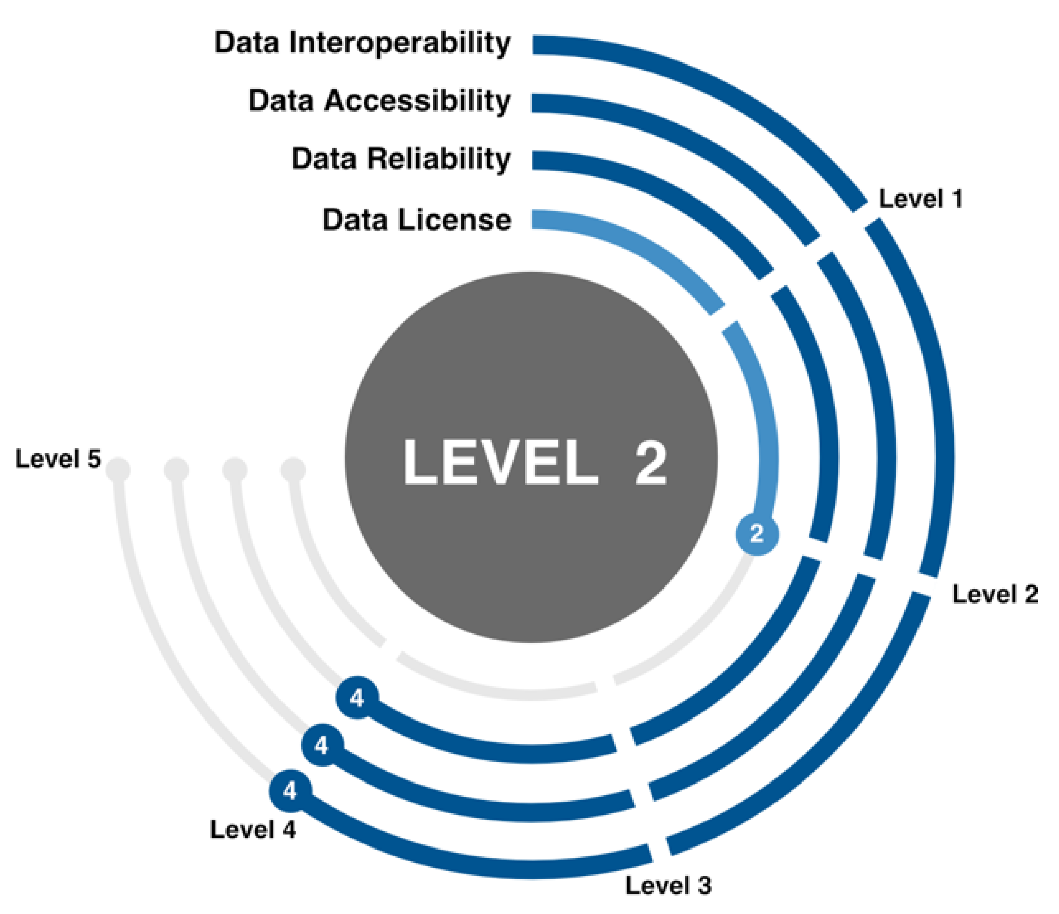
3.4. Framework Levels Based on the Four Evaluation Metrics
- Level 1 (batch processing): Batch processing, a general data processing method, is an efficient way of processing a large volume of static data collected over a certain period [113]. It manually updates data depending on the user’s need or data provision method periodically, such as daily or monthly, when the metadata of OGD are changed or updated. One example is the case of geographical or material data, which are updated only when needed by batch processing when real-time interconnection is not necessary depending on the purpose of data processing or there is a large computer load for data processing. Data update on this level does not guarantee continuity of the existing work because updates are performed by overwriting the entire dataset with a new dataset. Hence, more attention is required for data management. When data must be processed and applied in real time such as energy simulation or construction site management, the real-time processing method should be considered rather than batch processing, which processes data by batch at regular intervals.
- Level 2 (real-time processing): Real-time (streaming) data processing involves the continuous collection and automatic processing and analysis of OGDs whenever there are changes in the metadata of OGD utilized by a user or the contents are updated. To enable real-time processing of OGD, the prerequisites such as the provided data format, method of provision, and update method must be met. For example, the data must be built in a non-proprietary open format (interoperability level 2) at a minimum. Moreover, the data must be provided by RESTful API (accessibility level 4) so that only changed parts of the data can be partially updates in real time (reliability level 4). In this way, the continuity of existing work must be guaranteed. Several applications, such as post occupancy evaluation, energy supply, and fault detections in a built environment, require real-time processing of data streams gathered from heterogeneous sources and networks [114]. In the case of a license, batch processing allows the utilization and redistribution or original data as they are; however, real-time processing also enables secondary works such as data remix and adaptation (license level 3 or higher).
- Level 3 (hybrid processing): Hybrid models can deal with application domains where data processing can benefit from both the volume and processing time of static (previous behavior) as well as dynamic (current status) data. This is a hybrid method in which users can directly update the entire dataset to a new dataset when necessary, and it is also possible to automatically update only the changed part of data in real time. In particular, unlike real-time processing, data users can systematically manage data because work history can be managed based on the updated version (reliability level 5). This also has the advantage of securing data reliability and building a flexible work system. Like real-time processing, the data license also allows secondary works such as data remix and adaptations (license level 3 or higher).

| Framework Level | Definition |
|---|---|
 | Level 1: Batch processing |
| The newly changed data are periodically and manually updated (accessibility level 1 or 2) when a large volume of static data in the form of structured data (at least interoperability level 2) are changed. The continuity of work is not guaranteed because the entire data are overwritten (reliability level 2). The original form of data is used as is (license level 1 or 2). | |
 | Level 2: Real-time processing |
| Only the changed part of the existing information among data in the form of structured data (at least interoperability level 2) can be updated (at least accessibility level 3, but preferably level 4). Continuity of work is guaranteed because only the changed part of data can be automatically updated (at least reliability level 4). The method of showing data in their original form (license level 1 or 2) and the method of newly remixed, adapted and built upon in any format (license level 3 or higher) are both possible. | |
 | Level 3: Hybrid processing |
| A hybrid method that allows both batch processing, which can update the entire dataset in the form of structured data (at least interoperability level 2) with a new dataset and real-time processing that can update only the changed part of data (accessibility level 4). The highest reliability and flexibility are provided in terms of data management because the updated versions can be managed (reliability level 5). The method of showing data in their original form (license level 1 or 2) and the method of newly remixed, adapted and built upon in any format (license level 3 or higher) are both possible. |
4. Application of the Evaluation Framework: Case Study
4.1. Data Interoperability
4.2. Data Accessibility
4.3. Data Reliability
4.4. Data License
5. Discussion and Limitations
6. Conclusions
- Making data available as linked structured data in non-proprietary open format to ensure high interoperability that enables interconnection or combination between datasets;
- Making data available through open APIs and/or DaaS or AaaS for high levels of accessibility and expandability;
- Making data more reliable by supporting updates that enable tracking and managing data change details;
- Making data available to create an environment where free data movement and reprocessing are possible by granting permission to use data in fully open manners.
- Batch processing: This method manually updates the entire structured dataset when needed. It does not guarantee the continuity of work.
- Real-time processing: Continuity of work is guaranteed and data reprocessing is possible because an automatic partial update of structured dataset is possible when required.
- Hybrid processing: A mixture of the batch processing method, which updates all data as needed, and the real-time processing method, which can only update the changes. This method can manage various data versions.
Author Contributions
Funding
Institutional Review Board Statement
Informed Consent Statement
Data Availability Statement
Conflicts of Interest
References
- Kassen, M. A promising phenomenon of open data: A case study of the Chicago open data project. Gov. Inf. Q. 2013, 30, 508–513. [Google Scholar] [CrossRef]
- Janssen, K. The influence of the PSI directive on open government data: An overview of recent developments. Gov. Inf. Q. 2011, 28, 446–456. [Google Scholar] [CrossRef]
- Borzacchiello, M.T.; Max, C. The impact on innovation of open access to spatial environmental information: A research strategy. Int. J. Technol. Manag. 2012, 60, 114–129. [Google Scholar] [CrossRef]
- Bertot, J.C.; Jaeger, P.T.; Grimes, J.M. Using ICTs to create a culture of transparency: E-government and social media as openness and anti-corruption tools for societies. Gov. Inf. Q. 2010, 27, 264–271. [Google Scholar] [CrossRef]
- Huijboom, N.; Van den Broek, T. Open data: An international comparison of strategies. Eur. J. ePractice 2020, 12, 4–16. [Google Scholar]
- Open Government Initiative. Open Goverement Policy. Available online: https://obamawhitehouse.archives.gov/open (accessed on 17 September 2020).
- Open Data Directive. Open Data and the Re-use of Public Sector Information. Available online: https://eur-lex.europa.eu/eli/dir/2019/1024/oj (accessed on 17 September 2020).
- Jaeger, P.T.; Bertot, J.C. Transparency and technological change: Ensuring equal and sustained public access to government information. Gov. Inf. Q. 2010, 27, 371–376. [Google Scholar] [CrossRef]
- Cameron, D. Letter to Government Departments on Opening Up Data. Available online: https://webarchive.nationalarchives.gov.uk/20100908143020/; http://www.number10.gov.uk/news/statements-and-articles/2010/05/letter-to-government-departments-on-opening-up-data-51204; (accessed on 17 September 2020).
- buildingSMART. Industry Foundation Classes (IFC)—An Introduction. Available online: https://technical.buildingsmart.org/standards/ifc (accessed on 27 November 2021).
- National BIM Standard United States. National BIM Standard–United States Version 3. Available online: https://www.nationalbimstandard.org/files/NBIMS-US_V3_4.2_COBie.pdf (accessed on 30 November 2021).
- Rezgui, Y.; Beach, T.; Rana, O. A Governance Approach for BIM Management across Lifecycle and Supply Chains using Mixed-modes of Information Delivery. J. Civ. Eng. Manag. 2013, 19, 239–258. [Google Scholar] [CrossRef]
- Lee, C.-M.; Kuo, W.-L.; Tung, T.-J.; Huang, B.-K.; Hsu, S.-H. Government Open Data and Sensing Data Integration Framework for Smart Construction Site Management. In Proceedings of the 36th ISARC, Banff, AB, Canada, 21–24 May 2019; pp. 1261–1267. [Google Scholar]
- McGinley, T.P.; Vestergaard, T.; Jeong, C.-H.; Pind, F. An OpenBIM workflow to support collaboration between Acoustic Engineers and Architects. In Proceedings of the 8th International Buildings Physics Conference 2021, Copenhagen, Denmark, 25–27 August 2021; pp. 1–9. [Google Scholar]
- Wang, R.Y.; Strong, D.M. Beyond accuracy: What data quality means to data consumers. J. Manag. Inf. Syst. 1996, 12, 5–33. [Google Scholar] [CrossRef]
- Wand, Y.; Wang, R.Y. Anchoring data quality dimensions in ontological foundations. Commun. ACM 1996, 39, 86–95. [Google Scholar] [CrossRef]
- Redman, T.C. Data Quality for the Information Age; Artech House: London, UK, 1996. [Google Scholar]
- Bovee, M.; Srivastava, R.P.; Mak, B. A conceptual framework and belief-function approach to assessing overall information quality. Int. J. Intell. Syst. 2003, 18, 51–74. [Google Scholar] [CrossRef]
- Naumann, F. Quality-Driven Query Answering for Integrated Information Systems; Lecture Notes in Computer Science; Goos, G., Hartmanis, J., Leeuwen, J.V., Eds.; Springer: Berlin/Heidelberg, Germany, 2002; Volume 2261. [Google Scholar]
- Batini, C.; Scannapieco, M. Data Quality: Concepts, Methodologies and Techniques; Springer: Berlin/Heidelberg, Germany, 2006. [Google Scholar]
- Jarke, M.; Lenzerini, M.; Vassiliou, Y.; Vassiliadis, P. Fundamentals of Data Warehouses; Springer: Berlin/Heidelberg, Germany, 2003. [Google Scholar]
- Open Knowledge Foundation. Open Definition 2.1. Available online: https://opendefinition.org/od/2.1/en/ (accessed on 10 July 2021).
- The White House. Open Government Directive. Available online: https://obamawhitehouse.archives.gov/open/documents/open-government-directive (accessed on 10 July 2021).
- Kučera, J.; Chlapek, D.; Nečaský, M. Open Government Data Catalogs: Current Approaches and Quality Perspective. In Technology-Enabled Innovation for Democracy, Government and Governance. EGOVIS/EDEM 2013; Lecture Notes in Computer Science; Kő, A., Leitner, C., Leitold, H., Prosser, A., Eds.; Springer: Berlin/Heidelberg, Germany, 2013; Volume 8061, pp. 152–166. [Google Scholar]
- Wang, H.-J.; Lo, J. Adoption of open government data among government agencies. Gov. Inf. Q. 2016, 33, 80–88. [Google Scholar] [CrossRef]
- Bakıcı, T.; Almirall, E.; Wareham, J. A Smart City Initiative: The Case of Barcelona. J. Knowl. Econ. 2013, 4, 135–148. [Google Scholar] [CrossRef]
- De Rosnay, M.D.; Janssen, K. Legal and Institutional Challenges for Opening Data across Public Sectors: Towards Common Policy Solutions. J. Theor. Appl. Electron. Commer. Res. 2014, 9, 1–14. [Google Scholar] [CrossRef]
- Lin, C.S.; Yang, H.-C. Data Quality Assessment on Taiwan’s Open Data Sites. In Multidisciplinary Social Networks Research. MISNC 2014; Communications in Computer and Information Science; Wang, L.S.-L., June, J.J., Lee, C.-H., Okuhara, K., Yang, H.-C., Eds.; Springer: Berlin/Heidelberg, Germany, 2014; Volume 473. [Google Scholar]
- Parycek, P.; Höchtl, J.; Ginner, M. Open Government Data Implementation Evaluation. J. Theor. Appl. Electron. Commer. Res. 2014, 9, 80–99. [Google Scholar] [CrossRef]
- Styrin, E.; Dmitrieva, N.; Zhulin, A. Openness evaluation framework for public agencies. In Proceedings of the 7th International Conference on Theory and Practice of Electronic Governance, New York, NY, USA, 22–25 October 2013; pp. 370–371. [Google Scholar]
- Open Government Partnership. Available online: https://www.opengovpartnership.org/members/ (accessed on 11 July 2021).
- Bizer, C.; Heath, T.; Berners-Lee, T. Linked Data–The Story so far. Int. J. Semant. Web Inf. Syst. 2009, 5, 1–22. [Google Scholar] [CrossRef]
- Klyne, G.; Carroll, J.J.; McBride, B. RDF 1.1 Concepts and Abstract Syntax–W3C Recommendation. Available online: https://www.w3.org/TR/rdf11-concepts/ (accessed on 11 July 2021).
- 5 Star Open Data. Available online: https://5stardata.info (accessed on 11 July 2021).
- Geiger, C.P.; Lucke, J.V. Open Government and (Linked) (Open) (Goverment) (Data). Ejournal Edemocracy Open Gov. 2012, 4, 265–278. [Google Scholar] [CrossRef]
- Lebo, T.; Erickson, J.S.; Ding, L.; Graves, A.; Williams, G.T.; DiFranzo, D.; Li, X.; Michaelis, J.; Zheng, J.G.; Flores, J.; et al. Producing and Using Linked Open Government Data in the TWC LOGD Portal. In Linking Government Data; Wood, D., Ed.; Springer: New York, NY, USA, 2011; pp. 51–72. [Google Scholar]
- Heath, T. How will we interact with the web of data? IEEE Internet Comput. 2008, 12, 88–91. [Google Scholar] [CrossRef][Green Version]
- Neumaier, S.; Umbrich, J.; Polleres, A. Automated Quality Assessment of Metadata across Open Data Portals. J. Data Inf. Qual. 2016, 8, 1–29. [Google Scholar] [CrossRef]
- Shadbolt, N.; O’Hara, K.; Berners-Lee, T.; Gibbins, N.; Glaser, H.; Hall, W.; Schraefel, M.C. Linked Open Government Data: Lessons from Data.gov.uk. IEEE Intell. Syst. 2012, 27, 16–24. [Google Scholar] [CrossRef]
- Kalampokis, E.; Tambouris, E.; Tarabanis, K. A classification scheme for open government data: Towards linking decentralised data. Int. J. Web Eng. Technol. 2011, 6, 266–285. [Google Scholar] [CrossRef]
- Bizer, C.; Lehmann, J.; Kobilarov, G.; Auer, S.; Becker, C.; Cyganiak, R.; Hellmann, S. Dbpedia–A crystallization point for the Web of Data. Web Semant. Sci. Serv. Agents World Wide Web 2009, 7, 154–165. [Google Scholar] [CrossRef]
- Höchtl, J.; Reichstädter, P. Linked Open Data–A Means for Public Sector Information Management. In Electronic Government and the Information Systems Perspective. EGOVIS 2011; Lecture Notes in Computer Science; Andersen, K.N., Francesconi, E., Grönlund, A., Van Engers, T.M., Eds.; Springer: Berlin/Heidelberg, Germany, 2011; Volume 6866, pp. 330–343. [Google Scholar]
- Hitz-Gamper, B.S.; Neumann, O.; Stürmer, M. Balancing control, usability and visibility of linked open government data to create public value. Int. J. Public Sect. Manag. 2019, 32, 451–466. [Google Scholar] [CrossRef]
- Villazón-Terrazas, B.; Vilches-Blázquez, L.M.; Corcho, O.; Gómez-Pérez, A. Methodological guidelines for publishing government linked data. In Linking Government Data; Wood, D., Ed.; Springer: New York, NY, USA, 2011; pp. 27–49. [Google Scholar]
- OECD. Open, Useful and Re-Usable Data (OURdata) Index: 2019; OECD Publishing: Paris, France, 2020. [Google Scholar]
- Data.gov.au. Available online: https://data.gov.au (accessed on 14 June 2021).
- Kim, W. On three major holes in data warehousing today. J. Object Technol. 2002, 1, 39–47. [Google Scholar] [CrossRef]
- May, I.; Pynn, C.; Hill, P. Arup’s Digital Future: The Path to BIM. In Building Information Modeling: Technology Foundations and Industry Practice; Borrmann, A., König, M., Koch, C., Beetz, J., Eds.; Springer: Cham, Switzerland, 2015; pp. 509–534. [Google Scholar]
- JB Knowledge. 2017 Construction Technology Report; JB Knowledge: Bryan, TX, USA, 2017. [Google Scholar]
- RIBA. RIBA Plan of Work 2020 Overview; RIBA: London, UK, 2020. [Google Scholar]
- Kim, I.; Park, J.; Park, C.; Jung, J.; Choo, S. BIM in Architecture: Design and Engineering; Kimoondang: Seoul, Korea, 2013. [Google Scholar]
- Chin, S. Storytelling Building Information Modeling; CIR: Seoul, Korea, 2020. [Google Scholar]
- BIMForum. Level of Development (LOD) Specification for Building Information Models; BIMForum: Washington, DC, USA, 2021. [Google Scholar]
- Sacks, R.; Eastman, C.; Lee, G.; Teicholz, P. BIM Handbook: A Guide to Building Information Modeling for Owners, Designers, Engineers, Contractors, and Facility Managers, 3rd ed.; John Wiley & Sons P&T: Hoboken, NJ, USA, 2018. [Google Scholar]
- Kim, H. A BIM Design Support System in Open BIM Platform. Master’s Thesis, Hanyang University, Seoul, Korea, 2021. [Google Scholar]
- Breiner, S.; Subrahmanian, E.; Sriram, R.D. Modeling the Internet of Things: A foundational approach. In Proceedings of the Seventh International Workshop on the Web of Things (WoT ‘16), Stuttgart, Germany, 7 November 2016; pp. 38–41. [Google Scholar]
- Abdelrahman, M.M.; Chong, A.; Miller, C. Personal thermal comfort models using digital twins: Preference prediction with BIM-extracted spatial–temporal proximity data from Build2Vec. Build. Environ. 2022, 207, 108532. [Google Scholar] [CrossRef]
- Miller, C.; Abdelrahman, M.; Chong, A.; Biljecki, F.; Quintana, M.; Frei, M.; Chew, M.; Wong, D. The Internet-of-Buildings (IoB)—Digital twin convergence of wearable and IoT data with GIS/BIM. J. Phys. Conf. Ser. 2021, 2042, 012041. [Google Scholar] [CrossRef]
- Isikdag, U.; Underwood, J.; Aouad, G. An investigation into the applicability of building information models in geospatial environment in support of site selection and fire response management processes. Adv. Eng. Inform. 2008, 22, 504–519. [Google Scholar] [CrossRef]
- Sergi, D.M.; Li, J. Applications of GIS-Enhanced Networks of Engineering Information. Appl. Mech. Mater. 2013, 444–445, 1672–1679. [Google Scholar] [CrossRef]
- Hjelseth, E.; Thiis, T.K. Use of BIM and GIS to enable climatic adaptations of buildings. In Proceedings of the 7th European Conference on Product and Process Modelling: eWork and eBusiness in Architecture, Engineering and Construction, Sophia Antipolis, France, 10–12 September 2008; pp. 409–418. [Google Scholar]
- Kari, S.; Lellei, L.; Gyulai, A.; Sik, A.; Riedel, M.M. BIM to GIS and GIS to BIM. In Proceedings of the 2016 CAADence in Architecture: Back to Command, Budapest, Hungary, 16–17 June 2016. [Google Scholar]
- Niu, S.; Pan, W.; Zhao, Y. A BIM-GIS integrated web-based visualization system for low energy building design. Procedia Eng. 2015, 121, 2184–2192. [Google Scholar] [CrossRef]
- Irizarry, J.; Karan, E.P.; Jalaei, F. Integrating BIM and GIS to improve the visual monitoring of construction supply chain management. Autom. Constr. 2013, 31, 241–254. [Google Scholar] [CrossRef]
- Göçer, Ö.; Hua, Y.; Göçer, K. Completing the missing link in building design process: Enhancing post-occupancy evaluation method for effective feedback for building performance. Build. Environ. 2015, 89, 14–27. [Google Scholar] [CrossRef]
- Manfren, M.; Nastasi, B.; Groppi, D.; Garcia, D.A. Open data and energy analytics–An analysis of essential information for energy system planning, design and operation. Energy 2020, 213, 118803. [Google Scholar] [CrossRef]
- Kang, T.W.; Hong, C.H. A study on software architecture for effective BIM/GIS-based facility management data integration. Autom. Constr. 2015, 54, 25–38. [Google Scholar] [CrossRef]
- Wang, H.; Pan, Y.; Luo, X. Integration of BIM and GIS in sustainable built environment: A review and bibliometric analysis. Autom. Constr. 2019, 103, 41–52. [Google Scholar] [CrossRef]
- Amirebrahimi, S.; Rajabifard, A.; Mendis, P.; Ngo, T. A data model for integrating GIS and BIM for assessment and 3D visualisation of flood damage to building. In Proceedings of the CEUR Workshop Proceedings, Brisbane, Australia, 10–12 March 2015; pp. 78–89. [Google Scholar]
- Karimi, H.A.; Akinci, B. CAD and GIS Integration, 1st ed.; Taylor and Francis Group (CRC Press): Boca Raton, FL, USA, 2009. [Google Scholar]
- Guyo, E.; Hartmann, T.; Ungureanu, L. Interoperability between BIM and GIS through open data standards: An overview of current literature. In Proceedings of the 9th Linked Data in Architecture and Construction Workshop–LDAC2021, Luxembourg, 11–13 October 2021; pp. 115–126. [Google Scholar]
- El-Mekawy, M.; Östman, A.; Hijazi, I. A Unified Building Model for 3D Urban GIS. ISPRS Int. J. Geo-Inf. 2012, 1, 120–145. [Google Scholar] [CrossRef]
- Vilgertshofer, S.; Amann, J.; Willenborg, B.; Borrmann, A. Linking BIM and GIS Models in Infrastructure by Example of IFC and CityGML. In Proceedings of the ASCE International Workshop on Computing in Civil Engineering 2017, Seattle, WA, USA, 25–27 June 2017; pp. 133–140. [Google Scholar]
- Vancauwenberghe, G.; Valečkaitė, K.; Loenen, B.v.; Donker, F.W. Assessing the Openness of Spatial Data Infrastructures (SDI): Towards a Map of Open SDI. Int. J. Spat. Data Infrastruct. Res. 2018, 13, 88–100. [Google Scholar]
- Coetzee, S.; Ivánová, I.; Mitasova, H.; Brovelli, M.A. Open Geospatial Software and Data: A Review of the Current State and A Perspective into the Future. ISPRS Int. J. Geo-Inf. 2020, 9, 90. [Google Scholar] [CrossRef]
- Quarati, A.; Martino, M.D.; Rosim, S. Geospatial Open Data Usage and Metadata Quality. ISPRS Int. J. Geo-Inf. 2021, 10, 30. [Google Scholar] [CrossRef]
- European Commission. The Copernicus Programme. Available online: https://www.copernicus.eu/en/about-copernicus (accessed on 20 December 2021).
- ESA (European Space Agency). Thematic Exploitation Platform (TEP). Available online: https://www.un-spider.org/links-and-resources/data-sources/thematic-exploitation-platform-tep-esa (accessed on 20 December 2021).
- The Open Data Cube (ODC). Available online: https://www.opendatacube.org (accessed on 20 December 2021).
- Manfren, M.; Mastasi, B.; Tronchin, L.; Groppi, D.; Garcia, D.A. Techno-economic analysis and energy modelling as a key enablers for smart energy services and technologies in buildings. Renew. Sustain. Energy Rev. 2021, 150, 111490. [Google Scholar] [CrossRef]
- Zhu, J.; Wright, G.; Wang, J.; Wang, X. A Critical Review of the Integration of Geographic Information System and Building Information Modelling at the Data Level. ISPRS Int. J. Geo-Inf. 2018, 7, 66. [Google Scholar] [CrossRef]
- Herle, S.; Becker, R.; Wollenberg, R.; Blankenbach, J. GIM and BIM. How to Obtain Interoperability Between Geospatial and Building Information Modelling? PFG-J. Photogramm. Remote Sens. Geoinf. Sci. 2020, 88, 33–42. [Google Scholar] [CrossRef]
- Wand, Y.; Weber, R. On the deep structure of information systems. Inf. Syst. J. 1995, 5, 203–223. [Google Scholar] [CrossRef]
- Van Ooijen, C.; Ubaldi, B.; Welby, B. A data-driven public sector: Enabling the strategic use of data for productive, inclusive and trustworthy governance. OECD Work. Pap. Public Gov. 2019, 33, 1–59. [Google Scholar] [CrossRef]
- OECD. Data-Driven Innovation: Big Data for Growth and Well-Being; OECD Publishing: Paris, France, 2015. [Google Scholar]
- European Parliament and Council. Directive (EU) 2019/1024 of 26 June 2019 on open data and the re-use of public sector information. Off. J. Eur. Union 2019, L 172, 56–83. [Google Scholar]
- European Commission. Open data. Available online: https://digital-strategy.ec.europa.eu/en/policies/open-data (accessed on 10 July 2021).
- European Parliament and Council. Directive 2003/98/EC of 17 November 2003 on the re-use of public sector information. Off. J. Eur. Union 2003, L 345, 90–96. [Google Scholar]
- OpenGovData. The Annotated 8 Principles of Open Government Data. Available online: https://opengovdata.org (accessed on 19 July 2021).
- Cabinet Office. G8 Open Data Charter and Technical Annex. Available online: https://www.gov.uk/government/publications/open-data-charter/g8-open-data-charter-and-technical-annex (accessed on 4 July 2021).
- Open Data Charter. International Open Data Charter. Available online: https://opendatacharter.net/principles/ (accessed on 4 July 2021).
- Wall, S.V.D.; Węcel, K.; Ermilov, I.; Janev, V.; Milošević, U.; Wainwright, M. Lifting Open Data Portals to the Data Web. In Linked Open Data–Creating Knowledge Out of Interlinked Data; Lecture Notes in Computer Science; Auer, S., Bryl, V., Tramp, S., Eds.; Springer: Cham, Switzerland, 2014; Volume 8661, pp. 175–195. [Google Scholar]
- Liu, Q.; Bai, Q.; Ding, L.; Pho, H.; Chen, Y.; Kloppers, C.; McGuinness, D.L.; Lemon, D.; De Souza, P.; Fitch, P.; et al. Linking Australian Government Data for Sustainability Science—A Case Study. In Linking Government Data; Wood, D., Ed.; Springer: New York, NY, USA, 2011; pp. 181–204. [Google Scholar]
- Marienfeld, F.; Schieferdecker, I.; Lapi, E.; Tcholtchev, N. Metadata aggregation at GovData.de: An experience report. In Proceedings of the 9th International Symposium on Open Collaboration, New York, NY, USA, 5–7 August 2013; pp. 1–5. [Google Scholar]
- Arcelus, J. Framework for useful transparency websites for citizens. In Proceedings of the 6th International Conference on Theory and Practice of Electronic Governance, New York, NY, USA, 22–25 October 2012; pp. 83–86. [Google Scholar]
- Bogdanović-Dinić, S.; Veljković, N.; Stoimenov, L. How Open Are Public Government Data? An Assessment of Seven Open Data Portals. In Measuring E-Government Efficiency. Public Administration and Information Technology; Rodríguez-Bolívar, M.P., Ed.; Springer: New York, NY, USA, 2014; Volume 5, pp. 25–44. [Google Scholar]
- Lourenço, R.P. Open Government Portals Assessment: A Transparency for Accountability Perspective. In Electronic Government. EGOV 2013; Lecture Notes in Computer Science; Wimmer, M.A., Janssen, M., Scholl, H.J., Eds.; Springer: Berlin/Heidelberg, Germany, 2013; Volume 8074, pp. 62–74. [Google Scholar]
- Sandoval-Almazan, R.; Gil-Garcia, J.R. Towards an Evaluation Model for Open Government: A Preliminary Proposal. In Electronic Government. EGOV 2014; Lecture Notes in Computer Science; Janssen, M., Scholl, H.J., Wimmer, M.A., Bannister, F., Eds.; Springer: Berlin/Heidelberg, Germany, 2014; Volume 8653, pp. 47–58. [Google Scholar]
- Veljković, N.; Bogdanović-Dinić, S.; Stoimenov, L. Benchmarking open government: An open data perspective. Gov. Inf. Q. 2014, 31, 278–290. [Google Scholar] [CrossRef]
- Martin, S.; Foulonneau, M.; Turki, S. 1–5 Stars: Metadata on the Openness Level of Open Data Sets in Europe. In Metadata and Semantics Research. MTSR 2013; Communications in Computer and Information Science; Garoufallou, E., Greenberg, J., Eds.; Springer: Cham, Switzerland, 2013; Volume 390, pp. 234–245. [Google Scholar]
- Attard, J.; Orlandi, F.; Scerri, S.; Auer, S. A systematic review of open government data initiatives. Gov. Inf. Q. 2015, 32, 399–418. [Google Scholar] [CrossRef]
- Shadbolt, N.; O’Hara, K.; Salvadores, M.; Alani, H. eGovernment. In Handbook of Semantic Web Technologies; Domingue, J., Fensel, D., Hendler, J.A., Eds.; Springer: Berlin/Heidelberg, Germany, 2011; pp. 849–910. [Google Scholar]
- Hogan, A.; Harth, A.; Passant, A.; Decker, S.; Polleres, A. Weaving the Pedantic Web. In Proceedings of the 3rd International Workshop on Linked Data on the Web (LDOW2010), Raleigh, NC, USA, 27 April 2010; pp. 1–10. [Google Scholar]
- Zuiderwijk, A.; Janssen, M. The negative effects of open government data–Investigating the dark side of open data. In Proceedings of the 15th Annual International Conference on Digital Government Research, Aguascalientes, Mexico, 18–21 June 2014; pp. 147–152. [Google Scholar]
- Conradie, P.; Choenni, S. Exploring process barriers to release public sector information in local government. In Proceedings of the 6th International Conference on Theory and Practice of Electronic Governance, Albany, NY, USA, 22–25 October 2012; pp. 5–13. [Google Scholar]
- Zuiderwijk, A.; Janssen, M. Barriers and Development Directions for the Publication and Usage of Open Data: A Socio-Technical View. In Open Government. Public Administration and Information Technology; Gascó-Hernández, M., Ed.; Springer: New York, NY, USA, 2014; Volume 4, pp. 115–135. [Google Scholar]
- Maali, F.; Cyganiak, R.; Peristeras, V. Enabling Interoperability of Government Data Catalogues. In Electronic Government. EGOV 2010; Lecture Notes in Computer Science; Wimmer, M.A., Chappelet, J.-L., Janssen, M., Scholl, H.J., Eds.; Springer: Berlin/Heidelberg, Germany, 2010; Volume 6228, pp. 339–350. [Google Scholar]
- Carroll, J.J.; Bizer, C.; Hayes, P.; Stickler, P. Named graphs, provenance and trust. In Proceedings of the 14th International Conference on World Wide Web, Chiba, Japan, 10–14 May 2005; pp. 613–622. [Google Scholar]
- Zuiderwijk, A.; Jeffery, K.; Janssen, M. The Potential of Metadata for Linked Open Data and its Value for Users and Publishers. eJournal eDemocracy Open Gov. 2012, 4, 222–244. [Google Scholar] [CrossRef]
- Thurston, A.C. Trustworthy Records and Open Data. J. Community Inform. 2012, 8, 3047. [Google Scholar] [CrossRef]
- Vetrò, A.; Canova, L.; Torchiano, M.; Minotas, C.O.; Iemma, R.; Morando, F. Open data quality measurement framework: Definition and application to Open Government Data. Gov. Inf. Q. 2016, 33, 325–337. [Google Scholar] [CrossRef]
- Creative Commons License. Available online: https://creativecommons.org/licenses/ (accessed on 16 November 2021).
- Casado, R.; Younas, M. Emerging trends and technologies in big data processing. Concurr. Comput. Pract. Exp. 2015, 27, 2078–2091. [Google Scholar] [CrossRef]
- Barlow, M. Real-Time Big Data Analytics: Emerging Architecture; O’Reilly Media, Inc.: Sebastopol, CA, USA, 2013. [Google Scholar]
- Park, S.-H.; Kim, E. Middleware for Translating Urban GIS Information for Building a Design Society Via General BIM Tools. J. Asian Archit. Build. Eng. 2016, 15, 447–454. [Google Scholar] [CrossRef]
- buildingSMART Korea. The Final Report of Building Design Standards and Infrastructure Construction based on Open BIM (15AUDPC067817-03); buildingSMART Korea: Seoul, Korea, 2017. [Google Scholar]


| Level | Descriptions |
|---|---|
| * | Datasets available on the Web in any format under an open license |
| ** | Datasets available as structured data |
| *** | Datasets available in a non-proprietary open format, e.g., CSV |
| **** | Uniform Resource Identifier (URIs) provided to denote the datasets |
| ***** | Datasets linked to other data to provide context |
| Principles | Description | |
|---|---|---|
| Public Sector Information Directive [88] | Available formats | Data must be available in any pre-existing format or language through electronic means. |
| Principles governing charging | Where charges are made, the total income from supplying and allowing re-use of data shall not exceed the cost of producing and publishing the data. | |
| Transparency | Public sector bodies should pre-establish any applicable conditions and the standard charges for the re-use of data. | |
| Licenses | Public sector bodies may allow for the re-use of data without conditions or may impose conditions. | |
| Practical arrangements | Public sector bodies should facilitate the search for data available for re-use, where available through asset lists or portal sites. | |
| Non-discrimination | Any applicable conditions for the re-use of data shall be non-discriminatory for comparable categories of re-use. | |
| Prohibition of exclusive arrangements | The re-use of data shall be open to the public without granting any exclusive rights. | |
| Open Knowledge Foundation [22] | Open license or status | Data must be in the public domain or provided under an open license. |
| Access | Data must be provided as a whole with a reasonable one-time reproduction cost and be downloadable via the Internet without charge. | |
| Machine readability | Data must be easily accessed and modified in a form readily processable by a computer. | |
| Open format | Data must be provided in an open format which can be fully processed with at least one free/open-source software tool. | |
| 30 Open Government Advocates [89] | Completeness | Data should be released to the public as complete as possible with the explanations at the greatest possible level of detail, except to the extent necessary to comply with privacy laws |
| Primacy | Data should be published with the highest possible level of granularity, not in aggregate or modified forms. | |
| Timeliness | Data should be published as quickly as necessary to preserve the value of data. | |
| Accessibility | Data must be available to the widest range of users for the widest range of purposes. | |
| Machine readability | Data must be properly encoded to allow automated processing | |
| Non-discrimination | Data must be available to anyone, with no requirement of registration. | |
| Non-proprietariness | Data must be available in a format over which no processing program has exclusive control. | |
| License-free | Data must not be subject to any copyright, patent, trademark, or trade secret regulation. | |
| G8 Open Data Charter [90] | Open data by default | All government data must be published openly by default, while recognizing national and international legislation in regard to intellectual property and personally identifiable and sensitive information. |
| Quality and quantity | Data must be released as high-quality open data, fully described, and as early as possible at the finest level of granularity available. | |
| Useable by all | Data must be available in open formats to all people to obtain and re-use it, free of charge, without bureaucratic or administrative barriers. | |
| Releasing data for improved governance | The release of open data should be transparent about data collection, standards, and publishing processes to strengthen democratic institutions. | |
| Releasing data for innovation | Open data in machine-readable formats should encourage individuals and civil society organizations to stimulate creativity and innovation. | |
| Open Data Charter [91] | Open by default | Data must be created for governments and public, without compromising the right to privacy |
| Timely and comprehensive | Data must be published quickly and in a comprehensive manner. | |
| Accessibly and usable | Data must be machine-readable and free of charge under an open license. | |
| Comparable and interoperable | Data must be in commonly agreed standards. | |
| For improved governance & citizen engagement | Data should be transparent to improve public services and civil engagement. | |
| For inclusive development and innovation | Data should help spur inclusive economic development. |
| Metrics | |
|---|---|
| Intrinsic view (capture, value) | Data-related |
| completeness, primacy, quality, and quantity | |
| System-related | |
| open format, available format, non-proprietariness, for inclusive development and innovation | |
| Operational view (maintenance, delivery) | Data-related |
| open format, available format, non-proprietariness, machine readability | |
| System-related | |
| transparency, licenses, practical arrangements, non-discrimination, prohibition of exclusive arrangements, timeliness and comprehensiveness |
| Categories | Descriptions | Metrics |
|---|---|---|
| Interoperability | The level of availability of data and the degree to which heterogeneous datasets can be linked or combined with each other | Open format |
| Available format | ||
| Non-proprietariness | ||
| Accessibility | The level of accessibility of data, the degree to which data are present, obtainable, and collected | Machine-readability |
| Practical arrangements | ||
| Non-discrimination | ||
| Reliability | The level of data reliability and accuracy by providing context and achieving traceability of datasets | Timeliness and comprehensiveness |
| License | The extent to which data can be copied, distributed, edited, remixed, and built upon | Transparency |
| Licenses | ||
| Prohibition of exclusives arrangements |
| Metric | Level | Description |
|---|---|---|
| Interoperability | Level 1 | Data published in any format under an open license (OL) |
| Level 2 | Data published as structured data (OL/RE) | |
| Level 3 | Data published in a non-proprietary open format (OL/RE/OF) | |
| Level 4 | Data published with URIs (OL/RE/OF/URI) | |
| Level 5 | Data published as linked data to other data to provide context (OL/RE/OF/URI/LD) | |
| Accessibility | Level 1 | Datasets published as a list, simply providing download and search capabilities |
| Level 2 | Datasets from different sources categorized into a set of collections based on the metadata | |
| Level 3 | Datasets mapped into standardized data catalogs based on machine-readable metadata schema, such as XML or RDF | |
| Level 4 | Datasets accessible through RESTful API based on the formalized metadata from the backend | |
| Level 5 | Cloud computing service as Data as a Service (DaaS) or Analytics as a Service (AaaS), providing an extra service of data exploration or analysis based on the datasets | |
| Reliability | Level 1 | Data once produced cannot be managed or traced through additional updates. |
| Level 2 | A new dataset is provided for revised or added information, separate from the existing dataset. | |
| Level 3 | New updates are notified, but the continuity of work cannot be guaranteed because the existing file is overwritten when data are updated (manual). | |
| Level 4 | New updates are notified, and the continuity of work can be guaranteed because only the changed parts are updated (automatic). However, updated versions cannot be managed and data recovery is impossible. | |
| Level 5 | New updates are notified, the details are provided, and partial updates (automatic) and version management are possible. High flexibility and usability of data management are provided. | |
| License | Level 1 | Data can be copied and distributed in any format in an unadapted form only, for noncommercial purposes only, and only so long as attribution is given to the data provider |
| Level 2 | Data can be copied and distributed in any format in an unadapted form only, for commercial use, and only so long as attribution is given to the data provider | |
| Level 3 | Data can be distributed, remixed, adapted, and built upon in any format for noncommercial purposes only, and only so long as attribution is given to the data provider | |
| Level 4 | Data can be distributed, remixed, adapted, and built upon in any format for commercial use, so long as attribution is given to the data provider | |
| Level 5 | Data can be distributed, remixed, adapted, and built upon in any format without any conditions |
Publisher’s Note: MDPI stays neutral with regard to jurisdictional claims in published maps and institutional affiliations. |
© 2022 by the authors. Licensee MDPI, Basel, Switzerland. This article is an open access article distributed under the terms and conditions of the Creative Commons Attribution (CC BY) license (https://creativecommons.org/licenses/by/4.0/).
Share and Cite
Park, J.J.; Kim, E.; Jun, H.J. Development of an Open Government Data (OGD) Evaluation Framework for BIM. Buildings 2022, 12, 490. https://doi.org/10.3390/buildings12040490
Park JJ, Kim E, Jun HJ. Development of an Open Government Data (OGD) Evaluation Framework for BIM. Buildings. 2022; 12(4):490. https://doi.org/10.3390/buildings12040490
Chicago/Turabian StylePark, Jong Jin, Eonyong Kim, and Han Jong Jun. 2022. "Development of an Open Government Data (OGD) Evaluation Framework for BIM" Buildings 12, no. 4: 490. https://doi.org/10.3390/buildings12040490
APA StylePark, J. J., Kim, E., & Jun, H. J. (2022). Development of an Open Government Data (OGD) Evaluation Framework for BIM. Buildings, 12(4), 490. https://doi.org/10.3390/buildings12040490