1. Introduction
Calcretes are near-surface terrestrial calcium carbonate deposits [
1]. They commonly occur as powdery to semi-consolidated accumulations of aragonite or calcite and other secondary calcium carbonate precipitates within unconsolidated materials such as gravel, sand, silt, and soil [
2]. Calcrete and dolocrete are particularly prominent as products of pedogenic and diagenetic processes developing under semi-arid and arid climatic conditions [
1,
3,
4,
5,
6,
7].
Calcretes are widely used as palaeoenvironmental indicators and may provide important information on climate fluctuations, surface stability and tectonic activity in continental depositional environments [
1,
3,
8,
9].
Geochemical data obtained from calcretes may provide valuable information on paleoclimatic variations on a regional scale as well as records of rainy and dry periods on a local and regional scale [
10,
11]. Previous studies have shown that Ca, Mg and Si become enriched in soils during periods of evaporation and depleted during wetter periods [
3,
6]. Additionally, the reddish to yellowish brown coloration, high calcification in paleosols and the preservation of rhizoliths and lime nodules were interpreted as being formed under arid to semi-arid climatic conditions [
1,
12,
13].
Terrestrial carbonates, particularly calcretes and dolocretes, are widely recognized as important archives of tectonic, paleoclimatic, and paleoenvironmental evolution in continental basins. In Türkiye, previous studies have investigated calcretes as indicators of Quaternary paleoclimate and pedogenic processes [
10,
11,
12,
14,
15], whereas other studies have focused on their mineralogical, geochemical, and isotopic characteristics [
16,
17,
18,
19]. In addition, several authors have examined the relationships between terrestrial carbonates, tectonic activity, and sedimentary evolution in different continental basins [
20,
21,
22,
23,
24,
25,
26].
Geochemical and isotopic data obtained from calcretes have been used in revealing meteoric environmental conditions on a local and regional scales. These data may also provide important clues about the geochemical characteristics of surface water, groundwater, and the surrounding bedrock [
5,
9,
27,
28,
29].
Konya Fault Zone consists of several normal dip-slip faults passing through the Konya settlement and has the potential to generate an earthquake having a magnitude of six [
30].
The formation of terrestrial carbonates is primarily controlled by pedogenic processes operating under semi-arid to arid climatic conditions. However, local geological and geomorphological factors, including tectonically controlled basin evolution, may indirectly influence the environments in which these carbonates develop. Active fault systems can affect basin morphology, alluvial fan development, fracture permeability, and groundwater distribution, thereby creating favorable conditions for soil development and pedogenic carbonate accumulation. In this context, the Konya Fault Zone is considered to have influenced the geomorphological and hydrogeological setting of the study area, whereas the precipitation of calcrete and dolocrete is interpreted as a pedogenic process associated with meteoric waters in the vadose zone [
1,
3,
5,
9].
Numerous calcrete and dolocrete occurrences occur along different fault steps of the Konya Fault Zone. Dating data obtained from the faults of the Konya Fault Zone may give important clues about the paleo-seismic history of the region and the evolution of the Konya Closed Basin.
The aim of this study is to determine the origin, formation conditions, and controlling processes of calcrete and dolocrete deposits developed along the Konya Fault Zone within the Konya Closed Basin, Central Türkiye. Particular emphasis is placed on evaluating the mineralogical, geochemical, isotopic, and chronological characteristics of these terrestrial carbonates in order to identify the roles of pedogenic, meteoric, and vadose-zone processes in their formation. In addition, the influence of bedrock composition, groundwater circulation, fault-controlled hydrogeological conditions, and Quaternary climatic fluctuations on the development of calcrete and dolocrete deposits is investigated. This study provides the first comprehensive characterization of terrestrial carbonates in the Konya region and contributes to a better understanding of their paleoenvironmental and paleoclimatic significance.
2. Geological Setting
In the Konya region, located within the Taurides tectonic unit at the northern foothills of the Central Taurus Mountains [
31], geological units ranging in age from the Silurian to the present crop out. The oldest unit is the Bozdağ Formation which comprises marbles dating from Silurian to early Carboniferous. Bağrıkurt Formation consisting of meta-clastic rocks conformably overlies the Bozdağ Formation. Permian-Early Cretaceous aged Ardıçlı Group [
32,
33] conformably overlies metamorphic rocks. In the Konya region, the Late Cretaceous Hatip Ophiolite Mélange and the Çayırbağı Ophiolite tectonically overlie the Ardıçlı Group. The Neogene İnsuyu Formation, several hundred metres thick and characterized by lacustrine mudstone, clayey limestone, and limestone, unconformably overlies the Paleozoic and Mesozoic rocks. In the study area, Neogene volcanic rocks (Dacite-Andesite and volcanoclastic) [
32] cut all older rocks through intrusive and thermal contacts (
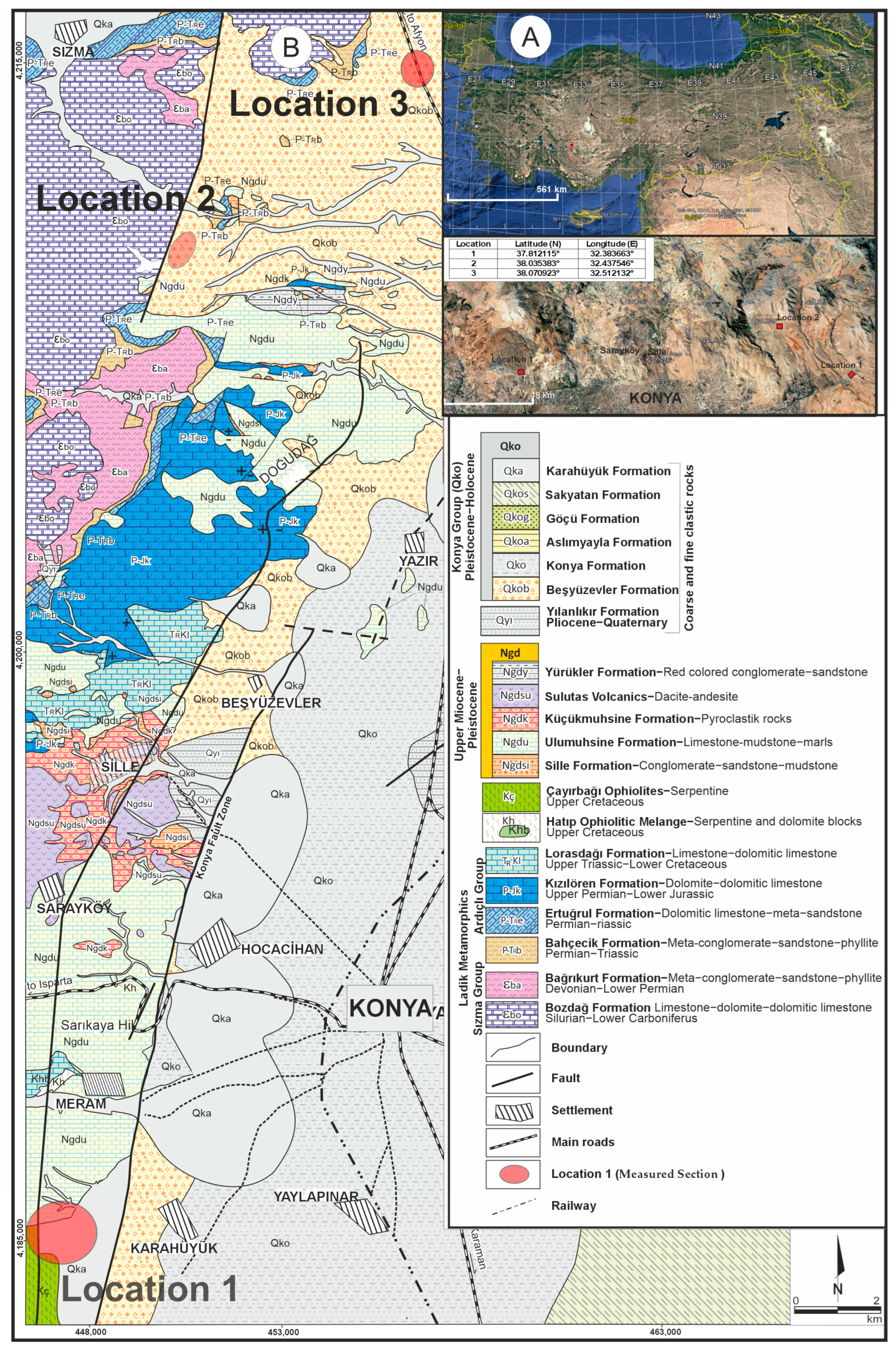
Figure 1). Quaternary sediments (Konya Group) [
34] comprising alluvial fan deposits and young lacustrine sediments cover all older rocks with an angular unconformity. Calcretes and dolocretes generally occur within the red-coloured pebble-, sand-, and mud-dominated terrestrial deposits of the Karahüyük Formation. The Karahüyük Formation is Quaternary in age and constitutes the upper sedimentary unit of the Konya Group. Karahüyük Formation consists of red to burgundy-coloured mud-supported lenticular gravels, pebbly sand, sand and mud, which were deposited in medial-distal fan environments. The thickness of the formation, which is controlled by the active tectonism in the region, varies from 5 to 25 metres [
35]. The alluvial fan deposits are characterized by marked lateral and vertical facies variability over short distances. In many parts of the basin, their development was strongly influenced by syn-sedimentary tectonic activity.
3. Materials and Methods
Dolocretes and calcretes were classified based on their micromorphological and chemical characteristics [
1,
2,
36]. The stratigraphic positions and geological features of the calcretes, which are intensely observed in active fault zones and in their close vicinity, were determined during the field studies. In order to elucidate the ages, geochemical properties, and evolution of the calcretes and dolocretes, four stratigraphic sections from different localities were initially measured, and a total of 40 samples were collected. However, one section was excluded from further analyses because the calcretes contained abundant iron-rich phases and a high proportion of fine-grained detrital material, which obscured the pedogenic carbonate characteristics and could have biased the petrographic, geochemical, and isotopic interpretations. Consequently, the results presented in this study are based on three representative sections (Measured Sections). Samples were subsequently subjected to δ
13C and δ
18O stable isotope analysis, geochemical analysis, thin-section petrography, and ESR (electron spin resonance) dating.
Since the collected samples were loosely packed, 30 samples (Measured Section 1:16, Measured Section 2:8 and Measured Section 3:6) were impregnated with polyester resin prior to thin-section preparation, then thin sections were prepared from these materials.
Major oxide, trace element, and rare earth element (REE) contents of 20 selected representative samples (Measured Section 1:12, Measured Section 2:6 and Measured Section 3:2 samples) were determined by Inductively Coupled Plasma Emission Spectrometry (ICP-ES; major elements) and Inductively Coupled Plasma Mass Spectrometry (ICP-MS; trace elements and REEs) using approximately 0.2 g of powdered material at Bureau Veritas (Vancouver, BC, Canada). The selected samples represent the three investigated stratigraphic sections and the different calcrete and dolocrete types identified in the study area. Samples were first subjected to lithium borate fusion, and the precision and accuracy of the analyses were verified through parallel analyses of international reference standards. The minimum detection limit was 0.01 wt.% for major elements and 0.01–1 ppm for trace elements.
SEM and EDS analyses were carried out at the ILTEK Laboratory of Selçuk University (Türkiye) using a ZEISS EVO LS10 instrument (ZEISS, Oberkochen, Germany). Before analysis, the samples were placed on sample (Measured Section 1:7, Measured Section 2:3 and Measured Section 3:1) holders and dried in an oven at 50 °C for 1 h to remove moisture. The dried samples were then coated with a thin layer of gold in order to increase conductivity and obtain clearer SEM–EDS images and chemical data.
The XRD analyses were conducted at the ILTEK Laboratory of Selçuk University (Konya, Türkiye) using carefully selected well-preserved and uncontaminated samples (Measured Section 1:6, Measured Section 2:3 and Measured Section 3:1).
Carbonate-rich samples were dated using the Electron Spin Resonance (ESR) method, which is based on measuring the number of paramagnetic centres produced by natural radiation within a material [
37,
38,
39,
40]. Equivalent doses (DEs), representing the accumulated natural radiation doses, were determined using the additive dose method. Annual dose rates (D) were calculated from the concentrations of the natural radionuclides (238U, 232Th, 40K), together with the contributions of cosmic radiation, grain-size effects, and moisture content. ESR ages were calculated using the ROSY program (version 2.0) [
40] under the assumption of secular equilibrium (U-equilibrium) in the uranium decay series. Although pedogenic carbonates may locally behave as open systems with respect to uranium, previous studies have demonstrated that the U-equilibrium model can be reliably applied to secondary carbonate deposits when supported by independent geological and stratigraphic evidence [
25,
38,
41,
42,
43,
44]. In the present study, the high CaCO
3 contents of the investigated samples, their well-constrained stratigraphic positions, and the agreement between the obtained ESR ages and the regional geological framework support the application of the U-equilibrium model. Therefore, the reported ESR ages should be regarded as model-dependent estimates within the framework of the adopted assumptions. ESR spectra were recorded at room temperature using a JEOL JES-FA300 X-band ESR spectrometer (JEOL, Tokyo, Japan) at the Selçuk University Advanced Technology Research and Application Center, Türkiye. The stable isotope (δ
18O and δ
13C) analyses of 24 samples (Measured Section 1:14; Measured Section 2:8; Measured Section 3:2) were carried out at the UC Davis Stable Isotope Facility, University of California, Davis, CA, USA, using a MAT 251 Isotope Ratio Mass Spectrometer (Thermo Fisher Scientific, Waltham, MA, USA).
4. Results
4.1. Lithofacies Characteristics of the Karahüyük Formation
The Karahüyük Formation is widely distributed throughout the Konya region (
Figure 1). The alluvial fan deposits within the formation extend basinward along the Konya Fault Zone in the western part of the basin. As the Konya Closed Basin is a graben, the development of the alluvial fan deposits was largely controlled by fault activity. Facies repetition is particularly common near the fault zones, resulting in the vertical stacking of thick sedimentary successions.
The alluvial fan deposits exhibit considerable lateral and vertical facies variations. Although lateral and vertical facies variations are widespread over large areas, the terrestrial carbonates investigated in this study are restricted to very limited outcrops. Therefore, lateral facies variations cannot be observed in the field photographs. Nevertheless, vertical facies changes observed within these small outcrops indicate rapid changes in depositional conditions. The identification of more than 1000 m of subsidence in the Konya Closed Basin since the Middle Pleistocene demonstrates the significance of syn-sedimentary tectonism in the region [
30].
Four different lithofacies have been identified in the Karahüyük Formation at the study area. These are as follows:
Clast-supported, ungraded gravel facies (Lithofacies 1): This facies consists of poorly sorted, clast-supported, granule- to boulder-sized gravel. The framework is supported by grain-to-grain contacts, with muddy sand filling the interstitial spaces between the clasts. The gravel was mainly derived from ophiolitic rocks, limestone, and dolomitic limestone. The deposits are massive and lack clast imbrication. This facies grades vertically and laterally into the pebbly-sandy mud facies. Gravel-coating dolocretes occur within this facies in Measured Section 1.
Pebbly-sandy mud facies (Lithofacies 2): This facies consists of unbedded red mud containing scattered, well-rounded ophiolitic pebbles and sand grains. It grades conformably from the underlying gravel facies into the overlying red mud facies. Nodular calcretes occur in Measured Section 3, whereas nodular and gravel-coating dolocretes occur in Measured Section 1.
Red mud facies (Lithofacies 3): This facies consists predominantly of red mud containing minor amounts of gravel and sand. It has a conformable lower boundary with the underlying pebbly-sandy mud facies and an erosional upper boundary with the overlying mud-supported boulder gravel facies. Both nodular and powdery calcretes occur within this facies.
Angular pebbly-sandy mud facies (Lithofacies 4): This facies consists of muddy deposits containing angular ophiolitic and limestone blocks together with pebbles and sand. The deposits are poorly stratified and poorly sorted. The angular nature of the clasts indicates a nearby sediment source. Layered calcretes occur within this facies in Measured Sections 1 and 2.
The deposition of these thick alluvial fan sediments was controlled by tectonic activity in the study area. Alluvial fan deposits exhibit both lateral and vertical variations [
36]. Having erosional basal boundaries indicate dense erosion and transportation. Lithofacies 1 and 4 is interpreted as deposit of middle fan, Lithofacies 2 and 3 as deposits of distal fan.
4.2. Konya Calcretes and Dolocretes (217.47–389.85 ka)
4.2.1. Description
Terrestrial carbonate occurrences developed within and on the Quaternary sediments of the Karahüyük Formation in the Konya region are described in detail for the first time in this study (
Figure 1). In the study area, terrestrial carbonate deposits developed within Neogene and Quaternary successions are closely associated with fault zones and are concentrated along fault-controlled areas. Samples were collected from three locations along the Konya Fault Zone (
Figure 1).
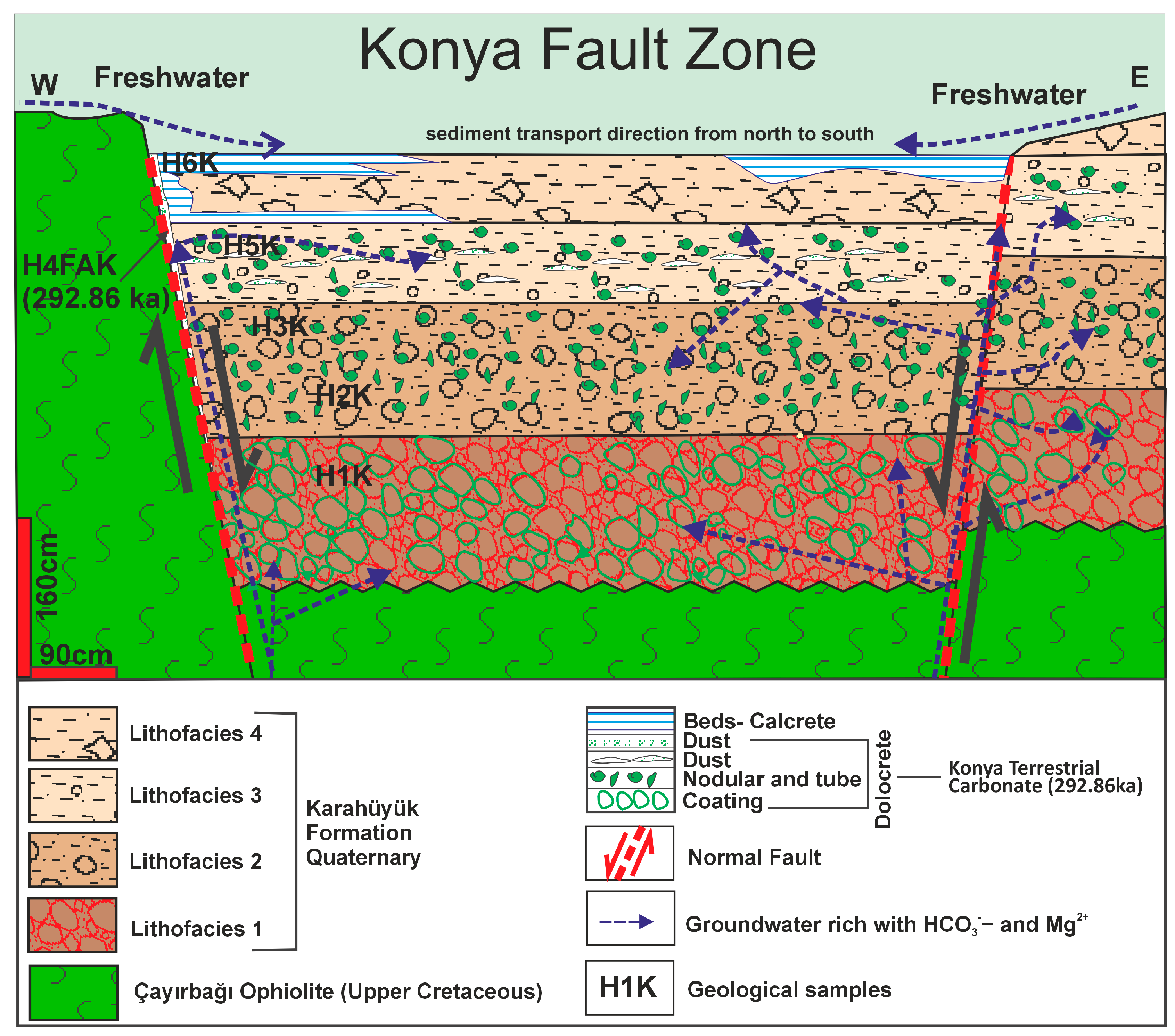
Measured Section (Location) 1: Quaternary red alluvial fan deposits unconformably overlying ophiolitic rocks crop out along a road cut on the Konya-Seydişehir highway. This location corresponds to the first step of the dip-slip normal fault bounding the Konya Graben. The dip-slip fault juxtaposes the Late Cretaceous Çayırbağı Ophiolite and the Quaternary alluvial fan deposits (
Figure 2).
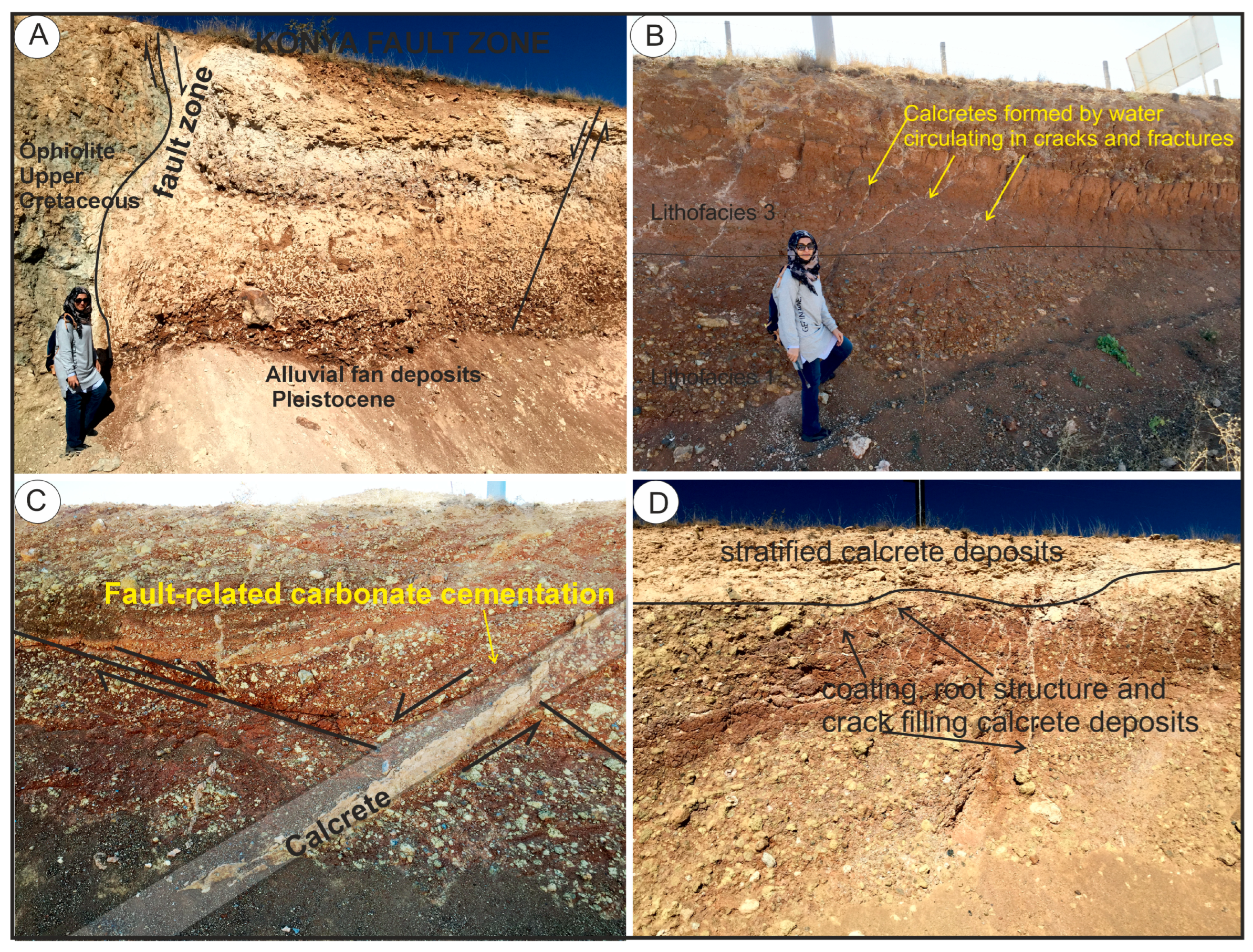
Calcrete and dolocrete occurrences were observed both adjacent to the fault plane and within the mud-supported alluvial fan deposits of the hanging wall block (
Figure 2). Five different calcrete and dolocrete levels were identified within the approximately 6 m-thick exposure (
Figure 2 and
Figure 3A). From bottom to top, these are:
Inclined tube-shaped nodular dolocretes developed obliquely to the surface in gravelly-sandy mud (
Figure 2 and
Figure 3B).
Nodular and powdery calcretes and dolocretes within mud (
Figure 2 and
Figure 3D).
Thick bedded calcretes in muddy level near the surface (
Figure 3 and
Figure 4C).
Figure 3.
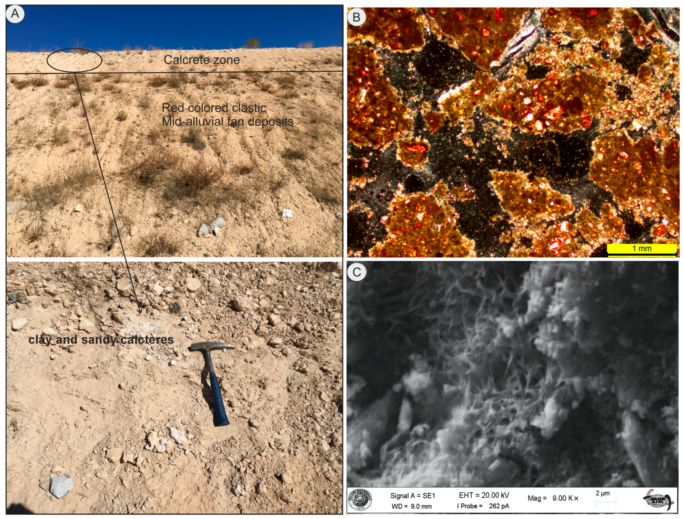
Field photos from Measured Section 1. (A) Calcrete and dolocrete deposits at different levels on the oldest fault plane in the Konya fault zone and alluvial fan deposits; (B–D) dolocretes precipitated into cracks and fractures, coating and root structure; stratified calcrete deposits.
Figure 3.
Field photos from Measured Section 1. (A) Calcrete and dolocrete deposits at different levels on the oldest fault plane in the Konya fault zone and alluvial fan deposits; (B–D) dolocretes precipitated into cracks and fractures, coating and root structure; stratified calcrete deposits.
Figure 4.
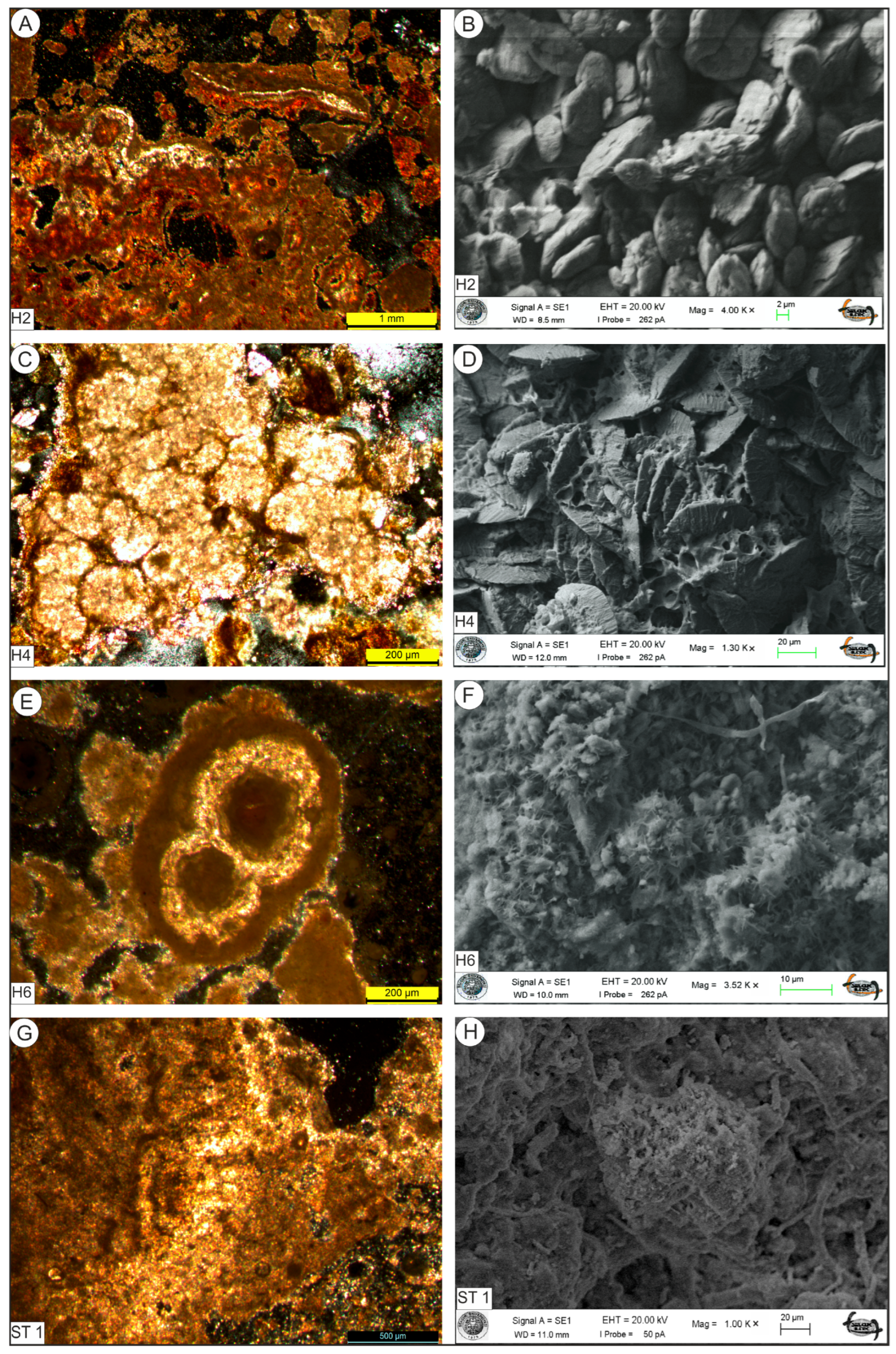
(A–F) Thin section and Scanning Electron Microscope (SEM) photographs of calcrete samples from H2, H4, H6 at Measured Section 1) and (A–D); dolomite minerals observed in H2 and H4 pisolitic calcrete (thin-section and SEM images). (E,F); H6 pisolitic calcrete, (G,H); SEM image of clay minerals (palygorskite), ST1 (Measured Section 2) clay minerals (palygorskite), algae filaments and calcite minerals (H2…H6 and ST 1 geological sample codes).
Figure 4.
(A–F) Thin section and Scanning Electron Microscope (SEM) photographs of calcrete samples from H2, H4, H6 at Measured Section 1) and (A–D); dolomite minerals observed in H2 and H4 pisolitic calcrete (thin-section and SEM images). (E,F); H6 pisolitic calcrete, (G,H); SEM image of clay minerals (palygorskite), ST1 (Measured Section 2) clay minerals (palygorskite), algae filaments and calcite minerals (H2…H6 and ST 1 geological sample codes).
Pebble-coating dolocretes are most common in Lithofacies 1. Nodular dolocretes occur mainly in Lithofacies 2 and 3. Powdery calcretes are common in Lithofacies 3. Almost all nodular (including tube-shaped) and powdery dolocretes occur within fine-grained clastic sediments. Layered calcretes occur at two different levels within Lithofacies 4 (
Figure 2). A powdery calcrete horizon also occurs between these layered calcretes (
Table 1).
The thicknesses of the four calcrete and dolocrete horizons decrease with increasing distance from the fault. Vein-like dolocretes occur along fractures, whereas layered calcretes occur near the surface (
Figure 3B–D). Dolocretes developed along the fault zone, within fractures, and as intergranular cement exhibit lithological, mineralogical, and geochemical characteristics similar to those of the other dolocrete horizons. This indicates that all dolocretes formed through the same pedogenic-meteoric processes and do not represent a separate phase of fault-related carbonate cementation. Pisolitic structures were commonly observed in polyester-impregnated thin sections and SEM images (
Figure 4). At this Measured Section, dolocretes occur throughout the lower 4–5 m of the section (
Figure 4A–F), whereas calcretes are restricted to the uppermost layered horizon. Dolocretes are characterized by disc-shaped dolomite crystals arranged in stacked aggregates (
Figure 4A–D).
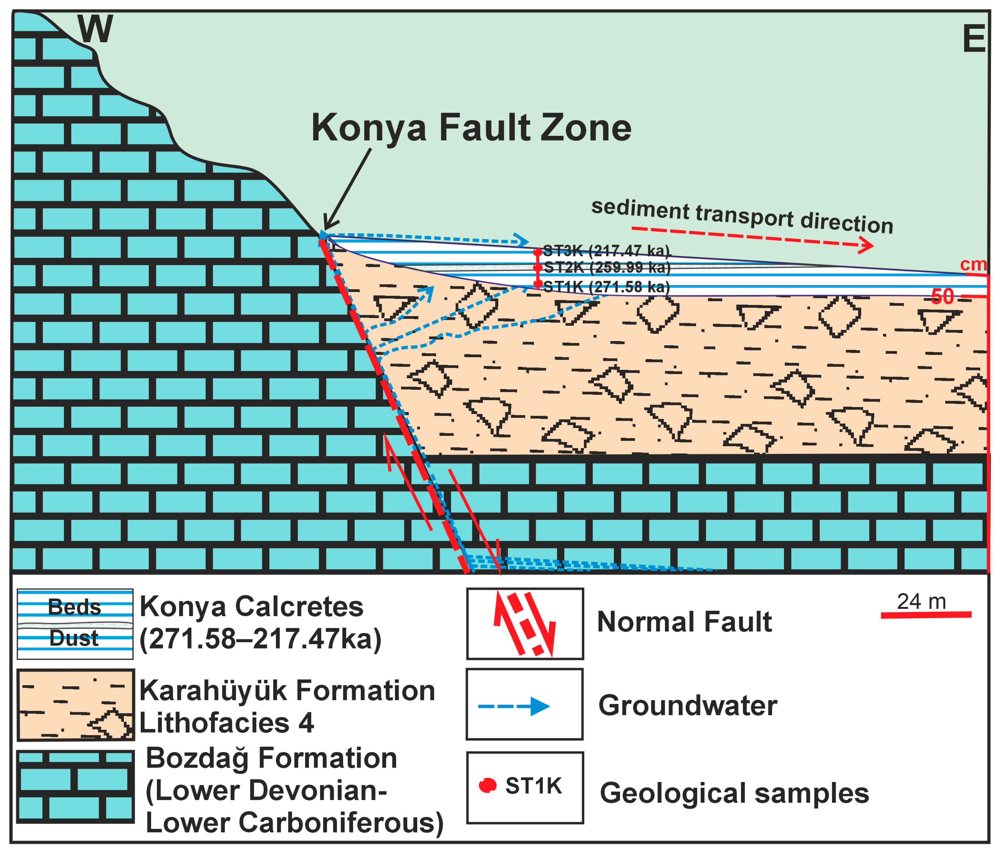
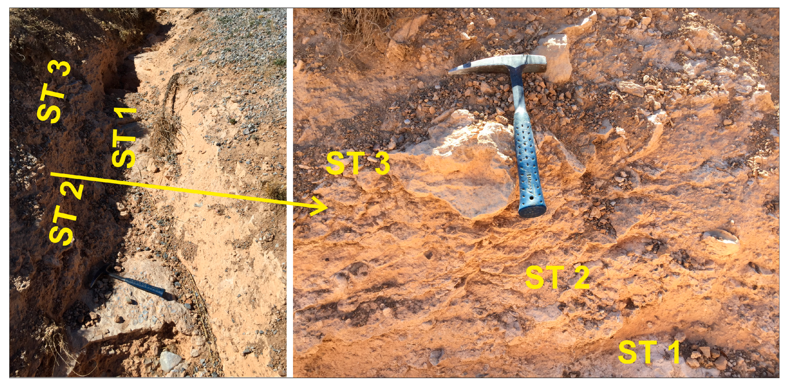
Measured Section (location) 2: This locality is situated immediately north of the Selçuk University campus. As in Measured Section 1, calcretes occur adjacent to the major boundary faults of the Konya Closed Basin (KCB). The alluvial fan deposits of the Karahüyük Formation unconformably overlie Neogene lacustrine carbonate rocks, which in turn rest on Paleozoic marbles. The northern dip-slip fault juxtaposes the young alluvial fan deposits against the Paleozoic marbles. At this site, the Karahüyük Formation crops out adjacent to the fault and is represented by Lithofacies 4 (angular pebbly-sandy mud facies). Layered and powdery calcretes occur within a 1 m thick zone dipping toward the basin adjacent to the fault. The calcretes are well lithified and occur together with clastic sediments (
Figure 5 and
Figure 6). They contain abundant silt- and sand-sized detrital grains. Thin-section observations revealed ooids, pisoids, and pellets (
Figure 4G,H). Calcretes generally occur as layered horizons close to the fault, whereas iron-coated nodules become more common farther from the fault within the soil profile. SEM investigations identified well-crystallized calcite, quartz, and palygorskite, together with silt- and sand-sized detrital particles and evidence of biogenic activity.
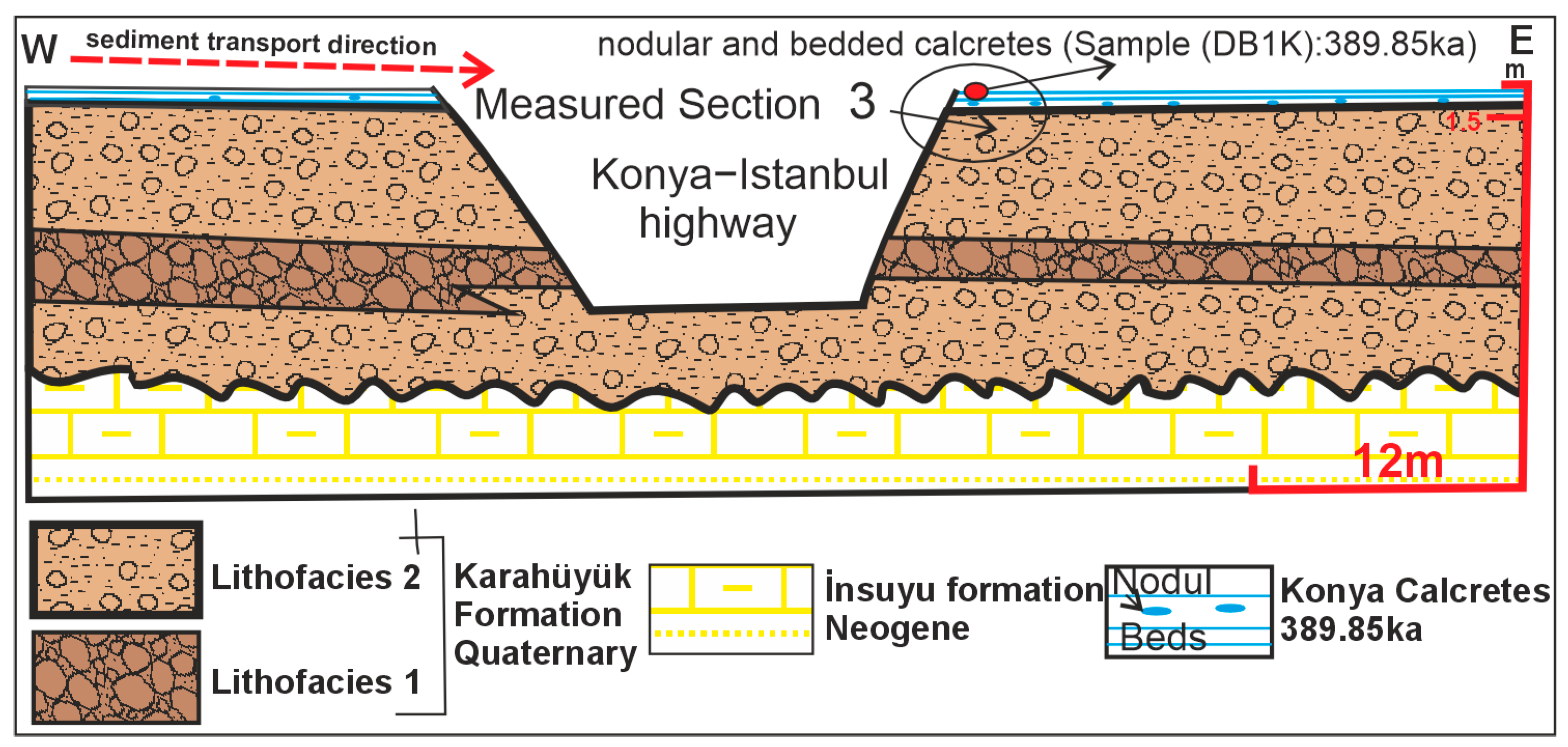
Measured Section (location) 3: This locality is exposed along a road cut on the Konya–Istanbul highway. It is situated on the uplifted footwall block of a dip-slip normal fault. Calcretes occur as nodules and layered horizons within the intermediate alluvial fan deposits of the Karahüyük Formation, which unconformably overlies the İnsuyu Formation (
Figure 7). At this Measured Section, the Karahüyük Formation is represented mainly by Lithofacies 1 and 2. Calcretes are restricted to the uppermost 96 cm of the 15 m thick road-cut exposure (
Figure 8A). The layered calcretes contain abundant silt-, sand-, and fine gravel-sized detrital grains (
Figure 8A,B).
4.2.2. Sedimentary Structure of Calcretes and Dolocretes
Calcretes and dolocretes occur within the alluvial fan and paleosol deposits of the Karahüyük Formation as powdery accumulations, nodules, rhizoliths, tubular structures, layered horizons, and fracture and crack-fillings. Calcretes commonly exhibit pisolitic and tubular morphologies, whereas both layered and pisolitic forms were identified only at Measured Section 2. Dolocretes locally form Fe-rich coatings around pebbles (
Figure 2 and
Figure 3B;
Table 1).
4.2.3. Mineralogy and Petrography
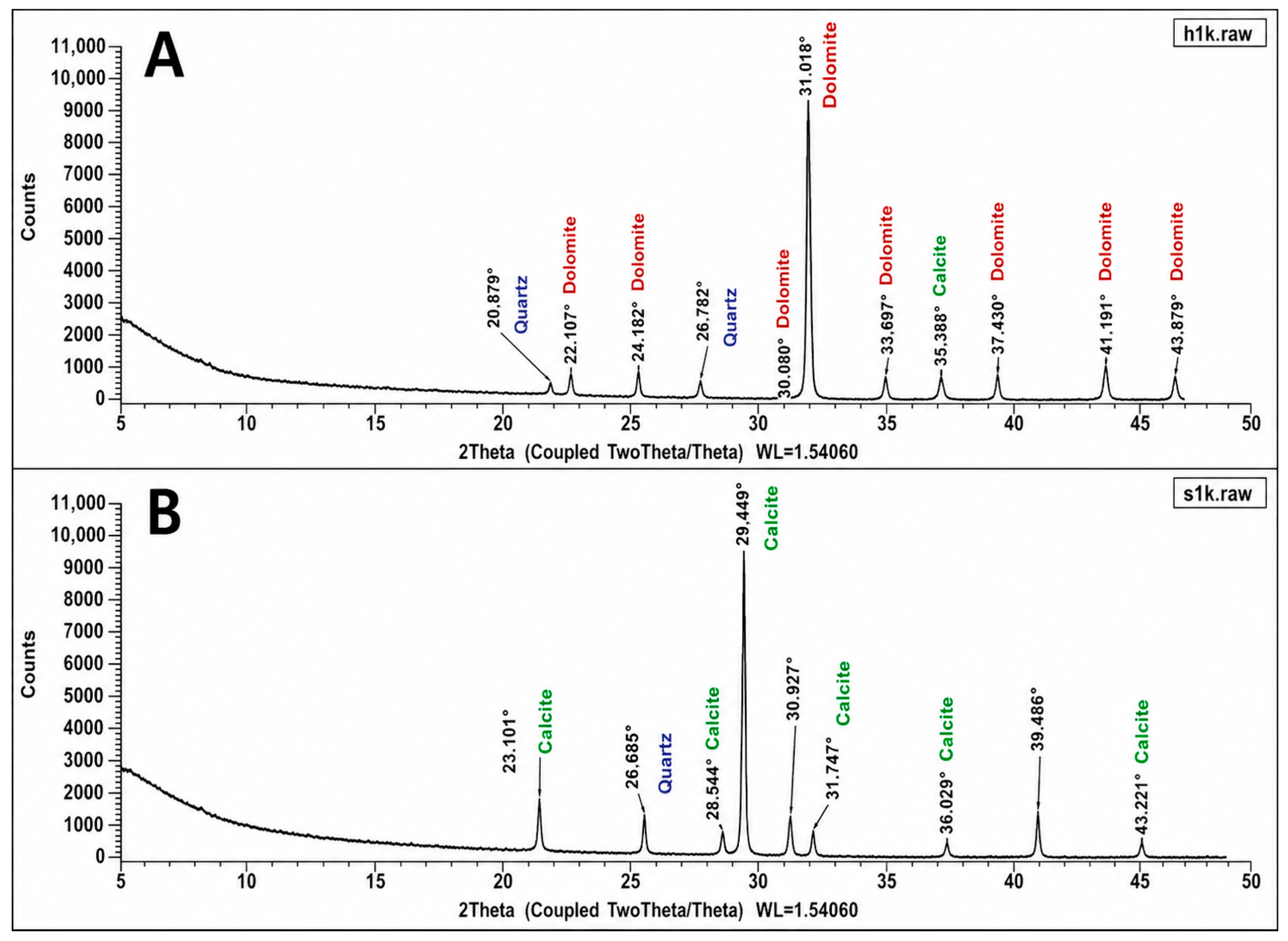
XRD, SEM–EDS, and petrographic analyses were carried out to determine the mineralogical characteristics of the calcretes and dolocretes. Dolomite was identified only in calcretes developed within Quaternary alluvial fan deposits derived from ultramafic–ophiolitic rocks (Measured Section 1), whereas it was not detected in calcretes developed on limestone and dolomitic limestone parent rocks (Measured Sections 2 and 3). Calcite, dolomite, quartz, smectite, and palygorskite were identified in the investigated samples. Carbonate-rich horizons locally alternate with quartz- and clay-rich levels within the same outcrop. Layered calcretes are particularly common in near-surface levels adjacent to the fault. Although the calcretes generally exhibit layered and massive fabrics, ooidal and pisoidal textures were also locally observed during petrographic examination. Calcite and dolomite were confirmed by both XRD and SEM–EDS analyses (
Figure 3,
Figure 4,
Figure 8 and
Figure 9). In addition, filamentous microbial structures closely associated with carbonate crystals were observed in several samples (
Figure 4F and
Figure 8C).
XRD analyses identified calcite as the dominant carbonate mineral in the calcrete samples. Characteristic calcite reflections were detected in all calcrete samples. Petrographic investigations revealed micritic and microsparitic carbonate textures. Laminated carbonate horizons and fracture-filling carbonate precipitates were also observed in some samples.
In addition to calcite, significant amounts of dolomite were identified in the dolocrete samples. The presence of dolomite was confirmed by XRD analyses, whereas SEM observations revealed stacked discoidal dolomite crystal aggregates within the carbonate matrix.
Quartz represents the most abundant non-carbonate mineral phase. Quartz grains are dispersed throughout the carbonate matrix and exhibit detrital textures with variable grain sizes. Trace amounts of feldspar were also identified in some samples.
The clay mineral assemblage is dominated by palygorskite and smectitic minerals. SEM images reveal fibrous, rod-like, and network-shaped morphologies of palygorskite. Smectitic minerals occur as flocculated and irregular aggregates within the carbonate matrix. Clay minerals commonly occur together with carbonate minerals and, in some samples, form thin coatings and layers surrounding quartz grains.
SEM observations also revealed filamentous microbial structures, tubular voids, coated grains, nodular carbonate accumulations, and laminated carbonate horizons. Carbonate infillings were observed within pores and locally along fractures.
4.2.4. Geochemistry
The results of the chemical analyses of the terrestrial carbonate samples are presented in
Table 2,
Table 3 and
Table 4. At Measured Section 1, the MgCO
3 content ranges from 16.67 to 43.94 wt.%, whereas CaO contents vary between 8.44 and 37.13 wt.%. The EDS analyses are consistent with the bulk geochemical data. Six carbonate horizons were identified at this Measured Section. Of these, only Horizon H6 is calcitic in composition, whereas the remaining horizons are dominantly dolomitic. The calcrete from Horizon H3 is distinguished by a relatively higher SiO
2 content than the other horizons.
At Measured Section 2, MgCO3 contents range from 0.98 to 2.07 wt.%, CaO contents from 45.05 to 51.26 wt.%, and SiO2 contents from 3.22 to 8.24 wt.%. Compared with Measured Section 2, the terrestrial carbonates at Measured Section 1 exhibit markedly higher MgCO3 contents and lower CaO contents, reflecting their predominantly dolomitic composition.
At Measured Section 3, MgCO3 contents range from 8.07 to 9.06 wt.%, CaO contents from 34.94 to 40.16 wt.%, and SiO2 contents from 14.38 to 20.59 wt.%. Compared with Measured Section 2, the terrestrial carbonates at Measured Section 3 contain higher MgCO3 and SiO2 contents and lower CaO contents.
The mineralogical and geochemical data are in good agreement. High CaO contents (34.94–51.26 wt.%) correspond to calcite-rich samples, whereas elevated MgO (11.65–21.01 wt.%) and MgCO3 contents characterize the dolocrete samples. Higher SiO2, Al2O3, TiO2, and K2O contents occur in samples containing abundant quartz and clay minerals.
Trace-element analyses indicate elevated Ni (14.4–1239.1 ppm), Co (4.3–94.6 ppm), Cr, and V concentrations, particularly in the dolocrete samples. In contrast, Sr concentrations in the calcrete samples reach up to 855.4 ppm. The concentrations of Rb, Nb, Th, Zr, and Y show variable distributions among the investigated samples (
Table 3).
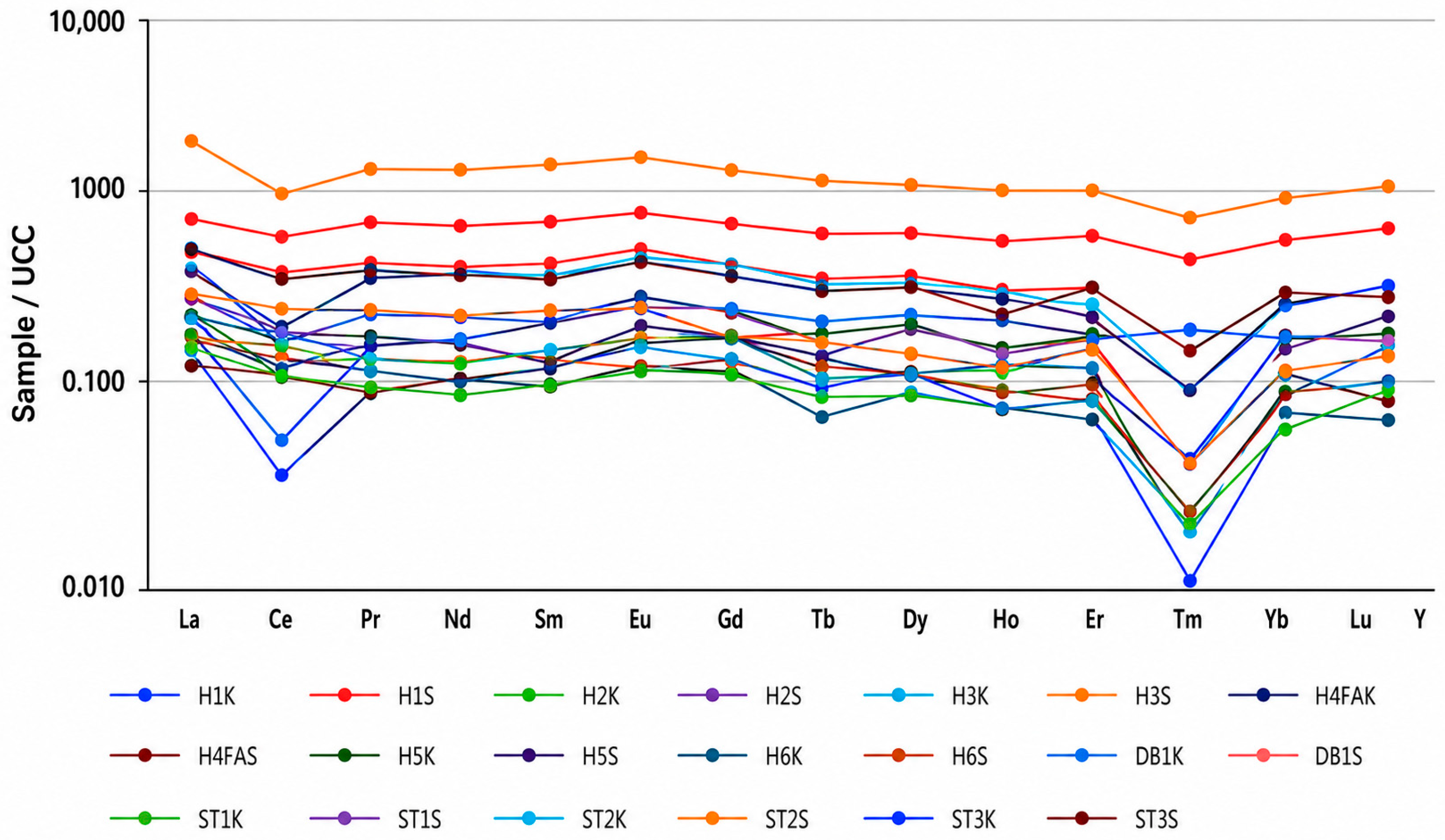
Rare earth element (REE) analyses show that light rare earth elements (LREEs) are enriched relative to heavy rare earth elements (HREEs) in all samples. The highest REE concentrations were recorded in samples H3S and DB1S. La, Ce, Nd, and Sm are the dominant REE components, whereas Eu and Lu occur at comparatively lower concentrations. REE concentrations were normalized to the Upper Continental Crust (UCC) values of Taylor and McLennan [
45]. Ce and Eu anomalies were calculated using the following equations:
where the subscript N denotes UCC-normalized REE concentrations, and Ce and Eu represent the expected Ce and Eu values interpolated from the adjacent normalized REE concentrations. The calculated UCC-normalized
Ce/
Ce* values range from 0.264 to 1.096, whereas
Eu/
Eu* values range from 0.935 to 1.372 (
Table 4).
4.2.5. Stable Isotope Geochemistry
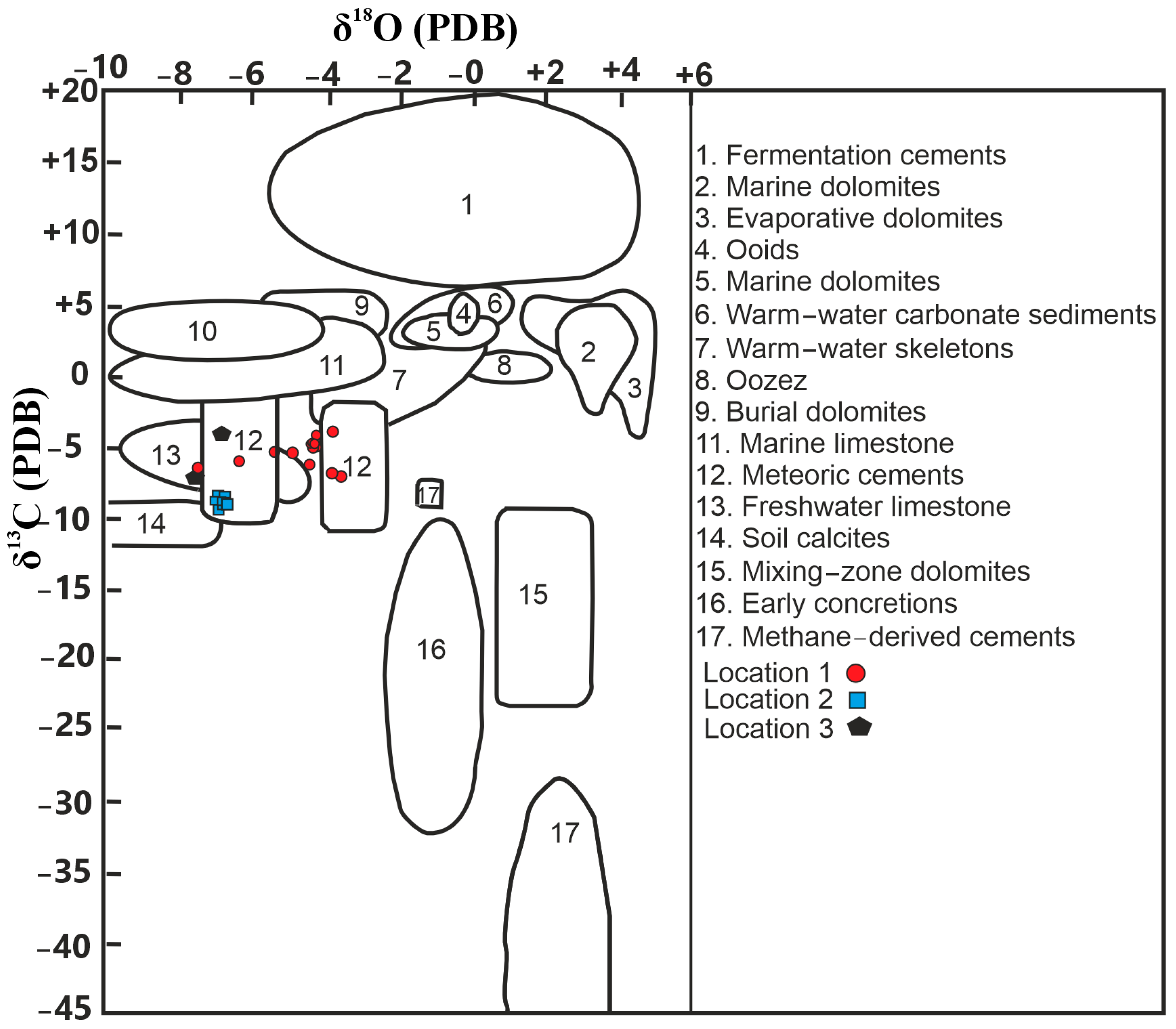
The stable carbon isotope (δ
13C) values of the dolocretes vary between −7.45‰ and −4.02‰ VPDB, while the stable oxygen isotope (δ
18O) values range from −4.78‰ to −3.74‰ VPDB. In comparison, the calcretes display δ
13C values ranging from −7.41‰ to −3.62‰ VPDB and δ
18O values ranging from −9.69‰ to −7.12‰ VPDB (
Table 5).
4.2.6. Geostatistical Analyses
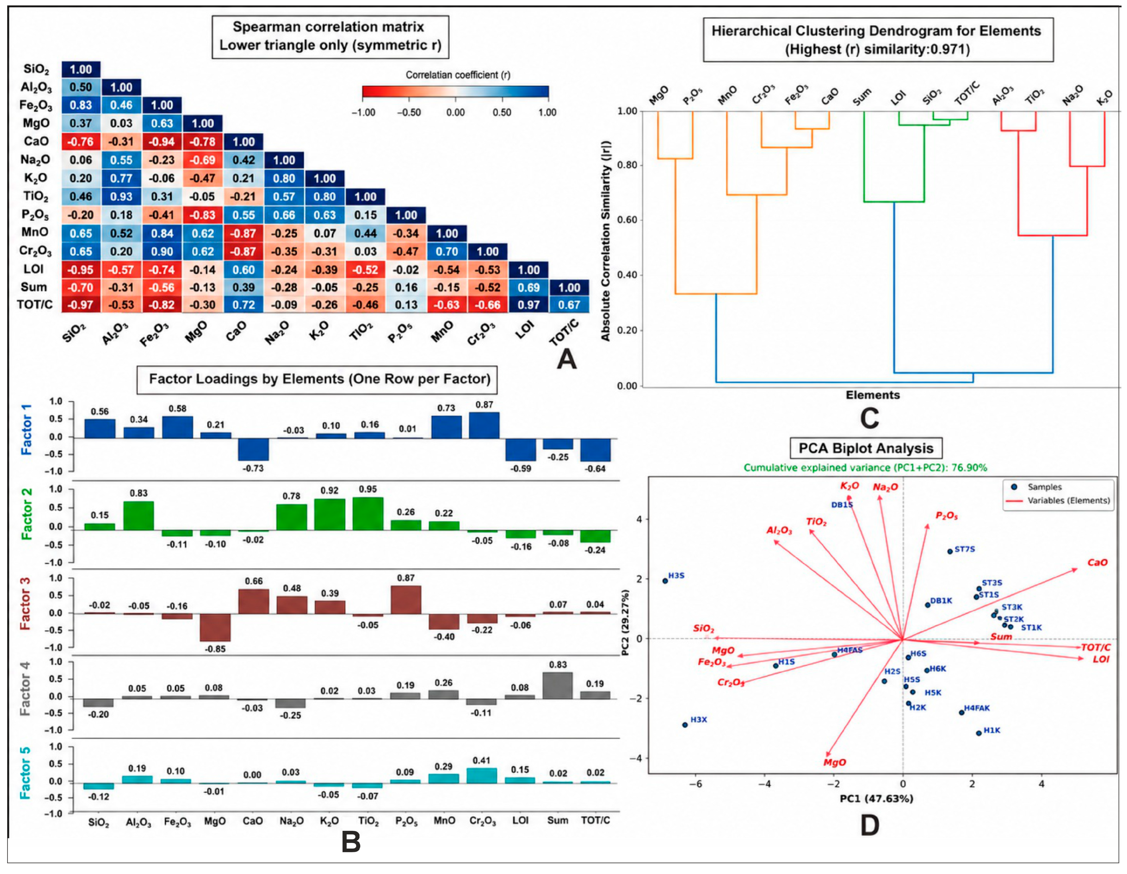
Spearman correlation analysis reveals strong positive correlations among CaO, LOI, and TOT/C, whereas SiO
2, Fe
2O
3, Cr
2O
3, and MnO exhibit negative correlations with these variables (
Figure 10A). MgO shows negative correlations with CaO, LOI, and TOT/C. Positive correlations are also observed between Al
2O
3 and TiO
2, and between K
2O and Na
2O.
Factor analysis extracted five principal factors describing the geochemical variability of the investigated samples (
Figure 10B). Factor 1 is characterized by positive loadings of LOI, TOT/C, and CaO and negative loadings of SiO
2, Fe
2O
3, and Cr
2O
3. Factor 2 is dominated by Al
2O
3, TiO
2, K
2O, and Na
2O, whereas Factor 3 is mainly characterized by MgO together with MnO and P
2O
5. Factors 4 and 5 account for the remaining geochemical variability.
Hierarchical cluster analysis groups LOI, TOT/C, and CaO within the same cluster, whereas SiO
2, Fe
2O
3, and Cr
2O
3 form a separate cluster. Al
2O
3, TiO
2, K
2O, and Na
2O constitute another distinct cluster (
Figure 10C). The sample dendrogram separates carbonate-rich samples from Mg-rich and siliciclastic-rich samples.
Principal component analysis (PCA) shows that the first two principal components explain 76.90% of the total variance (
Figure 10D). PC1 is characterized by positive loadings of CaO, LOI, and TOT/C and negative loadings of SiO
2, Fe
2O
3, and Cr
2O
3, whereas PC2 is mainly associated with Na
2O, K
2O, Al
2O
3, TiO
2, and MgO. The PCA biplot separates the investigated samples into three major geochemical clusters.
4.2.7. Age of Calcretes and Dolocrete by ESR Method
In this study, samples were dated by means of ESR method. The ESR ages were calculated using the equations of [
37] assuming secular equilibrium in the uranium decay series. Equivalent dose (DE), annual dose (D) and ESR age (TESR) values of calcrete samples are listed in
Table 6 and
Table 7. Among these samples, H4FAK was collected from the fault surface. Among these samples, H4FAK was collected from the fault surface.
5. Discussion
5.1. Pedogenic–Meteoric Origin of the Konya Terrestrial Carbonates
Field observations, petrographic analyses, mineralogical data, and isotopic evidence collectively indicate that the terrestrial carbonates of the Konya Basin developed within a common pedogenic–meteoric system despite their morphological variability. Nodular, tubular, powdery, layered, and coating-type carbonate accumulations, together with micritic textures, root-related voids, and microbial structures, indicate carbonate precipitation under near-surface conditions. These features are consistent with the classical criteria of pedogenic carbonates described by [
1,
8,
9]. Similar morphologies have also been reported from Quaternary pedogenic carbonates formed in semi-arid environments [
3,
46,
47].
The rhizoliths, tubular carbonate structures, root-related voids, and microbial filaments identified in the Konya terrestrial carbonates provide additional evidence for biologically mediated carbonate accumulation. According to [
48], rhizogenic calcretes develop through localized increases in alkalinity and carbonate supersaturation around plant roots. Similarly, microbial activity may enhance carbonate precipitation by modifying pore-water chemistry and creating nucleation sites for calcite growth. The abundance of root-related and microbial structures observed in the investigated samples therefore suggests that vegetation and soil biological processes played a significant role during carbonate formation [
49].
The pedogenic origin of the Konya terrestrial carbonates is supported not only by their morphology but also by petrographic and mineralogical evidence. Micritic carbonate fabrics, biogenic features, and locally developed tubular carbonate structures observed in thin sections indicate carbonate precipitation within the soil profile under low-temperature conditions. Comparable petrographic characteristics were reported from Quaternary calcretes in southern Türkiye by [
26,
49], who related these features to pedogenic processes. However, the occurrence of both calcretes and dolocretes within the same basin indicates a more complex pedogenic–hydrogeochemical evolution than that reported in previous studies.
The coexistence of nodular, tubular, coated, powdery, and laminated carbonate fabrics indicates progressive pedogenic evolution and prolonged soil development. Similar evolutionary patterns have been documented in Quaternary calcretes from Central Anatolia [
50,
51], Sudan [
47], and Iran [
52]. Consequently, the Konya terrestrial carbonates are interpreted as mature pedogenic systems recording long-term landscape stability and repeated wetting–drying cycles.
Therefore, the terrestrial carbonates of the Konya Basin are interpreted as products of an integrated pedogenic–meteoric system controlled by meteoric groundwater circulation, pedogenesis, biological activity, and semi-arid climatic conditions. Together, these processes governed carbonate precipitation within the vadose zone and produced the diverse calcrete and dolocrete morphologies observed throughout the study area.
5.2. Role of the Konya Fault Zone in Carbonate Formation
Although the terrestrial carbonates are preferentially distributed along the Konya Fault Zone, they do not represent fault-related carbonate cementation. Instead, field observations, sedimentological characteristics, petrographic evidence, mineralogical assemblages, stable isotope compositions, ESR chronology, and geostatistical analyses consistently indicate that both calcretes and dolocretes developed within pedogenic soil horizons under meteoric conditions [
1,
3,
9,
53,
54]. Accordingly, the fault zone provided the hydrogeological framework for carbonate formation rather than acting as the direct mechanism of carbonate precipitation or as a source of tectonic or hydrothermal carbonate cementation.
The principal role of the Konya Fault Zone was to control the local hydrogeological regime. Fault-related fracturing increased secondary permeability and created preferential pathways for meteoric groundwater circulation within the Quaternary alluvial fan deposits [
55,
56]. Repeated groundwater circulation through these permeable zones promoted carbonate supersaturation during successive wetting–drying cycles, thereby favouring pedogenic carbonate accumulation within the soil profile [
1,
3]. Consequently, although the spatial distribution of the terrestrial carbonates is structurally controlled by the fault system, their fabrics, mineralogical characteristics, and internal microstructures clearly indicate pedogenic development.
The contrasting occurrence of dolocretes at Measured Section 1 and calcic calcretes at Measured Sections 2 and 3 further demonstrates the importance of parent-rock composition. At Measured Section 1, Quaternary alluvial fan deposits derived from ultramafic–ophiolitic rocks supplied Mg
2+ to circulating meteoric groundwater, favouring local dolomite precipitation. In contrast, the alluvial fan deposits at Measured Sections 2 and 3 were derived predominantly from carbonate bedrock, where groundwater chemistry favoured calcite precipitation and pedogenic calcrete development [
7,
46,
57]. The geostatistical analyses further support this interpretation by distinguishing Mg-rich dolocrete samples from calcite-dominated calcretes, indicating that the two terrestrial carbonate types followed different geochemical evolution pathways primarily controlled by bedrock lithology and groundwater chemistry.
The combined sedimentological, petrographic, mineralogical, geochemical, isotopic, geostatistical, and chronological evidence demonstrates that the Konya Fault Zone functioned primarily as a structural and hydrogeological control on terrestrial carbonate formation. The fault system controlled alluvial fan architecture, groundwater circulation, fracture permeability, and local hydrochemical conditions, whereas pedogenic processes remained the dominant mechanism responsible for carbonate precipitation and the development of calcrete and dolocrete horizons. This genetic model explains both the close spatial association of the terrestrial carbonates with the Konya Fault Zone and the unequivocal pedogenic features preserved within the carbonate horizons.
5.3. Calcrete–Dolocrete Differentiation and Mineralogical Evolution
A notable feature of the Konya terrestrial carbonates is the coexistence of both calcrete and dolocrete systems within the same fault-controlled basin. Although all investigated terrestrial carbonates formed under broadly similar climatic conditions, significant differences in mineralogical composition, major-element geochemistry, and trace-element distributions indicate that their formation was governed by distinct hydrogeochemical processes. Carbonates at Measured Sections 2 and 3 are calcite-dominated and display typical calcrete characteristics, whereas those at Measured Section 1 are characterized by elevated MgO contents, the presence of dolomite, and distinctive trace-element signatures indicative of dolocrete development. These differences demonstrate that parent-rock lithology exerted a primary control on carbonate evolution within the Konya Basin.
The elevated MgO concentrations together with enrichment in Ni, Co, Cr, and V at Measured Section 1 indicate that carbonate-forming solutions became enriched in magnesium through interaction with ultramafic–ophiolitic rocks. Similar geochemical characteristics have been reported from dolocretes in the Çanakkale Basin, Türkiye [
57], the Tuz Gölü Basin, Central Anatolia [
50,
58], and the Eskişehir Basin, Türkiye [
59]. However, the higher trace-element concentrations observed in the Konya dolocretes suggest a stronger ultramafic influence and more prolonged water–rock interaction than in many previously reported examples.
The dolomite–palygorskite–smectite mineral association further supports this interpretation. Previous studies have shown that such mineral assemblages commonly develop during the evolution of Mg-rich alkaline solutions under semi-arid conditions and constitute important indicators of dolocrete formation [
50,
57,
58]. Comparable mineral associations have also been reported from the Madrid Basin, Spain [
60], where palygorskite and sepiolite formed within evaporative carbonate systems. The occurrence of similar mineral assemblages in the Konya deposits suggests that carbonate precipitation and clay-mineral formation evolved within the same hydrogeochemical system.
Despite their occurrence along the same fault-controlled basin margin, the three investigated locations exhibit markedly different mineralogical and geochemical characteristics. These observations indicate that bedrock lithology exerted a stronger influence on carbonate mineralogy than tectonic position alone. The coexistence of calcrete and dolocrete systems within the same basin further demonstrates that regional climatic conditions alone cannot explain the observed mineralogical differences. Instead, local lithology, groundwater chemistry, and weathering intensity exerted first-order controls on carbonate evolution.
Whereas magnesium enrichment is clearly linked to the weathering of ultramafic rocks, carbonate precipitation also required a continuous source of calcium. At Measured Sections 2 and 3, dissolution of limestone and marble units likely represented the principal source of dissolved calcium. In contrast, weathering of silicate and ultramafic rocks may have supplied additional Ca to groundwater systems at Measured Section 1. Similar mechanisms were documented by [
61], who demonstrated that pedogenic carbonates may act as important sinks for calcium released during silicate weathering. Therefore, both carbonate dissolution and silicate weathering contributed to the geochemical evolution of the Konya terrestrial carbonates.
Accordingly, calcretes developed at Measured Sections 2 and 3 are dominated by calcite and display only limited Mg enrichment, indicating precipitation from Ca-rich meteoric waters derived predominantly from the dissolution of carbonate bedrock. In contrast, the dolocretes at Measured Section 1 record the influence of Mg-rich groundwater generated through interaction with ultramafic–ophiolitic rocks. Consequently, calcretes and dolocretes formed under the same regional climatic regime but evolved through distinct hydrogeochemical pathways controlled primarily by bedrock lithology and groundwater chemistry.
5.4. Hydrological Controls and Clay Mineral Formation
The spatial distribution, mineralogical composition, and geochemical characteristics of the Konya terrestrial carbonates indicate that groundwater circulation was one of the principal controls on carbonate formation. The close association between carbonate accumulations and fault-controlled zones suggests that meteoric waters circulated preferentially along structural discontinuities, promoting water–rock interaction and carbonate precipitation. Consequently, hydrological processes played a key role in controlling both carbonate mineralogy and the distribution of associated clay minerals.
Although carbonate accumulations are spatially associated with fault systems, geochemical and isotopic evidence indicates that carbonate precipitation was controlled primarily by near-surface meteoric waters rather than by deep-seated hydrothermal fluids. The available evidence suggests that faults acted mainly as hydrogeological conduits, facilitating groundwater circulation, enhancing water–rock interaction, and promoting carbonate precipitation within the vadose zone. Therefore, tectonic structures controlled the pathways of groundwater flow rather than the geochemical origin of the carbonates themselves.
During relatively humid periods, meteoric waters likely promoted the dissolution of carbonate and ultramafic rocks, resulting in the mobilization of Ca and Mg. During subsequent drier intervals, evapotranspiration, CO
2 degassing, and capillary rise favoured carbonate precipitation within the vadose zone. Similar hydrological models have been proposed for pedogenic carbonate systems by [
3,
28,
60,
61].
The formation of palygorskite appears to be closely related to the hydrogeochemical evolution of the Konya terrestrial carbonates. High-pH conditions, Mg-rich alkaline solutions, and limited leaching provided favourable conditions for palygorskite precipitation under semi-arid climates [
3,
7,
28,
50,
57,
59,
60,
62]. Previous studies have associated palygorskite formation with pedogenic carbonate development and evaporative groundwater systems in the Mio-Pleistocene dolocretes [
63], the Tuz Gölü Basin, Central Anatolia [
50], the Eskişehir Basin, Türkiye [
59], and the Madrid Basin, Spain [
60]. The close association of palygorskite with dolomite and smectitic clay minerals, together with its fibrous morphology observed in SEM images, indicates predominantly authigenic formation within the soil profile rather than simple detrital inheritance. Consequently, the palygorskite-bearing mineral assemblages of the Konya Basin constitute an important mineralogical indicator of meteoric groundwater circulation, alkaline pore-water evolution, prolonged evaporation, and semi-arid pedogenesis.
Accordingly, the clay minerals identified in the study area are not merely mineralogical constituents but also valuable indicators of meteoric groundwater circulation, evaporation, alkaline pore-water evolution, and pedogenic processes.
5.5. Geochemistry, Trace Elements, Rare Earth Elements and Geostatistical Evidence
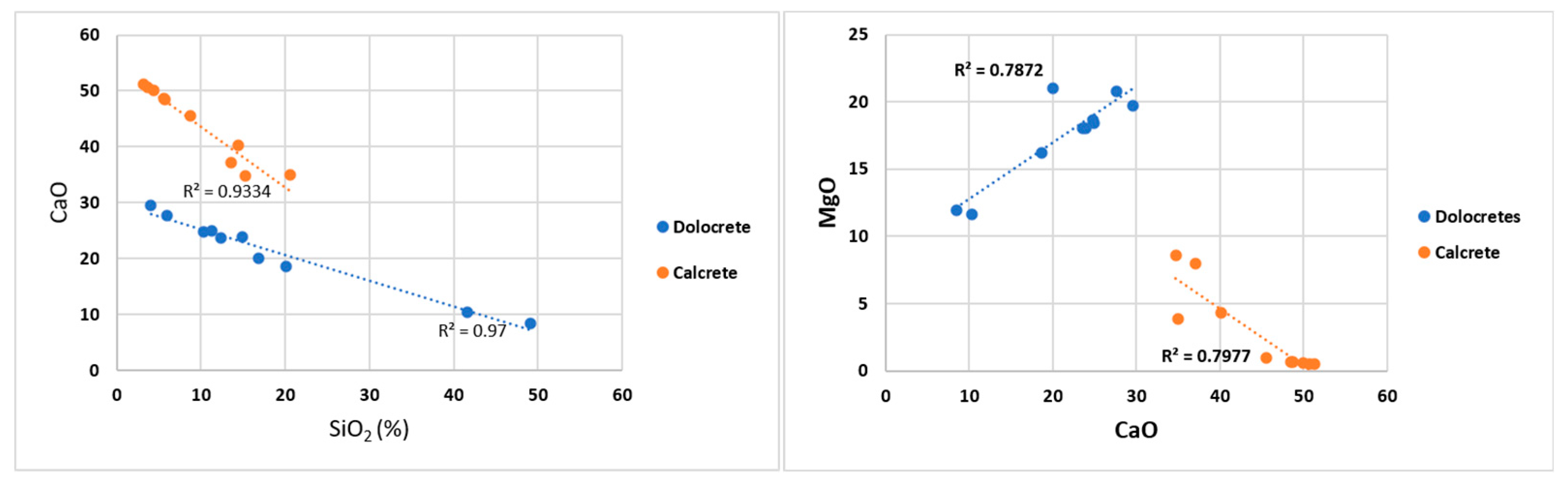
Geochemical data indicate that carbonate accumulation was the principal process controlling the geochemical evolution of the studied terrestrial carbonates. Strong positive correlations among CaO, LOI, and total carbon reflect carbonate precipitation, whereas inverse relationships involving SiO
2, Fe
2O
3, Cr
2O
3, and MnO indicate the differentiation of carbonate-rich horizons from intervals influenced by siliciclastic input (
Figure 11). Similar geochemical relationships have been reported in pedogenic carbonates by [
13,
52,
63,
64].
The elevated MgO, Ni, Co, and Cr contents observed in the dolocretes reflect the influence of ultramafic source rocks. Nevertheless, the distribution of these elements cannot be explained solely by provenance. Ref. [
64] demonstrated that trace-element behaviour in pedogenic carbonates may also be influenced by water–rock interaction and carbonate precipitation processes. The enrichment patterns observed in the Konya dolocretes therefore likely reflect the combined influence of lithological inheritance and subsequent hydrogeochemical evolution.
The geostatistical analyses provide independent support for the proposed genetic model of the Konya terrestrial carbonates. Strong positive correlations among CaO, LOI, and TOT/C indicate that pedogenic carbonate precipitation was the dominant geochemical process during carbonate formation. Conversely, inverse relationships between these parameters and SiO
2, Fe
2O
3, Cr
2O
3, and MnO demonstrate that increasing siliciclastic input diluted the carbonate fraction. Such relationships are characteristic of pedogenic carbonate systems, where variations in carbonate accumulation largely reflect changes in the relative contribution of detrital siliciclastic material [
5,
9].
The association between Fe
2O
3, Cr
2O
3, and MnO further suggests a contribution from mafic source rocks, whereas the strong positive relationships among Al
2O
3, TiO
2, K
2O, and Na
2O indicate a common feldspathic and clay-rich aluminosilicate source. These relationships are consistent with the heterogeneous lithological composition surrounding the Konya Closed Basin and demonstrate that parent-rock lithology exerted an important control on the geochemical characteristics of the terrestrial carbonates [
63,
65,
66,
67].
The inverse relationship between MgO and carbonate-related parameters indicates that Mg-rich carbonate phases developed independently of the dominant calcite precipitation process. This interpretation is fully consistent with the mineralogical observations showing that dolomite occurs exclusively at Measured Section 1, where Quaternary alluvial fan deposits unconformably overlie ultramafic–ophiolitic rocks. Therefore, the elevated Mg contents are interpreted to reflect local lithological control and groundwater–rock interaction rather than regional variations in carbonate precipitation. The increase in the Mg/Ca ratio during dolocrete formation further supports localized dolomitization controlled by Mg supplied from ultramafic parent rocks [
50,
53].
Multivariate statistical analyses further demonstrate that carbonate-rich, siliciclastic-rich, and Mg-rich samples represent distinct geochemical populations. Factor analysis distinguishes the principal geochemical processes controlling carbonate precipitation, detrital sediment input, weathering, and dolomitization, whereas cluster analysis and principal component analysis (PCA) consistently separate calcrete and dolocrete samples into different geochemical groups. These results indicate that the investigated terrestrial carbonates followed distinct geochemical evolution pathways controlled primarily by parent-rock lithology, groundwater chemistry, and pedogenic processes rather than by a single carbonate-forming mechanism. Similar statistical relationships have been documented in pedogenic carbonate systems developed under semi-arid climatic conditions.
Rare earth element (REE) distributions provide important evidence for the interaction among pedogenesis, weathering, and detrital input. Samples H3S and DB1S exhibit the highest REE concentrations and are characterized by elevated SiO
2, Al
2O
3, and TiO
2 contents, indicating that aluminosilicate minerals and clay-rich fractions acted as the principal REE carriers. Similar observations were reported by [
68,
69,
70], who demonstrated that REE enrichment in pedogenic carbonate systems is commonly controlled by clay minerals, Fe oxides, and weathering-derived detrital phases rather than by carbonate minerals alone.
Comparison of UCC-normalized REE patterns [
67] indicates that REE distributions reflect both lithological inheritance and subsequent pedogenic fractionation processes. The calculated Ce/Ce* values range from 0.264 to 1.096, with most samples exhibiting weak to moderate negative Ce anomalies, indicating carbonate precipitation under oxidizing meteoric–vadose conditions, where Ce was preferentially oxidized from Ce
3+ to the less soluble Ce
4+ and subsequently removed from the system [
45]. In contrast, Eu/Eu* values range from 0.935 to 1.372, indicating predominantly weak to moderate positive Eu anomalies that are interpreted to reflect water–rock interaction, source-rock weathering, and geochemical fractionation during carbonate precipitation rather than a distinct redox signal [
67,
71,
72]. The coexistence of predominantly negative Ce and positive Eu anomalies indicates that the terrestrial carbonates formed under oxidizing pedogenic conditions while preserving the geochemical signature of the parent material. These observations indicate that calcrete and dolocrete development in the study area was governed by meteoric groundwater, pedogenic processes, and continued water–rock interaction [
46,
71,
72] (
Figure 12). Overall, the REE distributions support a predominantly pedogenic–meteoric origin and provide no evidence for significant hypogene or hydrothermal contributions.
Therefore, REE distributions not only provide information on source-rock characteristics but also record pedogenic modification, detrital input, and the environmental evolution of the terrestrial carbonate system.
5.6. Stable Isotopes, Vegetation and Paleoclimate
Stable carbon and oxygen isotopes provide important constraints on the environmental conditions under which the Konya terrestrial carbonates formed. The δ
13C and δ
18O values obtained from the investigated samples fall within the range commonly reported for pedogenic carbonates developed under semi-arid climatic conditions. According to [
27,
73,
74], δ
13C values primarily reflect the isotopic composition of soil CO
2 and vegetation cover, whereas δ
18O values are influenced by the isotopic composition of meteoric waters, evaporation intensity, and groundwater dynamics.
The isotopic compositions of the Konya terrestrial carbonates are broadly comparable to those reported from Quaternary calcretes in southern Türkiye by [
26,
47], suggesting precipitation from meteoric waters under vegetation dominated primarily by C3 plants. According to [
26], pedogenic carbonates formed beneath C3-dominated vegetation typically display negative δ
13C values comparable to those observed in the investigated samples. Similar isotopic trends have also been reported from pedogenic carbonates in southern Türkiye [
7], Central Anatolia [
51], and Sudan [
47]. Slight enrichment in δ
13C values observed in several samples may reflect localized increases in evaporation intensity, reduced biological productivity, or variations in soil-respired CO
2.
However, the isotopic signatures should not be interpreted solely in terms of vegetation type. Recent studies have demonstrated that pedogenic carbonates may also record variations in hydrological balance, groundwater recharge, effective moisture, and seasonal climatic conditions. Previous studies [
72,
73,
74,
75,
76,
77,
78,
79] emphasized that δ
18O values in pedogenic carbonates are particularly sensitive to changes in evaporation intensity and effective moisture, whereas [
72] showed that carbonate precipitation may preferentially record specific seasons during soil formation. Consequently, the isotopic compositions of the Konya terrestrial carbonates likely reflect the combined influence of vegetation dynamics, the precipitation–evaporation balance, groundwater circulation, and seasonal climatic variability during the Middle Pleistocene.
The ESR ages obtained from the investigated terrestrial carbonates indicate formation during a period characterized by repeated glacial–interglacial oscillations. Consequently, the isotopic record is interpreted as reflecting a dynamic environmental system influenced by climatic variability rather than a single stable climatic regime. Similar conclusions were reached by [
80], who demonstrated that pedogenic carbonates may preserve evidence of long-term hydroclimatic fluctuations in semi-arid environments.
Therefore, the stable isotope data indicate that the Konya terrestrial carbonates constitute valuable archives of Middle Pleistocene environmental change and provide important insights into the interactions among climate, vegetation, groundwater circulation, and pedogenic processes within the Konya Closed Basin.
5.7. Supergene Origin and Quaternary Environmental Evolution
All available datasets consistently indicate that the Konya terrestrial carbonates are dominantly of supergene origin. Field observations, petrographic characteristics, mineral assemblages, geochemical signatures, and isotopic compositions collectively support carbonate formation in a near-surface meteoric vadose environment. Nodular and tubular morphologies, root-related voids, micritic fabrics, and microbial structures are widely recognized as characteristic features of pedogenic carbonate accumulation [
1,
2,
9].
Mineralogical evidence further supports this interpretation. The occurrence of palygorskite associated with dolomite and smectite is consistent with the development of alkaline, Mg-rich pore waters under semi-arid conditions. Similar mineral assemblages have been described from pedogenic carbonate systems in Türkiye [
7,
57,
59] and from the Madrid Basin, Spain [
29]. Such mineralogical associations are generally regarded as indicative of low-temperature, near-surface environments rather than hydrothermal systems.
Geochemical and REE data provide additional support for a supergene origin. The enrichment of LREEs together with the occurrence of negative Ce anomalies indicates oxidizing conditions typical of pedogenic environments. Similar REE signatures have been reported from pedogenic carbonate systems and are commonly interpreted as evidence of prolonged interaction among meteoric waters, soil processes, and carbonate precipitation (
Figure 13) [
68,
69,
70,
81]. In contrast, hydrothermal mineral assemblages, high-temperature carbonate fabrics, hydrothermal trace-element enrichments, and isotopic evidence for deep fluid circulation were not identified in the investigated deposits. Consequently, the available evidence strongly supports a supergene model involving meteoric groundwater circulation and pedogenic carbonate accumulation.
The ESR ages ranging from approximately 390 to 217 ka indicate that carbonate formation occurred during the Middle Pleistocene and broadly corresponds to MIS 11–MIS 7 [
75,
76,
77,
78]. This interval includes several glacial–interglacial cycles recorded in Mediterranean and Anatolian palaeoclimate archives and known to have influenced regional hydrological conditions [
79,
82,
83]. Comparable climatic fluctuations have also been documented from Central Anatolian palaeolake records and other terrestrial archives [
84,
85]. The Konya terrestrial carbonates likely developed through repeated episodes of weathering, meteoric groundwater circulation, and carbonate precipitation associated with alternating humid and relatively dry climatic phases. Furthermore, the ESR chronology indicates that carbonate formation persisted for more than 170 kyr, suggesting that pedogenic carbonate accumulation was a long-term, recurring process rather than a short-lived depositional event.
Taken together, the results indicate that the terrestrial carbonates of the Konya Basin formed through the interaction of parent-rock lithology, meteoric groundwater circulation, pedogenic processes, and Quaternary climatic variability (
Figure 13). The coexistence of calcrete and dolocrete systems within the same fault-controlled basin further demonstrates the combined influence of lithology, groundwater evolution, and climate on terrestrial carbonate formation. These deposits therefore represent important terrestrial archives recording the paleoenvironmental and paleohydrological evolution of the Konya Closed Basin during the Middle Pleistocene. Furthermore, this study represents the first integrated mineralogical, geochemical, isotopic, geostatistical, and ESR-based investigation of terrestrial carbonates along the Konya Fault Zone, providing new insights into the interactions among lithology, groundwater evolution, pedogenesis, and Quaternary climatic variability in Central Anatolia.
Figure 13.
Diagenetic environment plot of δ
13C and δ
18O of Konya terrestrial carbonates [
72,
86].
Figure 13.
Diagenetic environment plot of δ
13C and δ
18O of Konya terrestrial carbonates [
72,
86].
6. Conclusions
This study presents the first comprehensive investigation of terrestrial carbonates developed along the Konya Fault Zone within the Konya Closed Basin. The integration of field observations, petrography, mineralogy, geochemistry, stable isotopes, REE distributions, multivariate statistical analyses, and ESR dating allows the following conclusions to be drawn:
Two distinct terrestrial carbonate systems were identified. Calcretes at Measured Sections 2 and 3 developed mainly above carbonate-rich bedrock, whereas dolocretes at Measured Section 1 formed within alluvial fan deposits derived from ultramafic–ophiolitic rocks.
The occurrence of dolomite together with palygorskite and smectite indicates alkaline, Mg-rich, and evaporative conditions and supports pedogenic carbonate formation under semi-arid climatic conditions.
Major-element geochemistry, trace-element distributions, and multivariate statistical analyses demonstrate that carbonate accumulation was the dominant process controlling carbonate evolution, whereas lithology exerted a first-order control on carbonate mineralogy and geochemical composition. Ultramafic source rocks significantly influenced the geochemical characteristics of the dolocretes.
REE distributions, including LREE enrichment and predominantly negative Ce anomalies, indicate pedogenic modification under oxidizing meteoric conditions and support a low-temperature terrestrial origin. The observed REE patterns further suggest that both lithological characteristics and pedogenic processes controlled the geochemical evolution of the Konya terrestrial carbonates.
Stable isotope data indicate precipitation from meteoric waters under semi-arid climatic conditions dominated predominantly by C3 vegetation and record variations in evaporation intensity, groundwater recharge, and environmental conditions during the Middle Pleistocene.
Petrographic, mineralogical, geochemical, and isotopic evidence collectively supports a dominantly supergene origin for the Konya terrestrial carbonates, whereas no evidence for hypogene or hydrothermal carbonate formation was identified.
ESR ages ranging from approximately 390–217 ka indicate that carbonate formation occurred during the Middle Pleistocene (MIS 11–MIS 7) and was associated with repeated episodes of weathering, meteoric groundwater circulation, and climatic oscillations. The ESR chronology further indicates that pedogenic carbonate accumulation persisted for more than 170 kyr, demonstrating that carbonate formation was a long-term and recurring process rather than a short-lived depositional event.
Overall, the Konya terrestrial carbonates record the combined influence of parent-rock lithology, meteoric groundwater circulation, pedogenic processes, and Quaternary climatic variability. The identification of both calcrete and dolocrete systems, together with the integrated evaluation of mineralogical, geochemical, isotopic, REE, multivariate statistical, and ESR datasets, provides a new framework for understanding terrestrial carbonate formation in Central Anatolia. The occurrence of two distinct terrestrial carbonate systems within the same fault-controlled hydrogeological setting demonstrates the fundamental role of lithology and groundwater chemistry in controlling carbonate mineralogy, geochemistry, and depositional processes. This finding indicates that different parent materials may lead to the development of distinct terrestrial carbonate systems even under similar climatic and tectonic conditions. Furthermore, the integration of mineralogical, geochemical, isotopic, statistical, and chronological evidence demonstrates that terrestrial carbonates represent reliable archives not only of carbonate precipitation but also of groundwater evolution, pedogenic development, and Quaternary environmental change. Therefore, the Konya terrestrial carbonates represent important natural archives for reconstructing the Quaternary paleoenvironmental and paleoclimatic evolution of Türkiye. In addition, this study contributes to a broader understanding of the mechanisms controlling terrestrial carbonate formation in semi-arid continental basins and provides a valuable reference dataset for comparison with similar terrestrial carbonate systems worldwide.
Author Contributions
Conceptualization, A.D. and S.A.; methodology, A.D. and S.A.; software, A.D.; validation, A.D.; resources, A.D. and S.A.; data curation, A.D. and S.A.; writing—original draft, A.D.; writing—review & editing, A.D.; visualization, A.D.; project administration, A.D.; funding acquisition, A.D. All authors have read and agreed to the published version of the manuscript.
Funding
This study was supported by Selçuk University Scientific Research Projects (BAP) Coordinatorship (Project No: 17201156).
Data Availability Statement
The analytical data supporting this study are presented in the tables and figures of this article. The geological measured sections and field photographs were produced by the authors during this study. Raw data are available from the corresponding author upon reasonable request.
Acknowledgments
We would like to thank Hükmü ORHAN, Ülkü Akpınar and Ayhan ÖZMEN for their contributions.
Conflicts of Interest
The authors declare no conflicts of interest.
References
- Wright, V.P.; Tucker, M.E. (Eds.) Calcretes; Blackwell Scientific Publications: Oxford, UK, 1991. [Google Scholar]
- Klappa, C.F. Calcified Filaments in Quaternary Calcretes: Organo-Mineral Interactions in the Subaerial Vadose Environment. J. Sediment. Petrol. 1979, 49, 955–968. [Google Scholar] [CrossRef] [Scilit]
- Alonso-Zarza, A.M. Paleoenvironmental significance of palustrine carbonates and calcretes in the geological record. Earth-Sci. Rev. 2003, 60, 261–298. [Google Scholar] [CrossRef] [Scilit]
- Anand, R.R.; Phang, C.; Wildman, J.E.; Lintern, M.J. Genesis of some calcretes in the southern Yilgarn Craton, Western Australia: Implications for mineral exploration. Aust. J. Earth Sci. 1997, 44, 87–103. [Google Scholar] [CrossRef] [Scilit]
- Alonso-Zarza, A.M.; Wright, V. Calcretes. In Developments in Sedimentology; Elsevier: Amsterdam, The Netherlands, 2010; Volume 61, pp. 225–267. [Google Scholar]
- Achyuthan, H.; Shankar, N.; Braida, M.; Ahmad, S.M. Geochemistry of calcretes (calcic palaeosols and hardpan), Coimbatore, Southern India: Formation and paleoenvironment. Quat. Int. 2012, 265, 155–169. [Google Scholar] [CrossRef] [Scilit]
- Eren, M.; Kaplan, M.Y.; Kadir, S.; Kapur, S. Comparison of stable isotope values of Quaternary calcretes from Adana and Mersin provinces: Implications on controlling factors. Turk. J. Earth Sci. 2019, 28, 706–718. [Google Scholar] [CrossRef] [Scilit]
- Esteban, M.; Klappa, C.F. Subaerial exposure environments. In Carbonate Depositional Environments; Scholle, P.A., Bebout, D.G., Moore, C.H., Eds.; AAPG Memoir; American Association of Petroleum Geologists: Tulsa, OK, USA, 1983; Volume 33, pp. 2–54. [Google Scholar]
- Retallack, G.J. Soils of the Past: An Introduction to Paleopedology, 2nd ed.; Blackwell Science: Oxford, UK, 2001. [Google Scholar]
- Gallala, W.; Gaied, M.E.; Essefi, E.; Montacer, M. Pleistocene calcretes from eastern Tunisia: The stratigraphy, the microstructure and the environmental significance. J. Afr. Earth Sci. 2010, 58, 445–456. [Google Scholar] [CrossRef] [Scilit]
- Venu, U.A.; Velmayil, P.; Armstrong-Altrin, J.S.; Sial, A.; Manavalan, S. Geochemical and Stable Isotope (δ13C & δ18O) Signatures of Calcrete in and Around Pandalgudi, Southern Tamilnadu, India and Its Implications on Palaeoclimate. Arab. J. Geosci. 2022, 15, 913. [Google Scholar] [CrossRef] [Scilit]
- Eren, M.; Kadir, S.; Hatipoğlu, Z.; Gül, M. Quaternary Calcrete Development in the Mersin Area, Southern Turkey. Turk. J. Earth Sci. 2008, 17, 763–784. [Google Scholar] [CrossRef] [Scilit]
- Srivastava, A.K.; Bansod, M.N.; Singh, A.; Sharma, N. Geochemistry of Paleosols and Calcretes from Quaternary Sediments of Purna Alluvial Basin, Central India: An Emphasis on Paleoclimate. Rhizosphere 2019, 11, 100162. [Google Scholar] [CrossRef] [Scilit]
- Kapur, S.; Çavuşgil, V.S.; Fitzpatrick, E.A. Soil-calcrete (caliche) relationship on a Quaternary surface of the Çukurova Region, Adana (Turkey). In Soil Micromorphology; Fedoroff, N., Bresson, L.M., Courty, M.A., Eds.; Association Française pour l’Étude du Sol: Paris, France, 1987; pp. 597–603. [Google Scholar]
- Kapur, S.; Çavuşçugil, V.; Şenol, M.; Gürel, N.; Fitzpatrick, E.A. Geomorphology and pedogenetic evolution of Quaternary calcretes in the northern Adana Basin of southern Turkey. Z. Geomorphol. 1990, 34, 49–59. [Google Scholar] [CrossRef] [Scilit]
- Kapur, S.; Yaman, S.; Gökçen, S.L.; Yetiş, C. Soil stratigraphy and Quaternary caliche in the Misis area of the Adana Basin, southern Turkey. Catena 1993, 20, 431–445. [Google Scholar] [CrossRef] [Scilit]
- Kapur, S.; Saydam, C.; Akça, E.; Çavuşçugil, V.S.; Karaman, C.; Atalay, I.; Özsoy, T. Carbonate pools in soil of the Mediterranean: A case study from Anatolia. In Global Climate Change and Pedogenic Carbonates; Lal, R., Kimble, J.M., Eswaran, H., Stewart, B.A., Eds.; Lewis Publishers: Boca Raton, FL, USA, 2000; pp. 187–212. [Google Scholar]
- Gürel, A.; Kadir, S. Geology, mineralogy and origin of clay minerals of the Pliocene Fluvial-Lacustrine deposits in the Cappdocian Volcanic Province, Central Anatolia, Turkey. Clays Clay Miner. 2006, 54, 555–570. [Google Scholar] [CrossRef] [Scilit]
- Gürel, A.; Kadir, S. Geology and mineralogy of Late Miocene clayey sediments in the southeastern part of the Central Anatolian Volcanic Province, Turkey. Clays Clay Miner. 2008, 56, 307–321. [Google Scholar] [CrossRef] [Scilit]
- Kadir, S.; Eren, M.; Külah, T.; Önalgil, N.; Cesur, M.; Gürel, A. Genesis of Late Miocene–Pliocene Lacustrine Palygorskite and Calcretes from Kırşehir, Central Anatolia, Turkey. Clay Miner. 2014, 49, 473–494. [Google Scholar] [CrossRef] [Scilit]
- Kadir, S.; Eren, M. The occurrence and genesis of clay minerals associated with Quaternary caliches in the Mersin area, southern Turkey. Clays Clay Miner. 2008, 56, 244–258. [Google Scholar] [CrossRef] [Scilit]
- Eren, M. Genesis of tepees in the Quaternary hardpan calcretes, Mersin, S Turkey. Carbonates Evaporites 2007, 22, 123–134. [Google Scholar] [CrossRef] [Scilit]
- Küçükuysal, C. Late Pleistocene Calcretes from Central Anatolia (Lakes Eymir and Mogan, Gölbaşı Basin): Comparison to Quaternary Calcretes from Turkey. J. Earth Sci. 2016, 27, 874–882. [Google Scholar] [CrossRef] [Scilit]
- Küçükuysal, C. Palaeoclimatological Approach to Plio-Quaternary Paleosol-Calcrete Sequences in Bala and Gölbaşı (Ankara) by Using Mineralogical and Geochemical Proxies. Ph.D. Thesis, Middle East Technical University, Ankara, Turkey, 2011. [Google Scholar]
- Küçükuysal, C.; Engin, B.; Türkmenoğlu, A.G.; Aydaş, C. ESR dating of calcrete nodules from Bala, Ankara (Turkey): Preliminary results. Appl. Radiat. Isot. 2011, 69, 492–499. [Google Scholar] [CrossRef] [Scilit] [PubMed]
- Kaplan, M.Y.; Eren, M.; Kadir, S.; Kapur, S. Mineralogical, geochemical and isotopic characteristics of Quaternary calcretes in the Adana region, southern Turkey: Implications on their origin. Catena 2013, 101, 164–177. [Google Scholar] [CrossRef] [Scilit]
- Cerling, T.E. The stable isotope composition of modern soil carbonate and its relationship to climate. Earth Planet. Sci. Lett. 1984, 71, 229–240. [Google Scholar] [CrossRef] [Scilit]
- Quade, J.; Cerling, T.E.; Bowman, J.R. Systematic variations in the carbon and oxygen isotopic composition of pedogenic carbonate along elevation transects in the southern Great Basin, United States. Geol. Soc. Am. Bull. 1989, 101, 464–475. [Google Scholar] [CrossRef] [Scilit]
- Herranz, J.E.; Pozo, M. Sepiolite and Other Authigenic Mg-Clay Minerals Formation in Different Palustrine Environments (Madrid Basin, Spain). Minerals 2022, 12, 987. [Google Scholar] [CrossRef] [Scilit]
- Aksoy, R.; Eren, Y. The Konya Fault Zone. Selçuk Üniversitesi Mühendis. Bilim Ve Teknol. Derg. 2004, 19, 49–60. [Google Scholar]
- Özgül, N. Some geological aspects of the Taurus orogenic belt. Bull. Geol. Soc. Turk. 1976, 19, 65–78. [Google Scholar]
- Eren, Y. The Geology of the Eldeş–Derbent–Tepeköy–Söğütözü (Konya) Region. Ph.D. Thesis, Selçuk University, Konya, Turkey, 1993. (In Turkish with English Abstract). [Google Scholar]
- Göğer, E.; Kıral, K. Geology of Kızılören region. In Mineral Research and Exploration Report; R.Num. 5204; Maden Tetkik ve Arama Genel Müdürlüğü (MTA): Ankara, Turkey, 1973. (In Turkish) [Google Scholar]
- Atalay, I. Palaeosols as indicators of the climatic changes during Quaternary period in S Anatolia. J. Arid Environ. 1996, 32, 23–35. [Google Scholar] [CrossRef] [Scilit]
- Horasan, B.Y. Konya Çevresindeki Toprakların Jeokimyası/Geochemistry of the Soils in the Vicinity of KONYA. Ph.D. Thesis, Selçuk University, Konya, Turkey, 2014. [Google Scholar]
- Reading, H.G. (Ed.) Sedimentary Environments: Processes, Facies and Stratigraphy, 3rd ed.; Blackwell Science: Oxford, UK, 1996. [Google Scholar]
- Ikeya, M. New Applications of Electron Spin Resonance: Dating, Dosimetry and Microscopy; World Scientific: Singapore, 1993; 500p. [Google Scholar]
- Grün, R. Electron spin resonance (ESR) dating. Quat. Int. 1989, 1, 65–109. [Google Scholar] [CrossRef] [Scilit]
- Blackwell, B.A.; Skinner, A.R.; Blickstein, J.I.; Montoya, A.C.; Florentin, J.A.; Baboumian, S.M.; Ahmed, I.J.; Deely, A.E. ESR in the 21st century: From buried valleys and deserts to the deep ocean and tectonic uplift. Earth-Sci. Rev. 2016, 158, 125–159. [Google Scholar] [CrossRef] [Scilit]
- Brennan, B.J.; Rink, W.J.; Rule, E.M.; Schwarcz, H.P.; Prestwich, W.V. The ROSY ESR dating program. Anc. TL 1999, 17, 45–53. [Google Scholar] [CrossRef] [Scilit]
- Grün, R.; Schwarz, H.P.; Ford, C.F.; Hentzsch, B. ESR dating of spring-deposited travertines. Quat. Sci. Rev. 1988, 7, 429–432. [Google Scholar]
- Wieser, A.; Göksu, H.Y.; Regulla, D.F.; Fritz, P.; Vogenauer, A.; Clark, I.D. ESR and TL dating of travertine from Jordan: Complications in paleodose assessment. Appl. Radiat. Isot. 1993, 44, 149–152. [Google Scholar] [CrossRef] [Scilit]
- Engin, B.; Güven, O.; Köksal, F. Electron spin resonance age determination of a travertine sample from southwestern Turkey. Appl. Radiat. Isot. 1999, 51, 689–699. [Google Scholar]
- Ulusoy, U.; Anbar, G.; Bayarı, S.; Uysal, T. ESR and 230Th/234U Dating of Speleothems from the Aladağlar Mountain Range, Turkey. Quat. Res. 2014, 81, 367–380. [Google Scholar] [CrossRef] [Scilit]
- Taylor, S.R.; McLennan, S.M. The Continental Crust: Its Composition and Evolution; Blackwell Scientific Publications: Oxford, UK, 1985; 312p. [Google Scholar]
- Zamanian, K.; Pustovoytov, K.; Kuzyakov, Y. Pedogenic Carbonates: Forms and Formation Processes. Geoderma 2016, 276, 39–50. [Google Scholar]
- Mohammednoor, M.; Bibi, F.; Struck, U.; Eisawi, A.; Bussert, R. Pleistocene pedogenic carbonates from alluvial paleosols in eastern Sudan reveal a semi-arid and seasonal climate, similar to today. Catena 2025, 248, 108583. [Google Scholar] [CrossRef] [Scilit]
- Wright, V.P.; Platt, N.H.; Marriott, S.B.; Beck, V.H. A classification of rhizogenic (root-formed) calcretes, with examples from the Upper Jurassic–Lower Cretaceous of Spain and Upper Cretaceous of southern France. Sediment. Geol. 1995, 100, 143–158. [Google Scholar] [CrossRef] [Scilit]
- Eren, M.; Yeşilot Kaplan, M.; Kadir, S.; Kapur, S. Biogenic (β-fabric) Features in the Hard Laminated Crusts of the Mersin and Adana Regions, Southern Turkey and the Role of Soil Organisms in the Formation of the Calcrete Profiles. Catena 2018, 168, 34–46. [Google Scholar] [CrossRef] [Scilit]
- Gürel, A.; Özcan, S. Paleosol and dolocrete associated clay mineral occurrences in siliciclastic red sediments of the Late Miocene Kömişini Formation of the Tuzgölü basin in central Turkey. Catena 2016, 143, 102–113. [Google Scholar] [CrossRef] [Scilit]
- Eren, M. Stable isotope geochemistry of Quaternary calcretes in the Mersin area, southern Turkey—A comparison and implications for their origin. Geochemistry 2011, 71, 31–37. [Google Scholar] [CrossRef] [Scilit]
- Davoudi, V.; Khodabakhsh, S.; Halverson, G.; Bahramabadi, B.; Bui, T.H. Quaternary Calcretes of Qazvin Plain (N Iran) Based on Multi-Story Geochemical and Petrographic Signatures. Arab. J. Geosci. 2023, 16, 513. [Google Scholar] [CrossRef] [Scilit]
- Machette, M.N. Calcic soils of the southwestern United States. In Soils and Quaternary Geology of the Southwestern United States; Weide, D.L., Ed.; Geological Society of America Special Paper 203; Geological Society of America: Boulder, CO, USA, 1985; pp. 1–21. [Google Scholar]
- Khalaf, F.I. Occurrences and genesis of calcrete and dolocrete in the Mio-Pleistocene fluviatile sequence in Kuwait, northeast Arabian Peninsula. Sediment. Geol. 2007, 199, 129–139. [Google Scholar] [CrossRef] [Scilit]
- Sibson, R.H. Fluid Flow Accompanying Faulting: Field Evidence and Models. In Earthquake Prediction: An International Review; Simpson, D.W., Richards, P.G., Eds.; Maurice Ewing Series 4; American Geophysical Union: Washington, DC, USA, 1981; pp. 593–603. [Google Scholar]
- Sibson, R.H. Structural Permeability of Fluid-Driven Fault-Fracture Meshes. J. Struct. Geol. 1996, 18, 1031–1042. [Google Scholar] [CrossRef] [Scilit]
- Kadir, S.; Eren, M.; Atabey, E. Dolocretes and associated palygorskite occurrences in siliciclastic red mudstones of the Sariyer formation (Middle Miocene), southeastern side of the Çanakkale strait, Turkey. Clays Clay Miner. 2010, 58, 205–219. [Google Scholar] [CrossRef] [Scilit]
- Küçükuysal, C.; Kapur, S. Mineralogical, geochemical and micromorphological evaluation of the Plio-Quaternary paleosols and calcretes from Karahamzalı, Ankara (Central Turkey). Geol. Carpathica 2014, 65, 241–253. [Google Scholar] [CrossRef] [Scilit]
- Kadir, S.; Eren, M.; Külah, T.; Erkoyun, H.; Huggett, J.; Önalgil, N. Genesis of palygorskite and calcretes in Pliocene Eskişehir Basin, west central Anatolia, Turkey. Catena 2018, 168, 62–78. [Google Scholar] [CrossRef] [Scilit]
- Bustillo, M.A.; Alonso-Zarza, A.M. Overlapping of pedogenesis and meteoric diagenesis in distal alluvial and shallow lacustrine deposits in the Madrid Miocene Basin, Spain. Sediment. Geol. 2007, 198, 255–271. [Google Scholar] [CrossRef] [Scilit]
- Durand, N.; Gunnell, Y.; Curmi, P.; Ahmad, S.M. Pedogenic carbonates on Precambrian silicate rocks in South India: Origin and paleoclimatic significance. Quat. Int. 2007, 162–163, 35–49. [Google Scholar] [CrossRef] [Scilit]
- Singer, A. Palygorskite and Sepiolite Group Minerals. In Minerals in Soil Environments; Dixon, J.B., Weed, S.B., Eds.; Soil Science Society of America Book Series 1; Soil Science Society of America: Madison, WI, USA, 1989; pp. 829–872. [Google Scholar]
- Nesbitt, H.W.; Young, G.M. Early Proterozoic climates and plate motions inferred from major element chemistry of lutites. Nature 1982, 299, 715–717. [Google Scholar] [CrossRef] [Scilit]
- Velmayil, P.; Venu, U.A. Palaeo-Environmental Reconstruction of Pedogenic Calcretes in Sathankulam, Southern India: An Integrated Approach. Geochem. Int. 2025, 63, 77–95. [Google Scholar]
- Rollinson, H.R. Using Geochemical Data: Evaluation, Presentation, Interpretation; Longman Scientific & Technical: Harlow, UK, 1993. [Google Scholar]
- Cullers, R.L. The geochemistry of shales, siltstones and sandstones of Pennsylvanian–Permian age, Colorado, USA: Implications for provenance and metamorphic studies. Lithos 2000, 51, 181–203. [Google Scholar] [CrossRef] [Scilit]
- McLennan, S.M.; Hemming, S.; McDaniel, D.K.; Hanson, G.N. Geochemical approaches to sedimentation, provenance, and tectonics. In Processes Controlling the Composition of Clastic Sediments; Johnsson, M.J., Basu, A., Eds.; Geological Society of America Special Paper 284; Geological Society of America: Boulder, CO, USA, 1993; pp. 21–40. [Google Scholar]
- Laveuf, C.; Cornu, S. A Review on the Potentiality of Rare Earth Elements to Trace Pedogenetic Processes. Geoderma 2009, 154, 1–12. [Google Scholar] [CrossRef] [Scilit]
- Prudêncio, M.I.; Dias, M.I.; Waerenborgh, J.C.; Ruiz, F.; Trindade, M.J.; Abad, M.; Marques, R.; Gouveia, M.A. Rare Earth and Other Trace and Major Elemental Distribution in a Pedogenic Calcrete Profile (Slimene, NE Tunisia). Catena 2011, 87, 147–156. [Google Scholar] [CrossRef] [Scilit]
- Hum, H.Z.; Chu, M.-F.; Huang, W.-S.; Zehetner, F.; Hseu, Z.-Y. Fractionation of Rare Earth Elements in Carbonate Nodules of Alluvial Soils Along a Chronosequence. Catena 2026, 264, 109704. [Google Scholar] [CrossRef] [Scilit]
- Bajnóczi, B.; Horváth, Z.; Demény, A.; Mindszenty, A. Stable Isotope Geochemistry of Calcrete Nodules and Septarian Concretions in a Quaternary ‘Red Clay’ Paleovertisol from Hungary. Isot. Environ. Health Stud. 2006, 42, 335–350. [Google Scholar] [CrossRef] [Scilit]
- Tabor, N.J. Paleoclimate Isotopic Proxies Derived from Paleozoic, Mesozoic, Cenozoic Paleosols and Modern Soils. Ph.D. Thesis, University of California, Davis, CA, USA, 2002. [Google Scholar]
- Bayat, O.; Karimi, A.; May, J.-H.; Fattahi, M.; Wiesenberg, G.L.B.; Egli, M. High-Resolution Record of Stable Isotopes in Soil Carbonates Reveals Environmental Dynamics in an Arid Region (Central Iran) during the Last 32 ka. Front. Earth Sci. 2023, 11, 1154544. [Google Scholar] [CrossRef] [Scilit]
- Cerling, T.E.; Quade, J. Stable Carbon and Oxygen Isotopes in Soil Carbonates. In Climate Change in Continental Isotopic Records; Swart, P.K., Lohmann, K.C., McKenzie, J., Savin, S., Eds.; Geophysical Monograph Series; American Geophysical Union: Washington, DC, USA, 1993; Volume 78, pp. 217–231. [Google Scholar]
- Velmayil, P.; Venu, U.A. Calcrete Profiles in Puthukulam Quarry Section, Sathankulam Region, Southern Tamilnadu, India: Implications on Palaeoclimate Significance. J. Sediment. Environ. 2020, 5, 493–503. [Google Scholar] [CrossRef] [Scilit]
- Andrews, J.E.; Singhvi, A.K.; Kailath, A.J.; Kuhn, R.; Dennis, P.F.; Tandon, S.K.; Dhir, R.P. Do stable isotope data from calcrete record late Pleistocene monsoonal climate variation in the Thar Desert of India? Quat. Res. 1998, 50, 240–251. [Google Scholar] [CrossRef] [Scilit]
- Quade, J. Paleoclimate records based on stable isotopes in paleosols. In Treatise on Geochemistry, 2nd ed.; Holland, H.D., Turekian, K.K., Eds.; Elsevier: Oxford, UK, 2014; Volume 14, pp. 249–273. [Google Scholar]
- Fu, Y.; Guo, Z.; Wang, G. Seasonality of C4 Plant Growth and Carbonate Precipitation in the Chinese Loess Plateau May Cause Positive Carbon Isotope Anomalies in Pedogenic Carbonates. Quat. Res. 2024, 120, 71–82. [Google Scholar]
- Shackleton, N.J.; Opdyke, N.D. Oxygen isotope and palaeomagnetic stratigraphy of equatorial Pacific core V28-238: Oxygen isotope temperatures and ice volumes on a 105 year and 106 year scale. Quat. Res. 1973, 3, 39–55. [Google Scholar] [CrossRef] [Scilit]
- Da, J.; Breecker, D.O.; Wang, X.; Huang, R.; Zhang, Y.; Li, Z.; Guo, Z. Seasonal Changes in the Formation Time of Pedogenic Carbonates on the Chinese Loess Plateau During Quaternary Glacial Cycles. Quat. Sci. Rev. 2023, 302, 107956. [Google Scholar]
- Velmayil, P.; Venu, U.A. Micromorphology and Major Element Geochemistry of Calcretes in the Thoppukulam Mine Section, Sathankulam Region, Southern Tamil Nadu, India: Implications on Depositional Environment. Arab. J. Geosci. 2019, 12, 385. [Google Scholar] [CrossRef] [Scilit]
- Martinson, D.G.; Pisias, N.G.; Hays, J.D.; Imbrie, J.; Moore, T.C.; Shackleton, N.J. Age dating and the orbital theory of the ice ages: Development of a high-resolution 0 to 300,000-year chronostratigraphy. Quat. Res. 1987, 27, 1–29. [Google Scholar] [CrossRef] [Scilit]
- Lisiecki, L.E.; Raymo, M.E. A Pliocene–Pleistocene Stack of 57 Globally Distributed Benthic δ18O Records. Paleoceanography 2005, 20, PA1003. [Google Scholar] [CrossRef] [Scilit]
- Roberts, N.; Brayshaw, D.; Kuzucuoğlu, C.; Perez, R.; Sadori, L. Climatic, Vegetation and Cultural Change in the Eastern Mediterranean During the Mid-Holocene Environmental Transition. Holocene 2011, 21, 147–162. [Google Scholar] [CrossRef] [Scilit]
- Kuzucuoğlu, C.; Parish, R.; Karabıyıkoğlu, M. The Dune Systems of the Konya Plain, Turkey: Their Relation to Environmental Changes in Central Anatolia during the Late Pleistocene and Holocene. Geomorphology 1998, 23, 257–271. [Google Scholar] [CrossRef] [Scilit]
- Armstrong-Altrin, J.S.; Madhavaraju, J.; Sial, A.N. Petrography and stable isotope geochemistry of the Cretaceous El Abra Limestones (Actopan), Mexico: Implication on diagenesis. J. Geol. Soc. India 2011, 77, 349–359. [Google Scholar] [CrossRef] [Scilit]
Figure 1.
(
A) Map of Turkey showing the location of Konya; (
B) geological map of the study area (modified from) [
35].
Figure 1.
(
A) Map of Turkey showing the location of Konya; (
B) geological map of the study area (modified from) [
35].
Figure 2.
Geological section of Measured Section 1 and proposed model for calcrete and dolocrete formation. The model is schematically illustrated based on a field photograph taken from a road cut.
Figure 2.
Geological section of Measured Section 1 and proposed model for calcrete and dolocrete formation. The model is schematically illustrated based on a field photograph taken from a road cut.
Figure 5.
Geological cross-section of Measured Sections 2 and proposed model for calcrete formation (ST1K: sample code). The model is schematically illustrated.
Figure 5.
Geological cross-section of Measured Sections 2 and proposed model for calcrete formation (ST1K: sample code). The model is schematically illustrated.
Figure 6.
Field photos from Measured Sections 2. Calcretes developed at different levels within alluvial fan deposits (Lithofacies 4; ST1: geological sample codes).
Figure 6.
Field photos from Measured Sections 2. Calcretes developed at different levels within alluvial fan deposits (Lithofacies 4; ST1: geological sample codes).
Figure 7.
Geological cross section of Measured Section 3 calcretes developed at different levels in alluvial fan deposits (the model is schematically illustrated).
Figure 7.
Geological cross section of Measured Section 3 calcretes developed at different levels in alluvial fan deposits (the model is schematically illustrated).
Figure 8.
Measured Section 3; (A) clayey and sandy calcrete deposits overlying red colored clastic in the middle alluvial fan deposits; (B) thin section photo of the micritic and sparitic calcite; (C) SEM photo of the clayey (Palygorskite), silty and sandy calcrete.
Figure 8.
Measured Section 3; (A) clayey and sandy calcrete deposits overlying red colored clastic in the middle alluvial fan deposits; (B) thin section photo of the micritic and sparitic calcite; (C) SEM photo of the clayey (Palygorskite), silty and sandy calcrete.
Figure 9.
X-ray diffraction (XRD) diffractogram of calcretes; (A) Measured Section 1. H1: dolocrete; (B) Measured Section 2. ST1: calcrete.
Figure 9.
X-ray diffraction (XRD) diffractogram of calcretes; (A) Measured Section 1. H1: dolocrete; (B) Measured Section 2. ST1: calcrete.
Figure 10.
Geostatistical results based on the major oxide data of 20 terrestrial carbonate samples. (A) Spearman correlation matrix showing relationships among the geochemical variables. (B) Factor loadings by elements (loading values are shown on the bars). (C) Hierarchical clustering dendrogram of the geochemical variables. (D) PCA biplot showing the distribution of samples and variables.
Figure 10.
Geostatistical results based on the major oxide data of 20 terrestrial carbonate samples. (A) Spearman correlation matrix showing relationships among the geochemical variables. (B) Factor loadings by elements (loading values are shown on the bars). (C) Hierarchical clustering dendrogram of the geochemical variables. (D) PCA biplot showing the distribution of samples and variables.
Figure 11.
Diagrams showing the relationship between % CaO-SiO2 and MgO-CaO of dolocretes and calcretes in the Konya region.
Figure 11.
Diagrams showing the relationship between % CaO-SiO2 and MgO-CaO of dolocretes and calcretes in the Konya region.
Figure 12.
UCC-normalized [
45] distribution patterns of rare earth elements in the terrestrial carbonates.
Figure 12.
UCC-normalized [
45] distribution patterns of rare earth elements in the terrestrial carbonates.
Table 1.
Geological characteristics and depositional environments of the Konya calcretes and dolocretes.
Table 1.
Geological characteristics and depositional environments of the Konya calcretes and dolocretes.
Location
(Measured Sections) | Carbonate Type | Pedogenic Evidence | Role of the Konya Fault Zone | Diagenetic Environment | Origin | Dominant Paleo-Environment | Marine Isotope Stage (MIS) | ESR Dating (ka) |
|---|
| 1 | Calcrete | Laminar carbonate horizon | Limited structural influence | Top Meteoric Conditions,
Freshwater limestone | Limestone and Ultramafics
Rocks | Arid–semi-arid evaporative system dominated by C3 vegetation | Early 8 | 292.86 |
| Dolocrete | Nodules, Powdery, rhizoliths, tubular pedogenic coatings | Fault enhanced meteoric groundwater circulation and Mg supply from ultramafic rocks | Meteoric conditions that influence groundwater |
| 2 | Calcrete | Powdery horizons, nodules, pedogenic coatings | Fault acted mainly as a conduit for meteoric groundwater | Top Meteoric Conditions | Marble and Limestone | Semi-arid steppe environment with mixed C3–C4 vegetation | 7–8 | 217.47
259.99
271.58 |
| 3 | Calcrete | Laminar and nodular pedogenic horizons | Minor hydrogeological influence of fault-controlled groundwater | Top Meteoric Conditions | Limestone | More humid interglacial transitional system | 11 | 389.85 |
Table 2.
Major oxide contents (%) of Konya calcretes based on ICP-MS analysis.
Table 2.
Major oxide contents (%) of Konya calcretes based on ICP-MS analysis.
| Samp. | SiO2 | Al2O3 | Fe2O3 | MgO | Mg | MgCO3 | CaO | Na2O | K2O | TiO2 | P2O5 | MnO | Cr2O3 | LOI | Ca | Mg/Ca |
|---|
| H1K | 4.08 | 0.56 | 0.9 | 19.73 | 11.90 | 41.27 | 29.57 | 0.01 | 0.01 | 0.03 | 0.01 | 0.01 | 0.053 | 44.9 | 21.13 | 0.56 |
| H1S | 20.12 | 2.85 | 5.29 | 16.2 | 9.77 | 33.88 | 18.61 | 0.05 | 0.21 | 0.13 | 0.01 | 0.1 | 0.339 | 35.8 | 13.30 | 0.73 |
| H2K | 10.37 | 1.53 | 2.54 | 18.67 | 11.26 | 39.05 | 24.81 | 0.02 | 0.07 | 0.07 | 0.01 | 0.03 | 0.15 | 41.5 | 17.73 | 0.64 |
| H2S | 12.35 | 1.85 | 2.83 | 18.07 | 10.90 | 37.79 | 23.59 | 0.04 | 0.13 | 0.08 | 0.03 | 0.05 | 0.154 | 40.6 | 16.86 | 0.65 |
| H3K | 49.17 | 1.04 | 10.09 | 11.94 | 7.20 | 24.97 | 8.44 | 0.01 | 0.07 | 0.04 | 0.04 | 0.07 | 0.354 | 18.4 | 6.03 | 1.19 |
| H3S | 41.59 | 4.24 | 7.45 | 11.65 | 7.03 | 24.37 | 10.32 | 0.11 | 0.35 | 0.19 | 0.05 | 0.11 | 0.376 | 23.2 | 7.38 | 0.95 |
| H4FAK | 5.97 | 0.84 | 0.75 | 20.82 | 12.56 | 43.54 | 27.61 | 0.01 | 0.05 | 0.07 | 0.01 | 0.1 | 0.011 | 43.8 | 19.73 | 0.64 |
| H4FAS | 16.89 | 2.61 | 2.19 | 21.01 | 12.67 | 43.94 | 20.05 | 0.01 | 0.25 | 0.18 | 0.02 | 0.03 | 0.032 | 36.5 | 14.33 | 0.88 |
| H5K | 14.97 | 1.36 | 1.91 | 18.01 | 10.86 | 37.67 | 23.9 | 0.03 | 0.07 | 0.07 | 0.02 | 0.02 | 0.081 | 39.4 | 17.08 | 0.64 |
| H5S | 11.25 | 1.82 | 2.07 | 18.4 | 11.10 | 38.48 | 24.92 | 0.03 | 0.09 | 0.1 | 0.01 | 0.03 | 0.089 | 41 | 17.81 | 0.62 |
| H6K | 13.53 | 1.05 | 1.15 | 7.97 | 4.81 | 16.67 | 37.13 | 0.04 | 0.09 | 0.06 | 0.02 | 0.01 | 0.085 | 38.6 | 26.54 | 0.18 |
| H6S | 15.31 | 1.28 | 1.33 | 8.59 | 5.18 | 17.97 | 34.71 | 0.05 | 0.1 | 0.07 | 0.03 | 0.01 | 0.098 | 38.1 | 24.81 | 0.21 |
| DB1K | 14.38 | 1.69 | 0.81 | 4.33 | 2.61 | 9.06 | 40.16 | 0.1 | 0.22 | 0.12 | 0.03 | 0.01 | 0.003 | 38 | 28.70 | 0.09 |
| DB1S | 20.59 | 3.83 | 1.69 | 3.86 | 2.33 | 8.07 | 34.94 | 0.19 | 0.53 | 0.26 | 0.05 | 0.02 | 0.007 | 33.8 | 24.97 | 0.09 |
| ST1K | 3.22 | 0.93 | 0.47 | 0.47 | 0.28 | 0.98 | 51.26 | 0.04 | 0.13 | 0.05 | 0.06 | 0.01 | 0.003 | 43.3 | 36.64 | 0.01 |
| ST1S | 5.57 | 1.77 | 0.73 | 0.68 | 0.41 | 1.42 | 48.69 | 0.06 | 0.22 | 0.09 | 0.06 | 0.01 | 0.008 | 42 | 34.80 | 0.01 |
| ST2K | 3.64 | 1.06 | 0.44 | 0.49 | 0.30 | 1.02 | 50.71 | 0.05 | 0.14 | 0.06 | 0.05 | 0.01 | 0.003 | 43.3 | 36.24 | 0.01 |
| ST2S | 5.76 | 1.79 | 0.72 | 0.63 | 0.38 | 1.32 | 48.5 | 0.08 | 0.23 | 0.09 | 0.06 | 0.01 | 0.003 | 42.1 | 34.66 | 0.01 |
| ST3K | 4.42 | 1.3 | 0.53 | 0.62 | 0.37 | 1.30 | 50.02 | 0.07 | 0.19 | 0.07 | 0.04 | 0.01 | 0.002 | 42.6 | 35.75 | 0.01 |
| ST3S | 8.74 | 2.55 | 1.11 | 0.99 | 0.60 | 2.07 | 45.5 | 0.11 | 0.38 | 0.14 | 0.06 | 0.02 | 0.005 | 40.3 | 32.52 | 0.02 |
Table 3.
Trace elements contents (ppm) of Konya terrestrial carbonates based on ICP-MS analysis.
Table 3.
Trace elements contents (ppm) of Konya terrestrial carbonates based on ICP-MS analysis.
| | Co | Cs | Ga | Hf | Nb | Rb | Sr | Th | U | V | Zr | Cu | Pb | Zn | Ni | As |
|---|
| H1K | 9.8 | 0.4 | <0.5 | 0.1 | 0.5 | 1.8 | 461.9 | 0.6 | 0.5 | 11 | 6.4 | 4.3 | 1.2 | 6 | 201.2 | 1.2 |
| H1S | 84.7 | 1.2 | 2.8 | 1.2 | 3.4 | 10.3 | 335.6 | 3.0 | 1.1 | 41 | 46.2 | 11.8 | 4.8 | 23 | 1117.6 | 3.8 |
| H2K | 29.4 | 0.6 | 1.3 | 0.5 | 1.8 | 6.0 | 578.1 | 2.6 | 1.4 | 22 | 17.9 | 5.9 | 2.4 | 13 | 487.5 | 1.2 |
| H2S | 35.4 | 0.9 | 1.7 | 0.6 | 2.1 | 7.2 | 590.3 | 1.8 | 1.7 | 25 | 22.7 | 7.4 | 3.7 | 16 | 503.1 | 1.1 |
| H3K | 94.6 | 0.6 | 1.4 | 0.3 | 1.5 | 4.1 | 339.2 | 1.0 | 2.7 | 52 | 10.5 | 13.2 | 3.8 | 25 | 1239.1 | 5.4 |
| H3S | 87.8 | 2.2 | 4.9 | 1.6 | 6.5 | 18.3 | 534.4 | 4.8 | 4.7 | 57 | 73.7 | 10.8 | 9.7 | 32 | 1073.2 | 4.8 |
| H4FAK | 6.4 | 0.2 | <0.5 | 0.2 | 0.8 | 2.1 | 204.7 | 0.3 | <0.1 | <8 | 8.9 | 7.1 | 1.1 | 7 | 165.2 | <0.5 |
| H4FAS | 19.7 | 0.6 | 1.7 | 0.6 | 3.1 | 9.2 | 234.9 | 1.0 | 0.4 | 23 | 27.0 | 20.0 | 2.4 | 21 | 405.6 | <0.5 |
| H5K | 17.2 | 0.5 | 0.6 | 0.6 | 1.8 | 4.3 | 687.4 | 1.5 | 1.5 | 23 | 21.8 | 4.5 | 2.7 | 12 | 309.0 | 1.8 |
| H5S | 21.3 | 0.7 | 1.7 | 0.9 | 2.8 | 5.9 | 771.8 | 1.9 | 1.6 | 32 | 33.5 | 4.7 | 3.5 | 13 | 321.6 | 2.5 |
| H6K | 14.9 | 0.3 | 0.7 | 0.6 | 1.8 | 4.0 | 752.9 | 1.2 | 0.6 | 15 | 29.8 | 2.7 | 1.6 | 7 | 205.5 | 1.8 |
| H6S | 14.0 | 0.5 | 0.8 | 0.6 | 2.2 | 4.8 | 855.4 | 1.6 | 0.9 | 20 | 25.8 | 4.3 | 1.9 | 10 | 239.2 | 2.2 |
| DB1K | 4.3 | 0.9 | 1.1 | 1.0 | 2.8 | 9.0 | 473.1 | 2.7 | 1.7 | 53 | 37.4 | 6.3 | 6.7 | 13 | 14.4 | 16.9 |
| DB1S | 6.5 | 2.2 | 4.3 | 2.4 | 6.3 | 23.0 | 354.0 | 5.5 | 2.0 | 63 | 95.5 | 9.0 | 10.7 | 24 | 23.4 | 28.8 |
| ST1K | 2.7 | 0.6 | <0.5 | 0.5 | 1.7 | 6.0 | 198.9 | 1.2 | 0.5 | 9 | 25.0 | 3.3 | 1.5 | 5 | 7.6 | 3.8 |
| ST1S | 2.8 | 0.9 | 1.6 | 1.0 | 3.1 | 10.3 | 254.2 | 2.4 | 0.6 | 16 | 48.7 | 4.6 | 2.6 | 8 | 8.3 | 6.5 |
| ST2K | 2.1 | 0.6 | 0.8 | 0.6 | 1.9 | 6.1 | 270.3 | 1.4 | 0.4 | 11 | 28.2 | 3.8 | 2.4 | 7 | 4.5 | 5.7 |
| ST2S | 2.3 | 0.9 | 1.3 | 1.1 | 3.3 | 9.7 | 323.9 | 2.9 | 0.7 | 14 | 50.6 | 4.8 | 3.2 | 9 | 8.8 | 7.6 |
| ST3K | 1.9 | 0.7 | 0.8 | 0.6 | 2.4 | 8.1 | 302.3 | 2.0 | 0.5 | 13 | 26.2 | 3.9 | 2.4 | 7 | 7.0 | 4.5 |
| ST3S | 4.4 | 1.5 | 2.2 | 1.6 | 4.6 | 16.7 | 234.8 | 4.2 | 1.4 | 21 | 70.6 | 7.1 | 5.2 | 14 | 12.8 | 9.5 |
Table 4.
Rare earth element (REE) concentrations (ppm) determined by ICP–MS and UCC-normalized REE values.
Table 4.
Rare earth element (REE) concentrations (ppm) determined by ICP–MS and UCC-normalized REE values.
| Samp. | La | Ce | Pr | Nd | Sm | Eu | Gd | Tb | Dy | Ho | Er | Tm | Yb | Lu | Y | Ce/Ce* | Eu/Eu* |
|---|
| H1K | 0.257 | 0.067 | 0.208 | 0.196 | 0.209 | 0.330 | 0.276 | 0.234 | 0.254 | 0.213 | 0.217 | 0.015 | 0.155 | 0.156 | 0.286 | 0.29 | 1.372 |
| H1S | 0.477 | 0.333 | 0.420 | 0.400 | 0.407 | 0.489 | 0.424 | 0.359 | 0.380 | 0.325 | 0.296 | 0.121 | 0.259 | 0.281 | 0.295 | 0.744 | 1.177 |
| H2K | 0.200 | 0.148 | 0.165 | 0.154 | 0.156 | 0.193 | 0.171 | 0.141 | 0.146 | 0.138 | 0.143 | 0.015 | 0.159 | 0.188 | 0.181 | 0.818 | 1.184 |
| H2S | 0.317 | 0.191 | 0.244 | 0.246 | 0.244 | 0.295 | 0.258 | 0.203 | 0.237 | 0.250 | 0.196 | 0.061 | 0.209 | 0.219 | 0.243 | 0.686 | 1.177 |
| H3K | 0.520 | 0.191 | 0.385 | 0.381 | 0.367 | 0.432 | 0.437 | 0.328 | 0.343 | 0.288 | 0.309 | 0.121 | 0.264 | 0.281 | 0.324 | 0.426 | 1.079 |
| H3S | 1.390 | 0.591 | 1.025 | 0.977 | 1.002 | 1.136 | 0.992 | 0.797 | 0.780 | 0.688 | 0.739 | 0.545 | 0.636 | 0.656 | 0.762 | 0.495 | 1.14 |
| H4FAK | 0.210 | 0.044 | 0.131 | 0.138 | 0.144 | 0.193 | 0.203 | 0.172 | 0.146 | 0.150 | 0.148 | 0.030 | 0.123 | 0.156 | 0.181 | 0.264 | 1.129 |
| H4FAS | 0.143 | 0.147 | 0.125 | 0.150 | 0.171 | 0.216 | 0.218 | 0.172 | 0.229 | 0.188 | 0.213 | 0.061 | 0.195 | 0.219 | 0.205 | 1.096 | 1.117 |
| H5K | 0.270 | 0.139 | 0.224 | 0.231 | 0.224 | 0.250 | 0.239 | 0.203 | 0.231 | 0.188 | 0.187 | 0.030 | 0.186 | 0.188 | 0.205 | 0.566 | 1.078 |
| H5S | 0.383 | 0.211 | 0.345 | 0.381 | 0.349 | 0.432 | 0.371 | 0.313 | 0.317 | 0.288 | 0.235 | 0.121 | 0.282 | 0.281 | 0.290 | 0.58 | 1.2 |
| H6K | 0.177 | 0.161 | 0.148 | 0.135 | 0.127 | 0.159 | 0.139 | 0.094 | 0.129 | 0.100 | 0.091 | 0.030 | 0.109 | 0.094 | 0.095 | 0.996 | 1.197 |
| H6S | 0.197 | 0.186 | 0.165 | 0.173 | 0.156 | 0.148 | 0.161 | 0.125 | 0.146 | 0.100 | 0.122 | 0.030 | 0.127 | 0.125 | 0.110 | 1.033 | 0.935 |
| DB1K | 0.303 | 0.256 | 0.255 | 0.238 | 0.242 | 0.295 | 0.276 | 0.234 | 0.260 | 0.163 | 0.204 | 0.212 | 0.191 | 0.188 | 0.190 | 0.921 | 1.142 |
| DB1S | 0.697 | 0.583 | 0.608 | 0.592 | 0.631 | 0.670 | 0.645 | 0.547 | 0.583 | 0.513 | 0.517 | 0.424 | 0.523 | 0.563 | 0.548 | 0.895 | 1.051 |
| ST1K | 0.183 | 0.138 | 0.132 | 0.123 | 0.129 | 0.136 | 0.142 | 0.109 | 0.126 | 0.125 | 0.104 | 0.030 | 0.082 | 0.125 | 0.124 | 0.883 | 1.008 |
| ST1S | 0.303 | 0.233 | 0.231 | 0.238 | 0.218 | 0.261 | 0.237 | 0.188 | 0.214 | 0.163 | 0.148 | 0.061 | 0.164 | 0.188 | 0.195 | 0.88 | 1.151 |
| ST2K | 0.253 | 0.194 | 0.162 | 0.158 | 0.193 | 0.182 | 0.171 | 0.125 | 0.129 | 0.100 | 0.100 | 0.030 | 0.100 | 0.094 | 0.119 | 0.956 | 1 |
| ST2S | 0.320 | 0.278 | 0.270 | 0.250 | 0.253 | 0.273 | 0.224 | 0.188 | 0.174 | 0.150 | 0.187 | 0.061 | 0.150 | 0.188 | 0.162 | 0.945 | 1.146 |
| ST3K | 0.243 | 0.200 | 0.193 | 0.188 | 0.158 | 0.227 | 0.197 | 0.141 | 0.134 | 0.113 | 0.122 | 0.015 | 0.136 | 0.125 | 0.138 | 0.923 | 1.288 |
| ST3S | 0.483 | 0.377 | 0.369 | 0.358 | 0.356 | 0.420 | 0.355 | 0.297 | 0.317 | 0.238 | 0.326 | 0.182 | 0.295 | 0.281 | 0.295 | 0.892 | 1.183 |
Table 5.
δ13C and δ18O stable isotope ratios of Konya calcretes.
Table 5.
δ13C and δ18O stable isotope ratios of Konya calcretes.
| Sample | Carbonate Type | δ13C (VPDB) | δ18O (VPDB) | Sample | Carbonate Type | δ13C (VPDB) | δ18O (VPDB) |
|---|
| H1S | Dolocrete | −5.37 | −4.78 | H5K | Dolocrete | −4.08 | −3.74 |
| H2S | Dolocrete | −5.08 | −4.53 | H6K | Calcrete | −6.38 | −7.28 |
| H3S | Dolocrete | −4.99 | −4.51 | ST1D | Calcrete | −7.32 | −9.33 |
| H4FAS | Dolocrete | −7.45 | −3.87 | ST1S | Calcrete | −7.02 | −9.18 |
| H4FAD | Dolocrete | −6.20 | −4.10 | ST1KD | Calcrete | −7.03 | −9.69 |
| H5S | Dolocrete | −4.46 | −4.07 | ST1K | Calcrete | −6.96 | −9.43 |
| H6S | Calcrete | −6.41 | −7.62 | ST2S | Calcrete | −6.11 | −8.66 |
| H1K | Dolocrete | −5.03 | −4.36 | ST2K | Calcrete | −6.28 | −8.30 |
| H2K | Dolocrete | −5.03 | −4.54 | ST3K | Calcrete | −7.41 | −9.48 |
| H3K | Dolocrete | −4.02 | −3.91 | ST3S | Calcrete | −7.01 | −8.53 |
| H4F | Dolocrete | −6.08 | −4.51 | DB1K | Calcrete | −5.74 | −7.61 |
| H5KD | Dolocrete | −4.05 | −3.74 | DB1S | Calcrete | −3.62 | −7.12 |
Table 6.
Parameters used in the annual dose calculation for terrestrial carbonates samples.
Table 6.
Parameters used in the annual dose calculation for terrestrial carbonates samples.
|
Sample
|
U (ppm)
|
Th (ppm)
|
K
(%)
|
Rb (ppm)
|
Clay
(%)
|
Moisture (Wet)
(%)
|
Depth (cm)
|
|---|
| H4FAK | 0.1 | 0.3 | 0.05 | 2.1 | 1.2 | 3.02 | 7 |
| ST1K | 0.5 | 1.2 | 0.13 | 6 | 0.34 | 7.14 | 10 |
| ST2K | 0.4 | 1.4 | 0.14 | 6.1 | 1.95 | 9.86 | 10 |
| ST3K | 0.5 | 2 | 0.19 | 8.1 | 1.5 | 12.72 | 15 |
| DB1K | 1.7 | 2.7 | 0.22 | 9 | 2.5 | 6.55 | 25 |
Table 7.
DE, D and ESR age values of terrestrial carbonates samples.
Table 7.
DE, D and ESR age values of terrestrial carbonates samples.
| Sample | Equivalent Dose DE (Gy) | Annual Dose
D (mGy/y) | Age-TESR (ka) |
|---|
| H4FAK (Measured Section 1) | 116.9 5.5 | 0.39 | 292.86 13.78 |
| ST1K (Measured Section 2) | 238.9 11.9 | 0.87 | 271.58 13.53 |
| ST2K (Measured Section 2) | 216.2 26.7 | 0.83 | 259.99 32.12 |
| ST3K (Measured Section 2) | 214.4 10.0 | 0.98 | 217.47 10.14 |
| DB1K (Measured Section 3) | 817.3 315.5 | 2.09 | 389.85 150.40 |
| Disclaimer/Publisher’s Note: The statements, opinions and data contained in all publications are solely those of the individual author(s) and contributor(s) and not of MDPI and/or the editor(s). MDPI and/or the editor(s) disclaim responsibility for any injury to people or property resulting from any ideas, methods, instructions or products referred to in the content. |