Article

Geochemical Framework of Ataúro Island (Timor-Leste) in an Arc–Continent Collision Setting

by
Job Brites dos Santos
1,2,
Marina Cabral Pinto
1,3,*,
Victor A. S. Vicente
1,2,
André Ram Soares
1 and
João A. M. S. Pratas
1,2
1
Instituto de Geociências de Timor-Leste, Organização Governamental, CITY 8, CBD Piso 2, Rua Has Laran, Manleuana, Dili, Timor-Leste
2
Centro de Geociências da Universidade de Coimbra, Universidade de Coimbra-Polo II, 3030-790 Coimbra, Portugal
3
Geobiotec Research Centre, Department of Geosciences, University of Aveiro, 3810-193 Aveiro, Portugal
*
Author to whom correspondence should be addressed.
Minerals 2026, 16(1), 89; https://doi.org/10.3390/min16010089
Submission received: 12 November 2025 / Revised: 6 January 2026 / Accepted: 7 January 2026 / Published: 17 January 2026

Abstract

Ataúro Island, located in the inner Banda Arc, provides a natural laboratory to investigate the interplay between magmatic evolution, hydrothermal circulation, and near-surface weathering in an active arc–continent collision setting. This study presents the first systematic island-wide geochemical baseline for Ataúro Island, based on multi-element analyses of stream sediments integrated with updated geological, structural, and hydromorphological information. Compositional Data Analysis (CoDA–CLR–PCA), combined with anomaly mapping and spatial overlays, defines a coherent three-tier geochemical framework comprising: (i) a lithogenic component dominated by Fe–Ti–Mg–Ni–Co–Cr, reflecting the geochemical signature of basaltic to andesitic volcanic rocks; (ii) a hydrothermal component characterized by Ag–As–Sb–S–Au associations spatially linked to structurally controlled zones; and (iii) an oxidative–supergene component marked by Fe–V–Zn redistribution along drainage convergence areas. These domains are defined strictly on geochemical criteria and represent geochemical process domains rather than proven metallogenic provinces. Rare earth element (REE) systematics further constrain the geotectonic setting and indicate that the primary geochemical patterns are largely controlled by lithological and magmatic differentiation processes. Spatial integration of geochemical patterns with fault architecture highlights the importance of NW–SE and NE–SW structural corridors in focusing hydrothermal fluid circulation and associated metal dispersion. The identified Ag–As–Sb–Au associations are interpreted as epithermal-style hydrothermal geochemical enrichment and exploration-relevant geochemical footprints, rather than as evidence of confirmed or economic mineralization. Overall, Ataúro Island emerges as a compact natural analogue of post-arc geochemical system evolution in the eastern Banda Arc, where lithogenic background, hydrothermal fluid–rock interaction, and early supergene processes are superimposed. The integrated geochemical framework presented here provides a robust baseline for future targeted investigations aimed at distinguishing lithogenic from hydrothermal contributions and evaluating the potential significance of the identified geochemical enrichments.

1. Introduction

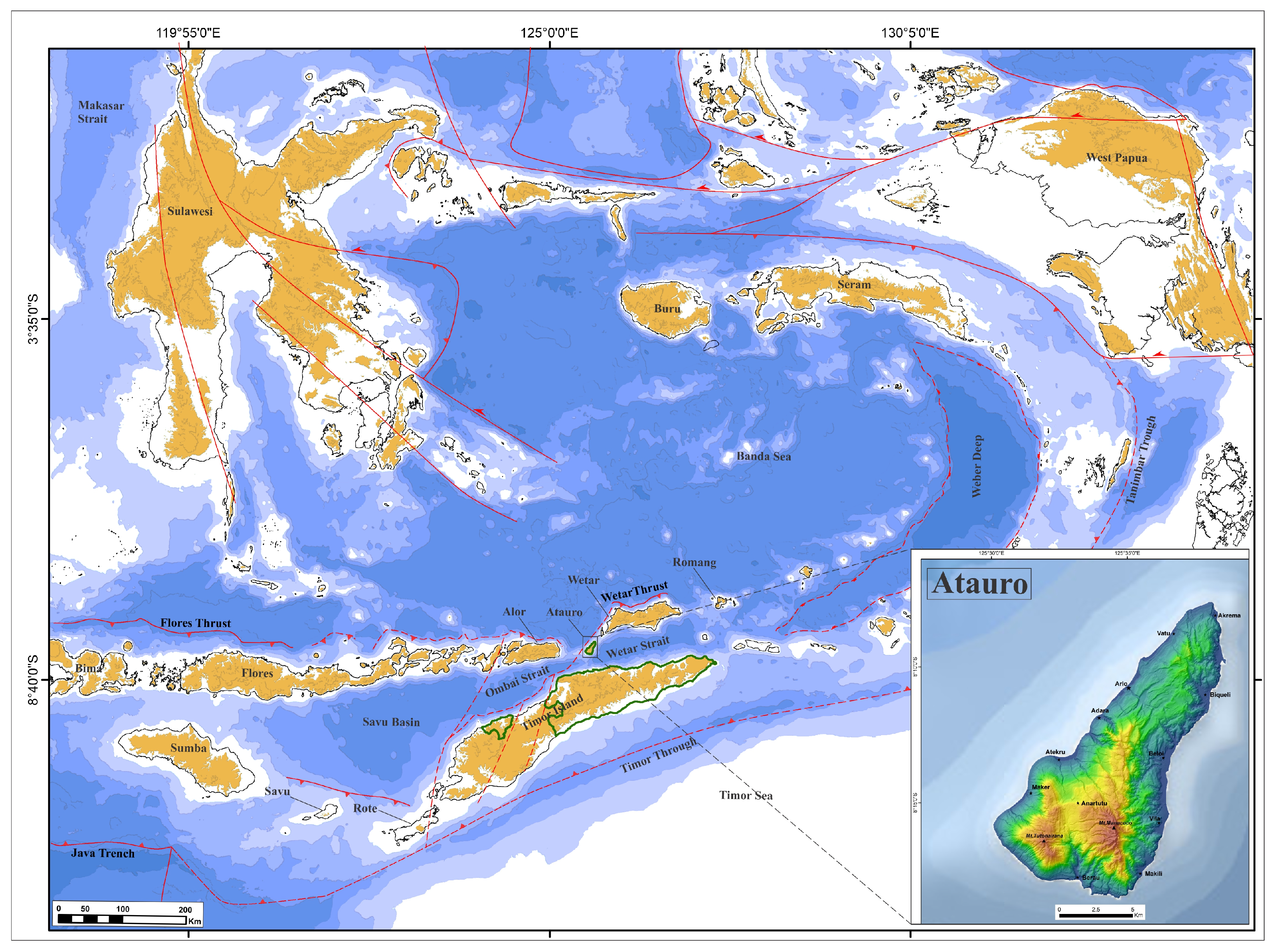
Understanding the geochemical framework of island arc systems, and its implications for mineral systems, is essential for advancing both academic research and applied exploration strategies [1,2,3,4,5,6]. Ataúro Island, situated within the inner Banda Arc (Figure 1), provides an exceptional natural laboratory to investigate the interplay between lithology, hydrothermal processes, and metal dispersion in a convergent-margin setting. Despite its small size (~140 km2), Ataúro displays remarkable lithological diversity—including basaltic to andesitic volcanic rocks, volcanic breccias, and dacitic domes—which collectively record the tectono-magmatic evolution of the Banda Arc [7,8,9,10,11,12].
Globally, island arcs host a wide spectrum of mineral systems, ranging from volcanogenic massive sulfide (VMS) to epithermal precious-metal deposits [13,14]. The Banda Arc is particularly significant because it combines subduction-related magmatism, arc–continent collision, and hydrothermal activity within a confined geological environment [15,16,17]. Neighboring islands such as Wetar and Damar are well known for polymetallic sulfide systems enriched in Cu, Zn, Pb, and precious metals, spatially associated with felsic intrusions and hydrothermal centers [18,19]. Within this regional context, Ataúro’s structural fabric—marked by NE–SW and NW–SE fault systems—and its well-developed radial drainage network play a crucial role in controlling hydrothermal fluid pathways and secondary element dispersion. Although less explored, Ataúro shares tectono-magmatic and hydrothermal characteristics with these Banda Arc islands, particularly the spatial association between felsic domes, fault-controlled fluid circulation, and polymetallic element assemblages. This regional framework therefore provides an essential comparative basis for assessing Ataúro’s hydrothermal evolution and evaluating the continuity of geochemical processes along the inner Banda Arc.
Although Ataúro has been the focus of petrological and geochronological investigations [7,9,11,12,20], no comprehensive island-scale geochemical baseline study has yet been undertaken. Ely et al. [11] documented its uplift and exhumation within the Banda Arc collision zone, while [6] and [21] provided fundamental tectonic syntheses. However, the processes linking magmatism, hydrothermal alteration, and oxidative weathering under humid tropical conditions remain poorly constrained, and the spatial organization of geochemical domains across the island is still insufficiently characterized.
Establishing island-scale geochemical baselines is therefore critical—not only for mineral exploration screening but also for environmental assessment and planetary-health research. Such baselines make it possible to discriminate between lithogenic, hydrothermal, and anthropogenic inputs, while providing valuable reference levels for medical and environmental geochemistry [22,23,24,25]. When integrated with structural and geomorphological factors—particularly fault systems and drainage networks that influence element dispersion and geochemical patterning—baseline data become powerful analytical tools. Combined with Compositional Data Analysis (CoDA), they allow robust statistical separation of lithogenic, hydrothermal, and supergene processes, minimizing closure effects and enhancing interpretability [26,27,28].
In Timor-Leste, where artisanal mining and geothermal projects are emerging, linking geochemical baselines with geological and geomorphological frameworks is essential to promote sustainable resource development and effective environmental management. This study addresses these knowledge gaps by presenting the first island-wide geochemical baseline for Ataúro Island, derived from stream-sediment sampling. Its objectives are to:
  • Establish a representative geochemical baseline across distinct lithological, structural, and geomorphological domains;
  • Integrate multi-element geochemistry, compositional data analysis, and geological information to define geochemical process domains relevant to hydrothermal circulation and metal dispersion within the Banda Arc framework.
In this context, the present study aims to establish the first island-wide geochemical framework of Ataúro Island by integrating multi-element geochemistry, compositional data analysis, geological information, and spatial distribution patterns. Rather than defining proven metallogenic systems or economic mineral deposits, this work focuses on identifying lithologically and structurally controlled geochemical associations and discussing their potential exploration relevance within an active arc–continent collision setting. The results provide a robust geochemical baseline and a first-order framework to support future targeted hydrothermal, mineralogical, and exploration-oriented studies in the region. In this study, the term “post-arc” is used in the sense of late-stage arc evolution during arc–continent collision and incipient extensional reorganization, rather than a fully post-subduction setting.

2. Geological Setting

Ataúro Island lies approximately 25 km north of Dili, the capital of Timor-Leste, within the inner Banda Arc (Figure 2). The island forms a steep volcanic edifice rising to more than 900 m at Mount Manucoco and represents an uplifted tectonic block formed during arc–continent collision, as documented in regional studies [1,14,16]. Its position between the volcanic front and the northern fore-arc ridge marks a transition from active subduction to incipient post-collisional extension, a tectonic setting widely recognized across the Banda Arc region [3,4,6].
Early geological investigations on Ataúro Island—including the classical works of [8,11]—recognized its predominantly volcanic character and the presence of interbedded carbonate sequences. The first systematic geological map of the island was produced by Ely et al. [10], who defined the main volcanic, volcaniclastic, and carbonate units and provided an initial structural framework. Subsequent studies on Banda Arc volcanism and hydrothermal systems [7,17,18] further contextualized Ataúro within the regional magmatic evolution, although these works were not focused specifically on the island.
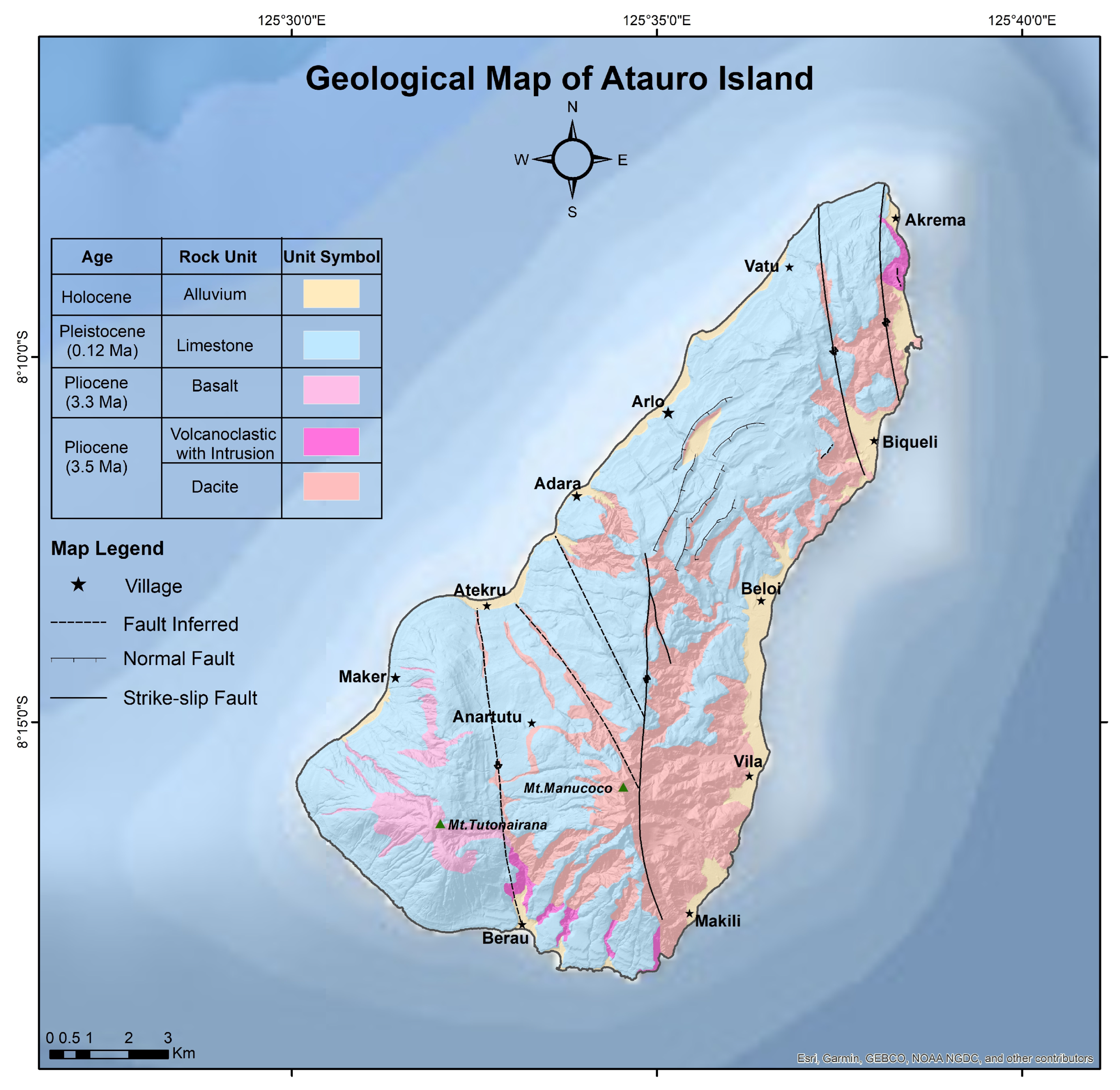
A major advance was achieved with the high-resolution geological map of Dos Santos et al. [12], which refines lithological boundaries and reveals a substantially denser network of NW–SE and NE–SW faults and shear zones than previously recognized (Figure 2). This updated structural interpretation highlights numerous deformation corridors that exert strong control on topography, drainage organization, volcanic centers, and hydrothermal fluid pathways.
The dominant lithologies of Ataúro (Table 1) include basaltic to andesitic lavas, volcanic breccias, and felsic domes, forming a bimodal volcanic succession characteristic of the inner Banda Arc [10,11,12]. Autobrecciated flows and volcaniclastic deposits are widespread, reflecting alternating effusive and explosive volcanic activity. Dacitic domes, interpreted as late-stage felsic centers, are locally associated with zones of hydrothermal alteration, including silicification, argillic alteration, and barite–sulfide veining. These features are consistent with epithermal-style hydrothermal alteration assemblages reported elsewhere in the Banda Arc region [14,20].
Carbonate units occur mainly along coastal and lower-elevation sectors, forming raised reef terraces and thin limestone lenses that record sea-level oscillations and syn-volcanic subsidence [8,12]. Although volumetrically limited, these carbonate units locally influence geochemical signatures at volcanic–carbonate interfaces.
Overall, the updated geological framework of Ataúro Island provided by Dos Santos et al. [12] offers the most detailed structural and lithological representation to date and forms a robust basis for interpreting the geochemical patterns discussed in this study.

3. Materials and Analytical Methods

3.1. Sampling Design and Geological Representativity

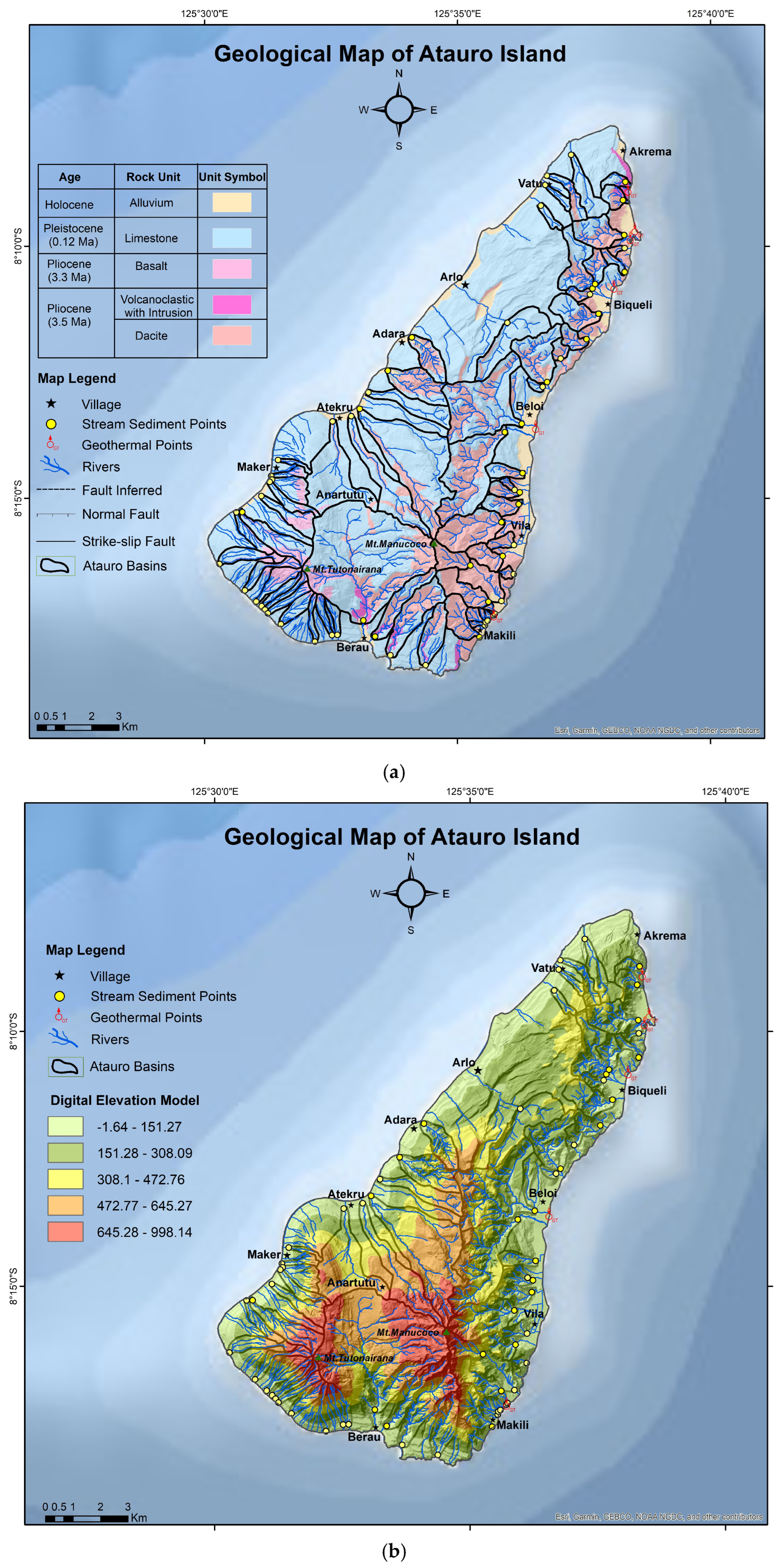
A total of 64 stream-sediment samples were collected across Ataúro Island, systematically covering the main lithological units (basaltic to andesitic volcanic rocks, volcanic breccias, dacitic domes, carbonates and alluvium) as summarized in Table 2 and shown in Figure 3a,b. Sampling was conducted along the main drainage network (up to third-order streams), ensuring balanced representation of lithological, geomorphological, and structurally controlled hydrothermal domains.
Each sample corresponds to the active fine fraction (<180 μm), collected from mid-channel positions to minimize sediment reworking and maximize geochemical representativity. Field observations included lithology, slope, drainage order, alteration features, and evidence of hydrothermal or oxidative–supergene processes. This design ensured robust coverage of both primary lithogenic signatures and secondary surface-weathering environments.
The sampling protocol follows the Global Geochemical Baselines (GGB) standards [22] and complies fully with the methodological framework of the IUGS–IAGC Global Geochemical Baselines Programme [23,24,25], enabling long-term comparability with regional and international reference datasets.
Structural and drainage datasets were integrated in ArcGIS 10.8 (Section 5) to evaluate the influence of fault systems, lithological boundaries, and hydromorphological controls on element dispersion, particularly within hydrothermal and supergene domains.
To avoid misinterpretation of lithology-controlled geochemical variability as metallogenic anomalies, Table 2 is intended to document the stratigraphic, lithological, and mineralogical representativity of the sampling design rather than to define anomalous metal concentrations. The elemental contents associated with each unit reflect expected background compositions linked to their dominant mineralogical assemblages and geological context.
Basaltic to andesitic lavas and volcaniclastic units are characterized by elevated Fe–Ti–Mg–Cr–Ni–Co contents, reflecting the abundance of ferromagnesian minerals such as clinopyroxene, amphibole, and Fe–Ti oxides. Dacitic domes and felsic volcaniclastic units display comparatively higher Ba–Sr–Pb–Ag signatures, consistent with feldspar-rich lithologies and accessory phases typical of evolved arc magmatism. Alteration zones are marked by As–Sb–Ag–Pb–S associations, compatible with silica–sericite alteration and barite–sulfide/sulfosalt mineral assemblages commonly reported in epithermal-style hydrothermal alteration settings. Carbonate and surficial units show Ca–Sr enrichment and Fe–Mn oxide phases related to supergene processes and incipient oxidative weathering.
Accordingly, Table 2 provides a lithological–mineralogical framework for interpreting the geochemical dataset and for distinguishing lithogenic background from hydrothermal and supergene overprints discussed in Section 5, rather than evidence of confirmed economic mineralization.

3.2. Laboratory Analytical Procedures

Samples were air-dried, sieved to <180 µm, homogenized, and split into aliquots prior to chemical analysis. Major and trace elements were quantified using complementary analytical techniques:
  • ICP-OES for major and transition metals;
  • ICP-MS for most trace and chalcophile elements;
  • INAA (Instrumental Neutron Activation Analysis) for selected elements, including As, Sb, Au, and REEs.
All analyses were performed at Activation Laboratories Ltd. (Actlabs, Ontario, Canada), accredited under ISO/IEC 17025 [29], following internal QA/QC procedures. Analytical quality control included certified reference materials, international geostandards, procedural blanks, and duplicates. Precision and accuracy were maintained within ±5% RSD for all elements, ensuring full analytical reliability.

3.3. Data Treatment and Statistical Workflow

All statistical and spatial analyses were conducted using JMP Pro 17 and ArcGIS 10.8. Geochemical datasets were processed following Compositional Data Analysis (CoDA) principles [26,27], and expanded by [28]. Values below detection limits were replaced using multiplicative lognormal substitution (<DL × 3/2), and datasets were closed to 100%. The Centered Log-Ratio (CLR) transformation was applied to mitigate closure effects and enable multivariate statistical interpretation [26,27,28].
Principal Component Analysis (PCA) was conducted on CLR-transformed data to identify element covariation patterns. PCA scores were subsequently interpolated using the Inverse Distance Weighting (IDW) algorithm in ArcGIS 10.8, visualizing geochemical gradients and identifying lithological or hydrothermal trends. IDW interpolation was used exclusively as a descriptive tool to visualize first-order, island-scale geochemical patterns and does not imply predictive continuity or local-scale interpolation of element concentrations. Overlay analysis was conducted by superimposing fault/fracture networks and drainage basins over the PC1–PC3 maps (see Discussion) to discriminate structural versus geomorphological influences on geochemical dispersion patterns.
In cases where the Median Absolute Deviation (MAD) equaled zero—indicating extremely low variability—the Interquartile Range (IQR) was adopted as an alternative robust measure of dispersion, following the approach of [29,30,31,32,33].
All samples were analyzed for a wide suite of major, trace, and rare-earth elements (REEs) using the combined analytical workflow described above. Although the complete dataset was processed using CoDA to evaluate global structure, only 16 representative elements were retained for the main statistical and spatial analyses. This selection was based on detection frequency, analytical reliability, and geochemical relevance to the island’s lithological framework.
The extended dataset, including additional trace elements and REEs, was likewise processed and is available in the Supplementary Materials, ensuring reproducibility and methodological transparency. References to supplementary figures are made in the Discussion section only when directly relevant to interpretations in the main text.

4. Results

4.1. Statistics

Table 3 presents the univariate descriptive parameters (minimum, maximum, mean, median, interquartile range [IQR], and median absolute deviation [MAD]) for all analyzed elements in their original, non-transformed form. These statistics provide a first-order overview of elemental ranges and dispersion prior to compositional treatment, allowing an initial assessment of variability among major, transition, and trace elements [22,31,32,33].
Major elements (Fe, Ti, Mg) display relatively narrow concentration ranges and low dispersion, confirming the internal consistency of the lithogenic background across the island. Sulfur (S), expressed in weight percent, shows moderate variability (IQR = 0.03%), suggesting contributions from both primary lithogenic sources and secondary processes. Vanadium (V) exhibits higher variability (IQR = 67 mg kg−1) than the major oxides, consistent with its behaviour as a redox-sensitive transition element.
Transition and chalcophile elements (Cr, Ni, Co, Cu, Zn, Pb, As, Sb, Ag, and Ba) are characterized by wide concentration ranges and elevated dispersion, reflecting heterogeneous distribution across distinct lithological, structural, and geomorphological settings. Gold (Au) is strongly left-censored at the analytical detection limit (median = 1.6 µg kg−1; MAD = 0), indicating that raw concentration values alone are insufficient to characterize its spatial behaviour.
Overall, the coexistence of elements with contrasting dispersion patterns highlights the limitations of direct univariate interpretation in closed geochemical datasets. This motivates the subsequent application of robust statistics (IQR, MAD) and compositional data analysis (CLR transformation), which are addressed in Section 4.2 and form the basis for multivariate interpretation [26,27,28,34,35].

4.2. Boxplots and Dispersion Structure After CLR Transformation

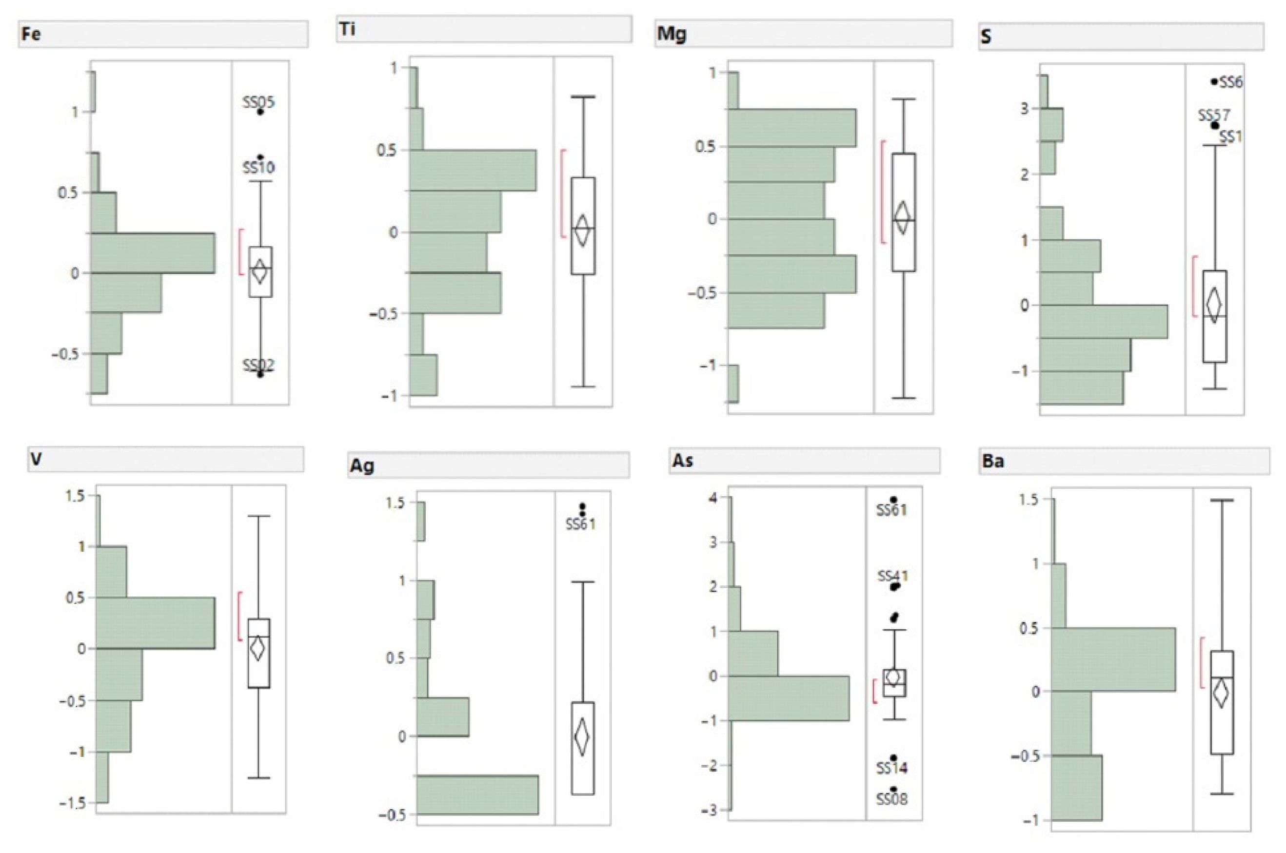
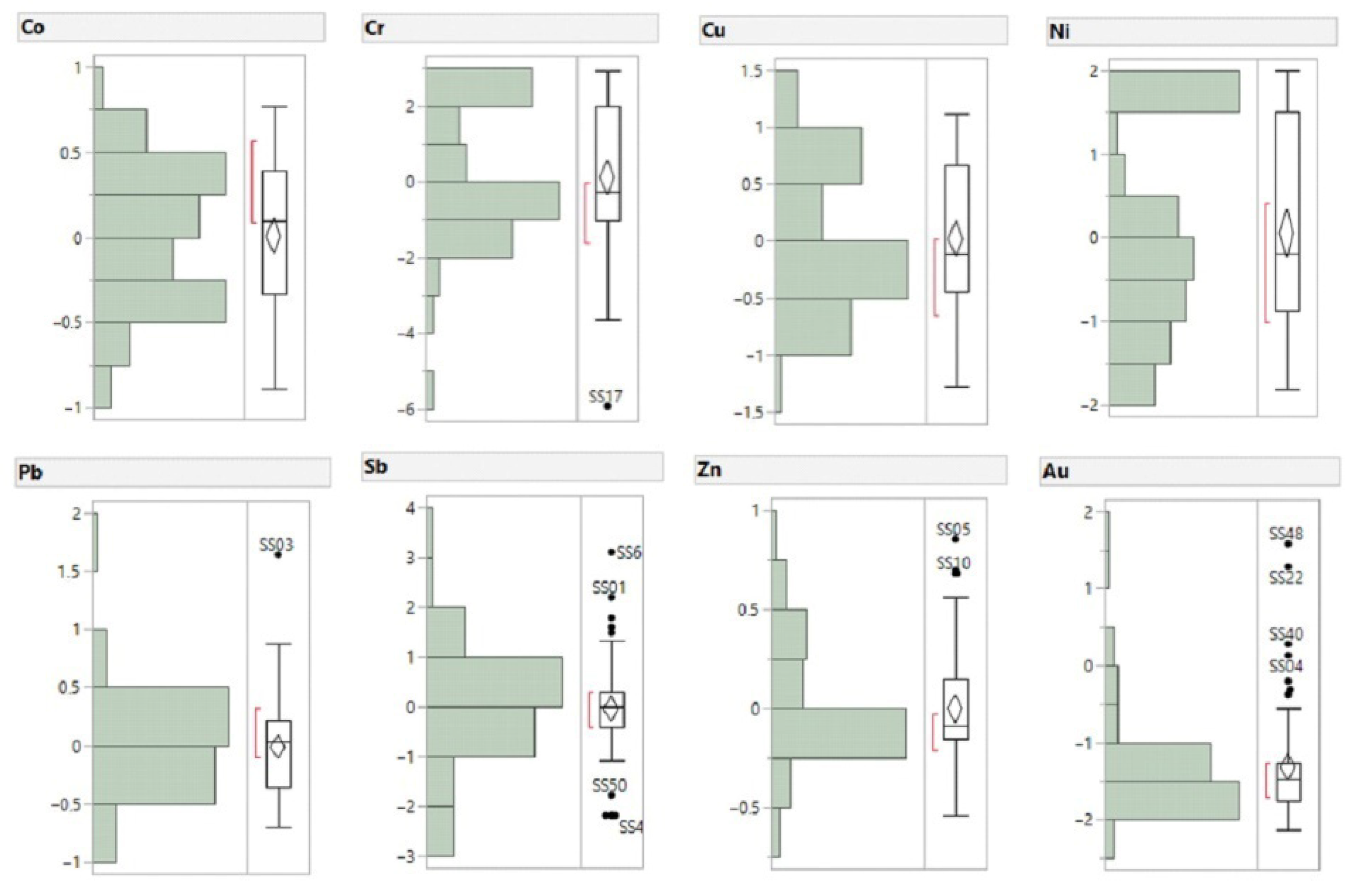
To avoid redundancy, this section focuses exclusively on boxplot interpretation after CLR transformation, emphasizing compositional behaviour and geochemical contrasts revealed by CoDA. The CLR-transformed boxplots (Figure 4) summarize the dataset after log-ratio normalization, allowing direct comparison with the univariate parameters presented in Table 3 [23,26,27,28]. This transformation removes the closure effect and places all variables on a common logarithmic scale, thereby expressing relative rather than absolute differences between elements.
After CLR transformation, major elements (Fe, Ti, Mg) display narrow, nearly symmetric boxplots with limited interquartile ranges and few outliers, indicating low relative dispersion and internally consistent compositional behaviour. This pattern reflects their dominant lithogenic control and homogeneous distribution across the main volcanic units of the island.
Sulfur (S), although expressed as a major element, shows a wider interquartile range and moderate positive skewness in CLR space, highlighting its transitional compositional behaviour between major oxides and chalcophile elements. This dispersion pattern is consistent with mixed lithogenic–hydrothermal contributions and variable mobility under near-surface conditions. Vanadium (V) exhibits intermediate dispersion, bridging the behaviour of Fe-bearing phases and trace-element associations, confirming its dual affinity with lithogenic and redox-sensitive processes.
Trace elements (Ag, As, Ba, Co, Cr, Cu, Ni, Pb, Sb, and Zn) are characterized by broader CLR boxplots and pronounced upper tails extending beyond Q3 + 1.5 IQR, indicating heavy-tailed distributions and relative enrichment in a limited number of samples. Chromium and arsenic show the strongest asymmetry, with elongated upper whiskers reflecting heterogeneous compositional behaviour related to lithological control and localized hydrothermal or supergene overprinting.
Gold (Au) presents a compressed lower-range box with a small number of discrete high CLR values, reflecting a censored population dominated by concentrations near the analytical detection limit, punctuated by relative enrichments in structurally and lithologically favourable settings. This behaviour is typical of noble metals in regional-scale geochemical surveys and supports interpretation in terms of geochemical footprints rather than economic concentrations.
Overall, the coherence between univariate statistics and CLR-transformed boxplots confirms the hierarchical scale structure of the dataset and validates the application of multivariate compositional techniques in subsequent analyses [26,27,28,36].

4.3. Compositional Data Analysis (CoDA–PCA)

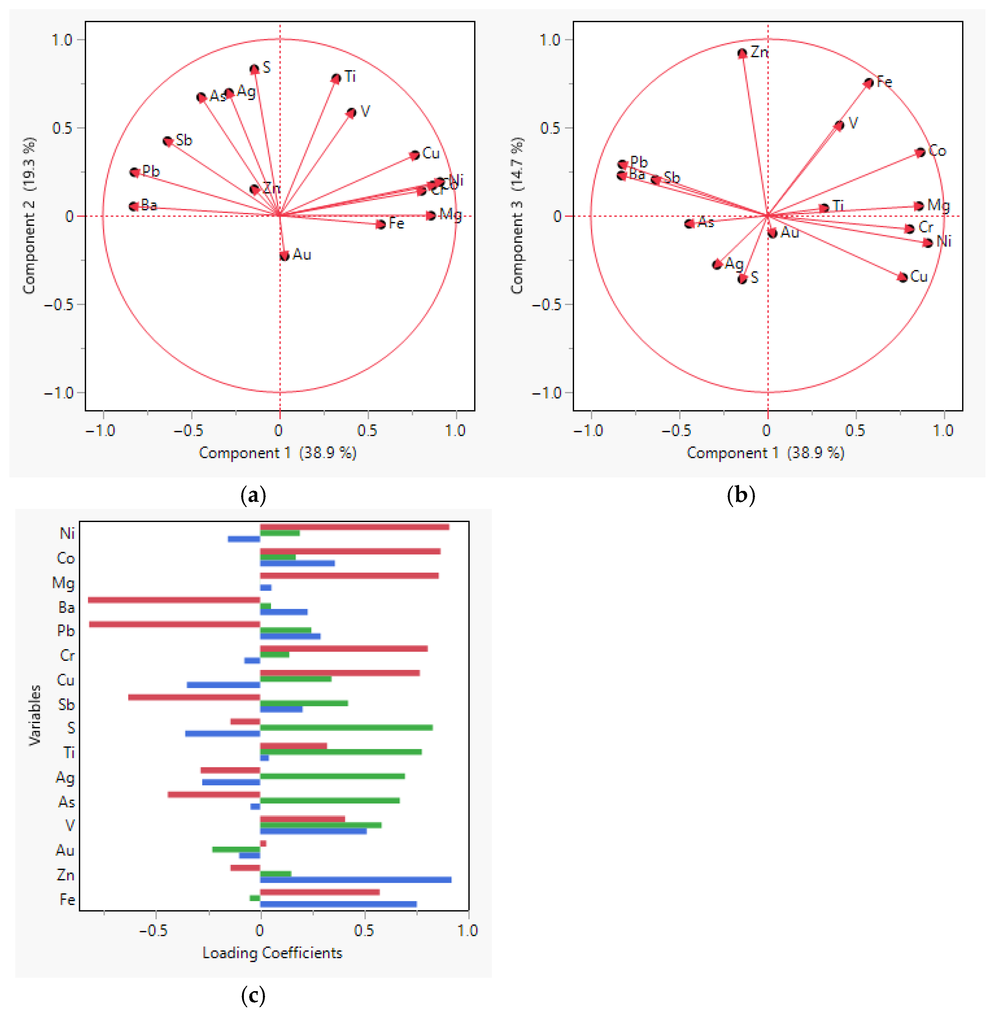
The CoDA–CLR analysis identified the principal patterns of covariation among the analyzed elements. The first three principal components (Figure 5a–c) explain 73% of the total variance (PC1 = 38.9%, PC2 = 19.3%, PC3 = 14.7%) [26,27], consistent with previous applications of CoDA in regional geochemical datasets [28].
The biplots define three statistically coherent compositional gradients. PC1 groups Fe, Ti, Mg, Cr, Ni, Co, and Cu in strong positive correlation, representing the dominant lithogenic compositional trend associated with mafic to intermediate volcanic rocks. PC2 isolates Pb, As, Sb, Ag, and Au as a largely orthogonal association to PC1, reflecting an independent chalcophile–semimetal covariance structure commonly reported in hydrothermal systems [36,37]. PC3 accounts for 14.7% of the variance and is dominated by Zn, Fe, and V, defining an additional oxidative or supergene-related compositional dimension.
Loading coefficients confirm that most variance is concentrated in PC1 and PC2, supporting the internal consistency and robustness of the PCA–CLR model [34,35]. Two principal compositional axes are thus defined: a lithogenic axis (Fe–Ti–Mg–Ni–Co–Cr) and a chalcophile–semimetal axis (As–Sb–Pb–Ag–Au). Gold (Au) shows moderate loadings on both PC2 and PC3, indicating dual but non-dominant participation and suggesting overlapping hydrothermal and near-surface oxidative influences within the same compositional framework.

4.4. Spatial Distribution of PCA–CLR Scores

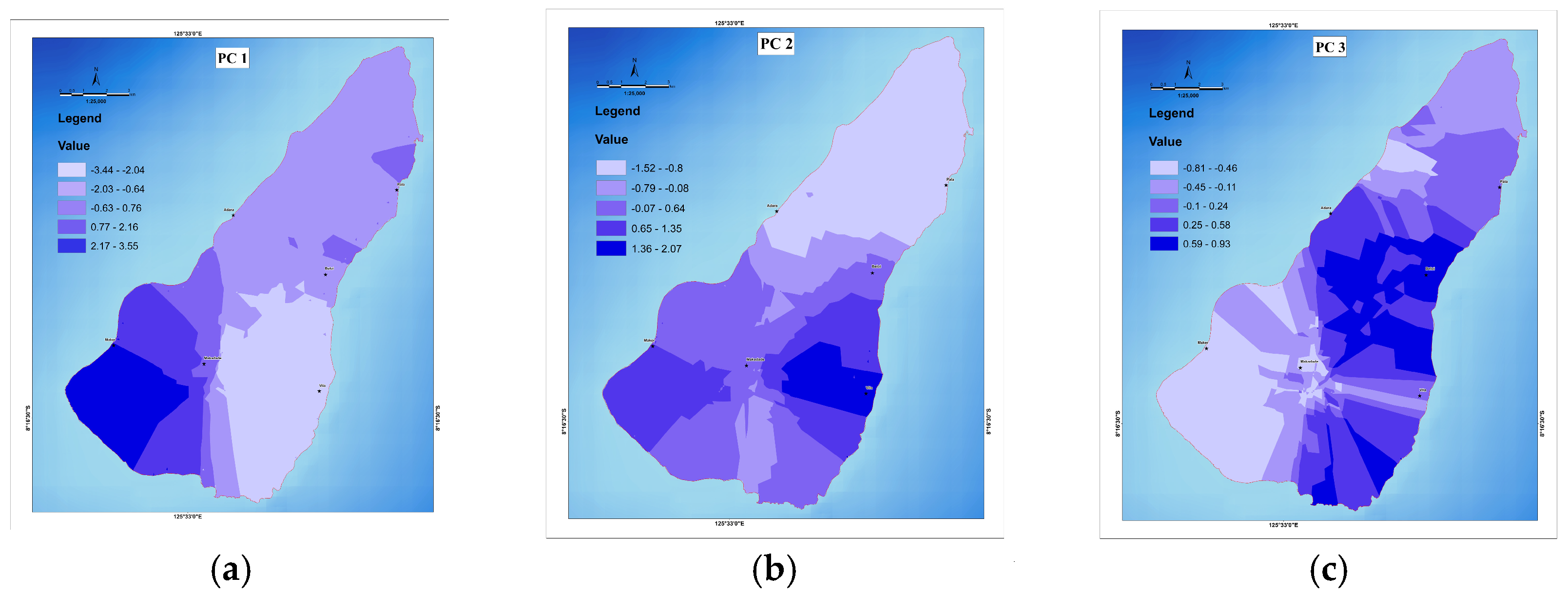
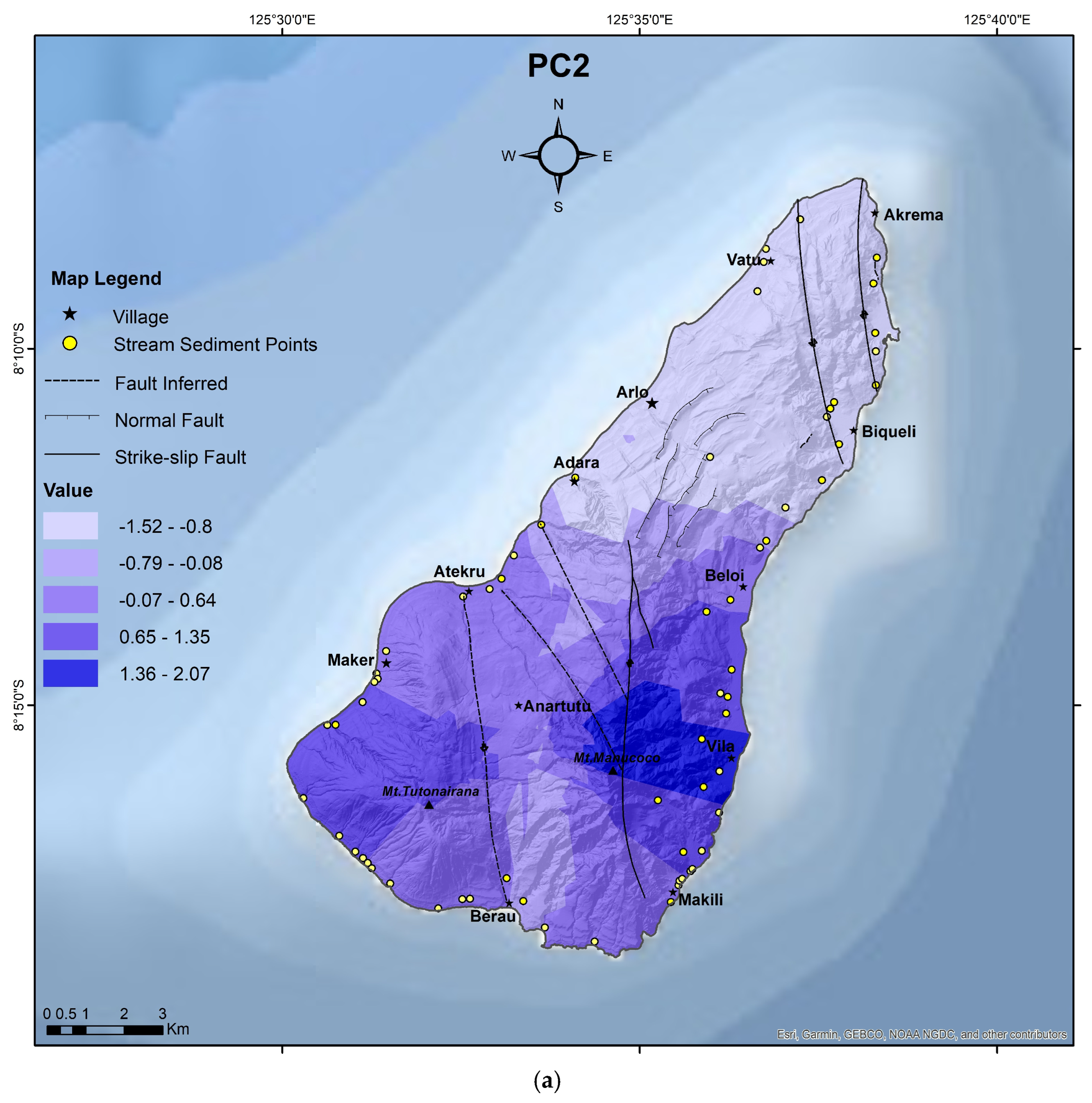
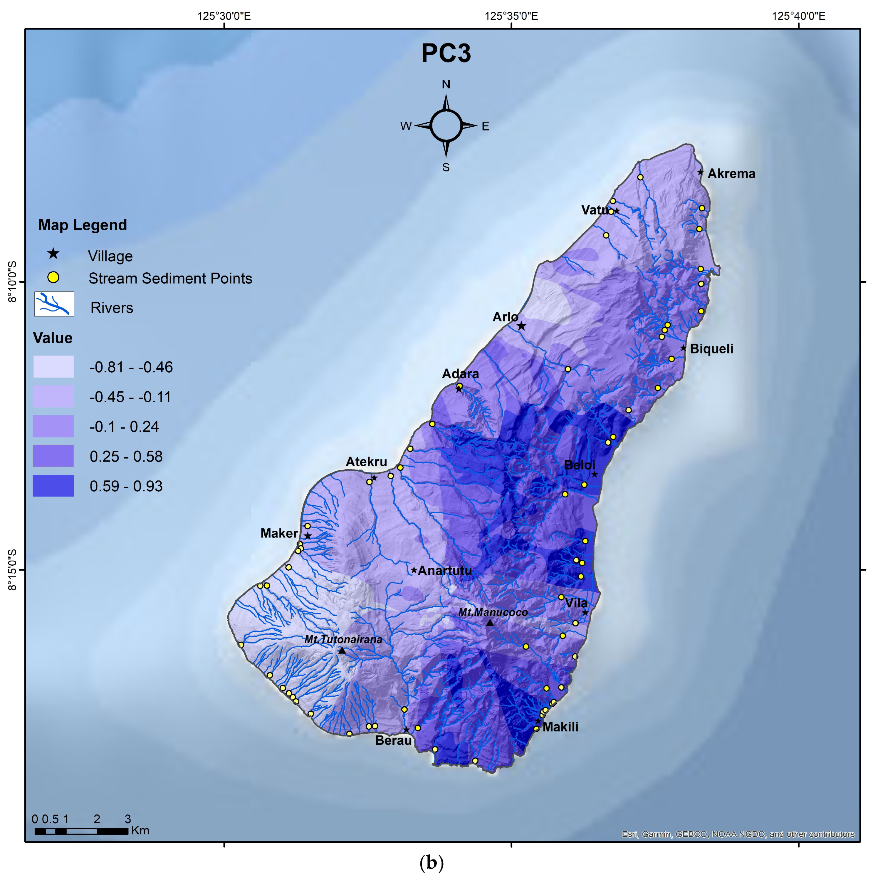
Interpolated PCA–CLR score maps (scale 1:25,000) display continuous and spatially coherent gradients across Ataúro Island (Figure 6). PC1, mainly defined by high positive loadings of Fe, Mg, Cr, Ni, and Co, shows the highest scores in the southern sector, gradually decreasing northwards and outlining a consistent south–north lithogenic gradient. PC2, characterized by positive loadings of Cu, Pb, Zn, As, Sb, Ag, and Au, delineates localized positive zones in the central and southeastern parts of the island, where elongated anomalies coincide with major fault alignments and structurally controlled corridors. PC3, dominated by Fe, V, and Zn, exhibits diffuse but coherent patterns concentrated in intermediate-relief terrains and drainage convergence zones.
Inverse Distance Weighting (IDW) interpolation was applied exclusively for visualization of first-order geochemical gradients and does not imply predictive continuity at the local scale. The spatial distribution of PCA–CLR scores is internally consistent with the corresponding loading structures, demonstrating the robustness of the multivariate compositional model.

4.5. Individual Anomaly Maps

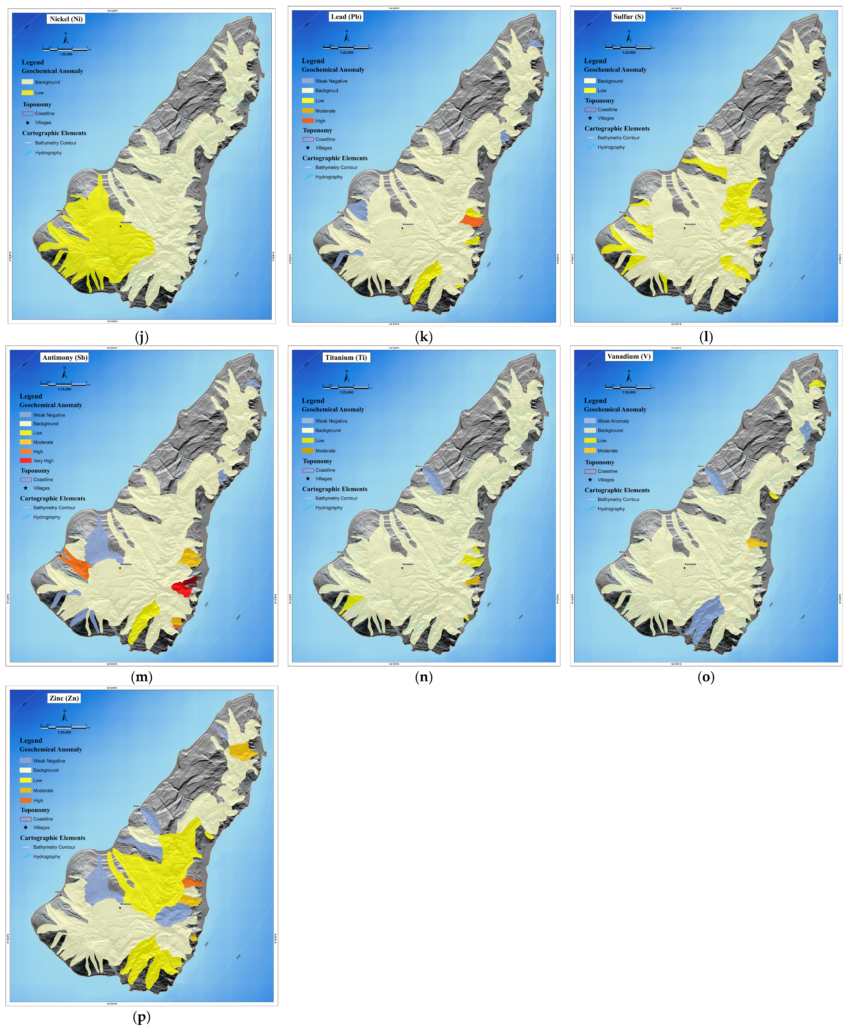
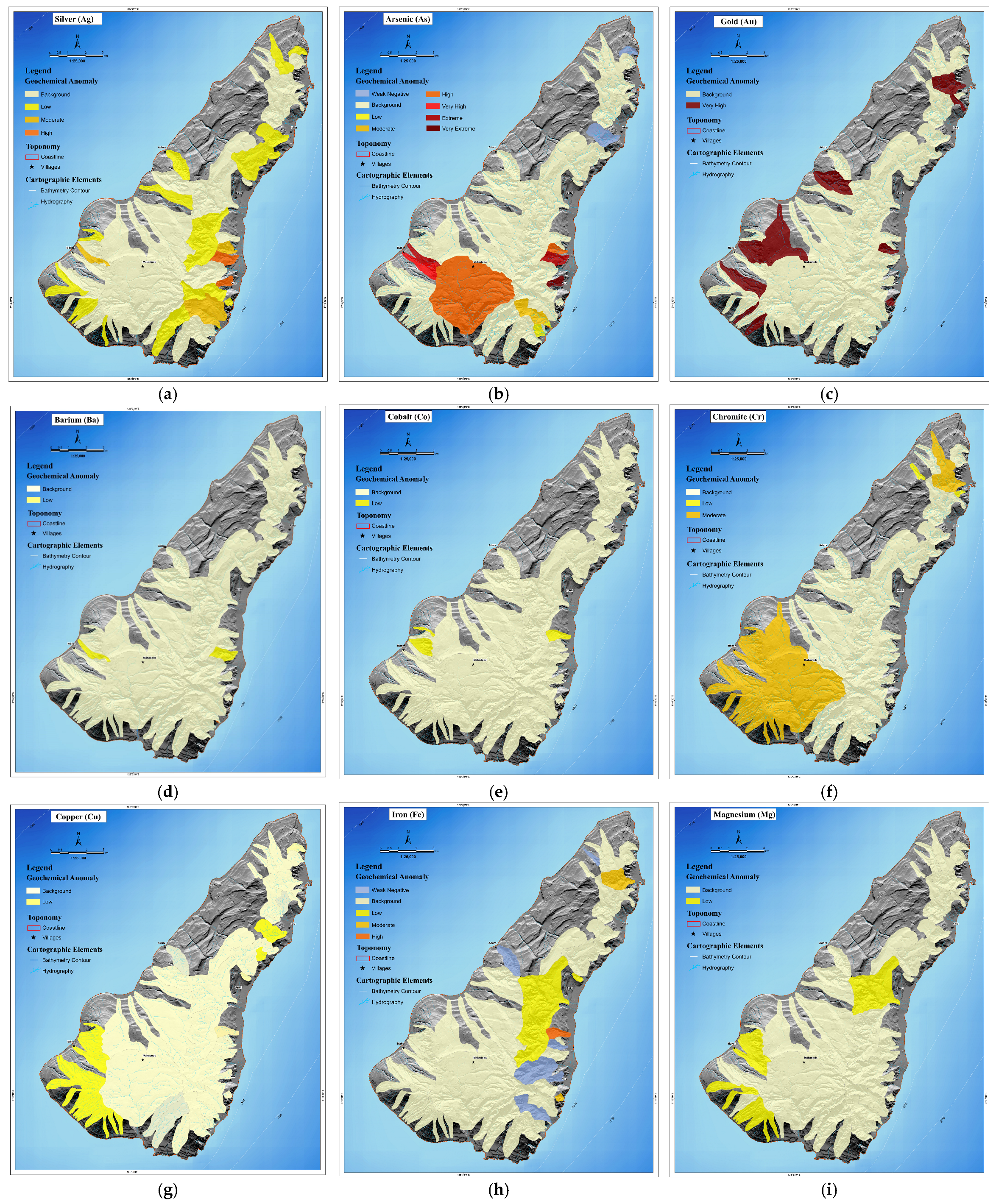
Sixteen elements (Fe, Ti, Mg, V, Cr, Ni, Co, Cu, Zn, Pb, As, Sb, S, Ag, Ba, and Au) were mapped individually using CLR-transformed data. Elemental concentrations were standardized into five anomaly classes (background to very high) based on robust MAD and IQR thresholds. A uniform color scale and consistent base cartography (1:25,000) were adopted to ensure spatial comparability across maps.
The resulting multi-panel presentation (Figure 7a–p) reveals coherent anomaly patterns that are consistent with the PCA-derived compositional structure. Due to strong data skewness, equal-interval or percentile-based classifications tend to suppress low but statistically meaningful Au variations. Although CLR transformation mitigates this effect, the contrast between background concentrations (1.6 µg kg−1) and higher values (>10 µg kg−1) produces apparent spatial gaps that reflect data sparsity rather than true compositional absence.

4.6. PCA–Anomaly Synthesis

Integration of PCA–CLR score maps (Figure 6) with individual anomaly maps (Figure 7) reveals strong spatial coherence between multivariate and univariate representations. High PC1 scores correspond to enrichment in Fe, Ti, Mg, Ni, Co, and Cr; high PC2 scores correspond to As, Sb, Pb, Ag, S, and Au associations; and PC3 variability corresponds primarily to Zn–Fe–V groupings. These relationships demonstrate that the PCA components accurately capture the dominant compositional gradients present in the dataset and provide a statistically robust basis for subsequent process-oriented interpretation.

5. Discussion

5.1. Lithogenic Control and Primary Geochemical Framework

The first principal component (PC1) expresses the lithogenic gradient that dominates the geochemical structure of Ataúro. It differentiates basaltic to andesitic volcanic units enriched in Fe, Ti, Mg, Ni, Co and Cr, a pattern consistent with global arc-magmatic trends described by [7,16,20], from felsic volcanic rocks (dacites, volcaniclastic tuffs, rhyolitic derivatives) enriched in Ba, Sr, Pb and Ag. This contrast reflects the island’s bimodal magmatic evolution also documented in regional Banda Arc studies by [7,10,11], confirming that PC1 captures the primary magmatic signature.
Spatially, the PC1 score map (Figure 6a) delineates a consistent south–north compositional transition, with the highest Fe–Mg–Cr–Ni–Co values occurring in the southern to south-central volcanic breccia–lava domains and progressively lower values toward the northern and northeastern felsic sectors. This trend agrees with the volcanic succession mapped by [10] but is now refined by the higher-resolution geological and structural boundaries introduced by [12], which demonstrate that the mafic–intermediate volcanic units extend farther east and west than previously recognized. This updated geometry better explains the continuity of the PC1 high-score corridor.
Along the eastern margin, Quaternary limestones enriched in Ca and Sr contribute local geochemical mixing between volcanic and carbonate sources. This influence appears in the intermediate Ca–Ba–Sr loadings of the PCA and is consistent with carbonate overprinting along volcanic–carbonate transition zones identified in the new geological mapping of [12].
To refine the lithogenic interpretation, a supplementary PCA including Ca, Sr, P and rare-earth elements (REE = La, Ce, Nd, Sm, Dy, Yb, Y) shows that light REE (La–Sm) cluster with Ba and Sr toward the felsic end-member, matching patterns described in felsic arc magmatism [13,14]. In contrast, heavy REE (Yb, Y) and P plot in intermediate positions between carbonate and mafic vectors, suggesting contributions from accessory minerals such as apatite, monazite and xenotime—behaviour consistent with REE distribution models in arc settings [13,14]. These relationships are further illustrated by the extended PCA–CLR biplots and loading coefficients presented in the Supplementary Material (Figures S2 and S3; Tables S1 and S2), which support the lithogenic differentiation and volcanic–carbonate mixing identified in the main dataset.
Geochemical–mineralogical relationships further support the interpretation of the main components. The mafic association (Fe–Ti–Mg–Ni–Cr–Co) is consistent with the dominance of ferromagnesian phases (pyroxene, amphibole) and Fe–Ti oxides in basaltic–andesitic units, whereas the felsic end-member (Ba–Sr–Pb–Ag) is compatible with evolved feldspar-rich lithologies and accessory phases typical of dacitic centers. In the altered domains, the As–Sb–Ag–Pb–S association matches the presence of hydrothermal alteration minerals (silica/sericite) and barite–sulfide/sulfosalt assemblages reported for epithermal-style systems, while the near-surface Fe–V–Zn pattern is consistent with adsorption and co-precipitation onto Fe–Mn oxyhydroxides during incipient oxidative weathering.

5.2. Rare Earth Elements (REE) Signatures and Geotectonic Implications

Rare earth element (REE) data presented in the Supplementary Material are discussed here to support the geotectonic interpretation of the volcanic sequences and to contextualize the geochemical framework identified across Ataúro Island. REE patterns and PCA–CLR outputs (Supplementary Figures S2 and S3; Tables S1 and S2) show distinct signatures associated with mafic and felsic lithologies, reflecting the bimodal volcanic nature of the island. Mafic units display relatively flat to slightly light-REE-enriched patterns, consistent with basaltic magmatism in subduction-related to post-collisional arc settings [7,16].
Felsic volcanic and volcaniclastic units show stronger light-REE enrichment, magmatic differentiation and evolved melt compositions, consistent with indicating feldspar fractionation and crustal involvement during magma evolution. These REE systematics are consistent with volcanic arc environments developed during arc–continent collision processes in the Banda Arc [7,13,14,16].
Overall, the REE signatures confirm that the primary geochemical domains identified across Ataúro Island are largely controlled by lithological and magmatic differentiation processes rather than direct evidence of ore-forming hydrothermal mineralization. In the PCA–CLR framework, REE are dominantly associated with the lithogenic component (PC1) and show no systematic coupling with the hydrothermal vector, reinforcing their role as tracers of primary magmatic sources and volcanic–carbonate mixing. Nevertheless, these REE patterns provide a robust geotectonic framework within which potential metallogenic implications can be evaluated in future targeted studies aimed at distinguishing lithogenic from hydrothermal contributions [13,14].

5.3. Hydrothermal Vector and Epithermal-Style Geochemical Enrichment

The second principal component (PC2) captures the hydrothermal signature defined by the coherent association of As, Sb, Pb, Ag, Au, and S. These chalcophile and semimetal elements are commonly associated with geochemical halos developed in acid-sulfate epithermal systems [13,38], and their high loadings and positive scores indicate zones affected by hydrothermal fluid–rock interaction.
Within the geochemical framework established above, PC2 highlights hydrothermal-related element associations indicative of fluid–rock interaction and epithermal-style geochemical enrichment. The coherence of the PC2 hydrothermal association is further supported by the extended PCA–CLR results shown in Supplementary Figures S2 and S3 and Tables S1 and S2.
The updated PC2 score map with structural overlay (Figure 8a) shows that the highest As–Sb–Ag–Au values spatially coincide with a dense network of NW–SE and NE–SW fault corridors, consistent with the revised geological mapping. These patterns indicate that fault-controlled permeability played a key role in guiding hydrothermal fluid ascent and associated geochemical dispersion, particularly within altered volcanic tuffs and breccias.
Localized Cu–Zn–Pb–As–Sb–Ag enrichments occur where drainage networks intersect major fault zones, suggesting partial redistribution of hydrothermal signatures by surface processes [39,40,41,42,43,44,45,46,47]. The transitional behaviour of Cu and Zn between the lithogenic (PC1) and hydrothermal (PC2) components reflects mixed magmatic–hydrothermal inputs and partial remobilization during late-stage fluid circulation in shallow crustal settings [39].
Gold does not dominate the hydrothermal component but displays moderate positive loadings together with Ag–As–Sb–S, consistent with deposition under intermediate-sulfidation epithermal conditions and minor remobilization along structurally controlled pathways. These hydrothermal associations show compositional affinities with epithermal systems described in the Wetar–Timor sector of the Banda Arc.
Overall, the magnitude and spatial coherence of the As–Sb–Ag–Au–Pb associations indicate significant hydrothermal geochemical enrichment controlled by volcanic lithology and fault architecture. These patterns are interpreted as epithermal-style geochemical signatures, forming part of the broader geochemical framework of Ataúro Island, and provide relevant context for future exploration-oriented investigations, rather than evidence of confirmed mineralization.

5.4. Supergene Redistribution and Oxidative Weathering Overprint

The third component (PC3) highlights the influence of supergene oxidation and near-surface weathering processes, dominated by Fe, V, and Zn. These elements are sensitive to redox variations and secondary mobility under humid tropical conditions [48,49,50]. The PC3 map with hydromorphological overlay (Figure 8b) shows Fe–V–Zn enrichment following drainage convergence and valley-floor accumulation zones, supporting a hydrological rather than structural control on near-surface metal redistribution [49]. The supergene–oxidative component defined by PC3 is consistent with the extended PCA–CLR loadings presented in the Supplementary Material (Figures S2 and S3; Tables S1 and S2), where Fe–V–Zn show strong affinity with near-surface redistribution processes.
Although fully developed lateritic profiles are unlikely given Ataúro’s steep relief and young volcanic age, these patterns indicate incipient oxidative weathering and Fe-oxide precipitation in low-relief catchments, consistent with humid-island oxidative–supergene processes rather than mature laterite formation. The Fe–V–Zn pattern reflects oxidative mobilization, where Fe and V form secondary oxides and Zn is partly adsorbed onto Fe–Mn oxyhydroxides [50,51,52,53].
This distribution represents an early oxidative–supergene overprint, characteristic of humid island environments within the Banda Arc, marking the final stage of Ataúro’s near-surface geochemical evolution.

5.5. Geochemical Zonation and Regional Context Within the Banda Arc

Integration of PCA–CLR score maps, element anomalies, and structural–hydromorphological overlays (Figure 6, Figure 7 and Figure 8) reveals three main geochemical domains with distinct lithogenic, hydrothermal, and supergene signatures across Ataúro Island, consistent with the updated geological and structural framework [12]. These domains are defined strictly on geochemical criteria and reflect the combined influence of volcanic lithology, magmatic differentiation, structural permeability, and surface modification processes, rather than proven metallogenic provinces. Nevertheless, the identified patterns provide exploration-relevant geochemical frameworks that warrant further targeted investigation.
  • Northern felsic domain (Vila–Beloi–Pala): epithermal-style geochemical signature.
Characterized by enrichment in Au–Ag–As–Sb–Pb, reflecting epithermal-style geochemical associations spatially linked to dacitic domes, altered tuffs, and felsic volcaniclastic units [13,14,37,38,39,41,45,46]. These felsic centres occur near intersections of NW–SE and secondary NE–SW fault sets, enhancing fracture permeability and favouring hydrothermal fluid circulation [12,41,46]. Local interaction with carbonate units along the eastern margin contributes minor Sr–Ca geochemical overprinting but does not obscure the dominant felsic-related hydrothermal signature [12,24,25].
Importantly, the observed Au–Ag–As–Sb–Pb enrichments are interpreted as geochemical expressions of fluid–rock interaction within felsic volcanic systems, rather than as evidence of ore-grade mineralization. Absolute Au concentrations remain subeconomic (<1 ppm), and no mineralogical or structural evidence of preserved ore bodies has been identified.
Accordingly, this northern felsic domain is best interpreted as an area of epithermal-style geochemical enrichment with exploration significance, but not as a confirmed metallogenic province. Its relevance lies in defining structurally controlled geochemical conditions that may guide future, more targeted investigations (e.g., rock-chip sampling, mineral chemistry, and fluid-inclusion studies).
  • Central hydrothermal–epithermal corridor (Maquedade–Makili–Maumeta–Adara).
The central sector of Ataúro Island defines a structurally focused hydrothermal–epithermal-style geochemical corridor, characterized by coherent enrichments in Ag, As, Sb, S and subordinate Au, locally associated with Cu–Zn–Pb. This domain is spatially aligned with the main NW–SE fault systems and their intersections with secondary NE–SW transfer structures [12].
Drainage convergence locally enhances Fe–V–Zn concentrations, indicating that early oxidative–supergene processes partially overprint the hydrothermal signal. These secondary modifications redistribute pre-existing hydrothermal signatures rather than generate independent enrichment zones [47,48,49,50].
Overall, the Maquedade–Makili–Maumeta–Adara corridor represents a hydrothermal–epithermal-style geochemical domain, controlled by volcanic lithology and structural architecture, not a proven metallogenic corridor.
  • Southern mafic volcanic–volcaniclastic domain (Maulau–Maka).
Elevated Cr–Ni–Co values represent natural background levels controlled by petrography and mineralogy, rather than hydrothermal enrichment or metallogenic processes [7,16,22,23,24,25]. PCA confirms this interpretation, as these elements cluster strongly within PC1, the lithogenic component, and show no systematic coupling with chalcophile or semi-metal associations.
Supergene modification is limited due to steep relief and high erosion rates. Minor Fe–V–Zn redistribution reflects incipient oxidative weathering rather than lateritic enrichment or secondary metal concentration [47,48,49,50].
This southern mafic domain therefore constitutes a robust geochemical baseline, essential for discriminating lithogenic background from hydrothermal signals elsewhere on the island.

5.5.1. Northern Felsic Domain (Vila–Beloi–Pala): Epithermal-Style Geochemical Signature

The northern sector of Ataúro Island (Vila–Beloi–Pala) is characterized by a felsic volcanic assemblage dominated by dacitic domes and felsic volcaniclastic deposits, as defined by the updated geological mapping [10,11,12]. This domain exhibits relative enrichment in Au–Ag–As–Sb–Pb, which is spatially associated with felsic lithologies and zones of structural complexity rather than with proven mineral deposits.
These element associations correspond to geochemical signatures commonly reported in epithermal environments developed in volcanic arc and post-collisional settings [13,14,37,38,45,46]. However, in the case of Ataúro, the observed enrichments are interpreted as epithermal-style geochemical expressions reflecting fluid–rock interaction and element mobility along permeable structural zones, rather than direct evidence of ore-grade mineralization.
Structural analysis further indicates that these geochemical enrichments are preferentially aligned along NW–SE and subsidiary NE–SW fault systems, which acted as conduits for hydrothermal fluids during late-stage volcanic and post-collisional deformation [12,41,46]. Nevertheless, the magnitude of the observed Au concentrations remains subeconomic, and no direct mineralogical evidence of ore bodies has been identified.
Accordingly, this northern felsic domain is best interpreted as an area of epithermal-style geochemical enrichment with exploration significance, but not as a confirmed metallogenic province. Its importance lies in defining a structurally controlled geochemical framework that may guide future, more targeted investigations (e.g., rock-chip sampling, mineral chemistry, and fluid-inclusion studies) aimed at discriminating lithogenic, hydrothermal, and potential ore-forming processes.

5.5.2. Central Hydrothermal–Epithermal Corridor (Maquedade–Makili–Maumeta–Adara)

The central sector of Ataúro Island, encompassing the Maquedade–Makili–Maumeta–Adara area, defines a structurally focused hydrothermal–epithermal-style geochemical corridor characterized by coherent enrichments in Ag, As, Sb, S and subordinate Au, locally associated with Cu–Zn–Pb. This domain is spatially aligned with the main NW–SE fault systems and their intersections with secondary NE–SW transfer structures, as revealed by the updated geological map and structural framework [12].
Copper and zinc show transitional behaviour between the lithogenic (PC1) and hydrothermal (PC2) components, suggesting mixed magmatic–hydrothermal inputs and partial remobilization during late-stage fluid circulation. This geochemical overlap is typical of shallow hydrothermal systems operating in extensional to post-collisional arc settings, where magmatic fluids interact with meteoric waters along fault-controlled pathways [37,38,39,40].
Tthe Maquedade–Makili–Maumeta–Adara corridor represents a hydrothermal–epithermal-style geochemical domain controlled by volcanic lithology and structural architecture, rather than a proven metallogenic province. The spatial continuity, multi-element coherence and structural alignment of this domain nevertheless provide a robust geochemical framework for future, more targeted investigations aimed at distinguishing lithogenic, hydrothermal and supergene contributions at finer spatial and mineralogical scales.

5.5.3. Southern Mafic Volcanic–Volcaniclastic Domain (Maulau–Maka)

The southern sector of Ataúro Island, encompassing the Maulau–Maka area, defines a mafic volcanic–volcaniclastic geochemical domain characterized by systematically high concentrations of Fe, Ti, Mg, Ni, Co and Cr. This elemental association reflects the primary lithogenic signature of basaltic to andesitic lavas and associated volcaniclastic units, consistent with arc-related magmatism in the Banda Arc [7,8,9,11,12,16].
Unlike the northern and central domains, the geochemical patterns observed in this southern sector are not indicative of hydrothermal or epithermal-style enrichment. Instead, elevated Cr–Ni–Co values represent natural background levels controlled by the petrographic and mineralogical composition of mafic volcanic rocks, including clinopyroxene-, amphibole- and plagioclase-bearing assemblages. Such element distributions are expected in bimodal volcanic systems and do not imply metallogenic mineralization [7,16,22,23,24,25].
Principal Component Analysis further supports this interpretation, as the dominant loadings of Fe–Ti–Mg–Ni–Co–Cr cluster strongly within PC1, the lithogenic component. The absence of systematic coupling between these elements and chalcophile or semimetal associations (e.g., As, Sb, Ag, Au, S) confirms that hydrothermal inputs are negligible in this domain.
Supergene modification is limited in the Maulau–Maka sector due to steep relief, high erosion rates and the lack of thick regolith development. Although minor Fe–V–Zn redistribution is locally observed along drainage channels, these features reflect incipient oxidative weathering rather than lateritic enrichment or secondary metal concentration [47,48,49,50].
Consequently, the southern mafic domain constitutes a robust geochemical baseline against which hydrothermal and epithermal-style signatures in the northern and central sectors can be evaluated. While not representing an economic target, this domain provides an important natural reference for critical-metal distribution in mafic arc volcanic successions within humid island environments of the Banda Arc [7,8,9,11,12,22,23,24,25].

6. Conclusions

This study establishes the first comprehensive geochemical baseline and integrated geochemical framework for Ataúro Island, providing new insights into post-arc geochemical system evolution in the eastern segment of the Banda Arc. Through CoDA–CLR–PCA integrated with updated geological, structural, and hydromorphological information, the island’s geochemical architecture is shown to result from the superposition of lithogenic, hydrothermal, and oxidative–supergene processes.
The lithogenic framework, defined by Fe–Ti–Mg–Ni–Co–Cr, reflects the primary geochemical signature of basaltic to andesitic volcanic rocks and associated volcaniclastic successions and represents the dominant background control on elemental distribution.
The hydrothermal vector, dominated by Ag–As–Sb–S–Au, highlights structurally controlled hydrothermal–epithermal-style geochemical enrichment, interpreted as geochemical footprints of fluid–rock interaction and metal dispersion rather than evidence of economic mineralization.
The oxidative–supergene overprint, expressed through Fe–V–Zn redistribution, records incipient near-surface weathering under humid tropical conditions, locally modifying earlier lithogenic and hydrothermal signatures.
Together, these processes define three distinct geochemical domains aligned with major NW–SE fault systems. Although gold concentrations remain subeconomic (<1 ppm), the presence of coherent transition-element halos is consistent with structurally focused hydrothermal activity and provides a scientifically robust framework for guiding future targeted investigations.
Overall, Ataúro represents a compact natural laboratory in which lithogenic background, hydrothermal circulation, and early supergene modification interact within an active arc–continent collision setting. The framework presented here provides a solid foundation for future mineralogical, geochemical, and structural studies aimed at assessing the continuity, origin, and potential significance of the identified geochemical enrichments, and at evaluating whether any of these geochemical footprints may relate to deeper or preserved mineralization systems.

Supplementary Materials

The following supporting information can be downloaded at: https://www.mdpi.com/article/10.3390/min16010089/s1, Figure S1. Lithogenic–carbonate interaction (Ca–Sr). Figure S2. PCA–CLR biplots and loading coefficients for the extended dataset (including Ca, Sr, P, and REE). Figure S3. Loading coefficients of all elements. Table S1. PCA–CLR loadings of all analyzed elements for the first three principal components (PC1–PC3). Table S2. PCA–CLR loadings and interpretation of the main geochemical processes identified in the Ataúro Island dataset.

Author Contributions

Conceptualization, J.B.d.S., M.C.P., V.A.S.V. and J.A.M.S.P.; Methodology, J.B.d.S., M.C.P., V.A.S.V., A.R.S. and J.A.M.S.P.; Software, M.C.P. and A.R.S.; Validation, A.R.S. and J.A.M.S.P.; Formal analysis, J.B.d.S., M.C.P., V.A.S.V., A.R.S. and J.A.M.S.P.; Investigation, J.B.d.S., M.C.P., V.A.S.V., A.R.S. and J.A.M.S.P.; Resources, J.B.d.S., V.A.S.V. and J.A.M.S.P.; Data curation, J.B.d.S., M.C.P. and A.R.S.; Writing – original draft, J.B.d.S., M.C.P., V.A.S.V. and J.A.M.S.P.; Writing – review & editing, J.B.d.S., M.C.P., V.A.S.V. and J.A.M.S.P.; Visualization, J.B.d.S.; Supervision, J.A.M.S.P.; Project administration, J.A.M.S.P.; Funding acquisition, J.B.d.S. All authors have read and agreed to the published version of the manuscript.

Funding

Fieldwork and chemical analyses were funded by the Institute of Geosciences of Timor-Leste (IGTL, Timor-Leste).

Data Availability Statement

The original contributions presented in this study are included in the article/Supplementary Material. Further inquiries can be directed to the corresponding authors.

Acknowledgments

The authors are grateful to the Editor and the anonymous reviewers for their valuable and constructive suggestions, which significantly improved the manuscript. The authors also thank Filemo Moreira, Susana Fraga, and José Nano for their availability and continuous support whenever needed.

Conflicts of Interest

The authors declare no conflict of interest.

References

  1. Hall, R. Cenozoic geological and plate tectonic evolution of SE Asia and the SW Pacific: Computer-based reconstructions, model and animations. J. Asian Earth Sci. 2002, 20, 353–434. [Google Scholar] [CrossRef] [Scilit]
  2. Harris, R. The Nature of the Banda Arc–Continent Collision in the Timor Region; Geological Society Special Publications; Springer: Berlin/Heidelberg, Germany, 2011; Volume 355, pp. 91–129. [Google Scholar]
  3. Hamilton, W. Tectonics of the Indonesian Region. In USGS Professional Paper; USGS Publications Warehouse: Reston, VA, USA, 1979. [Google Scholar]
  4. Audley-Charles, M.G. Tectonic post-collision processes in Timor. In Arc-Continent Collision; Hall, R., Ed.; Geological Society of London: London, UK, 2011; Volume 355, pp. 3–34. [Google Scholar] [CrossRef] [Scilit]
  5. Longley, I.M. The tectonostratigraphic evolution of SE Asia. Geol. Soc. Lond. Spec. Publ. 1997, 126, 311–339. [Google Scholar] [CrossRef] [Scilit]
  6. Spakman, W.; Hall, R. Surface deformation and slab–mantle interaction during Banda arc subduction rollback. Nat. Geosci. 2010, 3, 562–566. [Google Scholar] [CrossRef] [Scilit]
  7. Elburg, M.A.; Van Leeuwen, T.; Foden, J.; Muhardjo. Origin of geochemical variability by arc–continent collision in the Biru area, southern Sulawesi (Indonesia). J. Petrol. 2002, 43, 581–606. [Google Scholar] [CrossRef] [Scilit]
  8. Standley, C.E.; Harris, R. Tectonic evolution of forearc nappes of the active Banda arc-continent collision: Origin, age, metamorphic history and structure of the Lolotoi Complex, East Timor. Tectonophysics 2009, 479, 66–94. [Google Scholar] [CrossRef] [Scilit]
  9. Zhu, D.-C.; Wang, Q.; Weinberg, R.F.; Cawood, P.A.; Chung, S.-L.; Zheng, Y.-F.; Zhao, Z.; Hou, Z.-Q.; Mo, X.-X. Interplay between oceanic subduction and continental collision in building continental crust. Nat. Commun. 2022, 13, 7141. [Google Scholar] [CrossRef] [Scilit]
  10. Ely, K.S.; Sandiford, M.; Hawke, M.L.; Phillips, D.; Quigley, M.; dos Reis, J.E. Evolution of Ataúro Island: Temporal constraints on subduction processes beneath the Wetar zone, Banda Arc. J. Asian Earth Sci. 2011, 41, 477–493. [Google Scholar] [CrossRef] [Scilit]
  11. Gomes, N.; Sutarto, S.; Soesilo, J.; Purwanto, H.S.; Christophe, J. Stereographic for Development of Stricture Pattern of Geological Alteration Zone in Atauro Island, Timor-Leste. Asian J. Soc. Humanit. 2024, 2, 1401–1407. [Google Scholar] [CrossRef] [Scilit]
  12. Dos Santos, J.B.; Pratas, J.; Vicente, V.; da Cruz, A.; Nano, J.; Soares, M. Un Update of the Atauro Island Geological Map, Timor-Leste. In Proceedings of the XI Congresso Nacional de Geologia—Geociências e Desafios Globais, Universidade de Coimbra, Coimbra, Portugal, 16–20 July 2023. [Google Scholar]
  13. White, N.C.; Hedenquist, J.W. Epithermal environments and styles of mineralization: Variations and their causes, and guidelines for exploration. J. Geochem. Explor. 1990, 36, 445–474. [Google Scholar] [CrossRef] [Scilit]
  14. Sillitoe, R.H.; Hedenquist, J.W. Linkages between volcanotectonic settings, ore-fluid compositions, and epithermal precious metal deposits. In Volcanic, Geothermal, and Ore-Forming Fluids: Rulers and Witnesses of Processes within the Earth; SEG: Littleton, CO, USA, 2005; pp. 1–30. [Google Scholar]
  15. Zaw, K.; Meffre, S.; Lai, C.-K.; Burrett, C.; Santosh, M.; Graham, I.; Manaka, T.; Salam, A.; Kamvong, T.; Cromie, P. Tectonics and metallogeny of mainland Southeast Asia—A review and contribution. Gondwana Res. 2014, 26, 5–30. [Google Scholar]
  16. Bergman, S. Magmatic evolution during arc collision. Tectonophysics 1996, 267, 45–60. [Google Scholar]
  17. Harris, R. Geodynamic Evolution of The Active Banda Arc-Continent Collision. 2004. Available online: https://archives.datapages.com/data/petroleum-exploration-society-of-australia/news/073/073001/pdfs/32a.htm (accessed on 6 January 2025).
  18. van Leeuwen, T. Geology of Wetar. J. Southeast Asian Earth Sci. 1994, 9, 1–20. [Google Scholar]
  19. Soeria-Atmadja, R.; Sunarya, Y. Epithermal gold-copper mineralization associated with late Neogene-magmatism and crustal extension in the Sunda-Banda arc. Bull. Geol. Soc. Malays. 1998, 42, 257–268. [Google Scholar] [CrossRef] [Scilit]
  20. Duran, P.M.; Baillie, P.; Carrillo, E.; Duval, G. Geological Development of the Timor Orogen; The Geological Society of London: London, UK, 2020. [Google Scholar]
  21. Keep, M.; Haig, D.W. Deformation and exhumation in Timor: Distinct stages of a young orogeny. Tectonophysics 2010, 483, 93–111. [Google Scholar] [CrossRef] [Scilit]
  22. Reimann, C.; Garrett, R.G. Geochemical background—Concept and reality. Sci. Total Environ. 2005, 350, 12–27. [Google Scholar] [CrossRef] [Scilit] [PubMed]
  23. Liu, X.; Wang, X.; de Caritat, P.; Salminen, R. Comparison of datasets obtained by global-scale geochemical sampling in Australia, China and Europe. J. Geochem. Explor. 2015, 148, 1–11. [Google Scholar] [CrossRef] [Scilit]
  24. Salminen, R.; Tarvainen, T.; Demetriades, A.; Duris, M.; Fordyce, F.M.; Gregorauskiene, V.; Kahelin, H.; Kivisilla, J.; Klaver, G.; Klein, H.; et al. FOREGS geochemical mapping field manual. In Geological Survey of Finland Guide 47; Geological Survey of Finland: Espoo, Finland, 1998. [Google Scholar]
  25. Bowell, R.J.; Alpers, C.N.; Jamieson, H.E.; Nordstrom, D.K.; Majzlan, J. The environmental geochemistry of arsenic—An overview—. Rev. Mineral. Geochem 2014, 79, 1–16. [Google Scholar] [CrossRef] [Scilit]
  26. Aitchison, J. The statistical analysis of compositional data. J. R. Stat. Soc. Ser. B (Methodol.) 1982, 44, 139–160. [Google Scholar] [CrossRef] [Scilit]
  27. Buccianti, A.; Mateu-Figueras, G.; Pawlowsky-Glahn, V. (Eds.) Compositional Data Analysis in the Geosciences: From Theory to Practice; Geological Society of London: London, UK, 2006. [Google Scholar]
  28. Pawlowsky-Glahn, V.; Buccianti, A. Compositional Data Analysis; Wiley: Chichester, UK, 2011. [Google Scholar]
  29. ISO/IEC 17025:2017; General Requirements for the Competence of Testing and Calibration Laboratories. International Organization for Standardization (ISO): Geneva, Switzerland, 2017.
  30. Leys, C.; Ley, C.; Klein, O.; Bernard, P.; Licata, L. Detecting outliers: Do not use standard deviation around the mean, use absolute deviation around the median. J. Exp. Soc. Psychol. 2013, 49, 764–766. [Google Scholar] [CrossRef] [Scilit]
  31. Tukey, J.W. Exploratory Data Analysis; Addison-Wesley: Reading, MA, USA, 1977. [Google Scholar]
  32. Hoaglin, D.C.; Mosteller, F.; Tukey, J.W. (Eds.) Understanding Robust and Exploratory Data Analysis; John Wiley & Sons: Hoboken, NJ, USA, 2000. [Google Scholar]
  33. Liu, Y.; Cheng, Q.; Zhou, K.; Xia, Q.; Wang, X. Multivariate analysis for geochemical process identification using stream sediment geochemical data: A perspective from compositional data. Geochem. J. 2016, 50, 293–314. [Google Scholar] [CrossRef] [Scilit]
  34. Filzmoser, P.; Hron, K. Correlation Analysis for Compositional Data. Math. Geosci. 2009, 41, 905–919. [Google Scholar] [CrossRef] [Scilit]
  35. Filzmoser, P.; Hron, K.; Templ, M. Applied Compositional Data Analysis; Springer: Cham, Switzerland, 2018. [Google Scholar]
  36. Filzmoser, P.; Hron, K.; Reimann, C.; Garrett, R. Robust factor analysis for compositional data. Comput. Geosci. 2009, 35, 1854–1861. [Google Scholar] [CrossRef] [Scilit]
  37. Hedenquist, J.W.; Lowenstern, J.B. The role of magmas in the formation of hydrothermal ore deposits. Nature 1994, 370, 519–527. [Google Scholar] [CrossRef] [Scilit]
  38. Cooke, D.R.; Simmons, S.F. Characteristics and genesis of epithermal gold deposits. Rev. Econ. Geol. 2000, 13, 221–244. [Google Scholar]
  39. Halter, W.E.; Webster, J.D. The magmatic to hydrothermal transition and its bearing on ore-forming systems. Chem. Geol. 2004, 210, 1–6. [Google Scholar] [CrossRef] [Scilit]
  40. Zhong, R.; Brugger, J.; Chen, Y.; Li, W. Contrasting regimes of Cu, Zn and Pb transport in ore-forming hydrothermal fluids. Chem. Geol. 2015, 395, 154–164. [Google Scholar] [CrossRef] [Scilit]
  41. Scotney, P.M.; Roberts, S.; Herrington, R.J.; Boyce, A.J.; Burgess, R. The development of volcanic hosted massive sulfide and barite–gold orebodies on Wetar Island, Indonesia. Miner. Depos. 2005, 40, 76–99. [Google Scholar] [CrossRef] [Scilit]
  42. Warren, J.K. Evaporites: Sediments, Resources and Hydrocarbons; Springer: Berlin/Heidelberg, Germany, 2006. [Google Scholar]
  43. Yang, K.; Scott, S.D. Possible contribution of a metal-rich magmatic fluid to a sea-floor hydrothermal system. Nature 1996, 383, 420–423. [Google Scholar] [CrossRef] [Scilit]
  44. Pavlova, G.G.; Borovikov, A.A. Physicochemical factors of formation of Au-As, Au-Sb, and Ag-Sb deposits. Geol. Ore Depos. 2008, 50, 433–444. [Google Scholar] [CrossRef] [Scilit]
  45. Sillitoe, R.H. Epithermal paleosurfaces. Miner. Depos. 2015, 50, 767–793. [Google Scholar] [CrossRef] [Scilit]
  46. Corbett, G.J. Structural controls to, and exploration for, epithermal Au-Ag deposits. Aust. Inst. Geosci. Bull. 2012, 56, 43–47. [Google Scholar]
  47. Lintjewas, L.; Setiawan, I. Mobility of rare earth element in hydrothermal process and weathering product: A review. In IOP Conference Series: Earth and Environmental Science; IOP Publishing: Bristol, UK, 2018; Volume 118, p. 012076. [Google Scholar]
  48. Freyssinet, P.; Butt, C.R.M.; Morris, R.C.; Piantone, P. Ore-Forming Processes Related to Lateritic Weathering; Society of Economic Geologists: Littleton, CO, USA, 2005. [Google Scholar] [CrossRef] [Scilit]
  49. Dinis, P.; Garzanti, E.; Vermeesch, P.; Huvi, J. Climatic zonation and weathering control on sediment composition (Angola). Chem. Geol. 2017, 467, 110–121. [Google Scholar] [CrossRef] [Scilit]
  50. Wang, Q.; Liu, X.; Deng, J.; Ramanaidou, E.; Santosh, M. Supergene metallogeny: Preface. Ore Geol. Rev. 2024, 175, 106388. [Google Scholar] [CrossRef] [Scilit]
  51. Cornell, R.M.; Schwertmann, U. The Iron Oxides: Structure, Properties, Reactions, Occurrences and Uses; John Wiley & Sons: Hoboken, NJ, USA, 2003. [Google Scholar]
  52. Jacques, D.; Šimůnek, J.; Mallants, D.; Van Genuchten, M.T. Modelling coupled water flow, solute transport and geochemical reactions affecting heavy metal migration in a podzol soil. Geoderma 2008, 145, 449–461. [Google Scholar] [CrossRef] [Scilit]
  53. Manceau, A.; Combes, J.M. Structure of Mn and Fe oxides and oxyhydroxides: A topological approach by EXAFS. Phys. Chem. Miner. 1988, 15, 283–295. [Google Scholar] [CrossRef] [Scilit]
Figure 1. Location of Ataúro Island within the eastern segment of the Banda Arc, highlighting its position between the volcanic front and the Australian continental margin.
Minerals 16 00089 g001
Figure 2. Geological map of Ataúro Island dos Santos et al. [12] showing major lithologies and fault systems.
Minerals 16 00089 g002
Figure 3. (a) Stream-sediment sampling locations overlaid on the geological map of Ataúro Island. (b) Drainage basins and stream network showing sampling density and spatial coverage.
Minerals 16 00089 g003
Figure 4. CoDA boxplots for study chemical elements.
Minerals 16 00089 g004aMinerals 16 00089 g004b
Figure 5. (a) Biplot CoDA PC1–PC2 (38.9%, 19.3%) showing element associations; (b) Biplot PC1–PC3 (38.9%, 14.7%); (c) Loading coefficients for the first three PCs.
Minerals 16 00089 g005
Figure 6. (a) PC1 map; (b) PC2 map; (c) PC3 map.
Minerals 16 00089 g006
Figure 7. Multi-panel geochemical anomaly maps. (a) anomaly map of Ag; (b) anomaly map of As; (c) anomaly map of Au; (d) anomaly map of Ba; (e) anomaly map of Co; (f) anomaly map of Cr; (g) anomaly map of Cu; (h) anomaly map of Fe; (i) anomaly map of Mg; (j) anomaly map of Ni; (k) anomaly map of Pb; (l) anomaly map of S; (m) anomaly map of Sb; (n) anomaly map of Ti; (o) anomaly map of V; (p) anomaly map of Zn. All maps use standardized five-class intervals based on robust statistics.
Minerals 16 00089 g007aMinerals 16 00089 g007b
Figure 8. (a). Hydrothermal–structural overlay showing high PC2 scores (As–Sb–Ag–Au) aligned along major NW–SE faults. The spatial correlation between positive scores and fault zones confirms a structurally controlled hydrothermal regime, where fluid ascent and mineral deposition followed the main fracture corridors. (b). PC3–drainage overlay showing Fe–V–Zn anomalies concentrated in catchment convergence zones. The enrichment pattern reflects oxidative–supergene redistribution under humid tropical conditions. The lack of structural alignment supports a hydromorphological rather than tectonic control.
Minerals 16 00089 g008aMinerals 16 00089 g008b
Table 1. Main lithological units and representative features.
Lithological UnitMain LithologyInterpretative Origin/Geological Significance
Limestones (carbonates)Primary carbonate sequences locally replacedMarine sedimentary origin with secondary modification by post-depositional fluids
Volcanic brecciasBasaltic–andesitic clasts with alteration texturesIntermediate volcanic successions representing eruptive and redeposited material
Dacitic domesFelsic volcanic rocksLate-stage felsic magmatism associated with dome emplacement
AlluviumDetrital and colluvial coverRecent surface deposits reflecting erosional redistribution and incipient oxidative weathering under humid conditions
Table 2. Stratigraphic coverage and sampling distribution.
Lithological Unit (Chronological Order)Dominant Minerals/FeaturesSamples (n)Geological Context
Basaltic to andesitic lavasPlagioclase, pyroxene, amphibole3Arc-related volcanic suite
Volcanic breccias and tuffsMixed volcanic clasts, locally altered29Volcaniclastic deposits, locally associated with hydrothermal pathways
Dacitic domesQuartz, feldspar, biotite8Felsic volcanic centers
Alteration zonesSilica, sericite, barite, sulfides10Argillic–silicic alteration; barite–sulfide veining
Carbonate and oxidative surficial coverCalcite, Fe–Mn oxides, phosphates14Supergene and carbonate horizons affected by incipient oxidative weathering
Table 3. Univariate descriptive statistics for major and trace elements (original values, before CLR transformation).
ElementUnitMinMaxMeanMedianIQRMAD
Fe%3.0815.86.085.932.021.01
Ti%0.080.470.220.210.100.05
Mg%0.153.540.760.760.360.21
Vmg kg−1283591151116739
S%0.0070.710.0570.020.030.01
Crmg kg−10.8472.091.317.0158.061.0
Nimg kg−12.195.325.710.228.912.5
Comg kg−19.951.826.124.810.14.9
Cumg kg−113.9153.060.543.138.921.2
Znmg kg−150.0201.089.578.529.315.1
Pbmg kg−110.4108.022.922.112.76.4
Asmg kg−10.7456.018.57.555.421.3
Sbmg kg−10.0813.11.020.601.710.68
Agmg kg−10.0330.210.060.040.040.02
Bamg kg−12132100473586455187
Auµg kg−11.6573.81.61.20.0
Disclaimer/Publisher’s Note: The statements, opinions and data contained in all publications are solely those of the individual author(s) and contributor(s) and not of MDPI and/or the editor(s). MDPI and/or the editor(s) disclaim responsibility for any injury to people or property resulting from any ideas, methods, instructions or products referred to in the content.