
Prediction of Buried Cobalt-Bearing Arsenides Using Ionic Leach Geochemistry in the Bou Azzer-El Graara Inlier (Central Anti-Atlas, Morocco): Implications for Mineral Exploration

 ,
,  , ,
, ,
Abstract
1. Introduction
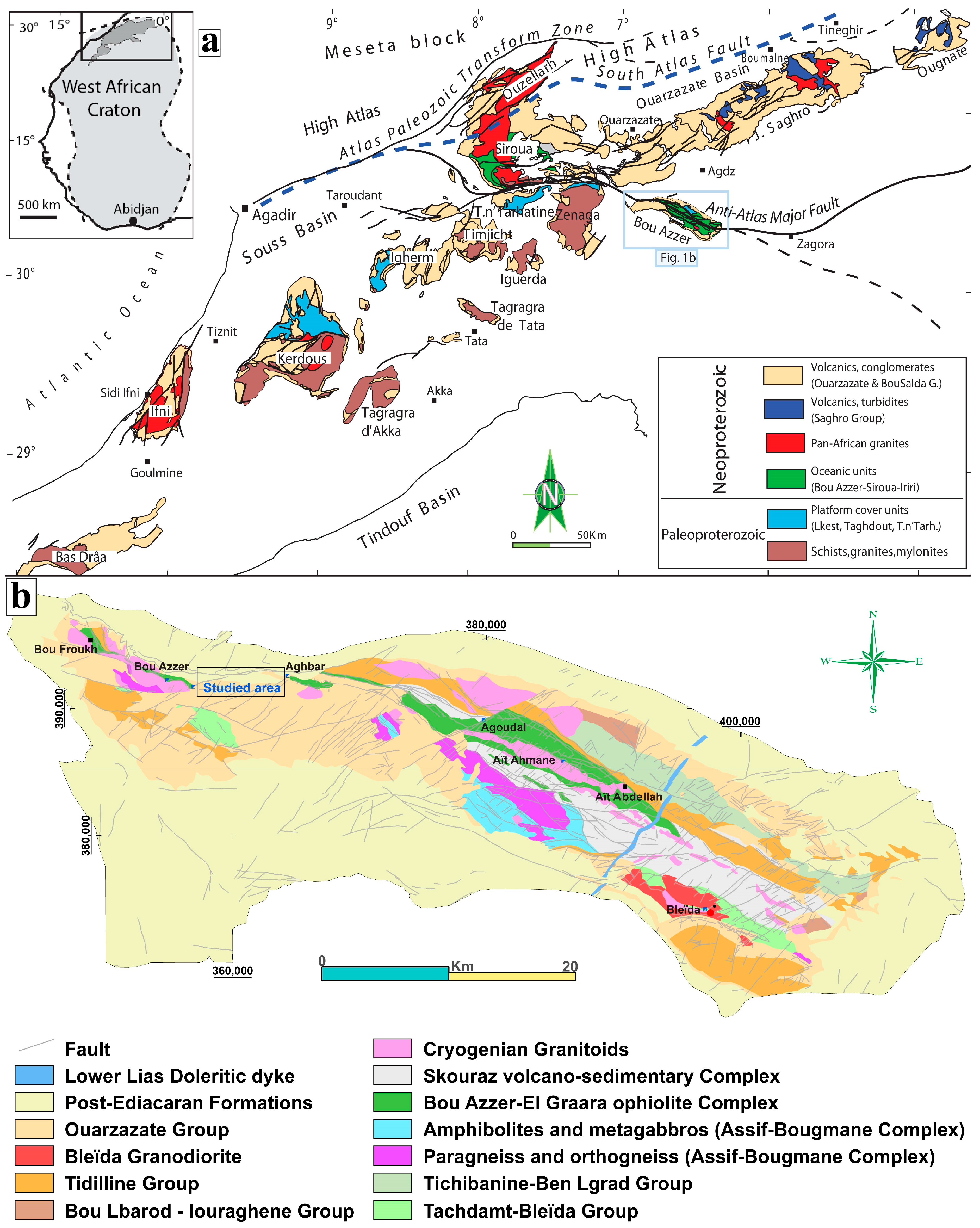
2. Geological Setting
3. Sampling and Analytical Methods
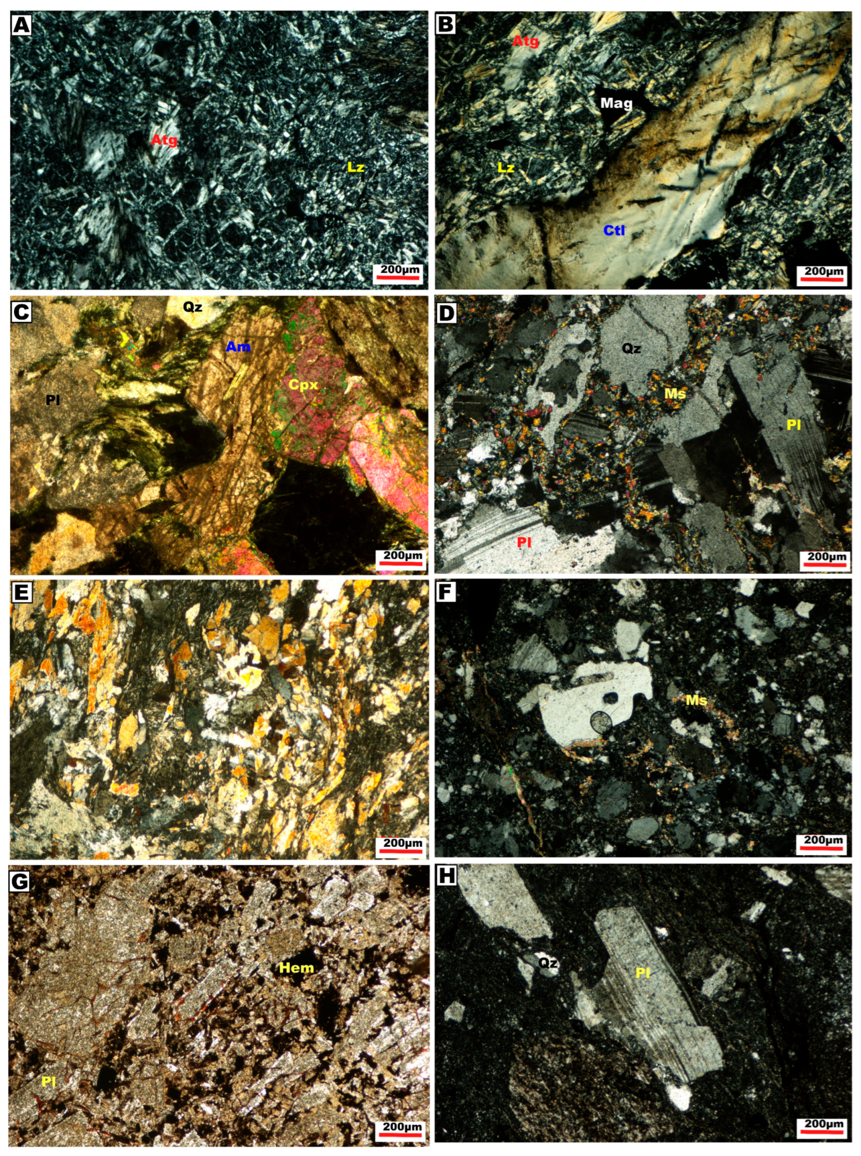
3.1. Petrographic Investigations
3.2. Ionic Leach Sampling
3.3. Structural Controls
4. Results
4.1. Structural Analysis
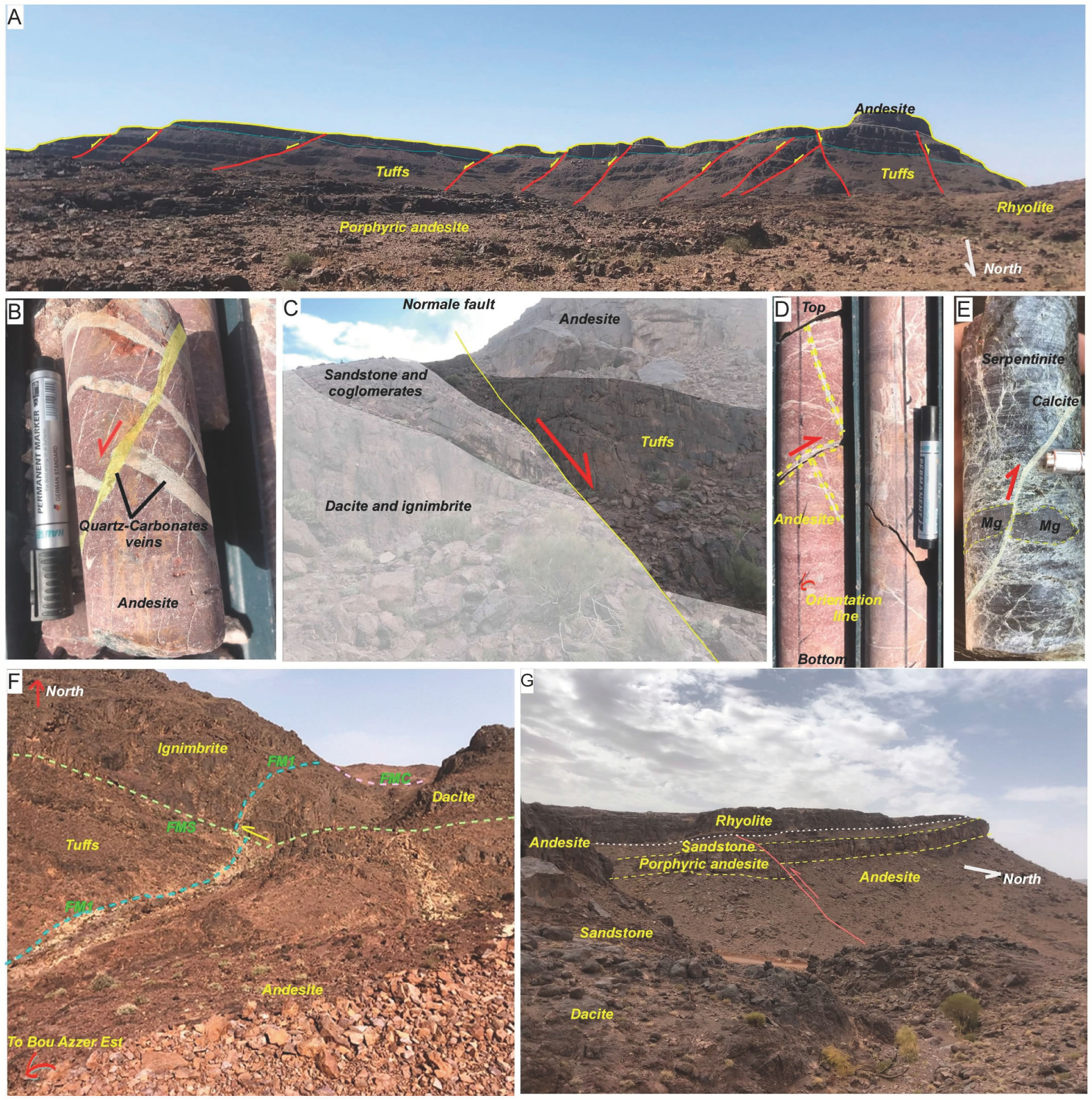
- ENE–WSW system: This fault system forms the boundary of the major lithological units (serpentinites, volcanic rocks) of the Ouarzazate group and quartz diorites. The faults of this system are generally strike-slip faults, often sinistral, and most of them are filled with quartz, carbonate, and iron oxide veins (Figure 5F) with a variable thickness ranging from a few centimeters to a few meters. This system of faults runs parallel to the major Anti-Atlas fault and was formed in earlier Pan-African phases [31,63]. In addition, these faults affect the volcano-detrital series of the Ouarzazate group and the Adoudounian series. This fault system comprises three major striking faults ranging from N 85° to N 95°: the Major North Fault (FMN), the Major Center Fault (FMC), and the Major South Fault (FMS), as shown in Figure 4 and Figure 5F.
- The NE–SW system is the most abundant Bou Azzer East area. It includes sinistral strike-slip faults oriented from N 40 to N 70 associated with the Pan-African tectonic, which caused NW–SE directed extension during the Ediacaran [63] and which is responsible for the division of the Cryogenian terrain into horsts and grabens (Figure 5A–C). A local and very limited compressive system has been mentioned in the district, generally represented by reverse faults at different scales (Figure 5D,E,G). The NE–SW system is similar to the various strike-slip faults with a sinistral component mapped in the underlying metamorphic basement. These faults control the sedimentation of the Ouarzazate Group series by functioning as normal faults with a strong sinistral strike-slip component [63].
- The NW–SE system is poorly represented in the study area. The fault and tension gashes dimensions are not more than several meters, and they are generally centimetric.
4.2. Ionic Leach Geochemistry
4.3. Geochemical Analysis Results
4.3.1. Mono-Elements
4.3.2. Bi-Element Analysis
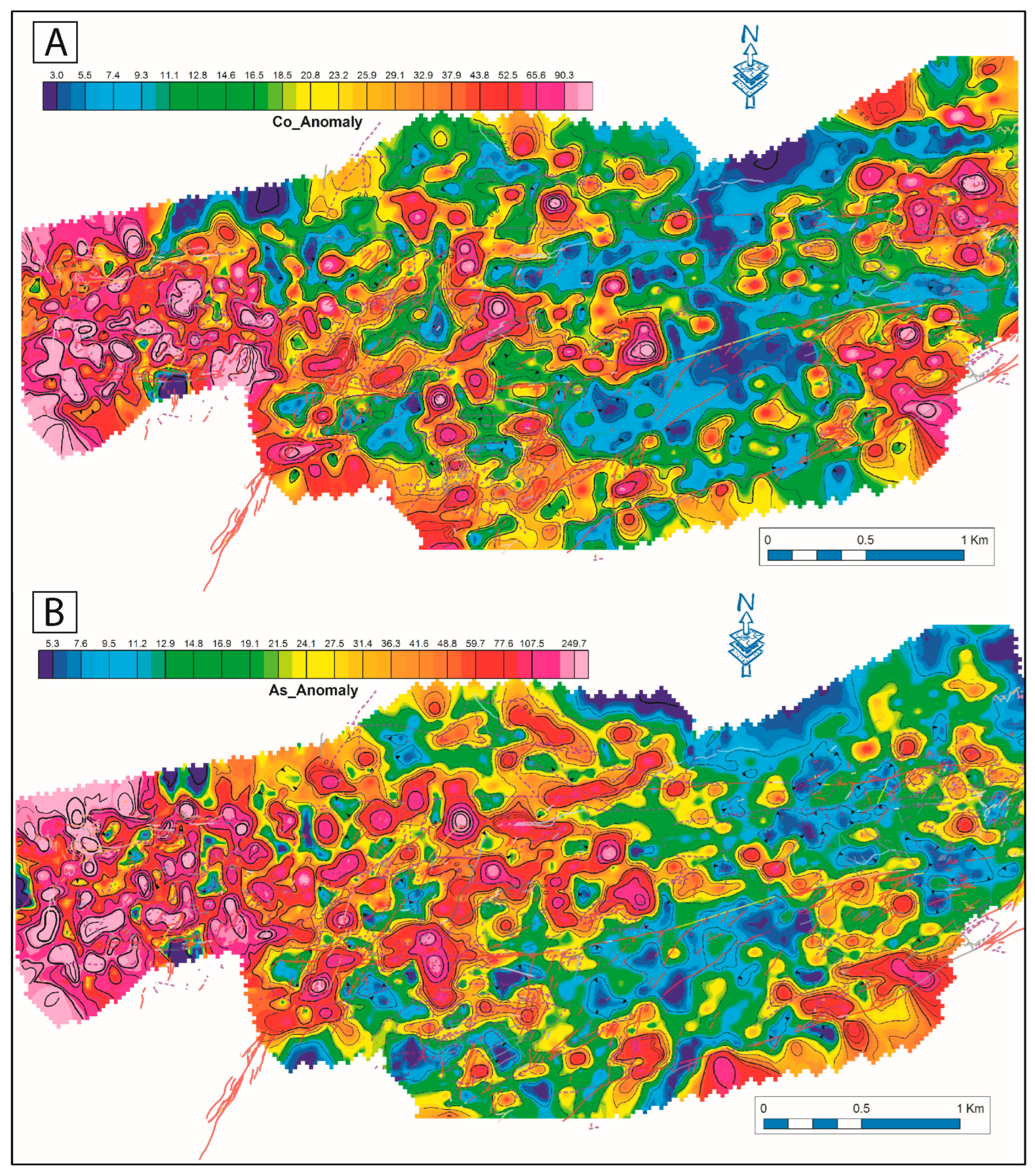
- Co–As
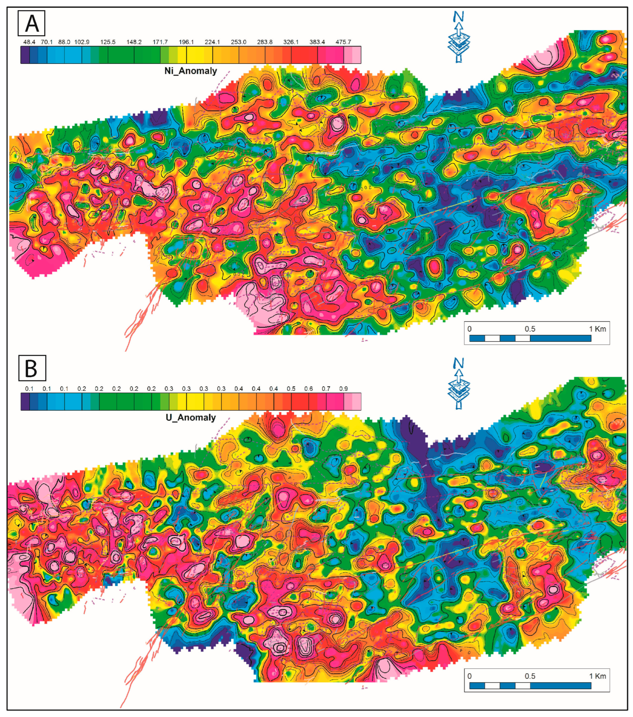
- Ni–Se
Base and Precious Metals (Cu-Ag)
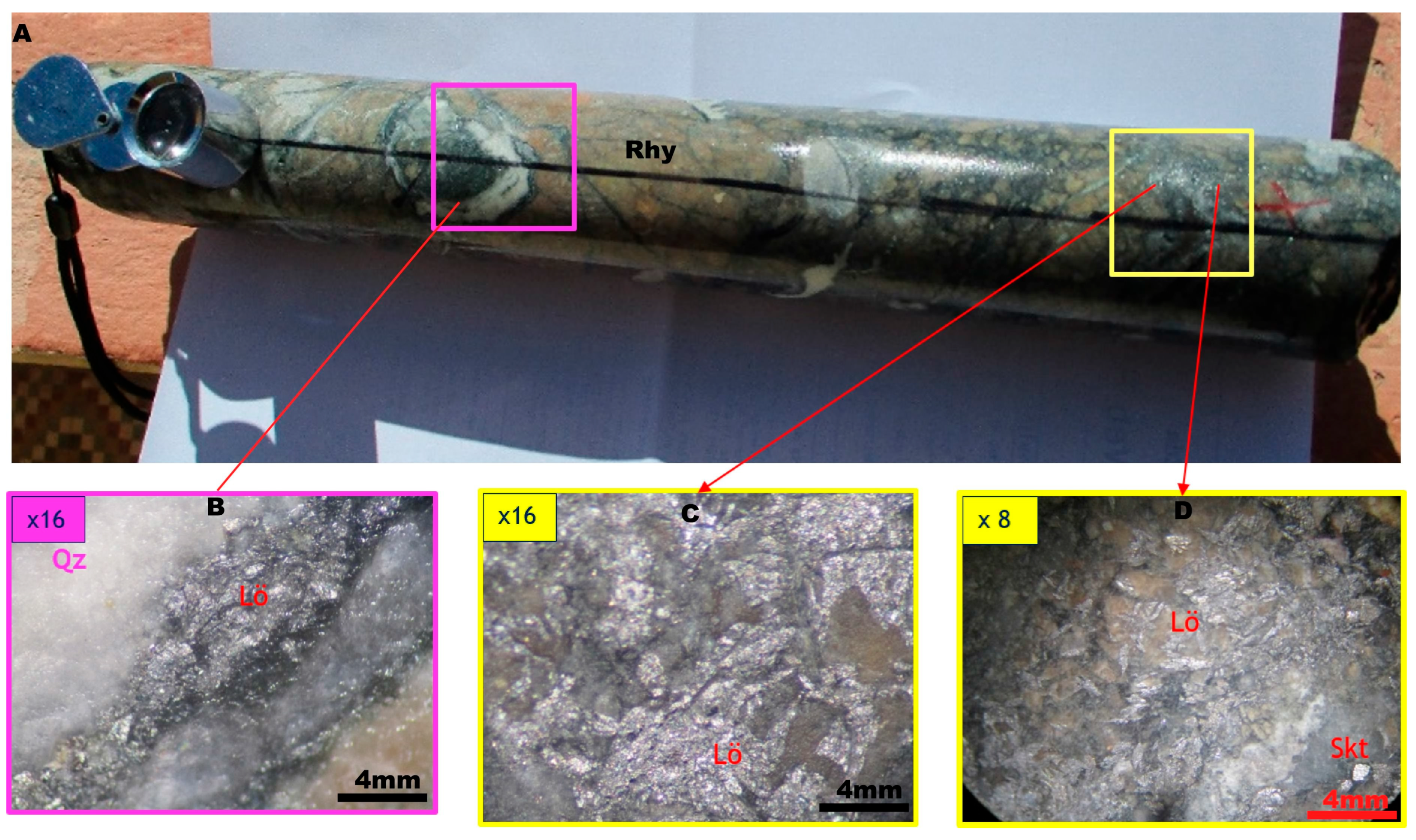
4.4. Drill Core Logging
4.4.1. Petrography
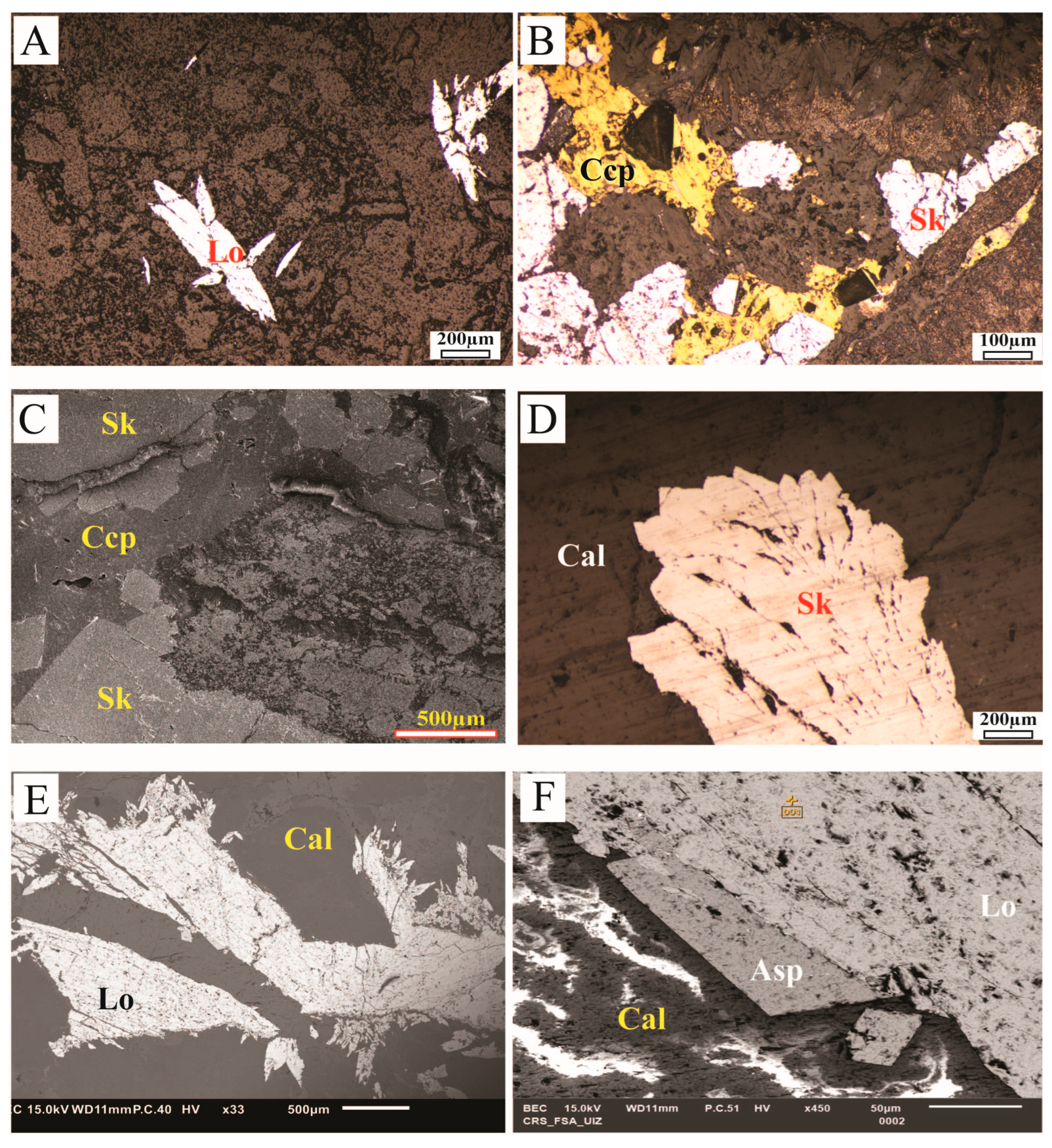
4.4.2. Ore Mineralogy
5. Discussion
5.1. Structural Features
5.2. Ionic Leach Geochemistry Versus Conventional Geochemistry
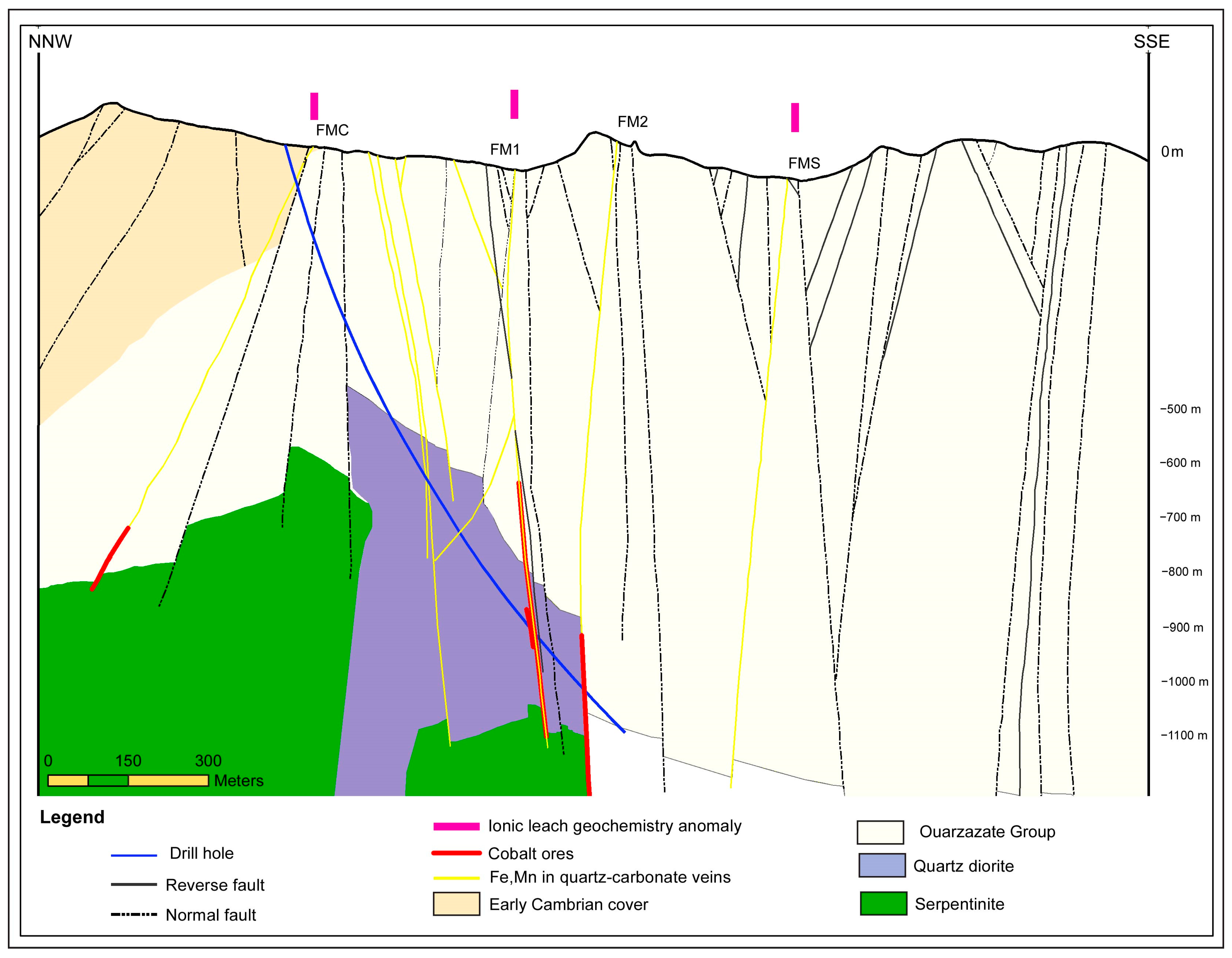
5.3. Drilling Validation
5.4. Mineral Paragenesis
6. Conclusions
- In the ABED area, a thick layer of volcanic rocks (rhyolite, dacite, ignimbrite, etc.) is interstratified with chaotic breccia and polygenic conglomerate outcrops. These volcano-sedimentary rocks belong to the Ouarzazate Group and they are overlain by the Adoudou Formation through an angular unconformity.
- The area is intersected by three family of faults and fractures: (i) the ENE–WSW family; (ii) the NE–SW family; and (iii) the NW–SE family, some of which are filled by quartz and quartz-carbonate gangues containing iron and/or manganese oxides. These fault systems are similar to those hosting mineralized in neighboring deposits.
- Multiple geochemical anomalies of Co, As, Ni, Ag, U, and Cu follow the main structural trends (NE–SW, NW–SE, and E–W). These anomalies are most prominent on the western side of the study area, with more subdued signatures in the central and eastern sectors.
- The integration of geochemical anomalies with structural data has enabled the identification of high-priority targets for the exploration of concealed ore bodies. Within the Bou Azzer inlier, several areas, particularly those analogous to the ABED zone located east of Aghbar toward Aït Ahmane, warrant the implementation of ionic leach geochemical surveys. Such efforts would be especially valuable in regions lacking surface exposures of serpentinized rocks.
- Due to its ability to detect mobile metal ions released by mineralization before fixation in the soil, the ionic leach geochemical method provides a precise tool for locating deeply buried mineralization.
- Diamond Drilling and structural mapping results confirm the continuity of the serpentinite massif beneath the Ediacarian volcano-sedimentary deposits. The core study also highlighted the presence of Co–Fe-bearing arsenides for the first time in this area.
Supplementary Materials
Author Contributions
Funding
Data Availability Statement
Acknowledgments
Conflicts of Interest
References
- Cobalt Institute. 2022. Available online: https://www.cobaltinstitute.org/wp-content/uploads/2023/01/Cobalt-Institute-Q4-2022-market-report_ENG-1.pdf (accessed on 2 September 2022).
- Cailteux, J.L.H.; Kampunzu, A.B.H.; Batumike, M.J. Lithostratigraphic position and petrographic characteristics of R.A.T. (“Roches Argilo-Talqueuses”) Subgroup, Neoproterozoic Katangan Belt (Congo). J. Afr. Earth Sci. 2005, 42, 82–94. [Google Scholar] [CrossRef]
- Hitzman, M.; Kirkham, R.; Broughton, D.; Thorson, J.; Selley, D. The Sediment-Hosted Stratiform Copper Ore System. In One Hundredth Anniversary Volume; Hedenquist, J.W., Thompson, J.F.H., Goldfarb, R.J., Richards, J.P., Eds.; Society of Economic Geologists: Littleton, CO, USA, 2005; pp. 606–642. [Google Scholar] [CrossRef]
- Bertrandsson Erlandsson, V.; Wallner, D.; Ellmies, R.; Raith, J.G.; Melcher, F. Trace element composition of base metal sulfides from the sediment-hosted Dolostone Ore Formation (DOF) CuCo deposit in northwestern Namibia: Implications for ore genesis. J. Geochem. Explor. 2022, 243, 107105. [Google Scholar] [CrossRef]
- Smith, C.G. Always the bridesmaid, never the bride: Cobalt geology and resources. Trans. Inst. Min. Metall. Sect. B Appl. Earth Sci. 2001, 110, B75–B80. [Google Scholar] [CrossRef]
- Crockett, R.N.; Clarkson, P.D. The exploitation of Antarctic minerals. Environ. Int. 1987, 13, 121–132. [Google Scholar] [CrossRef]
- Naldrett, A.J. World-class Ni-Cu-PGE deposits: Key factors in their genesis. Miner. Depos. 1999, 34, 227–240. [Google Scholar] [CrossRef]
- Malmqvist, L.; Kristiansson, K. Experimental evidence for an ascending microflow of geogas in the ground. Earth Planet. Sci. Lett. 1984, 70, 407–416. [Google Scholar] [CrossRef]
- Xie, S.; Li, H.; Li, H.; Deng, J.-F. Selective hydrogenation of stearonitrile over Ni–B/SiO2 amorphous catalysts in comparison with other Ni-based catalysts. Appl. Catal. A Gen. 1999, 189, 45–52. [Google Scholar] [CrossRef]
- Goldberg, I.S. Vertical migration of elements from mineral deposits. J. Geochem. Explor. 1998, 61, 191–202. [Google Scholar] [CrossRef]
- Smee, B.W. Laboratory and field evidence in support of the electrogeochemically enhanced migration of ions through glaciolacustrine sediment. J. Geochem. Explor. 1983, 19, 277–304. [Google Scholar] [CrossRef]
- Govett, G.J.S.; Dunlop, A.C.; Atherden, P.R. Electrogeochemical techniques in deeply weathered terrain in Australia. J. Geochem. Explor. 1984, 21, 311–331. [Google Scholar] [CrossRef]
- Hamilton, S.M. Electrochemical mass-transport in overburden: A new model to account for the formation of selective leach geochemical anomalies in glacial terrain. J. Geochem. Explor. 1998, 63, 155–172. [Google Scholar] [CrossRef]
- Mann, A.W.; Birrell, R.D.; Fedikow, M.A.F.; de Souza, H.A.F. Vertical ionic migration: Echanisms, soil anomalies, and sampling depth for mineral exploration. Geochem. Explor. Environ. Anal. 2005, 5, 201–210. [Google Scholar] [CrossRef]
- Cameron, E.M.; Hamilton, S.M.; Leybourne, M.I.; Hall, G.E.M.; Clenaghan, M.B. Finding deeply buried deposits using geochemistry. GEEA 2004, 4, 7–32. [Google Scholar] [CrossRef]
- Lovell, J.S.; Hale, M.; Webb, J.S. Soil air carbon dioxide and oxygen measurements as a guide to concealed mineral exploration in semi-arid and arid regions. Trans. Inst. Min. Metall. 1983, 92, 28–32. [Google Scholar]
- Malmqvist, L.; Kristiansson, K. A physical mechanism for the release of free gases in the lithosphere. Geoexploration 1985, 23, 447–453. [Google Scholar] [CrossRef]
- Hall, G.E.M.; Vaive, J.E.; Button, P. Detection of past underground nuclear events by geochemical signatures in soils. J. Geochem. Explor. 1997, 59, 145–162. [Google Scholar] [CrossRef]
- Wang, X.; Cheng, Z.; Lu, Y.; Xu, L.; Xie, X. Nanoscale metals in Earthgas and mobile forms of metals in overburden in wide-spaced regional exploration for giant deposits in overburden terrains. J. Geochem. Explor. 1997, 58, 63–72. [Google Scholar] [CrossRef]
- Amex Exploration, 2023 Mine d’or de la Propriete perron au. Available online: https://www.juniorminingnetwork.com/junior-miner-news/press-releases/414-tsx-venture/amx/142282-amex-generates-multiple-new-gold-and-vms-targets-at-perron-from-regional-exploration-program.html (accessed on 15 August 2024).
- Choubert, G. L’accident majeur de l’Anti-Atlas. Comptes Rendus De L’académie Des Sci. De Paris 1947, 224, 1172–1173. [Google Scholar]
- Admou, H. Structuration de la Paléosuture Ophiolitique Panafricaine de Bou Azzer-Siroua. Anti-Atlas Central, Maroc. Ph.D. Thesis, Cadi Ayyad University, Marrakech, Morocco, 2000; p. 201. [Google Scholar]
- Leblanc, M. Chapter 17 the Late Proterozoic Ophiolites of Bou Azzer (Morocco): Evidence for Pan- African Plate Tectonics. In Developments in Precambrian Geology; Elsevier: Amsterdam, The Netherlands, 1981; pp. 435–451. [Google Scholar] [CrossRef]
- Bodinier, J.L.; Dupuy, C.; Dostal, J. Geochemistry of Precambrian ophiolites from Bou Azzer, Morocco. Contr. Mineral. Pet. 1984, 87, 43–50. [Google Scholar] [CrossRef]
- Choubert, G. Histoire géologique du Précambrien de l’Anti-Atlas. Notes. Mém. Serv. Géol. Maroc 1963, 162, 352. [Google Scholar]
- Hefferan, K.P.; Admou, H.; Karson, J.A.; Saquaque, A. Anti-Atlas (Morocco) role in Neoproterozoic Western Gondwana reconstruction. Precambrian Res. 2000, 103, 89–96. [Google Scholar] [CrossRef]
- Gasquet, D.; Levresse, G.; Cheilletz, A.; Azizi-Samir, M.R.; Mouttaqi, A. Contribution to a geodynamic reconstruction of the Anti-Atlas (Morocco) during Pan-African times with the emphasis on inversion tectonics and metallogenic activity at the Precambrian–Cambrian transition. Precambrian Res. 2005, 140, 157–182. [Google Scholar] [CrossRef]
- Walsh, G.J.; Benziane, F.; Aleinikoff, J.N.; Harrison, R.W.; Yazidi, A.; Burton, W.C.; Quick, J.E.; Saadane, A. Neoproterozoic tectonic evolution of the Jebel Saghro and Bou Azzer—El Graara inliers, eastern and central Anti-Atlas, Morocco. Precambrian Res. 2012, 216–219, 23–62. [Google Scholar] [CrossRef]
- Hodel, F.; Triantafyllou, A.; Berger, J.; Macouin, M.; Baele, J.-M.; Mattielli, N.; Monnier, C.; Trindade, R.I.F.; Ducea, M.N.; Chatir, A.; et al. The Moroccan Anti-Atlas ophiolites: Timing and melting processes in an intra-oceanic arc-back-arc environment. Gondwana Res. 2020, 86, 182–202. [Google Scholar] [CrossRef]
- Ikenne, M.; Mustapha, S.; Cousens, B.; Montero, P.; Bea, F.; Askkour, F.; Haissen, F.; el Hassane, B.; Ernst, R.; Bajddi, A.; et al. Zircon U–Pb geochronology and Sm–Nd and Rb–Sr isotope systematics of Neoproterozoic granitoïds from Bou Azzer (Anti-Atlas—Morocco): The obduction trigger of the central Anti-Atlas terrane. J. Afr. Earth Sci. 2023, 202, 104900. [Google Scholar] [CrossRef]
- Leblanc, M. Ophiolites Précambriennes et Gîtes Arséniés de Cobalt (Bon Azzer. Maroc). Ph.D. Thesis, Université de Paris VI, Paris, France, 1975; 329p. [Google Scholar]
- Saquaque, A.; Admou, H.; Cisse, A.; Benyoucef, A.H.; Reuber, I. Les intrusions calco-alcalines dela boutonnière de Bou Azzer-El Graara (Anti-Atlas, Maroc): Marqueurs de la déformation majeure panafricaine dans un contexte de collision d’arc. Comptes Rendus De L’académie De Sci. Série IIa Sci. De La Terre et des Planètes 1989, 308, 1279–1283. [Google Scholar]
- Hefferan, K.; Soulaimani, A.; Samson, S.D.; Admou, H.; Inglis, J.; Saquaque, A.; Latifa, C.; Heywood, N. A reconsideration of Pan African orogenic cycle in the Anti-Atlas Mountains, Morocco. J. Afr. Earth Sci. 2014, 98, 34–46. [Google Scholar] [CrossRef]
- Triantafyllou, A.; Berger, J.; Baele, J.-M.; Diot, H.; Ennih, N.; Plissart, G.; Monnier, C.; Watlet, A.; Bruguier, O.; Spagna, P.; et al. The Tachakoucht–Iriri–Tourtit arc complex (Moroccan Anti-Atlas): Neoproterozoic records of polyphased subduction-accretion dynamics during the Pan-African orogeny. J. Geodyn. 2016, 96, 81–103. [Google Scholar] [CrossRef]
- Triantafyllou, A.; Berger, J.; Baele, J.M.; Bruguier, O.; Diot, H.; Ennih, N.; Monnier, C.; Plissart, G.; Vandycke, S.; Watlet, A. Intra–oceanic arc growth driven by magmatic and tectonic processes recorded in the Neoproterozoic Bougmane Arc complex (Anti–Atlas, Morocco). Precambrian Res. 2018, 304, 39–63. [Google Scholar] [CrossRef]
- Soulaimani, A.; Hefferan, K. Le Précambrien à La Bordure Nord Du Craton Ouest-Africain (Anti-Atlas et Haut Atlas, Maroc). Géologues 2017, 194, 33. [Google Scholar]
- Soulaimani, A.; Ouanaimi, H.; Saddiqi, O.; Baidder, L.; Michard, A. The Anti-Atlas Pan-African Belt (Morocco): Overview and pending questions. Comptes Rendus. Géosci. 2018, 350, 279–288. [Google Scholar] [CrossRef]
- Clauer, N. Utilisation de la methode rubidium-strontium pour la datation d’une schistosite de sediments peu metamorphises: Application au Precambrien II de la boutonniere de Bou Azzer-El Graara (Anti-Atlas, Maroc). Earth Planet. Sci. Lett. 1974, 22, 404–412. [Google Scholar] [CrossRef]
- Bouougri, E.H.; Lahna, A.A.; Tassinari, C.C.G.; Basei, M.A.S.; Youbi, N.; Admou, H.; Saquaque, A.; Boumehdi, M.A.; Maacha, L. Time constraints on Early Tonian Rifting and Cryogenian Arc terrane- continent convergence along the northern margin of the West African craton: Insights from SHRIMP and LA-ICP-MS zircon geochronology in the Pan-African Anti-Atlas belt (Morocco). Gondwana Res. 2020, 85, 169–188. [Google Scholar] [CrossRef]
- D’Lemos, R.S.; Inglis, J.D.; Samson, S.D. A newly discovered orogenic event in Morocco: Neoproterozic ages for supposed Eburnean basement of the Bou Azzer inlier, Anti-Atlas Mountains. Precambrian Res. 2006, 147, 65–78. [Google Scholar] [CrossRef]
- Blein, O.; Baudin, T.; Chèvremont, P.; Soulaimani, A.; Admou, H.; Gasquet, P.; Cocherie, A.; Egal, E.; Youbi, N.; Razin, P.; et al. Geochronological constraints on the polycyclic magmatism in the Bou Azzer-El Graara inlier (Central Anti-Atlas Morocco). J. Afr. Earth Sci. 2014, 99, 287–306. [Google Scholar] [CrossRef]
- Triantafyllou, A.; Berger, J.; Baele, J.-M.; Mattielli, N.; Ducea, M.N.; Sterckx, S.; Samson, S.; Hodel, F.; Ennih, N. Episodic magmatism during the growth of a Neoproterozoic oceanic arc (Anti-Atlas, Morocco). Precambrian Res. 2020, 339, 105610. [Google Scholar] [CrossRef]
- Naidoo, D.D.; Bloomer, S.H.; Saquaque, A.; Hefferan, K. Geochemistry and significance ofmetavolcanic rocks from the Bou Azzer ophiolite (Morocco). Precambrian Res. 1991, 53, 79–97. [Google Scholar] [CrossRef]
- Samson, S.D.; Inglis, J.D.; D’Lemos, R.S.; Admou, H.; Blichert-Toft, J.; Hefferan, K. Geochronological, geochemical, and Nd–Hf isotopic constraints on the origin of Neoproterozoic plagiogranites in the Tasriwine ophiolite, Anti-Atlas orogen, Morocco. Precambrian Res. 2004, 135, 133–147. [Google Scholar] [CrossRef]
- Inglis, J.D.; MacLean, J.S.; Samson, S.D.; D’Lemos, R.S.; Admou, H.; Hefferan, K. A precise U–Pb zircon age for the Bleïda granodiorite, Anti-Atlas, Morocco: Implications for the timing of deformation and terrane assembly in the eastern Anti-Atlas. J. Afr. Earth Sci. 2004, 39, 277–283. [Google Scholar] [CrossRef]
- Dolansky, L.M. Controls on the Genesis of Hydrothermal Cobalt Mineralisation: Insights from the Mineralogy and Geochemistry of the Bou Azzer Deposits, Morocco. Ph.D. Thesis, McGill University, Montreal, QC, Canada, 2007; 192p. Unpublished. [Google Scholar]
- Oberthür, T.; Melcher, F.; Henjes-Kunst, F.; Gerdes, A.; Stein, H.J.; Zimmerman, A.; El Ghorfi, M. Hercynian age of the cobalt-nickel arsenide (gold) ores, Bou Azzer, Anti-Atlas, Morocco: Re-Os, Sm-Nd, and U-Pb age determinations. Econ. Geol. 2009, 104, 1065–1079. [Google Scholar] [CrossRef]
- Subías, I.; Fanlo, I.; Hajjar, Z.; Gervilla, F.; Billström, K. Isotopic constraints on the age and source of ore-forming fluids of the Bou Azzer arsenide ores (Morocco). Ore Geol. Rev. 2022, 143, 104769. [Google Scholar] [CrossRef]
- Stein, H.J.; Zimmerman, A.; Ilmen, S.; Oberthür, T.; Maacha, L.; Zouhair, M. Molybdenite under Stress: Dating the Contrarian Bou Azzer Co-Ni-As Deposit, Morocco. Goldschmidt2021 Abstr. 2021. [CrossRef]
- Saintilan, N.J.; Ikenne, M.; Bernasconi, S.M.; Toma, J.; Creaser, R.A.; Souhassou, M.; Allaz, J.M.; Karfal, A.; Maacha, L.; Spangenberg, J.E. The World’s Highest-Grade Cobalt Mineralisation at Bou Azzer Associated with Gondwana Supercontinent Breakup, Serpentinite and Kellwasser Hydrocarbon Source Rocks. Am. J. Sci. 2023, 323, 12. [Google Scholar] [CrossRef]
- Tourneur, E.; Chauvet, A.; Kouzmanov, K.; Tuduri, J.; Paquez, C.; Sizaret, S.; Karfal, A.; Moundi, Y.; El Hassani, A. Co-Ni-arsenide mineralisation in the Bou Azzer district (Anti-Atlas, Morocco): Genetic model and tectonic implications. Ore Geol. Rev. 2021, 134, 104128. [Google Scholar] [CrossRef]
- Maacha, L.; Mustapha, E.G.; Ennaciri, A.; Sadiqqi, A.S.; Mohamed, B. Nouvelles Données Isotopiques et d’inclusions Fluides des Minéralisations Cobaltifères de Bou Azzer. Apport à la Géologie Economique de la Boutonnière. (Anti-Atlas central, Maroc). Notes et Memoires du Service Geologique- Maroc N° 579-2015 (H. IBOUH éd.). 2015, pp. 133–139. Available online: https://www.researchgate.net/publication/287210020 (accessed on 17 June 2025).
- Maacha, L. Etude Métallogénique et Géophysiques des Mineralisation s Cobaltifères et Cuprifères de Bou-Azzer El Graara Anti Atlas Maroc (Tome 1). Ph.D. Thesis, Cadi Ayyad University, Marrakech, Morocco, 2013; p. 344. [Google Scholar]
- Bouabdellah, M.; Maacha, L.; Levresse, G.; Saddiqi, O. The Bou Azzer Co–Ni–Fe–As (±Au ± Ag) District of Central Anti-Atlas (Morocco): A Long-Lived Late Hercynian to Triassic Magmatic- Hydrothermal to Low-Sulphidation Epithermal System. In Mineral Deposits of North Africa, Mineral Resource Reviews; Bouabdellah, M., Slack, J.F., Eds.; Springer International Publishing: Cham, Switzerland, 2016; pp. 229–247. [Google Scholar] [CrossRef]
- Ikenne, M.; Mustapha, S.; Saintilan, N.; Karfal, A.; Hassani, A.; Younes, M.; Mehdi, O.; Mohamed, E.-Z.; Zouhir, M.; Maacha, L. Cobalt-Nickel-Copper Arsenide, Sulpharsenide and Sulphide Mineralisation in the Bou Azzer Window, Anti-Atlas, Morocco: One Century of Multi-Disciplinary and Geological Investigations, Mineral Exploration and Mining; SP502-2019; Geological Society London Special Publications: London, UK, 2020. [Google Scholar] [CrossRef]
- Hajjar, Z.; Gervilla, F.; Fanlo, I.; Jiménez, J.-M.G.; Ilmen, S. Formation of serpentinite-hosted, Fe- rich arsenide ores at the latest stage of mineralisation of the Bou-Azzer mining district (Morocco). Ore Geol. Rev. 2021, 128, 103926. [Google Scholar] [CrossRef]
- Hajjar, Z.; Ares, G.; Fanlo, I.; Gervilla, F.; González-Jiménez, J. Cr-spinel tracks genesis of Co-Fe ores by serpentinite replacement at Bou Azzer, Morocco. J. Afr. Earth Sci. 2022, 188, 104471. [Google Scholar] [CrossRef]
- Gervilla, F.; Fanlo, I.; Colas, V.; Subias, I. Mineral compositions and phase relations of ni-co-fe arsenide ores from the aghbar mine, bou azzer, morocco. Can. Mineral. 2012, 50, 447–470. [Google Scholar] [CrossRef]
- Fanlo, I.; Gervilla, F.; Colás, V.; Subías, I. Zn-, Mn- and Co-rich chromian spinels from the Bou- Azzer mining district (Morocco): Constraints on their relationship with the mineralizing process. Ore Geol. Rev. 2015, 71, 82–98. [Google Scholar] [CrossRef]
- Soulaimani, A.; Ouanaimi, H.; Michard, A.; Montero, P.; Bea, F.; Corsini, M.; Molina, J.-F.; Rjimati, E.-C.; Saddiqi, O.; Hefferan, K. Quartzite Crests in Paleoproterozoic Granites (Anti-Atlas, Morocco); a Hint to Pan-African Deformation of the West African Craton Margin. J. Afr. Earth Sci. 2019, 157, 103501. [Google Scholar] [CrossRef]
- Soulaimani, A.; Razin, P.; Youbi, N.; Barbanson, L.; Admou, H.; Blein, O.; Gasquet, D.; Bouabdelli, M.; Anzar, C. Notice Explicative de la Carte Géologique du Maroc (1:50,000), Feuille Al Gloa; Notes et Mémoires du Service Géologique; Ministère De L’Energie, Des Mines, De L’Eau & De L’Environnement: Rabat, Morocco, 2013; 532p. [Google Scholar]
- Admou, H.; Razin, P.; Egal, E.; Youbi, N.; Soulaimani, A.; Blein, O.; Chèvremont, P.; Gasquet, D.; Barbanson, L.; Bouabdelli, M. Notice Explicative de la Carte Géologiques du Maroc (1/50,000), Feuille Aït Ahmane; Notes et Mémoires du Service Géologique; Ministère De L’Energie, Des Mines, De L’Eau & De L’Environnement: Rabat, Morocco, 2013; 533p. [Google Scholar]
- Azizi-Samir, M.R.; Ferrandini, J.; Tane, J.L. Tectonique et volcanisme tardi- Panafricains (580–560 M.A.) dans l’Anti-Atlas central (Maroc): Interprétation géodynamique à l’échelle du NW de l’Afrique. J. Afr. Earth Sci 1990, 10, 549–563. [Google Scholar] [CrossRef]
- Karaoui, B.; Breitkreuz, C.; Mahmoudi, A.; Youbi, N. Physical volcanology, geochemistry and basin evolution of the Ediacaran volcano-sedimentary succession in the Bas Draâ inlier (Ouarzazate Supergroup, Western Anti-Atlas, Morocco). J. Afr. Earth Sci. 2014, 99, 307–331. [Google Scholar] [CrossRef]
- Zahour, R.; Zahour, G.; Sy, A.H.; Baroudi, Z.; El Hadi, H.; Zerhouni, Y. Le volcanisme domeen du Néoprotérozoïque terminal de la boutonnière d’Aït Sawn (Anti-Atlas oriental, Maroc). Asgn 2014, 51–59. [Google Scholar] [CrossRef]
- Karaoui, B.; Breitkreuz, C.; Mahmoudi, A.; Youbi, N.; Hofmann, M.; Gärtner, A.; Linnemann, U. U–Pb zircon ages from volcanic and sedimentary rocks of the Ediacaran Bas Draâ inlier (Anti-Atlas Morocco): Chronostratigraphic and provenance implications. Precambrian Res. 2015, 263, 43–58. [Google Scholar] [CrossRef]
- Karaoui, A.; Breitkreuz, C.; Karaoui, B.; Yajioui, Z.; Mahmoudi, A.; Zanetti, A.; Langone, A. The Ediacaran volcano-sedimentary succession in the Western Skoura inlier (Central High Atlas, Morocco): Facies analysis, geochemistry, geochronology and geodynamic implications. Int. J. Earth Sci. 2021, 110, 889–909. [Google Scholar] [CrossRef]
- Zahour, R.; Zahour, G.; Hadi, H.E.; Zerhouni, Y.; Baroudi, Z.; Khoukhouchi, M. Petrology, geochemistry, and geodynamic implications of the Ediacaran volcanism of the southwestern edge of the Saghro massif (Eastern Anti-Atlas, Morocco). Turk. J. Earth Sci. 2022, 31, 339–358. [Google Scholar] [CrossRef]
- Bouladon, J.; Jouravsky, G. Les ignimbrites du Précambrien III de Tiouine et du sud marocain. Notes Mem. Serv. Geol. Du Maroc. 1954, 120, 37–59. [Google Scholar]
- Levresse, G. Contribution à L’établissement d’un Modèle Génétique des Gisements D’IMITER (Ag-Hg), Bou Madine (Pb-Zn-Cu-Ag-Au) et Bou Azzer (Co-Ni-As-Au-Ag) Dans l’Anti-Atlas Marocain. Master’s Thesis, CRPG-CNRS, Nancy, France, 2001; 277p. Unpublished. [Google Scholar]
- Technoexport: Russian group conducted a comprehensive research program that led to the discovery of the Taghouni, Bou Azzer East, and Tamdrost deposits. Rapport Technoexport. 1971; (Unpublished CTT report).
- Birrell, R. Cobalt Project Report, Globex Solutions. 2021; (unpublished report). [Google Scholar]
- Sagax Managem Group. Morocco, subsidiary, specialising in geophysics. (unpublished report).
- ALS Global Laboratory. Available online: https://www.alsglobal.com/en/geochemistry (accessed on 17 June 2025).
- Ennaciri, A.; Barbanson, L.; Touray, J.C. Mineralized hydrothermal solution cavities in the Co-As Ait Ahmane mine (Bou Azzer, Morocco). Mineral. Deposita 1995, 30, 75–77. [Google Scholar] [CrossRef]
- El Ghorfi, M. Etude Géochimique et Métallogénique des Métaux Précieux (or, Argent et Platinoïdes) Associes aux Mineralisation s a Co, Ni, Cr de Bou Azzer-El Graara, et dans la Série de Bleïda Far West, Anti-Atlas, Maroc. Ph.D. Thesis, Cadi Ayyad University, Marrakech, Morocco, 2006; p. 256. [Google Scholar]
- Arabi, Z.; Rinklebe, J.; El-Naggar, A.; Hou, D.; Sarmah, A.K.; Moreno-Jiménez, E. (Im) mobilization of arsenic, chromium, and nickel in soils via biochar: A meta-analysis. Environ. Pollut. 2021, 286, 117199. [Google Scholar] [CrossRef]
- Jouravsky, G. Aperçu géologique et métallogénique sur la région minéralisée de Bou Azzer. Notes Serv. Géol. Maroc. 1949, 74, 183–192. [Google Scholar]
- Jouravsky, G. Cobalt et Nickel, Géologie des Gîtes Minéraux Marocains; Notes et Mémoires du Service Géologique; Ministère De L’Energie, Des Mines, De L’Eau & De L’Environnement: Rabat, Morocco, 1952; 98p. [Google Scholar]
- Jouravsky, G. Composition chimique et nomenclature des bi-et triarséniures de cobalt, nickel et fer. Notes Serv. Géol. Maroc 1959, 18, 161–178. [Google Scholar]
- Goloubinow, R. Prospection géochimique du cobalt a Bou Azzer (Maroc). Sci. Terre Nancy 1956, 4, 211–226. [Google Scholar]
- Goloubinow, R. Rapport Technoexport. 1971; (Unpublished CTT report). [Google Scholar]
- Besson, M.; et Picot, P. Etude à la microsonde des minerais cobaltifères d’Arhbar, district de Bou Azzer (Maroc méridional). Notes Serv. Géol. Maroc. 1978, 39, 163–182. [Google Scholar]
- Maacha, L.; Azizi–Samir, R.; Bouchta, R. Gisements cobaltifères du district de Bou Azzer (Anti–Atlas): Structure, minéralogie et conditions de genèse. Chron. De La Rech. Minière 1998, 531–532, 65–75. [Google Scholar]
- El Hadi, H.F. Etude Pétrographique et Géochimique des Cumulats Ultramafiques et Mafiques du Complexe Ophiolitique de Bou Azzer El Graara (Anti-Atlas, Maroc). Ph.D. Thesis, Cadi Ayyad University, Marrakech, Morocco, 1988; p. 173. [Google Scholar]
- Hilal, R. L’ophiolite de Bou Azzer (Anti-Atlas, Maroc) Structure, Pétrographie, Géochimie et Contexte de Mise en Place. Ph.D. Thesis, Cadi Ayyad University, Marrakech, Morocco, 1991. [Google Scholar]
- Wafik, A.; Saquaque, A.; Boukhari, A.E. Les mineralisations sulfurées à Cu-Fe et les alterations associees dans les ophiolites proterozoiques de bou azzer et de khzama (anti-atlas, maroc). Ophiliti 2001, 2001, 47–62. [Google Scholar]
- Leblanc, M. Un complexe ophiolitique dans le Précambrien II de l’Anti-Atlas central (Maroc): Description, interprétation et position stratigraphique. Maroc. Notes Mém. Serv. Géol. Maroc 1972, 236, 119–144. [Google Scholar]
- Leblanc, M. Les formations infracambriennes de Bou-Azzer (Anti-Atlas, Maroc): Lithostratigraphie, tectonique et position structurale. Notes et Mém. Serv. Géol. Maroc 1973, 254, 7–14. [Google Scholar]
- Hinaje, S. Apport de L’analyse de la Tectonique Cassante Tardi et Post-Panafricaine à la Modélisation de la Mise en Place des Mineralisation s dans la Boutonnière de Bou-Azzer (Anti-Atlas, Maroc). Ph.D. Thesis, Université Mohammed V, Faculté des Sciences de Rabat, Agdal, Rabat, 1995. [Google Scholar]
- Rahimi, A.; Beraaouz, E.; Nachit, H.; Saquaque, A. Analyse pétrostructurale des mylonites de la zone de cisaillement de Bougmane (Bou Azzer-El Graara, Anti-Atlas, Maroc). Bull. Inst. Sci Rabat 1996, 20, 43–49. [Google Scholar]
- Salmi, S.; Errami, E.; Jouhari, A.; El Kabouri, J.; Ennih, N.; Outaaoui, O.; Ilmen, S.; Moundi, Y.; Karfal, A.; Maacha, L. Constraints of the regional deformation on the hydrothermal veins in Ousdrat and Aït Ahmane ore deposits (Bou Azzer-El Graara inlier, central Anti-Atlas, Morocco): Implications for mineral exploration. J. Afr. Earth Sci. 2024, 220, 105441. [Google Scholar] [CrossRef]
- Bradshaw, P.M.D.; Thomson, I.; Smee, B.W.; Larsson, J.O. The application of different analytical extractions and soil profile sampling in exploration geochemistry. J. Geochem. Explor 1974, 3, 209–225. [Google Scholar] [CrossRef]
- Amedjoe, G. Application of the Mobile Metal Ion Geochemical Technique in the Location of Buried Gold Mineralization in Essase Concession, Eastern Region, Ghana. J. Geol. Min. Res. 2013, 5, 147–160. [Google Scholar] [CrossRef]
- Mann, A.W. Strong versus weak digestions: Ligand-based soil extraction geochemistry. Geochem. Explor. Environ. Anal. 2010, 10, 17–26. [Google Scholar] [CrossRef]
- Jaffal, M.; Abderrahmane, S.; Ilmen, S.; Anzar, F.; KCHIKACH, A.; Manar, A.; Soulaimani, A.; Maacha, L.; Bajddi, A. Insights into the deep structure of the Bou Azzer-El Graara inlier (Central Anti-Atlas, Morocco): Inference from high-resolution magnetic data, and geodynamic implications. Tectonophysics 2023, 856, 229865. [Google Scholar] [CrossRef]
- Leblanc, M.; Billaud, P. Cobalt arsenide orebodies related to an upper Proterozoic ophiolite; Bou Azzer (Morocco). Econ. Geol. 1982, 77, 162–175. [Google Scholar] [CrossRef]
- Ez-Zghoudy, M.; Ikenne, M.; Souhassou, M.; Belfoul, M.A.; Gouiza, M.; Ilmen, S.; Ousbih, M.; Karfal, A.; Maacha, L.; Zouhair, M. Structural controls on the Co and Ni-bearing arsenides from the Bou Azzer mine (Case of Aït Ahmane F53 vein deposit): Implications for mineral exploration. J. Afr. Earth Sci. 2023, 202, 104929. [Google Scholar] [CrossRef]
- Ahmed, A.; Arai, S.; Abdel-Aziz, Y.; Ikenne, M.; Rahimi, A. Platinum-group elements distribution and spinel composition in podiform chromitites and associated rocks from the upper mantle section of the Neoproterozoic Bou Azzer ophiolite, Anti-Atlas, Morocco. J. Afr. Earth Sci. 2009, 55, 92–104. [Google Scholar] [CrossRef]
- Souiri, M.; Aissa, M.; Ahmed, A.H.; El Azmi, M.; Mezougane, H.; Moussaid, A.; El Basbas, A. Hydrothermal alterations of the Bou Azzer East Co-Ni-As-Au deposits (central Anti-Atlas, Morocco). Geosci. J. 2021, 25, 635–660. [Google Scholar] [CrossRef]


| ppb | Co | As | Ni | Ag | Au | Cu | Mo | Ce | Cd | Pb | Se | Th | U |
|---|---|---|---|---|---|---|---|---|---|---|---|---|---|
| Median | 19.40 | 22.60 | 192.00 | 15.15 | 1.00 | 1460.00 | 78.75 | 0.70 | 4.40 | 1.80 | 10.00 | 0.06 | 0.29 |
| Average | 33.46 | 55.29 | 232.01 | 16.35 | 1.28 | 1535.98 | 117.15 | 0.88 | 4.77 | 2.16 | 11.87 | 0.08 | 0.39 |
| Minimum | 0.70 | 1.80 | 13.00 | 1.30 | 0.12 | 95.00 | 6.40 | 0.05 | 0.40 | 0.05 | 2.00 | 0.01 | 0.03 |
| First quartile | 9.00 | 11.10 | 102.00 | 11.90 | 0.65 | 1090.00 | 49.90 | 0.40 | 3.00 | 1.00 | 8.00 | 0.03 | 0.17 |
| Third quartile | 39.90 | 55.30 | 320.00 | 19.00 | 1.56 | 1880.00 | 139.00 | 1.10 | 6.20 | 2.90 | 14.00 | 0.10 | 0.48 |
| Maximum | 933.00 | 1240.00 | 1340.00 | 191.00 | 20.70 | 12,450.00 | 1220.00 | 6.80 | 23.80 | 30.50 | 93.00 | 0.93 | 5.42 |
| Standard deviation | 45.83 | 95.64 | 169.82 | 9.08 | 1.08 | 720.21 | 110.38 | 0.67 | 2.51 | 1.86 | 6.89 | 0.08 | 0.40 |
| Variance | 2098.83 | 9141.37 | 28821.81 | 82.32 | 1.17 | 518,402.29 | 12,176.30 | 0.45 | 6.28 | 3.45 | 47.38 | 0.01 | 0.16 |
| Detection limit | 0.30 | 0.30 | 1.00 | 0.05 | 0.01 | 1.00 | 0.20 | 0.05 | 0.05 | 0.10 | 0.04 | 0.01 | 0.03 |
| Correlation | Co | As | Ni | Ag | Au | Mo | Cr | Cu | Th | Ce | Pb | Se | U |
| Co | 1 | ||||||||||||
| As | 0.59 | 1 | |||||||||||
| Ni | 0.49 | 0.16 | 1 | ||||||||||
| Ag | 0.39 | 0.28 | 0.23 | 1 | |||||||||
| Au | 0.28 | 0.3 | 0.1 | 0.46 | 1 | ||||||||
| Mo | 0.44 | 0.38 | 0.34 | 0.18 | 0.2 | 1 | |||||||
| Cr | −0.13 | −0.089 | −0.29 | 0.031 | 0.12 | 0.04 | 1 | ||||||
| Cu | 0.34 | 0.2 | 0.44 | 0.48 | 0.27 | 0.3 | −0.072 | 1 | |||||
| Th | 0.22 | 0.087 | 0.44 | 0.021 | −0.11 | 0.0015 | −0.24 | 0.13 | 1 | ||||
| Ce | 0.35 | 0.17 | 0.43 | 0.065 | −0.11 | 0.011 | −0.27 | 0.11 | 0.63 | 1 | |||
| Pb | 0.43 | 0.31 | 0.24 | 0.21 | −0.037 | 0.045 | −0.16 | 0.22 | 0.31 | 0.43 | 1 | ||
| Se | 0.33 | 0.12 | 0.54 | 0.22 | 0.12 | 0.48 | 0.04 | 0.29 | 0.17 | 0.17 | 0.074 | 1 | |
| U | 0.64 | 0.54 | 0.33 | 0.049 | 0.14 | 0.22 | 0.37 | 0.34 | 0.18 | 0.61 | 0.69 | 0.13 | 1 |
| S (wt.%) | As (wt.%) | Fe (wt.%) | Co (wt.%) | Ni (wt.%) | Total | |
| Lo | 1.07 | 76.37 | 22.55 | 100 | ||
| Asp | 17.11 | 52.92 | 29.97 | 100 | ||
| Lo | 76.67 | 16.68 | 6.65 | 100 |
Disclaimer/Publisher’s Note: The statements, opinions and data contained in all publications are solely those of the individual author(s) and contributor(s) and not of MDPI and/or the editor(s). MDPI and/or the editor(s) disclaim responsibility for any injury to people or property resulting from any ideas, methods, instructions or products referred to in the content. |
© 2025 by the authors. Licensee MDPI, Basel, Switzerland. This article is an open access article distributed under the terms and conditions of the Creative Commons Attribution (CC BY) license (https://creativecommons.org/licenses/by/4.0/).
Share and Cite
Lmahfoudi, Y.; Ouali, H.; Ilmen, S.; Hajjar, Z.; El-Masoudy, A.; Birrell, R.; Sapor, L.; Zouhair, M.; Maacha, L. Prediction of Buried Cobalt-Bearing Arsenides Using Ionic Leach Geochemistry in the Bou Azzer-El Graara Inlier (Central Anti-Atlas, Morocco): Implications for Mineral Exploration. Minerals 2025, 15, 676. https://doi.org/10.3390/min15070676
Lmahfoudi Y, Ouali H, Ilmen S, Hajjar Z, El-Masoudy A, Birrell R, Sapor L, Zouhair M, Maacha L. Prediction of Buried Cobalt-Bearing Arsenides Using Ionic Leach Geochemistry in the Bou Azzer-El Graara Inlier (Central Anti-Atlas, Morocco): Implications for Mineral Exploration. Minerals. 2025; 15(7):676. https://doi.org/10.3390/min15070676
Chicago/Turabian StyleLmahfoudi, Yassine, Houssa Ouali, Said Ilmen, Zaineb Hajjar, Ali El-Masoudy, Russell Birrell, Laurent Sapor, Mohamed Zouhair, and Lhou Maacha. 2025. "Prediction of Buried Cobalt-Bearing Arsenides Using Ionic Leach Geochemistry in the Bou Azzer-El Graara Inlier (Central Anti-Atlas, Morocco): Implications for Mineral Exploration" Minerals 15, no. 7: 676. https://doi.org/10.3390/min15070676
APA StyleLmahfoudi, Y., Ouali, H., Ilmen, S., Hajjar, Z., El-Masoudy, A., Birrell, R., Sapor, L., Zouhair, M., & Maacha, L. (2025). Prediction of Buried Cobalt-Bearing Arsenides Using Ionic Leach Geochemistry in the Bou Azzer-El Graara Inlier (Central Anti-Atlas, Morocco): Implications for Mineral Exploration. Minerals, 15(7), 676. https://doi.org/10.3390/min15070676