Abstract
A multiproxy methodology has been employed to characterise two granite anchors discovered on the seabed near the island of Nueva Tabarca (Alicante, Southeast Spain). According to the significant archaeological context where they were found, the studied anchors can be dated from the Roman ages (late Republican period). One of the most interesting aspects is the absence of regional geological outcrops with rocks compatible with the granite used in the production of the anchor, which shows a foreign origin consistent with the connection of the anchor to maritime transport across the Mediterranean Sea. The lack of precise information about the artifact’s origin underscores the interest and need for the application of petrological techniques to determine its provenance. The methodology utilised encompasses five distinct techniques: (1) non-destructive textural analysis using X-ray microcomputed tomography; (2) K–Ar dating; (3) petrological characterisation through optical microscopy; (4) geochemical characterisation using X-ray fluorescence and atomic absorption spectrometry. The results allow for a comparison of the anchor rock’s characteristics with various granite outcrops along the Mediterranean coasts (Eastern, Central, and Western sectors), suggesting potential source areas based on petrological compatibility with the material under study. The findings point to the origin of the Nueva Tabarca granite anchor being granite outcrops in Southern Italy (Calabria), reinforcing the connection between the Spanish southeastern coasts and Southern Italy. These results highlight the utility and significance of multiproxy petrological methodologies in the geoarchaeological study of decontextualised artifacts.
1. Introduction
This study of stone anchors holds significant value in marine archaeology, as it contributes to the reconstruction of ancient maritime trade routes and enhances our understanding of the evolution of civilisations, trade networks, and cultural exchanges between different regions [1]. The recovery of such anchors supports the assumption that ships once sailed or anchored in the area, providing tangible evidence of maritime activity. In addition to stone anchors, other elements associated with shipwrecks are essential for the archaeological study of ancient trade routes and maritime connections, such as cargo remains, and in particular stone cargoes [2,3]. Moreover, recent studies have explored the symbolic value attributed to these objects across different cultures [4].
Numerous stone anchors of various shapes, types and chornologies have been reported during both onshore and offshore explorations worldwide, notably in the Arabian Gulf, Egypt, Israel, Greece, India, China, Korea, Japan, Sri Lanka, the Black Sea, the Mediterranean Sea, the South China Sea, and the Red Sea [1,5,6,7]. One of the fundamental issues concerning these stone anchors is their chronology. While it is widely accepted that this type of anchor was commonly used during the Early Iron Age [8], their use continues—albeit with varying frequency—into later periods. This has been confirmed, for example, in shipwrecks from different periods, such as the La Madonnina wreck, dated between 325 and 300 BC; the Agde D wreck, dated to the 1st century BC [9]; the Tantura B wreck, dated to the early 9th century AD [10]; and the Marsala wreck, dated between the 8th and 12th centuries AD [11]. In the ancient port of Olbia, an anchor was radiocarbon-dated to the 3rd century AD [12], and two examples were found on the beach of Kibbutz Ein Gedi, dated between the 10th and 12th centuries AD [13,14,15,16]. Stone anchors were still in use as late as the 20th century in the context of small-scale traditional fishing practices [17,18,19]. The type of stone used and its size are widely diverse, ranging from well over a ton to just a few kilograms, corresponding to their employment on board crafts of different sizes, for different purposes, and travelling on different routes [4]. But, more importantly, a key aspect of this research is the determination of the provenance of the stone material used in the anchors, which may reveal a geographic origin distinct from the ports between which the vessel navigated.
Identifying the original quarry of any onshore, out-of-context archaeological stone materials is a complex task. It requires precise petrographic characterisation—often limited by sampling constraints—as well as a comprehensive understanding of the regional geology surrounding the site. However, determining the source area of the rock used in stone anchors found offshore is considerably more challenging. These objects are intrinsically linked to long-distance mobility and navigation routes, which significantly broadens the geographical scope of potential outcrops compatible with the anchor’s lithology. In the bibliography, there are very few studies focused on the provenance of stone anchors [1], being especially scarce in the western Mediterranean.
In this study, we focus on two stone anchors recovered from the seabed near the island of Nueva Tabarca (SE of Spain) (Figure 1). Similar types of anchors with comparable weights have been found at locations near the study area along the Spanish Mediterranean coast (Denia, Xàbia, and Benidorm) (Figure 1), at depths ranging from 10 to 15 m. However, these findings have not yet been the subject of an in-depth study and currently lack a clear context that would allow for definitive chronological interpretation.
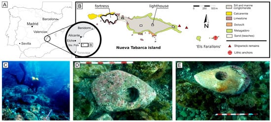
Figure 1.
(A) Geographical location of the island of Nueva Tabarca off the southeastern coast of Spain. (B) Simplified geological map of the island showing the position of the studied anchors. (C) Stone anchors on the seabed during the in situ documentation process. (D,E) Stone anchors TAB2023-001 and TAB2023-002, respectively, photographed in situ.
The objective of this study is, therefore, the multiproxy characterisation of the rock used in the fabrication of the stone anchors from Nueva Tabarca, with the aim of addressing the provenance analysis of the rock. This analysis is conducted by comparing it with bibliographic data from Mediterranean outcrops and quarries. The results of this study contribute to reconstructing the historical context of Nueva Tabarca and its significance as a strategic enclave within the Mediterranean trade routes. Moreover, this study provides a valuable methodology for approaching the provenance of stone anchors. The study of the provenance of the rock used in stone anchors is a topic scarcely addressed in the literature, often due to the complexity of the cases involved, making this methodology a significant advancement in the study of these archaeological artifacts.
2. Geographical and Archaeological Context
The island of Nueva Tabarca (Alicante, SE of Spain) is located 22 km from the city of Alicante and 8 km from the city of Santa Pola. It constitutes a small archipelago made up of a main island and numerous surrounding islets and reefs (Figure 1). Due to its position relative to the coast and its distance from important cities and historical settlements, the island has held unique significance over time. The earliest documented references to the island date back to the Roman period [20]. Throughout history, it has been recognised for its significance as a fishing enclave and as a refuge for various activities. As a consequence of its use as a haven for Barbary pirates since the 16th century and as a base for raids along the Spanish coast, a fortified settlement was constructed in 1770 to provide stronger resistance against these incursions.
The area of Els Farallons, located at the eastern tip of the archipelago, is known for the recurring presence of amphora fragments between depths of 0 and −5 m, and the possible existence of several Roman shipwrecks in this area has been proposed. Azuar et al. [21], based on the scarce documented ceramic remains discovered here, suggested a chronology from the mid-1st century BC for these remains. The two studied stone anchors were located in the Els Farallons region [21,22] (Figure 1).
In June 2021, a survey of the study area was conducted to assess the archaeological context of the anchors and to carry out sampling. The underwater survey mainly uncovered amphora fragments that share similar chronological and typological characteristics to one another [23]. Most of the recovered material consists of amphorae from Italy, particularly from the Adriatic coast, Apulia, and Campania, which were used for transporting wine during the late Republican period, between the 2nd century BC and the 1st century BC. In addition, a small number of common and cooking wares influenced by South Iberian and North African regions were identified. A detailed analysis of the ceramic pastes allowed for the identification of different groups, primarily from Italy and the Betica (South Spain), with a marginal presence of materials from North Africa and the Guadalquivir area (Southwest Spain) [23].
Most of the amphorae found belong to the Lamboglia 2 type, which was used for transporting wine from the Italian coast. These are accompanied by Dressel 1 amphorae, also associated with wine distribution but originating from the Tyrrhenian region of Italy, particularly Campania. Together, these pieces represent 92% of the recovered ceramic material, suggesting a predominantly Italian origin and a clear late Republican chronology. Additionally, a fragment of a Beltran IIa amphora was documented, which, due to its high Imperial chronology, does not align with the rest of the fragments.
The analysis of the ceramic pastes shows that 81.93% of the recovered material comes from Apulia and the Adriatic, with a small proportion of pastes from Campania and the Betica coast. Fragments from North Africa and the Guadalquivir area are scarce and marginal [21]. Overall, the ceramic assemblage is homogeneous in terms of chronology and origin, with a clear predominance of Italian materials, fitting into the period between the last third of the 2nd century BC and the mid-1st century BC.
Based on the evidence and material record obtained during the survey, several hypotheses have been proposed to explain the presence of the two stone anchors. The most plausible hypothesis is their association with a shipwreck, supported by the close proximity of these two nearly identical anchors (separated by only 16 to 18 m), and the contextual evidence of Roman-era amphorae and common pottery fragments, potentially from a cargo of Italian wine. Despite the uncertainties introduced by a single fragment of a later amphora type, the archaeological context suggests a late Republican date for the anchors [23]. A systematic excavation of the marine deposits would provide further evidence to confirm or reject this hypothesis, offering new insights into the historical context of Nueva Tabarca and its potential role in Mediterranean trade.
3. Materials and Methods
The two anchors studied have been referenced as TAB2023-001 and TAB2023-002. In June 2021, a complete study of these anchors was conducted following the methodology of Briggs and Campbell [24]. They were marked with a surface decompression buoy and positioned using GPS (AsteRx-U3 RTK GNSS, Septentrio NV, Leuven, Belgium). Subsequently, in situ measurements were taken, and a 360-degree photogrammetric coverage was conducted. After the photogrammetry, two microcores were obtained, which were later used for the petrographic characterisation of the rock. Finally, the anchors were returned to their original locations.
The studied anchors (Figure 2) consist of two blocks with similar dimensions (1.05 × 0.64 × 0.17 m for TAB2023-001 and 1.11 × 0.31 × 0.25 m for TAB2023-002), with estimated weights of 228.8 kg and 313.7 kg, respectively. Both anchors have a through-hole with diameters of 0.19 m and 0.29 m, respectively, slightly off-centre in the frontal view of the anchors. Microcores obtained for analysis have a diameter of 1.5 cm and lengths of 10.2 cm (TAB2023-001) and 9.5 cm (TAB2023-002) (Figure 3). Multiple techniques were used to comprehensively analysis and characterise the materials. Initially, non-destructive techniques were employed (X-ray computed microtomography), followed by subsampling for the application of destructive techniques (petrographic optical microscope, X-ray diffraction, X-ray fluorescence, and atomic absorption spectrometry). Finally, two representative samples were dated using the K–Ar method.
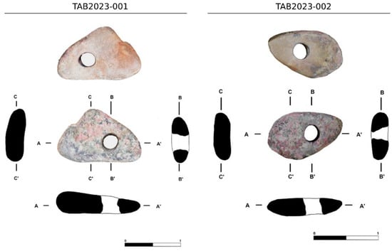
Figure 2.
3D reconstruction and transverse sections of the studied stone anchors generated through photogrammetric processing.
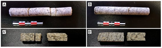
Figure 3.
Photographs of the microcores extracted from anchors TAB2023-001 (A) and TAB2023-002 (B). The lower images (A′,B′) show the diametral cross-sections of the corresponding microcores.
The X-ray computed microtomography (μCT-RX) system used in this study was a BIR Actis 130/150 equipped with a polychromatic X-ray generator (Bio-Imaging Research Inc., Lincolnshire, IL, USA). Energy of 100 keV/80 mA was used to scan both microcores. Three-dimensional images were reconstructed using both Actis and Avizo-Fire software (v.n. 2019.2, Thermo Fisher Scientific, Waltham, MA, USA). The software was also employed to perform a preliminary assessment of the mineralogical content of the samples by means of digital analysis of the acquired 3D models. The dimensions of the voxel, corresponding to the resolution of the images, were 10 × 10 × 10 μm.
Petrographic characterisation was performed on thin sections prepared from selected microcore fragments, using an Olympus CX31 (Olympus GMBH, Hamburg, Germany) polarising microscope equipped with an Olympus DP27 (Olympus GMBH, Hamburg, Germany) digital camera.
Powdered samples obtained from selected microcore fragments were used for geochemical analyses. Major and trace element concentrations were determined via wavelength-dispersive X-ray fluorescence spectrometry (XRF) using a PANalytical ZETIUM spectrometer (4 kV, rhodium tube) (Malvern Panalytical, Almelo, The Netherlands). Additional trace element analyses were conducted using inductively coupled plasma mass spectrometry (ICP-MS) with an Agilent 7500ce (Agilent Technologies Inc., Tokyo, Japan).
Semiquantitative K–Ar ages were obtained using two whole-rocks samples, each weighing ca. 30 mg each; the samples were melted in a resistance furnace under high vacuum, totally extracting the Ar contained in them. The amounts of total Ar were calculated based on the total current Ar and the calibrated sensitivity of the Noblesse mass spectrometer at Dipartimento di Scienze dell’Ambiente e della Terra, Università di Milano Bicocca, Italy. Radiogenic Ar concentrations were obtained by subtracting the atmospheric Ar content, given by the non-radiogenic 36Ar concentrations. Finally, the K content was not directly determined, as the available fragments were too small and too heterogeneous to enable this to be done. Samples were assumed to contain the average K content of terrestrial granites (3.3%) for an approximate result. The results were interpreted based on these considerations.
4. Results
4.1. Petrographic Characterisation
Petrographic analysis of the two microcores (TAB2023-001 and TAB2023-002), conducted under a petrographic optical microscope, reveals that both lithic anchors are made from a similar rock type: a two-mica granite characterised by a holocrystalline, inequigranular texture (Figure 4). The granite is primarily composed of quartz and potassium feldspar (microcline), with a consistently low presence of plagioclase—though isolated large plagioclase crystals are occasionally observed. Quartz appears in polycrystalline, anhedral aggregates that are generally equigranular and often exhibit undulatory extinction. The crystals are unfractured and have clean sections. Potassium feldspars show typical grid twinning and exhibit significant grain size variation (from 0.5 to 3 mm), often displaying sericitic alteration, which may affect either the entire crystal section or just its core. Mica content, around 8% in both samples, consists of muscovite and biotite, with muscovite being slightly more abundant. The micas are short, tabular crystals arranged in preferred orientations—two main alignments intersecting at approximately 30°—and show no signs of deformation or metamict alteration. Porosity is very low and entirely intercrystalline in both samples.
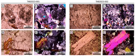
Figure 4.
Photomicrographs obtained under a petrographic polarizing microscope from thin sections of microcores TAB2023-001 (A,B) and TAB2023-002 (C,D). Images (A–D) were taken under plane-polarized light, while (A′–D′) show the same fields of view under crossed polarizers.
Despite these shared features, subtle differences distinguish the two samples. Sample TAB2023-001 displays a slightly coarser texture, with crystal sizes ranging from 0.5 to 3 mm. Quartz constitutes approximately 40% of the sample, while potassium feldspar content reaches approximately 50%. In contrast, sample TAB2023-002 shows a finer texture, with an average crystal size of approximately 1 mm and maximum sizes reaching up to 2 mm—particularly among the quartz crystals. Potassium feldspar content in this sample is slightly lower, at approximately 40%, and the crystals show fewer signs of sericitic alteration compared to TAB2023-001. The quartz aggregates in TAB2023-002 tend to form larger masses with sharply defined, often concavo–convex or slightly sutured, intercrystalline boundaries. In both samples, plagioclase is rare (approximately 1%), usually appearing as small crystals with minimal sericitisation and characteristic polysynthetic twinning.
The 3D model obtained through X-ray microtomography reveals a homogeneous distribution of minerals throughout the microcores, with a slightly preferred crystal orientation (Figure 5). Mineral contents of the samples were estimated through digital processing of the microCT-XR images, yield quartz contents of 36% (TAB2023-001) and 48% (TAB2023-002). Estimated porosity is very low, with values of 0.24% in sample TAB2023-001 and 0.02% in sample TAB2023-002.
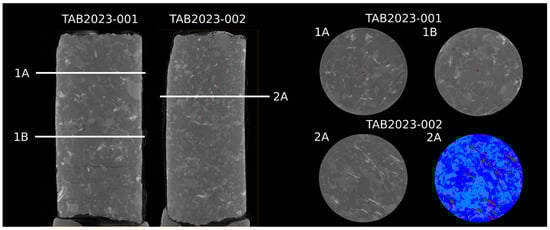
Figure 5.
X-ray microcomputed tomography (μCT) reconstructions of the studied microcores, showing longitudinal sections (left) and transverse sections (right). An interpreted section is also included, based on digital image analysis for mineral identification: quartz is shown in light blue, feldspars and plagioclase in dark blue, and micas and opaque oxides in red. Diameter of microcores: 1.5 cm.
4.2. Mineralogical and Geochemical Characterisation
Table 1 presents the chemical composition of the samples, determined using X-ray fluorescence (for major element composition) and inductively coupled plasma mass spectrometry (for trace element composition). The depiction of this chemical composition using the Q–P diagrams of Debon and Lefort [25] indicates that the rocks are petrographically classified as granites, transitioning toward adamellites (TAB2023-002) (Figure 6). The geochemical composition obtained from both major and trace elements is similar in both samples.

Table 1.
Chemical composition of the studied stone anchor samples, including major elements (wt%) and trace elements (ppm).
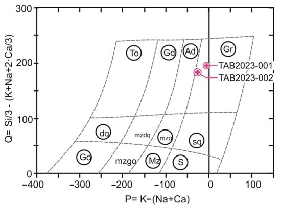
Figure 6.
Classification of the anchor rock samples using the Q–P diagrams of Debon and Lefort [23]. Q and P are expressed in molar proportions multiplied by 1000. The diagram includes the areas where common igneous rocks are defined as follows: Gr = granite, Ad = adamellite, Gd = granodiorite, To = tonalite, sq = quartz syenite, mzq = quartz monzonite, mzdq = quartz monzodiorite, dq = quartz diorite, s = syenite, Mz = monzonite, mzgo = monzogabbro, and Go = gabbro.
4.3. Rock Age Assessment (K–Ar Method)
Semiquantitative K–Ar age estimates were obtained for microcores TAB2023-001 and TAB2023-002. Based on the ratio of radiogenic 40Ar to K, the resulting ages are 296 and 228 million years, respectively (Table 2). These approximate ages are consistent with granites associated with plutonic complexes from the Late Paleozoic period. The age difference between the two samples could be attributed to three, not mutually exclusive, factors: (1) the rocks used for the two lithic anchors came from distinct geological sources; (2) the assumed potassium content for TAB2023-002 may have been overestimated—had it been at the lower end of the typical K concentration range for terrestrial granites (e.g., K = 2.5%), the calculated age would align with that of TAB2023-001; and (3) the granite in TAB2023-002 may have undergone a higher degree of alteration compared to that in TAB2023-001.
Table 2.
Semiquantitative K–Ar ages of the studied samples.
5. Analysis of the Provenance of the Lithic Anchors
To narrow down the potential source areas of the granite blocks used in the two anchors, the following three boundaries are established:
- (1)
- (2)
- Given the inherent mobility of the artifacts (stone anchors), the potential provenance area must encompass the entire Mediterranean coastline.
- (3)
- Considering the relatively low degree of craftsmanship and the functional nature of these anchors, reducing production costs prevailed over the importation of high-quality materials from distant inland sources. To minimize production and transport expenses, the stone was likely sourced near the consumption area. In this context, coastal granite outcrops represent the most plausible sources.
By applying these criteria, the origin of the granite blocks can be confidently restricted to a limited number of granite outcrops along the Mediterranean coast.
Figure 7 illustrates the distribution of granite outcrops across the Mediterranean basin, with a focus on seven major coastal areas located along the eastern (Aegean Sea; areas 4a, 4b, and 5), central (Tyrrhenian Sea; areas 3a, 3b, 3c, 6a, and 6b), and western (areas 1a, 1b, and 7) Mediterranean. All of these outcrops are historically significant, having supplied granite blocks for architectural and construction purposes during antiquity. For instance, Mysian, Naxian, and Troadic granites were widely used throughout the Roman Empire [26,27], while the Elba, Giglio, Sardinian, and Calabrian quarries were extensively exploited during the Roman and Medieval periods [28,29].
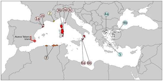
Figure 7.
Location of the main granitic outcrops along the Mediterranean coast. [1a] Eastern Pyrenees; [1b] Cap de Creus (Eastern Pyrenees); [2] Saint-Tropez Peninsula; [3a] Sardinia; [3b] Corsica; [3c] Elba and Giglio Islands; [4a] Sandanski; [4b] Eastern Aegean coast, Türkiye; [5] Naxos Island; Calabrian outcrops: [6a] Nicotera and [6b] Parghelia; [7] Algeria (Beni-Snouss).
Table 3 summarises the principal petrological features of the granites that could be potential sources for the anchors. Although each area may exhibit internal petrological variation, the table provides a baseline for comparison based on published data from quarrying zones and regional studies. Notably, the lack of detailed geological work for area 7 (Algeria) limits any robust assessment of its compatibility.
Table 3.
Principal petrological features of granites from the areas considered in Figure 7. Main minerals include the following: quartz (Q), feldspar (Fds), orthoclase (Ort), microcline (Mc), plagioclase (Pl), biotite (Bt), muscovite (Ms), and hornblende (Hrn).
Geochronologically, Mediterranean granites can be broadly categorised into two distinct groups: those formed during the Hercynian orogeny (320–280 Ma) and those related to Alpine magmatism (younger than 65 Ma). The semiquantitative K–Ar ages obtained for the anchor samples (296 Ma and 228 Ma) are broadly consistent with Hercynian granitoids. Although these ages are not highly precise due to sampling limitations and assumptions regarding potassium content, they effectively rule out a Miocene origin. The required K2O content to produce such ages from a Miocene rock would have to be unrealistically high (>50%). This constraint narrows the focus to Paleozoic granites and eliminates the eastern Mediterranean and the islands of Elba and Giglio as plausible sources.
A more refined approach to provenance determination can be achieved by comparing the mineralogical and geochemical data from the anchors with published datasets from known Mediterranean granite sources (Table 3). The use of geochemical indicators (usually based on trace elements) is a well-established approach in archaeometry for provenance investigations. This is commonly employed for sourcing volcanic rocks and pyroclastic materials [39,40,41,42,43]. Based on the Debon and Lefort diagrams (P–Q and A–B) (Figure 8) [25], it is possible to determine that the geochemical profiles of the anchors best match those of areas 1, 2, and 6b (Figure 7), all of which correspond to peraluminous granite–adamellite compositions. Rocks from areas 1b, 3a, 3b, 3c, 6a, and 7 are considered unlikely sources of the anchor granite, as they display markedly lower geochemical affinity, often falling within granodioritic fields and exhibiting significantly lower Al2O3 content (fields III–IV of the A–B diagram).
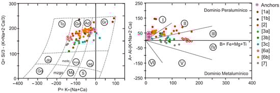
Figure 8.
Chemical-mineralogical Q–P and A–B diagrams of Debon and Lefort, plotting the studied anchors and samples from the Mediterranean outcrops considered possible source areas (Figure 7; Table 3). The Q, P, A, and B parameters are expressed in molar proportions multiplied by 1000. The Q–P diagram includes the areas where common igneous rocks are defined as follows: Gr = granite, Ad = adamellite, Gd = granodiorite, To = tonalite, sq = quartz syenite, mzq = quartz monzonite, mzdq = quartz monzodiorite, dq = quartz diorite, s = syenite, Mz = monzonite, mzgo = monzogabbro, and Go = gabbro. The A–B diagram includes the following fields: (I) peraluminous; (II) intermediate peraluminous; (III) strongly peraluminous or peralkaline; (IV) weakly metaluminous; (V) metaluminous–intermediate mafic content; (VI) strongly metaluminous–mafic.
The Harker diagrams (Figure 9) further support this interpretation, with the anchor samples plotting predominantly within the point clouds of samples from areas 2 and 6b. However, samples from area 2 show extreme dispersion in SiO2 content and related elemental concentrations, which weakens their statistical and geochemical alignment with the anchors. Conversely, samples from area 6b exhibit tighter clustering, suggesting a more coherent petrogenetic history and a stronger geochemical match with the anchors.
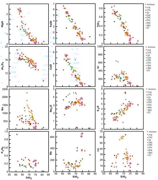
Figure 9.
Harker diagrams for selected major (wt%) and trace (ppm) elements for the studied granitoid rocks.
Literature-based mineralogical descriptions (Table 3) of the granite from area 6b (Calabria, Italy) indicate a two-mica granitoid (muscovite and biotite) with subtle magmatic foliation and preferred crystal orientation [29,44]. This is strikingly consistent with the anchor samples, which also exhibit both micas and aligned mica fabrics, reinforcing the petrographic match. By contrast, granites from area 2 (southern France), though geochemically comparable in some diagrams, lack muscovite [33], thereby limiting their compatibility.
Additionally, historical quarrying activity in area 6b—particularly at the Parghelia quarries—has been well-documented since the Roman period [26,29], whereas no such evidence exists for area 2. This contextual factor adds significant weight to the hypothesis that the anchors originated from southern Italy. According to the results published in Cirrincione et al. [29], extractive activity during the Roman period in the Nicotera–Parghelia quarries is documented up to the first century AD. According to this work, granite extraction ceased in 369 AD, following the earthquake that destroyed the city of Nicotera. However, quarries in this area were reopened in later periods, maintaining intermittent activity until recent times. Specifically, the Parghelia quarry is an important archaeological site due to its excellent state of preservation, which allows for direct observation of Roman quarrying methodologies. At the same time, the site provides new insights into the stone materials used in antiquity and the Roman granite trade within the Mediterranean region.
Finally, the strong correlation between the petrographic provenance of the anchors and the ceramic assemblage from the Nueva Tabarca site further supports this interpretation. Most of the amphora fragments recovered at the site originate from southern Italy (Campania, Apulia, and Adriatic coast), and are datable to the late Republican period. These artifacts suggest the presence of an Italian vessel and cargo in transit, potentially associated with the wine trade. Thus, the granite anchors likely formed part of the equipment of a ship produced and outfitted in southern Italy.
In summary, the convergence of petrological, geochemical, geochronological, and archaeological data supports the identification of Calabrian granite (area 6b) as the most probable source of the Nueva Tabarca stone anchors. This finding provides tangible evidence of long-distance exchange networks operating across the central and western Mediterranean during the late Roman Republic and reinforces the importance of petrological analyses in unraveling the life histories of mobile archaeological artifacts. It should be noted that this study represents a preliminary provenance proposal based on archaeometric data from the anchors and a bibliographic review of compatible outcrops across the Mediterranean. Therefore, future research should focus on exhaustive sampling of these outcrops and obtaining comparable data using consistent methodologies, in order to validate the results presented here.
6. Conclusions
This study aims to determine the provenance of two granitic stone anchors recovered from a submerged archaeological context off the coast of a Spanish island in the Mediterranean. To do so, this study uses a comprehensive multiproxy methodology of five analytical techniques: (1) non-destructive textural analysis via X-ray microcomputed tomography; (2) K–Ar dating; (3) optical petrography; (4) mineralogical and geochemical characterisation using X-ray fluorescence; and (5) inductively coupled plasma mass spectrometry. The combination of these five, minimally invasive, sampling techniques is effective in assessing both the physical and chemical natures of the rock materials.
Optical petrographic analysis reveals that both studied anchors (TAB2023-001 and TAB2023-002) are composed of inequigranular, two-mica granites, with low plagioclase content, moderate sericitisation of K-feldspar, and a preferential orientation of short tabular micas (biotite and muscovite). MicroCT imaging confirms mineral homogeneity and very low porosity (<0.25%) in both samples. Geochemically, the anchors exhibit high SiO2 (74.5–75 wt%), elevated K2O (4.7–5.1 wt%), and low CaO and FeOt contents. In the Q–P and A–B classification diagrams of Debon and Lefort [25], the samples are consistent with rocks in the range of peraluminous granites to adamellites.
Semiquantitative K–Ar dating yields ages of approximately 296 and 228 Ma, compatible with the Late Paleozoic Hercynian orogeny, effectively excluding Miocene or Alpine intrusions as potential sources of the rock materials. These data narrow the provenance search to coastal outcrops of Hercynian-age granites along the Mediterranean basin.
Comparative petrographic, geochemical, and chronological analyses, referenced against bibliographic data from selected Mediterranean granitic outcrops, reveal a strong match with granitoids from southern Italy, specifically, the Parghelia quarries in Calabria. The rocks from these quarries are also two-mica peraluminous granites with weak magmatic foliation and similar mineralogical features. By contrast, other potential source areas, such as those in southern France or Northeastern Spain, either lack muscovite or exhibit greater geochemical dispersion. Furthermore, the documented presence of Roman quarrying activity in the Parghelia area and the absence of known quarries in the other geochemically compatible zones strengthen the likelihood of Calabria being the origin of the granite blocks used to make the anchors.
Archaeologically, the underwater context near Nueva Tabarca, where the anchors were located, yields a high concentration of amphorae fragments associated with wine transport from southern Italy (Apulia, Campania, and the Adriatic coast) during the late Roman Republican period (2nd–1st century BC). The close spatial association between the anchors and this assemblage reinforces their contemporaneity and supports the interpretation of a shipwreck event involving central Mediterranean trade networks.
This study makes two important contributions to the literature. First, it demonstrates how the integration of geological, archaeological, and historical data allows for the reconstruction of ancient mobility patterns and, in so doing, highlights the interconnectedness of the western Mediterranean in antiquity. Secondly, the results highlight the utility and significance of multiproxy petrological methodologies in the geoarchaeological study of decontextualised artifacts.
Author Contributions
J.M.-M., Conceptualization, processing and analyzing the samples, interpreting the results, and writing the original draft. H.C. and N.F., sample analysis and draft review. J.M.V., J.A.M.-M., A.J.L., F.L.Q. and J.M.P.B., archaeological context, sample collecting, interpreting results, and draft review. All authors have read and agreed to the published version of the manuscript.
Funding
This work was supported by the Spanish Ministry of Science and Innovation (MCIN) [grant numbers PID2020-116896RB-C21 and PID2020-116896RB-C22 funded by MCIN/AEI/10.13039/501100011033].
Data Availability Statement
Data are contained within this article.
Acknowledgments
The authors greatly appreciate the contribution of Igor M. Vila and Valentina Barberini from the Università degli Studi di Milano-Bicocca, in dating and studying the granitoid samples. The initiatives have been carried out in collaboration with the Secretaría General de Pesca (SGP-MAPA) and the Nueva Tabarca Island Marine Reserve.
Conflicts of Interest
The authors declare no conflicts of interest.
References
- Tripati, S.; Mudholkar, A.; Vora, K.H.; Ramalingeswara Rao, B.; Gaur, A.S. Geochemical and mineralogical analysis of stone anchors from west coast of India: Provenance study using thin sections, XRF and SEM-EDS. J. Archaeol. Sci. 2010, 37, 1999–2009. [Google Scholar] [CrossRef]
- Beltrame, C.; Lazzarini, L.; Antonelli, F. A Roman shipwreck with a cargo of Apuan marble (marmor lunense) at Punta del Francese (Stintino-Sassari, Sardinia). Archaeometry 2020, 62, 1081–1094. [Google Scholar] [CrossRef]
- Fournier, F.; Leonide, P.; Marie, L.; Quillevere, F.; Margerel, J.P.; Miholjek, I.; Dugonijic, P.; Carre, M.B.; Cavassa, L.; Morsilli, M.; et al. Provenance of the ballast stones from the Roman Republican ship Ilovik-Paržine 1: A hypothesis about its place of construction. J. Archaeol. Sci. Rep. 2024, 57, 104580. [Google Scholar] [CrossRef]
- Yamasaki, M. Bronze Age stone anchors as material metaphor: Applying conceptual blending theory to investigate their symbolic value. J. Archaeol. Method Theory 2024, 31, 1272–1291. [Google Scholar] [CrossRef]
- Raban, A. Three-hole composite stone anchors from a medieval context at Caesarea Maritima, Israel. Int. J. Naut. Archaeol. 2000, 29, 260–272. [Google Scholar] [CrossRef]
- Hristov, I. Antique Stone Anchors, Stone and Lead Anchors Stocks from the Collection of the National Museoum of History; End of 2nd ML B.C.—3rd century A.D. Varna (Bulgaria); UNICART: Varna, Bulgaria, 2013. [Google Scholar]
- Warburton, D.A. Mediterranean stone anchors: Bronze Age tarde and social practice. J. Anc. Stud. 2020, 7, 193–211. [Google Scholar] [CrossRef]
- Toth, J.A. Composite stone anchors in the ancient Mediterranean. Typology, chronology and their rtole in the reconstruction of ancient trace. A proposal. Acta Arch. Acad. Sci. Hung. 2002, 53, 85–117. [Google Scholar]
- Parker, A.J. Ancient Shipwrecks of the Mediterranean and the Roman Provinces; Oxford University Press: Oxford, UK, 1992. [Google Scholar]
- Wachsmann, S.; Kahanov, Y.; Hall, J. The Tantura B Shipwreck: The 1996 INA/CMS Joint Expedition to Tantura Lagoon. INA Quartely 1997, 24, 3–15. [Google Scholar]
- Purpura, G. Un relitto di età normanna a Marsala. Archeol. Subacquea 1985, 29, 128–136. [Google Scholar]
- Fernández, D. Anclas líticas de tres agujeros en Galicia. In Actas del I Congreso de Arqueología Náutica y Subacuática Española; Nieto, F.X., Bthencourt, M., Eds.; Servicio de Publicaciones de la Universidad de Cádiz: Cartagena, Spain, 2013. [Google Scholar] [CrossRef]
- Nissenbaum, A.; Carmi, I.; Hadas, G. Dating of ancient anchors from the Dead Sea. Naturwissenschaften 1990, 77, 228–229. [Google Scholar] [CrossRef]
- Hadas, G.; Liphschitz, N.; Bonani, G. Two ancient anchors from Ein Gedi, on the Dead Sea, Israel. Rev. Int. De Arqueol. Náutica 2005, 34, 299–307. [Google Scholar] [CrossRef]
- Oron, A.; Hadas, G.; Liphschitz, N.; Bonani, G. A New type of composite anchor dated to the Fatimi-Crusader period from the Dead Sea, Israel. Int. J. Naut. Archaeol. 2008, 37, 295–301. [Google Scholar] [CrossRef]
- Hadas, G.; Segal, I.; Yofee, O.; Stein, M. Study of Roman anchor from the Dead Sea shore. Arqueometría 2009, 51, 1008–1014. [Google Scholar] [CrossRef]
- Frost, H. Ports, Cairns and Anchors. A Pharaonic Outlet on the Red Sea. Topoi 1996, 6, 869–902. [Google Scholar] [CrossRef]
- Benito Dominguez, A. Aproximación a la historia de las anclas lítica a partir de las recuperadas en al costa gipuzkoana. Itsas Memoria. Rev. De Estud. Marítimos Del País Vasco 2000, 3, 665–684. (In Spanish) [Google Scholar]
- Matés, J.M. El ancla lítica de tres orificios de la playa de Karraspio (Mendexa, Bizkaia). Kobie Ser. Paleoantropol. 2015, 34, 283–300. (In Spanish) [Google Scholar]
- Pérez Burgos, J.M. Nueva Tabarca. Patrimonio Integral en el Horizonte Marítimo. Ph.D. Thesis, Alicante University, Madrid, Spain, 2017. Available online: https://rua.ua.es/dspace/handle/10045/73330 (accessed on 11 February 2025). (In Spanish).
- Azuar, R.; Lajara, J.; Inglese, O. Informe Preliminar de la Prospección Arqueológica Subacuática en el Área Exterior de la Reserva Marina de la Isla de Nueva Tabarca. 2ª Fase de la Actuación de la Carta Arqueológica del Patrimonio Subacuático de la Provincia de Alicante (2012–2016). Unpublished Technical DocumentAlicante, Spain. 2012. Available online: www.marqalicante.com/contenido/publicaciones/2410045 (accessed on 10 October 2021). (In Spanish).
- López Rosendo, E.; Lorrio Alvarado, A.J.; Torres Ortiz, M. Hallazgos Protohistóricos de Procedencia Subacuática del Sur de la Provincia de Alicante y la Navegación de Época Colonial. In Carta Arqueológica Subacuática de Alicante II: El Sinus Ilicitanus (Santa Pola / Tabarca—Pilar de la Horadada, Alicante) Siglos V a.C.–XIX d.C.; Azuar, R., Inglese, O., Eds.; Instituto Alicantino de Cultura “Juan Gil-Albert”: Alicante, Spain, 2022; pp. 159–187. [Google Scholar]
- Molina Vidal, J.; Lorrio Alvarado, A.J.; Moya Montoya, J.A.; Lozano Quijada, F.; Corbí Sevila, H.; Martínez-Martínez, J.; Pérez Prefasi, A.; Pérez Burgos, J.M. Stone anchors from the Els Farallons underwater site on the Island of Nueva Tabarca (Alicante, Spain). SAGVNTVM Papeles Del Lab. Arqueol. Valencia, 2025; in press. [Google Scholar]
- Briggs, L.; Campbell, P.B. Shipwreck archaeology in the past 10 years. Archaeol. Reports 2023, 69, 131–145. [Google Scholar] [CrossRef]
- Debon, F.; Le Fort, P. A chemical-mineralogical classification of common plutonic rocks and associations. Trans. R. Soc. Edinb. Earth Sci. 1983, 73, 135–149. [Google Scholar] [CrossRef]
- Corsaro, R.A.; Cristofolini, R.; Pezzino, A.; Sergi, A. Evidence fro the provenance of building stone of igneous origin in the Roman Theatre in Catania. Period. Mineral. 2000, 69, 239–255. [Google Scholar]
- Enginoglu, S.; Ay, M.; Çagman, N.; Tolun, V. Classification of the monolithic columns produced in Torad and Mysia Region ancient granite quarries in northwestern Anatolia via soft decision-making. Bilge Int. J. Sci. Tech. Res. 2019, 3, 21–34. [Google Scholar] [CrossRef]
- Poli, P.; Tommasini, S. A geochemical approach to the evolution of granitic plutons: A case study, the acid intrusion of Punta Falcone (northern Sardinia, Italy). Chem. Geol. 1991, 92, 87–105. [Google Scholar] [CrossRef]
- Cirrincione, R.; Fiannacca, P.; Ortolano, G.; Pezzino, A.; Punturo, R. Granitoid stones from Calabria (Sourthern Italy): Petrographic, geochenical and petrophysical characterization of ancient quarries of Roman Age. Period. Mineral. 2013, 82, 41–59. [Google Scholar]
- González-Esvertit, E.; Casas, J.M.; Canals, A.; Bons, P.D.; Prieto-Torrell, C.; Cofrade, G.; Gomez-Rivas, E. Multi-Scale Analysis of the Mylonitized Giant Quartz Veins of the Cap de Creus and Canigó Massifs (Pyrenees). In Recent Research on Sedimentology, Stratigraphy, Paleontology, Geochemistry, Volcanology, Tectonics, and Petroleum Geology. MedGU 2022. Advances in Science, Technology & Innovation; Çiner, A., Naitza, S., Radwan, A.E., Eds.; Springer: Cham, Switzerland, 2024. [Google Scholar] [CrossRef]
- Carreras, J.; Losantos, M.; Palau, J.; Escuer, J.; Muñoz de la Fuente, J.A.; Barnolas, A. Mapa Geológico de España 1:50.000. Hoja 259. Memoria y Mapa; Instituto Geológico y Minero de España: Madrid, Spain, 1994; 37p. [Google Scholar]
- Druguet, E.; Castro, A.; Chichorro, M.; Pereira, M.F.; Fernández, C. Zircon geochronology of intrusive rocks from Cap de Creus, Eastern Pyrenees. Geol. Mag. 2014, 151, 1095–1114. [Google Scholar] [CrossRef]
- Duchesne, J.C.; Liégeois, J.P.; Bolle, O.; Vander Auwera, J.; Bruguier, O.; Matukov, D.I.; Sergeev, S.A. The fast evolution of a crustal hot zone at the end of a transpressional regime: The Saint-Tropez peninsula granites and related dykes (Muares Massif, SE France). Lithos 2013, 162–163, 195–220. [Google Scholar] [CrossRef]
- Peacock, D.P.S.; Williams-Thorpe, O.; Thorpe, R.S.; Tindle, A.G. Mons Claudianus and the problem of the ‘granito del foro’: A geological and geochemical approach. Antiquity 1994, 68, 209–230. [Google Scholar] [CrossRef]
- Rochette, P.; Ambrosi, J.P.; Amraoui, T.; Rieu, V.; Badie, A.; Borgard Ph Gattacceca, J.; Hartmann-Virnich, A.; Panneau, M.; Palnchon, J. Systematic sourcing of granite shafts from Gallia Narbonensis and comparison with other western Mediterranean areas. J. Archaeol. Sci. Reports 2022, 42, 103372. [Google Scholar] [CrossRef]
- De Vecchi, G.; Lazzarini, L.; Lünel, T.; Mignucci, A.; Visona, D. The genesis and characterisation of ‘Marmor Misium’ from Kozak (Turkey), a granite used in antiquity. J. Cult. Herit. 2000, 1, 145–153. [Google Scholar] [CrossRef]
- Pe-Piper, G.; Kotopouli, C.N.; Piper, D.J.W. Granitoid rocks of Naxos, Greece: Regional geology and petrology. Geol. J. 1997, 32, 153–171. [Google Scholar] [CrossRef]
- Remaci-Benaouda, N.; Sagon, J.P.; Bottin, J.Y.; Menot, R.P.; Seddiki, A. Nouvelles donnèes pétrologiques et géochimiques sur le complexe de Béni-Snouss (Ghar Rouban, Algérie Nord occidentale): Influence d’une source mantellique sur un magmatisme crustal tardi-hercynien. Africa Geosci. Rev. 2003, 10, 315–331. [Google Scholar]
- Diffendale, D.P.; Marra, F.; Gaeta, M.; Terrenato, N. Combining geochemistry and petrography to provenance Lionato and Lapis Albanus tuffs used in Roman temples at Sant’Omobono, Rome, Italy. Geoarchaeology 2019, 34, 187–199. [Google Scholar] [CrossRef]
- Dilaria, S.; Bonetto, J.; Germinario, L.; Previato, C. The stone artifacts of the National Archaeological Museum of Adria (Rovigo, Italy): A noteworthy example of heterogeneity. Archaeol. Anthropol. Sci. 2024, 16, 14. [Google Scholar] [CrossRef]
- Gluhak, T.M.; Hofmeister, W. Geochemical provenance analyses of Roman lava millstones north of the Alps: A study of their distribution and implications for the beginning of Roman lava quarrying in the Eifel region (Germany). J. Archaeol. Sci. 2011, 38, 1603–1620. [Google Scholar] [CrossRef]
- Girotto, C.; Dilaria, S.; Previato, C.; Bonetto, J.; Mazzoli, C. The Use of Stone Resources in the Roman Architecture of Oderzo (Treviso, Italy). Heritage 2025, 8, 44. [Google Scholar] [CrossRef]
- Lancaster, L.; Sottili, G.; Marra, F.; Ventura, G. Provenancing of lightweight volcanic stones used in ancient roman concrete vaulting: Evidence from Rome. Archaeometry 2011, 53, 707–727. [Google Scholar] [CrossRef]
- Fregola, R.A.; Ciccolella, A.; Festa, V.; Ruggieri, G.; Schingaro, E.; Tursi, F.; Ventruti, G. Review of polymetallic mineralization in the Sila and Serre Massifs (Calabria, Southern Italy). Minerals 2023, 13, 439. [Google Scholar] [CrossRef]
Disclaimer/Publisher’s Note: The statements, opinions and data contained in all publications are solely those of the individual author(s) and contributor(s) and not of MDPI and/or the editor(s). MDPI and/or the editor(s) disclaim responsibility for any injury to people or property resulting from any ideas, methods, instructions or products referred to in the content. |
© 2025 by the authors. Licensee MDPI, Basel, Switzerland. This article is an open access article distributed under the terms and conditions of the Creative Commons Attribution (CC BY) license (https://creativecommons.org/licenses/by/4.0/).