Article

Geo-Identity of the Most Exploited Underground Obsidian Deposit in Mesoamerica: Cartography, Petrography, and Geochemistry of the Sierra de las Navajas, Hidalgo, Mexico

by
Gerardo Alonso López-Velarde
1,
Jesús Roberto Vidal-Solano
2,* and
Alejandro Pastrana
3
1
Maestría en Ciencias-Geología, Universidad de Sonora, Hermosillo C.P. 83000, Mexico
2
Departamento de Geología, Facultad Interdisciplinaria de Ciencias Exactas y Naturales, Universidad de Sonora, Hermosillo C.P. 83000, Mexico
3
Dirección de Estudios Arqueológicos, Instituto Nacional de Arqueología e Historia, Mexico City C.P. 06700, Mexico
*
Author to whom correspondence should be addressed.
Minerals 2025, 15(6), 629; https://doi.org/10.3390/min15060629
Submission received: 28 April 2025 / Revised: 31 May 2025 / Accepted: 4 June 2025 / Published: 10 June 2025

Abstract

The Sierra de las Navajas is a Late Pliocene volcanic complex with a rhyolitic composition and peralkaline affinity. It is located on the northeastern edge of the Trans-Mexican Volcanic Belt in the state of Hidalgo. Within this rocky massif lies Cerro de las Navajas, the site of the most intensively exploited archaeological obsidian deposit in Mesoamerica. Obsidian extraction in this area has been carried out through open-pit mining and unique underground mining. The geological identity of the deposit encompasses the origin, distribution, and petrological characteristics of the obsidian from Cerro de las Navajas, determined through detailed geological mapping, petrographic study, and geochemical analysis. The results reveal the obsidian deposit’s style as well as its temporal and spatial position within the eruptive evolution of the region. The deposit originated from a local explosive eruptive mechanism associated with the partial collapse of a lava dome, forming a Block and Ash Flow Deposit (BAFD). The obsidian blocks, exploited by different cultures, correspond to the pyroclastic blocks within this deposit, which can reach up to 1 m in diameter and are embedded in a weakly consolidated ash matrix. The BAFD was later buried by (a) subsequent volcanic events, (b) structural adjustments of the volcanic edifice, and (c) soils derived from the erosion of other volcanic units. This obsidian deposit was mined underground from the Early Formative period to the Colonial era by the cultures of the Central Highlands and colonized societies. Interest in the vitreous quality and exotic nature of obsidian lithics from the BAFD led to the development of a complex exploitation system, which was generationally refined by the Teotihuacan, Toltec, and Aztec states.

1. Introduction

In Mexico, the cultures of the central, western, and Gulf regions of Mesoamerica developed within the Trans-Mexican Volcanic Belt (TMVB), an active volcanic province characterized by volcanic edifices, complex basins, valleys and lakes (Figure 1). These geological features have been utilized as sources of lithic material and agricultural lands, which were used for the development of central Mesoamerica cultures [1].
The most significant volcanic lithic resources in the region included basaltic, andesitic and rhyolitic rocks. However, recently, several studies have been conducted on dacite rocks in Mexico, but they are often overlooked among the igneous rocks used in pre-Hispanic times [2]. Basaltic and andesitic rocks were mostly used as construction materials in pyramids and ground artifacts (metates and molcajetes). The rhyolitic rocks and their vitreous facies like obsidians were exploited and utilized as artifacts, weapons, ornaments and magic religious objects. The obsidian sources are distributed throughout the TMVB, each possessing a unique geological and petrological identity. Several of these deposits show evidence of intensive pre-Hispanic exploitation. The occidental region of TMVB includes the Tequila region (La Joya, Teuchitlan and Tequila Valley deposits); Ucareo-Zinapécuaro; Otumba, Paredón and Sierra de las Navajas in the central region; and the Pico de Orizaba mines and Zaragoza-Oyameles in the eastern region. Other important obsidian sources in southern Mesoamerica include El Chayal and Ixtepeque in Guatemala.
Scientific studies for understanding the geological and archaeological phenomenon at SLN began in the early 18th with several international explorers and continued into the 19th and 20th century. The exceptional work of Adela Breton, who between 1893 and 1897 undertook several tours across Mexico to meticulously record reliefs and mural paintings at pre-Hispanic sites, demonstrates that women were also actively engaged in scientific research at the end of the 19th century [3]. Notably, her field sketches include some of the earliest pictorial records of obsidian nodules and flakes from Mesoamerican sources, providing valuable insights into the distribution and use of this volcanic glass in Pre-Columbian contexts [4]. The important studies of Humboldt and the Mexican geologist Ezequiel Ordoñez [5] highlighted the scientific interest of volcanological research. At that time, observable geological outcrops were smaller due to the absence of modern pumice mines. Geoarchaeological interest continues in the present day.
Sierra de las Navajas (SLN) is classified as a geosite within the UNESCO Geopark of the Mining Region [6]. It is located in the northern TMVB in Mexico, in the State of Hidalgo, approximately 18 km east of Pachuca city and 50 km northwest of the ancient city of Teotihuacan (Figure 1). In the geological and archaeological literature, Sierra de las Navajas has also been referred to as the Pachuca obsidian source.
Figure 1. Geoarchaeological map of Mesoamerica, showing its main archaeological sites, physiography, and cultural regions, as well as the tectonic boundary of the Trans-Mexican Volcanic Belt (TMVB) and the tectonics associated with the Mesoamerican region modified from Ferrari et al., 2012 [7] and López Austin and López Luján 2001 [8]. SLN = Sierra de las Navajas, OT = Otumba, PE = Pénjamo, ZPE = Zinapécuaro, UC = Ucareo, JY = Joya, RT = Rancho Tenango, PO = Pico de Orizaba, JIL = Jilotepec, CHY = El Chayal, OA = Ojo de Agua, TAJ = Tajumulco, MO-TE = Mora-Teuchitlán.
Minerals 15 00629 g001
The Sierra de las Navajas (SLN) is an important obsidian source that was exploited by Teotihuacan, Toltec and Aztec cultures, as week as in the first colonial Hispanic stage in the XVI and XVII centuries. According to Pastrana [9], SLN obsidian was extracted in various areas (El Jacal-El Sembo area, Cerro de las Navajas, including its summit Cruz del Milagro), which were exploited by open and dip extraction. All sites are considered subsources of the main magmatic body. Cultural extraction remains date back at least 2200 years and are attributed to central Mesoamerican cultures [9,10]. This study highlights the unique geological and petrological characteristics that promoted underground mining at Cerro de las Navajas, which had the most exploited mines in Mesoamerica [11].
The mining classification of this complex has been defined by the extraction of green-gold obsidian from pre-Hispanic times to the present century. The resource was extracted using both open-pit and underground mining methods. Its use and significance in pre-Hispanic times were directly related to economic development, military armament, ornamental objects for the social elite, magical–religious artifacts, and trade within the state organizations of central Mesoamerica [9,10].
Cerro de las Navajas hosts an important archaeological locality, the area of the Instituto Nacional de Antropologia e Historia (INAH) under study, which preserves the most significant remains of the rhyolitic volcanic complex and cultural exploitation. The site contains evidence of labor specialization in obsidian extraction, including site occupation, pre-Hispanic geological knowledge and technical underground mining, lithic knapping, transportation and wide trade routes in Mesoamerica [12], illustrating the production sequence in the different stages of exploitation [9,13]. Green-gold obsidian was possibly the volcanic material with the greatest spatial and temporal distribution in America.
State policies on the control and geopolitical dominance of the “special and sacred glass” by the three main city-states of the Central Highlands (Teotihuacan, Tula, and Tenochtitlan capitals) influenced the strategic extraction of obsidian from Cerro de las Navajas. The geospatial knowledge of this deposit enabled the development of an engineering strategy control for the extraction, knapping and polishing techniques, regulation, and commercialization of instruments and sacred artifacts like the beautiful, famous John Dee mirror [14].
The social impact of the exploitation and distribution of the Sierra de las Navajas green-gold obsidian source is mainly reflected in the cultural development of multiple regions, as well as in the prolonged sequence of exploitation across different cultures.
It should be noted that most types of obsidian from Mesoamerican sources are black-grey-reddish colors; their different vitreous qualities were exploited for a wide variety of artifacts. However, their unique, highly vitreous quality and beautiful golden and green color varieties are notorious in America [15,16]. Sierra de las Navajas ranks among Mesoamerica’s premier obsidian sources based on three lines of evidence: geochemical provenance studies (XRF/INAA) have traced obsidian artifacts from Teotihuacan, Tula, and even sites over 1200 km away. This long-distance transport and ubiquity in major urban centers testify to its central role in pre-Hispanic exchange networks. Field surveys and pit/mine mapping at Cerro de las Navajas permit a first-order estimate of total obsidian removed. When the map of the green obsidian source was drawn up between 1988 and 1992, during the Aztec period, lithic debris workshops were located on the surface of 187 open mines of vertical excavations, which had inclined and horizontal tunnels with an average depth of 18 m deep; the deepest reached 50 m deep [9]. The extraction volume of the order of 5000 tons of nodules (equivalent to several hundred metric tons of worked artifacts) underscores the scale of production. Excavations and radiocarbon dates from mining workshops and discarded middens indicate continuous exploitation from at least the Late Preclassic (ca. 1200 BCE) through to the colonial period (16th century CE). In other words, obsidian was quarried here for roughly 2500 years, spanning Teotihuacan’s rise, Toltec hegemony, Aztec expansion, and even early Spanish colonial administration. Together, these distributional, volumetric, and chronological data confirm that SLN was not only geologically prolific but also socially and economically foundational for Mesoamerican societies.
The goal of this study is to contribute to new geological and petrological data regarding the volcanic events that formed and shaped the complex green-gold obsidian source process in the Cerro de las Navajas, which controlled the geo-identity of the most exploited underground obsidian deposit in Mesoamerica.

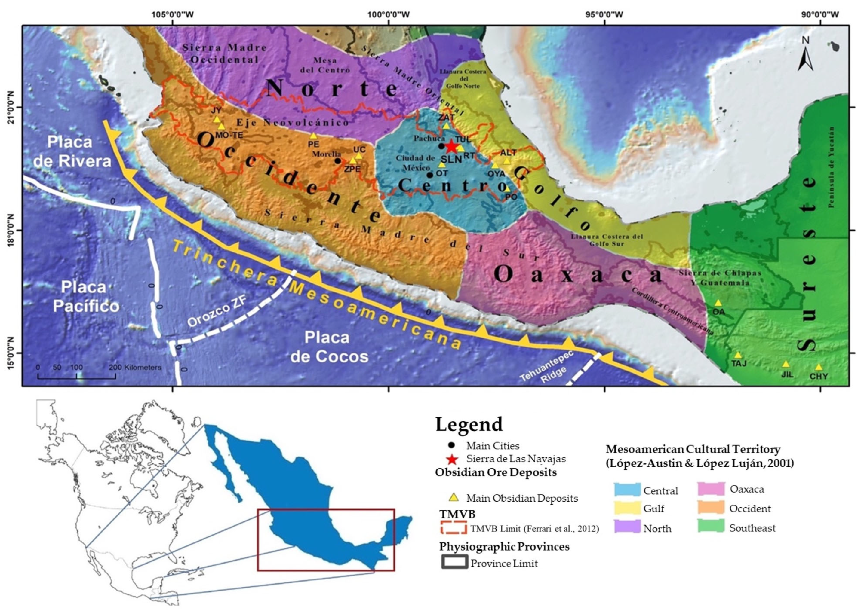
2. Materials and Methods

The characterization of obsidian identity from Cerro de las Navajas in SLN was carried out through detailed survey and sampling field work. Geological reconnaissance and mapping of the volcanic units in the southwestern region of the Sierra were conducted at the Cruz de Milagro summit and Cerro de las Navajas pr-Hispanic mine area sites (Figure 2). Sampling was performed considering only the occurrence of obsidian in each recognized lithological unit in the area, including outcrops and fronts in the underground pre-Hispanic mines. The laboratory work included petrographic, mineralogical, and geochemical analysis, considering the constitution of the petrofabric [17]. Ten key obsidian samples were selected, cut, and polished at the Laboratorio de Corte y Laminado de la Universidad de Sonora at Hermosillo, Mexico, to obtain a surface perpendicular to the volcanic stratification and parallel to the mineral lineation [17]. These samples were petrographically analyzed using a Leica Microscope (Wetzlar, Germany) and then examined with a Thermo Fisher Scientific Niton FXL portable device (Waltham, MA, USA) at the Laboratorio de Cristalografía y Geoquímica de la Universidad de Sonora at Hermosillo, Mexico, using Energy-Dispersive X-ray Fluorescence (EDXRF). Both the analytical measurement area of the equipment and the surfaces of the rock samples were cleaned with paper and alcohol to prevent contamination (e.g., dust, grease from handling, etc.).
The analysis was performed pointwise on a 1 cm2 sample, using the TEST ALL GEO method provided by the instrument manufacturer. The procedure followed that of Ochoa-Alcalá and Vidal-Solano [18], conducting three repetitions with a duration of 120 s each. The data were then evaluated following the methodology proposed by Vidal-Solano et al. [19], achieving greater reliability in the elements presented in Table 1.
Additionally, equipment was used to determine the crystalline facies of the obsidian samples to observe mineralogical variations among them. X-ray diffraction (XRD) analyses of the samples were performed using selected obsidian fragments with the highest crystal content under a 40× objective in a petrographic microscope (Figure 3). Subsequently, the selected fractions were ground with an agate mortar. Finally, analyses were carried out on a Bruker D8 Advance diffractometer over a 0–66° 2θ interval at 40 kV and 35 mA, with a step time of 13 s per step, sample rotation at 15 rpm, a 1 mm divergence slit, and a total run time of 12 h, using a wooden sample holder to achieve the highest definition in the analysis. The diffractometer has an angular range of 0–160° 2θ, angular resolution down to 0.0001° 2θ, and an X-ray source of a Cu Kα tube (50 W typical, 40 kV, 40 mA). In terms of data acquisition and analysis software, we used DIFFRAC.SUITE for instrument control and data acquisition and DIFFRAC.EVA V7 for phase identification and qualitative analysis.
Figure 2. Geoarchaeological map of the Cerro de las Navajas locality on a Digital Elevation Model (DEM). The spatial distribution of the main volcanic units, occurring as outcrops (EE1, 2, and 4) and subterranean (EE3), are marked with dashed lines; A A’ and B B’ are position of the geologic sections in López-Velarde, 2020 [20]. Additionally, the main inferred structures (fractures and/or faults) are observed, which control the geological arrangement of the area. The chronological distribution of pre-Hispanic exploitation (Pastrana, 1998) [9] and modern obsidian mining lots coincide in the same space, which is associated with the underground and interpreted mapping of the DFBC. Green dots represent underground mines; open-pit quarries are denoted as follows: MPA, Alfajayucan Pumice Mine; MPN, El Nopalillo Pumice Mine; MJ, Javier Mine. Other localities are CM, Cruz de Milagro; J, El Jarillal; C, INAH camp.
Minerals 15 00629 g002

3. Results

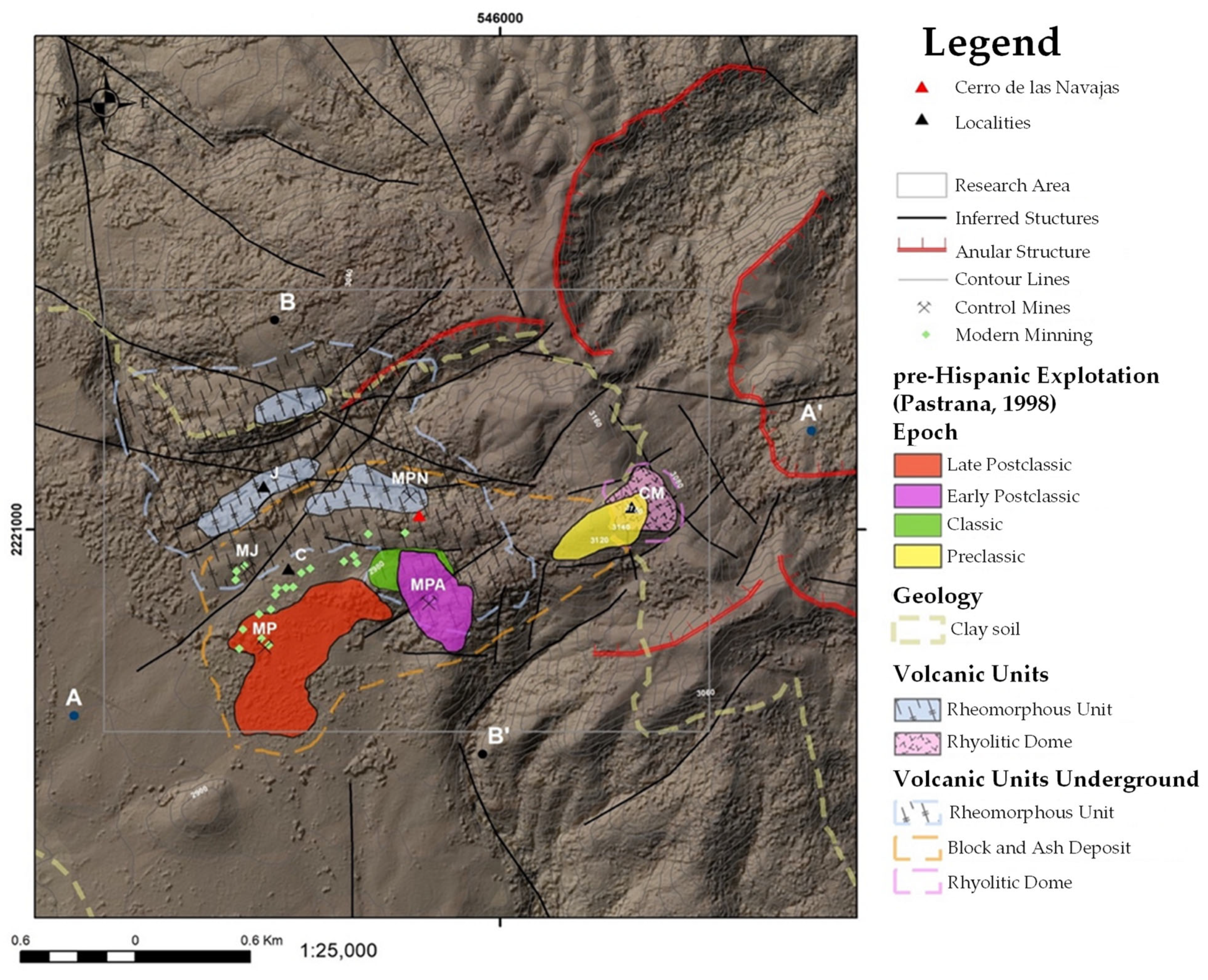
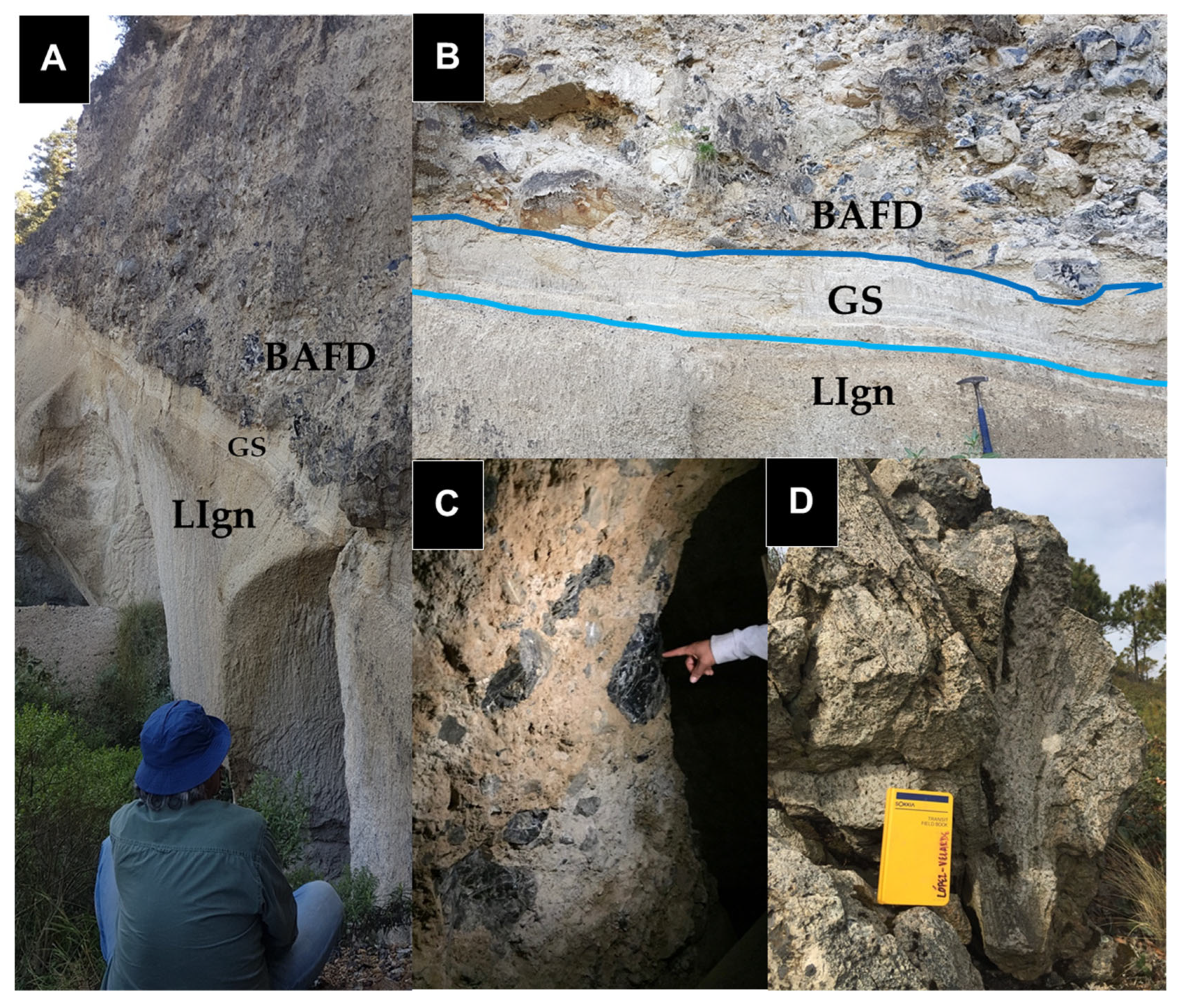
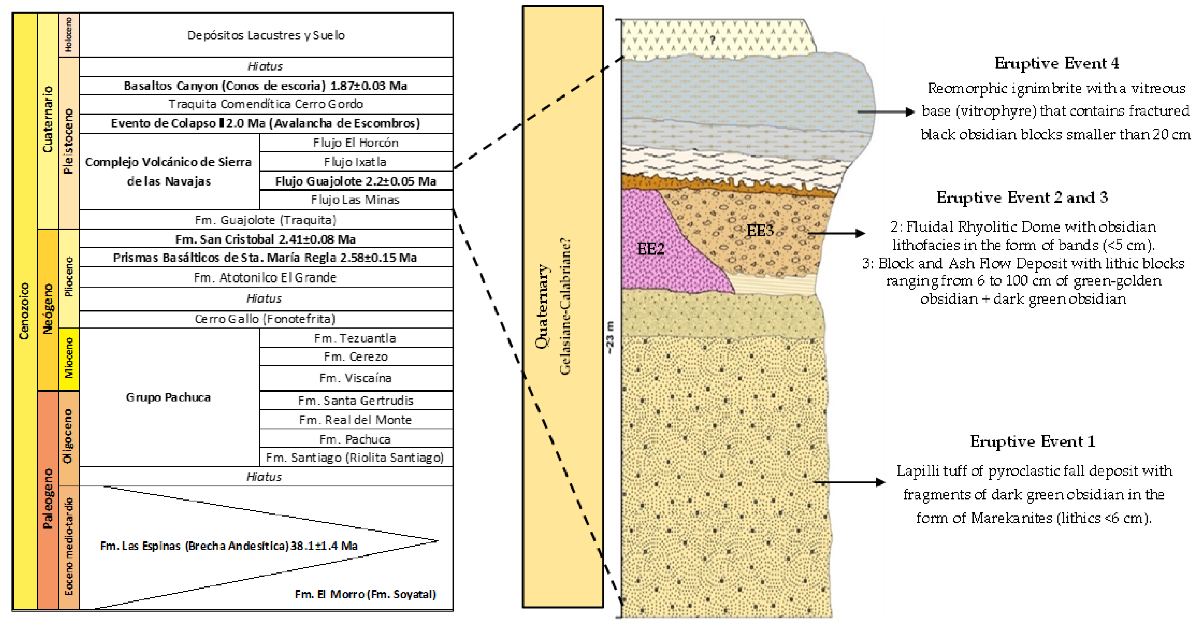
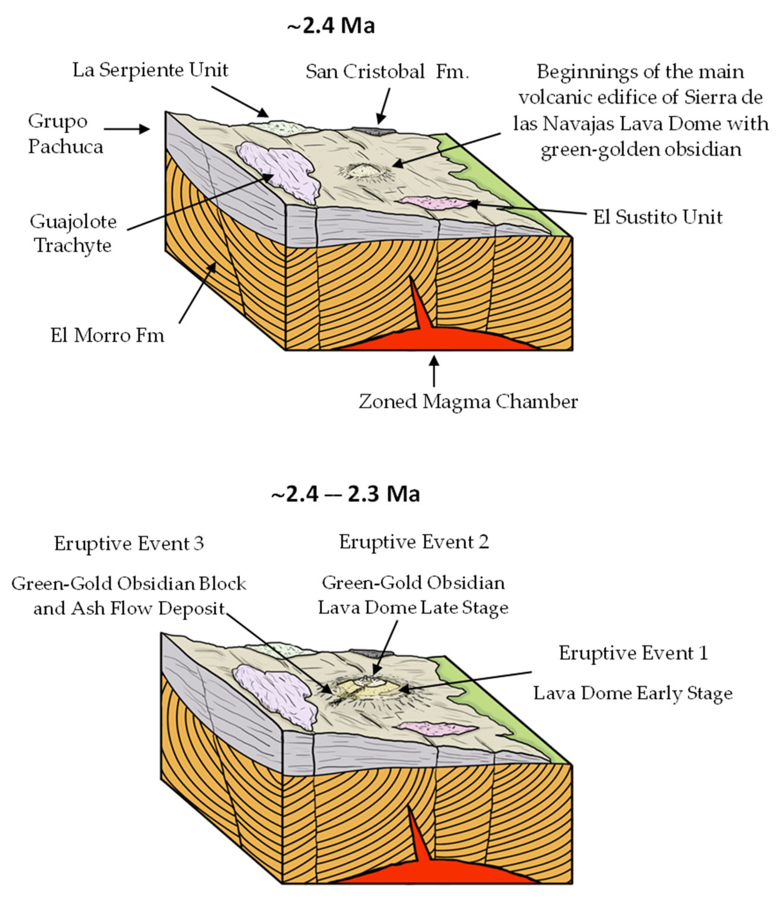
3.1. Geology of Cerro de las Navajas

Sierra de las Navajas is a paleo-stratovolcano of rhyolitic composition with a peralkaline chemical affinity. Around 2.4 million years ago, its volcanic activity led to the formation of a lava dome within the volcanic edifice [21,22]. The structural instability of the volcano caused a gravitational collapse of its northeastern flank, triggering a massive lateral eruption similar to the Mount St. Helens event [21,23]. This activity culminated around 2.0 million years ago (Figure 2).
The lava dome developed dark green-gold obsidian lithofacies, appearing as bands within the lava flow [20]. It is likely that the Cerro de las Navajas and Cruz de Milagro sites, where the most intense archaeological exploitation of the SLN deposit occurred, originated from this dome and its subsequent eruptive phases.
At Cerro de las Navajas, four distinct eruptive events (EEs) have been identified with obsidian (Figure 2): EE1 produced a Plinian-type pyroclastic deposit composed of lapilli tuff, containing marekanite obsidian fragments. EE2 is evidenced by the remnants of a fluidal rhyolitic dome with green obsidian bands (<5 cm thick; Figure 11). EE3 involved an explosive pulse that generated a Block and Ash Flow Deposit (BAFD), containing green-gold obsidian blocks ranging from 6 to 100 cm in length (Figure 4, Figure 5 and Figure 11). Finally, a fourth event (EE4) resulted in a Rheomorphic Ignimbrite unit with a glassy base (vitrophyre), characterized by highly fragmented black-grey obsidian blocks (<20 cm). This final event marks the end of volcanic activity at Cerro de las Navajas, sealing the previous deposits, and shows a distinct undefined magma vent (Figure 4).

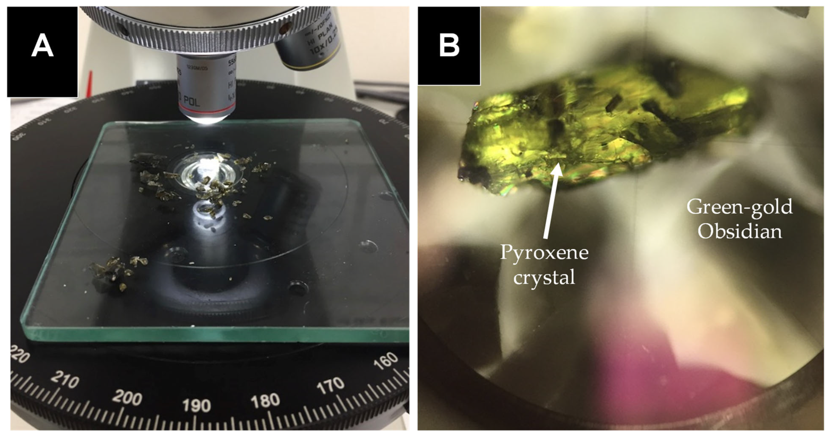
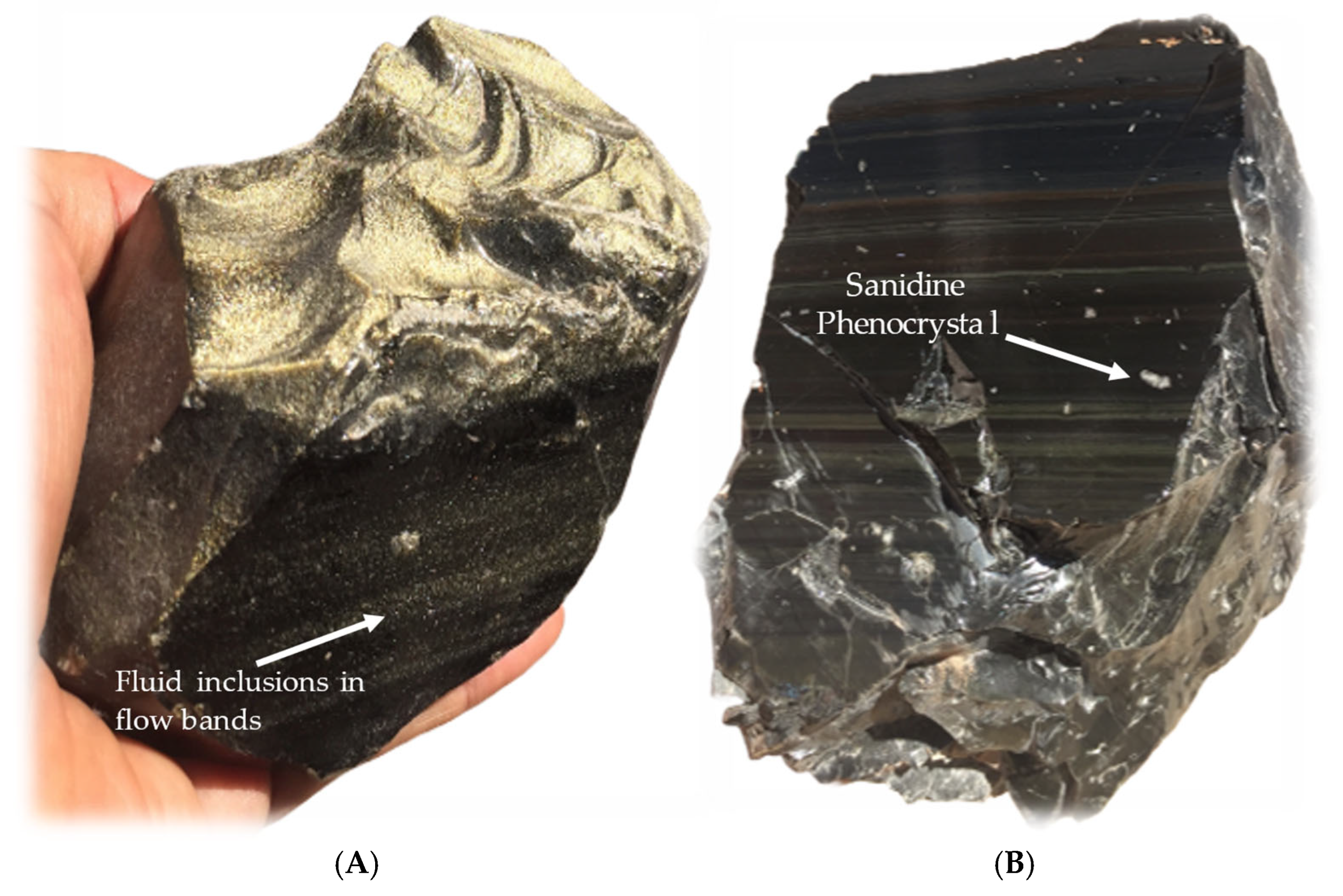
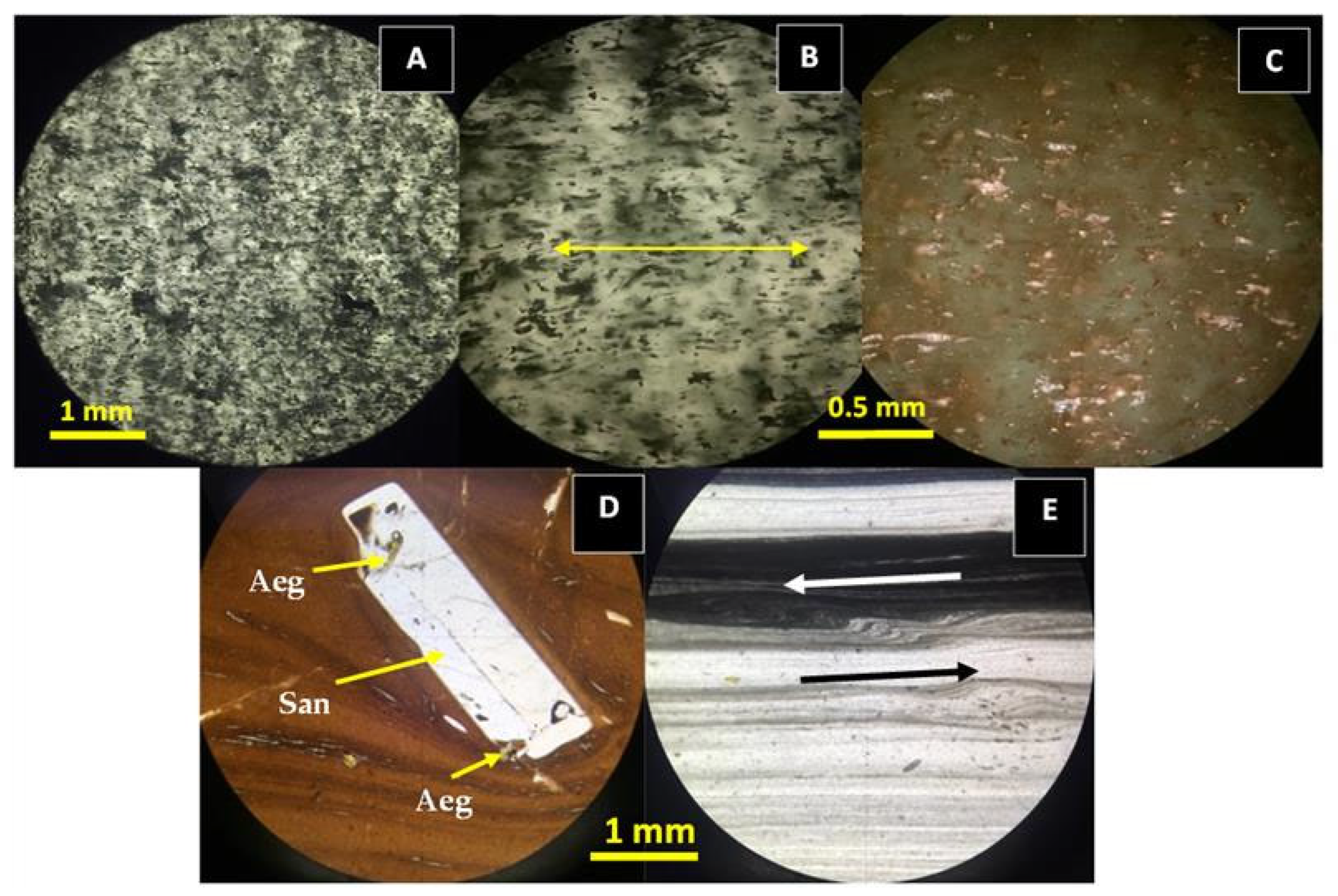
3.2. Petrography and X-Ray Diffraction
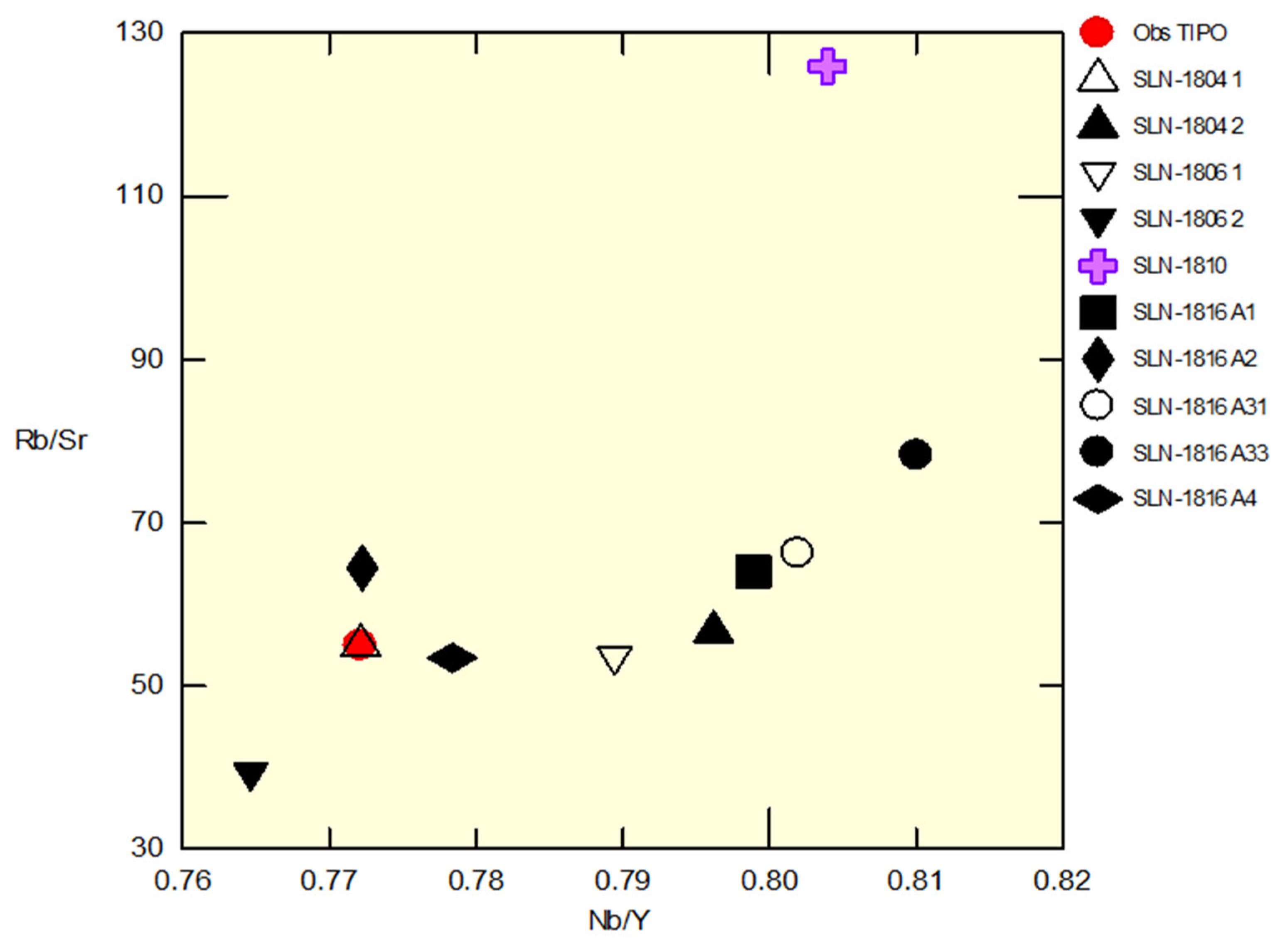
Obsidian petrographic characterization was carried out in samples of the logical units. The obsidian from blocks of the volcanic unit of EE3 exhibits varied green hues. Petrographically, these obsidians range from dark green to green-gold and are aphyric, with scarce or no phenocrysts or microphenocrysts. Notably, green-gold obsidian contains abundant fluid inclusions (<150 microns), which are angular, sometimes decrepitated, and aligned with the lava flow (Figure 6). These inclusions indicate a flow direction in the original lava.
An X-ray diffraction (XRD) analysis of EE3 obsidian samples revealed significant differences between them (Figure 7). The green-gold obsidian is primarily composed of Tridymite (Tri) + Sanidine (San) + Cristobalite (Cris), in decreasing order of abundance. Meanwhile, dark green obsidian displays a more complex mineralogical association, including Pyroxene + Tridymite + Cristobalite + Carnegieite + Quartz + Fayalite, in relative order of abundance (Figure 7). Both samples contain an unidentified mineralogical component accounting for a high percentage of their composition.
The unique black-grey obsidian sample from the last unit EE4 exhibits a distinct mineralogical composition compared to the green-gold obsidian from EE3. It is primarily characterized by the presence of feldspar phenocrysts (Anorthoclase and Sanidine). Additionally, this obsidian type lacks the unidentified component present in the EE3 samples (Figure 7).

3.3. Geochemistry

The geochemical analysis results for the different obsidian samples are shown in Table 1. A multi-elemental diagram was generated, normalizing all obsidian sample concentrations to the Cerro de las Navajas green-golden obsidian, considered as a geochemical reference standard. The diagram (Figure 8) shows significant variations in elements such as Rb, U, Th, Sr, Zn, Fe, Mn, W, Cu, and Cr, with positive and negative anomalies. However, elements such as Ti, Ca, K, Y, Mo, and V exhibit similar behavior to the reference sample, showing no significant variation.
Immobile trace element contents (Zr, Y, Nb, Ti) in SLN obsidians define their peralkaline affinity and classify them as comendites/pantellerites. This geochemical feature is unique of the obsidians from Cerro de las Navajas. The Rb/Sr and Nb/Y ratio trends indicate a positive relation in the EE3 obsidians group (Figure 9). Additionally, the EE1 marekanite sample shows a distinct Rb/Sr ratio.

4. Discussion

4.1. Concept of Subsources: Sierra de las Navajas and Color Origin in Green Obsidian

In the archaeology of obsidian deposits, the presence of subsources is common [24,25]. From an archaeological perspective, a subsource refers to a physically delimited area where lithic material is sourced. These areas are typically found within extinct volcanic edifices or complexes, forming part of a broader spatial region classified as a deposit. Subsources preserve archaeological evidence of exploitation, indicating the level of intervention and social complexity within space. They can be categorized based on color, vitreous quality, extraction type, and other factors that assign priority to different zones within a deposit. These differences arise from the natural volcanic processes that give each type of obsidian its unique physicochemical characteristics.
From a petrological perspective, a subsource is a geographically defined space with a distinct geochemical and mineralogical identity compared to its surroundings. Using non-destructive Portable X-ray Fluorescence (pXRF) analysis, trace element ratios such as Rb/Sr and Rb/Nb have been used to identify subsources within the Sardinia deposit in the Mediterranean region [26].
At SLN, raw material is distributed among at least three major subsources: El Jacal, Cruz de Milagro, and Cerro de las Navajas [9]. Each of these sites exhibits a distinct geological history associated with its volcanic formation, which defines the petrological identity of its obsidian. Differences between obsidians from different subsources may be textural, geochemical (trace element composition), or mineralogical. At Cerro de las Navajas, binary geochemical diagrams of Rb/Sr and Nb/Y have been used to identify pyroclastic deposits associated with different eruptive events (Figure 9). However, the variations in the green-gold color and chemistry of the obsidians from eruptive event 3 (EE3) correspond to the explosive nature of a single volcanic Block and Ash Flow Deposit that dispersed various glassy lithofacies from a dome.
The variation in the characteristic green coloration of the obsidian from Cerro de las Navajas is primarily controlled by Fe, with minor contributions from Cr and Mn as trace chromophores (Table 1 and Figure 8). Samples displaying higher Fe2+ contents exhibit more intense green hues, whereas increased Fe3+ correlates with brownish-olive tones, consistent with optical absorption bands centered near 1.0 μm and 0.9 μm, respectively [27]. Furthermore, abundant micrometer-scale fluid inclusion (rich in H2O–CO2–S) species enhance light scattering (Figure 6), subtly modulating the perceived color saturation and translucency [28]. Together, these compositional and physical factors explain the range of green shades observed in our samples.

4.2. Origin of Cerro de las Navajas and Green-Gold Obsidian

The volcanic evolution of the SLN dome complex follows a chronology spanning at least three stages: (1) The origin of peralkaline volcanism led to the formation of a lava dome, which produced the green-gold obsidian. (2) Consecutive explosive eruptions generated Dense Pyroclastic Currents (DPCs), dispersing green-gold obsidian blocks southwest and south-southwest. (3) The paleo-volcano was destroyed by a massive Mount St. Helens-type eruption, depositing volcanic material to the northwest and north-northwest.
The eruptive events recorded at SLN distributed obsidian from the dome across the complex in varying quantities and volumes. Each eruptive stage is generally linked to a specific obsidian exploitation area within the Sierra. Not all effusive eruptive events in SLN contain obsidian in their stratigraphy.
Several authors have studied the origin of the Sierra from volcanological and petrological perspectives [20,21,22,23]. Its peralkaline rhyolitic magmatism is considered unique within the TMVB, exhibiting characteristics associated with highly explosive and destructive volcanism. The volcanic process in the region began with the growth of a rhyolitic lava dome, producing both effusive and explosive Plinian-type eruptions, classified as EE1 [20].
Constructive and destructive episodes in the Sierra have been occurring since the volcano’s formation around 2.4 Ma (Figure 10), culminating in a large lateral eruption at 2.0 Ma [23]. Over a span of 400,000 years, various eruptive pulses shaped the active lifespan of the volcano [23]. However, the climatic and structural conditions of the edifice have led to an increased erosion rate, isolating geological outcrops beneath forest cover and thick soil layers (Figure 2). Pyroclastic volcanic rocks typically contain a matrix rich in fine volcanic ash particles, which are highly susceptible to alteration. This alteration transforms the volcanic glass into clay minerals as the ash decomposes. The humid climatic conditions of the region accelerate this transformation, as meteoric water absorbs into the ash deposits. These clays contribute to a significant soil layer covering much of the Sierra de las Navajas complex, reducing the visibility of pyroclastic outcrops (Figure 2).
Geological evidence associated with the formation of the Rhyolitic Dome with green obsidian lithofacies (Figure 2, Figure 10 and Figure 11) is located at the Cruz de Milagro site. Additionally, EE3 at Cerro de las Navajas is interpreted as the result of EE2, triggered by the gravitational collapse of the obsidian dome. This pyroclastic event is characterized as a Block and Ash Flow Deposit (BAFD) [29], where green-gold obsidian pyroclasts appear as sub-angular blocks (>6 cm <100 cm) and curved slabs, resulting from fragmentation during eruption (Figure 11). The dome eruptions caused by collapse tend to be localized. Their dispersal depends primarily on topography, with a maximum reach of approximately 1 km from the emission point [20].
Figure 11. (A) El Nopalillo pumice mine showing the stratigraphic relation between EE3 and EE1. (B) Close up of the mine wall, where the blue lines show the volcanic lithofacies limit. (C) Photograph taken inside a underground studied obsidian mine showing the obsidian blocks inside the pyroclastic breccia of the EE3 of the Cerro de las Navajas green-gold obsidian deposit. (D) Subvertical lithophysae rhyolite in Cruz de Milagro. ACFD (Block and Ash Flow Deposit), GS (Ground Surge), Lign (Ignimbritic Lapillite).
Minerals 15 00629 g011

4.3. Pre-Hispanic Exploitation of Obsidian at Cerro de las Navajas

The volume of exploitable obsidian as a natural resource varies depending on the eruptive stage to which it is associated. Understanding the geology of a metallic or non-metallic mineral deposit enhances our ability to identify the richest zones within a mineralized system. Therefore, studying SLN’s eruptive stages provides a crucial tool for understanding the natural processes that formed the deposit.
The formation of the SLN deposit is linked to the creation and subsequent destruction of a rhyolitic lava dome [23]. The entire volcanic history—including both effusive and pyroclastic processes—offers insight into the multiple eruptive stages that contributed to the archaeological deposit. The geological complexity of the site accounts for its lithic material diversity, meaning that SLN’s volcanic evolution generated multiple potential exploitation zones; these subsources were primarily differentiated by material quality.
The geological complexity of each exploited subsource is directly related to the volcano’s eruptive history. At Cruz de Milagro, archaeological evidence indicates open-pit mining. However, while the geological evidence of obsidian at Cruz de Milagro is mainly associated with EE2, pre-Hispanic exploitation of this locality likely occurred due to the presence of small EE3 outcrops.
Interest in extracting the highest-quality obsidian was concentrated at Cruz de Milagro and Cerro de las Navajas (Figure 2). The pre-Hispanic mining system in SLN was an empirically developed extraction method unique to Mesoamerica, incorporating both open-pit and underground mining techniques [9,10] (Figure 2 and Figure 11). Unlike other Mesoamerican obsidian deposits where the resource is found on the surface, at Cerro de las Navajas in SLN, obsidian deposits are buried and partially eroded (e.g., El Jacal-El Sembo area and the Cruz del Milagro summit). This has been interpreted because of the Sierra de las Navajas volcanic–structural evolution.

5. Conclusions

The most significant archaeological obsidian deposit in Mesoamerica, Sierra de las Navajas, is a volcanic complex of rhyolitic composition with a peralkaline affinity. The geochemical characteristics of its magma are rare within the TMVB province. Its eruptive episodes began with the formation of the paleo-volcanic edifice and culminated in its destruction through a large-scale Plinian (Mount St. Helens-type) lateral eruption. The complex contains subsources of obsidian with variations in vitreous material. Mineralogical and geochemical analyses confirmed differences between the obsidians from different eruptive events at Cerro de las Navajas. Specifically, EE3 represents the volcanic deposit with the highest concentration of green-gold obsidian blocks, showing archaeological evidence of pre-Hispanic underground mining and extraction. The EE3 volcanic event is a pyroclastic phenomenon classified as a Block and Ash Flow Deposit (BAFD). This type of deposit is characterized by the sedimentation of large pyroclastic rock and ash blocks. In this case, the deposit contains green-gold obsidian blocks, rhyolitic rocks, and tuffs embedded in a volcanic ash matrix. This unit is covered by a different pyroclastic density current deposit with rare black-grey obsidian that probably derives from another volcanic vent that has yet to be defined. The green-gold obsidian pyroclastic blocks, originally parts of a lava dome, exhibit a highly vitreous quality, as well as shape and volumes sought by pre-Hispanic cultures of the Central Highlands. Currently, the local economy at Sierra de las Navajas is sustained through the mining of obsidian by the inhabitants of the Ejido El Nopalillo. Traditional exploratory methods, based on trial and error, continue to be used, often guided by the remnants of pre-Hispanic mining activities.

Author Contributions

J.R.V.-S. is the corresponding author who developed the scientific proposal. He also contributed to the interpretation of geological, analytical data and the identification of the key research questions addressed in this study, as well as to the field work and redaction of the MS. A.P. is a co-author of the proposal, and defined the archaeological research problem and geoarchaeological studies conducted in Sierra de las Navajas. G.A.L.-V. contributed to manuscript writing, figure creation, and the interpretation of geological and analytical data. He was also responsible for the literature review. All authors have read and agreed to the published version of the manuscript.

Funding

This research received no external funding.

Data Availability Statement

All data are contained within the article.

Acknowledgments

We extend our gratitude to Diana Meza Figueroa for facilitating the geochemical studies at the Crystallography and Geochemistry Laboratory of the Department of Geology at the Universidad de Sonora. We also thank M.C. Abraham Mendoza for his contributions to the X-ray diffraction analyses conducted in the same laboratory. Special appreciation goes to technician Jorge Chan López for his support in preparing materials for petrographic analysis. Finally, we acknowledge and thank Luis Manuel Alva Valdivia† and his paleomag research team at the Institute of Geophysics of the National Autonomous University of Mexico for their scientific and fraternal support during the field work.

Conflicts of Interest

The authors declare no conflicts of interest.

References

  1. Cobean, R.H. Un Mundo de Obsidiana: Minería y Comercio de un vidrio volcánico en el México Antiguo. In A World of Obsidian: The Mining and Trade of a Volcanic Glass in Ancient Mexico; Instituto Nacional de Antropología e Historia: Mexico City, Mexico, 2002. [Google Scholar]
  2. Ramírez, Q.; Véronique Darras, O. Caracterización espacial de un paisaje de extracción prehispánico: El yacimiento de dacita de Las Minas, Zacapu, Michoacán. In Ancient Mesoamerica; Cambridge University Press: Cambridge, UK, 2023; pp. 1–29. [Google Scholar] [CrossRef]
  3. Breton, A. Journey to Mexico, 1893–1897: Archaeological Tours and Sketches; Methuen & Co.: London, UK, 1905. [Google Scholar]
  4. Breton, A. Sketches and Descriptions of Mexican Obsidian Artefacts. J. Anthropol. Res. 1898, 2, 112–120. [Google Scholar]
  5. Ordoñez, E. Las Riolitas de México. Bol. Inst. Geol. México 1900, 14, 7–75. [Google Scholar]
  6. Cruz-Pérez, M.; Canet, C.; Pastrana, A.; Domínguez-Peláez, S.; Morelos-Rodríguez, L.; Salgado-Martínez, E.; Krieger, P.; Martínez-Serrano, R.G. La Obsidiana Verde y Dorada del Cerro de las Navajas: Caso de Estudio Geoarqueológico en el Geoparque Mundial de la UNESCO “Comarca Minera”, Hidalgo, México (resumen). In Proceedings of the En V Simposio Latinoamericano y del Caribe de Geoparques, Trinidad, Uruguay, 4–8 November 2019. [Google Scholar]
  7. Ferrari, L.; Orozco-Esquivel, T.; Manea, V.; Manea, M. The dynamic history of the Trans-Mexican Volcanic Belt and the Mexico subduction zone. Tectonophysics 2012, 522, 122–149. [Google Scholar] [CrossRef]
  8. Lopéz, A.; Lopéz, L. Mexico’s Indigenous Past; University of Oklahoma Press: Norman, OK, USA, 2001. [Google Scholar]
  9. Pastrana, A. La Explotación Azteca de la Obsidiana en la Sierra de las Navajas; Instituto Nacional de Antropología e Historia: Ciudad, Mexico, 1998; 282p. [Google Scholar]
  10. Pastrana, A.; Domínguez, S. Cambios en la estrategia de la explotación de la obsidiana de Pachuca: Teotihuacan, Tula y la Triple Alianza. Anc. Mesoam. 2009, 20, 129–148. [Google Scholar] [CrossRef]
  11. Ponomarenko, A.L. The Pachuca obsidian source, Hidalgo, Mexico: A geoarchaeological perspective. Geoarchaeology 2004, 19, 71–91. [Google Scholar] [CrossRef]
  12. Lopez-García, P.; Argote, D.L.; Beirnaert, C. Chemometric analysis of Mesoamerican obsidian sources. Quat. Int. 2019, 510, 100–118. [Google Scholar] [CrossRef]
  13. Caretta, M.N.; Tinoco, B.L. (Eds.) Expresiones Materiales del poder en el Contexto Arqueológico del México Prehispánico; Universidad Autónoma de San Luis Potosí: San Luis Potosí City, Mexico, 2020; Bornholms Museum; El Colegio de Michoacán A.C; pp. 161–190. Available online: https://www.academia.edu/41836183/Expresiones_Materiales_del_Poder_en_el_Contexto_Arqueol%C3%B3gico_del_M%C3%A9xico_Prehisp%C3%A1nico (accessed on 28 January 2025).
  14. Campbell, S.; Healey, E.; Kuzmin, Y.; Glascock, M.D. The mirror, the magus and more: Reflections on John Dee’s obsidian mirror. Antiquity 2021, 95, 1547–1564. [Google Scholar] [CrossRef]
  15. Donato, P.; Donato, S.; Barba, L.; Crisci, G.M.; Crocco, M.C.; Davoli, M.; Filosa, R.; Formoso, V.; Niceforo, G.; Pastrana, A.; et al. Influence of Chemical Composition and Microvesiculation on the Chromatic Features of the Obsidian of Sierra de las Navajas (Hidalgo, Mexico). Minerals 2022, 12, 177. [Google Scholar] [CrossRef]
  16. Donato, P.; Barba, L.; De Rosa, R.; Niceforo, G.; Pastrana, A.; Donato, S.; Crisci, G. Green, grey and black: A com-parative study of Sierra de las Navajas (Mexico) and Lipari (Italy) obsidians. Quat. Int. 2017, 467, 369–390. [Google Scholar] [CrossRef]
  17. Vidal-Solano, J.R.; Gómez-Valencia, A.M.; Velderrain-Rojas, L.A. Prácticas de Laboratorio y Campo Para Petrología de Rocas Magmáticas; Serie Manuales de Prácticas; Universidad de Sonora: Hermosillo, Mexico, 2022; 103p. [Google Scholar] [CrossRef]
  18. Ochoa-Alcalá, D.A.; y Vidal-Solano, J.R. Geoquímica por FRX-ED semi-portátil en secciones y polvos de rocas volcánicas básicas del Mioceno superior en la región costera sur de Sonora, México: Utilidades y ventajas en la aplicación de estudios petrológicos. Actas INAGEQ V 2020, 26, 30–39. [Google Scholar]
  19. Vidal-Solano, J.R.; Gómez-Valencia, A.M.; Hinojo-Hinojo, A.; Lozano-Santa Cruz, R. Handheld X-ray fluorescence geochemical data of geological and archaeological obsidian from Sonora, Mexico. Data Brief 2020, 33, 106410. [Google Scholar] [CrossRef] [PubMed]
  20. López-Velarde, G.A. Geoarqueología de los Yacimientos de Obsidiana con Explotación Prehispánica en la Sierra de las Navajas, Hidalgo, México: Origen e Identidad Petrológica. MSc. Thesis, Departamento de Geologia, Universidad de Sonora, Hermosillo, Mexico, 2020; 177p. [Google Scholar]
  21. Lighthart, A. The Geology, Petrology and Geo-Archaeology of Sierra las Navajas, Hidalgo, Mexico. Ph.D. Thesis, Tulane University, New Orleans, LA, USA, 2001. [Google Scholar]
  22. Nuñez-Velázquez, M. Volcán las Navajas, Estado de Hidalgo: Características Geoquímicas e Isotópicas del Magmatismo Peralcalino en la Faja Volcánica Trans-Mexicana; Universidad Nacional Autónoma de México: Mexico City, Mexico, 2018. [Google Scholar]
  23. Martínez-Serrano, R.G.; Núñez-Velázquez, M.V.; Contreras-Cruz, D.; García-Tovar, G.P.; Torres-Peralta, M.A.; Solís-Pichardo, G. On the unusual presence of a Quaternary peralkaline volcanic center, rear-arc region of the Trans-Mexican Volcanic Belt eastern sector: Geochemical and isotopic characterization of the Las Navajas–Hidalgo stratovolcano. Int. J. Earth Sci. 2022, 111, 1983–2015. [Google Scholar] [CrossRef]
  24. Argote-Espino, D.; Solé, J.; López-García, P.; Sterpone, O. Obsidian Subsource Identification in the Sierra de Pachuca and Otumba Volcanic Regions, Central Mexico, by ICP-MS and DBSCAN Statistical Analysis. Geoarchaeology 2012, 27, 48–62. [Google Scholar] [CrossRef]
  25. Vicencio, A.G.; López Corral, A.; Mitrani, A.; Arciniega, A.; Carballo, D.M. Characterization of obsidian subsource variability at El Paredón, Mexico. Archaeometry 2023, 65, 1215–1231. [Google Scholar] [CrossRef]
  26. Tykot, R.H.; Glascock, M.D.; Speakman, R.J.; Atzeni, E. Obsidian Subsources Utilized at Sites in Southern Sardinia (Italy). Mater. Res. Soc. Symp. Proc. 2007, 1047, 106. [Google Scholar] [CrossRef]
  27. Cruz-Pérez, M.A.; Canet, C.; Pastrana, A.; Domínguez-Peláez, S.; Morelos-Rodríguez, L.; Carcavilla, L.; Salgado-Martínez, E.; Krieger, P.; García-Alonso, R.J.; Martínez-Serrano, R.G. Green and Golden Obsidian of “Cerro de Las Navajas”, Hidalgo (Mexico): Geoarchaeological Heritage That Deserves International Recognition. Geoheritage 2021, 13, 92. [Google Scholar] [CrossRef]
  28. Tenorio, A.; Cabral, P.; Bosch, M.; Jiménez-Reyes, S. Bulbulian. Differences in Coloured Obsidians from Sierra de Pachuca, Mexico. J. Archaeol. Sci. 1998, 25, 229–234. [Google Scholar] [CrossRef]
  29. Brown, R.J.; Andrews, G. Deposits of Pyroclastic Density Currents. In En H. Sigurdsson, The Encyclopedia of Volcanoes, 2nd ed.; Elsevier: Amsterdam, The Netherlands, 2015. [Google Scholar]
Figure 3. Example of the selection of obsidian fragments for X-ray diffraction analysis. In (A), the obsidian chips analyzed under a petrographic microscope are shown. In (B), a 3 mm chip of green obsidian with a microphenocryst of pyroxene is shown under natural light and a 40× objective.
Minerals 15 00629 g003
Figure 4. Composite stratigraphic column summarizing the eruptive events (EEs) in the Sierra de las Navajas region. In detail, it shows the stratigraphic column of the obsidian subsource at Cerro de las Navajas. The figure illustrates the main geological units with obsidian at the site, their physical characteristics, and the approximate thickness of each unit.
Minerals 15 00629 g004
Figure 5. Hand samples of obsidian from EE3 and EE4 (left and right, respectively). The main petrographic features in the samples are highlighted in the image. In (A), a lithic block of green-golden obsidian is shown, where fluid inclusions mark the flow bands in the glass. In (B), a polished surface (perpendicular to the volcanic stratification) of a fragment of black obsidian is shown, with phenocrysts of sanidine and flow bands of different colors.
Minerals 15 00629 g005
Figure 6. Photomicrographs of cross-section cuts oriented according to the flow direction of a golden obsidian from EE3. (A) = under analyzed light, a high content of angular fluid inclusions can be observed dominating the golden obsidian. (B,C) = Under analyzed light, with a higher magnification objective (10×), the occurrence of the inclusions is visible. Additionally, in (C), the optical phenomenon producing the iridescence effect is shown. The yellow arrow indicates the flow direction in the sample, identified by the fluid inclusions. In (D,E), microphotographs of the black obsidian from EE4 are shown, where in (D), a subrounded phenocryst of Sanidine with inclusions of Aegirine is observed. In (E), a flow microstructure is visible, indicated by the white and black arrows, which follows a ductile shear process occurring between lava flow planes.
Minerals 15 00629 g006
Figure 7. In (A), green-golden obsidian with a mineralogical composition of Tridymite (Tri) + Sanidine (San) + Cristobalite (Cri), in that order of abundance, according to its mineral content percentage. (B) shows dark green obsidian, with a more complex mineralogical composition of Pyroxene (Prx) + Tri + Cri + Carnegeite (Carn) + Quartz (Qz) + Fayalite (Fay), in that order of relative abundance.
Minerals 15 00629 g007
Figure 8. Multi-elemental diagram normalized to golden obsidian (SLN-1804-1 sample from the Cerro de las Navajas subsource), showing the variations between the obsidian samples with positive and negative anomalies.
Minerals 15 00629 g008
Figure 9. Binary diagram of Rb/Sr vs. Nb/Y that discriminates the samples from the eruptive events in the Cerro de las Navajas stratigraphy. The pink cross corresponds to EEI marekanite, while all the others belong to the EE3 obsidians.
Minerals 15 00629 g009
Figure 10. Geodynamic evolution model of Sierra de las Navajas. The lava dome with dark green-golden obsidian shows several eruptive stages, where EE 1, 2, and 3 manifest. Regional geology is informed by Lighthart, 2001; Núñez-Velázquez, 2018; Lopez-Velarde, 2020; and Martínez-Serrano et al., 2022 [20,21,22,23].
Minerals 15 00629 g010
Table 1. Geochemical concentrations in ppm of the EE3 obsidians from Cerro de las Navajas.
Cerro de las Navajas
Obsidians
ZrErrorSrErrorRbErrorZnErrorFeErrorMnErrorTiErrorCaErrorKErrorNbErrorYError
Green-GoldSLN-1804 11187.447.184.010.91231.584.16243.679.1717,032.26133.13958.0445.09986.7829.70693.9453.6829,324.37208.25108.442.75140.443.41
SLN-1804 21135.946.783.760.86214.003.85220.768.4715,069.73121.09847.9141.771049.3629.92663.7353.0029,010.87206.72104.932.61131.793.18
SLN-1806 11232.017.234.580.92243.644.19263.949.4017,929.23134.221002.9745.241072.0631.04603.1354.8431,657.63217.86113.982.76144.383.39
SLN-1806 21365.8111.984.891.07154.523.96390.8914.5327,562.30202.672713.25113.68975.4529.14698.5152.3228,837.29204.03116.343.14152.153.95
MarekaniteSLN-18101112.976.381.600.88199.963.55201.097.7213,670.04109.67804.7839.081161.5832.35728.4257.8031,268.45226.83101.832.45126.662.96
Dark GreenSLN-1816 A11091.176.373.260.81197.423.59200.527.7713,775.01111.75800.5839.421009.7631.76562.5953.6529,634.40212.73100.592.46125.912.97
SLN-1816 A21140.456.693.430.84214.183.82217.678.2915,143.61120.00841.1641.391013.8629.95681.2453.8130,193.29211.25104.742.58135.633.17
SLN-1816 A311071.336.322.970.80194.833.55196.017.7013,323.44109.56754.5238.771127.8530.76717.4253.7629,126.22209.2898.482.44122.802.94
SLN-1816 A331036.026.202.470.79184.763.45185.897.5112,651.31106.54766.5838.841017.9030.16725.4454.4029,374.00211.3894.712.39116.922.86
SLN-1816 A41147.736.834.200.88218.603.90227.768.6115,406.52122.63857.0542.17966.9229.60563.3952.5529,114.55208.75105.332.63135.323.23
Disclaimer/Publisher’s Note: The statements, opinions and data contained in all publications are solely those of the individual author(s) and contributor(s) and not of MDPI and/or the editor(s). MDPI and/or the editor(s) disclaim responsibility for any injury to people or property resulting from any ideas, methods, instructions or products referred to in the content.

