Article

Assessment and Promotion of Geotouristic and Geomining Routes as a Basis for Local Development: A Case Study

by
Paúl Carrión-Mero
1,2,*,
Geanella Herrera-Narváez
1,2,*,
Gricelda Herrera-Franco
3,
Emily Sánchez-Zambrano
1,2,
Josep Mata-Perelló
4 and
Edgar Berrezueta
5
1
Centro de Investigación y Proyectos Aplicados a las Ciencias de la Tierra, CIPAT-ESPOL, Polytechnic University, Escuela Superior Politécnica del Litoral (ESPOL), Campus Gustavo Galindo, Km. 30.5 Vía Perimetral, 09-01-5863 Guayaquil, Ecuador
2
Facultad de Ingeniería Ciencias de la Tierra (FICT), ESPOL Polytechnic University, Escuela Superior Politécnica del Litoral, ESPOL, Campus Gustavo Galindo Km 30.5 Vía Perimetral, 09-01-5863 Guayaquil, Ecuador
3
Facultad de Ciencias de la Ingeniería, Universidad Estatal Península de Santa Elena (UPSE), Avda. Principal La Libertad—Santa Elena, 240204 La Libertad, Ecuador
4
Departamento de Ingeniería Minera y Recursos Naturales, Universidad Politécnica de Cataluña, 08242 Manresa, Spain
5
Departamento de Infraestructura Geocientífica y Servicios, Instituto Geológico y Minero de España (IGME), C/Matemático Pedrayes 25, 33005 Oviedo, Spain
*
Authors to whom correspondence should be addressed.
Minerals 2021, 11(4), 351; https://doi.org/10.3390/min11040351
Submission received: 16 February 2021 / Revised: 17 March 2021 / Accepted: 23 March 2021 / Published: 28 March 2021
(This article belongs to the Special Issue The Role of Minerals in Cultural and Geological Heritage)

Abstract

:
Travel itineraries are fundamental in the development of tourism of a given area. Traditional thematic routes (e.g., architectural, archaeological) can be significantly improved and optimized by including geological and mining interest sites. The present study offers an analysis of the influence that inclusion of geosites or mining sites could have on the existing routes of the Zaruma-Portovelo region (Ecuador), together with a global assessment of these itineraries as the basis of fostering local development in communities of the region. The methodology consists of the following stages: (i) compilation of existing travel itineraries; (ii) analysis and assessment of those geosites and mining sites that are included in two geotouristic routes through the Spanish Inventory of Places of Geological Interest method (IELIG, acronym in Spanish), but have not been assessed previously; (iii) assessment of existing routes (two geotouristic routes and one geomining route) from a global perspective through the Geotouristic Route Assessment Matrix method (GtRAM, acronym in Spanish); and (iv) definition of strategies for the development and promotion of travel itineraries within the context of geotourism. According to the results of quantitative assessment, three new sites (both geosites and mining sites) were studied and their obtained score of interest was “High” (164/400). The existing routes achieved good results both from the geological-mining perspective “High” score of (189/400) and within a global context “Very High” score of (3.5/5). The quantitative assessment allowed us to propose improvement strategies to disseminate and use these itineraries to unfold sustainable development based on geotourism.

Graphical Abstract

1. Introduction

At the global level, in recent years, the general trend of increasing tourists has remained constant, although there are specific exceptions such as the one caused by the COVID-19 pandemic in 2020. Both scenarios (with COVID-19 and without COVID-19) must propose alternatives for an “alternative tourism” sustainable and respectful of safety, natural and cultural resources. The application of this sustainable tourism allows the generation of benefits for the communities due that takes account of its current and future economic, social and environmental impacts [1]. In addition, in the situation in which we live with COVID-19, the presentation of alternatives with the possibility of taking place outdoors is a straightforward option for the population’s economic and social development.
In general, naturalistic tourism is focused on natural environments showing their biodiversity in situ and, consequently, the territory’s geodiversity. It is possible to promote awareness and sensitivity to the environment by including bio-diversity and geodiversity, facilitating understanding and respect for nature [2,3]. From the perspective of geodiversity, geotourism offers the opportunity to understand the elements of a region’s geological heritage [4], thus constituting a basis for society’s social, economic and even cultural development [5].
Geotourism is part of alternative tourism and is defined as tourism supporting or improving its geographical character, environment, culture, aesthetics, heritage and residents’ well-being [6]. According to [7,8], geotourism bases its development on the geosystem. However, for the rapid growth and the ability to attract tourists through geotourism, its management challenges are many and diverse [9].
For the correct management and use of geotourism, it is necessary to carry out an adequate inventory and assessment of geological resources or geosites [10,11]. Geosites constitute a representation of the geological heritage and can act as a backbone to a form of tourism that combines geology, environment, culture, aesthetics, heritage and well-being of its residents in the same term [12]. Geological heritage is a general term that considers geodiversity elements with exceptional scientific value, which is why it is linked to geomorphological, petrological, mineralogical, paleontological, stratigraphic, structural and hydrogeological elements [13]. However, other values such as cultural values can be added, where the interaction between geological characteristics and cultural elements allows highlighting their importance for the communities. In this way, the relationship between geology and society is emphasized [14]. Geosites are exceptional spaces of landscape diversity and play an essential role in geotourism, for which reason these geosites and the environment must be respected through a geoconservation strategy [15]. Although most geosites are relatively robust, various anthropic activities can damage or destroy them, as well as some natural processes that can, over time, lead to their degradation. Many geosites geographically coincide with other spaces catalogued with other protection figures (natural or cultural heritage). Due to this, comprehensive and specific management of these sites is necessary [16]. Another concept directly related to geologic heritage or geoheritage is “mining heritage”. It can be defined as the total surface and subsurface mining works, hydraulic and transport facilities, machinery, documents or objects related to former mining activities with a historical, cultural or social value [17].
In general, the geological aspect is the main attraction for visitors in the so-called geoparks, an area of special geoscientific significance with its natural attributes according to the United Nations Educational, Scientific and Cultural Organization (UNESCO) definition [18]. The geological and mining heritage benefits the community, the environment, structures and other elements. Currently, in Ecuador, there is no legal recognition for a declaration of Mining Heritage; worldwide, many of these heritages are under the figure of Natural Heritage [19].
The geological routes (georoutes) are itineraries that aim to the geological heritage’s value through the connection of different geosites. These geological routes connect geosites in a sequential and orderly manner to represent a given sector’s geodiversity. These tours are self-guided and designed to know the natural space’s characteristics through a route where stops are established. Materials such as information panels, explanatory brochures and a guide, allow the correct interpretation of the places visited. Examples of these georoutes can be found in Spain such as the “la pizarrilla” geotrails, in Jaén [20]; the geotrails in the Yanhuitlán Geopark, in the Mixteca Alta-Oaxaca (Mexico) [21]; the “Ruta Escondida”, in Ecuador [22]; the “Trans-Pyrenean Geological Route”, in France [23]; the Palaeontological heritage of mammoths through a cross-country thematic route, in Servia [24]; the “Valley of Castles”, in Kazakhstan [25]; in Morocco, three routes describing the main geosites in rural areas of Demnate and High-Tessaout valley [26]. When the georoutes also have a mining component of interest, they are called geomining routes [27].
According to [28,29], geological-tourist routes (geotourism) are itineraries that present, geological interest sites together with sites of archaeological, architectural and agricultural interest. Through the Mineral Routes and Sustainability Project (RUMYS, acronym in Spanish), it was possible to promote these routes, spreading the mining geological heritage and other sites (architectural, archaeological, cultural). These are the “Ruta del Oro” of the Southwest of Colombia (Nariño sector) [27]; the “Ruta de las Piritas” in Huelva, Spain [30]; the “Ruta de la Sal- Camí Cardoner” in the south of France [31]; the “Estrada Real” in Brazil [32]; the “Ruta de la piedra” and “Ruta del mármol” in Portugal [33]; and “Ruta del Oro” in Ecuador [34]. These routes are strategic places that provide opportunities for the sustainable development of their inhabitants and their cultural, geographical environments, considering geotourism as a strategic sector that takes advantage of nature’s resources.
According to [18], Ecuador lacks a specific law related to geoconservation. However, there are general regulations for the conservation of some components linked to the elements of geoheritage. Some legal documents that may be relevant when establishing geoheritage protection strategies in Ecuador are (a) Policy Constitution of the Republic of Ecuador (20 October 2008) [35]; (b) Organic Law of Culture (27 December 2016) [36]; (c) Organic Code of the Environment (12 April 2017) [37].
In Ecuador, the National System of Protected Areas (SNAP) [38] is focused on conserving and taking advantage (e.g., tourism) of biological diversity and genetic resources in 56 protected natural areas of its territory. The geological heritage located within a protected area is considered elements of nature preserved by national laws, although, on the other hand, they are complementary accessories of territory with high biological diversity [18]. In general, the tourist attraction of the geological heritage in the population is limited to territories under the SNAP jurisdiction. However, the new geopark initiatives include geosites and geological heritage as the basis of geotourism, among other aspects.
In Ecuador, tourism is considered the third source of non-oil income according to the Directorate of Economic Analysis, General Coordination of Statistics and Research [39]. Ecuador has several declarations of world heritage: in 1978, UNESCO declared Quito as the first Cultural Heritage City of Humanity and recognizes the Galapagos Islands and the Sangay National Park as Natural Heritage [40,41]. In 1983, the historic center of Cuenca and Qhapaq Ñan were included within the cultural heritage and the Zápara language, straw hats and marimba music as intangible heritage [42]. In addition, it has the first UNESCO World Geopark called “Imbabura Geopark” [43] and other Geopark projects such as Tungurahua, Napo-Sumaco, Santa Elena Peninsula, Puyango and Ruta del Oro [44,45,46]. It should be noted that there is currently an initiative of the Ruta del Oro Geopark Project that considers itineraries or routes in the context of their development [34,47,48]. The latter contemplates the geological-mining, archaeological and natural heritage of the canyons of the upper part of the El Oro province such as Zaruma, Portovelo, Atahualpa, Chilla and Piñas. Various authors have studied the Zaruma-Portovelo area in the context of its geological heritage [19,33]. Specifically, sites of geological interest have been evaluated using methods based on criteria including scientific value, educational value, cultural value, aesthetic values, ecological value, potential use-value, recreational value, risk of degradation, economic value, touristic attraction value, protection and functional value [47].
The main objective of this contribution is to offer an analysis of the influence that inclusion of geosites, mining sites and other sites (e.g., cultural, architectonic) could have on the existing routes of the Zaruma-Portovelo region (Ecuador), together with a global assessment of these itineraries as the basis of fostering local development in communities of the region.

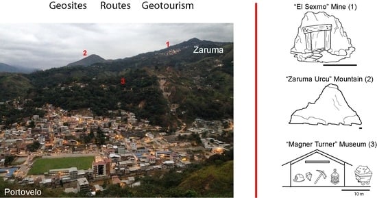
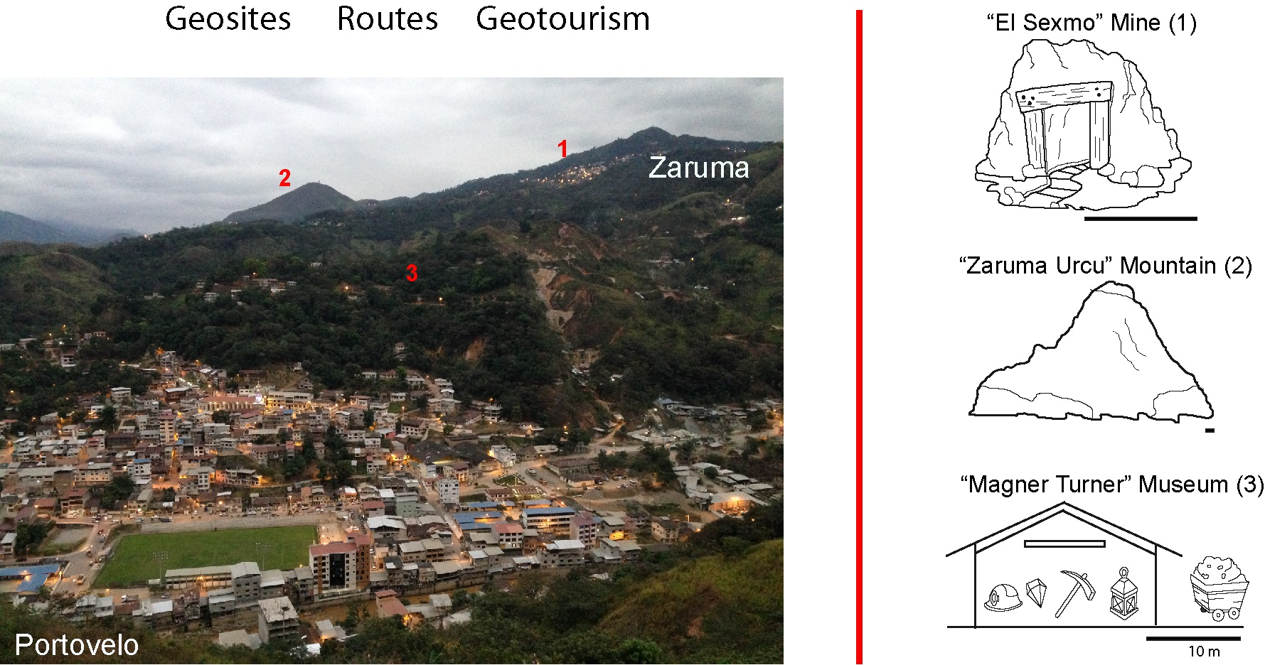
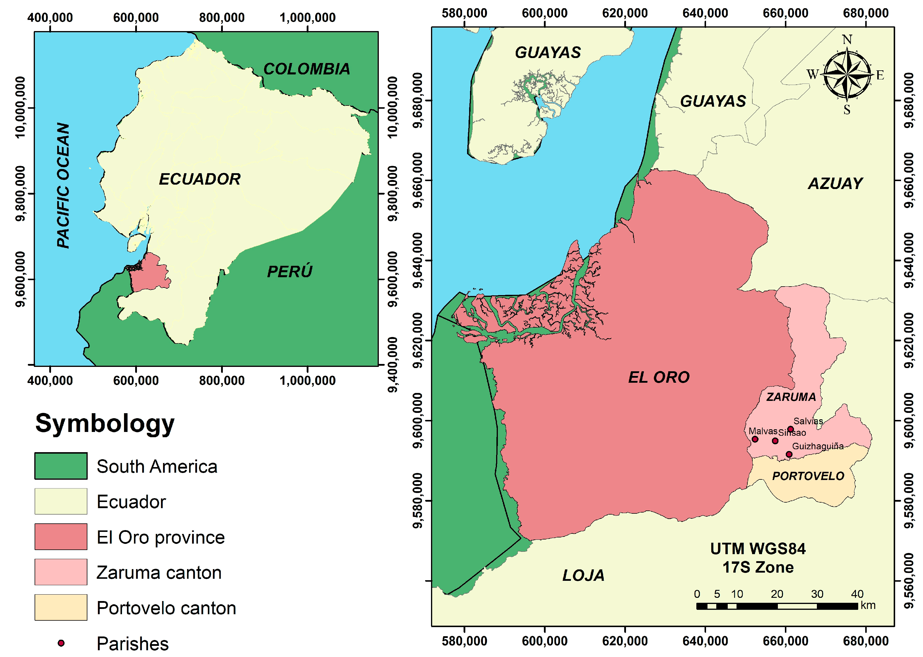
2. Study Zone Setting

The study area corresponds to the Zaruma-Portovelo area (Figure 1). It is located in the south of Ecuador, in the upper part of the El Oro province and occupies approximately 1000 km2. From the orographic point of view, the relief of the territory presents an average elevation of 1200 m.a.s.l., includes the western part of the Andean mountains (Chilla Ridge) and is located within the upper-middle section of the Puyango river basin [49].
From a geological perspective (Figure 2), this area (mining district, specifically) on metamorphic, igneous and sedimentary rocks ranging from the Precambrian-Paleozoic to the Quaternary age [50]. The basement rocks are metamorphic (Triassic). Above them, massive andesitic lavas are unconformably intruded by small plutons of diorite to granodiorite composition (Lower Cretaceous). Felsic volcanic lavas, pyroclastics and rhyolitic flows (Tertiary-Miocene) cap unconformably all of these units. Finally, Quaternary alluvial and colluvial deposits can be recognized along the Amarillo and Calera river [51]. In addition, it has geological structures, such as faults, that follow an E–W direction, which is considered a northern and eastern Andean system, in which the predominant direction is NNE [52,53]. Reliefs characterized mainly by a marked fluvial activity and the absence of stratovolcanoes stand out. The highest areas (e.g., hills and mountains) are extremely irregular and occupy igneous terrains of Cretaceous or Tertiary ages, of intrusive or effusive origin [54].
According to [50], this area’s mineralization originated from collapse and post collapse rhyolitic activity. Zaruma-Portovelo area is part of the epithermal vein-system (Zaruma-Portovelo). This epithermal vein-system results from hydrothermal processes close to a Miocene volcano that produced an andesitic to a dacitic sequence. In detail, felsic volcanic lavas, pyroclastics and rhyolitic flows. The minerals identified are typical of intermediate sulfurization epithermal gold vein deposits, where three stages of mineralization are distinguished: quartz-pyrite, quartz-polymetallic and quartz-carbonate [55,56]. The dominant minerals in the sector are pyrite, chalcopyrite, sphalerite and galena. Other forms of occurrence are bornite, hematite, tetrahedrite, molybdenite and electro [53].
Historically, mining in this sector had its origins in the pre-Columbian and pre-Inca era. Currently, gold mining continues in exploitation. This district is the oldest and most important gold mining area in Ecuador. At the beginning of the 20th century, mining was carried out by the South American Development Company (SADCO, New York; NY, USA). Later, the Ecuadorian state directed the mine and artisanal and small-scale mining is currently, carried out [57,58].
On the whole, Zaruma, Portovelo, Piñas, Atahualpa (Paccha) and Chilla cantons have approximately 35,000 inhabitants. Mining directly employs between 6000 and 10,000 people [54]. Zaruma and Portovelo are known as the country’s first mining regions and are currently considered the state’s cultural heritage [34].
On the tourism side, the Zaruma-Portovelo sector has increased the number of visits by national and international tourists and with it, the local economy, due to new tourism practices in terms of culture, gastronomy, geology, mining history and archaeology of the sector, especially in the parishes of Malvas, Sinsao, Salvias and Guizhaguiña. These places have focused on various studies and are reflected in the local tourism department’s annual tourist registration. A significant figure is the approximately 9000 annual visits that El Sexmo mine has been registering in the last four years [48]. El Sexmo mine is one of the leading offers for geotourism in the area and its management is part of the collaboration with the society of the Bienes Raices S.A. mining company (BIRA S.A., Zaruma, Ecuador). However, a disadvantage to tourism development is illegal mining that generates environmental problems and terrain instability [3,59].

3. Materials and Methods

The applied analysis and evaluation process consists of four phases (Figure 3). Phase I consists the compilation and categorization of routes proposed in previous works and selecting the inventoried geosites on these routes. This phase was focused on the characterization of two geotourism routes that we will call: Geotourism Route I (GT-I), proposed by [60] and Geotourism Route II (GT-II) proposed by [61]. The Geomining Route III (GM-III) information proposed and valued by [34] also is considered. The data comes from the academic research project “Propuesta de Geoparque Ruta del Oro y su incidencia en el desarrollo territorial” (“Ruta del Oro” Geopark proposal and its impact on territorial development) under grant to “Centro de Investigación y proyectos aplicados a las Ciencias de la Tierra (CIPAT, Guayaquil, Ecuador)” with the project CIPAT-02-2018. This project began in 2018 and is valid until 2022. There are several reports, degree theses and publications in collecting information where there were already justifiable references to the routes.
The geotourism routes (GT-I and GT-II) include geosites, mining sites and other (architectural, archaeological, gastronomic) in their itinerary. In the case of the geomining route (GM-III), it geosites and mining sites.
Phase II consists evaluating the geosites and mining sites included as itineraries in the geotourism routes (GT-I and GT-II), using the Spanish Inventory of Places of Geological Interest method (IELIG, acronym in Spanish) [62]. This international methodology was selected because it was applied on the geomining route (GM-III), which serves as a reference in other Ecuador studies and other articles [63,64]. In general, this methodology is based on the intrinsic value of the geosite and the use-value. The assessment is carried out through an expert qualification and the follow-up of a specific procedure [49] to obtain three degrees of principal interest, such as scientific (Ci), didactic (Di) and tourist (Ti). The average of the three interest rates gives a global value (Gv) of each geosite. From each geosite and mining sites values, the global value is obtained from the geological and mining point of view of each of the two geotourism routes. The IELIG methodology being the best categorized and known at the geological interest level, qualifying the possible geosites in the valuation ranges according to their interests Ci, Di and Ti. According to the scores, the parameters evaluated in [62] vary from 0, 1, 2 and 4, with 0 being the lowest score and 4 the highest. This value is multiplied by the weight of each of the interests given in the methodology [62] and the total sum of these gives the value of each interest. If the place of geological interest exceeds the value 266 points, it is considered a place of “Very High” interest, scores between 134 and 266 will be of “High” interest and those below 134 points will be considered of “Medium” interest. The results of this methodology serve as a guide for evaluating the route in the next phase.
Phase III refers to the assessment of the three geotouristic routes (two geotouristic routes GT-I and GT-II and one geomining route GM-III) assessed by applying the Geotouristic Route Assessment Matrix method (GtRAM, acronym in Spanish) based on Criteria of Geological relevance, Representativeness, Geotouristically prominent Site, Interpretation and Conservation method (GREGSIC) [65]. This method consists of evaluating qualitative parameters (accessibility to the site, preparation and logistics, formal registration, among others) of each of the sites (geosite, mining site, archaeological site, architectural site) in an itinerary, assigning it a range of numerical evaluation (Table 1). With the results obtained, the representative value of each of the three routes considered is estimated.
In this study, the five parameters mentioned above are scored qualitatively and quantitatively in a range included from (1–5), where (1–1.9) is considered as “Low”, (2–2.9) “Medium”, (3–3.9) “High” and (4–5) “Very High”. Once all the sites that make up the route have been evaluated, give the GtRAM value to the integrated geotourism route.
For the qualification, the criteria of some experts in the area, or others, who know the area are valued. The final evaluation of the routes is carried out by the co-authors of the work, considering the geosites that compose them using the IELIG method and the GtRAM method to evaluate them in the general context of the route. These two evaluation methods were used in this work to design the new route proposed by the authors. The IELIG method was necessary because there were three sites on the routes studied (one mining site in GT-I and two geological sites in GT-II) that were not evaluated in previous studies and included in this work. The GtRAM method is based on more tourist characteristics, according to what the Ministry of Tourism in Ecuador (MINTUR, acronym in Spanish) considers having a site registered as of tourist interest. The GtRAM method contributes to the valuation of geotourism routes or geomining routes, which can be applied anywhere with an integrating and global context vision.
In phase IV, the proposal for a new geotourism route is presented in the first place, which includes the sites with the best evaluation obtained in previous phases (I, II and III). Finally, development strategies carried out through the analysis of strengths, opportunities, weaknesses and threats (SWOT) are presented for the use of all the routes characterized in this study, (two previous geotourism routes GT-I and GT-II, a geomining route previous GM-III and a new geotourism route proposed). Then, the promotion of geotourism routes is presented in the context of geotourism [66,67].

4. Results

4.1. Selection of Information

The summarized inventory of the routes (Routes GT-I, GT-II and GM-II) with the description of the sites that make them up, the definition of the type of sites and other characteristics, are presented in Table 2. Among the most representative sites in the study area, the Centro de Zaruma (historic downtown) (Figure 4a), the El Sexmo mine at a geological level (Figure 4b), the Magner Turner mineralogical museum at a mining level (Figure 4c) and Los Arcos hill (Figure 4d). The itineraries in map format of the three compiled routes are presented in the supplementary material (Figures S1–S3).
On the GT-I geotourism route, eleven sites were defined, of which 63.6% correspond to geosites and mining sites. On the GT-II geotourism route, eighteen sites appear as part of its itinerary, of which 55.5% correspond to geosites and mining sites. It is essential to indicate that one geological interest site and one mining site appear on both routes. When comparing the geosites of the geotourism routes GT-I and GT-II referring to the geomining route GM-III (Ruta del Oro), it contains five geosites and a mining site assessed by the IELIG method. In total, in the two initial routes (GT-I and GT-II), two geosites and one mining site are computed without evaluating.
Because geosites and mining sites require good facilities to be considered a tourist destination by MINTUR, Table 3 shows some criteria and information for each route studied, such as length, degree of difficulty due to physical conditions, addressees of the tourist offer, level of security in the mining facilities and their surroundings and access routes.

4.2. Quantitative Assesment

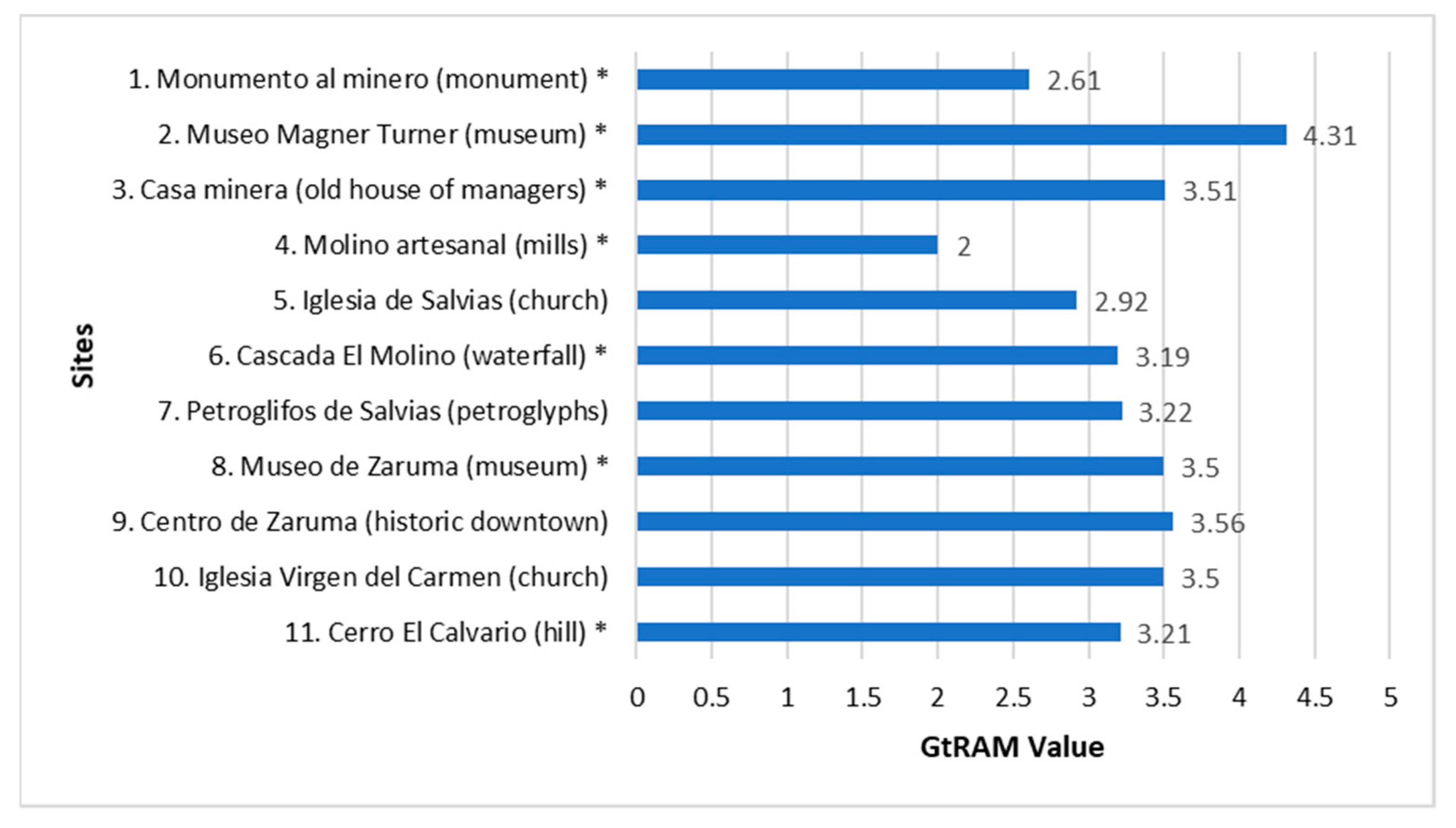
Assessment of Pending Geosites by IELIG Method

The valuation of three geosites and mining sites not previously evaluated and that make up the GT-I and GT-II routes were carried out using the IELIG methodology and are presented in Figure 5. The mining site of the GT-I route “Mills of the mines” reached a Gv of 163 which qualifies it as “High” interest because it represents Portovelo’s mining history. In detail, this mining site is an old metallurgical plant with a crushing mill, where the ore was treated for the extraction of metals. The geosites of the GT-II route Molinos de San Antonio (mills) and Cerro Chiva Turco (hill) have a Gv of 144 and 184, respectively, categorized as “High” interest for both geo-sites. Molinos de San Antonio (mills) brings a cultural identity to the town of San Antonio. While the Cerro Chiva Turco (hill), characterized as a rocky mass, provides remarkable support to the development of flora and fauna in the study area.
Figure 6 shows the average Gv of the IELIG evaluation for each of the three routes studied. For this, the valuation of the geosites (previously estimated and estimated in this work) was used. All the GT-I, GT-II (evaluated in this work) and GT-III (evaluated in previous work, [34]) routes are located at a “High” interest with a Gv of 179, 188 and 199, respectively. Route GT-I, of eleven sites only seven are geosites and mining sites, in route GT-II of eighteen sites, nine are geosites and mining sites and on route GM-III, all six are geosites and mining sites.

4.3. Quantitative Analysis and Assesment

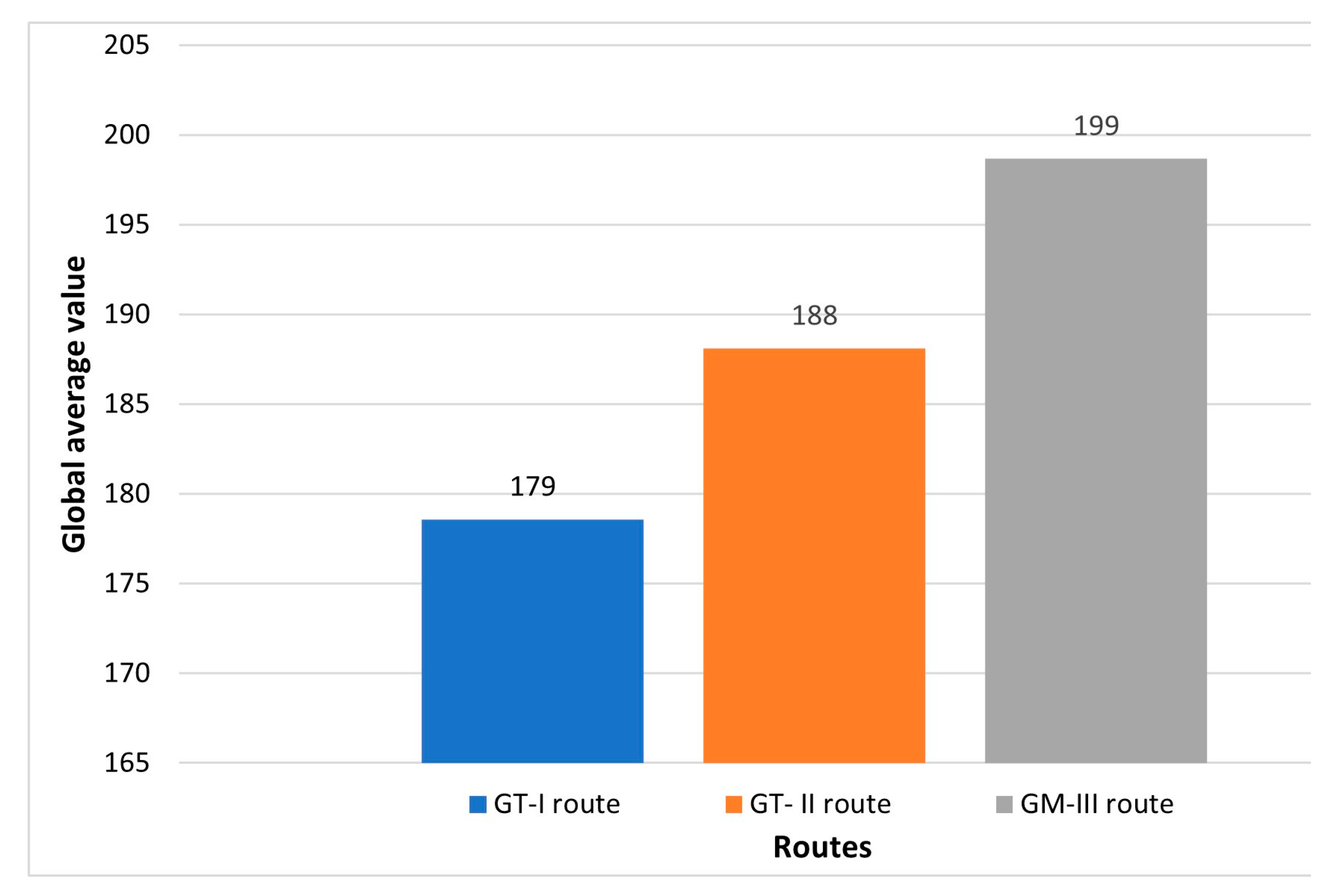
Route Assessment by GtRAM Method

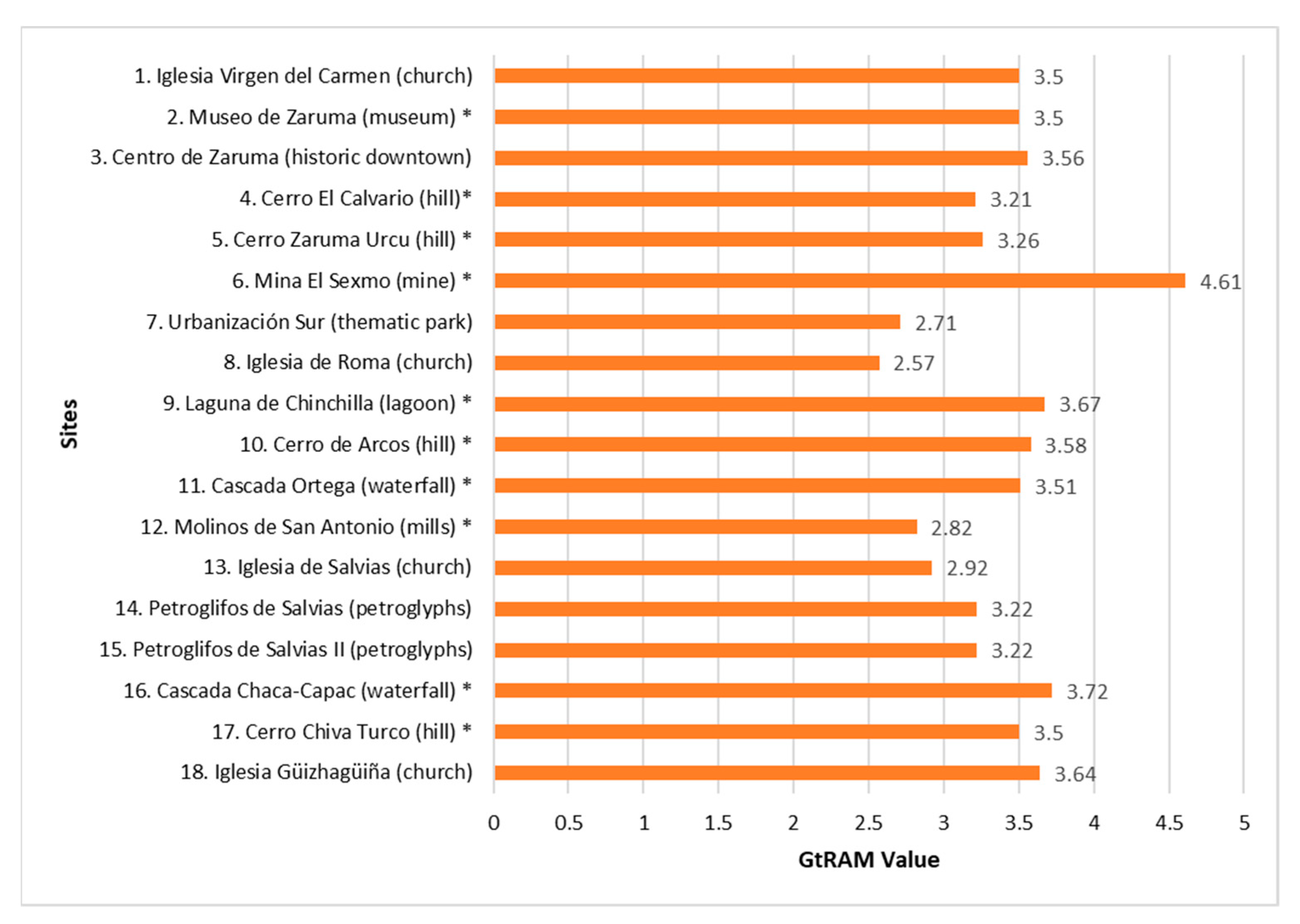
  • GtRAM applied to the GT-I route
Through the GtRAM method evaluations of the eleven sites that make up the GT-I route, it was obtained that: one of them presents a “Very high” value (e.g., Museo Magner Turner (museum)); seven sites included in this route have a “High” value (e.g., Casa Minera (old house of managers)); two sites have a “Medium” value (e.g., Monumento al minero (monument)). Therefore, Route I achieves an average GtRAM rating of 3.23/5, as shown in Figure 7.
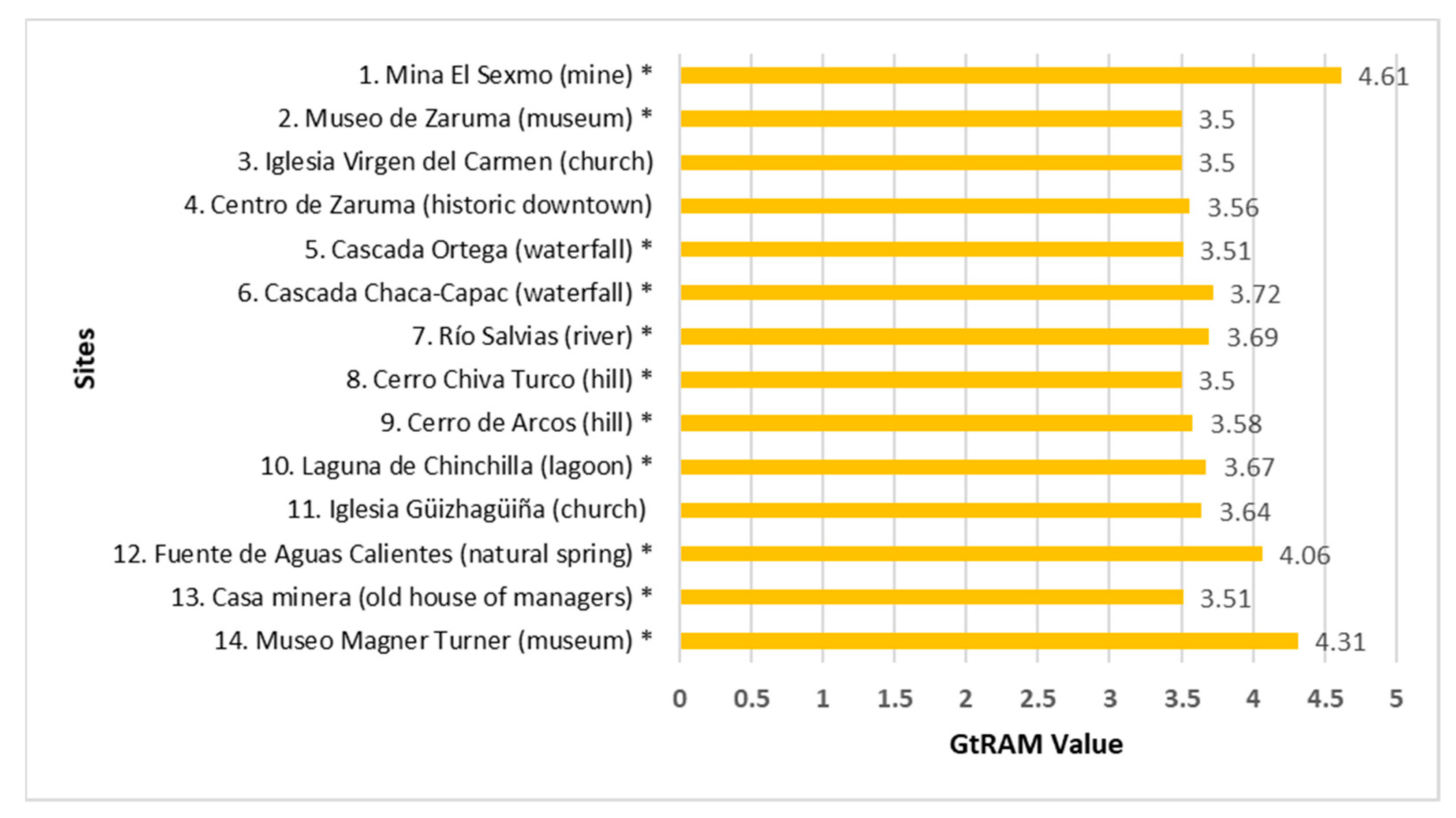
  • GtRAM applied to the GT-II route
The application of the GtRAM method on the eighteen GT-II sites made it possible to define that one of these sites has a “Very High” value (e.g., Mina El Sexmo (mine); thirteen sites have a “High” value (e.g., Museo de Zaruma (museum)); and four sites a value of “Medium” (e.g., Molinos de San Antonio (mills)). Therefore, Route II has an average GtRAM rating of 3.37/5. These are shown in Figure 8.
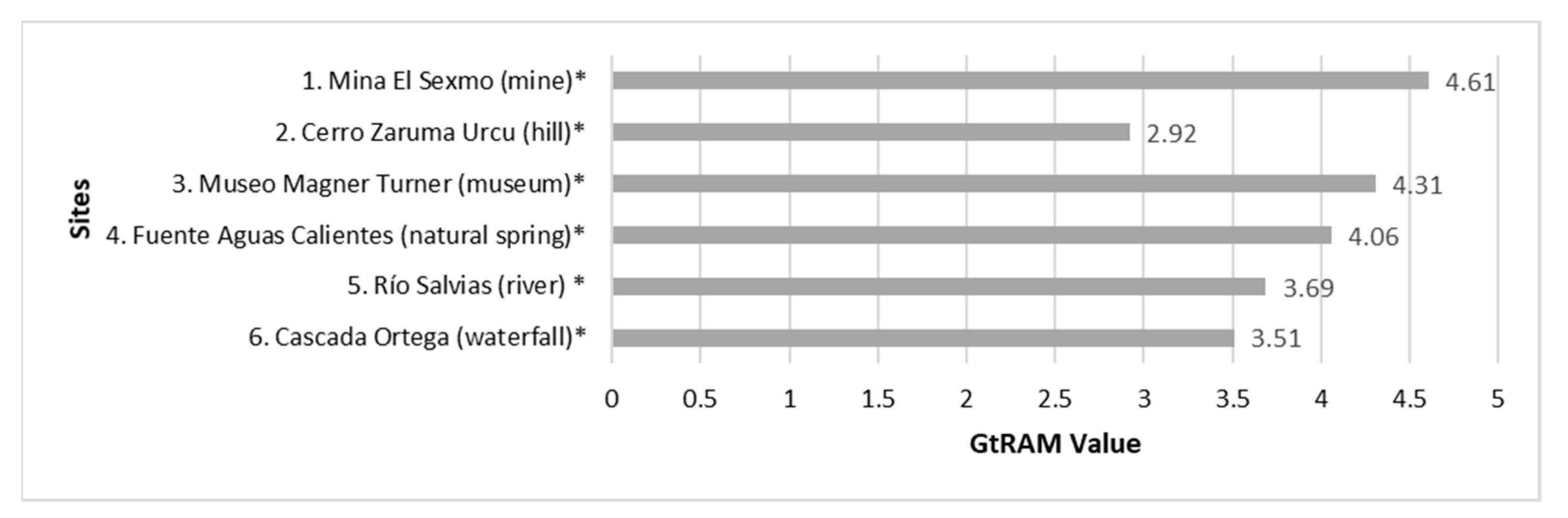
  • GtRAM applied to the GM-III route
The evaluation of Route GM-III using the GtRAM method allows defining that: three sites have a “Very High” assessment (e.g., Fuente Aguas Calientes (natural spring)); two have a “High” value (e.g., Río Salvias (river)) and one site has a “Medium” value (e.g., Cerro Zaruma Urcu (hill)). Therefore, Route III takes an average GtRAM rating of 3.85/5, which is observed in Figure 9.

4.4. New Route and Strategies

4.4.1. The Geodiversity Route

A new route was defined from the best-valued sites (GtRAM Method) in the existing routes (The Geodiversity). Figure 10 shows the sites that make up the route “The Geodiversity”, represented by fourteen sites with outstanding architectural, natural and cultural values. The route also based its design on complying with the concept of sustainability and attending to logistics and transport facilities for its use (visit). With the GtRAM method, the route reaches a “High” value of 3.74/5.
The map of the new route “The Geodiversity” contemplated in Figure 11 includes the fourteen selected sites. The route covers the cantons of Zaruma-Portovelo of approximately 90 km, which could be covered in three days. In Zaruma, places from 1 to 11 are visited (Figure 10) and in Portovelo, geosites from 12 to 14 (Figure 10). All these places have excellent geotourism potential in the area, with a GtRAM value greater than and equal to 3.5/5.
It is also essential to indicate that the Geodiversity route contains eleven geosites and mining sites, which reach a global value (Gv) of 192, is considered “High” interest according to the IELIG method. Of the fourteen sites that make up this new route, one of them was valued in this work: Cerro Chiva Turco (hill).

4.4.2. Strengths, Weaknesses, Opportunities and Threats (SWOT) Analysis

From phase IV, an analysis and SWOT matrix was obtained, which was developed through a participatory method of a focus group made up of authorities, the tourism department and the community about the Ruta del Oro Geopark project, which allowed us to determine the strategies development in all routes analyzed through GtRAM. It is considered that the new possible geosites and mining sites included in the proposed route should enter into a conservation and adaptation plan to carry out the geotourism activity, due to their high impact on the mining history of the Portovelo canton as indicated in Table 4.
Based on the SWOT matrix, it can be considered implemented immediately to value and enhance geotourism is to promote it recreationally, raising awareness among the inhabitants of the cantons and national visitors and foreigners of the importance of conservation of the mining geological heritage and the opportunities for sustainable development it represents. In addition, seek support from public and private entities in charge of tourism management to obtain a registry of tourist and recreational interest sites, thus being recognized nationally and internationally.
The sites with the lowest valuation are GT-I (Old house of SADCO managers, El Molino Waterfall), GT-II (Ortega Waterfall, San Antonio Grinding), GT-III (Ortega Waterfall, Salvias River), Geodiversity route (Old house of SADCO managers, Ortega Waterfall). Given their importance, they are considered in the strategies for their adaptation and improvement.
On the other hand, it is essential to take actions based on the cantons’ and parishes’ infrastructure to provide better organization. More attention should be paid to the redesign or adaptation of the roads, the spaces used for people and cars’ movement.

5. Interpretation of Results and Discussion

The methodological process has made it possible to define the geological and mining heritage’s interest in the Zaruma-Portovelo sector and its geosites and mining sites through internationally recognized procedures (IELIG and GtRAM methods). The IELIG method is widely used in Ecuador [63] and Latin America [68]. The GtRAM matrix (based on GRESCIC) constitutes a valuation method focused on logistics, tourism and heritage aspects [34]. In general, using methodologies has made it possible to generate an average value for the different routes studied and thus determine their global interest from a geological, mining, cultural and heritage point of view.
Regarding the results obtained, the GtRAM Method’s application in the new route (Geodiversity) proposed that the route’s evaluation reaches a valuation of 3.74. This route’s valuation is higher than those previously estimated for GT-I and GT-II routes (Figure 7 and Figure 8). However, it is similar to the estimate made on GM-III (Figure 9) since their designs are similar, although incorporating cultural sites of great relevance in the area is noteworthy in this new route. Finally, it is essential to highlight that it is essential to have an adequate individual characterization of each of the evaluated sites to obtain this assessment type.
With the analysis obtained through the SWOT matrix, Geodiversity route can contribute to the social and economic development of the Zaruma and Portovelo area. Specifically, it becomes clear that an activity such as geotourism is a suitable alternative in post-mining management of the area. Ruta del Oro Geopark project integrates the different economic activities that characterize these sectors and the province. It is also essential to add the mining legacy and preserve geo-diversity, eco-museums, or cultural parks in strategic places with its inhabitants’ civic participation in a natural and cultural environment. All this will allow tourists to appreciate, understand and manage the community’s heritage and its artisan work in a way that contributes to sustainable development [28,69]. The geotourism routes are an essential stimulus to know and enjoy nature’s values and represent an opportunity to develop their peoples [20,27].
In general, the application of an assessment methodology of geosites or routes (all geosites) as the one exposed in this work or as those approached in other works [23,24,26], could provide a crucial information for present and future of the route. In detail, to identify which areas and sites require more attention in order to protect the geosites and attract a larger number of tourists in the future.

6. Conclusions

The research carried out in this article indicates an essential presence of sites, both of geological interest and other interests (e.g., architectural and archaeological), with the possibility of being offered as tourist itineraries (geotourism routes and geomining routes). The new route proposed in the area, using the best-rated sites, is the so-called Geodiversity route. This represents a new development alternative for a population rich in heritage and ample job opportunities for its inhabitants.
The application of the valuation methods for geosites (IELIG method), complemented with the proposed methodology, which especially values the tourist facilities section, for all sites (GtRAM method), allowed to define their interest in a representative and comparable with that of other sites of interest in the country or region. The SWOT analysis and the TOWS matrix applied showed that creating a new route or promoting existing ones would favor socioeconomic development in the study area. However, it is essential to take the appropriate legal and financial measures to materialize the proposed alternatives’ viability.
The routes valued starting from the proposal of several works. In comparison, the final proposed route tries to integrate aspects of geoheritage with cultural themes of this area. The routes analyzed (GT-I, GT-II and GT-III) were developed in different initiatives, but additionally, there are cultural and tourist traditions, which integrate points of gastronomic, architectural and cultural traditions or festivals. The proposals for geotourism routes or geomining routes are focused on geological sites, mining sites and sites of a cultural nature. Therefore, there is the possibility of developing new projects integrating new values or sites to these routes.
The new proposed route called Geodiversity is elaborated based on the development and strategic models, visualized in international routes in Asia and Europe, in Geopark projects. The experiences in these places offer implementation alternatives adapting to the mining reality of the sector.

Supplementary Materials

The following are available online at https://www.mdpi.com/article/10.3390/min11040351/s1, Figure S1: Geotouristic Route GT-I: Portovelo-Salvias-Zaruma Circuit. * Geosites/mining sites. Based on [60], Figure S2: Geotouristic Route GT-II: Thematic map “In search of an adventure”. * Geosites/mining sites. Based on [61], Figure S3: Ruta Geominera GM-III: Suggested itinerary, within “Ruta del Oro”, selecting several geosites and mining sites. * Geosites/mining sites. Based on [34].

Author Contributions

Conceptualization, P.C.-M., G.H.-F. and G.H.-N.; methodology, P.C.-M., E.B., J.M.-P. and G.H.-F.; software, G.H.-N. and E.S.-Z.; formal analysis, P.C.-M. and G.H.-N.; investigation, P.C.-M., G.H.-F., E.B., J.M.-P. and G.H.-N.; data curation, G.H.-F. and G.H.-N.; writing—original draft preparation, G.H.-F., G.H.-N. and E.S.-Z.; writing—review and editing, P.C.-M., G.H.-F., G.H.-N. and E.S.-Z.; visualization, G.H.-N. and E.S.-Z.; supervision, P.C.-M., E.B. and G.H.-N.; project administration, P.C.-M. and G.H.-N.; funding acquisition, P.C.-M. All authors have read and agreed to the published version of the manuscript.

Funding

“This research was funded by “Propuesta de Geoparque Ruta del Oro y su incidencia en el desarrollo territorial” (“Ruta del Oro” Geopark proposal and its impact on territorial development) under grant us CIPAT-02-2018, “Registro del Patrimonio Geológico y Minero y su incidencia en la defensa y preservación de la geodiversidad en Ecuador” (Registry of Geological and Mining Heritage and its impact on the defense and preservation of geodiversity in Ecuador) under grant nos CIPAT-01-2018 and BIRA S.A. Company.

Data Availability Statement

Not Applicable.

Acknowledgments

This work has been possible thanks to support from Bira Bienes Raíces S.A., Zaruma Rotary Club, Zaruma Municipality, Portovelo Municipality and Research Deanship by ESPOL. This work is based on previous initiatives sponsored by the Red Minería XXI (CYTED: 310RT0402, IGME). To Fanny Condo (MINTUR, acronym in Spanish) and Mariela Moncayo (Professor at the Universidad del Pacífico), for their contribution to the development of the work, contributing their experience in the areas of geodiversity and tourism. Many thanks for Tatiana Berrezueta, Ingrid Villafuerte y Alice Barrezueta. Those who developed the proposals of Routes that we consider here in very well supported works.

Conflicts of Interest

The authors declare no conflict of interest.

References

  1. Duxbury, N.; Bakas, F.E.; Vinagre de Castro, T.; Silva, S. Creative Tourism Development Models towards Sustainable and Regenerative Tourism. Sustainability 2020, 13, 2. [Google Scholar] [CrossRef]
  2. Ciftci, Y.; Güngör, Y. Proposals for the Standard Presentation of Elements of Natural and Cultural Heritage Within the Scope of Geopark Projects. Bull. Miner. Res. Explor. 2016, 153, 223–238. [Google Scholar] [CrossRef] [Green Version]
  3. Frækaland Vangsnes, G. The meanings of mining: A perspective on the regulation of artisanal and small-scale gold mining in southern Ecuador. Extr. Ind. Soc. 2018, 5, 317–326. [Google Scholar] [CrossRef]
  4. Carcavilla, L.; Durán, J.J.; López-Martínez, J. Geodiversidad: Concepto y relación con el patrimonio geológico. Geo-Temas 2008, 10, 1299–1303. [Google Scholar]
  5. Carcavilla, L.; Belmonte, Á.; Durán, J.J.; Hilario, A. Geoturismo: Concepto y perspectivas en España. Enseñ. Cienc. Tierra 2011, 19, 81–94. [Google Scholar]
  6. Hose, T.A. 3G’s for Modern Geotourism. Geoheritage 2012, 4, 7–24. [Google Scholar] [CrossRef]
  7. Dowling, R.K.; Newsome, D. Geotourism: The Tourism of Geology and Landscape; Goodfellow Publishers: Oxford, UK, 2010; ISBN 978-1-906884-09-3. [Google Scholar]
  8. Dowling, R.K. Global Geotourism—An Emerging Form of Sustainable Tourism. Czech J. Tour. 2013, 2, 59–79. [Google Scholar] [CrossRef] [Green Version]
  9. Newsome, D.; Dowling, R.; Leung, Y.-F. The nature and management of geotourism: A case study of two established iconic geotourism destinations. Tour. Manag. Perspect. 2012, 2–3, 19–27. [Google Scholar] [CrossRef]
  10. Liverman, D. Geodiversity—Valuing and Conserving Abiotic Nature. Can. Geogr./Géogr. Can. 2006, 50, 412–413. [Google Scholar] [CrossRef]
  11. Mazzoni, E.; Diez, P. Potencialidad del geoturismo en la Patagonia: Sitios de interés geológico en proximidad de la Ruta Nacional 40, tramo Río Turbio—Lago Viedma, Santa Cruz. Ser. Correl. Geol. 2018, 34, 56–79. [Google Scholar]
  12. Declaración de Arouca. Available online: http://www.europeangeoparks.org/?p=223 (accessed on 24 March 2021).
  13. Brilha, J. Inventory and Quantitative Assessment of Geosites and Geodiversity Sites: A Review. Geoheritage 2016, 8, 119–134. [Google Scholar] [CrossRef] [Green Version]
  14. Palacio Prieto, J.L. Geositios, geomorfositios y geoparques; importancia, situación actual y perspectivas en México. Investig. Geogr. 2013, 2013, 24–37. [Google Scholar] [CrossRef] [Green Version]
  15. Mirari, S.; Aoulad-Sidi-Mhend, A.; Benmlih, A. Geosites for Geotourism, Geoheritage, and Geoconservation of the Khnefiss National Park, Southern Morocco. Sustainability 2020, 12, 7109. [Google Scholar] [CrossRef]
  16. Prosser, C.D.; Díaz-Martínez, E.; Larwood, J.G. The Conservation of Geosites. In Geoheritage; Elsevier: Amsterdam, The Netherlands, 2018; pp. 193–212. [Google Scholar]
  17. Nita, J.; Myga-Piateck, U. Geotourism potential of post-mining regions in Poland. Bull. Geogr. 2014, 7, 138–156. [Google Scholar] [CrossRef] [Green Version]
  18. Sánchez-Cortez, J.L.; Simbaña-Tasiguano, M. Los geoparques y su implantación en América Latina. Estud. Geogr. 2019, 79, 445. [Google Scholar] [CrossRef]
  19. Carrillo Cevallos, F.H. Planeamiento Geológico Minero Aplicado al Desarrollo Sustentable a la Ruta del Oro. Bachelor’s Thesis, The Escuela Superior Politécnica del Litoral (ESPOL), Guayaquil, Ecuador, 2009. [Google Scholar]
  20. Cantero-Quesada, J.M. Territorio, turismo y senderos temáticos: El caso de Baños de la Encina, Jaén. In Patrimonio Cultural y Desarrollo Territorial; Thomson Reuters Aranzadi: Cizur Menor, Spain, 2016; pp. 277–308. [Google Scholar]
  21. Palacio Prieto, J.L.; de Castro Martínez, G.F.; González, E.M.R. Geotrails in the mixteca alta UNESCO Global Geopark, Oaxaca, Mexico. Cuad. Geogr. 2019, 58, 111–125. [Google Scholar]
  22. Carrión-Mero, P.; Ayala-Granda, A.; Serrano-Ayala, S.; Morante-Carballo, F.; Aguilar-Aguilar, M.; Gurumendi-Noriega, M.; Paz-Salas, N.; Herrera-Franco, G.; Berrezueta, E. Assessment of Geomorphosites for Geotourism in the Northern Part of the “Ruta Escondida” (Quito, Ecuador). Sustainability 2020, 12, 8468. [Google Scholar] [CrossRef]
  23. Venzal, C.A. Tourism analysis of a geological route. Seven sections of the Trans-Pyrenean. Geological Route in Aspe valley (France). Cahiers de Geographie du Quebec 2013, 57, 333–357. [Google Scholar] [CrossRef] [Green Version]
  24. Antić, A.; Pomić, N.; Dordević, T.; Marković, S.B. Promoting Palaeontological Heritage of Mammoths in Serbia Through a Cross-Country Thematic Route. Geoheritage 2021, 13, 1–16. [Google Scholar] [CrossRef]
  25. Nigmatova, S.; Zhamangara, A.; Bayshashov, B.; Abubakirova, N.; Akmagambet, S.; Berdenov, Z. Canyons of the charyn river (South-East Kazakhstan): Geological history and geotourism. Geoj. Tour. Geosites 2021, 34, 102–111. [Google Scholar] [CrossRef]
  26. Bouzekraoui, H.; Barakat, A.; El Youssi, M.; Touhami, F.; Mouaddine, A.; Hafid, A.; Zwoliński, Z. Mapping geosites as gateways to the geotourism management in central High-Atlas (Morocco). Quastiones Geogr. 2018, 37, 87–102. [Google Scholar] [CrossRef] [Green Version]
  27. Delgado-Martínez, A.M.; Pantoja-Timarán, F. Structural analysis for the identification of key variables in the Ruta del Oro, Nariño Colombia. Dyna 2015, 82, 27–33. [Google Scholar] [CrossRef]
  28. Pereira, M.B.; Ferreira, A.C.; Rocha, L.C. Trilha Interpretativa Geoturística na Serra de São José no Entorno da Estrada Real/MG. Anuário Inst. Geociênc. UFRJ 2012, 35, 165–172. [Google Scholar] [CrossRef]
  29. Carrion-Mero, P. Proyecto Rumys: Cooperación y Sostenibilidad. In La Plata en Iberoamérica, Siglos XVI al XIX: Congreso Internacional; Universidad de León: León, Spain, 2008; pp. 687–700. [Google Scholar]
  30. González-Martínez, A.; Carvajal Gómez, D.J. Pasivos ambientales mineros y su valorización como recurso patrimonial. Ejemplo de actuaciones en la Comarca de Tharsis (Faja Pirítica Ibérica). In Taller Sostenibilidad; CETEM: Río de Janeiro, Brasil, 2013; pp. 5–29. [Google Scholar]
  31. Obiols-Perearnau, L.; Mata-Perelló, J.; Restrepo-Martínez, C.; Pasques-Canut, J. Rutas de la Sal. El “Camí Cardoner”, vía de distribución de la sal de las Minas de Cardona hacia el Sur de Francia. In Rutas Minerales en Iberoamérica; CYTED: Guayaquil, Ecuador, 2009; pp. 77–83. [Google Scholar]
  32. Pires, M. “A “Estrada Real” e a história do processo de construção de roteiros turísticos no estado de Minas Gerais, Brasi. Tur. Desarro. Local 2017, 10, 1–10. [Google Scholar]
  33. Mata-Perelló, J.; Carrión, P.; Molina, J.; Villas-Boas, R. Geomining Heritage as a Tool to Promote the Social Development of Rural Communities. In Geoheritage; Elsevier: Amsterdam, The Netherlands, 2018; pp. 167–177. [Google Scholar]
  34. Carrión Mero, P.; Herrera Franco, G.; Briones, J.; Caldevilla, P.; Domínguez-Cuesta, M.; Berrezueta, E. Geotourism and Local Development Based on Geological and Mining Sites Utilization, Zaruma-Portovelo, Ecuador. Geosciences 2018, 8, 205. [Google Scholar] [CrossRef]
  35. Ecuador. Asamblea Nacional Constituyente; Constitución Política del Ecuador: Quito, Ecuador, 2010. [Google Scholar]
  36. Ecuador. Asamblea Nacional; Ley Organica de Cultura: Quito, Ecuador, 2016. [Google Scholar]
  37. Ecuador. Asamblea Nacional; Código Orgánico del Ambiente: Quito, Ecuador, 2017. [Google Scholar]
  38. National System of Protected Areas (SNAP). Sistema Nacional de Áreas Protegidas del Ecuador. Minietrio del Ambiente y Agua. República del Ecuador. Available online: http://areasprotegidas.ambiente.gob.ec/es (accessed on 12 March 2021).
  39. Reyes Vargas, M.; Manjarrez Fuentes, N.; Ortega Ocaña, A. La Gestión del turismo comunitario en el marco de la economía popular y solidaria en Ecuador. Tur. Y Desarro. Local. 2014, 17, 3–9. [Google Scholar]
  40. Figueroa, M.F. El Control de Tráfico Ilícito de Bienes Culturales Patrimoniales, Normativa y Participación Legal de las Instituciones Públicas Correspondientes. Master’s Thesis, Instituto de Altos Estudios Nacionales (IAEN), Quito, Ecuador, 2005. [Google Scholar]
  41. Molina, E. Estudio comparativo de los sitios Ramsar en el Ecuador como oferta turística del Patrimonio Natural del Ecuador. Rev. Tur. Desarro. Buen Vivir 2012, 3, 45–81. [Google Scholar]
  42. Guzmán, T.L.G.; Trigo, J.P.; Gálvez, J.C.P.; Pesantez, S. El patrimonio inmaterial de la humanidad como herramienta de promoción de un destino turístico. Estud. Perspect. Tur. 2017, 26, 568–584. [Google Scholar]
  43. Arellano Guerrón, S.L.; Arroyo Mera, D.M.; Carrión Albuja, E.A.; Merizalde Leiton, C.E. Geoparques mundiales de la UNESCO y su importancia en el desarrollo sostenible de las comunidades. Estudio de caso: “Geoparque Imbabura”. Siembra 2019, 6, 93–108. [Google Scholar] [CrossRef]
  44. La Serna Gómez, A.M.; Rhea González, B.S.; Vasallo Villalonga, Y. Estrategias para el desarrollo sostenible y sustentable del Geoparque Imbabura, Ecuador. Explor. Digit. 2019, 1, 61–70. [Google Scholar] [CrossRef]
  45. Carrión, P.; Mata, J.; Romero, P.; Espinoza, T. Geoparque en Ecuador. In Proceedings of the Conference: Seminario Internacional sobre Patrimonio Geológico y Minero, Machala, Ecuador, 7–9 June 2012. [Google Scholar]
  46. Carrión-Mero, P.; Morante-Carballo, F. The Context of Ecuador’s World Heritage, for Sustainable Development Strategies. Int. J. Des. Nat. Ecodyn. 2020, 15, 39–46. [Google Scholar] [CrossRef]
  47. Herrera-Franco, G.; Carrión-Mero, P.; Morante-Carballo, F.; Herrera-Narváez, G.; Briones-Bitar, J.; & Blanco-Torrens, R. Strategies for the development of the value of the mining-industrial heritage of the Zaruma-Portovelo, ecuador, in the context of a geopark project. Int. J. Energy Prod. Manag. 2020, 5, 48–59. [Google Scholar] [CrossRef]
  48. Carrión-Mero, P.; Loor-Oporto, O.; Andrade-Ríos, H.; Herrera-Franco, G.; Morante-Carballo, F.; Jaya-Montalvo, M.; Aguilar-Aguilar, M.; Torres-Peña, K.; Berrezueta, E. Quantitative and Qualitative Assessment of the “El Sexmo” Tourist Gold Mine (Zaruma, Ecuador) as A Geosite and Mining Site. Resources 2020, 9, 28. [Google Scholar] [CrossRef] [Green Version]
  49. Schütte, P.; Chiaradia, M.; Barra, F.; Villagómez, D.; Beate, B. Metallogenic features of Miocene porphyry Cu and porphyry-related mineral deposits in Ecuador revealed by Re-Os, 40Ar/39Ar, and U-Pb geochronology. Miner. Depos. 2012, 47, 383–410. [Google Scholar] [CrossRef] [Green Version]
  50. Van Thournout, F.; Salemink, J.; Valenzuela, G.; Merlyn, M.; Boven, A.; Muchez, P. Portovelo: A volcanic-hosted epithermal vein-system in Ecuador, South America. Miner. Depos. 1996, 31, 269–276. [Google Scholar] [CrossRef]
  51. Kennerley, J.B. Hoja Geológica Zaruma 38 CT-NVI-E Escala 1:100,000; Instituto Geográfico Militar (Ed): Quito, Ecuador, 1980. [Google Scholar]
  52. Bonilla, W. Metalogenia del Distrito Minero Zaruma-Portovelo, República del Ecuador. Ph.D. Thesis, Universidad de Buenos Aires, Buenos Aires, Argentina, 2009. [Google Scholar]
  53. Berrezueta, E.; Ordóñez-Casado, B.; Bonilla, W.; Banda, R.; Castroviejo, R.; Carrión, P.; Puglla, S. Ore Petrography Using Optical Image Analysis: Application to Zaruma-Portovelo Deposit (Ecuador). Geosciences 2016, 6, 30. [Google Scholar] [CrossRef] [Green Version]
  54. Tarras-Wahlberg, N. Environmental management of small-scale and artisanal mining: The Portovelo-Zaruma goldmining area, southern Ecuador. J. Environ. Manag. 2002, 65, 165–179. [Google Scholar] [CrossRef] [Green Version]
  55. Chiaradia, M.; Fontboté, L.; Beate, B. Cenozoic continental arc magmatism and associated mineralization in Ecuador. Miner. Depos. 2004, 39, 204–222. [Google Scholar] [CrossRef] [Green Version]
  56. Schutzmeier, P.; Berger, U.; Bose-O’Reilly, S. Gold Mining in Ecuador: A Cross-Sectional Assessment of Mercury in Urine and Medical Symptoms in Miners from Portovelo/Zaruma. Int. J. Environ. Res. Public Health 2016, 14, 34. [Google Scholar] [CrossRef] [Green Version]
  57. Adler Miserendino, R.; Bergquist, B.A.; Adler, S.E.; Guimarães, J.R.D.; Lees, P.S.J.; Niquen, W.; Velasquez-López, P.C.; Veiga, M.M. Challenges to measuring, monitoring, and addressing the cumulative impacts of artisanal and small-scale gold mining in Ecuador. Resour. Policy 2013, 38, 713–722. [Google Scholar] [CrossRef]
  58. Veiga, M.M.; Angeloci, G.; Hitch, M.; Colon Velasquez-Lopez, P. Processing centres in artisanal gold mining. J. Clean. Prod. 2014, 64, 535–544. [Google Scholar] [CrossRef]
  59. Aguilar Aguilar, M.; Blanco Torrens, R.; Borja Bernal, C.; Briones Bitar, J.; Carrión Mero, P.; Morante Carballo, F. Caracterización geomecánica y análisis de las afectaciones del macizo rocoso en el casco urbano de Zaruma, Ecuador. In Proceedings of the 17th LACCEI International Multi-Conference for Engineering, Education, and Technology: “Industry, Innovation, and Infrastructure for Sustainable Cities and Communities”, Latin American and Caribbean Consortium of Engineering Institutions, Montego Bay, Jamaica, 24–26 July 2019. [Google Scholar]
  60. Villafuerte-Holguin, I.; Barrazueta-Quevedo, A. Desarrollo Turístico de la Ruta del Oro y su Área de Influencia en los Cantones Zaruma y Portovelo. Bachelor’s Thesis, The Escuela Superior Politécnica del Litoral (ESPOL), Guayaquil, Ecuador, 2005. [Google Scholar]
  61. Berrezueta-Alvarado, T. Análisis Turístico de la Ruta Zaruma Guizhaguiña. Bachelor’s Thesis, The Escuela Superior Politécnica del Litoral (ESPOL), Guayaquil, Ecuador, 2006. [Google Scholar]
  62. García, A.; Carcavilla, L. Documento Metodológico para la Elaboración del Inventario Español de Lugares de Interés Geológico (IELIG); Inventario Español de Lugares de Interés Geológico (IELIG): Madrid, Spain, 2014. [Google Scholar]
  63. Morante-Carballo, F.; Herrera-Narváez, G.; Jiménez-Orellana, N.; Carrión-Mero, P. Puyango, Ecuador Petrified Forest, a Geological Heritage of the Cretaceous Albian-Middle, and Its Relevance for the Sustainable Development of Geotourism. Sustainability 2020, 12, 6579. [Google Scholar] [CrossRef]
  64. Carrión-Mero, P.; Morante-Carballo, F.; Apolo-Masache, B. Evaluation of geosites as an alternative for geotouristic development in Guayaquil, Ecuador. Wit Trans. Ecol. Environ. 2020, 241, 45–56. [Google Scholar] [CrossRef]
  65. Herrera-Franco, G.; Carrión-Mero, P.; Alvarado, N.; Morante-Carballo, F.; Maldonado, A.; Caldevilla, P.; Briones-Bitar, J.; Berrezueta, E. Geosites and Georesources to Foster Geotourism in Communities: Case Study of the Santa Elena Peninsula Geopark Project in Ecuador. Sustainability 2020, 12, 4484. [Google Scholar] [CrossRef]
  66. Herrera-Franco, G.; Montalván-Burbano, N.; Carrión-Mero, P.; Apolo-Masache, B.; Jaya-Montalvo, M. Research trends in geotourism: A bibliometric analysis using the scopus database. Geosciences 2020, 10, 379. [Google Scholar] [CrossRef]
  67. Paungya, N.; Singtuen, V.; Won-In, K. The preliminary geotourism study in Phetcahbun Province, Thailand. Geoj. Tour. Geosites 2020, 31, 1057–1067. [Google Scholar] [CrossRef]
  68. Corbí, H.; Fierro, I.; Aberasturi, A.; Ferris, E.J.S. Potential Use of a Significant Scientific Geosite: The Messinian Coral Reef of Santa Pola (SE Spain). Geoheritage 2018, 10, 427–441. [Google Scholar] [CrossRef]
  69. Martínez-Miranda, G.M. Identificar, caracterizar y evaluar sitios geoculturales. Trabajo de campo en el Geoparque Mundial UNESCO Mixteca Alta. Investig. Geogr. 2018, 97, 1–11. [Google Scholar] [CrossRef]
Figure 1. Location map of the study area, Zaruma and Portovelo cantons, belongs to El Oro-Ecuador’s province.
Minerals 11 00351 g001
Figure 2. Schematic geological map of the Zaruma-Portovelo mining district. Adapted from [49,52].
Minerals 11 00351 g002
Figure 3. Scheme of the methodology followed in this study.
Minerals 11 00351 g003
Figure 4. Primary sites of tourist interest in the study area. (a) Historic downtown of Zaruma; (b) El Sexmo mine; (c) Magner Turner mineralogical museum and (d) Los Arcos hill.
Minerals 11 00351 g004
Figure 5. Assessment of pending geosites and mining sites that make up routes GT-I and GT-II.
Minerals 11 00351 g005
Figure 6. Global valuation (Gv) average of the geosites and mining sites that make up the routes studied.
Minerals 11 00351 g006
Figure 7. GtRAM evaluation of the mining sites and sites that make up the GT-I route. * Geosites/mining sites.
Minerals 11 00351 g007
Figure 8. GtRAM evaluation of the geosites and mining sites that make up the GT-II route. * Geositest/mining sites.
Minerals 11 00351 g008
Figure 9. GtRAM evaluation of the geosites and mining sites that make up the GM-III route. * Geosites/mining sites.
Minerals 11 00351 g009
Figure 10. GtRAM evaluation of the sites that make up the new route proposed “La Geodiversidad” in this study. * Geosites/mining sites.
Minerals 11 00351 g010
Figure 11. Map of the route “The Geodiversity” proposed by authors. * Geosites/mining sites.
Minerals 11 00351 g011
Table 1. Geotourism Routes Evaluation Matrix (GtRAM) for the sites that make up the geotourism and geomining routes in this study.
Qualitative ParametersValue RangeElements to Consider
Accessibility1–5Main roads
Parking spaces
Access by other types of transport (bicycle path, rail)
Preparation and logisticsPresence of signage
Trained tourist guides
Basic services (hotels, restaurants)
Registration with the Ministry of TourismTourist registration application entry
Accommodation economic activities requirements
Recreation fun and recreation
Regarding
Heritage
Presence of human and cultural values of a particular historic period
Presence of natural habitats
Contribution to scientific knowledgeResearch studies in the area (scientific articles)
Promotes knowledge in science
Promotes the implementation of research proposals (theme parks, museums, sites, geopark, geotourism)
EcotourismEnvironmental awareness campaigns
Activities that reduce the environmental impactSignage and information about environmental care at the sites
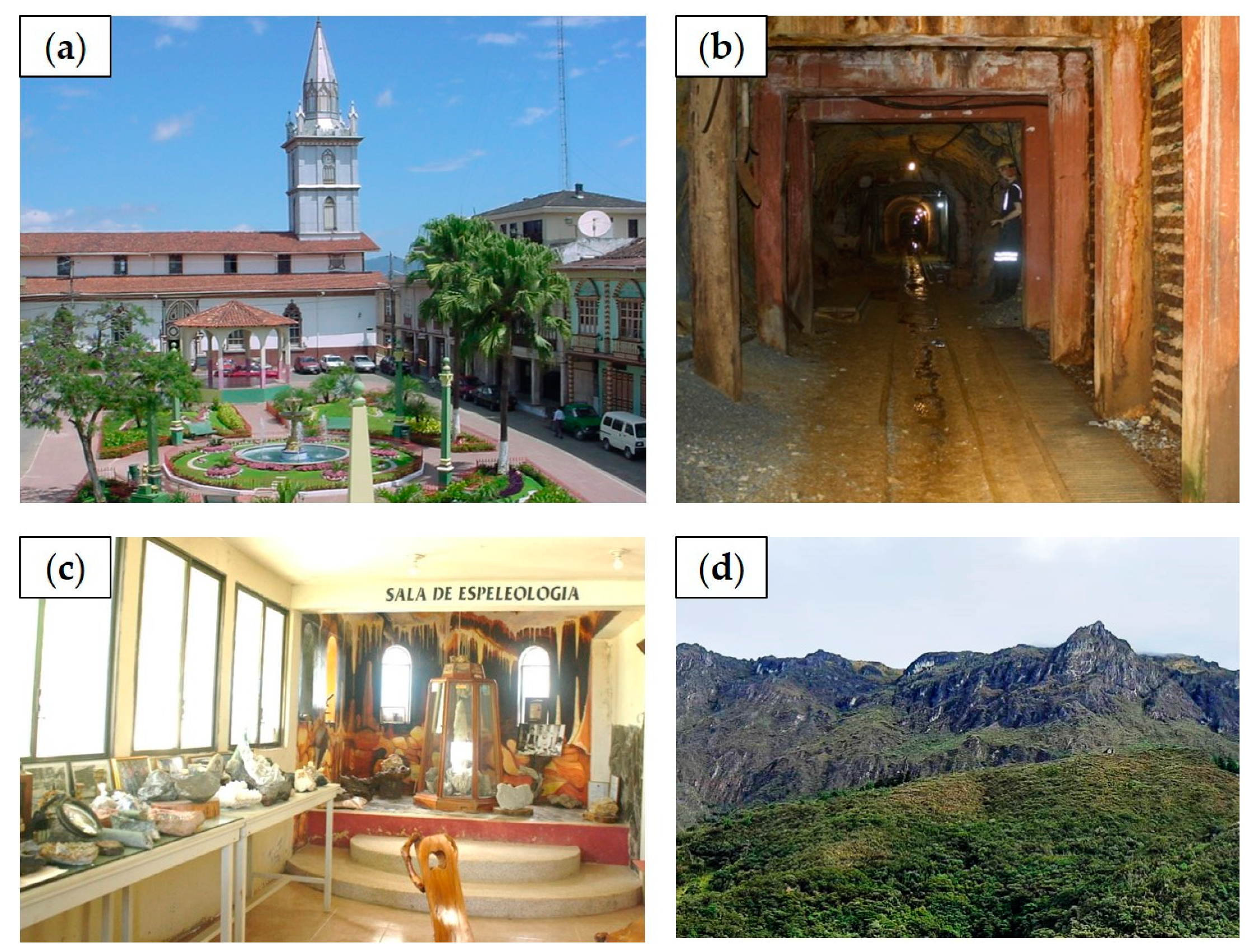
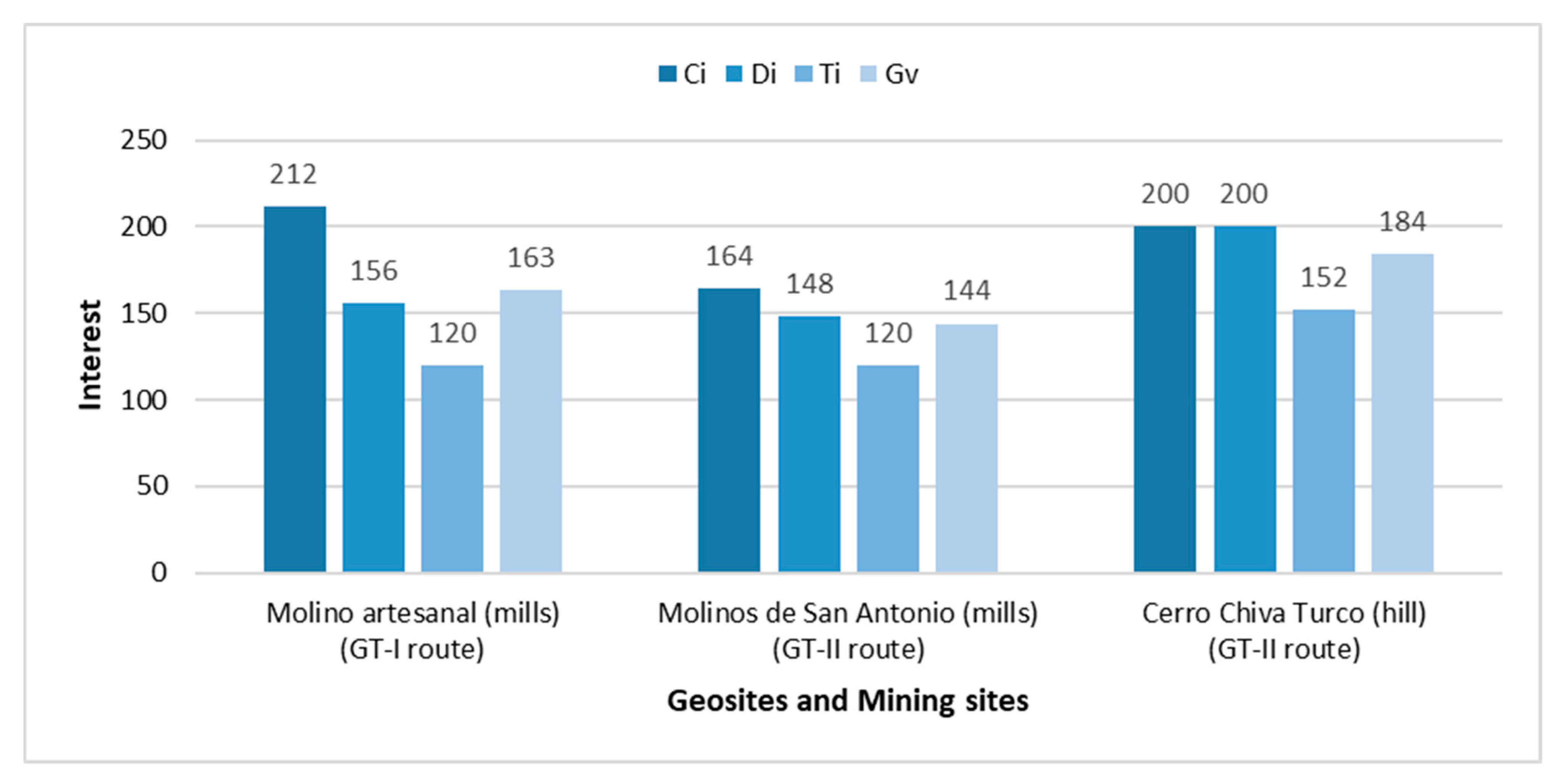
Table 2. Summary inventory of routes (two geotourists GT-I; GT-II and one geomining GM-III) proposed by other authors [34,60,61]. * Geosites/mining sites.
RoutesSitesSite Type/InterestLocation
GT-I
(Figure S1 in the Supplementary Material)
  • Monumento al minero (monument)
MiningPortovelo
2.
Museo Magner Turner (museum) *
Mining
3.
Casa minera (old house of managers) *
Mining
4.
Molino artesanal (mills) *
Mining
5.
Iglesia de Salvias (church)
ArchitecturalZaruma
6.
Cascada El Molino (waterfall) *
Geological
7.
Petroglifos de Salvias (petroglyphs)
Archaeological
8.
Museo de Zaruma (museum) *
Mining
9.
Centro de Zaruma (historic downtown)
Architectural
10.
Iglesia Virgen del Carmen (church)
Architectural
11.
Cerro El Calvario (hill) *
Geological
GT-II(Figure S2 in the Supplementary Material)
  • Iglesia Virgen del Carmen (church)
ArchitecturalZaruma
2.
Museo de Zaruma (museum) *
Mining
3.
Centro de Zaruma (historic downtown)
Architectural
4.
Cerro El Calvario (hill) *
Geological
5.
Cerro Zaruma Urcu (hill) *
Geological
6.
Mina El Sexmo (mine) *
Geological
7.
Urbanización Sur (thematic park)
Variable
8.
Iglesia de Roma (church)
Architectural
9.
Laguna de Chinchilla (lagoon) *
Geological
10.
Cerro de Arcos (hill) *
Geological
11.
Cascada Ortega (waterfall) *
Geological
12.
Molinos de San Antonio (mills) *
Geological
13.
Iglesia de Salvias (church)
Architectural
14.
Petroglifos de Salvias (petroglyphs)
Archaeological
15.
Petroglifos de Salvias II (petroglyphs)
Archaeological
16.
Cascada Chaca-Capac (waterfall) *
Geological
17.
Cerro Chiva Turco (hill) *
Geological
18.
Iglesia Güizhagüiña (church)
Architectural
GM-III(Figure S3 in the Supplementary Material)
  • Mina El Sexmo (mine) *
MiningZaruma
2.
Cerro Zaruma Urcu (hill) *
Geological
3.
Museo Magner Turner (museum) *
MiningPortovelo
4.
Fuente Aguas Calientes (natural spring) *
Geological
5.
Río Salvias (river) *
GeologicalZaruma
6.
Cascada Ortega (waterfall) *
Geological
Table 3. Fundamental criteria considered for the access of its geosites and mining sites of the studied routes.
RouteLength (Km)Degree of DifficultyAddressees Level of SafetyAccessibility
GT-I37.06LowIndividual tourists and organized groupsHighMain order roads
GT-II113.32HighIndividual tourists and organized groupsHighMain and secondary order roads and pedestrian paths.
GM-III63.59MediumIndividual tourists and organized groupsHighMain and secondary order roads and pedestrian paths.
Table 4. Analysis and SWOT matrix of the routes studied and proposed.
Internal AspectsStrengthsWeaknesses
External Aspects S1. The proposed route covers possible geosites and mining sites of historical, mining, natural and cultural relevance.
S2. Recreational and educational activities related to geosciences.
S3. Low-cost tour with tourist guides included.
S4. Zaruma and Portovelo are national heritages of Ecuador. In addition, Zaruma was declared a magical town of Ecuador.
W1. Lack of conservation policies for potential geosites and mining sites.
W2. The logistics are unfavourable on the primary and secondary roads of the route.
W3. The entire route must be done by vehicle due to the distance from the sites.
W4. Restricted access in mining interest sites because they are private property such as processing plants and lack of security protocols in others.
OpportunitiesStrategies: Strengths + OpportunitiesStrategies: Weaknesses + Opportunities
O1. The creation of a geopark that offers already designed mining georoutes.
O2. Increase in the economy of the cantons due to social enterprises.
O3. It is strengthening the development of alternative tourism “geotourism”.
O4. Use of mining geosites as dissemination of the importance of conservation of geological-mining heritage.
S1.O1. Identification of new possible geosites that promote the creation of a Geopark.
S2.O2.O3. Promote new forms of tourism, such as geological-mining parks, tourist mines and eco-museums to sustain communities.
S3.O3.O4. Promote educational and at the same time recreational tourism, through geosites and mining sites where the importance of conserving the geological-mining heritage of a community is evident.
W1.O4. Establish an immediate plan for the conservation of geosites, to be recognized as part of the cantons’ geological-mining heritage for the recovery of the mining landscape.
W2.O3. Recondition the road network, to strengthen tourism development for visitors.
O1.O4. Recreation of mining areas through good post-mining management for the practice of clean energy in the Geopark project.
ThreatsStrategies: Strengths + ThreatsStrategies: Weaknesses + Threats
T1. There is deterioration due to weathering effects in natural geosites.
T2. Illegal mining practice in the sector.
T3. The spread of COVID-19 and its impact on geotourism.
S1.T1.T2. Work together with responsible entities to protect sites (private or public) with great geotourism value.W1.T1. Set natural-type sites as a geological-mining heritage to be included in a protection project for them.
Publisher’s Note: MDPI stays neutral with regard to jurisdictional claims in published maps and institutional affiliations.

