A Balance Interface Design and Instant Image-based Traffic Assistant Agent Based on GPS and Linked Open Data Technology

Abstract
1. Introduction
2. Literature Review and Development Technologies
3. Proposed System Architecture
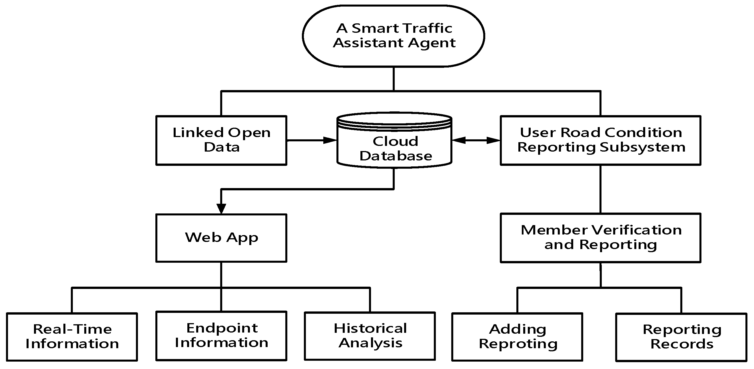
3.1. Overall System Architecture
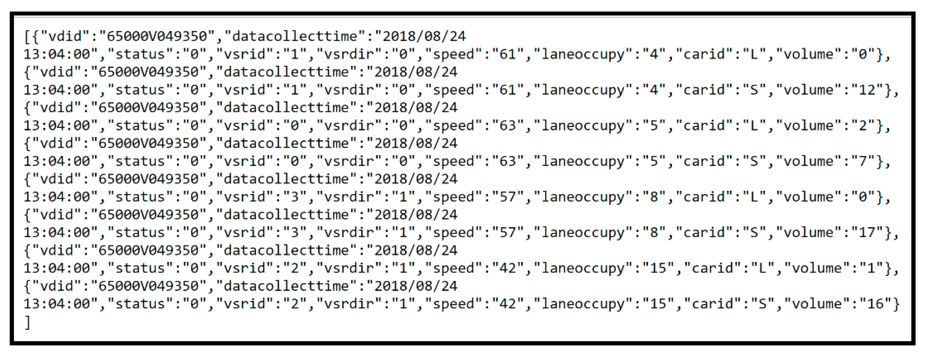
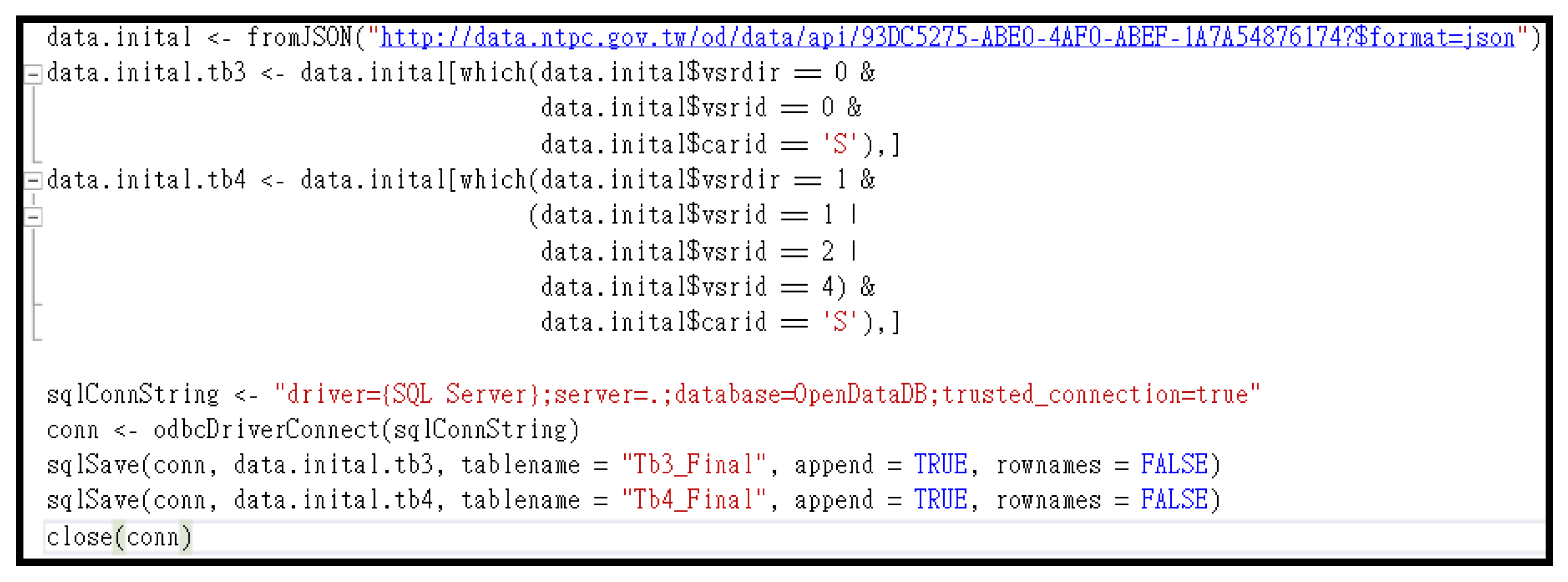
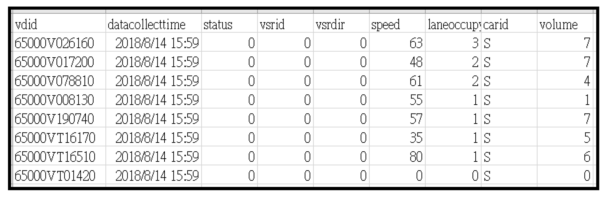
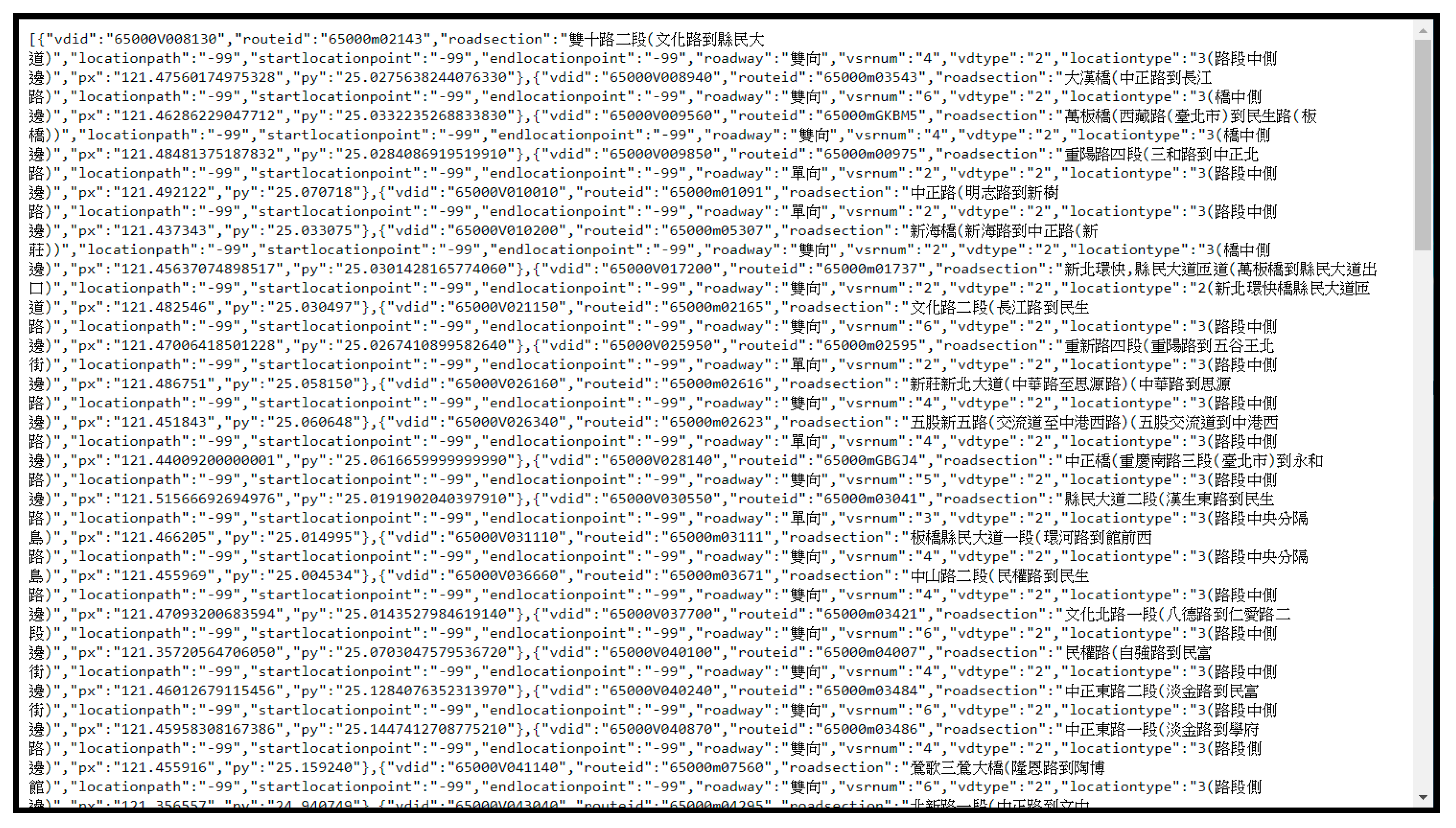
3.2. LOD
- vdid: endpoint number;
- datacollecttime: collection time;
- status: endpoint status;
- vsrid: road number;
- vsrdir: road direction;
- speed: detect the current speed;
- carid: detect the types;
- volume: detect the number of vehicles.
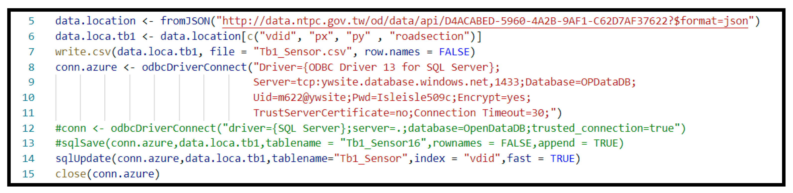
3.3. Establishment of Cloud Server and Corresponding Databases
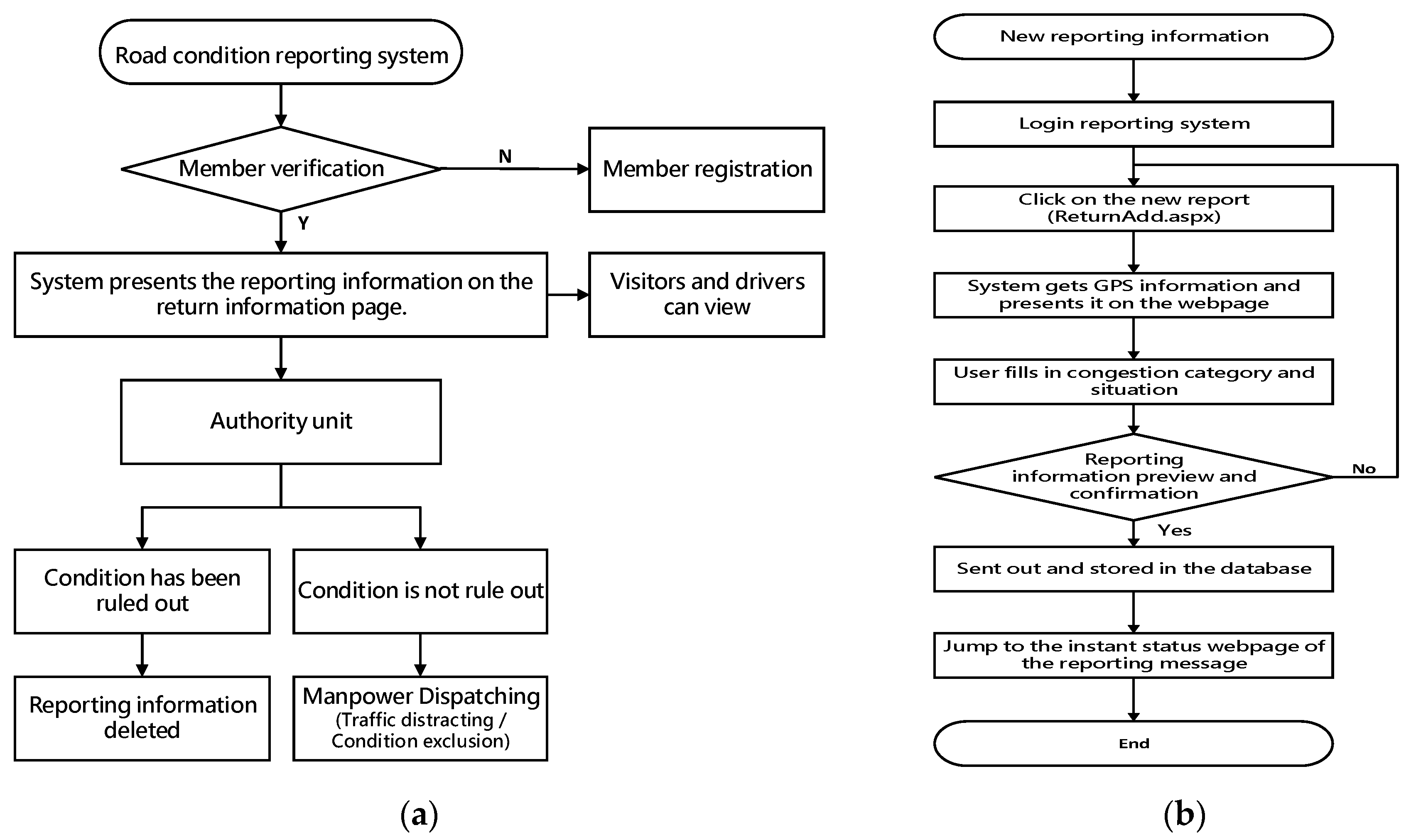
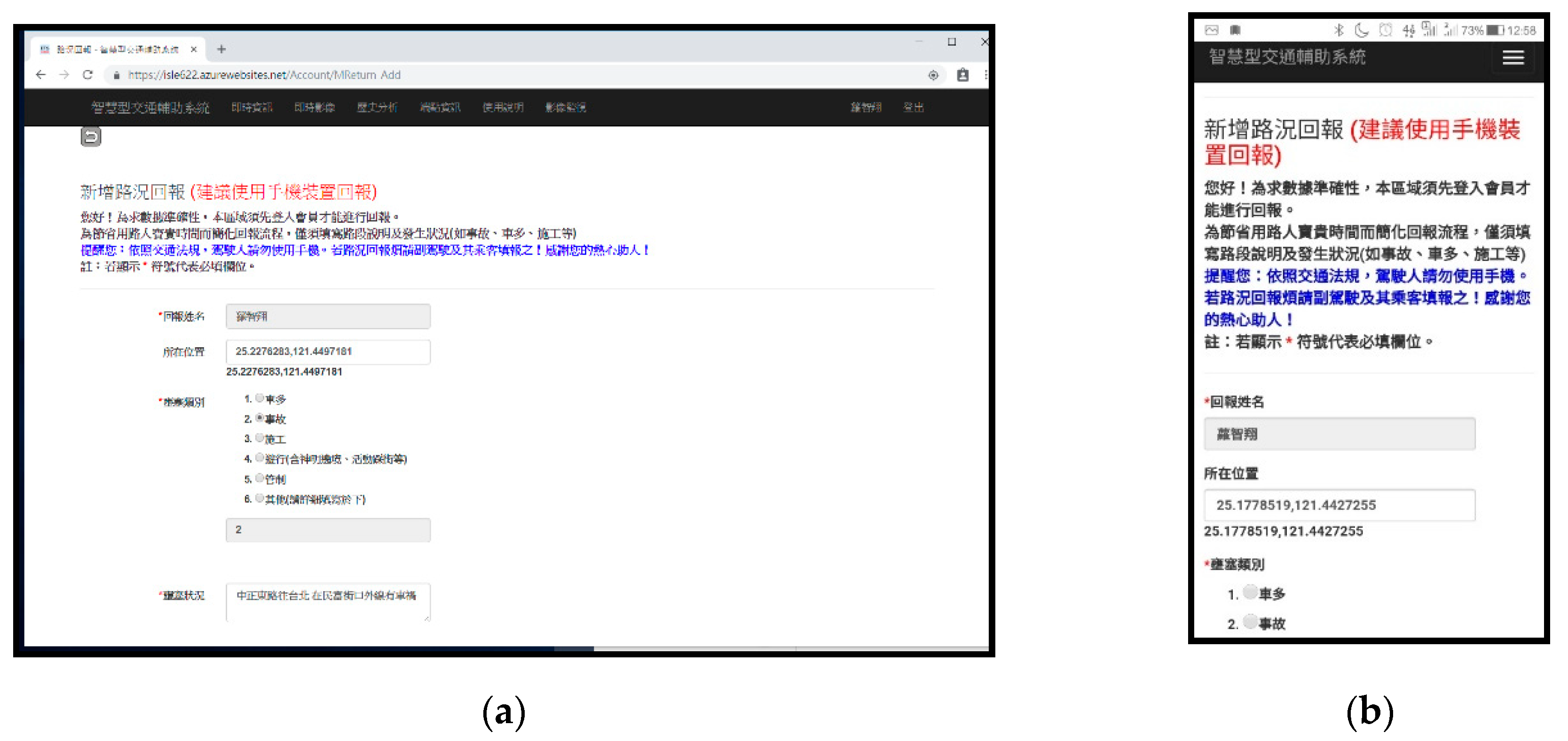
3.4. User Reporting Mechanism on Road Conditions
4. System Presentation and Efficiency Analysis
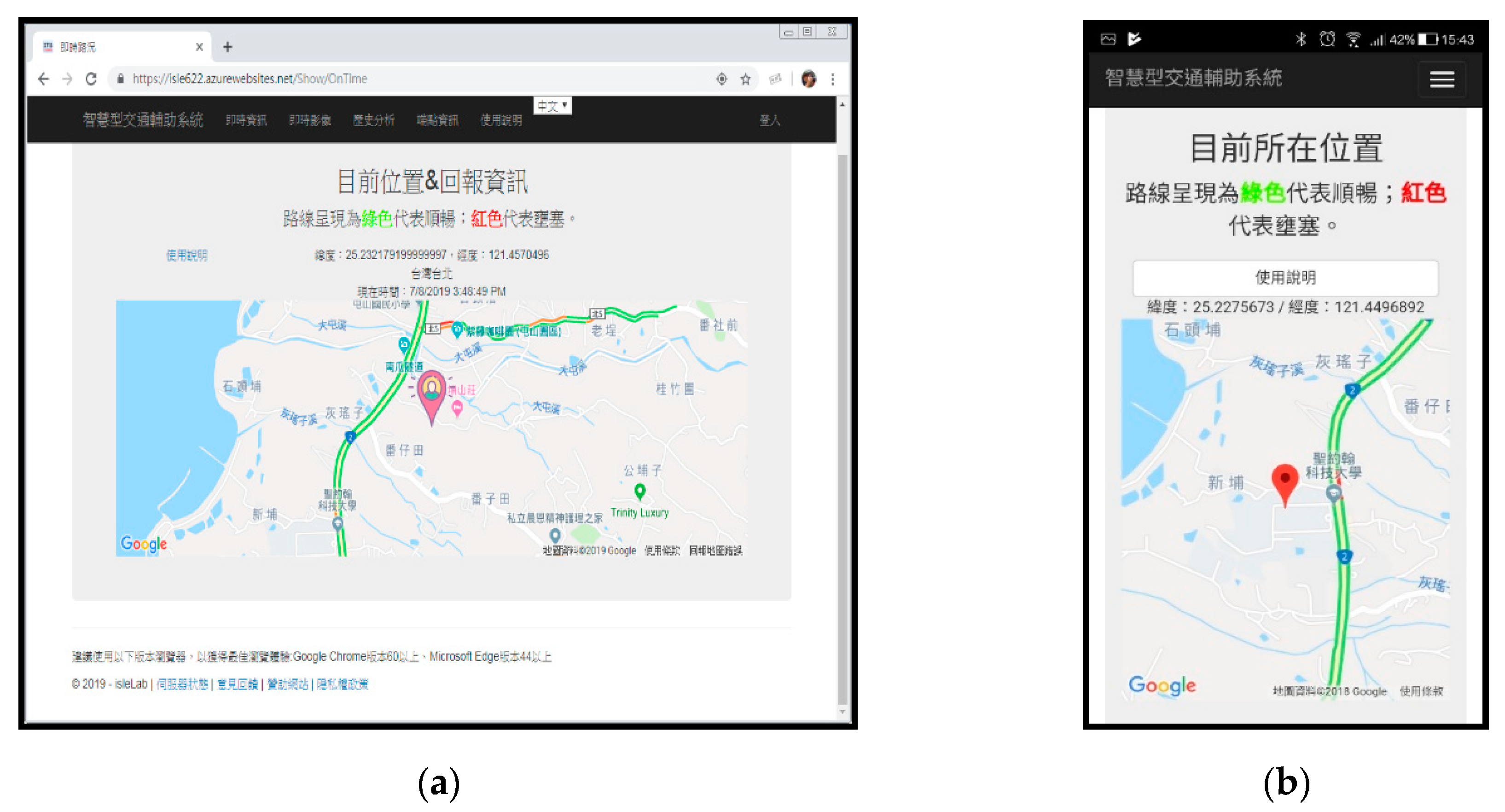
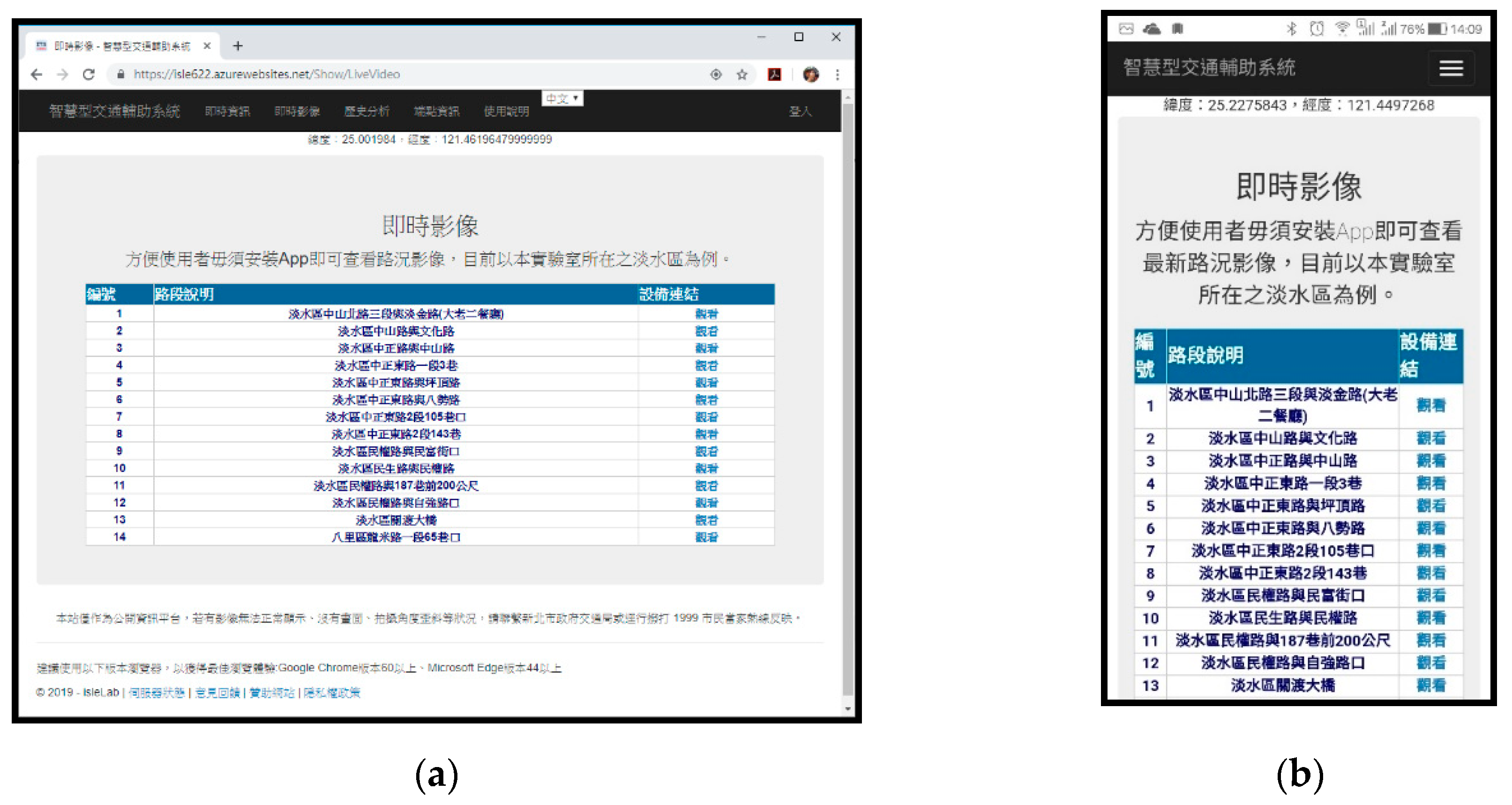
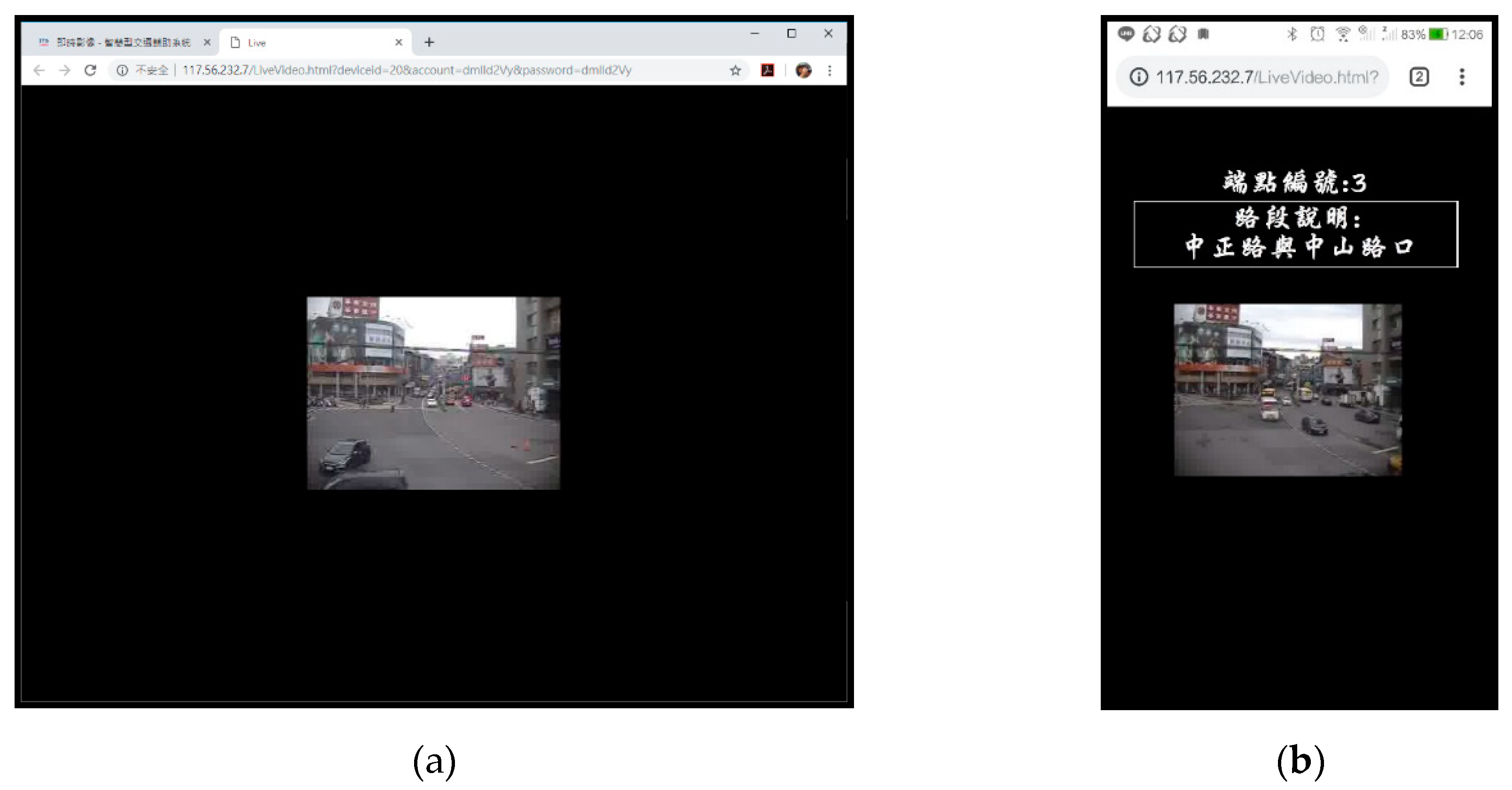
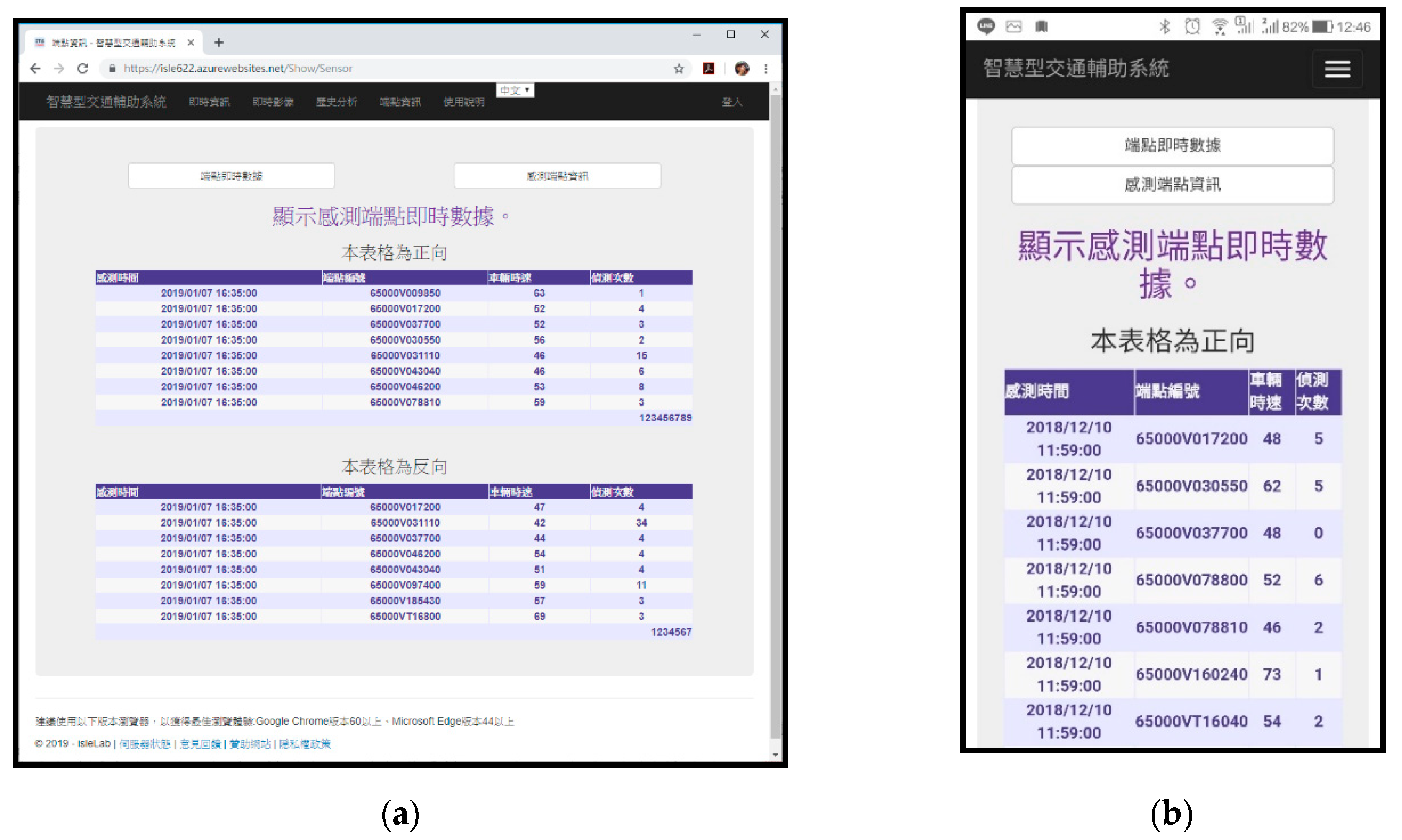
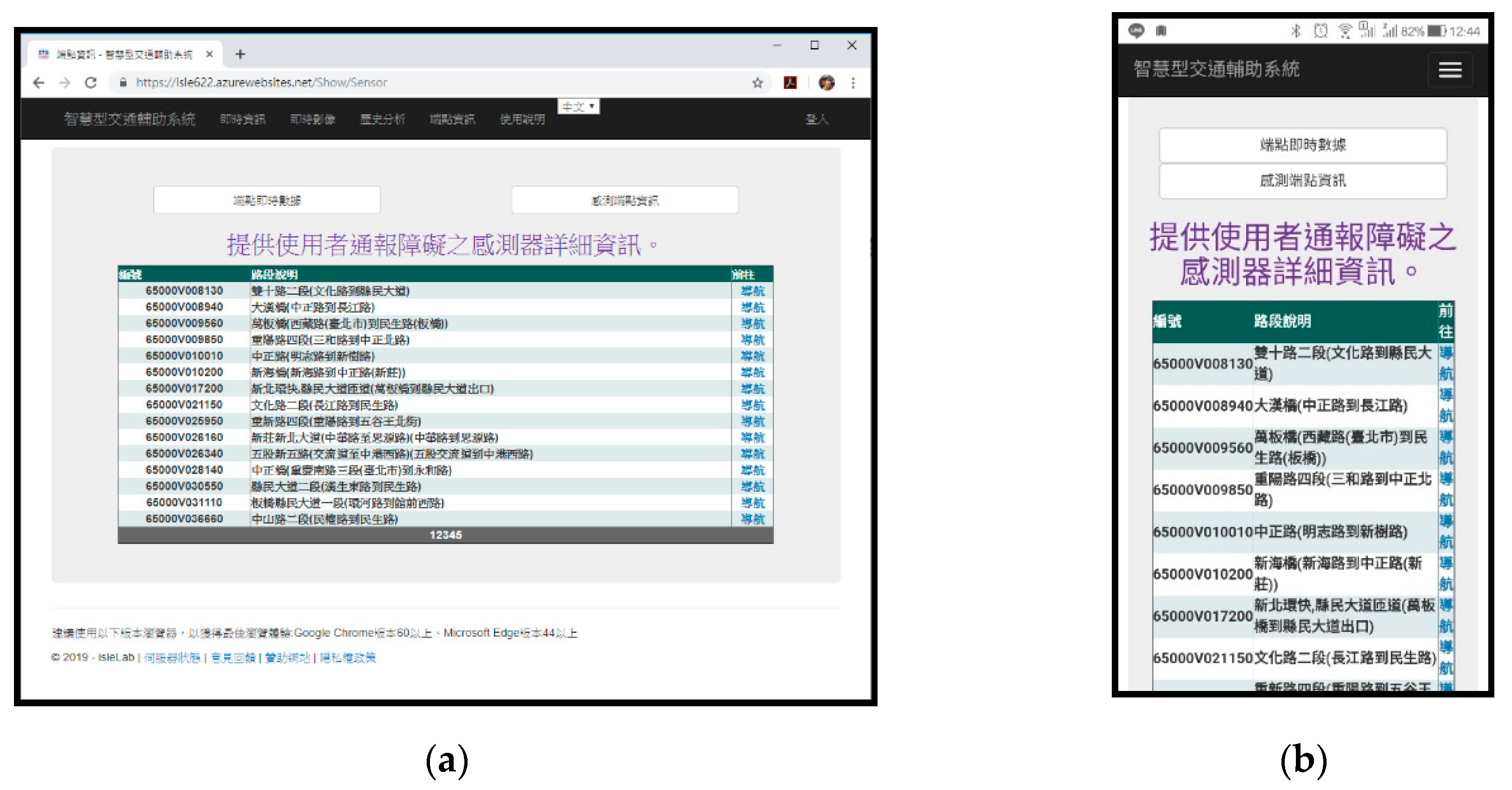
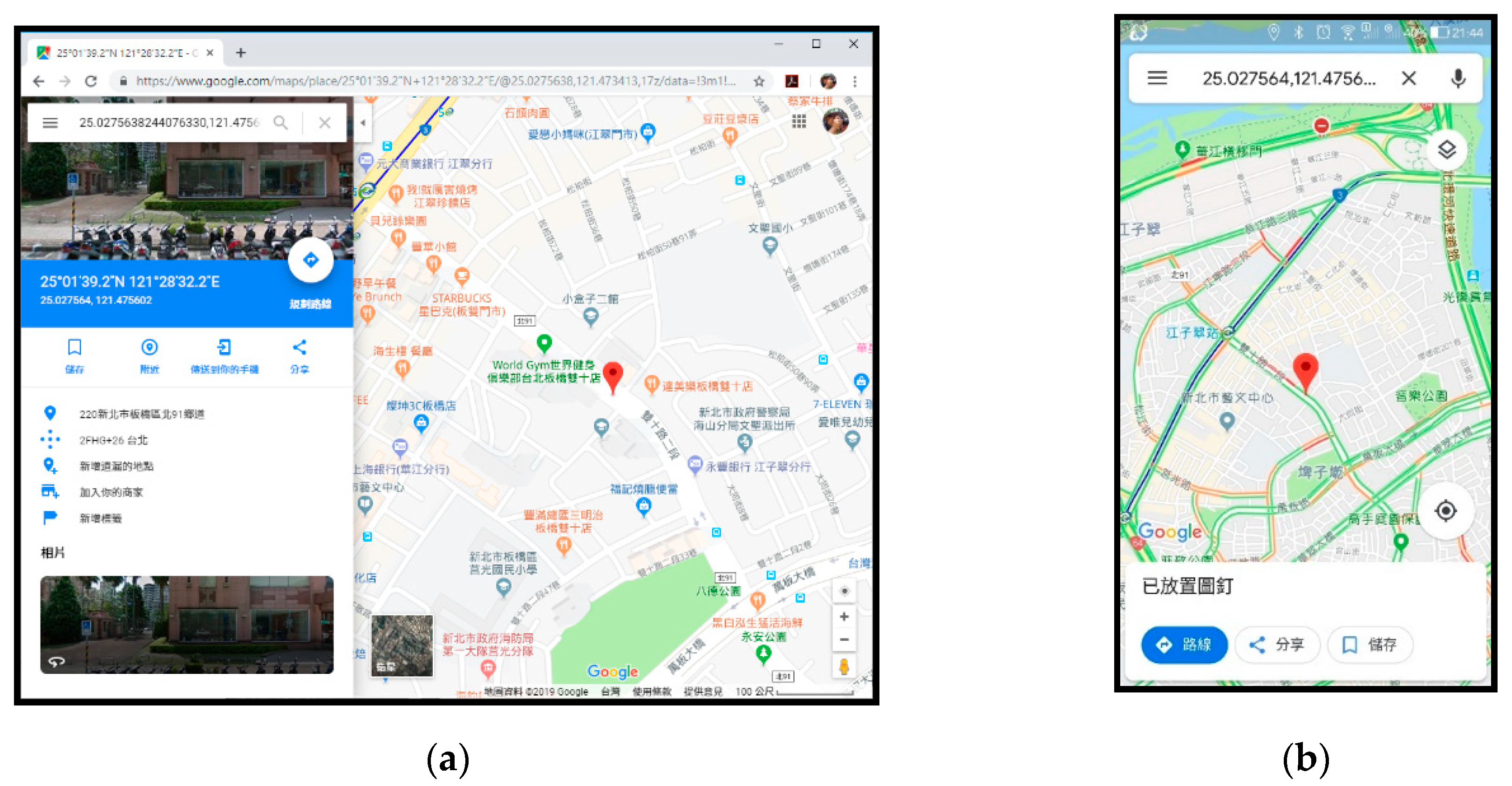
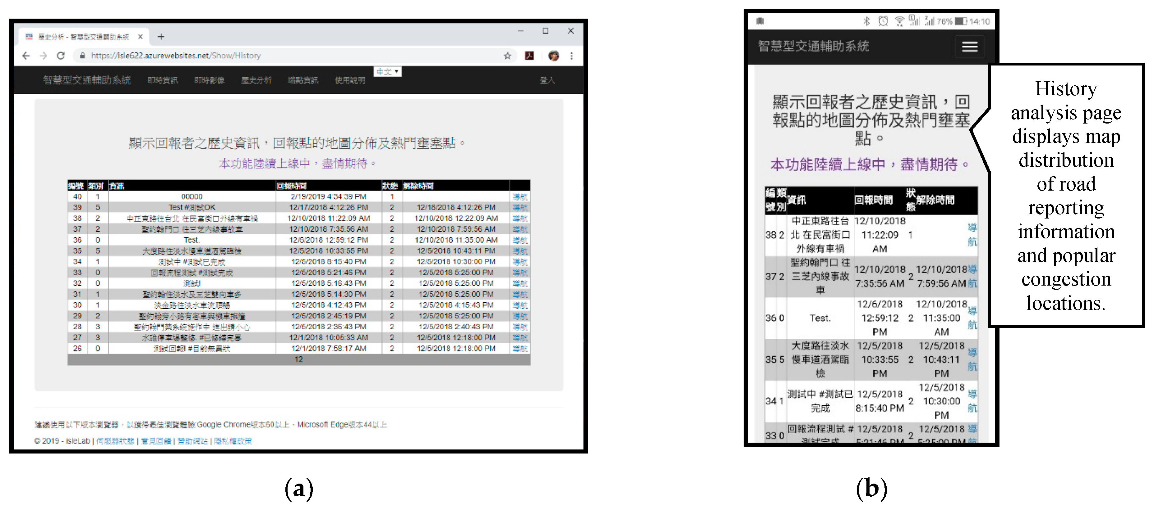
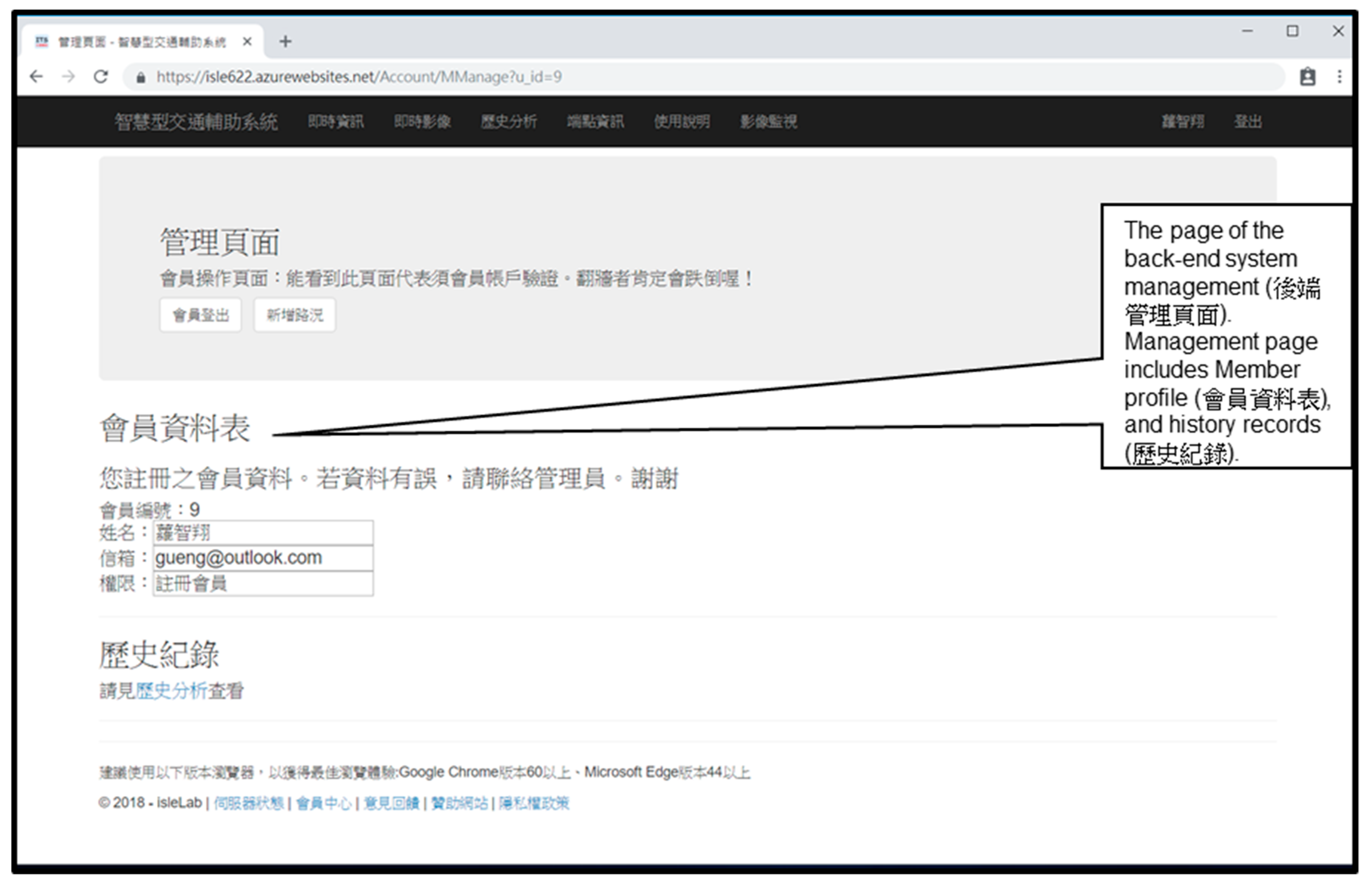
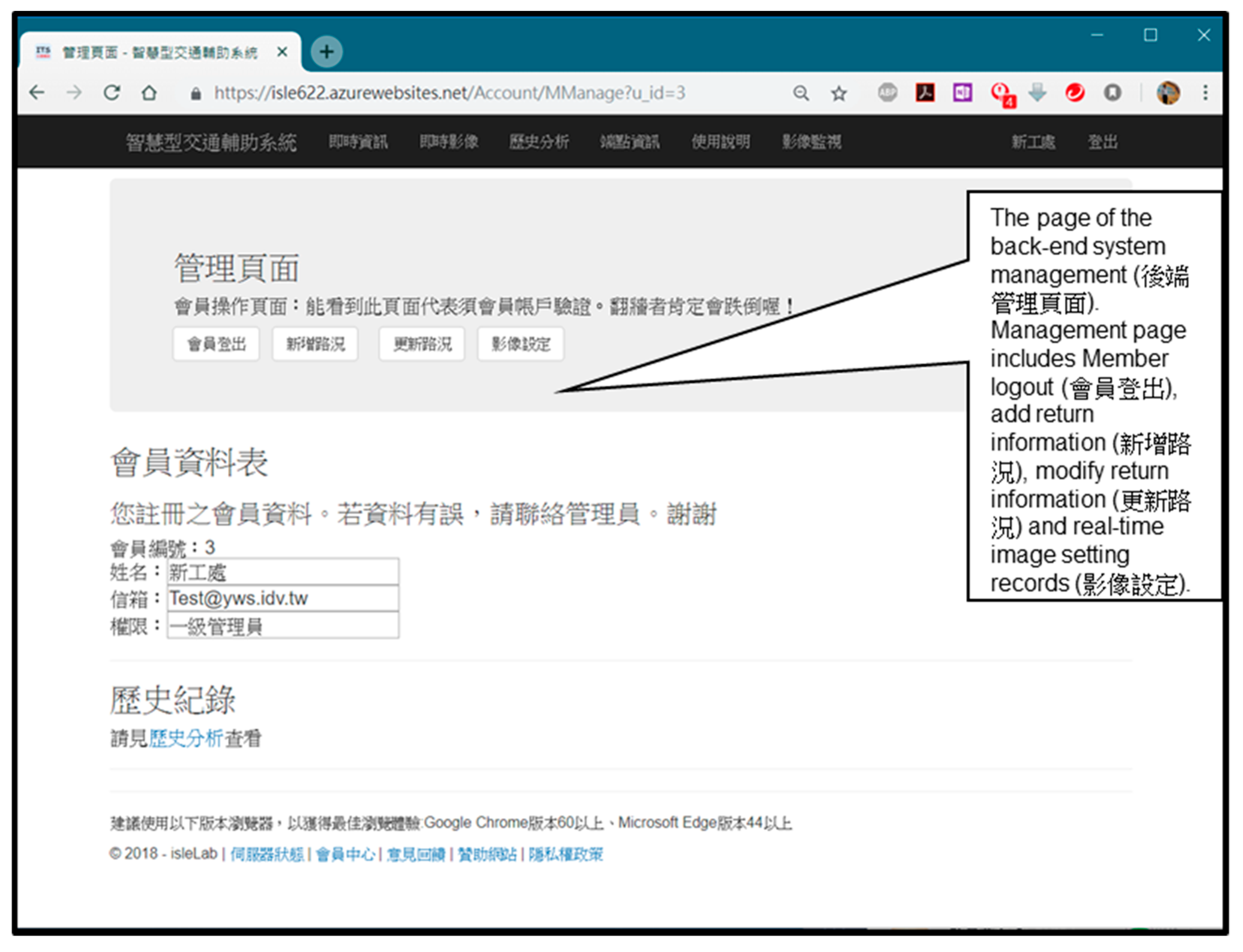
4.1. System Presentation
4.2. Performance Analysis
5. Conclusions and Discussions
- At present, the time for reporting road conditions is modified manually. In the future, a new system can be added to automatically judge the subsequent elimination time or cooperate with relevant government units, so that such units can carry out linked modification actions.
- Future studies can strengthen the introduction of the data analysis function, and present periodic analysis charts to facilitate exploration, planning, and overall review of traffic flows before being updated by cities in the future;
- Future studies can add an automatic reporting function for endpoint maintenance, where users can report sensor endpoint failures to relevant units;
- Multiple accounts (e.g., LINE login, Google login, etc.) can be authorized to save users’ login time before reporting road conditions.
- As mentioned above, Taiwan is narrow and crowded with people and cars. Depending on the navigation system, it is prone to the dilemma of avoiding road section “A” and entering the congested road section “B”. Therefore, the introduction of the proposed system is unique; however, Taiwan (including its capital city, Taipei) is an international tourist destination, and the interface version of future applications should adopt a multilingual model. In addition, future studies could explore how combining the proposed system with international traffic databases, such as a NoSQL database approach for processing traffic-related big data [56] and a real approach on open data and databases in analysis of traffic accidents [57]. Finally, further research can target the setting up of traffic information-related urban development strategies, data privacy rights, and urban data plans (e.g., four data-driven algorithms extracting useful information from high resolution traffic data [58], providing another level of automation in processing mechanisms and deserve more attention.
Author Contributions
Funding
Acknowledgments
Conflicts of Interest
References
- Sodano, D. Mobile Taiwan: A Look at a Highly Mobile Market. 2016. Available online: https://www.emarketer.com/Article/Mobile-Taiwan-Look-Highly-Mobile-Market/1014877 (accessed on 11 July 2019).
- National Development Council, Taiwan. Investigation Report on Individual and Household Digital Opportunity in 2018. Available online: https://ws.ndc.gov.tw/Download.ashx?u=LzAwMS9hZG1pbmlzdHJhdG9yLzEwL2NrZmlsZS81NzQyMWI3YS0xMjhmLTRmMzAtYTY0ZC04MzdiYTkzNmRkZDUucGRm&n=MTA35bm05YCL5Lq65a625oi25pW45L2N5qmf5pyD6Kq%2f5p%2bl5aCx5ZGKLnBkZg%3d%3d&icon=.pdf (accessed on 26 March 2019).
- He, W.Z. Taichung City Government Transcends Data Framework and Discovers Hidden Emotions to Make Traffic Management No Longer a Problem. 2017. Available online: https://www.ithome.com.tw/news/117280 (accessed on 11 July 2019).
- Ministry of the Interior Police Department, Taiwan. Traffic Accident Main Data Inquiry. 2018. Available online: http://stat.motc.gov.tw/mocdb/stmain.jsp?sys=100&funid=b3303 (accessed on 8 April 2018).
- Works Bureau of New Construction Office of the Taipei Municipal Government, Taiwan. Taipei City Road Management Center Promotes Road Construction Management Innovation Measures have Achieved Remarkable Results. 2018. Available online: https://nco.gov.taipei/News_Content.aspx?n=BB8CF6F431E10630&s=6F5661BD113EBD54 (accessed on 8 April 2018).
- New Taipei City Tourism Bureau, Taiwan. Annual Report of Tourism Bureau in 2017; New Taipei City Government: Taiwan, China, 2017. Available online: http://cdn.tour-ntpc.com/site/a3be84a9-7283-40a3-b4c7-758bf39c7828/Content/Upload/ContentPageFile/d4aebfd7-72ea-40d8-b87e-40c7e277e524.pdf (accessed on 26 March 2019).
- Su, W.B. The Number of Monthly Active Users in Line has Grown to 19 Million, and the Service Data has been Revealed! 2018. Available online: https://www.ithome.com.tw/news/121717 (accessed on 10 March 2018).
- Taiwan Ministry of Communications, China. Self-Use Passenger Car Usage Survey. 2019. Available online: http://ipgod.nchc.org.tw/dataset/315000000h-000004 (accessed on 24 November 2019).
- Taiwan Tourism Bureau, Ministry of Communications, China. Survey of Taiwanese Tourists in 2018. Available online: https://admin.taiwan.net.tw/FileUploadCategoryListC003340.aspx?CategoryID=7b8dffa9-3b9c-4b18-bf05-0ab402789d59&appname=FileUploadCategoryListC003340 (accessed on 24 November 2019).
- National Police Agency, Taiwan Ministry of Interior, China. Interior Information Open Platform: Historical Traffic Accident Information. 2019. Available online: https://data.moi.gov.tw/MoiOD/Data/DataDetail.aspx?oid=67781E29-8AAD-46A9-A2C8-C3F339592C27 (accessed on 24 November 2019).
- Flynn, D.B.; Gilmore, M.M.; Sudderth, E.A. Estimating Traffic Crash Counts Using Crowdsourced Data: Pilot Analysis of 2017 Waze Data and Police Accident Reports in Maryland; Technical Report: DOT-VNTSC-BTS-19-01; Bureau of Transportation Statistics: Washington, DC, USA, 2018.
- Chunghwa Telecom, Taiwan. Road Condition Quick Easy Pass Plus. 2018. Available online: https://play.google.com/store/apps/details?id=com.chttl.android.traffic.plus (accessed on 19 December 2018).
- Antyi, Taiwan. Real-Time Image of Traffic. 2018. Available online: https://play.google.com/store/apps/details?id=com.sy.twcctv (accessed on 19 October 2018).
- Lin, Z.Y. Police New. 2018. Available online: https://play.google.com/store/apps/details?id=tw.myself.oceanlin.newsbroadcast (accessed on 19 December 2018).
- New Taipei City Government, Taiwan. New Taipei City Instant Traffic Information Network. 2018. Available online: http://atis.ntpc.gov.tw/ (accessed on 9 November 2018).
- Cai, Y.H. Development of an Omni-Restaurant Information Consultation & Sharing Agent System with GPS & Linked Open Data Technologies. Master’s Thesis, Department of Information and Communication Engineering, St. John’s University, New Taipei City, Taiwan, 2015. [Google Scholar]
- Wang, Y.C. Automatic News Classification Using Machine Learning and Linked Open Data. Master’s Thesis, Department of Information Management, National University of Kaohsiung, Kaohsiung, Taiwan, 2018. [Google Scholar]
- Yan, Y.H. Building a Prototyping Platform of Open Government Linked Data. Master’s Thesis, Institute of Information Management, Chung Yuan Christian University, Taoyuan, Taiwan, 2018. [Google Scholar]
- Yu, C.Y. Research on Linked Open Data Applications Using Dynamic Context Data Analysis. Master’s Thesis, Department of Computer Science and Information Engineering, National Taiwan Normal University, Taipei, Taiwan, 2016. [Google Scholar]
- Albert, M.P.; Ashkan, A.; Christophe, G.; Stefan, S. CEDAR: The Dutch historical censuses as Linked Open Data. Semant. Web 2017, 8, 297–310. [Google Scholar]
- Alobaidi, M.; Mahmood, K.; Sabra, S. Semantic Enrichment for Local Search Engine using Linked Open Data. In Proceedings of the 25th International Conference Companion on World Wide Web, Montreal, QC, Canada, 11–15 April 2016; pp. 631–634. [Google Scholar]
- Selvam, S.; Balakrishnan, R.; Ramakrishnan, B. Social Event Detection-A Systematic Approach using Ontology and Linked Open Data with Significance to Semantic Links. Int. Arab J. Inf. Technol. 2018, 15, 729–738. [Google Scholar]
- Pourhomayoun, M.; Wang, H.; Vahedi, M.; Mazari, M.; Smith, J.; Owens, H.; Chernicoff, W. Real-Time Big Data Analytics for Traffic Monitoring and Management for Pedestrian and Cyclist Safety. In Proceedings of the Fifth International Conference on Big Data, Small Data, Linked Data and Open Data, Valencia, Spain, 24–28 March 2019; p. 33. [Google Scholar]
- Juan, Y.C. Analysis of Spatio-temporal Data of Office Workers Based on GPS Signals Collected from Mobile Device. Master’s Thesis, Department of Computer Science and Information Engineering, Feng Chia University, Taichung, Taiwan, 2018. [Google Scholar]
- Liou, G.T. A Multi-Epoch Algorithm for GPS/BDS Single Frequency Precise Point Positioning. Master’s Thesis, Institute of Applied Mechanics, National Taiwan University, Taipei, Taiwan, 2016. [Google Scholar]
- Tu, T.Y. Method of Monitoring and Locating Pets by GPS and BLE. Master’s Thesis, Institute of Electrical Engineering and Computer Science Master’s In-service Program, National Taipei University of Technology, Taipei, Taiwan, 2016. [Google Scholar]
- Fridman, L.; Weber, S.; Greenstadt, R.; Kam, M. Active Authentication on Mobile Devices via Stylometry, Application Usage, Web Browsing, and GPS Location. IEEE Syst. J. 2017, 11, 513–521. [Google Scholar] [CrossRef]
- Ta, N.; Zhao, Y.; Chai, Y. Built environment, peak hours and route choice efficiency: An investigation of commuting efficiency using GPS data. J. Transp. Geogr. 2016, 57, 161–170. [Google Scholar] [CrossRef]
- Aliprantis, J.; Kalatha, E.; Konstantakis, M.; Michalakis, K.; Caridakis, G. Linked Open Data as Universal Markers for Mobile Augmented Reality Applications in Cultural Heritage. Digit. Cult. Herit. Lect. Notes Comput. Sci. 2018, 10605, 79–90. [Google Scholar]
- Khaghani, F.; Rahimi-Golkhandan, A.; Jazizadeh, F.; Garvin, M.J. Urban Transportation System Resilience and Diversity Coupling Using Large-scale Taxicab GPS Data. In Proceedings of the 6th ACM International Conference on Systems for Energy-Efficient Buildings, Cities, and Transportation, New York, NY, USA, 13–14 November 2019; pp. 165–168. [Google Scholar]
- Bellavista, P.; Kupper, A.; Helal, S. Location-based services: Back to the Future. IEEE Pervasive Comput. 2008, 7, 85–89. [Google Scholar] [CrossRef]
- Syu, Y.C. The Framework of Location Based Service Using IoT Subscription Agreement—Taxi Service in Taoyuan Area as a Case. Master’s Thesis, Department of Computer Science and Information Engineering, Yuan Ze University, Taoyuan, Taiwan, 2018. [Google Scholar]
- Chou, C.C. The Study of Driving Safety Enhancement based on IoT and LBS. Master’s Thesis, Department of Information Communication, Chinese Culture University, Taipei, Taiwan, 2017. [Google Scholar]
- Sun, G.; Liao, D.; Li, H.; Yu, H.; Chang, V. L2P2: A location-label based approach for privacy preserving in LBS. Future Gener. Comput. Syst. 2017, 74, 375–384. [Google Scholar] [CrossRef]
- Wang, Y.; Xu, D.; Li, F. Providing Location-Aware Location Privacy Protection for Mobile Location-Based Services. Tsinghua Sci. Technol. 2016, 21, 243–259. [Google Scholar] [CrossRef]
- Ukrit, M.F.; Venkatesh, B.; Suman, S. Location Based Services with Location Centric Profiles. Int. J. Electr. Comput. Eng. 2016, 6, 3001–3005. [Google Scholar]
- Lin, C.; Su, H.; Knoblock, C.A.; Chiang, Y.Y.; Duan, W.; Leyk, S.; Uhl, J.H. Building Linked Data from Historical Maps. In Proceedings of the Second Workshop on Enabling Open Semantic Science Co-Located with 17th International Semantic Web Conference, Monterey, CA, USA, 8–12 October 2018; pp. 59–67. [Google Scholar]
- Sansonetti, G.; Gasparetti, F.; Micarelli, A. Cross-Domain Recommendation for Enhancing Cultural Heritage Experience. In Proceedings of the 27th Conference on User Modeling, Adaptation and Personalization, New York, NY, USA, 9–12 June 2019; pp. 413–415. [Google Scholar]
- Microsoft. The Developer’s Guide to Azure. 2018. Available online: https://go.microsoft.com/fwlink/?LinkId=862819&clcid=0x409 (accessed on 20 December 2018).
- Wikipedia. Microsoft Azure. 2018. Available online: https://en.wikipedia.org/wiki/Microsoft_Azure (accessed on 20 December 2018).
- Liou, W.X. An Azure ACES System for Air Quality Index Deteriorating Real-Time Early Warning. Master’s Thesis, Department of Information Management, National Yunlin University of Science and Technology, Yunlin, Taiwan, 2018. [Google Scholar]
- Ho, Y.C. A Case Study on Machine Learning for Customer Relationship Management in Service Industry. Master’s Thesis, Department of Management Information Systems, National Chengchi University, Taipei, Taiwan, 2018. [Google Scholar]
- Lin, Y.Z. Implementation of an Access Control System by Using Raspberry PI and Cloud Face Recognition Services. Master’s Thesis, Department of M-Commerce and Multimedia Applications, Asia University, Taichung, Taiwan, 2017. [Google Scholar]
- Richard, H. Check Out This Interactive Map of Azure Platform Services. 2016. Available online: https://www.itprotoday.com/microsoft-azure/check-out-interactive-map-azure-platform-services (accessed on 24 November 2018).
- Diaz, F.; Freato, R. Azure Data Lake Store and Azure Data Lake Analytics. In Cloud Data Design, Orchestration, and Management Using Microsoft Azure; Apress: Berkeley, CA, USA, 2018; pp. 327–392. [Google Scholar]
- Färber, M. The Microsoft Academic Knowledge Graph: A Linked Data Source with 8 Billion Triples of Scholarly Data. In Proceedings of the 18th International Semantic Web Conference, Auckland, New Zealand, 26–30 October 2019; pp. 113–129. [Google Scholar]
- Chang, W.C. Integration of Google Map API and Evolutionary Algorithm for Route Planning in Road Flatness Inspection. Master’s Thesis, Department of Civil Engineering, National Chung Hsing University, Taichung, Taiwan, 2016. [Google Scholar]
- Wang, J.W. Using Google Maps in Ambulance Dispatch—A Case Study of the 119 Emergency System of the New Taipei City Fire Department. Master’s Thesis, Department of Computer Science, National Taipei University of Education, Taipei, Taiwan, 2018. [Google Scholar]
- Rahmi, A.; Piarsa, I.N.; Buana, P.W. FinDoctor-Interactive Android Clinic Geographical Information System Using Firebase and Google Maps API. Int. J. New Technol. Res. 2017, 3, 8–12. [Google Scholar]
- Xia, N.; Cheng, L.; Chen, S.; Wei, X.; Zong, W.; Li, M. Accessibility based on Gravity-Radiation model and Google Maps API: A case study in Australia. J. Transp. Geogr. 2018, 72, 178–190. [Google Scholar] [CrossRef]
- Tan, Z.; Hasegawa, S.; Beuran, R. Concept Map Building from Linked Open Data for Cybersecurity Awareness Training. In Proceedings of the Japanese Society for Artificial Intelligence Special Interest Group on Advanced Learning Science and Technology Workshop, Ishikawa, Japan, 14 July 2018; pp. 1–6. [Google Scholar]
- Nyo, M.T.H.; Hein, W.Z. Design and Construction of Navigation Based Auto Self-Driving Vehicle using Google Map API with GPS. Int. J. Trend Sci. Res. Dev. 2019, 3, 65–68. [Google Scholar]
- Wikipedia. Google Traffic. 2018. Available online: https://en.wikipedia.org/wiki/Google_Traffic (accessed on 21 December 2018).
- Ryan, B. Responsive Web Design vs. Mobile App Development. 2013. Available online: https://www.techrepublic.com/blog/web-designer/responsive-web-design-vs-mobile-app-development/ (accessed on 15 December 2018).
- Ha, J.S. A Human-machine Interface Evaluation Method Based on Balancing Principles. Procedia Eng. 2014, 69, 13–19. [Google Scholar] [CrossRef]
- Kaur, M.; Singh, S.; Aggarwal, N. Study of NoSQL Databases for Storing and Analyzing Traffic Data. In Proceedings of the 2nd International Conference on Communication, Computing and Networking, NITTTR, Chandigarh, India, 29–30 March 2018; pp. 577–587. [Google Scholar]
- Gladović, P.V.; Deretić, N.N. Open data and databases in analysis of traffic accidents in Belgrade. Tehnika 2018, 73, 247–253. [Google Scholar] [CrossRef]
- Amini, Z. Data-Driven Approaches for Robust Signal Plans in Urban Transportation Networks. Ph.D. Thesis, Engineering-Civil and Environmental Engineering, Graduate Division, University of California, Berkeley, CA, USA, 2018. [Google Scholar]


| No | System Name | System Picture | Advantages | Disadvantages |
|---|---|---|---|---|
| 1 | Road Condition Autotoll (capture time: December 19, 2018) |  | Provide comprehensive applications for national expressways, hot spot areas, roads to and from airports, important urban roads, and scenic spots. | GPS function is still not perfect; often unable to read location information. Lack of user reporting function in this study. |
| 2 | Real-Time Traffic Image (capture time: October 19, 2018) |  | Provide real-time image application program for road conditions in the counties and cities of Taiwan, which is practical. | Lack of user reporting function in this study. |
| 3 | Police Broadcast Real-Time Road Conditions (capture time: October 18, 2018) |  | The website display includes date, time, road section description, category, etc. At this stage, it is still necessary to report road condition information by telephone or retrieve relevant government data to present relevant traffic information. | Lack of user reporting function in this study. |
| 4 | New Taipei City Advanced Traveler Information System (capture time: December 24, 2018) |  | The website uses responsive web design technology and can view relevant information pages in an optimal size on an intelligent handheld device. | The user position cannot be automatically obtained, and only the longitude and latitude positions originally set by the map are presented. Furthermore, entering the website still needs to be checked manually. Lack of user reporting function in this study. |
| Parameter | Function Description |
|---|---|
| Coords.Latitude | Latitude |
| Coords.Longitude | Longitude |
| Accuracy | Accuracy (error range between detected position and actual position) |
| Maximum Age | Time to reacquire location information |
| Authority Items | Visitor | Registered Member | Administrator |
|---|---|---|---|
| View real-time information | ✓ | ✓ | ✓ |
| View live images | ✓ | ✓ | ✓ |
| View reporting information | ✓ | ✓ | ✓ |
| Add reporting information | ✘ | ✓ | ✓ |
| Modify reporting information | ✘ | ✘ | ✓ |
| Real-time image setting | ✘ | ✘ | ✓ |
| Membership management | ✘ | ✘ | ✓ |
| Administrative Rights Items | Public Works Unit | Police Unit | Back-end Management |
|---|---|---|---|
| Add reporting information | ✓ | ✓ | ✓ |
| Modify reporting information | ✓ | ✓ | ✓ |
| Real-time image setting | ✘ | ✓ | ✓ |
| Membership management | ✘ | ✘ | ✓ |
| Click | The Proposed System | Police Broadcast Real-Time Traffic | Road Conditions Autotoll | Real-Time Traffic Image: RoadCam | New Taipei City Advanced Traveler Information System |
|---|---|---|---|---|---|
| Open real-time information | 1 | 2 | 3 | 2 | 1 |
| Open real-time image | 1 | 2 | 3 | 2 | 2 |
| Open traffic report | 4 | 6 | X | X | X |
| Road conditions reporting content | 1 | 2 | X | X | X |
| Real-time weather information | X | 1 | X | 2 | 2 |
| Personalized subscription information | X | X | 1 | X | X |
| Disaster prevention monitoring information | X | X | X | 2 | 3 |
| Other information links | 1 | 1 | 1 | 1 | 1 |
| Average information acquisition | 1.6 | 2.3 | 2 | 1.8 | 1.8 |
| Comparison Items | Comparison Items | The proposed System | Police Broadcast Real-Time Traffic | Road Conditions Autotoll | Real-Time Traffic Image: RoadCam | New Taipei City Advanced Traveler Information System |
|---|---|---|---|---|---|---|
| Positioning | Continuous positioning | ✓ | ✓ | ✓ | ✓ | ✓ |
| Outdoor positioning | ✓ | ✓ | ✓ | ✓ | ✓ | |
| Cross platform | Android | ✓ | ✓ | ✓ | ✓ | ✓ |
| iOS | ✓ | ✘ | ✓ | ✓ | ✓ | |
| Chrome/Safari | ✓ | ✓ | ✘ | ✘ | ✓ | |
| User experience | Easy to update | ✓ | ✓ | ✓ | ✓ | ✘ |
| Easy to operate | ✓ | ✓ | ✘ | ✘ | ✓ | |
| Graphical interface | ✓ | ✘ | ✓ | ✓ | ✓ |
| HMI Elements | Description | Design Preference | Informational Importance | Remarks |
|---|---|---|---|---|
| RTILL | Real-time information label | 5 | 0.204082 | Label in Text |
| ARTILT | A real-time image list | 3 | 0.265306 | List in Text |
| EAILL | Endpoint analysis information label | 3 | 0.265306 | Label in Text |
| RTTLL | Real-time reporting label | 3 | 0.265306 | Label in Text |
| HMI Elements | DIR | Description | BI |
|---|---|---|---|
| RTILL | 1.228055 | Needs to improve a little bit | 0.012534 |
| ARTILT | 0.939958 | Needs to improve a little bit | |
| EAILL | 0.944658 | Needs to improve a little bit | |
| RTTLL | 0.939958 | Needs to improve a little bit |
© 2019 by the authors. Licensee MDPI, Basel, Switzerland. This article is an open access article distributed under the terms and conditions of the Creative Commons Attribution (CC BY) license (http://creativecommons.org/licenses/by/4.0/).
Share and Cite
Chen, F.-H.; Yang, S.-Y. A Balance Interface Design and Instant Image-based Traffic Assistant Agent Based on GPS and Linked Open Data Technology. Symmetry 2020, 12, 1. https://doi.org/10.3390/sym12010001
Chen F-H, Yang S-Y. A Balance Interface Design and Instant Image-based Traffic Assistant Agent Based on GPS and Linked Open Data Technology. Symmetry. 2020; 12(1):1. https://doi.org/10.3390/sym12010001
Chicago/Turabian StyleChen, Fu-Hsien, and Sheng-Yuan Yang. 2020. "A Balance Interface Design and Instant Image-based Traffic Assistant Agent Based on GPS and Linked Open Data Technology" Symmetry 12, no. 1: 1. https://doi.org/10.3390/sym12010001
APA StyleChen, F.-H., & Yang, S.-Y. (2020). A Balance Interface Design and Instant Image-based Traffic Assistant Agent Based on GPS and Linked Open Data Technology. Symmetry, 12(1), 1. https://doi.org/10.3390/sym12010001