1. Introduction
Urban fragmentation and socio-spatial inequality are commonly analysed through residential segregation, spatial distance, and the uneven distribution of urban resources. These approaches have been central to understanding how social differences become inscribed in urban space and how unequal access to housing, services, infrastructures and opportunities shapes urban life [
1,
2,
3,
4]. However, fragmentation is not only a matter of where different social groups live, nor can it be fully understood through the formal distribution of resources across the city. It is also manifested and may be reproduced through the ways in which urban space is used, selected, avoided, represented and incorporated into everyday life.
This issue is particularly relevant in medium-sized cities. Unlike large metropolitan areas, where social differentiation is often associated with long distances, infrastructural discontinuities or large-scale suburbanisation, medium-sized cities tend to be more compact. In Southern European contexts, socially contrasting neighbourhoods may be located close to one another, sharing the same formal urban structure and, in some cases, the same centralities and services. Yet physical proximity does not necessarily generate social integration, equal access or shared urban experience. Compact urban forms may conceal more subtle forms of fragmentation, organised through differentiated everyday practices, symbolic boundaries and unequal capacities to access and appropriate urban resources.
From this perspective, the fragmented city should not be understood solely as a set of separated residential areas or disconnected urban fragments. It must also be analysed as a field of unevenly practised accessibility. Conventional planning and governance frameworks generally estimate potential accessibility through proximity, service provision, infrastructure or connectivity. These indicators are necessary, but they do not capture whether different social groups effectively incorporate urban resources into their daily lives. Rather, triangulating GPS trajectories, interviews and mental maps adds evidence on whether urban resources are actually incorporated into daily routines and how patterns of use and non-use relate to reported purposes, constraints and representations. We refer to this complementary dimension as practised accessibility. It cannot be inferred from territorial reach alone: wider car-based mobility does not necessarily imply greater freedom, nor does concentrated mobility automatically indicate disadvantage.
This article examines how selective everyday spatial practices mediate access to places, activities and opportunities in a medium-sized city. It argues that these inequalities are manifested not only through residential location, but also through the stabilisation of differentiated spatial repertoires: the routines, routes, centralities, omissions and representations through which different groups construct their effective city. By focusing on daily mobility, activity spaces, lived boundaries and cognitive representations, the article contributes to debates on urban fragmentation, socio-spatial inequality and spatial governance.
The empirical analysis focuses on Lleida, a medium-sized city in inland Catalonia, Spain. Lleida provides a relevant analytical context because its relatively compact urban structure limits the explanatory role of large-scale distance and makes it possible to observe how structurally conditioned inequalities are manifested, experienced and potentially reproduced in the everyday organisation of urban life. The study compares two socially contrasting neighbourhoods: Ciutat Jardí, a low-density, high-income residential area, and La Mariola, a neighbourhood historically associated with social vulnerability and territorial stigma. Their spatial proximity within the same urban system makes the comparison especially useful for analysing how fragmentation may persist where physical distance is limited.
The article draws on a mixed-methods design combining in-depth interviews, mental maps and GPS tracking. This approach makes it possible to analyse the city as practised, perceived and represented. GPS trajectories provide evidence of daily mobility, activity spaces and territorial reach; interviews reveal the meanings, constraints and decisions associated with everyday movements; and mental maps help identify how residents cognitively delimit, classify and hierarchise urban space. The aim is not to produce statistically generalisable measurements, nor to establish the casual weight of specific practices, but to examine how structurally conditioned inequalities are manifested, experienced and potentially reproduced in everyday spatial practices.
Previous work derived from the same research project, based on the same 35 interviews and GPS records from a sub-sample of 16 participants analysed lived fragmentation and everyday trajectories in Lleida, focusing on mobility patterns and unequal forms of dwelling [
5]. This article does not treat this shared corpus as a new empirical dataset. Instead, it undertakes a distinct analytical extension by incorporating the mental maps produced during the interviews, and by recoding the interview material through new categories of spatial non-use, cognitive delimitation and symbolic classification. It therefore asks how spatial practices, cognitive representations and symbolic classifications jointly structure the effective experience of the city, and what their relationship reveals about practised accessibility in a compact medium-sized city. The article’s contribution lies in the systematic integration of the city as practised, narrated and represented, connecting everyday urban inequality with broader debates on spatial governance and urban planning.
The findings suggest contrasting configurations of everyday mobility, centralities, spatial selection and cognitive representation among participants from the two neighbourhoods (
Table 1). Taken together, these patterns indicate that partial overlapping around consolidated urban centralities does not necessarily translate into interaction, recognition or a shared urban experience.
The article therefore contributes to debates on urban inequality by conceptualising unequal everyday geographies as both manifestations of structurally conditioned inequalities and mechanisms through which these may be reproduced. These geographies are not defined only by where people live, but by how they move, what they select, what they avoid, what they know and what they consider legitimate or relevant within the city. In doing so, the paper shows that urban fragmentation in medium-sized cities may operate less through visible separation than through the uneven incorporation of urban space into everyday life.
The argument has relevant implications for urban policy and spatial governance. If fragmentation is manifested and may be reproduced through everyday practices, planning interventions cannot rely exclusively on potential accessibility, formal proximity or the spatial distribution of services. They should also address practised accessibility: the temporal, modal, cognitive and symbolic conditions that enable different social groups to access, combine and appropriate urban resources in practice.
The article is organised as follows.
Section 2 develops the conceptual framework, linking residential segregation, everyday mobility, symbolic boundaries and cognitive representations.
Section 3 presents the case study, data and mixed-methods approach.
Section 4 analyses differentiated mobility patterns, centralities, avoidance and cognitive representations.
Section 5 discusses the findings in relation to activity-based segregation, partial urban experiences, medium-sized cities and practised accessibility. The conclusion summarises the main contributions and outlines implications for more equitable urban planning and spatial governance.
2. Everyday Spatial Practices, Practised Accessibility and Urban Inequality
2.1. Urban Inequality Beyond Residential Segregation
Urban inequality has traditionally been examined through residential segregation and the uneven spatial distribution of populations and resources. Classic approaches have shown how socioeconomic differentiation is inscribed in the urban fabric through patterns of spatial separation, functional specialisation and unequal access to infrastructures and services [
1,
2]. From this perspective, the city appears as a structured field of opportunities and constraints shaped by broader processes of economic restructuring and social stratification.
However, an exclusive focus on residential patterns risks overlooking how inequality is experienced and reproduced in everyday life. Spatial proximity does not necessarily translate into social interaction, integration or equal access to urban resources [
6,
7]. This is particularly relevant in medium-sized cities, where relatively compact urban forms and the proximity of socially contrasting neighbourhoods may conceal persistent forms of socio-spatial differentiation [
8,
9,
10].
In such medium-sized urban contexts, fragmentation does not necessarily take the form of large-scale spatial separation or clearly defined physical barriers. Instead, it may emerge through more subtle processes embedded in everyday practices, where the effective use of urban space becomes unevenly distributed. Understanding urban inequality therefore requires moving beyond static residential patterns and examining how different social groups access, navigate, select and appropriate the city in their daily lives.
This shift is also relevant for debates on spatial governance and urban planning. Conventional approaches often evaluate accessibility through proximity, infrastructure, service provision or connectivity. These dimensions are necessary, but they do not fully capture whether urban resources are effectively incorporated into everyday life. A facility may be spatially close and formally accessible while remaining outside the routines, perceived possibilities or legitimate spaces of certain groups. For this reason, the analysis of urban inequality requires attention not only to potential accessibility, but also to practised accessibility, i.e., the ways in which access is actually produced, constrained or normalised through everyday spatial practices.
2.2. Everyday Mobility, Activity Spaces and Spatial Selection
A growing body of research has emphasised the importance of everyday mobility and activity spaces in shaping access to the city. Rather than being defined solely by place of residence, individuals’ spatial experiences are structured through the locations they routinely visit, the routes they follow and the temporal rhythms that organise their daily activities [
11,
12,
13].
From this perspective, mobility is not simply a functional movement between locations, but a socially situated practice that reflects unequal access to time, resources and opportunities [
14,
15]. Differences in employment conditions, care responsibilities, economic resources and transport accessibility shape the extent and diversity of individual activity spaces [
16,
17].
These inequalities translate into differentiated spatial repertoires. For some groups, the city can be experienced as an open and flexible environment, where mobility includes elective and exploratory dimensions. For others, everyday movements tend to be more constrained, repetitive and centred on functionally necessary locations. As a result, the effective city experienced by different groups may vary significantly, even within the same urban area.
This dynamic can be understood as a process of spatial selection. Certain places become embedded in everyday routines as sites of consumption, sociability, care, work or leisure, while others remain marginal, avoided or absent from daily trajectories. Selective practices therefore contribute to the production of uneven urban geographies that are not always visible in residential data but are fundamental for understanding how inequality operates in practice.
Importantly, differentiated spatial repertoires do not only reflect pre-existing inequalities; they actively contribute to their reproduction. By structuring access to social networks, services, centralities and opportunities, everyday mobility patterns shape the effective possibilities of urban life. In this sense, activity spaces can be read as one empirical expression of practised accessibility: they show not only where resources are located, but which parts of the city are used, combined and made relevant in everyday life.
2.3. Symbolic Boundaries, Stigma and Territorial Hierarchies
Spatial practices are not only shaped by material constraints, but also by symbolic and cognitive frameworks that classify and hierarchise urban space. As Lamont and Molnár [
18] argue, symbolic boundaries function as systems of social classification that distinguish between “us” and “others”, often becoming spatially anchored in particular neighbourhoods and urban areas.
In urban contexts, these processes are closely linked to territorial reputations and forms of spatial stigma. As Wacquant [
19] has shown, certain neighbourhoods may become marked by negative symbolic meanings that affect both external perceptions and the lived experiences of their residents. These representations are not merely descriptive but have performative effects: they shape patterns of avoidance, influence mobility decisions and condition access to opportunities [
20]. Recent research has deepened this understanding by showing how residents actively negotiate stigma through everyday spatial practices and boundary work [
21,
22,
23].
At the same time, urban divisions are sustained through normalised social distances that do not necessarily rely on physical barriers. As Caldeira [
24] suggests, some spaces are taken for granted as legitimate and do not require justification, while others are subject to scrutiny, explanation or avoidance. This asymmetry reflects unequal capacities to define what is considered normal, desirable or appropriate within the urban context.
These symbolic hierarchies interact with everyday practices, guiding processes of selection and exclusion that contribute to the reproduction of urban inequality. The use of space is therefore not only a matter of material access, but also of legitimacy, recognition and belonging. From the perspective of practised accessibility, symbolic boundaries matter because they shape which places are perceived as available, familiar, desirable or irrelevant, even when they are physically close.
2.4. Cognitive Maps and the Production of Differentiated Urban Experiences
Urban experience is also structured through cognitive representations that organise how individuals perceive, interpret and navigate the city. Since Lynch [
25], research has shown that individuals do not inhabit the city as a continuous and homogeneous whole, but as selective configurations composed of meaningful elements such as nodes, paths, edges and landmarks.
These cognitive maps are closely intertwined with everyday practices. As Kwan [
11] highlights, mobility and situated experience shape the extent and structure of spatial knowledge. Frequently visited places acquire cognitive centrality, while areas that are rarely accessed or actively avoided tend to be marginalised or excluded from mental representations [
26]. Research using cognitive maps and interviews has shown that residents’ subjective neighbourhood boundaries may reproduce broader territorial divisions and inequalities [
27,
28].
In contexts of urban inequality, these representations may diverge significantly across social groups [
29]. Differences in mobility patterns and spatial repertoires influence the breadth and complexity of the known city, leading to uneven territorial familiarity and recognition. As a result, a formally shared urban space may become fragmented into distinct experiential worlds, where certain areas are central and meaningful for some groups but peripheral, irrelevant or invisible for others.
In this sense, cognitive maps do not simply reflect urban space; they actively structure how it is experienced. They contribute to the consolidation of differentiated everyday geographies by defining which places are known, named, valued, avoided or omitted. This has implications for urban planning, because the effective accessibility of urban resources depends not only on their location, but also on whether they are cognitively incorporated into everyday urban experience.
2.5. Integrating Practice, Representation and Practised Accessibility
Bringing these strands together, this paper understands urban inequality as the structurally conditioned unequal distribution of resources, opportunities, capacities and recognition. Although rooted in broader socioeconomic and institutional arrangements, urban inequality is experienced and may be reproduced through the interaction between spatial practices, cognitive representations and symbolic hierarchies. Differentiated everyday geographies are therefore conceptualised as both manifestations of structural inequality and mechanisms through which it may persist or be reinforced, rather than being solely determined by residential location.
This perspective enables a relational understanding of urban inequality, highlighting how socially differentiated urban geographies reflect structural inequalities while also being shaped through everyday practices. Even in contexts of spatial proximity, differences in mobility, spatial selection, territorial meaning and cognitive familiarity result in unequal access to urban resources, opportunities and recognition. The city may therefore be formally shared while being effectively experienced through distinct and only partially overlapping spatial repertoires.
The concept of unequal everyday geographies captures this relationship. It refers to the differentiated ways in which urban space becomes practised, known and made meaningful by different social groups. These geographies take shape through the interaction between unequal structural conditions and daily routes, selected centralities, avoided spaces, symbolic boundaries and cognitive representations. Within this configuration, activity-based segregation describes the spatial differentiation of routine activity spaces; symbolic boundaries refer to the cognitive and evaluative classification of urban areas; and partial urban experiences denote socially differentiated ways of practising, knowing and interpreting the same formally shared city. Practised accessibility refers more specifically to the temporal, modal, economic, cognitive and symbolic conditions under which urban resources and opportunities become effectively available in daily life.
This approach also provides a bridge between everyday urban inequality and spatial governance. If fragmentation is manifested and may be reproduced through the uneven incorporation of urban space into everyday life, then planning cannot rely only on potential accessibility, proximity or the spatial distribution of resources. It must also consider practised accessibility: the temporal, modal, cognitive and symbolic conditions through which different groups are able, or unable, to access, combine and appropriate urban resources in practice.
3. Case Study, Data and Methods
This article is based on a mixed-methods study of everyday spatial practices in Lleida, a medium-sized city in inland Catalonia, Spain. The empirical design combines in-depth interviews, mental maps and GPS tracking (PAJ GPS®, Windeck, Germany) in order to analyse how urban space is practised, perceived and represented by residents of two socially contrasting neighbourhoods. This combination makes it possible to examine not only where people live, but also how they move through the city, which places they use or avoid, and how they cognitively and symbolically organise urban space.
The research does not aim to measure the frequency or causal weight of specific behaviours, but to understand how everyday spatial practices and urban representations are constructed and experienced in daily life. The focus is therefore on the effective city: the set of places, routes, centralities, absences and boundaries that become incorporated into residents’ everyday spatial repertoires.
3.1. Study Area and Neighbourhoods
The study was conducted in Lleida, a medium-sized city located in western Catalonia, with 147,369 inhabitants and 54,543 households in 2025 (
Table 2). In this study, medium-sized cities are identified through a combined city-urban area criterion rather than municipal population alone. Following Andrés and Bellet [
30], medium-sized urban areas are defined as those articulated by one or more central cities with between 50,000 and 250,000 inhabitants and a total population not exceeding 400,000 across the urban area. Lleida has a relatively compact urban structure, in which socially contrasting neighbourhoods are located within short distances of one another and share the same broader urban system. This makes it a relevant setting for analysing how urban fragmentation may persist in contexts where large metropolitan distances or major infrastructural discontinuities are not the main explanatory factors. In such a context, socio-spatial differentiation can be examined through everyday practices of access, selection, avoidance and representation.
The analysis focuses on two neighbourhoods with contrasting socioeconomic profiles and different positions within the symbolic geography of the city: Ciutat Jardí and La Mariola (
Table 2). Their comparison allows us to explore differences not only in residential conditions, but also in everyday mobility, activity spaces, centralities, lived boundaries and representations of the city. These differences provide relevant contextual evidence of unequal economic resources, although neighbourhood-level indicators should not be interpreted as individual characteristics of all participants.
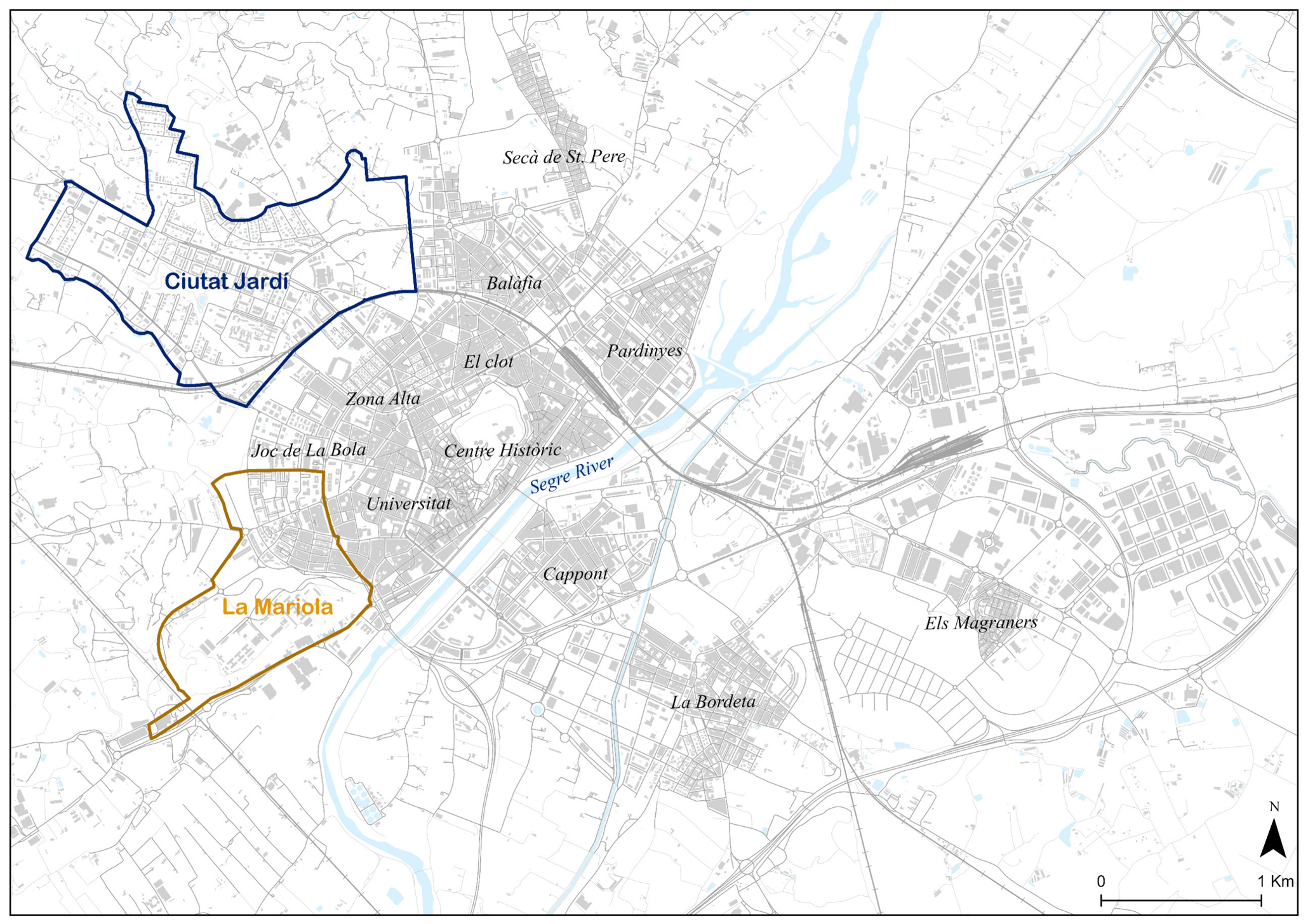
Ciutat Jardí, illustrated with the blue polygon in
Figure 1, is located in the north-western sector of Lleida. As
Table 2 shows, it is a low-density, high-income residential area, characterised by the predominance of single-family housing, relatively large plots, environmental quality and proximity to open and green spaces. Its urban development has been linked to a residential model based on tranquillity, comfort and socio-residential distinction within the municipal structure. In the local urban imaginary, Ciutat Jardí is generally associated with residential desirability, quality of life and social status. These characteristics make it a useful case for analysing how privilege is expressed not only through residential location, but also through elective mobility, selective centralities and the capacity to organise the city as a network of preferred destinations.
La Mariola, illustrated with the yellow polygon in
Figure 1, is located in the western part of Lleida, and has a very different urban trajectory. It is one of the areas where a significant part of the city’s publicly promoted housing built during Franco’s dictatorship and the second half of the twentieth century was concentrated. Its urban fabric is marked by polygonal housing estates and by the accumulation of public housing interventions, first promoted by state agencies and later by regional and local administrations. These interventions played a decisive role in shaping the neighbourhood’s morphology, its internal structure and its relationship with the rest of the city.
Unlike Ciutat Jardí, La Mariola has historically been associated with social vulnerability, public housing, urban marginalisation and territorial stigma. As
Table 2 shows, both neighbourhoods have significant differences regarding population and household income: Ciutat Jardí has a smaller population and higher income levels. However, La Mariola’s position in the city cannot be understood only through socioeconomic indicators: it must also be understood through the long-term production of symbolic boundaries and negative territorial representations. The neighbourhood has been repeatedly identified in local urban debates as an area requiring regeneration, particularly in relation to the physical condition of some housing estates, the quality of public space and the persistence of stigmatising images. This makes La Mariola especially relevant for analysing how urban inequality is lived through constrained mobility, localised routines, defensive narratives and more explicit awareness of urban hierarchies.
The contrast between the two neighbourhoods is therefore not reduced to income or urban morphology. It also concerns their different degrees of residential legitimacy, symbolic recognition, modal resources and everyday access to the city. Their relative proximity within the same medium-sized urban system allows the study to examine how fragmentation may be reproduced through differentiated spatial practices even when physical distance is limited.
3.2. Mixed-Methods Design and Data Collection
The empirical material comprises the same 35 interviews and GPS records from 16 participants used in Bellet Sanfeliu and Lasala Fortea [
5], together with mental maps produced during those interviews but not analysed or represented in the previous publication. This design was conceived to capture three interconnected dimensions of urban experience: the city as narrated, the city as represented, and the city as practised. Methodologically, this is a qualitative-dominant embedded mixed-methods design, implemented sequentially at participant level and integrated during analysis. Interviews and the accompanying mental-map exercise form the principal qualitative strand, while complementary GPS tracking began immediately afterwards for the selected sub-sample.
First, 35 semi-structured interviews were conducted with residents of Ciutat Jardí and La Mariola: 19 in Ciutat Jardí and 16 in La Mariola (
Table 3). The basic eligibility criterion was current residence in one of the two neighbourhoods. Participants were recruited through local social services and indirect personal referrals (friends of friends), while ensuring that no participant was directly acquainted with the researcher before the fieldwork. Purposive sampling sought gender diversity within eight predefined profiles combining life-course stage, household composition, dependency, caregiving responsibilities and support needs: older people living alone; older people living with a partner; adults in family households with dependants; adults in family households without dependants; single adults with dependants; young people dependent on the family household; young adults living independently or transitioning to independence; and adults with disabilities or support needs affecting their autonomy. Because these profiles served as recruitment criteria rather than as the final descriptive categories, they were consolidated for presentation in
Table 3 into four broader household types: “Empty nest”, “Single parent”, “Young families” and “Established families”, and cross-tabulated by gender and life-course group. Each interview lasted approximately one hour. In this qualitative comparative design, sample adequacy was grounded in the breadth of profiles covered and the depth of the interview material, rather than in the sample’s numerical proportion of the neighbourhood population. The study therefore does not seek to estimate the prevalence of the identified patterns or make statistically generalisable claims about either neighbourhood, but to develop an analytically grounded comparison of the mechanisms, meanings and spatial practices observed within an internally diverse purposive sample.
Second, a sub-sample of 16 participants, eight from each neighbourhood, took part in one week of GPS tracking, thereby covering both weekdays and weekend days. All tracking took place in Lleida during April and May. Concentrating data collection within the same spring period was intended to reduce seasonal climatic variability across participants and improve the comparability of the recorded mobility patterns. The GPS data were used to identify daily trajectories, activity spaces, route intensity and the territorial reach of everyday practices. The resulting spatial material made it possible to visualise the degree of concentration or dispersion of daily mobility, the location of recurrent centralities and the extent to which different parts of the city were incorporated into everyday routines.
The GPS component is treated as exploratory and complementary rather than statistically representative. Its purpose is not to produce a general mobility survey, but to provide spatial evidence that can be interpreted alongside interviews and mental maps. The resulting trajectories should therefore be interpreted as representing springtime everyday mobility rather than seasonal variation throughout the year. The value of the design lies in triangulation: interviews reveal meanings, constraints and justifications; mental maps show cognitive delimitations and symbolic hierarchies; and GPS trajectories make visible the spatial configuration of everyday practices.
3.3. Analytical Strategy, Ethics and Scope
The analysis followed an inductive thematic procedure. Interview transcripts were coded collaboratively by the research team using ATLAS.ti® (Version 26.1.2), with categories emerging through iterative reading and comparison. These categories were consolidated into four analytical dimensions corresponding to the structure of the results section: daily mobility and activity spaces; centralities and spatial selection; avoidance and lived boundaries; and cognitive representations of the city. After source-specific analysis, interview codes, mental maps and GPS patterns were integrated at participant and neighbourhood levels within each dimension.
Interview transcripts were analysed thematically in order to identify recurrent patterns in the way participants described their daily routines, selected destinations, avoided places and perceived different neighbourhoods. Particular attention was paid to the discursive differences between taken-for-granted non-use, explicit avoidance, perceived constraint and symbolic distancing. Mental maps were analysed in relation to the places and neighbourhoods mentioned, the boundaries drawn or described, and the positive or negative meanings attached to different parts of the city. GPS trajectories were processed to identify recurrent routes, territorial reach, spatial intensity and areas of overlap or non-overlap between participants from both neighbourhoods.
The analysis therefore combines spatial and interpretive procedures. It does not treat GPS data as neutral measurements of mobility, nor interviews as merely subjective accounts. Instead, both are read together as complementary ways of capturing practised accessibility: how different residents are able, or unable, to incorporate places, resources and centralities into everyday life.
The research followed ethical procedures appropriate for qualitative and geolocated data. The project was submitted for review to the Ethics Committee of the Universitat de Lleida and to the university’s Data Protection Unit, given the sensitivity of the information derived from interviews and geolocation records. Participants were informed about the objectives of the study and gave consent prior to participation. Interview material was anonymised using pseudonyms, and particular care was taken in the treatment of GPS data because of the sensitivity of daily routines and location records. Spatial information was cleaned, aggregated and represented in ways that avoided identifying individual participants or specific private locations.
The study is designed as an in-depth comparative analysis rather than as a statistically representative mobility survey. The GPS sub-sample is exploratory and is interpreted in combination with interview narratives and mental maps, allowing spatial patterns to be read alongside residents’ meanings, constraints and representations. The study does not calculate a conventional potential-accessibility indicator and therefore does not provide a direct metric comparison with practised accessibility, which is used here as a complementary interpretive perspective; such a comparison remains a task for future research. The participants’ current health status was not systematically recorded. The study therefore cannot assess their independent influence on mobility patterns, spatial familiarity or cognitive representations. Likewise, the focus on two contrasting neighbourhoods within a single medium-sized city is not intended to represent all urban contexts, but to identify mechanisms through which fragmentation is reproduced in everyday spatial practices. This intensive mixed-methods design provides a robust basis for analysing how, in a compact medium-sized city, urban inequality is produced not only through residential differentiation, but also through unequal activity spaces, selective centralities, avoidance and cognitive representations.
4. Results
The results show that urban fragmentation is produced through four interrelated dimensions: differentiated everyday mobility, the selective construction of centralities, patterns of avoidance and exclusion, and cognitive representations of the city. Taken together, these dimensions reveal how unequal urban experiences are structured through the differential use, interpretation and incorporation of urban space into everyday life. Rather than operating primarily through physical distance, fragmentation emerges through the stabilisation of distinct spatial repertoires that define which parts of the city become accessible, meaningful or absent for different groups.
4.1. Differentiated Everyday Mobility and Activity Spaces
The combined analysis of interviews and GPS tracking shows that urban inequality becomes visible in the spatial configuration of everyday trajectories. Beyond residential location, the data reveal systematic differences in territorial reach, intensity of use and the ways in which urban space becomes incorporated into everyday experience. The broad contrast in everyday mobility between the two neighbourhoods was identified in Bellet Sanfeliu and Lasala Fortea [
5], and is retained here as the spatial baseline for the integrated analysis that follows.
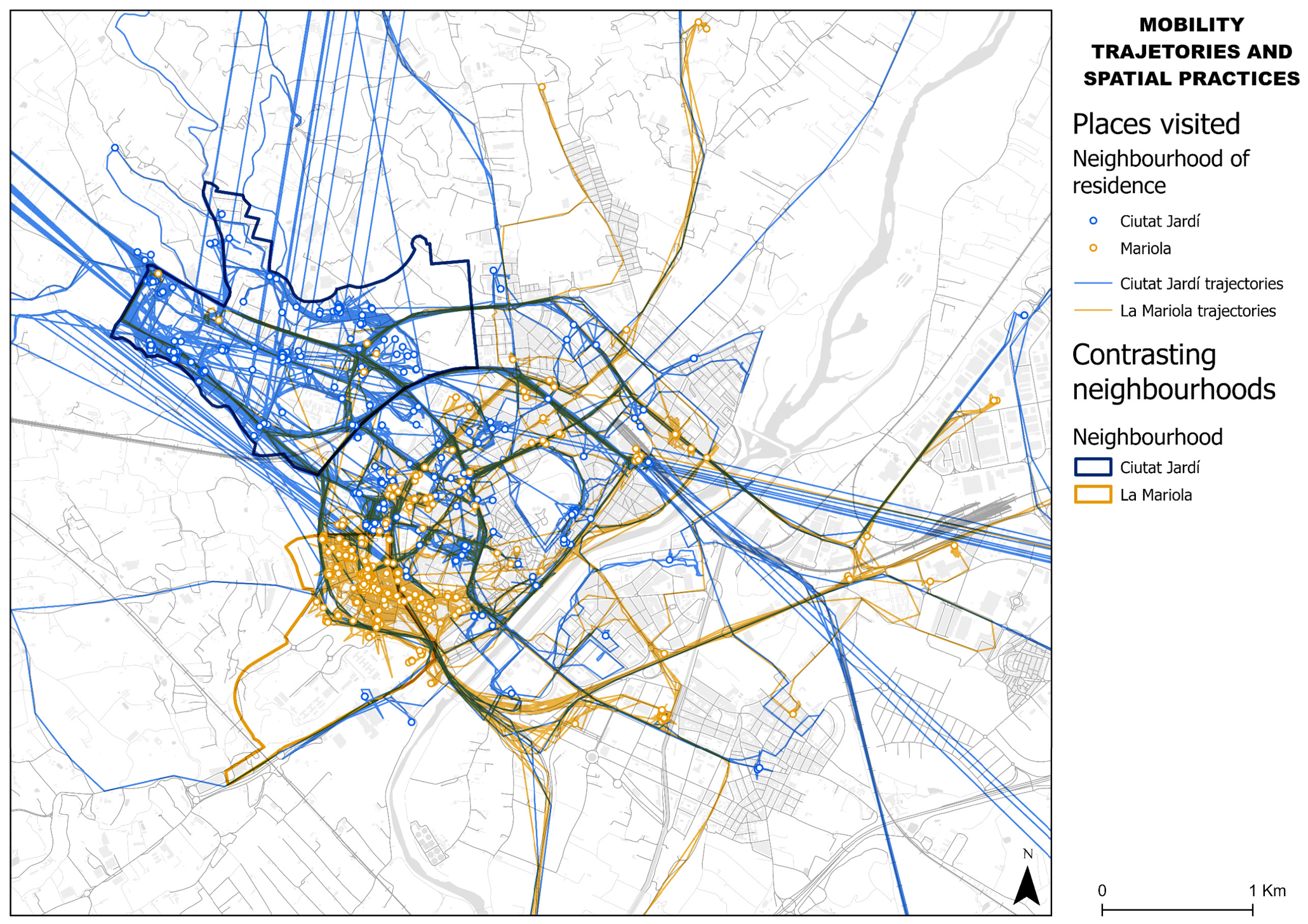
In Ciutat Jardí, trajectories are characterised by a wide territorial extension organised around dispersed functional nodes. Daily mobility connects workplaces, educational centres, services, commercial areas and leisure spaces, producing a network-based urban experience. The use of private cars expands the radius of action and reduces spatial friction, allowing distant locations to be connected without engaging with intermediate areas. As one participant noted, “We use the car for everything” (CJ05). GPS data confirm this pattern, showing high intensity in specific locations and low continuity across intervening spaces. Everyday mobility is structured as a network of selected destinations rather than as a continuous urban fabric.
In La Mariola, trajectories are more spatially concentrated and characterised by a higher density of use within a limited area. Walking is the dominant mode of transport, and daily activities—such as consumption, care and social interaction—are largely organised within or near the neighbourhood. As one resident explained, “I do everything here in my day-to-day life” (LM14). GPS data show strong spatial intensity within a compact perimeter, with repetitive and stabilised routes. Movements beyond the neighbourhood tend to be associated with specific needs and require planning, limiting the overall territorial reach of daily activity.
The map below (
Figure 2) illustrates that the difference lies not in the amount of movement, but in its spatial form: while in Ciutat Jardí (blue vectors and points) mobility is distributed across dispersed nodes connected by motorised travel, in La Mariola (yellow vectors and points) it is concentrated within a compact, walkable area. These contrasting patterns reflect different configurations of the practised city: extensive but segmented in one case, and dense and localised in the other.
Table 4 summarises these differences in terms of territorial extension, modal structure, functional organisation and route repetition. These configurations form the material basis upon which subsequent processes of spatial selection and delimitation are constructed. They also show that accessibility is not simply a question of proximity to urban resources, but of the modal, temporal and practical conditions through which those resources are incorporated into everyday life.
4.2. Centralities, Selective Use and Uneven Access to Urban Resources
Building on the general differences in functional urban use identified in a previous study [
5], this section develops a new analysis of how recurrent destinations are assembled into differentiated systems of everyday centrality. The emphasis is therefore placed not on documenting differences in urban use again, but on examining how particular places acquire practical relevance and become incorporated into unequal configurations of practised accessibility.
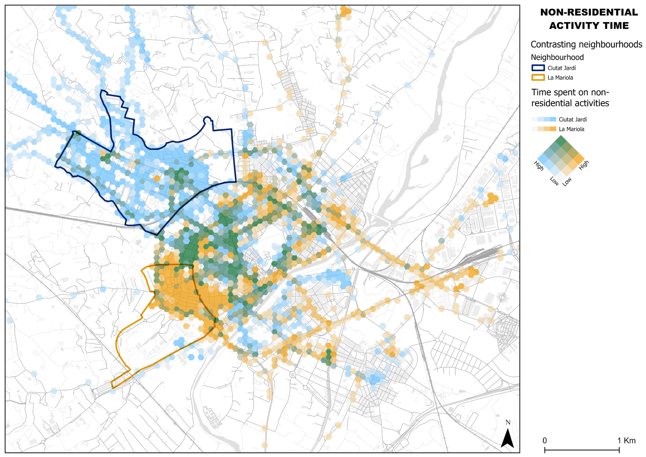
Figure 3 presents a new analytical output developed for this purpose. The sets of blue hexahedrons represent the time spent in non-residential activities by the residents of Ciutat Jardí, and the yellow sets represent the same variable for La Mariola. Greener hexahedrons suggest spatial overlaps between the two groups of residents. The analysis suggest that differences in everyday mobility are closely linked to the production of centralities within the practised city. Rather than simply connecting locations, daily trajectories activate certain places as central while leaving others outside the effective spatial repertoire. Centralities are therefore not only formal nodes within the urban structure, but socially differentiated spaces that become meaningful through repeated use, selective incorporation and everyday relevance.
In Ciutat Jardí, centralities are constructed through elective practices. Residents incorporate specific destinations—related to consumption, services, work, education or leisure—into relatively stable routines (
Figure 3). Selection is guided by convenience, perceived quality and social affinity. As one participant noted, “If I have to go to the [city] centre, I just go and come back” (CJ04), suggesting an instrumental and reversible relationship with urban space. Centrality does not necessarily correspond to the formal city centre, but to a personalised network of recurrent destinations. Large parts of the city remain outside everyday use not because of physical constraints, but because they have limited practical relevance within these selective circuits.
In La Mariola, centralities follow a different logic. The neighbourhood itself functions as the main reference point, concentrating essential and relational activities (
Figure 3). Movements beyond the neighbourhood are typically associated with specific needs—such as administrative tasks, health care, shopping or access to particular services—rather than with a diversification of options. Here, centrality is shaped by proximity, available resources and everyday responsibilities rather than by elective selection. The practised city is therefore organised around a more localised and necessity-based structure of use.
An important finding is the presence of apparently shared centralities, particularly in consolidated urban areas such as commercial zones, administrative areas and parts of the city centre.
Figure 3 shows that spatial overlaps between both groups are concentrated in these areas. However, this spatial coincidence does not imply a shared experience of the city. Rather, it reflects specific functional overlaps. The same locations are accessed from different positions, for different purposes and with different degrees of choice. In this sense, the city may coincide cartographically without converging experientially.
Table 5 summarises these patterns, highlighting differences in the type of centralities, selection criteria, relationship with the city centre, spatial overlaps and degree of choice. These results show that urban inequality is not only reflected in which spaces are accessed, but also in the unequal capacity to select, repeat and appropriate them as part of everyday life. Centralities are therefore not neutral resources equally available to all residents, but are embedded in socially differentiated conditions of mobility, familiarity and practical relevance.
These differentiated patterns of centrality also imply the systematic exclusion or marginalisation of other areas, which remain outside everyday circuits. The next section examines these absences through patterns of avoidance, silence and asymmetric urban boundaries.
4.3. Avoidance, Silence and Asymmetric Urban Boundaries
Interview accounts distinguish non-use from constrained or unrealised activity. In Ciutat Jardí, avoidance tends to take a silent and implicit form. Certain neighbourhoods are simply absent from everyday trajectories and are rarely mentioned in interviews without the need for explicit justification (CJ05; CJ09; CJ14; CJ17). Non-use is typically framed in functional terms—“I have nothing to do there” or “I don’t go through that area”—rather than through explicit negative evaluations. Nevertheless, specific constraints were also reported: CJ09 used the car more than desired because of the lack of public transport; CJ03 relied on family support to overcome schedule incompatibilities; and CJ18 described much of the city as distant from the neighbourhood. Wider car-based mobility therefore cannot automatically be equated with greater freedom. Where non-use was expressed as functional irrelevance, the city is organised as a sufficient network of selected nodes. Areas that are not integrated into this network remain outside the operational horizon of everyday life, even when they are physically traversed.
In La Mariola, avoidance is more frequently articulated and explained. References to non-frequented areas are accompanied by accounts of constraints, effort or discomfort (LM02; LM06; LM14). Some constraints also directly curtailed activities: LM06 reported missing religious activities when unable to arrive on time; LM11 described being unable to go out or travel because of illness and caregiving; and LM15 stated that reduced mobility prevented travelling far. Other accounts linked reduced or less autonomous mobility to cost, carrying burdens and fear (LM02; LM03; LM04; LM13; LM16). In these accounts, the city beyond the neighbourhood is not irrelevant, but experienced as demanding, distant or difficult to access. In contrast to Ciutat Jardí, where non-use appears as a taken-for-granted absence, here spatial limits are verbalised and situated within everyday conditions.
These contrasting patterns indicate that avoidance operates through different, although not mutually exclusive, logics. In Ciutat Jardí, non-use is more often expressed as functional irrelevance, requiring little or no justification. When constraints arise, they are more frequently managed through resources such as private cars or family support. In La Mariola, non-use is more often explicitly associated with effort, discomfort or constraint, with some accounts describing activities that were missed, reduced or undertaken with less autonomy. As a result, similar spatial absences may correspond to different ways of delimiting and experiencing the urban field.
Figure 3 illustrates this asymmetry. Areas without spatial overlap between the two groups are not only the result of residential patterns, but of differentiated processes of selection and exclusion. Even in zones of partial overlap, shared presence does not imply a shared experience of the city.
Table 6 summarises these patterns, highlighting differences in the nature of avoidance, its discursive justification and its relationship to everyday spatial organisation. These findings show that urban boundaries are not only defined by physical barriers but also emerge through everyday practices that shape which parts of the city are included or excluded from routine experience. In this sense, the practised city is shaped as much by what is excluded as by what is included.
4.4. Cognitive Representations, Symbolic Classification and Uneven Urban Knowledge
The mental maps examined in this section were produced during the same interviews used in a previous study, but were not examined. They therefore constitute the principal previously unanalysed empirical material incorporated into this article. Their examination makes it possible to move beyond observed mobility and urban use to investigate how residents cognitively delimit the city, classify neighbourhoods and assign differential relevance and value to urban space. Beyond patterns of use and avoidance, urban inequality is also reflected in how the city is cognitively represented and symbolically classified. Interview data and mental maps show that residents organise urban space through implicit categories that assign differential value to neighbourhoods and structure perceptions of belonging and distance.
In Ciutat Jardí, references to other areas of the city—particularly La Mariola and other working-class neighbourhoods—are often framed from a position of externality and require little elaboration (CJ09; CJ14; CJ17). Distance is expressed as self-evident rather than as something that needs to be justified. The neighbourhood itself is described as a “normal” or appropriate environment, while other areas are implicitly marked as different without the need for explicit evaluation. In La Mariola, by contrast, references to the neighbourhood are more frequently accompanied by explanations, qualifications or defensive narratives (LM02; LM07; LM12), suggesting a more reflexive engagement with external perceptions and a greater need to situate the neighbourhood within broader urban hierarchies.
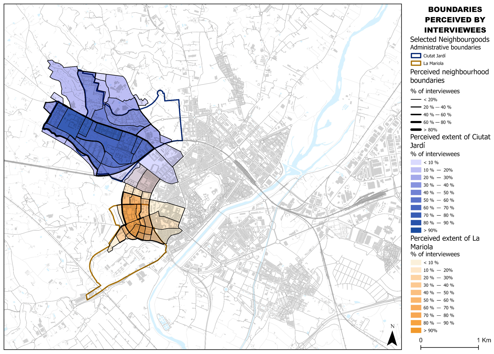
These differences are also evident in how residents delineate their neighbourhoods.
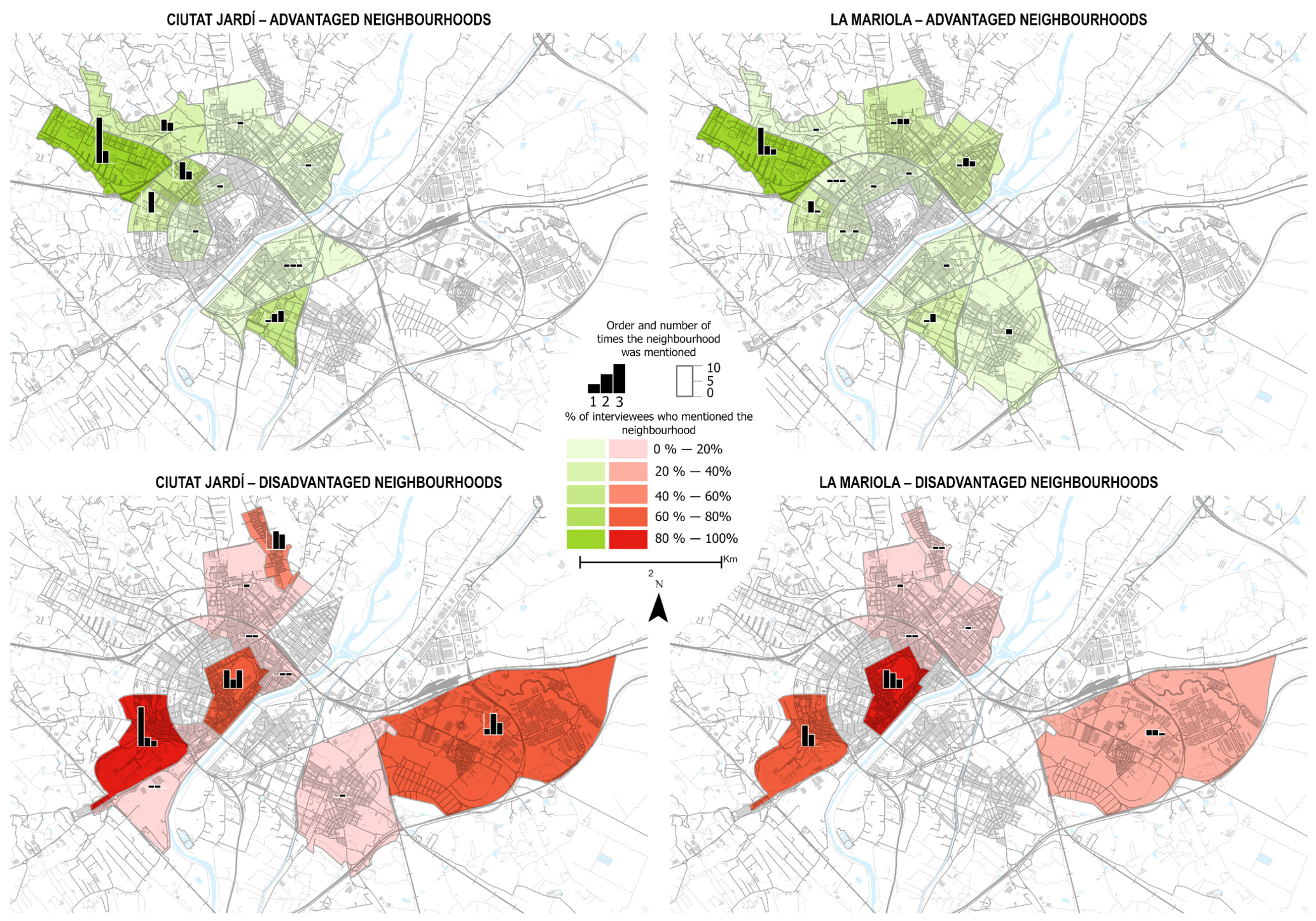
Figure 4 shows how they perceive the boundaries of their neighbourhoods. InCiutat Jardí (purlple polygons), boundaries tend to be broader, more flexible and occasionally expansive, sometimes incorporating adjacent areas. In La Mariola (yellow polygons), delimitations are more compact and clearly defined, often aligned with physical elements such as major roads or topographical features. This contrast indicates different ways of structuring territorial belonging and of relating the neighbourhood to the wider city.
Figure 5 complements this analysis by mapping the neighbourhoods identified as advantaged or disadvantaged in participants’ accounts. The green polygons represent the advantaged neighbourhoods, and the red polygons represent disadvantaged neighbourhoods. The colour gradient indicates the frequency and order of mention by the interviewees. The distribution of mentions reveals not only a shared awareness of socio-spatial differences, but also variations in how these hierarchies are articulated from different residential positions. In Ciutat Jardí, references to disadvantaged areas are relatively limited, and some parts of the city remain largely absent from the cognitive map. In La Mariola, by contrast, differences between neighbourhoods are more explicitly recognised and discussed, often through comparison with other areas of the city.
Examined together (
Figure 4 and
Figure 5), these patterns suggest that the city is selectively represented through a combination of experience, familiarity and valuation. Areas that are frequently used tend to occupy a central position in cognitive maps, while those that are rarely accessed or systematically avoided remain peripheral or absent. As a result, the practised city and the represented city tend to overlap, producing internally coherent but socially differentiated understandings of urban space. The combination of mapped boundaries, named neighbourhoods and everyday trajectories points to a strong alignment between spatial practices and cognitive representations, reinforcing differentiated urban experiences.
These findings indicate that urban space is not only differently used, but also differently structured as a field of familiarity and relevance across social groups.
5. Discussion
The findings show that urban fragmentation in medium-sized cities may operate less through visible spatial separation than through the stabilisation of differentiated everyday spatial practices. In the case analysed, residents of Ciutat Jardí and La Mariola inhabit the same formal city, but their trajectories, centralities, avoided spaces and cognitive representations produce distinct and only partially overlapping urban experiences.
This perspective complements structural approaches to urban fragmentation and socio-spatial inequality, which have emphasised residential segregation, infrastructural differentiation and uneven access to urban resources [
2,
3,
31]. The results suggest that fragmentation may also be produced through routine mobility, selective use, non-use, symbolic classification and spatial familiarity. In contexts of physical proximity, these mechanisms reveal forms of differentiation that remain less visible in analyses based on distance, residential location or the formal distribution of urban resources.
5.1. Everyday Spatial Practices and Activity-Based Segregation
One of the main contributions of the article is to show how urban inequality is reproduced through ordinary and stabilised spatial practices. Daily trajectories, place selection and patterns of use function as micro-level processes that, when repeated over time, generate differentiated urban geographies. In this sense, the results support and extend research on activity-based segregation, which has shown that inequality is not confined to residential location but unfolds across the spaces where everyday life takes place [
12,
13].
The case of Lleida shows that activity spaces are not merely descriptive measures of mobility. They are also expressions of unequal capacities to combine places, organise time, access resources and construct meaningful relations with the city. This finding resonates with approaches that understand mobility as a socially situated practice shaped by resources, obligations, rhythms and constraints [
11,
14,
15], and with time-geographical perspectives that conceptualise trajectories as structured by the intersection of time, space and social conditions [
32,
33].
In Ciutat Jardí, mobility is structured through dispersed, selective and multi-nodal trajectories that enable residents to connect distant locations with relatively low spatial friction. In La Mariola, by contrast, everyday practices are more spatially concentrated, repetitive and locally anchored, reflecting a different configuration of resources, obligations and constraints. The contrast is therefore not simply a difference in distance travelled, but a difference in the temporal, modal and practical organisation of access. These mobility configurations must also be interpreted in relation to unequal economic and temporal resources. Higher household incomes in Ciutat Jardí may facilitate car-supported mobility and discretionary access to dispersed consumption and leisure destinations, whereas lower incomes in La Mariola may increase reliance on proximity and make the cost of transport and activities more relevant to destination choice. However, because participant-level income, working hours and mobility expenditure were not systematically measured, their independent effects cannot be established. Through routine selection, omission and concentration, everyday practices shape the effective geography of opportunities, social interaction and access to resources. The practised city thus emerges as a structured field of unequal access, where differences in mobility, time availability and spatial familiarity translate into differentiated urban experiences.
5.2. Spatial Selection, Avoidance and Uneven Legitimacy
The comparison between both neighbourhoods reveals a key asymmetry in how spatial selection and avoidance are articulated. Differences are not only expressed in the spaces that are used, but also in how non-use is produced, experienced and justified. Absence from everyday trajectories should therefore not be interpreted as a neutral lack of use. It may indicate very different relations to urban space depending on social position, resources, symbolic recognition and territorial legitimacy.
In Ciutat Jardí, avoidance tends to operate as functional irrelevance. Certain areas are simply not incorporated into everyday trajectories and rarely require explicit justification. Non-use is framed in practical terms—linked to routines, destinations, convenience or lack of need—rather than through explicit negative evaluation. From this position, the non-use of certain areas appears normalised and does not usually need to be discursively defended.
In La Mariola, by contrast, avoidance is more frequently verbalised and situated within everyday constraints. References to non-frequented areas are often accompanied by accounts of effort, distance, time limitations, discomfort or lack of resources. Similar spatial absences therefore correspond to different social logics: in one case, non-use appears as an unremarked absence; in the other, it is more often articulated as a situated limitation.
These findings can be related to work on symbolic boundaries and territorial stigma, which emphasises how urban space is differentially classified, valued and legitimised [
18,
19]. They also connect with recent research on territorial stigma, boundary work and subjective neighbourhood boundaries, which shows that urban divisions are negotiated through everyday practices of classification, distancing and spatial use [
27,
34]. In line with Caldeira’s argument, urban divisions are sustained not only by physical barriers, but also by normalised social distances and unequal definitions of what is considered legitimate or appropriate urban space [
24].
Urban inequality is therefore not only reflected in differential access to space, but also in the uneven conditions under which spatial choices are made, justified and recognised as legitimate. This helps to explain why avoidance may be silent and taken for granted in one neighbourhood, while being more explicitly narrated and negotiated in the other.
5.3. Cognitive Representations and Partial Urban Experiences
The analysis of mental maps and neighbourhood classifications shows that the practised city and the represented city are closely connected. Areas that are frequently used tend to acquire cognitive centrality, while those that are rarely accessed, avoided or symbolically distant remain peripheral or absent from urban representations. This finding develops classic insights on cognitive maps and urban legibility, which show that residents do not experience the city as a continuous whole, but through selective configurations of paths, nodes, edges and meaningful places [
25].
The notion of partial urban experiences helps integrate these findings. It does not refer to physically isolated enclaves, but to socially differentiated ways of practising, knowing and interpreting the same urban space. In Ciutat Jardí, the city tends to be represented and used as a selective network of destinations, organised through dispersed and elective trajectories. In La Mariola, everyday spatial practices are more localised, and the cognitive representation of the city is more explicitly structured by boundaries, comparisons and hierarchies.
These results connect with research showing that mobility and situated experience shape spatial knowledge, and that subjective neighbourhood boundaries may reproduce broader territorial divisions and inequalities [
11,
26,
27,
28]. The case of Lleida confirms this relationship: daily practices, spatial familiarity and symbolic classifications are closely aligned. The city is not only differently used, but also differently known, named and hierarchised.
This has implications for how urban fragmentation is conceptualised. Fragmentation does not necessarily require complete separation or the absence of spatial overlap. Groups may share certain centralities or move through the same areas without producing a shared urban experience. This understanding is consistent with recent approaches that interpret urban fragmentation as a multidimensional process involving material, social, symbolic and experiential forms of differentiation [
35]. The city may therefore be formally common, cartographically overlapping and institutionally unified, while remaining experientially differentiated.
From this perspective, unequal everyday geographies are produced through the alignment between spatial practices and cognitive representations. Daily routes, selected centralities, avoided areas and symbolic classifications reinforce one another, shaping how different groups construct their effective city. The divided city is therefore not only a matter of where groups reside, but also of how they practise, know and make sense of urban space.
5.4. Medium-Sized Cities and the Normalisation of Fragmentation
The case analysed highlights the importance of extending the study of urban inequality beyond large metropolitan contexts [
36,
37,
38]. In medium-sized cities, relatively compact urban forms and spatial proximity between socially contrasting areas may suggest conditions for greater integration. However, the findings indicate that proximity alone does not necessarily reduce socio-spatial differentiation. This is particularly relevant in Southern European medium-sized cities, where compactness, historical neighbourhood trajectories and short distances may coexist with persistent forms of segregation and fragmentation [
8,
10,
37].
In this context, fragmentation appears less because of large-scale spatial separation and more as an outcome of the differential structuring of everyday spatial practices and representations. Differences in mobility patterns, activity spaces, centralities, avoidance and cognitive maps produce uneven urban experiences even where physical distances are limited. This is precisely what makes the medium-sized city analytically relevant: by reducing the explanatory weight of metropolitan distance, it makes visible mechanisms of inequality that operate through everyday practice, symbolic boundaries and practised accessibility.
Rather than being absent, fragmentation in medium-sized cities may become less visible and more normalised within everyday life. Compactness may therefore conceal, rather than dissolve, fragmented urban experiences. Medium-sized cities should not be treated as simple or less fragmented urban environments, but as contexts in which fragmentation may operate through subtle, routinised and socially normalised mechanisms.
5.5. From Potential to Practised Accessibility: Implications for Spatial Governance
The findings have implications for spatial governance and urban planning. If fragmentation is reproduced through everyday spatial practices, then planning cannot rely exclusively on potential accessibility, formal proximity or the spatial distribution of services. The presence of facilities, centralities or public spaces within a compact urban structure does not guarantee that they are equally incorporated into everyday life. Access depends not only on where resources are located, but also on the temporal, modal, cognitive and symbolic conditions through which they become practically available.
The concept of practised accessibility helps capture this difference. It shifts attention from the formal possibility of access to the effective incorporation of urban resources into daily routines. In the case analysed, some residents are able to organise the city as a flexible and elective network of destinations, while others rely more heavily on proximate, repetitive and necessity-based spatial repertoires. These differences are not reducible to distance; they are shaped by transport options, time constraints, responsibilities, familiarity, stigma, perceived legitimacy and everyday confidence in using different parts of the city.
For spatial governance, this implies that non-use, avoidance and cognitive absence should be treated as relevant urban evidence. Places that are formally accessible but absent from everyday repertoires may indicate barriers that are not captured by standard measures of proximity. Likewise, shared centralities should not automatically be interpreted as integrated urban spaces, since spatial coincidence may reflect only punctual functional overlap without interaction, recognition or shared meaning.
Urban planning therefore needs to move from planning for potential accessibility to planning for practised accessibility. This does not mean replacing conventional accessibility indicators, but complementing them with evidence on daily trajectories, activity spaces, lived boundaries, perceived legitimacy and spatial familiarity. Such an approach would allow planning and governance frameworks to identify hidden fractures in compact cities and to address not only the distribution of urban resources, but also the unequal conditions through which different groups access, combine and appropriate them in everyday life. In Lleida, these principles could translate into reviewing public transport routes, frequencies and interchange conditions to improve connections between La Mariola and dispersed employment, educational, health and leisure destinations; providing affordable services and activities in shared centralities; and creating spaces that encourage recurrent and meaningful contact between different social groups. Such shared settings may foster mutual recognition and more inclusive and welcoming urban environments, helping to reduce territorial stigma, unfamiliarity and fear.
6. Conclusions
This paper has examined how urban inequality is reproduced through everyday spatial practices in a medium-sized city. Moving beyond residential segregation, the analysis has shown that unequal urban experiences are structured through differentiated mobility patterns, selective centralities, uneven forms of avoidance and socially differentiated cognitive representations of urban space.
The case of Lleida demonstrates that physical proximity does not necessarily produce shared urban experience. Residents of Ciutat Jardí and La Mariola inhabit the same formal city, but their everyday spatial repertoires differ markedly. In Ciutat Jardí, mobility is more dispersed, elective and organised through selected nodes. In La Mariola, daily practices are more concentrated, repetitive and anchored in proximate spaces. These differences are reflected not only in where people go, but also in which places become central, which remain absent, and how the city is cognitively and symbolically organised.
The article contributes to theoretical debates on urban fragmentation by developing the notion of unequal everyday geographies. This concept captures how urban inequality is produced through the combined effect of mobility, spatial selection, avoidance, symbolic classification and spatial familiarity. Fragmentation is therefore not only a condition of residential separation or infrastructural discontinuity, but also a process through which the city becomes differently practised, known and made meaningful by different social groups.
The focus on a medium-sized city provides a specific analytical contribution. In compact urban contexts, where socially contrasting neighbourhoods may be located relatively close to one another, fragmentation may be less visible than in large metropolitan areas. However, the findings show that compactness can conceal differentiated urban experiences. Urban inequality in medium-sized cities is not necessarily weaker but may be organised through more subtle and normalised everyday mechanisms.
Regarding methodology, the combination of GPS tracking, in-depth interviews and mental maps has proved useful for identifying dimensions of inequality that remain difficult to capture through conventional indicators. The triangulation of trajectories, narratives and cognitive representations makes it possible to analyse not only access to urban resources, but their effective incorporation into daily life.
The findings also have implications for spatial governance and urban planning. Addressing urban fragmentation requires moving beyond the spatial distribution of services, facilities and infrastructures towards their effective use and appropriation in everyday life. Planning should therefore consider not only potential accessibility, but also the temporal, modal, cognitive and symbolic conditions that shape practised accessibility.
The study is based on an in-depth analysis of two neighbourhoods within a single city, and the GPS sub-sample is exploratory. Its aim is not statistical generalisation, but the identification of mechanisms through which urban inequality is organised and experienced in everyday life. Future research could extend this approach through comparative analyses across medium-sized cities and through larger samples that examine differences by age, gender, life stage and household structure.
Ultimately, the article shows that urban inequality is produced not only by where people live, but by how they practise, select, avoid, know and attribute legitimacy to urban space in everyday life.