Landscape Ecological Risk Evolution and Its Nonlinear Driving Mechanisms in a Topographically Constrained River-Valley Basin: A Case Study of the Taiyuan Section of the Fen River Basin

 , ,
, ,
Abstract
1. Introduction
2. Materials and Methods
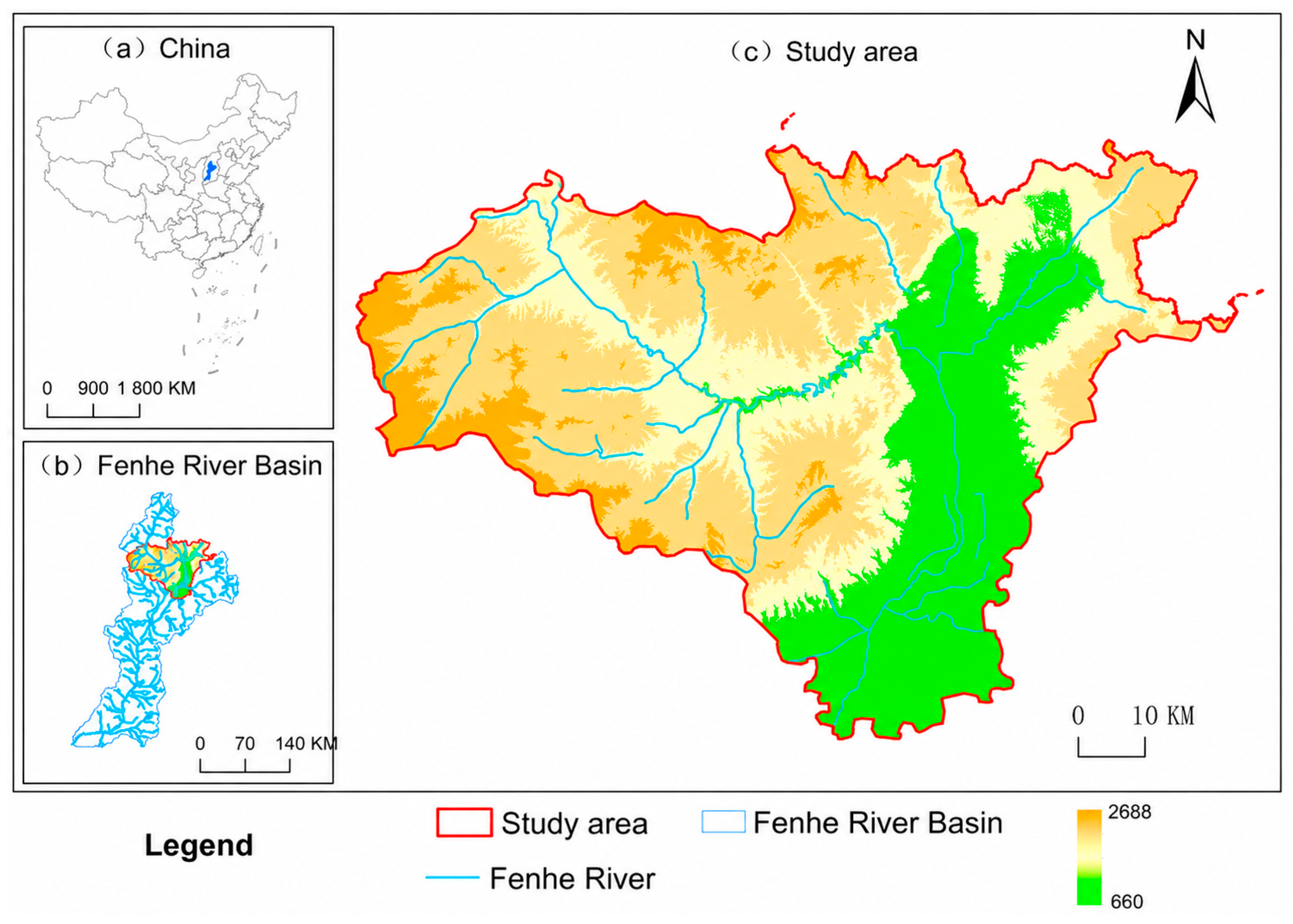
2.1. Study Area
2.2. Data Sources
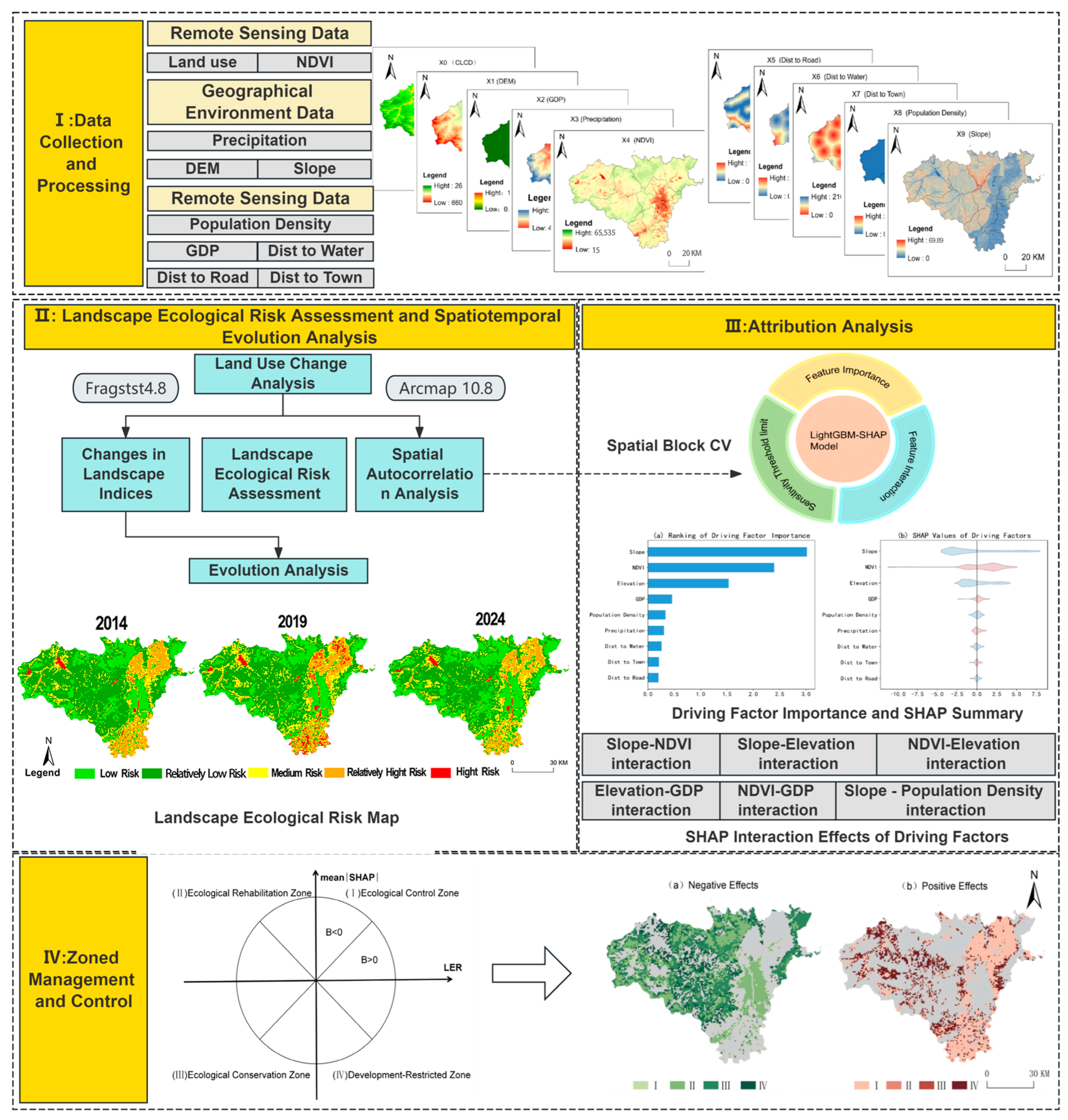
2.3. Analytical Framework
2.4. Landscape-Pattern Analysis and Landscape Ecological Risk Assessment
2.5. Analysis of the Drivers of Landscape Ecological Risk
2.5.1. Spatial Autocorrelation Analysis
2.5.2. LightGBM-SHAP Attribution Analysis
3. Results
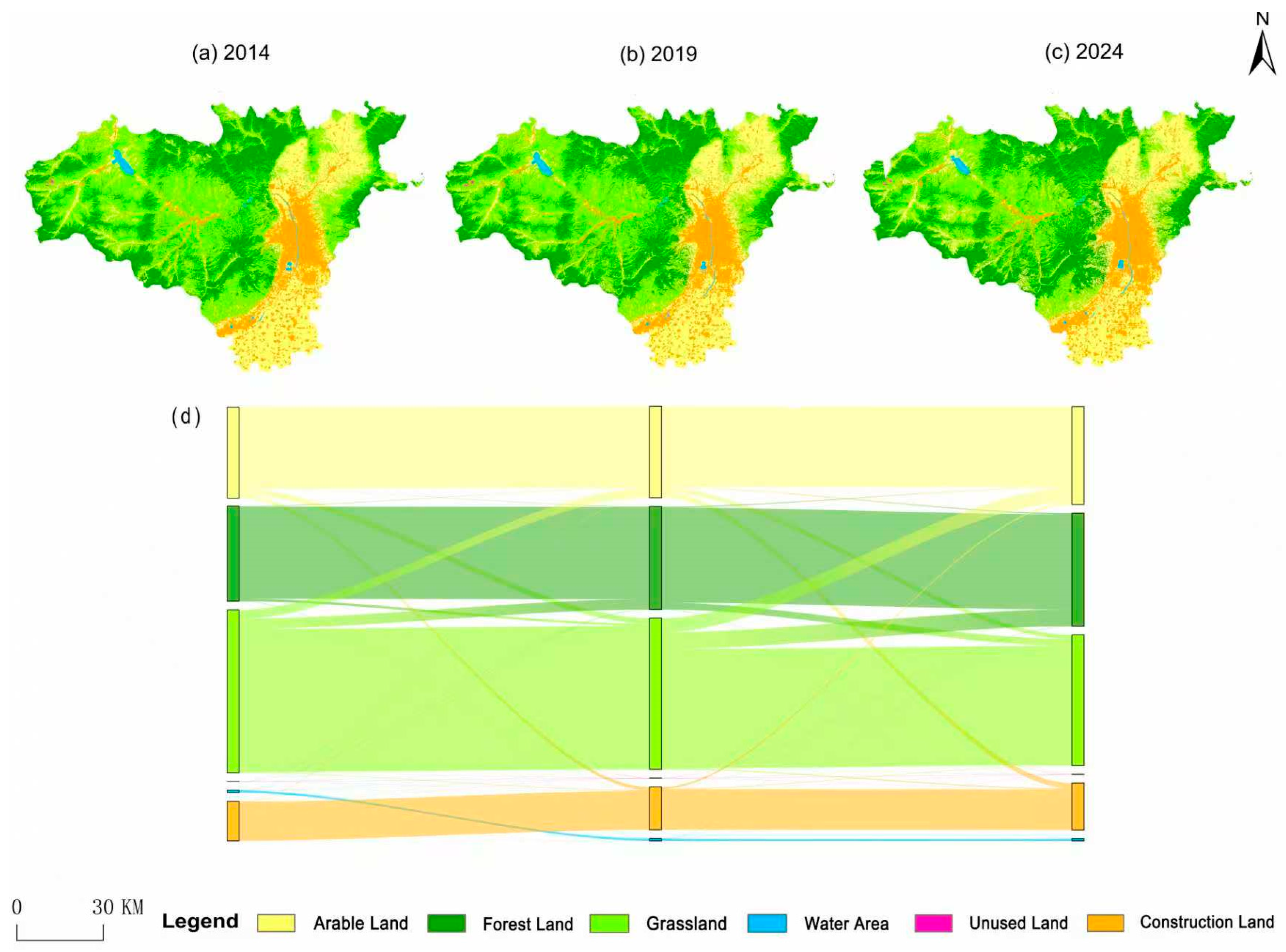
3.1. Land-Use and Landscape-Pattern Changes
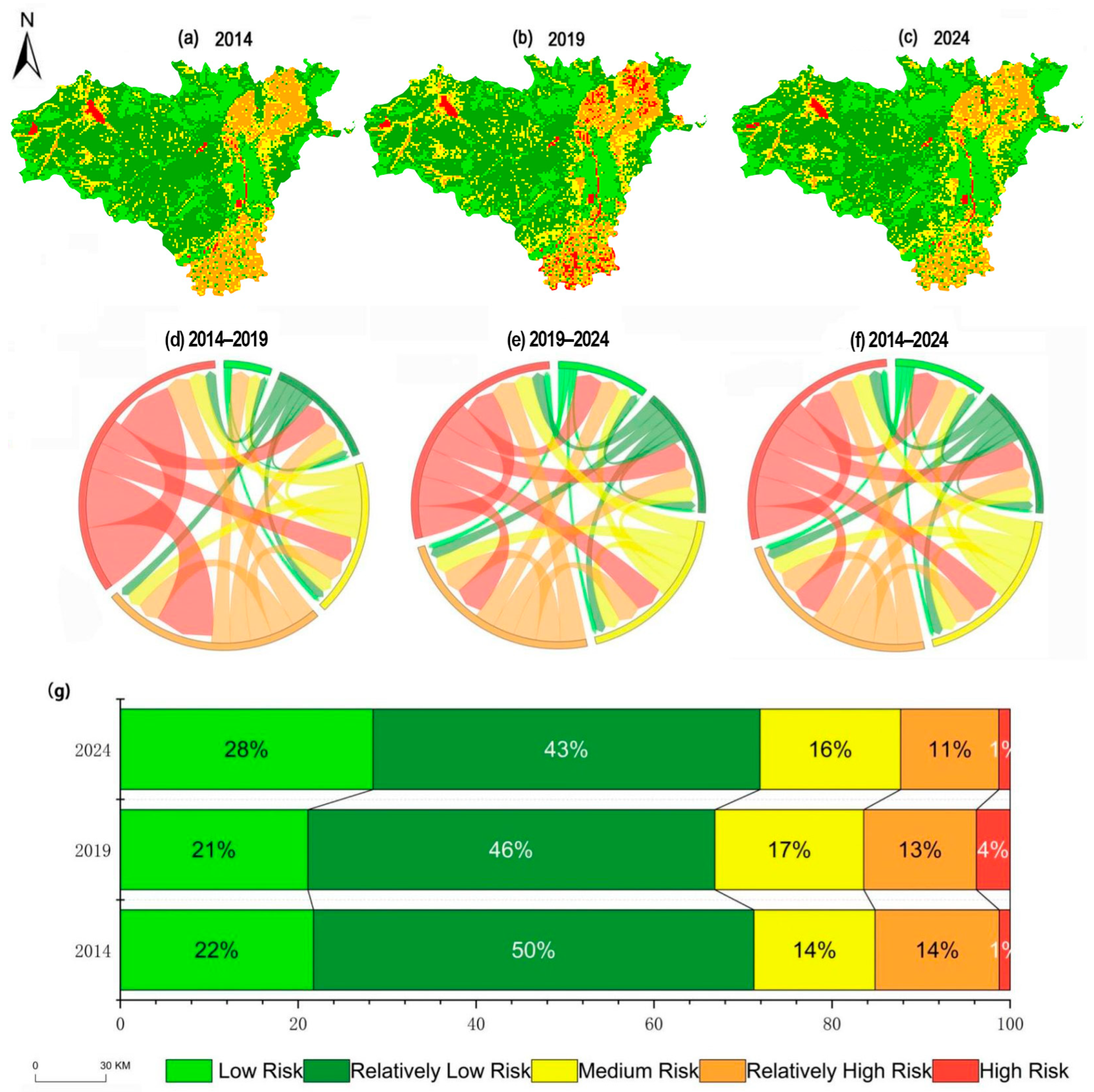
3.2. Landscape Ecological Risk Assessment
3.3. Spatial Attribution of Landscape Ecological Risk
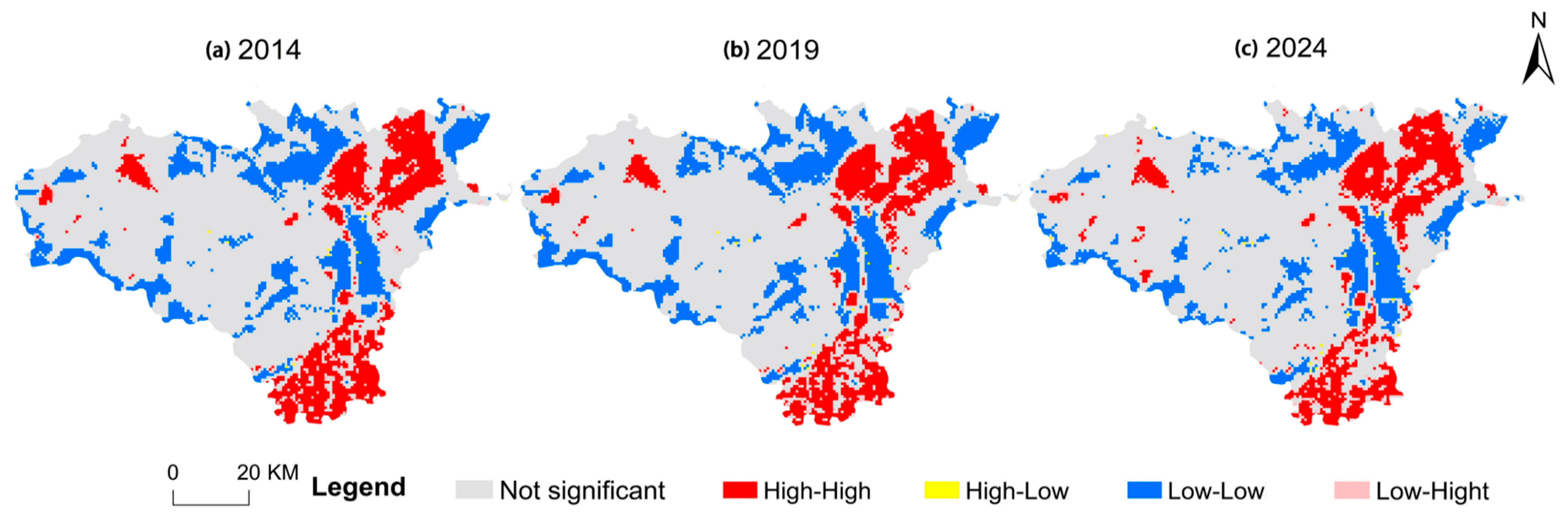
3.3.1. Spatial Autocorrelation Analysis
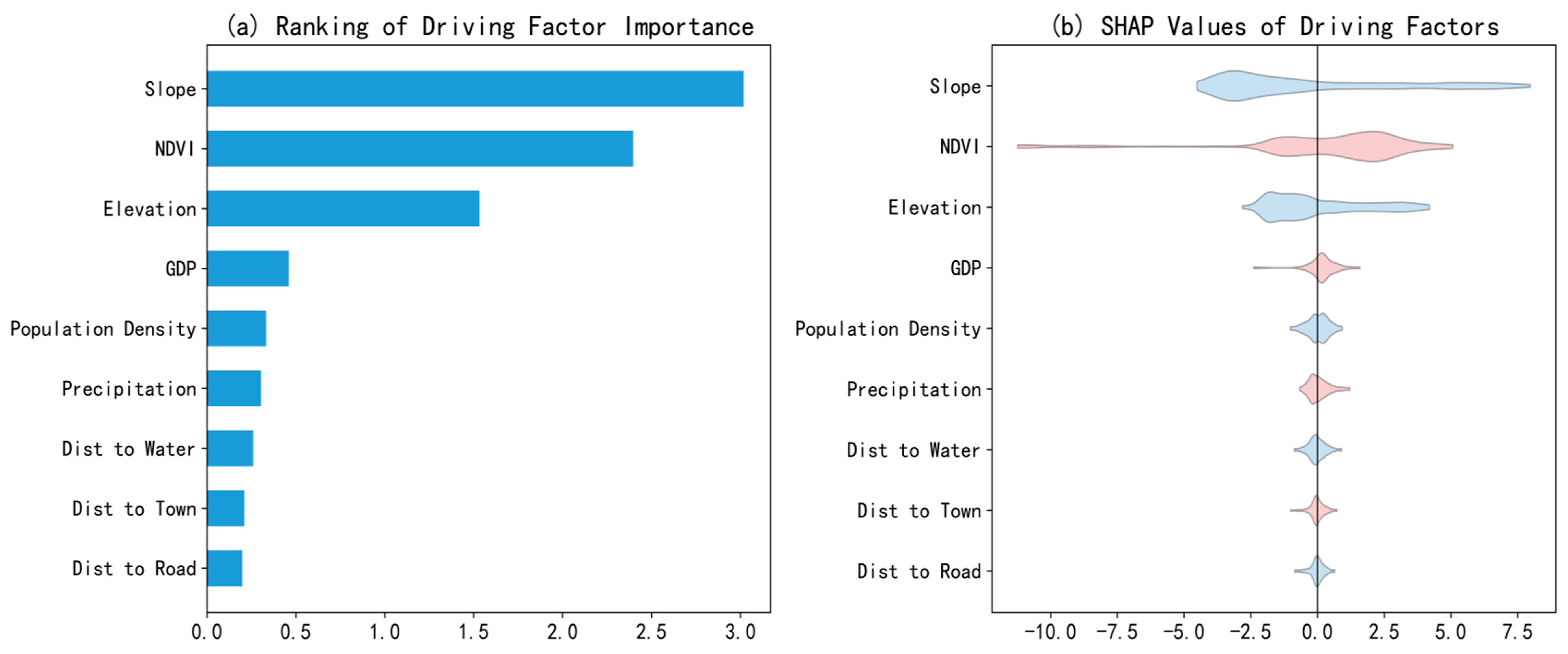
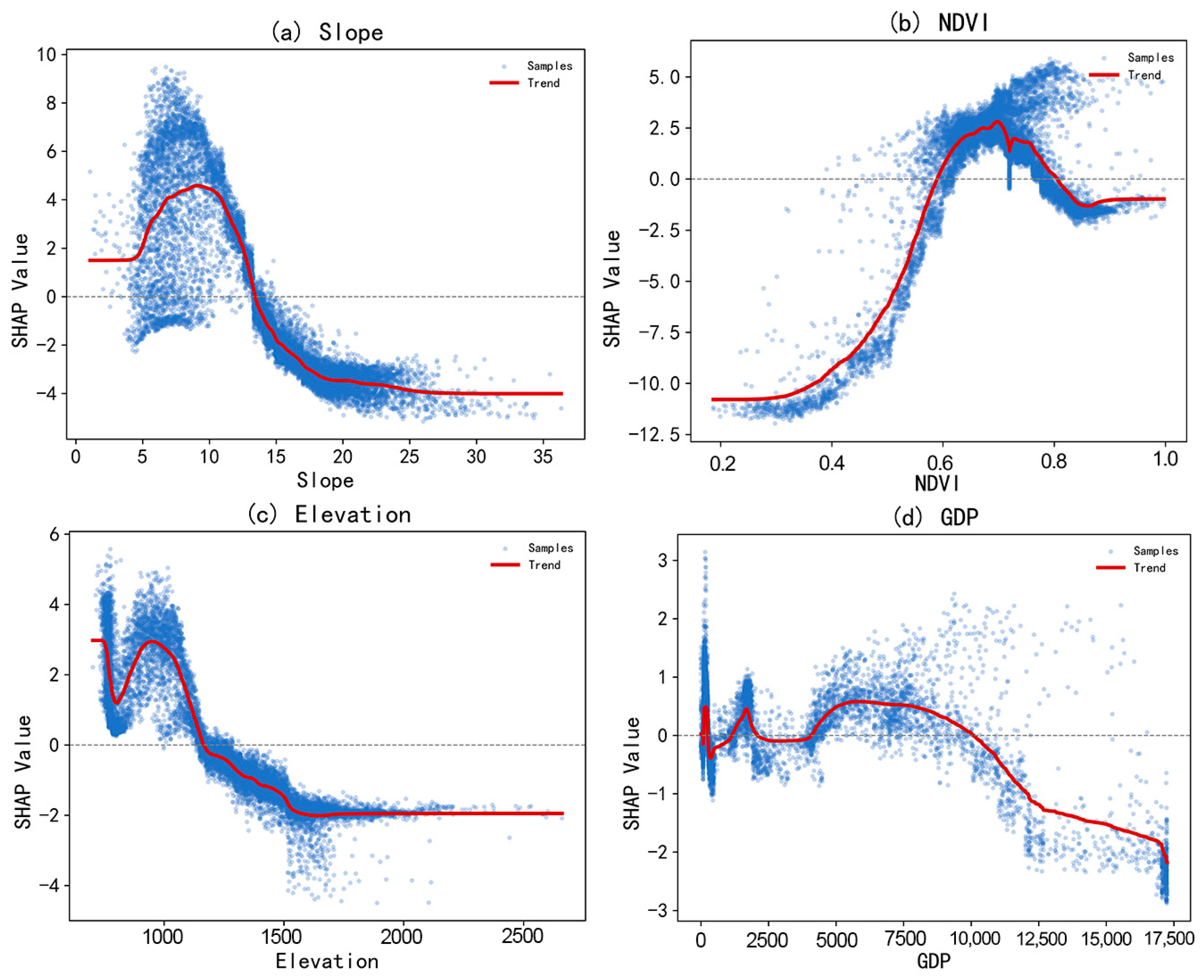
3.3.2. Dominant Drivers of Landscape Ecological Risk
3.3.3. Interactions Among the Dominant Drivers
4. Discussion
4.1. Temporal Evolution of Landscape Ecological Risk
4.2. Spatial Differentiation and Its Evolution
4.3. Nonlinear Driving Mechanisms and Threshold Effects
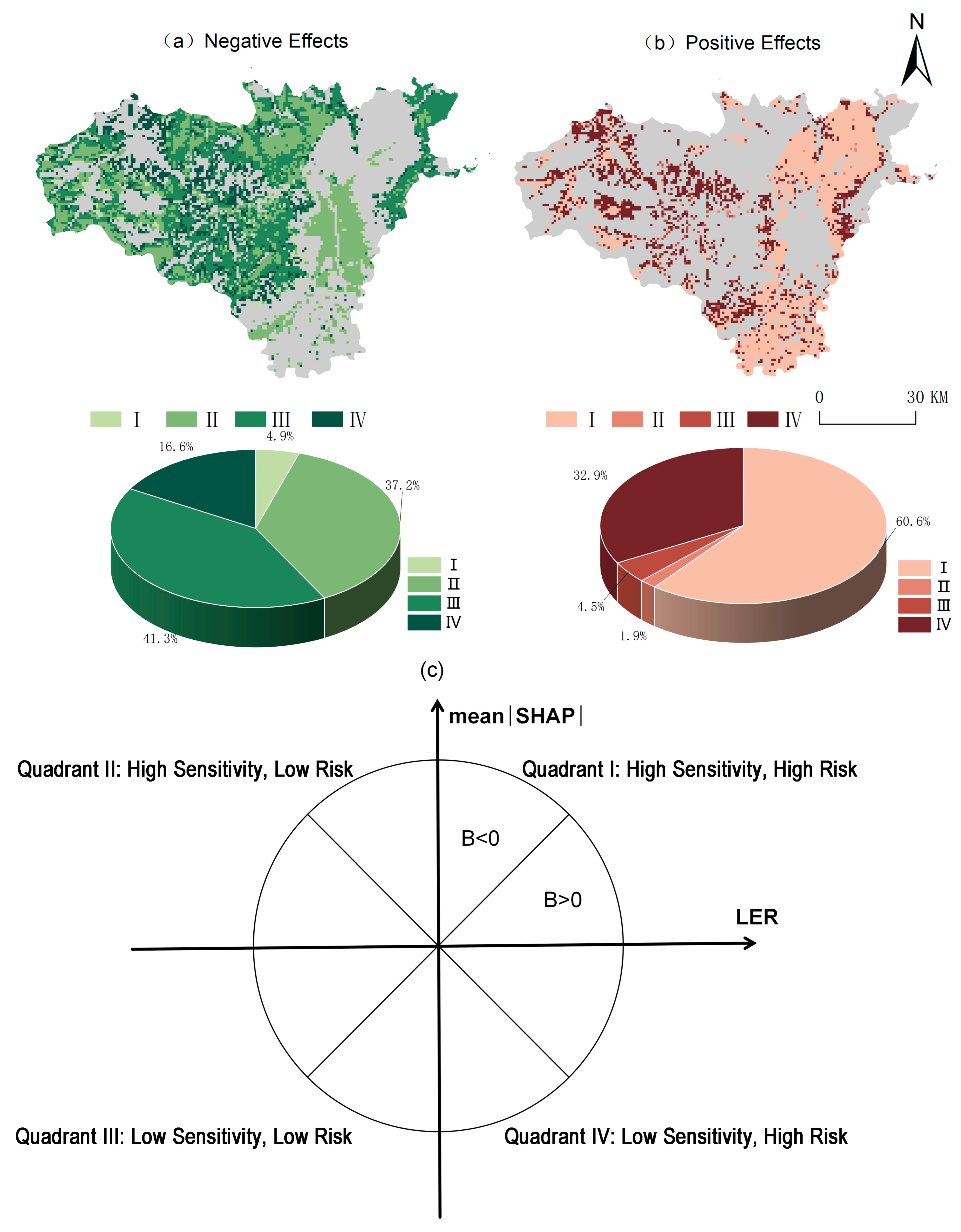
4.4. Differentiated Spatial Management and Policy Implications
4.5. Limitations and Future Research
5. Conclusions
- (1)
- Land use and landscape structure followed a fragmentation-to-integration trajectory. Between 2014 and 2024, forest land, urban and industrial-mining land, and cropland increased by 284.53 km2, 115.58 km2, and 106.72 km2, respectively, whereas grassland, water bodies, and unused land declined. NP increased from 2014 to 2019 and then decreased from 2019 to 2024, indicating that fragmentation first intensified and subsequently weakened. SHDI increased by approximately 3.3%, reflecting greater landscape diversity. Overall, the landscape shifted from a more irregular and fragmented configuration toward a more regular and integrated one.
- (2)
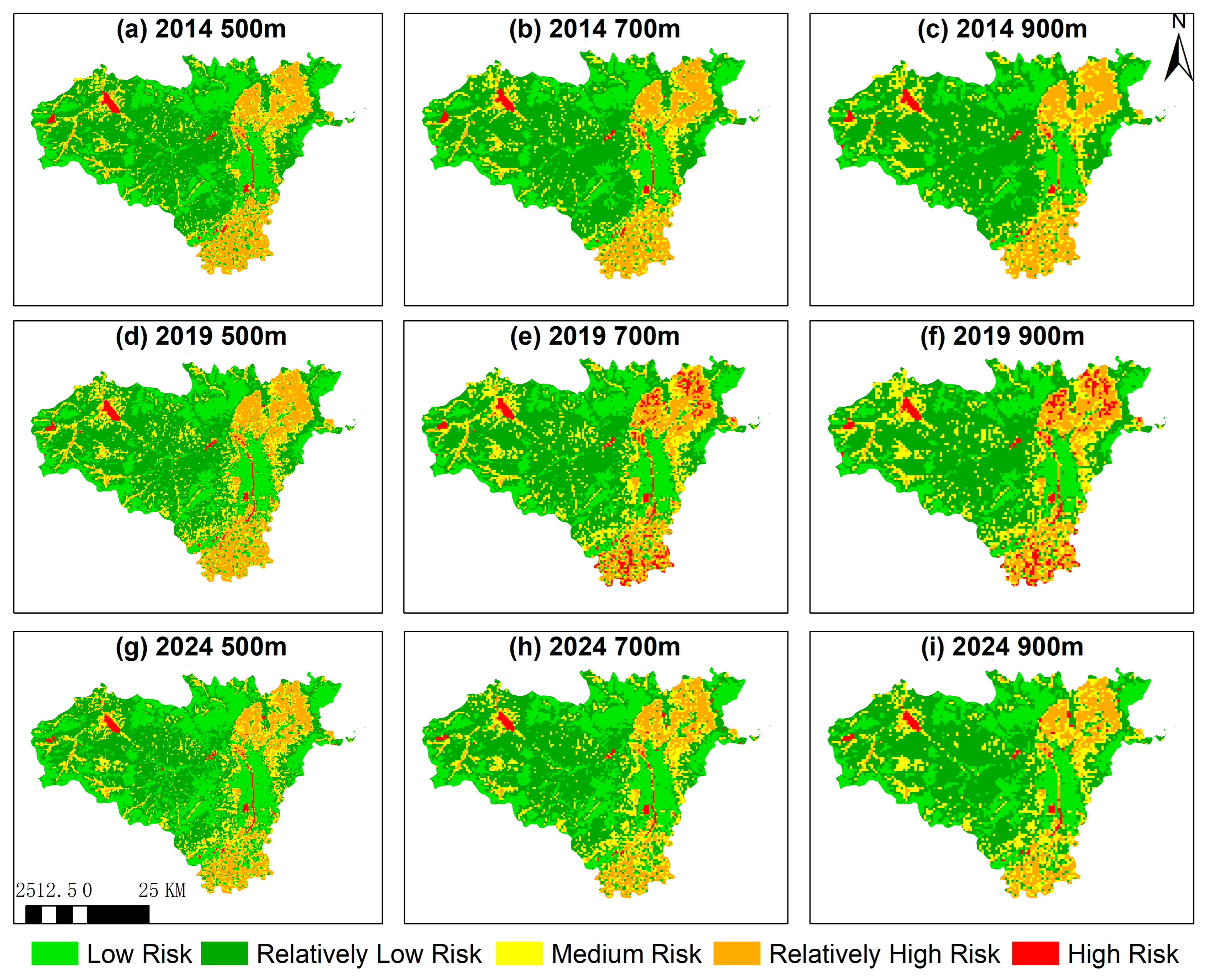
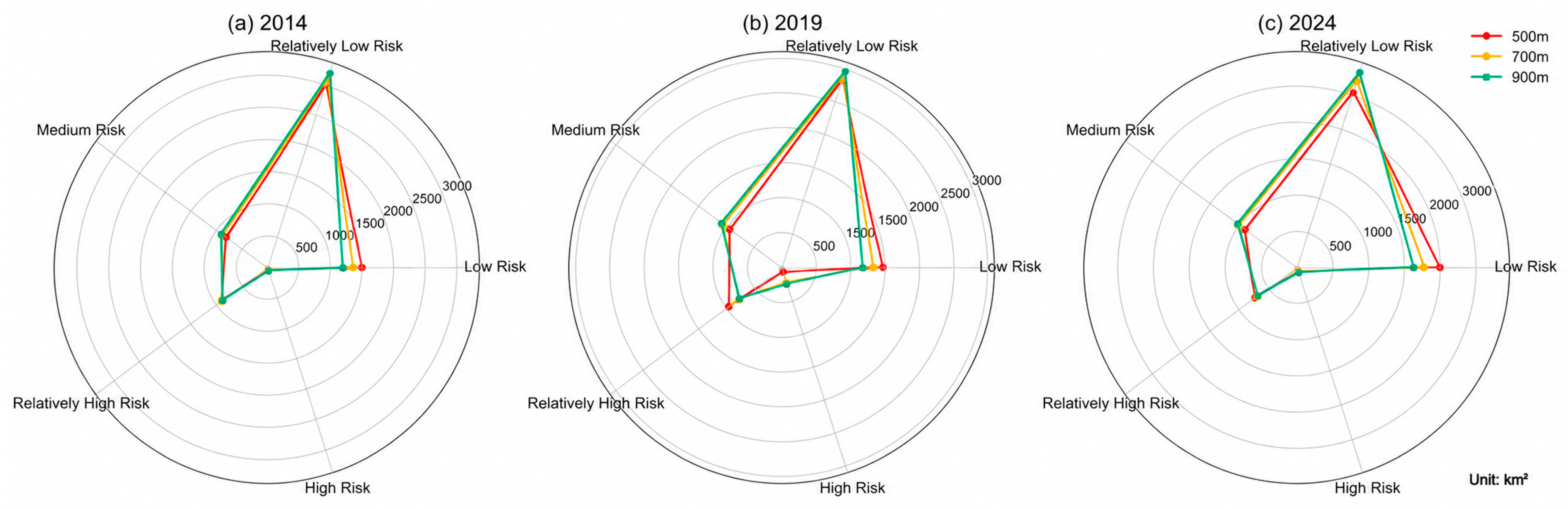
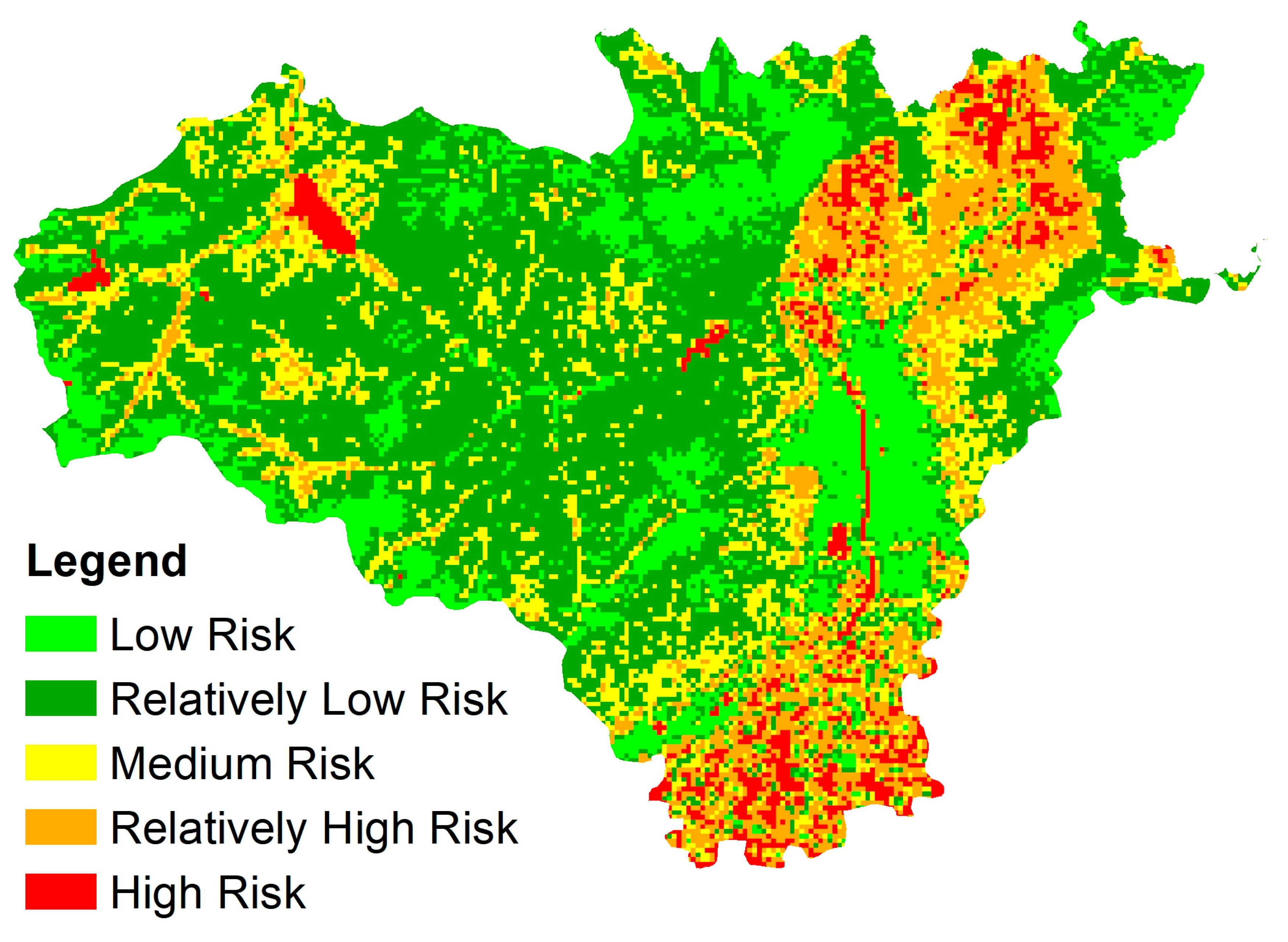
- LER exhibited a fluctuating temporal pattern and clear spatial differentiation. Low- and relatively low-risk zones dominated, covering 71% of the study area. Low-risk zones declined initially and then expanded sharply, including an increase of 457.90 km2 during 2019–2024; medium- and high-risk zones showed the opposite trajectory, while relatively high-risk zones declined continuously by 2.92%. Low- and relatively low-risk zones were concentrated mainly in the northern and central parts of the study area, whereas medium- and high-risk zones occurred primarily in the northeast, south, and a small area in the northwest. High-risk zones were closely associated with water bodies. Following ecological protection and restoration during 2019–2024, many higher-risk zones transitioned to lower-risk classes, indicating overall mitigation of LER.
- (3)
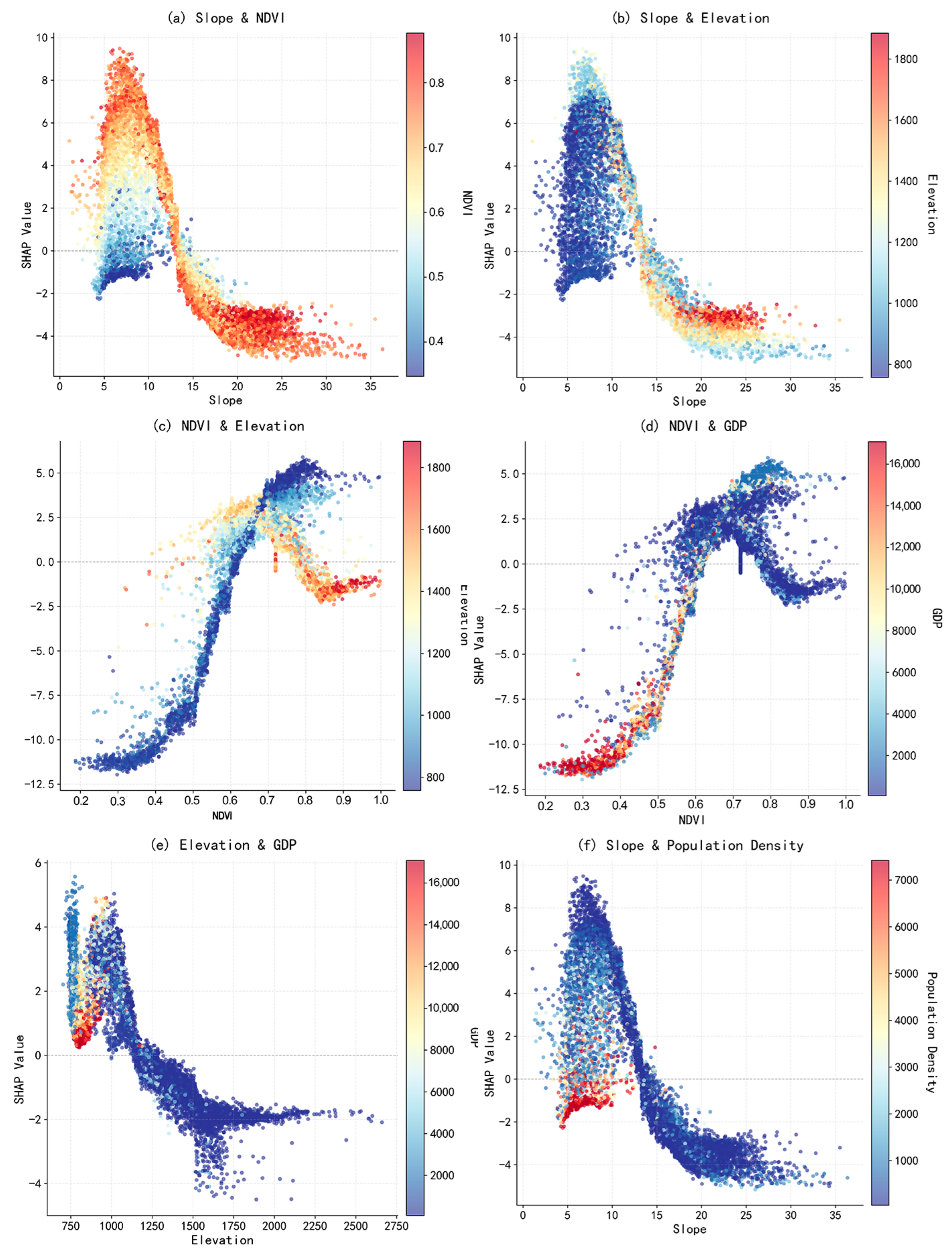
- Natural factors dominated the spatial differentiation of LER and exhibited pronounced nonlinear effects. The principal drivers ranked as follows: slope > NDVI > elevation > GDP. Slope increased LER primarily between 5° and 13° but reduced it below 5° and above 13°. NDVI followed an inverted U-shaped relationship, with the greatest positive contribution at 0.60–0.75, while elevation increased risk below approximately 1200 m and reduced it above this threshold. Interactions among the factors highlighted the constraint imposed by topography on human activity: risk was lowest in high-elevation areas with dense vegetation, whereas low-elevation, low-GDP areas made large positive contributions because of extensive land expansion.
- (4)
- Integrating current risk with driver sensitivity enabled more precise zoning and management. Landscape ecological risk in the study area was predominantly influenced by negative effects, accounting for 60.12%, with most areas exhibiting relatively low risk levels and trends toward stability or improvement. Positive effects accounted for 39.88% and were mainly concentrated in croplands along the urban fringe, areas along the Fen River, and urban expansion frontiers, where ecological risks were relatively high and showed an upward trend, thus requiring priority management. By integrating risk level, magnitude of change, and direction of influence, the “state–driver” zoning framework addresses the limitations of conventional risk-based zoning and facilitates differentiated and forward-looking management of landscape ecological risk.
Author Contributions
Funding
Data Availability Statement
Conflicts of Interest
Appendix A
Appendix A.1


Appendix A.2

References
- Pickens, A.H.; Hansen, M.C.; Song, Z.; Poulson, A.; Komarova, A.; Baggett, A.; Kerr, T.; Mikus, A.; Dominguez, C.O.; Tyukavina, A.; et al. Rapid monitoring of global land change. Nat. Commun. 2025, 16, 8948. [Google Scholar] [CrossRef] [Scilit] [PubMed]
- Soni, H.; Yadav, R.K.; Patra, S.K. Global impact of urbanization on ecosystems: A comprehensive bibliometric analysis. Nat. Hazards Res. 2025, 5, 21–35. [Google Scholar] [CrossRef] [Scilit]
- Du, L.; Dong, C.; Kang, X.; Qian, X.; Gu, L. Spatiotemporal evolution of land cover changes and landscape ecological risk assessment in the Yellow River Basin, 2015–2020. J. Environ. Manag. 2023, 332, 117149. [Google Scholar] [CrossRef] [Scilit] [PubMed]
- Seto, K.C.; Güneralp, B.; Hutyra, L.R. Global forecasts of urban expansion to 2030 and direct impacts on biodiversity and carbon pools. Proc. Natl. Acad. Sci. USA 2012, 109, 16083–16088. [Google Scholar] [CrossRef] [Scilit] [PubMed]
- Cheng, X.; Zhang, Y.; Nie, W.; Wang, Y.; Wang, J.; Xu, B. Landscape ecological risk assessment and influencing factor analysis of basins in suburban areas of large cities—A case study of the Fuchunjiang River Basin, China. Front. Ecol. Evol. 2023, 11, 1184273. [Google Scholar] [CrossRef] [Scilit]
- Tonetti, V.; Pena, J.C.; Scarpelli, M.D.; Sugai, L.S.; Barros, F.M.; Anunciação, P.R.; Santos, P.M.; Tavares, A.L.; Ribeiro, M.C. Landscape heterogeneity: Concepts, quantification, challenges and future perspectives. Environ. Conserv. 2023, 50, 83–92. [Google Scholar] [CrossRef] [Scilit]
- Guo, H.; Cai, Y.; Li, B.; Wan, H.; Yang, Z. An improved approach for evaluating landscape ecological risks and exploring its coupling coordination with ecosystem services. J. Environ. Manag. 2023, 348, 119277. [Google Scholar] [CrossRef] [Scilit] [PubMed]
- Li, S.; Tu, B.; Zhang, Z.; Wang, L.; Zhang, Z.; Che, X.; Wang, Z. Exploring new methods for assessing landscape ecological risk in key basin. J. Clean. Prod. 2024, 461, 142633. [Google Scholar] [CrossRef] [Scilit]
- Zhang, Z.; Yu, H.; He, N.; Jin, G. Future land use simulation model-based landscape ecological risk prediction under the localized shared socioeconomic pathways in the Xiangjiang River Basin, China. Environ. Sci. Pollut. Res. 2024, 31, 22774–22789. [Google Scholar] [CrossRef] [Scilit] [PubMed]
- Deng, R.; Ding, X.; Wang, J. Landscape ecological risk assessment and spatial pattern evolution analysis of the Central Yunnan Urban Agglomeration from 1995 to 2020 based on land use/cover change. Sustainability 2023, 15, 16641. [Google Scholar] [CrossRef] [Scilit]
- Du, J.; Liu, B.; Jing, M.; Zhou, Y.; Yan, Q.; Li, G. Construction of ecological security pattern of arid area based on landscape ecological risk assessment: A case study of the Wu-Chang-Shi urban agglomeration. Environ. Sci. Pollut. Res. 2024, 31, 45622–45635. [Google Scholar] [CrossRef] [Scilit] [PubMed]
- Yang, N.; Zhang, T.; Li, J.; Feng, P.; Yang, N. Landscape ecological risk assessment and driving factors analysis based on optimal spatial scales in Luan River Basin, China. Ecol. Indic. 2024, 169, 112821. [Google Scholar] [CrossRef] [Scilit]
- Sui, X.; Sun, Y.; Wang, X.; Yuan, J. Research on ecological quality and restoration of fragile mining areas in the Yellow River Basin—The case of Xiegou coal mine. Ecol. Indic. 2025, 174, 113426. [Google Scholar] [CrossRef] [Scilit]
- Li, X.; Li, S.; Zhang, Y.; O’Connor, P.J.; Zhang, L.; Yan, J. Landscape ecological risk assessment under multiple indicators. Land 2021, 10, 739. [Google Scholar] [CrossRef] [Scilit]
- Lin, X.; Wang, Z. Landscape ecological risk assessment and its driving factors of multi-mountainous city. Ecol. Indic. 2023, 146, 109823. [Google Scholar] [CrossRef] [Scilit]
- Xue, L.; Zhu, B.; Wu, Y.; Wei, G.; Liao, S.; Yang, C.; Wang, J.; Zhang, H.; Ren, L.; Han, Q. Dynamic projection of ecological risk in the Manas River basin based on terrain gradients. Sci. Total Environ. 2019, 653, 283–293. [Google Scholar] [CrossRef] [Scilit] [PubMed]
- Mo, W.; Wang, Y.; Zhang, Y.; Zhuang, D. Impacts of road network expansion on landscape ecological risk in a megacity, China: A case study of Beijing. Sci. Total Environ. 2017, 574, 1000–1011. [Google Scholar] [CrossRef] [Scilit] [PubMed]
- Lin, Y.; Zhang, F.; Jin, Y.; Wen, L.; Yu, Y.; Zhang, L.; Weng, A.; Ge, Y. Spatial non-stationarity effects of the driving factors on landscape ecological risk: A case of the Xiamen-Zhangzhou-Quanzhou Urban Agglomeration, China. Ecol. Indic. 2024, 167, 112660. [Google Scholar] [CrossRef] [Scilit]
- Zhang, X.; Yu, J.; Feng, H.; Yao, L.; Li, X.; Du, H.; Liu, Y. Landscape ecological risk and drivers of land-use transition under the perspective of differences in topographic gradient. Land 2024, 13, 876. [Google Scholar] [CrossRef] [Scilit]
- Zhu, C.; Zhang, X.; Zhou, M.; He, S.; Gan, M.; Yang, L.; Wang, K. Impacts of urbanization and landscape pattern on habitat quality using OLS and GWR models in Hangzhou, China. Ecol. Indic. 2020, 117, 106654. [Google Scholar] [CrossRef] [Scilit]
- Chen, H.; Chen, H.; Huang, X.; Zhang, S.; He, T.; Gao, Z. Landscape ecological risk assessment and driving factor analysis in southwest China. Sci. Rep. 2024, 14, 23208. [Google Scholar] [CrossRef] [Scilit] [PubMed]
- Liu, L.; Wei, J.; Luo, P.; Zhang, Y.; Wang, Y.; Elbeltagi, A.; Zainol, M.R.R.M.A. A novel quantity assessment of landscape ecological risk using human-nature driving mechanism for sustainable society. Sci. Total Environ. 2024, 947, 173892. [Google Scholar] [CrossRef] [Scilit] [PubMed]
- Qiao, B.; Yang, H.; Cao, X.; Zhou, B.; Wang, N.A. Driving mechanisms and threshold identification of landscape ecological risk: A nonlinear perspective from the Qilian Mountains, China. Ecol. Indic. 2025, 173, 113342. [Google Scholar] [CrossRef] [Scilit]
- Zeng, J.; Wu, J.; Chen, W. Coupling analysis of land use change with landscape ecological risk in China: A multi-scenario simulation perspective. J. Clean. Prod. 2024, 435, 140518. [Google Scholar] [CrossRef] [Scilit]
- Li, M.; Abuduwaili, J.; Liu, W.; Feng, S.; Saparov, G.; Ma, L. Application of geographical detector and geographically weighted regression for assessing landscape ecological risk in the Irtysh River Basin, Central Asia. Ecol. Indic. 2024, 158, 111540. [Google Scholar] [CrossRef] [Scilit]
- Yu, T.; Bao, A.; Xu, W.; Guo, H.; Jiang, L.; Zheng, G.; Yuan, Y.; Nzabarinda, V. Exploring variability in landscape ecological risk and quantifying its driving factors in the Amu Darya Delta. Int. J. Environ. Res. Public Health 2020, 17, 79. [Google Scholar]
- Wang, W.; Xue, X.; Wang, Z.; Zhang, Q. Multiscale driving mechanisms and spatial non-stationarity of landscape ecological risk based on an OPGD–MGWR framework: Evidence from township-level units in the Nanjing metropolitan area (NMA), China. Ecol. Indic. 2026, 186, 114840. [Google Scholar] [CrossRef] [Scilit]
- Li, H.; Zhang, S.; Zeng, Y.; Xu, Z.; Yang, X.; Liu, Y. Multiscale landscape ecological risk response to natural and social factors in China: Thresholds identification. Habitat Int. 2026, 168, 103691. [Google Scholar] [CrossRef] [Scilit]
- Gao, J.; Pan, N.; Zhou, D. Integrating Landscape Ecological Risk and Ecosystem Services for Ecological Zoning in the Qilian Mountain National Park. Ecosyst. Health Sustain. 2025, 11, 0441. [Google Scholar] [CrossRef] [Scilit]
- Wu, Y.; Luo, M.; Ding, S.; Han, Q. Using a Light Gradient-Boosting Machine–Shapley Additive Explanations Model to Evaluate the Correlation Between Urban Blue–Green Space Landscape Spatial Patterns and Carbon Sequestration. Land 2024, 13, 1965. [Google Scholar] [CrossRef] [Scilit]
- He, N.; Ding, R. A dual-method approach integrating dynamic QCA and LightGBM-SHAP algorithms to uncover the configuration paths and key drivers of water resource green efficiency in China. Ecol. Indic. 2025, 175, 113540. [Google Scholar] [CrossRef] [Scilit]
- Liu, S.; Zhang, L.; Chi, Y.; Fu, L.; Wang, J.; Wang, X. Evaluating the Coupling Coordination Degree of the Water-Energy-Ecology System in the Yellow River Basin. Ecol. Indic. 2025, 182, 114461. [Google Scholar] [CrossRef] [Scilit]
- Wang, Y.; Wang, X.; Zhang, W.; Man, W.; Liu, M.; Jiao, L. Spatiotemporal evolution of landscape ecological risk and its driving factors of the Beijing–Tianjin–Hebei major mineral belt, 1985–2022. Sci. Rep. 2025, 15, 2425. [Google Scholar] [CrossRef] [Scilit] [PubMed]
- Du, J.; Bi, S.; Zhang, Y.; Chen, M. Landscape ecological risk assessment and driving factors in Guyi Basin cultural heritage sites: A multi-scenario simulation perspective. npj Herit. Sci. 2026, 14, 36. [Google Scholar] [CrossRef] [Scilit]
- Li, Z.; Ding, X.; Wang, S.; Wang, H.; Yan, Y.; Zhang, T.; Long, Y. Landscape Ecological Risk Assessment and Driving Factors During 1995–2024 in the Dianzhong Five Lakes Region of Yunnan Province, China Using the XGBoost-SHAP and Random Forest Models. Land 2026, 15, 508. [Google Scholar] [CrossRef] [Scilit]
- Zhang, S.; Feng, Z.; Kang, L.; Wu, K. Unraveling nonlinear landscape pattern effects on habitat quality: A Yangtze river delta case study for data-driven management. J. Environ. Manag. 2025, 394, 127665. [Google Scholar] [CrossRef] [Scilit] [PubMed]
- Wang, H.; Zhang, Y.A.; Niu, J.; Huang, W.; Yin, J.; Liu, D. Trade-offs between land use intensity and ecosystem services in ecologically critical areas from a decoupling perspective and their policy implications. Ecol. Indic. 2026, 182, 114505. [Google Scholar] [CrossRef] [Scilit]
- Qiao, Q.; Zhen, Z.; Liu, L.; Luo, P. The Construction of Ecological Security Pattern under Rapid Urbanization in the Loess Plateau: A Case Study of Taiyuan City. Remote Sens. 2023, 15, 1523. [Google Scholar] [CrossRef] [Scilit]
- Li, Q.; Ma, B.; Zhao, L.; Mao, Z.; Luo, L.; Liu, X. Landscape Ecological Risk Evaluation Study under Multi-Scale Grids—A Case Study of Bailong River Basin in Gansu Province, China. Water 2023, 15, 3777. [Google Scholar] [CrossRef] [Scilit]
- Xie, H.; Wang, P.; Huang, H. Ecological Risk Assessment of Land Use Change in the Poyang Lake Eco-economic Zone, China. Int. J. Environ. Res. Public Health 2013, 10, 328–346. [Google Scholar] [CrossRef] [Scilit] [PubMed]
- De Lange, H.J.; Sala, S.; Vighi, M.; Faber, J.H. Ecological vulnerability in risk assessment—A review and perspectives. Sci. Total Environ. 2010, 408, 3871–3879. [Google Scholar] [CrossRef] [Scilit] [PubMed]
- Guo, Y.; Guo, W. Landscape ecological risk analysis of urban agglomeration in the central basin of Shanxi from the perspective of “production-living-ecological spaces. Chin. J. Ecol. 2022, 41, 1813–1824. (In Chinese) [Google Scholar]
- Anselin, L. Spatial Econometrics: Methods and Models; Springer Science & Business Media: Berlin/Heidelberg, Germany, 1988. [Google Scholar]
- Anselin, L. Local indicators of spatial association—LISA. Geogr. Anal. 1995, 27, 93–115. [Google Scholar] [CrossRef] [Scilit]
- Ke, G.; Meng, Q.; Finley, T.; Wang, T.; Chen, W.; Ma, W.; Ye, Q.; Liu, T.-Y. LightGBM: A Highly Efficient Gradient Boosting Decision Tree. Adv. Neural Inf. Process. Syst. 2017, 30, 3146–3154. [Google Scholar]
- Cuomo, S.; Di Cola, V.S.; Giampaolo, F.; Rozza, G.; Raissi, M.; Piccialli, F. Scientific machine learning through physics–informed neural networks: Where we are and what’s next. J. Sci. Comput. 2022, 92, 88. [Google Scholar] [CrossRef] [Scilit]
- Friedman, J.H. Greedy function approximation: A gradient boosting machine. Ann. Stat. 2001, 29, 1189–1232. [Google Scholar] [CrossRef] [Scilit]
- Draper, N.R.; Smith, H. Applied Regression Analysis; John Wiley & Sons: Hoboken, NJ, USA, 1998. [Google Scholar]
- Lundberg, S.M.; Lee, S.I. A unified approach to interpreting model predictions. Adv. Neural Inf. Process. Syst. 2017, 30, 4768–4777. [Google Scholar]
- Gao, H.; Song, W. Assessing the Landscape Ecological Risks of Land-Use Change. Int. J. Environ. Res. Public Health 2022, 19, 13945. [Google Scholar] [CrossRef] [Scilit] [PubMed]
- Nafi’Shehab, Z.; Jamil, N.R.; Aris, A.Z.; Shafie, N.S. Spatial variation impact of landscape patterns and land use on water quality across an urbanized watershed in Bentong, Malaysia. Ecol. Indic. 2021, 122, 107254. [Google Scholar] [CrossRef] [Scilit]
- Chen, J.; Zhang, L.; Zhao, S.; Zong, H. Assessing Land-Use Conflict Potential and Its Correlation with LULC Based on the Perspective of Multi-Functionality and Landscape Complexity: The Case of Chengdu, China. Land 2023, 12, 742. [Google Scholar] [CrossRef] [Scilit]
- Gao, C.; Zhang, W.; Li, C.; Fan, Y. Landscape Ecological Risk Assessment and Analysis of Driving Factors in the Zhang–Wei River Basin, North China Plain. Sustainability 2026, 18, 2170. [Google Scholar] [CrossRef] [Scilit]
- Guo, B.; Xu, M.; Zhang, R.; Luo, W. A new monitoring index for ecological vulnerability and its application in the Yellow River Basin, China from 2000 to 2022. J. Arid Land 2024, 16, 1163–1182. [Google Scholar] [CrossRef] [Scilit]
- Karimian, H.; Zou, W.; Chen, Y.; Xia, J.; Wang, Z. Landscape ecological risk assessment and driving factor analysis in Dongjiang river watershed. Chemosphere 2022, 307, 135835. [Google Scholar] [CrossRef] [Scilit] [PubMed]





| Data Category | Dataset | Data Year | Original Spatial Resolution | Processed Spatial Resolution | Data Source |
|---|---|---|---|---|---|
| Remote sensing data | Land use | 2014, 2019, and 2024 | 30 m | 30 m | China Land Cover Dataset, Wuhan University (https://zenodo.org/records/4417809, accessed on 6 July 2025). |
| NDVI | 2024 | 30 m | 30 m | Resource and Environmental Science Data Platform (https://www.resdc.cn/Default.aspx, accessed on 2 July 2025). | |
| Geographical environment data | Precipitation | 2024 | 30 m | 30 m | Resource and Environmental Science Data Platform (https://www.resdc.cn/Default.aspx, accessed on 2 July 2025). |
| DEM | 2024 | 30 m | 30 m | Resource and Environmental Science Data Platform (https://www.resdc.cn/Default.aspx, accessed on 2 July 2025). | |
| Slope | Consistent with the DEM | Consistent with the DEM | 30 m | Derived from the DEM using ArcMap 10.8 | |
| Socio-economic data | Population density | 2023 | 1 km | 30 m | Resource and Environmental Science Data Platform (https://www.resdc.cn/Default.aspx, accessed on 2 July 2025). |
| GDP | 2023 | 1 km | 30 m | Resource and Environmental Science Data Platform (https://www.resdc.cn/Default.aspx, accessed on 2 July 2025). | |
| Other factors | Water system | 2020 | Vector data | 30 m | Resource and Environmental Science Data Platform (https://www.resdc.cn/Default.aspx, accessed on 3 July 2025). |
| Road network * | 2020 | Vector data | 30 m | Resource and Environmental Science Data Platform (https://www.resdc.cn/Default.aspx, accessed on 3 July 2025). | |
| Urban settlements | 2023 | Vector data | 30 m | Resource and Environmental Science Data Platform (https://www.resdc.cn/Default.aspx, accessed on 3 July 2025). |
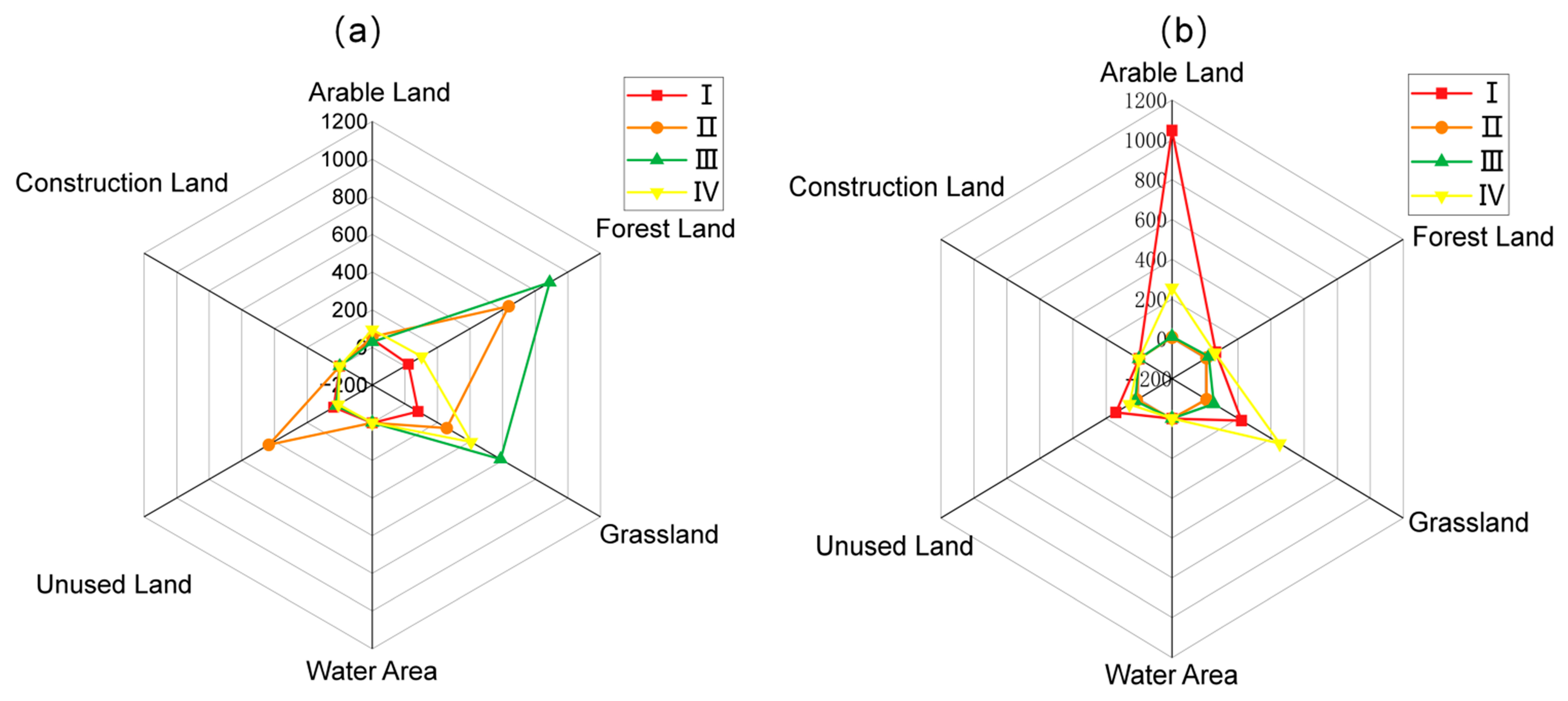
| Weight Adjustment Scenario | ||||||||||||
|---|---|---|---|---|---|---|---|---|---|---|---|---|
| Year | Arable Land (+20%) | Forest Land (+20%) | Grassland (+20%) | Water Area (+20%) | Construction Land (+20%) | Unused Land (+20%) | Arable Land (−20%) | Forest Land (−20%) | Grassland (−20%) | Water Area (−20%) | Construction Land (−20%) | Unused Land (−20%) |
| 2014 | 0.995 ** | 0.988 ** | 0.986 ** | 1.000 ** | 0.996 ** | 1.000 ** | 0.985 ** | 0.995 ** | 0.971 ** | 1.000 ** | 0.997 ** | 1.000 ** |
| 2019 | 0.994 ** | 0.993 ** | 0.987 ** | 1.000 ** | 0.998 ** | 1.000 ** | 0.983 ** | 0.996 ** | 0.981 ** | 1.000 ** | 0.998 ** | 1.000 ** |
| 2024 | 0.995 ** | 0.982 ** | 0.987 ** | 1.000 ** | 0.996 ** | 1.000 ** | 0.984 ** | 0.993 ** | 0.962 ** | 1.000 ** | 0.997 ** | 1.000 ** |
| ** p < 0.01 | ||||||||||||
| Landscape Metric | 2014 | 2019 | 2024 | Change, 2014–2024 (%) |
|---|---|---|---|---|
| Number of patches (NP) | 63,100 | 68,032 | 57,825 | −8.36 |
| Percentage of like adjacencies (PLADJ) | 90.318 | 89.696 | 90.344 | 0.03 |
| Fractal dimension (FRAC) | 1.357 | 1.363 | 1.322 | −2.54 |
| Clumpiness index (CLUMPY) | 90.388 | 89.766 | 90.415 | 0.03 |
| Shannon’s diversity index (SHDI) | 1.314 | 1.336 | 1.358 | 3.34 |
| Cluster Type | 2014 | 2019 | 2024 |
|---|---|---|---|
| Not significant | 8632 | 8696 | 9170 |
| High–high | 2055 | 1965 | 1876 |
| High–low | 13 | 18 | 21 |
| Low–high | 109 | 117 | 129 |
| Low–low | 2427 | 2440 | 2040 |
Disclaimer/Publisher’s Note: The statements, opinions and data contained in all publications are solely those of the individual author(s) and contributor(s) and not of MDPI and/or the editor(s). MDPI and/or the editor(s) disclaim responsibility for any injury to people or property resulting from any ideas, methods, instructions or products referred to in the content. |
© 2026 by the authors. Licensee MDPI, Basel, Switzerland. This article is an open access article distributed under the terms and conditions of the Creative Commons Attribution (CC BY) license.
Share and Cite
Li, J.; Fan, X.; Li, Y.; Zhu, C.; Yang, Y.; Yue, X.; Zhang, L.; Zhao, Z.; Cao, X.; Ma, Y. Landscape Ecological Risk Evolution and Its Nonlinear Driving Mechanisms in a Topographically Constrained River-Valley Basin: A Case Study of the Taiyuan Section of the Fen River Basin. Land 2026, 15, 1438. https://doi.org/10.3390/land15081438
Li J, Fan X, Li Y, Zhu C, Yang Y, Yue X, Zhang L, Zhao Z, Cao X, Ma Y. Landscape Ecological Risk Evolution and Its Nonlinear Driving Mechanisms in a Topographically Constrained River-Valley Basin: A Case Study of the Taiyuan Section of the Fen River Basin. Land. 2026; 15(8):1438. https://doi.org/10.3390/land15081438
Chicago/Turabian StyleLi, Junqi, Xiang Fan, Yanshu Li, Chuxin Zhu, Yuqi Yang, Xiucheng Yue, Liyijia Zhang, Zhoumeng Zhao, Xinyue Cao, and Yujie Ma. 2026. "Landscape Ecological Risk Evolution and Its Nonlinear Driving Mechanisms in a Topographically Constrained River-Valley Basin: A Case Study of the Taiyuan Section of the Fen River Basin" Land 15, no. 8: 1438. https://doi.org/10.3390/land15081438
APA StyleLi, J., Fan, X., Li, Y., Zhu, C., Yang, Y., Yue, X., Zhang, L., Zhao, Z., Cao, X., & Ma, Y. (2026). Landscape Ecological Risk Evolution and Its Nonlinear Driving Mechanisms in a Topographically Constrained River-Valley Basin: A Case Study of the Taiyuan Section of the Fen River Basin. Land, 15(8), 1438. https://doi.org/10.3390/land15081438