1. Introduction
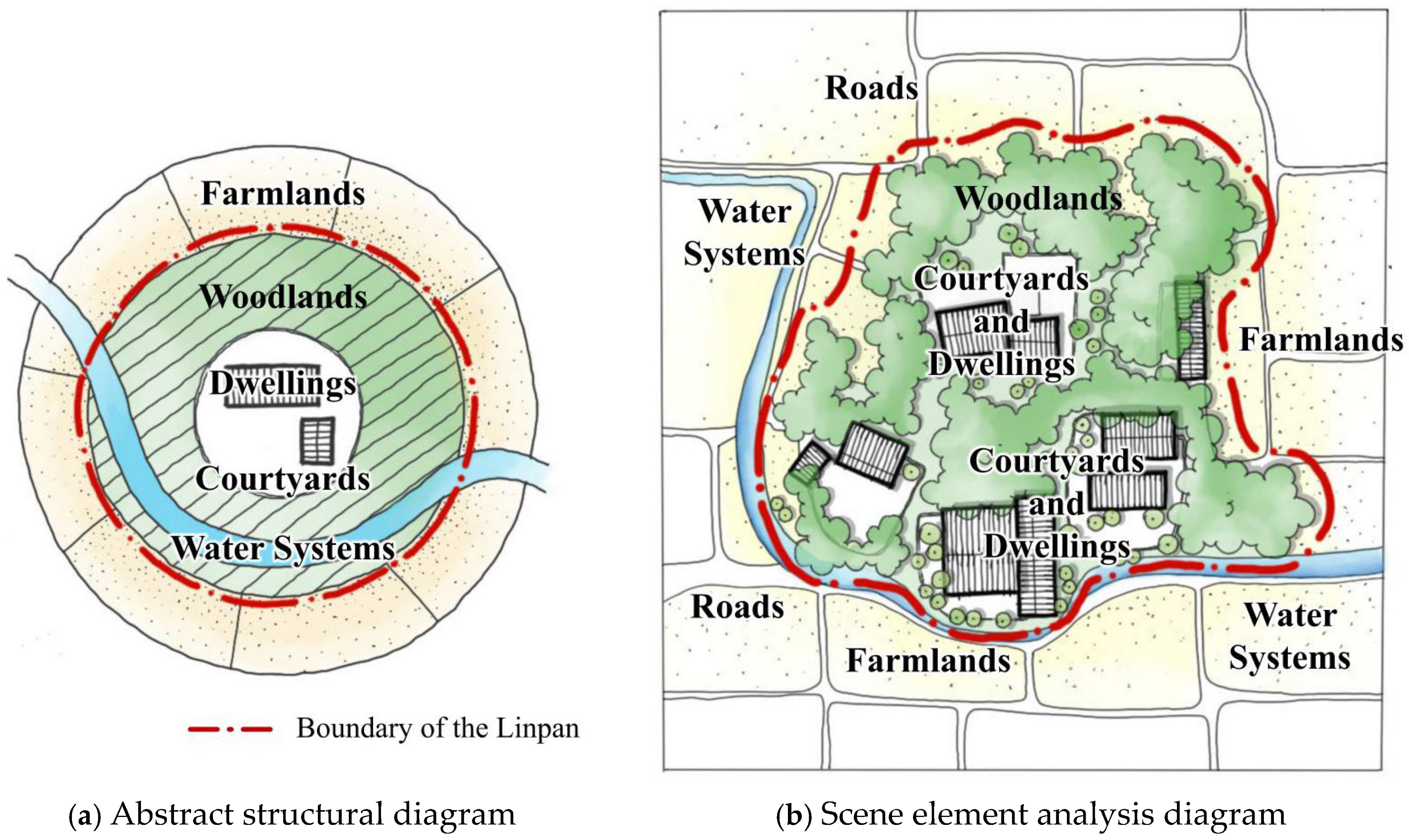
Linpan refers to a distinctive form of rural settlements that emerged in parts of Sichuan Province during the long course of social and historical development. Among them, the Linpans located on the western plains of Chengdu—commonly referred to as Western Sichuan Linpan—represent the most typical examples. As a cultural crystallization of traditional agricultural civilization, the origins of Western Sichuan Linpan can be traced back to the ancient Shu civilization. These settlements gradually formed through successive waves of migration and have endured for thousands of years. Over time, Linpan courtyards have become deeply integrated with their surrounding natural elements, including tall trees, bamboo groves, waterways, and cultivated fields. This integration gave rise to the characteristic spatial structure of Western Sichuan Linpan, with “farmlands, woodlands, water systems, roads, courtyards and dwellings” as its core components (
Figure 1). This settlement structure supported a self-sustaining socio-economic model based on small-scale peasant farming, featuring irrigation agriculture, woodlands-based foraging, and bamboo weaving [
1]. The result is a distinctive rural landscape characterized by “interwoven mountains, water, farmland, and woodlands, with scattered Linpan dotting the terrain”. This configuration reflects not only a production model rooted in self-sufficiency but also an ecological system capable of maintaining its own internal balance. As a dispersed rural settlement system that simultaneously fulfills functions of habitation, production, ecology, and landscape aesthetics, the Western Sichuan Linpan stands as a vivid and enduring embodiment of regional agricultural civilization, folk traditions, and vernacular construction techniques [
2]. Even in the contemporary era, it retains significant ecological, cultural, and socio-economic value.
Linpan not only represents the living heritage of China’s regional agricultural civilization but also embodies the accumulated wisdom of rural residents in production, daily life, and ecological management. However, like many other traditional settlements worldwide, Linpan is increasingly affected by urbanization and currently faces a series of survival challenges, including spatial fragmentation, functional simplification, and cultural dilution. Under the combined pressures of global urbanization and internal social changes, rural regional systems are undergoing a series of adaptive transformations. This raises the question: what forms of adaptive transformation are occurring in traditional villages with respect to spatial structure, social organization, and ecological functions? Although these processes follow diverse trajectories in different regions, they are commonly constrained by the tension between “protection and development” and the “loss of identity and function.” In order to identify the spatio-temporal evolution characteristics of rural settlements, existing studies have yielded substantial research findings in such aspects as regional types [
3,
4], scale and morphology [
5,
6], influencing factors [
7,
8,
9], and functional mechanisms [
10]. Quantitative geospatial analysis based on remote sensing satellite data and GIS technology platforms remains the mainstream approach for rural settlement research [
11,
12,
13,
14,
15,
16,
17], and the research perspectives on the characteristics of rural settlements also generally exhibit distinct regional attributes [
18,
19,
20,
21].
Current research on the spatial evolution of Linpan settlements in western Sichuan primarily advances from three perspectives. First, from the perspective of settlement scale, studies typically employ remote sensing imagery and GIS-based spatial analysis to reveal the size variations and evolutionary trends of Linpan across different historical periods at a macro scale [
22,
23]. However, most of these studies focus on the time span between 2000 and 2020 [
24,
25], and the research scale is generally limited to the county (district) level or below [
26,
27,
28,
29]. Second, from the perspective of regional typology, representative Linpan cases are often selected for analysis—either to examine the current status of landscape components from a conservation viewpoint [
30], to identify and extract the Linpan’s landscape genes [
31], or to analyze changes in specific elements [
32]. These approaches collectively summarize the transformation patterns of Linpan components and categorize their developmental types [
33]. Third, from the perspective of influencing factors, numerous scholars have explored how natural, socio-economic, and historical–cultural factors affect the evolution of Linpan settlements [
34]. While these studies have revealed the correlations among various social drivers and their mechanisms of influence, most remain qualitative in nature.
From a macro perspective, while existing research provides a general overview of the evolutionary trends of Linpan settlements, a fundamental question remains unresolved: are these macro-trends universal across all settlements, or are they localized phenomena driven by specific evolutionary trajectories? In essence, the evolution of Linpan is not a linear, singular path but a multilinear process characterized by diverse coexisting pathways. Relying solely on aggregated statistical data risks obscuring significant typological differentiation under the guise of “average trends,” thereby failing to capture critical insights into evolutionary heterogeneity. From a micro perspective, the morphological transformation of traditional Linpan—the cornerstone of their unique ecological and cultural value—stems from the structural reconfiguration of their internal constituents: “farmlands, woodlands, water systems, roads, courtyards and dwellings.” A purely macro-geographical approach is incapable of capturing these nuanced micro-recomposition processes, let alone revealing the mechanisms underlying the shift in cultural-ecological values. Furthermore, divergent evolutionary paths likely correspond to distinct dominant driving forces. Broadly addressing “evolutionary trends” not only masks heterogeneous types but also fails to elucidate why specific paths emerge and whether they represent adaptive system transformations or terminal decline. This research gap is rooted in the lack of an integrated theoretical framework that bridges macro-trends with micro-typologies and spatial patterns with evolutionary processes. Consequently, a systematic understanding of the diverse evolutionary pathways of West Sichuan Linpan amidst rapid urbanization—specifically regarding internal structural shifts, system states, and their shaping—remains elusive.
Accordingly, this study develops an integrated analytical framework—anchored in Socio-ecological Systems (SES) and Adaptive Cycle theories—to bridge the dimensions of “trends, typologies, elements, and mechanisms.” By taking all Linpan settlements within the administrative boundary of Chengdu as research subjects, the research employs a synergistic macro-micro approach to systematically decipher the evolutionary characteristics and underlying mechanisms of these traditional Linpan settlements. Specifically, at the macro level, the Linpan settlement data for five time periods spanning 1980 to 2020 were systematically collected and extracted for subsequent analysis. The landscape pattern index is applied to analyze the spatial and structural evolution of Linpan patches, which are further integrated using the entropy weight method into three comprehensive indices—Aggregation Synthesis Index (ASI), Scale Synthesis Index (SSI), and Shape Synthesis Index (SPSI). These indices collectively depict the spatiotemporal differentiation patterns of the Linpan system over the past four decades, enabling the deconstruction of specific types of Linpan settlements’ evolution. At the micro level, the study examines the internal element changes in typical cases under the major evolution types to reveal the dynamic processes by which the “farmlands, woodlands, water systems, roads, courtyards and dwellings” composite structure responds to internal and external driving forces. Finally, the driving factors and mechanisms underlying the morphological evolution of western Sichuan Linpan are summarized. This research aims to explore the structural transformation characteristics of western Sichuan Linpan under the background of rapid urbanization, as well as the development challenges faced by its traditional cultural–ecological values. It seeks to provide key empirical evidence from East Asian agricultural regions to inform global research on rural geography, landscape ecology, and sustainable development. This study integrates Socio-ecological Systems (SES) and Adaptive Cycle theories to investigate the evolutionary dynamics of Sichuan Linpan settlements. By establishing a correspondence between macro-trends and evolutionary typologies, the research utilizes these typologies as a conceptual bridge to synthesize macro- and micro-scale analyses. This approach unveils the differentiated configurations of driving forces across various evolutionary paths, ultimately providing a systematic, typology-driven response to the long-term evolutionary processes of the Linpan system.
The findings not only support local conservation and planning efforts but also foster a dialogue between Linpan and other traditional settlement systems worldwide, deepening the understanding of rural system resilience, the modernization of traditional knowledge, and the sustainable management of cultural landscapes.
2. Theoretical Framework Development
As a quintessential Socio-Ecological System (SES), the Sichuan Linpan is characterized by a unique composite structure of “farmlands, woodlands, water systems, roads, courtyards and dwellings.” This configuration is the emergent result of long-term co-evolution and reciprocal interactions between the social subsystem (represented by residents’ production-living modes and institutional norms) and the ecological subsystem (comprising forest land, water bodies, and farmland). Over the past four decades, Linpan settlements have undergone profound transformations involving a series of dynamic processes, including system stability shifts, external shocks, and structural reconfigurations. Consequently, this study integrates SES theory with Adaptive Cycle theory to construct an analytical framework capable of capturing the dynamic “prosperity–decline–reorganization” trajectory. This framework is designed to unveil the evolutionary pathways, the micro-morphological reorganization patterns of internal elements, and the heterogeneous driving mechanisms of the Linpan system.
Drawing upon socio-ecological systems (SES) theory [
35], the interaction between human societies and natural environments constitutes a complex adaptive system characterized by multi-scalar and multi-level feedback loops. This framework identifies four core components: the resource system (e.g., the forests and water bodies within Linpan), resource units (e.g., individual trees or farmland plots), the governance system (e.g., land-use policies and village-level regulations), and users (e.g., local inhabitants and external stakeholders). The interactions and coupling degrees between these components dictate the system’s overall function, stability, and evolutionary trajectory. Consequently, Linpan should not be viewed merely as a static “spatial form” or “settlement type,” but rather as a complex, co-evolving entity where natural elements (forests, water, and fields) are inextricably nested with anthropogenic elements (residences, roads, lifestyles, and governance rules). The profound transformations induced by urbanization are not isolated events; instead, they simultaneously impact the ecological subsystem (e.g., forest fragmentation and water landfill) and the social subsystem (e.g., demographic outflow, livelihood transitions, and land tenure reforms). These impacts are further magnified through cross-system feedback loops. Therefore, deciphering the evolution of Linpan necessitates an integrated investigation into the state shifts in each SES component and the resulting structural adjustments in their coupling relationships.
Adaptive Cycle theory [
36] serves as a cornerstone of resilience science, conceptualizing the dynamic evolution of complex systems through four recursive phases: exploitation (r), conservation (K), release (Ω), and reorganization (α). A pivotal tenet of this theory is its emphasis on systemic adaptability—the capacity of a system to embark on a novel trajectory following release and reorganization, rather than merely “returning to the status quo.” While traditional applications of “reorganization” typically focus on ecological restoration or functional substitution, the evolution of Sichuan Linpan over the past four decades can be effectively interpreted through this dynamic lens.
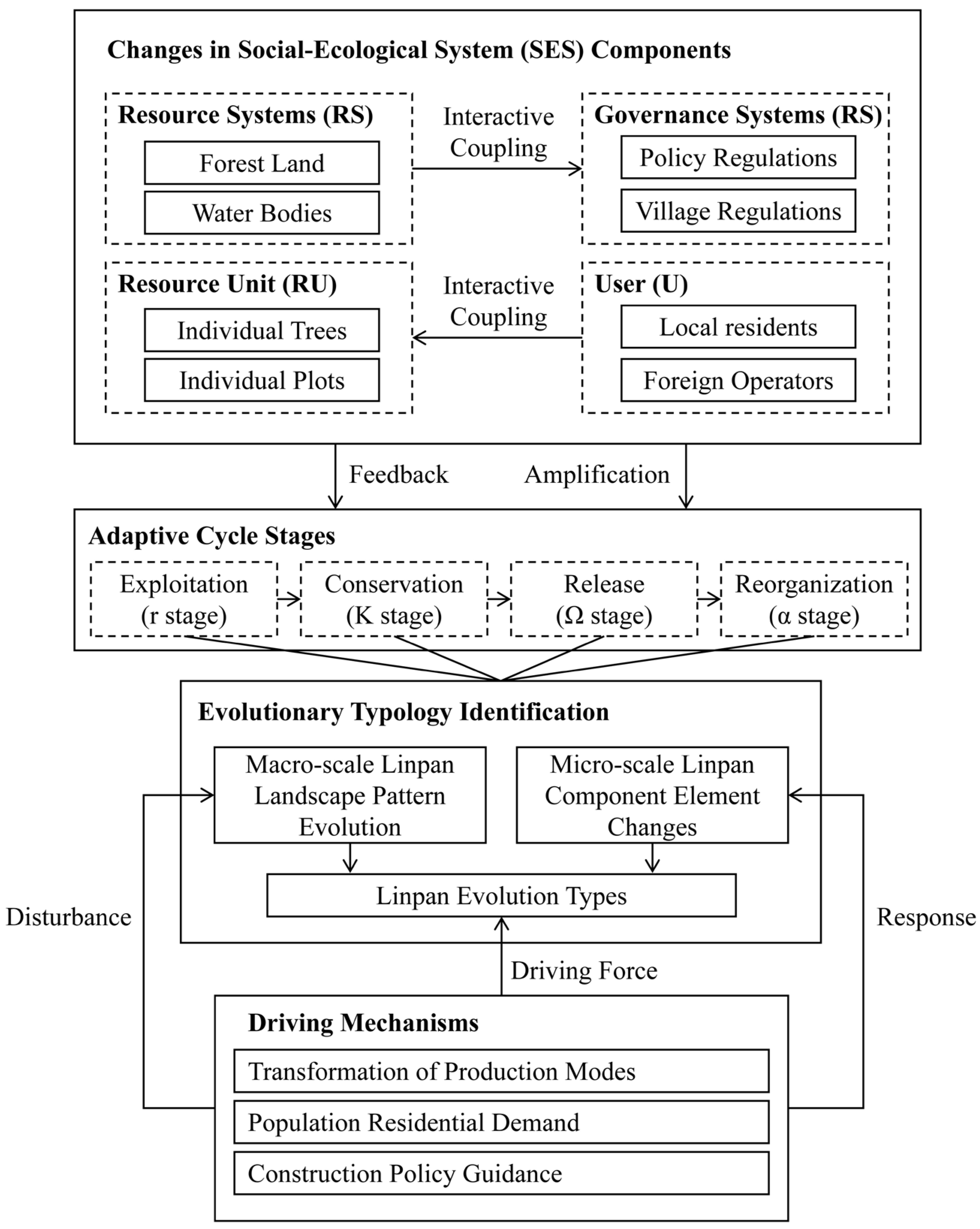
SES and Adaptive Cycle theories provide complementary perspectives—”systemic composition” and “dynamic process,” respectively—for analyzing the evolution of Linpan. Although these theories developed independently, this study integrates and extends them into three key dimensions (
Figure 2):
First, embedding SES components into the stages of the adaptive cycle. The configuration and coupling intensity of Linpan’s SES components exhibit systemic variations across different evolutionary phases. For instance, during the traditional early stage, a highly coupled and stable structure typically forms among the resource system, resource units, users, and governance systems. However, during periods of external shock, disturbances may trigger the decoupling of these components, while the reorganization phase may give rise to novel component configurations.
Second, expanding the connotation of the “reorganization” concept. While traditional Adaptive Cycle theory focuses on ecological restoration or functional substitution during reorganization, this research extends this concept into the socio-spatial dimension. Reorganization in Linpan encompasses not only the biophysical remediation of forests and water bodies but also the comprehensive reconfiguration of residential morphology, spatial structure, economic functions, and social governance. This extension enables the theory to more effectively elucidate the complex transformation of rural settlements under the pressure of urbanization.
Third, establishing a theoretical analytical framework linking “SES state—Cycle stage—Evolutionary typology—Driving mechanism.” The divergent evolutionary outcomes of Linpan stem from variations in the intensity and combination of driving forces across different stages. Specifically, the transition of production modes acts as a “chronic disturbance” that continuously alters resource utilization and user livelihood strategies. Meanwhile, construction policies may serve as “acute interventions,” directly reshaping the allocation of governance and resource systems through institutional design. Furthermore, population residential demands act as both a disturbance and a response, potentially accelerating systemic shifts or providing new structural components (e.g., changing user demographics) for the evolutionary process.
4. Evolutionary Characteristics of the Macro-Scale Linpan Patches
By extracting the land patches of Linpan in Chengdu from 1980 to 2020 and applying landscape pattern metrics, this study analyzes the macro-scale spatial evolution characteristics of Linpan patches within the Chengdu urban administrative region. The overall results are presented in
Table 3.
In general, Linpans have shown patterns of aggregation and consolidation, particularly in suburban areas adjacent to the urban core. Within much of the urbanized area, the total land area occupied by Linpan has expanded, while many smaller Linpan units have been absorbed or have disappeared entirely. The total number of Linpan has decreased over time. Simultaneously, the spatial morphology of Linpan patches has become more compact, and their boundary configurations have grown increasingly complex.
4.1. Aggregation Evolution
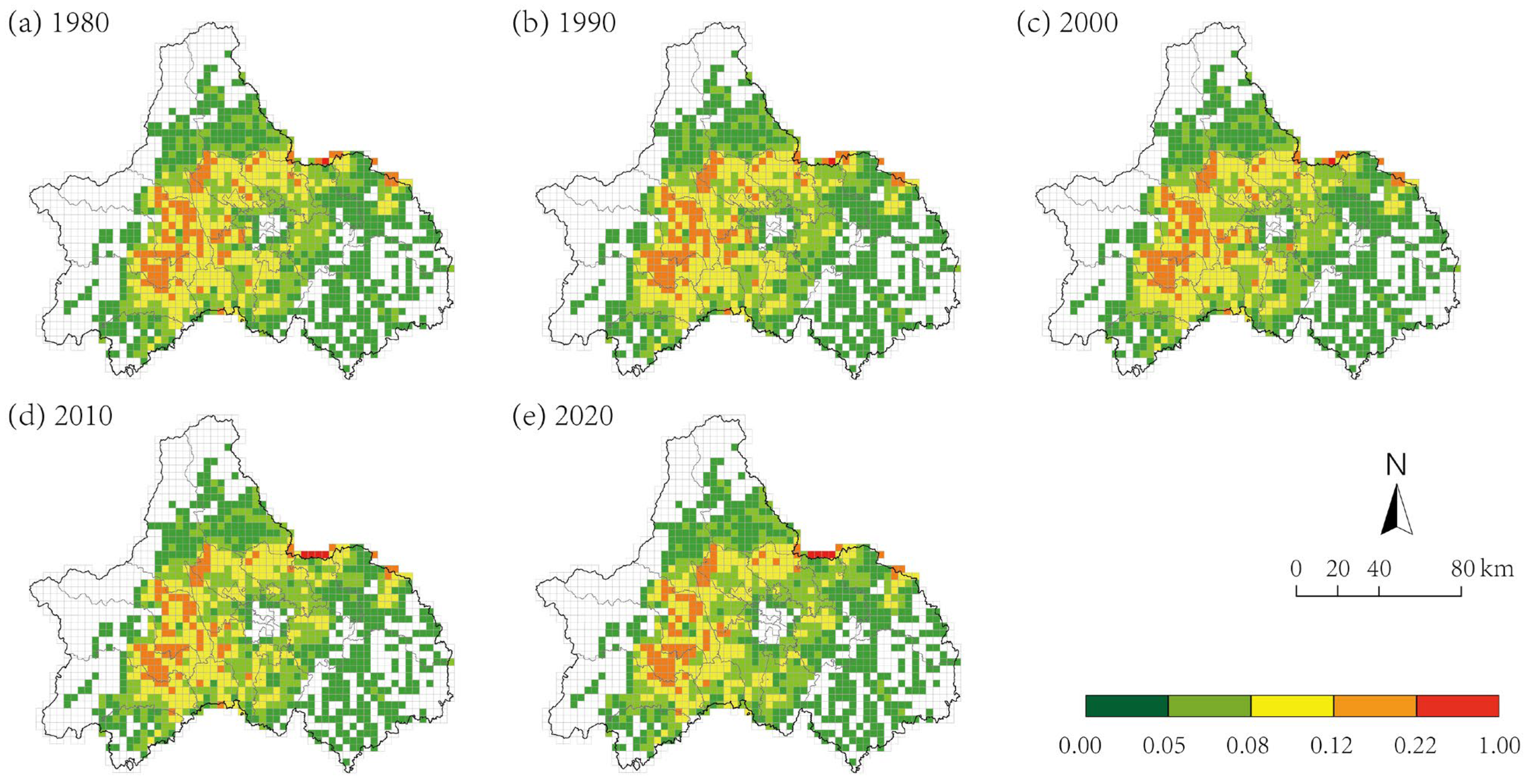
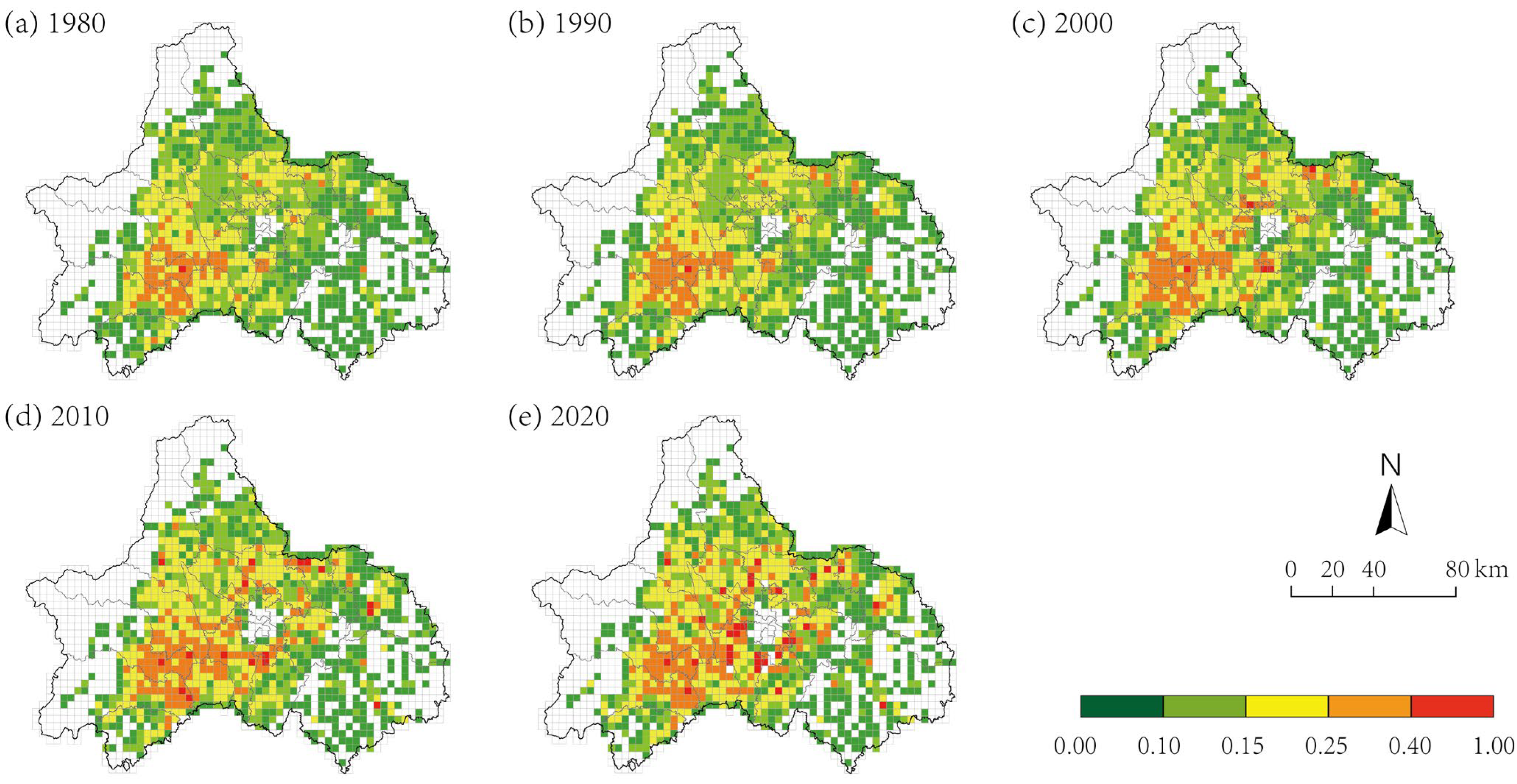
From the perspective of Aggregation Index, the overall Clumpy of Linpan has increased over time, while the Fragmentation Index has gradually declined. In 1980, due to Chengdu’s overall geographical configuration, the spatial distribution of Linpan exhibited a pattern of being dispersed in the central region and concentrated along the peripheries. Settlements in the central plain were relatively evenly and uniformly distributed, whereas those in surrounding mountainous and hilly areas—such as the Longquan Mountain and Longmen Mountain ranges, the Chengdu Eastern New Area, and Jianyang City—tended to cluster more intensively.
In 1990, Linpan largely followed the established spatial pattern, with only minor changes observed. By 2000, although the metrics still showed relatively limited variation, Linpan patches in areas surrounding the urban core began to experience notable integration and consolidation. A significant shift occurred in 2010, with the AI of Linpan increasing markedly compared to the previous periods. This year marked the highest rate of spatial transformation across the 40-year study period, particularly in the northern parts of Shuangliu District, where fragmentation sharply declined and Linpan merging became increasingly prominent.
By 2020, the overall rate of change in aggregation had slowed, yet the spatial clustering trend remained evident, radiating from the urban core of Chengdu and extending southwestward into areas such as Shuangliu District, Xinjin District, and the eastern parts of Qionglai City. In terms of distribution frequency over the 40-year period, approximately 50.5% of the grid units exhibited an increase in Linpan AI by over 0.05, while 34.1% showed a decrease of at least 0.05. More than 60% of the grid units displayed a rising trend in the AI, concurrently accompanied by a pervasive decline in landscape P. Specifically, about 69% of the units recorded a decrease in P within a range of 0.2. Across the entire study area, Linpan settlements have undergone continuous processes of aggregation and merging over the four decades, with the most significant transformation occurring around the year 2010 (
Figure 4).
4.2. Scale Evolution
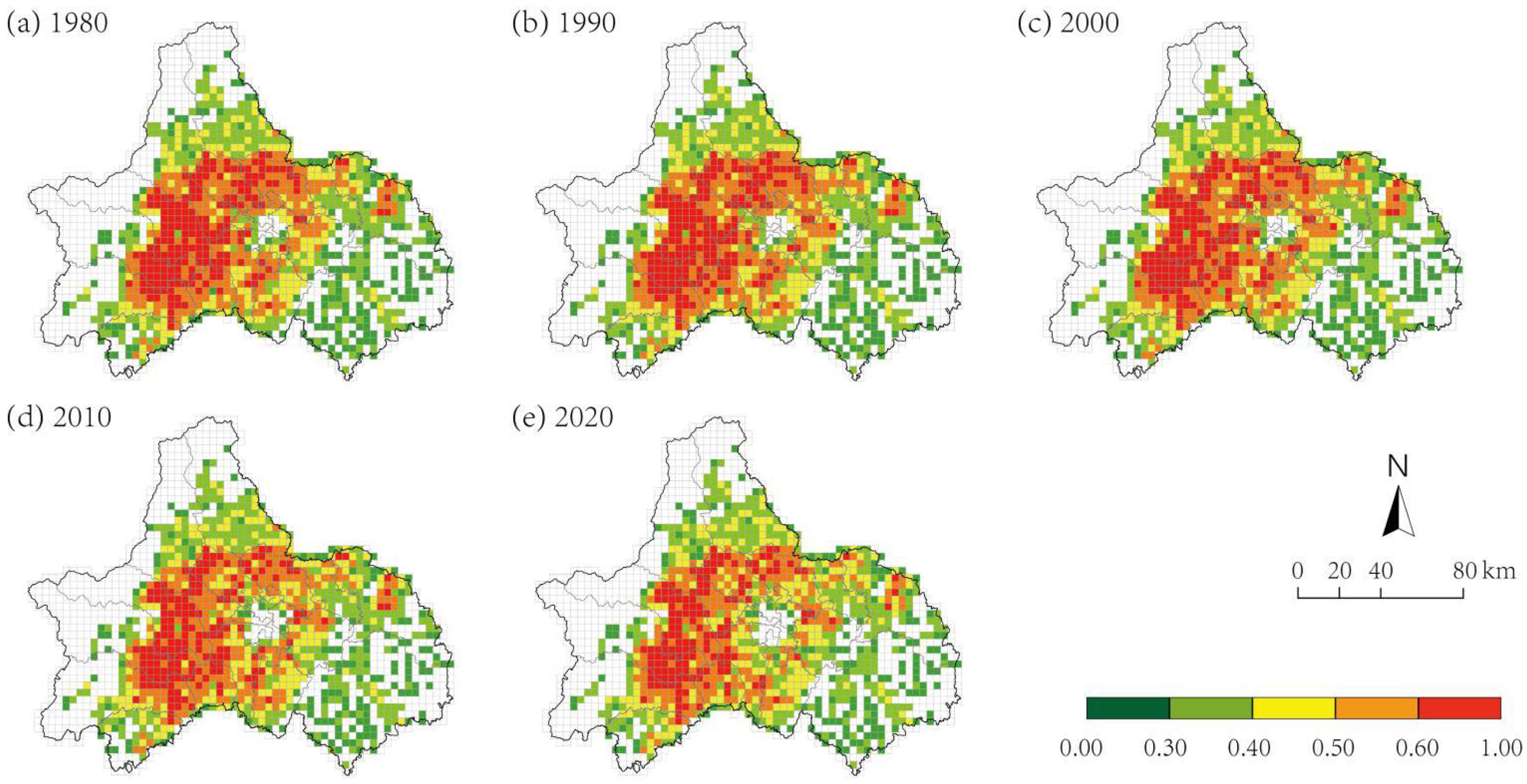
From the perspective of Scale Index, the Class Area and Mean Patch Size of Linpan have generally increased over time, while the Number of Patches and Patch Density of the settlements have significantly declined. In 1980, Linpan were densely distributed across the western plains of Chengdu’s central urban area, with most patches being relatively small in size. By 1990, although the settlements remained widespread in the same region, the overall growth across all Scale Index remained modest.
In 2000, both the total and average CA of Linpan increased by over 10%; however, the NP and PD of settlements showed an initial decline. Despite some growth in the NP in the central-western plains, notable reductions were observed in the Longmen Mountain area, Qingbaijiang District, Jintang County, and Jianyang City. The most significant transformation occurred around 2010, when the NP and CA of Linpan changed most drastically. Extensive declines in settlement numbers were recorded in Qingbaijiang District, Jintang County, the southern parts of Longquanyi District, and the northern region of Jianyang City. Nevertheless, the CA of Linpan continued to grow significantly. By 2020, the overall growth rate of Linpan had slowed; however, the spatial extent of these settlements in the suburban zones surrounding the central city remained on an upward trajectory. This trend was particularly evident in the southern suburban belt, notably in the transitional area between the northern region of Shuangliu District and the urban core, where rapid expansion led to continuous area increases. Many of these new or transformed settlements exhibited MPS far exceeding those of traditional Linpan, frequently reaching 10–15 hectares, and in some cases surpassing 30 hectares.
Over the 40-year period, the NP of Linpan steadily declined, yet the proportion of grid units containing five or fewer settlements remained relatively stable. This suggests that the reduction in settlement count was concentrated in areas that initially had a high PD of Linpan patches. In 1980, approximately 94.36% of Linpan were smaller than 15 hectares (with 44.59% below 5 hectares), whereas by 2020, this proportion dropped to 86.89% (with only 29.20% below 5 hectares), indicating that settlement expansion occurred across nearly all size categories.
Although the rate of expansion decelerated approaching 2020, suburban areas surrounding Chengdu’s central urban core continued to experience strong growth in CA. The NP of Linpan first increased and then decreased, with a clear inflection point occurring around 2000. Most changes in the NP of settlements within grid units fell within the range of ±5. Declines were primarily concentrated in the Longmen Mountain area, Qingbaijiang District, Jintang County, and Jianyang City, accounting for roughly 60% of all reductions. In contrast, the central-western plain region experienced a moderate increase in NP, representing approximately 27% of the total observed changes (
Figure 5).
4.3. Shape Evolution
From the perspective of Shape Index, the Edge Density of Linpan increased progressively over time, but declined somewhat by 2010. The morphological evolution of these settlements exhibited a trend of initially deviating from regular geometric forms—such as squares and circles—followed by a reconvergence toward more compact shapes after 2000. Overall, both the internal composition and boundary complexity of the settlements have shown modest increases.
In 1980, due to the high concentration of Linpan in the western plains of Chengdu, the ED per grid unit was relatively high, and shapes were notably irregular. In contrast, regions along the Longmen and Longquan mountain ranges exhibited lower concentrations of Linpan, with correspondingly lower ED and simpler geometric forms.
By 1990, approximately 48% of Linpan exhibited increased edge complexity, with around 20% experiencing more than a twofold increase in ED. Conversely, 43% of the settlements became less complex, and their morphologies remained relatively random across counties and districts.
In 2000, the ED and morphological expansion of Linpan in the suburban zones and western plains of Chengdu intensified significantly. Approximately 28% of the settlements exhibited the Shape Index that increased by more than 50%, often evolving into forms that diverged further from standard circular or square configurations. Meanwhile, settlements in areas such as Longmen Mountain, Longquan Mountain, Qingbaijiang District, Jintang County, and the northern parts of Jianyang City became more compact, with reduced edge complexity.
In 2010, the areas exhibiting increased ED of Linpan were largely consistent with those observed in the preceding stage. Notably, in the northern parts of Shuangliu District, Pidu District, and Longquanyi District, the settlements experienced more pronounced morphological expansion and variation. In the suburban zones adjacent to Chengdu’s urban core, the Mean Fractal Dimension Index of settlement patches increased significantly, forming concentric spatial layers around the city. This pattern indicates that, during this stage, the morphological composition and peripheral complexity of Linpan became more intricate.
By 2020, the ED index declined for the first time, suggesting a general smoothing and simplification of settlement boundaries. Although the Shape Index also decreased slightly, the change was not pronounced.
Over the entire 40-year period, 72% of the spatial grid units experienced an increase in the boundary complexity of Linpan settlement forms. The transformation of Linpan settlement morphologies exhibits a convergence-to-extension ratio of approximately 4:6, indicating a predominant tendency toward spatial expansion over consolidation. The morphological evolution patterns exhibited distinct regional characteristics:
In the suburban zones of Chengdu’s central urban area, settlements evolved into irregular polygons with relatively straight boundaries;
In the western plains, they transformed into elongated forms with more free-form edges;
Around the Longmen and Longquan mountains, the settlements have progressively evolved toward more compact and consolidated spatial forms (
Figure 6).
4.4. Evolution Types and Characteristics of Linpan
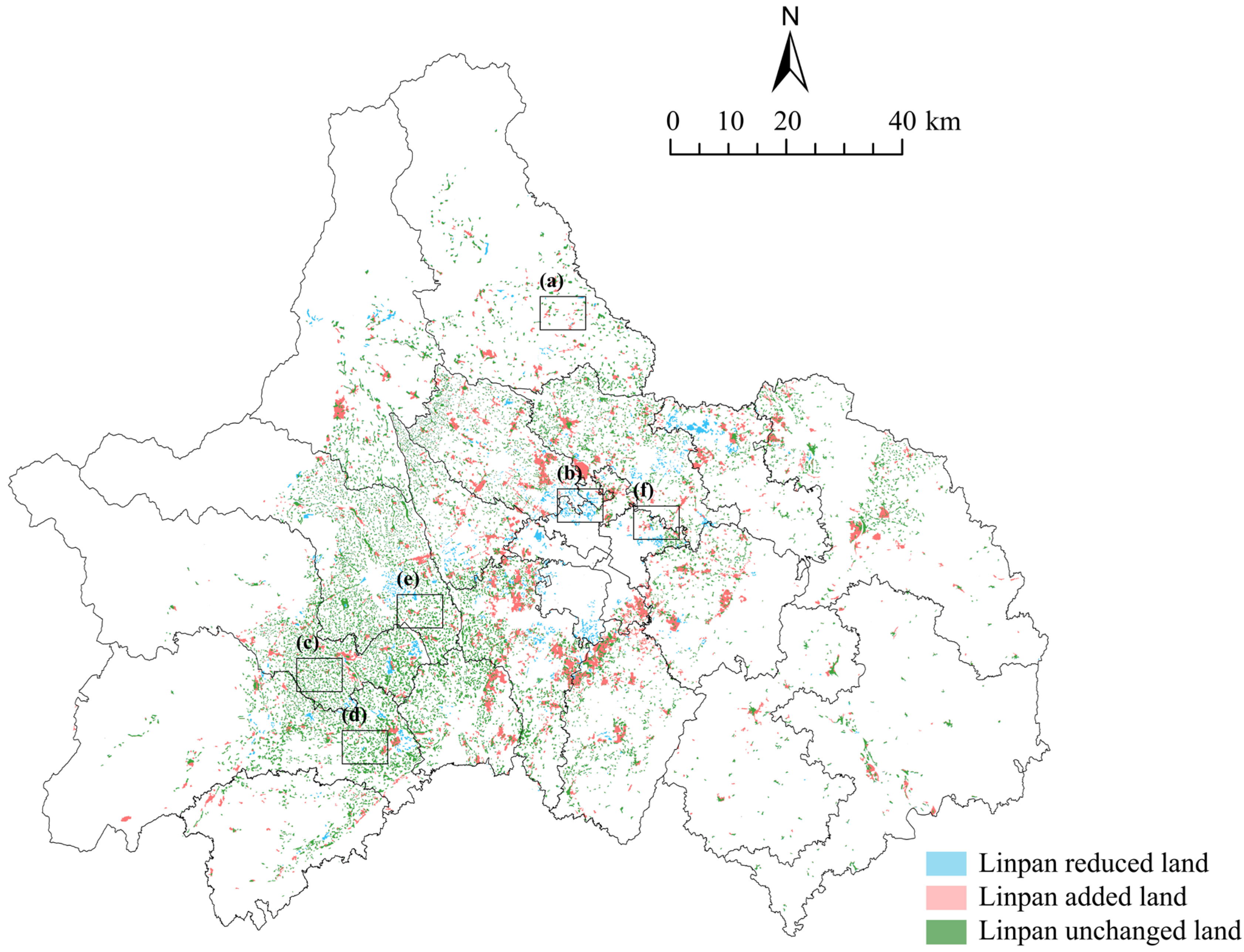
While the aforementioned macro-scale evolutionary trends in aggregation, scale, and shape delineate the general trajectory of the Linpan system, they do not elucidate the specific processes through which these transformations occurred. To bridge this gap, we conducted individual-level trajectory tracking for each Linpan patch by overlaying land-use data from 1980 and 2020, effectively tracing the “fates” of every patch over the four-decade span (
Figure 7). This individual-level tracking reveals that the observed macro-trends—such as increased aggregation, expanded mean patch size, and morphological regularization—were not uniformly driven by all patches. Instead, they resulted from distinct and quantifiable transformation pathways. For instance, the rise in overall aggregation might stem from the merging evolution of adjacent small patches or the relocation evolution of scattered households into newly planned, concentrated residential settlements. Similarly, a reduction in patch numbers could result from direct disappearance (complete removal of the Linpan) or shrinkage evolution (partial loss of spatial extent). Furthermore, the expansion of total construction land can be achieved through in situ transformation (increased density within existing sites), direct addition (establishment of new Linpan on previously undeveloped land), or relocation transformation (replacement of old sites with larger-scale new settlements in different locations). By systematically comparing the geometric morphology, location, and area of each patch before and after the transformation, this study identifies six mutually exclusive and exhaustive transformation types: Direct Addition, Direct Disappearance, In situ Evolution, Shrinkage Evolution, Merging Evolution, and Relocation Evolution.
Direct Addition: A spatial evolutionary process characterized by the emergence of Linpan settlement patches from non-existence. These newly established patches possess a complete, composite Linpan ecological structure, and their occurrence exhibits no direct spatial continuity with the migration or expansion of any pre-existing Linpan.
Direct Disappearance: A spatial evolutionary process representing the complete elimination of Linpan settlement patches. In this mode, the patches remain relatively stable prior to their disappearance, after which the original sites are entirely converted into other land-use categories—such as urban built-up land, transportation infrastructure, or large-scale farmlands. Crucially, no compensatory or alternative patches are established at the original site or within its immediate vicinity.
In situ Evolution: This mode is characterized by long-term spatiotemporal continuity at the original geographic location, albeit with significant incremental changes in boundaries, morphology, or internal structure. Such transformations include moderate expansion of patch area, morphological alterations, or a reduction in internal vacancy rates, while the total number of patches remains constant. This type represents an adaptive evolution achieved through internal renewal and organic growth, serving as a spatial mapping of progressive socio-economic development.
Shrinkage Evolution: A process characterized by the spatial contraction or fragmentation of a large-scale pre-existing Linpan into one or several smaller-scale Linpan. By matching the extents of the newly formed smaller patches with the original site, it is observed that the new boundaries are entirely contained within the original perimeter. This evolutionary mode involves the reduction in settlement land exclusively, with no emergence of newly added land-use area.
Merging Evolution: This mode is defined by the integration of a Linpan settlement with one or more adjacent patches, resulting in a significant, step-wise expansion in scale. By overlaying the extent of the newly formed larger Linpan with the original sites, it is observed that the perimeters of the pre-existing patches are entirely encompassed within the new boundaries. This evolutionary pathway is characterized exclusively by land-use expansion, with no observed reduction in settlement area.
Relocation Evolution: This mode refers to a significant spatial shift in the Linpan in situ during its morphological transformation. By comparing the land-use extents of the new and original patches, this evolutionary process is characterized by both substantial land-use addition and concurrent land-use disappearance. Notably, there is a remarkably low overlap ratio between the spatial footprints of the newly formed Linpan and its predecessor.
Ultimately, these six types constitute the fundamental mechanisms for translating macro-scale statistical trends into concrete spatial processes.
Figure 7.
Schematic diagram of the evolution types of Linpan settlement. Note: The figure shows the overlay of land use data from 1980 and 2020, illustrating the specific changes in each patch over the four decades. Rectangles (
a–
f) represent enlarged views of different Linpan evolutionary types, with detailed descriptions of each type provided in
Table 4.
Figure 7.
Schematic diagram of the evolution types of Linpan settlement. Note: The figure shows the overlay of land use data from 1980 and 2020, illustrating the specific changes in each patch over the four decades. Rectangles (
a–
f) represent enlarged views of different Linpan evolutionary types, with detailed descriptions of each type provided in
Table 4.
Table 4.
Evolution Types and Laws of Linpan.
Table 4.
Evolution Types and Laws of Linpan.
| Type | Classification and Illustration | Quantity (pcs)
and
Proportion (%) | Evolutionary Laws |
|---|
| Direct transformation type | (a) Direct addition | 719 (6.40%) | This type describes the spatial morphological evolution in which Linpan settlement patches emerge from previously non-existent locations. Such settlements are typically established along irrigation ditches and road networks. The newly formed Linpan exhibits diverse spatial configurations: the majority comprise newly developed village clusters dominated by modern housing, generally characterized by relatively linear, orderly, and elongated layouts; a smaller proportion display more organic and irregular spatial forms, characterized by dwellings dispersed within the settlement core and enveloped by surrounding trees. |
(b) Direct disappearance  | 874 (7.78%) | This type describes the spatial morphological evolution in which Linpan settlement patches transition from existence to complete disappearance. Depending on spatial location and influencing factors, the direct disappearance process typically occurs through two distinct transformation pathways. The first involves the conversion of Linpan land into urban construction land, such as urban residential areas, industrial zones, transportation infrastructure, or riverfront green spaces. The second entails the conversion of Linpan land into non-construction uses, such as agricultural or woodlands, whereby both the original tree cover and residential structures are entirely removed. |
| Update evolutionary type | (c) In situ transformation | 4626 (41.17%) | This category of Linpan settlement transformation can be divided into two distinct scenarios. (1) The total area of Linpan settlements remained essentially stable over the 40-year period, with area variation not exceeding ±1%, representing 6.91% of all cases. (2) The Linpan settlements at their original sites underwent slight spatial adjustments, with area variation within ±10%, accounting for 34.27% of the total. |
(d) Shrinkage | 215 (1.91%) | The patch size experiences a continuous or stepwise net reduction, accompanied by internal structural contraction—manifested as the formation of voids or a general decrease in spatial extent. This contraction is not followed by relocation, indicating spatial persistence despite decline. Such a pattern represents the process of settlement shrinkage and degradation induced by ongoing population loss and industrial decline. |
(e) Merger | 1956 (17.41%) | Time-series imagery clearly reveals that the isolation zones separating originally independent small patches progressively diminish and ultimately coalesce into a single, integrated patch. This transformation represents a direct spatial manifestation of reorganization induced by strong external interventions, including rural centralized settlement initiatives and comprehensive land-use consolidation programs. |
(f) Relocation | 2845 (25.32%) | The spatial centroid of the Linpan patches has undergone a distinct shift, signifying the contraction of original patches and the partial overlap of newly formed patches with the former. Typically, the new Linpan patches are established in more favorable locations. In both temporal and spatial dimensions, the relationship between the old and new patches embodies a form of “succession” characterized by decline and regeneration. This transformation typifies spatial displacement, relocation, and reconstruction processes driven by factors such as disaster mitigation, ecological protection, or large-scale planning interventions. |
5. Evolutionary Characteristics of the Micro-Scale Linpan
The Linpans of the western Sichuan region embody the most representative traditional rural living space morphology in Sichuan, with their distinctive spatial structures shaped by the long-term interaction between natural and human environments. Under the pressures of rapid urbanization, modern anthropogenic elements have increasingly intervened in Linpan development, reshaping their internal compositional structure and driving substantial transformations in their spatial form at the macro scale. Over the 40-year period of observed change, Linpans have undergone six distinct evolutionary processes: direct addition, direct disappearance, in situ transformation, shrinkage, merger, and relocation. Among these, direct addition and direct disappearance do not involve internal compositional changes before and after transformation, while shrinkage—accounting for only 1.91% of all transformed Linpan—lacks representativeness. Consequently, this study focuses on three primary types: in situ evolution (41.17%), merger (17.41%), and relocation (25.32%). Through extensive field surveys and resident interviews, we analyze the variations in natural and anthropogenic elements within the Linpan before and after transformation, thereby elucidating the spatial form evolution characteristics and the underlying driving mechanisms of different Linpan evolutionary types in western Sichuan.
5.1. In Situ Evolution Type: Chen Linpan, Huoshiyan Village, Zhengxing Subdistrict, Tianfu New Area
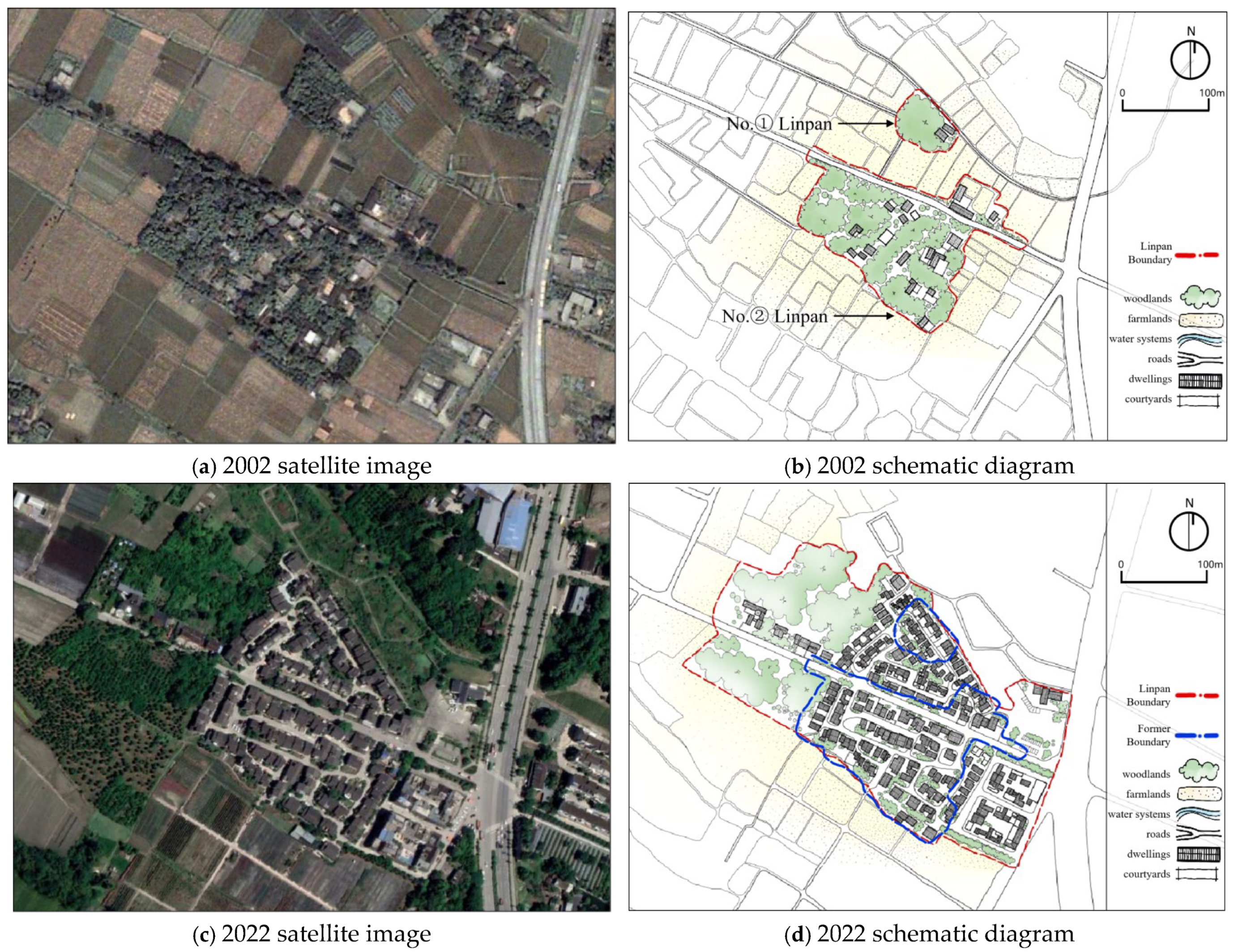
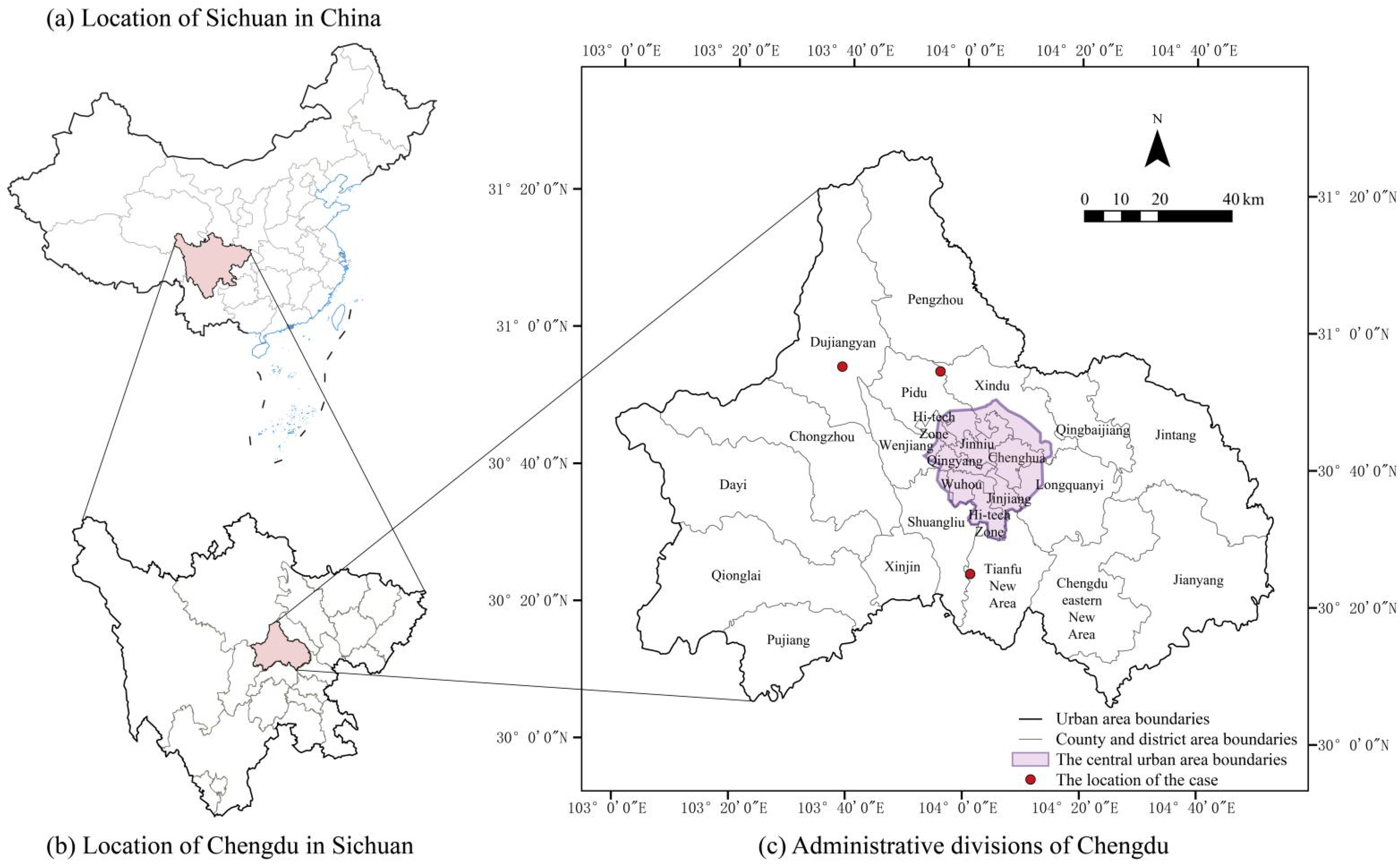
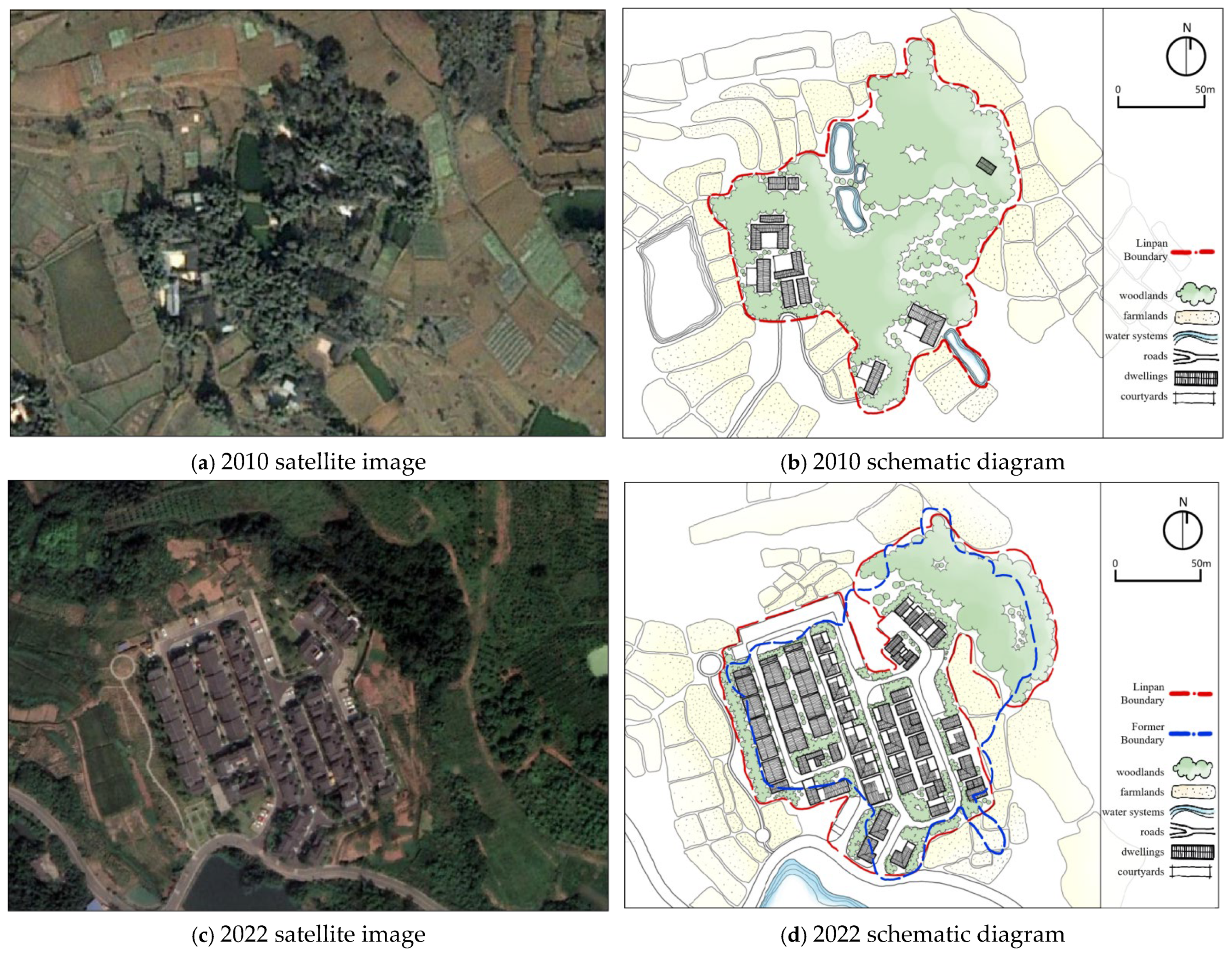
The Chen Linpan in Huoshiyan Village, Zhengxing Subdistrict, Tianfu New Area is approximately 2 km away from the subway station of Line 6 in Chengdu. In March 2019, the Chen Linpan underwent renovation as part of the farmers’ centralized residential zone project in accordance with the “Village Planning of Huoshiyan Village, Zhengxing Subdistrict, Tianfu New Area” and the original map plot rectification project of Huoshiyan Village in Zhengxing Street, Tianfu New Area. It was finally completed in November 2020, accommodating the villagers from Yuanshiyan 6 Group, Shiyan 4 Group, and Dongfeng 6 Group in Huoshiyan Village. It is a typical renovated Linpan for the “model village of rural revitalization” at the district (county) level. The Chen Linpan was renovated based on the original map plot range (
Figure 8). There was no change in the number of Linpan before and after the renovation. Before the renovation, the area of the Linpan was 12,492 m
2, and after the renovation, it was 13,453 m
2, with a total area change of 7.69%. Therefore, the Chen Linpan belongs to the in situ evolution type (
Table 5).
Before the renovation, the Chen Linpan was formed by tall and dense trees and houses interweaving and blending with each other, creating a natural ecological barrier that could prevent wind and reduce dust. The architectural layout was relatively free, mainly concentrated on the south side of the Linpan. Several small ponds were distributed in the middle and edge of the Linpan, which not only facilitated water access for residents but also played a role in regulating the biodiversity and micro-environment climate within the Linpan. After the original site renovation, the number of houses in the Chen Linpan increased significantly by about six times. To accommodate more buildings within the similar Linpan area, the internal layout of the Linpan became compact and regular, with uniform orientations of the houses (
Figure 9). The internal roads were reorganized and connected, forming a continuous traffic system for both pedestrians and vehicles. The boundary of the Linpan was straightly cut by elements such as roads and internal parking lots. Meanwhile, only a part of the northern area of the Linpan retained the unified woodlands planting zone. The originally scattered ponds within the Linpan were all filled in and converted into building land. On the outside of the Linpan, a larger pond was newly built at a different location. The random architectural layout, clustered woodlands barriers, and natural water system texture of the traditional Linpan were not continued during the renovation and evolution process of the Linpan.
5.2. Merger Type: Ma Linpan, Zhilu Village, Gucheng Town, Pidu District
The Ma Linpan, located in Zhilu Village, Gucheng Town, Pidu District, lies approximately 14 km from the central urban area of Chengdu. Zhilu Village currently hosts five resettlement communities
3, among which Ma functions as one of the primary resettlement areas, accommodating residents relocated from the former 8th to 11th community groups of the village. In 2015, the bamboo birdcage-making craft of Gucheng Town was inscribed on the provincial intangible cultural heritage list. Subsequently, Linpan in Gucheng Town underwent re-planning, renovation, and expansion (
Figure 10).
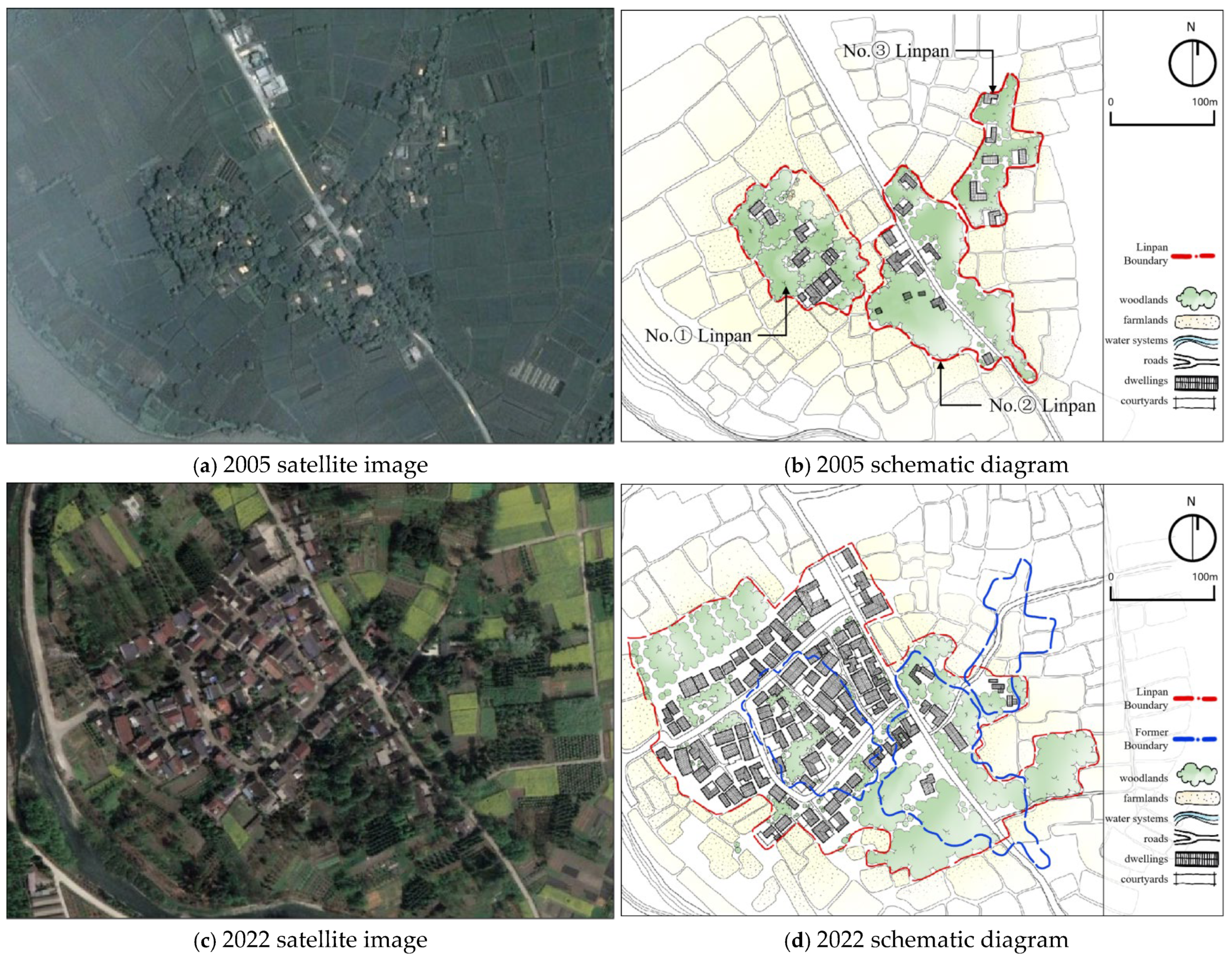
The first phase of renovation for the Ma Linpan focused exclusively on the larger southern section (i.e., the No. ① Linpan in
Figure 10). In 2019, building upon the cultural and spatial resources of Gucheng Town, the “Source of Shu Prefecture: Western Sichuan Linpan—Selected Works from Cultural Exhibition Bamboo Studio” Demonstration Project for Zhilu Village was launched to promote heritage preservation and rural revitalization. Ma Linpan was designated as one of the eight municipal-level rural revitalization demonstration villages in Pidu District. The second phase of renovation extended to the northern side of Tanggu Road
4, incorporating and integrating the smaller northern Linpan (i.e., the No. ② Linpan in
Figure 10).
Through these two phases, two previously dispersed and independent Linpan were consolidated into a single, larger settlement unit. The combined area expanded from 30,511 m
2 prior to renovation to 87,210 m
2 afterward, representing an increase of 185.83% (
Table 6). As the expanded Linpan fully encompassed the footprints of the two original settlements without any land reduction or expropriation, the Ma Linpan exemplifies the merger and evolution type in settlement transformation.
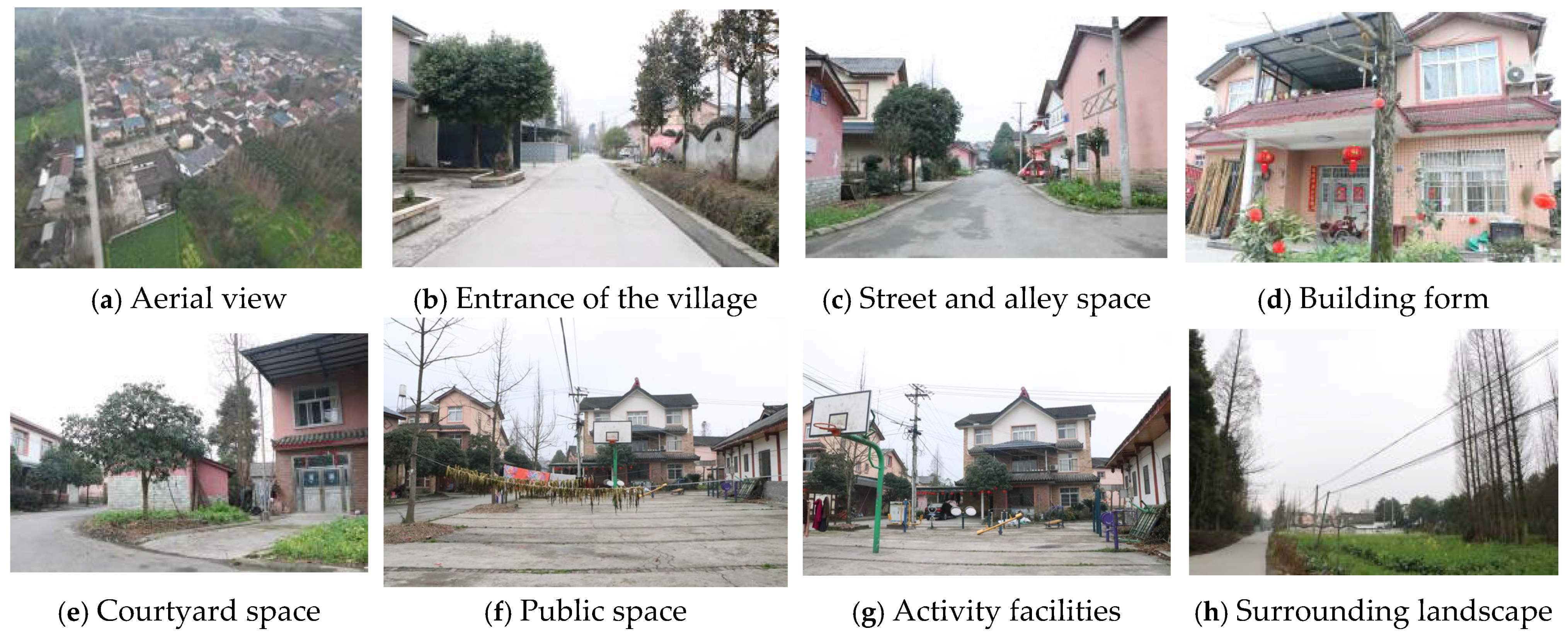
Before the renovation, the Ma Linpan was situated along Tanggu Road, a secondary route situated at some distance from the primary thoroughfare, Pipeng Road. Trees were planted along the periphery of the courtyard space, interwoven with the buildings, creating a spacious setting suitable for the traditional craft of bird cage production. The architectural style followed that of rural dwellings, characterized by a simple yet generous appearance, with most buildings featuring 1–2 story pitched roofs.
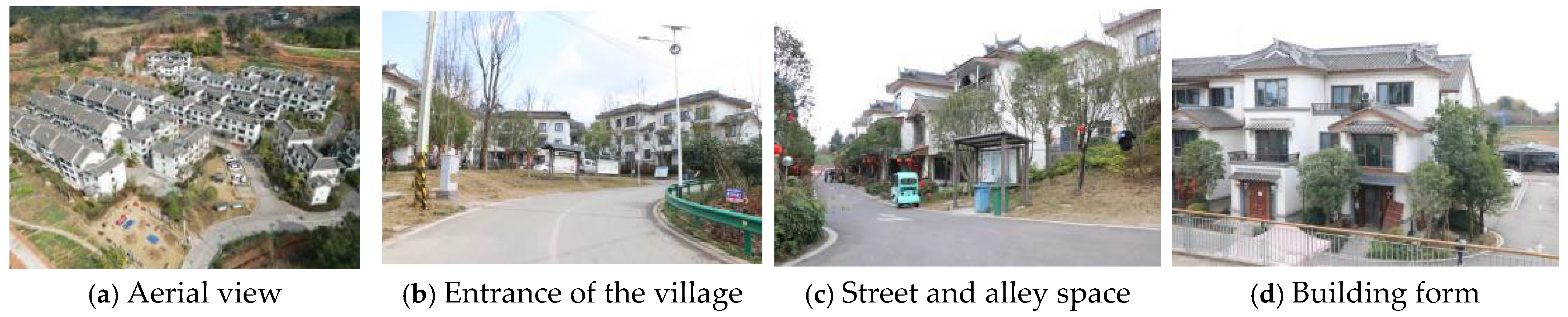
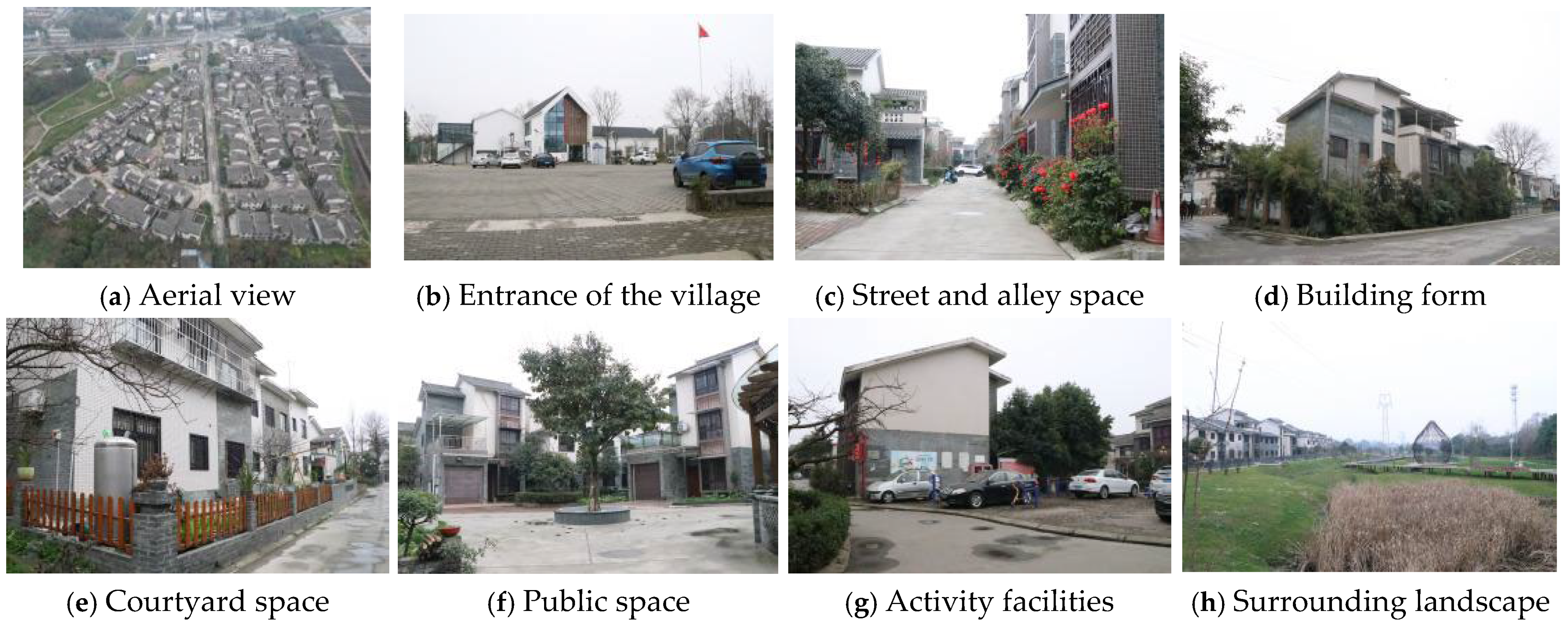
Following the merger and expansion, the Ma Linpan increased substantially in scale, extending eastward toward Pipeng Road and westward beyond its original boundaries. The number of houses increased by approximately 14-fold, and the building layout adopted a straight, orderly configuration. The internal circulation system was organized in a cross-shaped pattern, with some residences equipped with unified parking areas. Public facilities—including communal buildings, parking lots, and squares—were positioned near the village entrance (
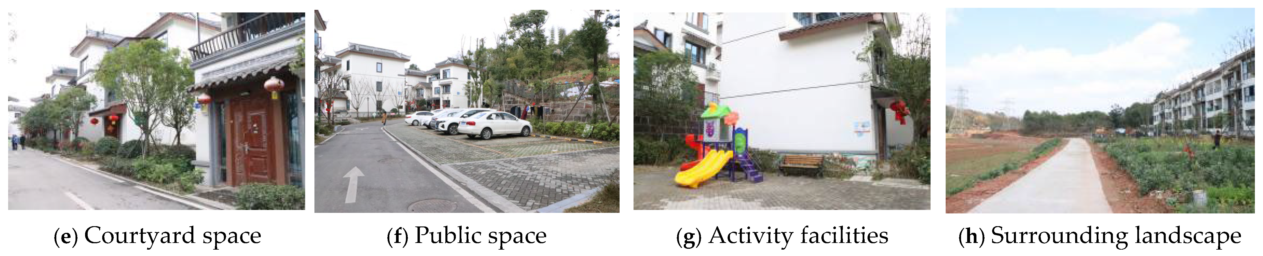
Figure 11).
While certain courtyard spaces were retained, their size was markedly reduced. The renovated Linpan featured uniformly shaped, stand-alone buildings constructed with modern materials such as cement and steel pipes, which were unable to replicate the original rural texture. Furthermore, the newly designated cultural tourism land associated with the bird cage industry was spatially disconnected from the everyday living environment of local residents.
5.3. Relocation Type: Qiu Linpan, Yongxing Village, Mount Qingcheng Town, Dujiangyan City
The Qiu Linpan in Yongxing Village, Mount Qingcheng Town, Dujiangyan City, is located approximately 33 km from Chengdu. The settlement is bounded by a village-level road to the east and the Jinma River to the west. In 2013, as part of Mount Qingcheng Town’s “Comprehensive Management of Dispersed Residential Areas” initiative, the Qiu Linpan underwent expansion and reconstruction, with the project completed in 2014. Yongxing Village comprises 11 villager groups, among which the renovated Qiu Linpan is the sole farmer-concentrated residential area to have been upgraded. The renovation markedly increased the scale of the settlement (
Figure 12): prior to intervention, the three constituents of Linpan occupied a combined area of 25,928 m
2. Post-renovation, the three were consolidated into a single, larger Linpan concentrated constructed on a newly selected site, covering 64,991 m
2. The new site primarily encompassed the original locations of the No. ① and No. ② Linpan, while much of the land from the No. ③ Linpan was vacated for other uses. This transformation resulted in a net addition of 42,532 m
2 (an increase of 164.04%) and a decrease of 3469 m
2 (a reduction of 13.38%) (
Table 7). Based on these changes, the Qiu Linpan is classified as a relocation evolutionary type settlement.
Before renovation, the internal circulation of the Qiu Linpan was defined by organically formed footpaths, shaped by the daily production and social activities of residents. These narrow routes, typically 1–2 m wide, were primarily used by pedestrians and tricycles, and were interwoven with tall trees throughout the settlement. The area maintained a relatively enclosed character, with a flexible and irregular residential layout. Courtyard configurations—predominantly open or enclosed—served as multifunctional spaces, facilitating grain drying, handicraft production, and hosting community banquets or recreational activities.
Following relocation and reconstruction, the Linpan expanded substantially, extending westward toward the river and eastward toward the road. Internal roads were redesigned in the form of loop lanes, similar to those in modern urban residential communities, to accommodate vehicular traffic. At the entrance, a unified public activity plaza and parking facilities were introduced. To optimize land use, traditional courtyard spaces were largely eliminated, with household entrances opening directly onto internal roads. The rebuilt settlement exhibits a compact spatial structure, with uniformly planted trees arranged in concentrated rows. The present configuration of the Linpan contrasts markedly with its traditional form, resulting in a substantially altered living environment. Historically, residential spaces were compactly arranged, with varying building heights subtly integrated into the surrounding woodlands and farmlands, creating a harmonious and aesthetically pleasing rural landscape in which “houses were interconnected.” In the current configuration, the spatial arrangement of dwellings has been restructured, leading to a distinctly different settlement morphology and living environment (
Figure 13).
6. Analysis of the Evolution Mechanism of Linpan in Western Sichuan
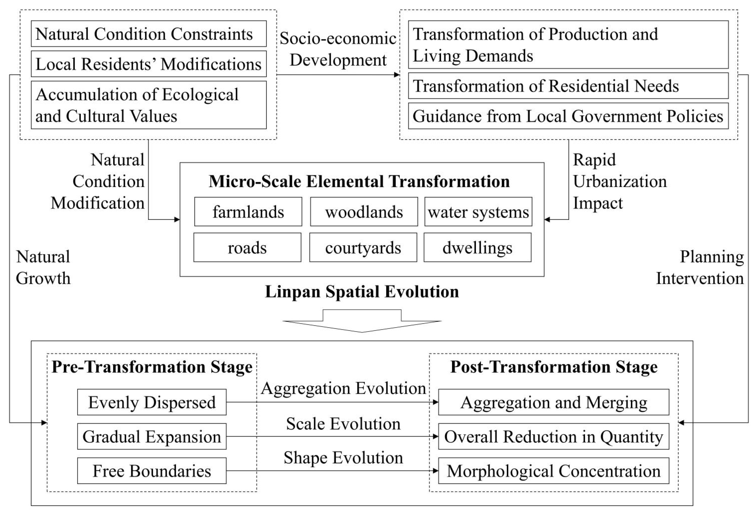
The Linpan of western Sichuan emerged through a gradual process of natural growth, shaped by the constraints of local environmental conditions. Over time, local residents actively reconfigured the internal elements of these settlements, giving rise to a distinctive spatial morphology that embodies substantial ecological and cultural value. At this point, the system manifests as a stable and highly coupled socio-ecological structure characteristic of the K-stage. With societal transformation, residents’ production and living demands have evolved, triggering the Ω-stage, characterized by landscape fragmentation, population out-migration, and ecological degradation. Subsequently, driven by the dual pressures of rapid urbanization and robust policy interventions from local governments, the human settlements are propelled into the α-stage, where combinations of novel components emerge. It is noteworthy that this Linpan reorganization during the α-stage is not the consequence of a single isolated driver, but results from the complex interplay of three forces: the transformation of production methods, population migration, and policy-oriented construction guidance (
Figure 14). This section adopts the lens of the Adaptive Cycle to conduct an in-depth analysis of how these triple driving forces interplay with one another and ultimately shape the morphological transformation of the Linpan at both macro and micro scales.
6.1. Shifts in Settlement Aggregation Driven by Evolving Production and Living Demands
The transformation of production methods serves as the fundamental driving force underlying the evolution of the Linpan system. As a crystallization of agricultural civilization in western Sichuan, the Sichuan Western Linpans represent not only a distinctive traditional rural settlement pattern but also serve multiple functions, including maintaining ecological balance, supporting industrial development, preserving cultural heritage, and sustaining local identity. The region’s predominantly flat terrain, fertile alluvial soils, pleasant subtropical humid climate, and abundant woodlands and water resources have fostered the dispersed settlement pattern characteristic of these Linpan. These natural endowments also nurtured a small-scale peasant economy featuring a self-sustaining socio-economic cycle, exemplified by irrigated agriculture, woodland product gathering, and bamboo weaving [
45]. This system underpinned both production self-sufficiency and the autonomous maintenance of the local ecological environment. Furthermore, waterways historically functioned as the primary transportation network, with traditional villagers relying on walking, boats, and draft animals such as oxen or horses to meet the needs of agricultural production, daily travel, and trade. Therefore, traditional Linpan was fundamentally organized around a small-scale agricultural economy characterized by the integration of farming and residence. Its relatively uniform distribution pattern—“scattered along the fields”—represented a spatial adaptation to intensive farming practices such as rice cultivation. This pattern ultimately gave rise to the dispersed and small-scale spatial structure typical of the western Sichuan Plain.
With the maturation of the modern highway network, the widespread adoption of contemporary transportation modes, and the concentration of infrastructure along road corridors, traffic conditions in the region have been markedly improved. Roads have consequently emerged as a new determinant influencing the spatial distribution of Linpan. Unlike the historically self-contained, agriculture-based economic model, enhanced transport connectivity has expanded the channels of interaction between modern Linpans and the external environment, thereby transforming their operational dynamics. Many Linpan have diversified beyond primary agricultural production [
46], adopting mixed economic models that integrate secondary and tertiary sectors, and in some cases relying heavily on engagement with visiting tourists. In such instances, the economic function of Linpan has shifted toward a tourism-driven development paradigm. These factors have fundamentally reshaped the industrial logic and locational value of the Linpan. The Linpan has detached from the closed, self-sufficient agricultural circulation system and become integrated into a broader regional economic network. The “non-agriculturalization” of the industrial structure has enabled many Linpan to break free from absolute dependence on farmland, such that their spatial distribution is no longer constrained to the centers of cultivated fields. The emerging logic of “location selection for benefit” has driven strategic adjustments in the spatial form of the Linpan: settlements have increasingly shifted and clustered toward development resource corridors such as roads and urban areas. Consequently, their spatial configuration has transformed from enclosed, clustered forms to elongated, “finger-like” or “strip-like” structures along transportation axes to maximize economic advantages.
From the perspective of the Adaptive Cycle, this spatial logic transition from “water-network-oriented” to “road-network-oriented” serves as a critical signal of the system’s transition from the K-stage to the α-stage. During the K-stage, the spatial distribution of Linpan was locked by stable agricultural production radii, manifesting as an “evenly dispersed in fields” pattern. As the transformation of production modes (e.g., agricultural industrialization, tourism development) becomes a chronic disturbance, the original spatial-production coupling begins to loosen, pushing the system into a transitional state of release. The refinement of road networks subsequently provides new anchors for reorganization—Linpan begin to cluster along roadsides, forming new “finger-like” or “belt-like” morphologies. This process exemplifies a vital characteristic of α-stage reorganization: it is not a stochastic occurrence but a spatial reconfiguration centered around new resource corridors (roads) and locational advantages (proximity to urban areas). While the shift in production modes is the fundamental driver for the spatial re-aggregation, the transition from homogeneity to heterogeneity, and the evolution of morphology from organic to extended, it must be emphasized that this reorganization is more than a mere shift in location. It represents the spatial projection of the Linpan’s economic functional transition from self-sufficient peasantry to market-oriented and tourism-driven economies.
6.2. Scale Transformation Driven by Shifts in Population and Housing Demand
Population dynamics represent the direct driving force governing the scale transformation of Linpan, while these transformations are jointly modulated by shifts in production methods and policy interventions in rural construction. Benefiting from favorable topographic and hydrological conditions, the region has long possessed extensive and fertile farmland resources. To reduce travel time for agricultural activities, early settlers often chose to reside within or adjacent to cultivated fields. This proximity-based settlement habit fostered a balanced spatial layout, typically characterized by a farming radius of 100–200 m and a cultivated area of 50–150 mu. Consequently, Linpan in western Sichuan developed a distinctive spatial pattern described as “scattered dwellings interspersed with farmland.”
In traditional agricultural societies, with natural population growth, land adjacent to existing Linpan was typically already occupied by production activities. In the early stages, newly established Linpan were often deliberately located at a certain distance from the original settlement, appropriating surrounding farmland as new agricultural production areas. This “leapfrog” siting strategy helped avoid competition for arable land between Lipnan. During this period, most Linpan comprised only a few to several dozen households, occupying areas from a few to several tens of mu. The traditional growth model of Linpan was relatively closed and restrained [
47], characterized by slow amount increase and a balanced, dispersed spatial distribution. Consequently, the Linpan settlements in western Sichuan display a distinctive spatial configuration marked by dispersed settlements distributed around agricultural fields.
However, the transformation of the urban–rural dual structure, together with the expansion of non-agricultural employment opportunities, has resulted in a structural shift within the rural population: Following the comprehensive implementation of the household land contract system in 1978 [
48], farmers’ enthusiasm for reclaiming wasteland and residing near their fields increased significantly, leading to a rapid expansion in the number of Linpan. However, as economic and social development accelerated, on the one hand, the availability of new cultivated land became increasingly constrained; on the other hand, a significant outflow of rural laborers to urban areas has led to population decline in many remote villages, resulting in rapid shrinkage or even “hollowing out.” Consequently, the remaining population exhibits a growing tendency to cluster within more developed settlements, seeking access to enhanced public services and broader development opportunities. As a core manifestation of the release stage (Ω), population out-migration signifies the rapid loss of the system’s social subsystem (users). This loss leaves numerous small-scale Linpan without maintenance subjects, leading to the disintegration of spatial structures and an imbalance in the proportion of woodland to built-up areas. Rather than a linear or gradual decline, this release represents a systemic collapse with catastrophic characteristics—within a single decade, many Linpan transformed from inhabited settlements into abandoned “hollow villages” or even disappeared entirely. Paradoxically, it is this intense release process that necessitates and creates the window for subsequent policy interventions and systemic reorganization.
After 2000, with rural construction formally incorporated into the legal system, the promotion of living environment surveys, clarification of village land classification and zoning
5, land system reforms
6, and the strengthening of territorial spatial planning controls, population redistribution has been rapidly intensified as a result of the implementation of targeted policy measures. Meanwhile, disorderly and illegal rural construction was effectively curbed. In western Sichuan, residents of small and medium-sized Linpan were relocated to larger Linpan residential areas, central villages, or newly developed centralized farmer housing communities. The vacated Linpan sites were reclaimed as farmland or woodland, resulting in a polarization pattern characterized by a decrease in cluster numbers and an expansion of their scale. Accordingly, shifts in the population’s housing requirements served as the primary driver of cluster size adjustments. Under the guidance of relevant policy interventions, the system is steered into the reorganization stage (α), marking a fundamental shift in the scale and structure of Linpan settlements. During this phase, the spatial distribution of Linpan transitions from dispersion toward concentration, while their scale evolves from small units into large-scale clusters. Concurrently, the social composition undergoes a transformation from a homogenous structure of indigenous farmers to a diverse user base, encompassing returning populations, new villagers, and external entrepreneurs. It is noteworthy that this scale reorganization extends beyond changes in spatial scale; it is intrinsically accompanied by the reconfiguration of social networks and the transformation of governance demands.
6.3. Morphological Transformation Driven by Policy-Oriented Shifts in Construction
Construction policies constitute the most significant and rapid external drivers influencing the morphological evolution of Linpan. By means of land administration, planning regulations, and project financing, these policies directly shape both the spatial layout and the internal structural composition of the Linpan. In the stage of natural evolution, the interior of the original Linpan settlements interweaves organically with surrounding trees, creating a softly contoured boundary defined primarily by the edges of the tree canopy. Courtyard spaces are dispersed beneath this vegetative cover, forming a spatial pattern closely integrated with the natural environment. With ongoing social and economic development, rural road networks expanded into previously isolated areas, prompting a shift in Linpan morphology from inward-oriented growth to outward extension toward resource nodes such as roads, urban centers, and industrial zones. As these accessible and interactive resource points were developed, the spatial form of Linpan gradually expanded and evolved into irregular natural-boundary polygons, such as the earlier circular or square layouts. During this stage, however, the transformation was largely organic, characterized by low development efficiency and limited visible impact.
Subsequent policy interventions accelerated morphological change. The introduction of the “Three Concentrations
7” policy in 2003, the land reform initiatives launched by local governments in Chengdu around 2006 (including “Land Consolidation” and “Addition and Subtraction of Land Holdings
8”), and post-2008 measures such as “Post-Disaster Reconstruction
9” and the “‘Three Land
10’ Pilot Reform” collectively reshaped settlement patterns. Strategies such as the Rural Residential Land Consolidation, Homestead Withdrawal and Resettlement substantially hastened the processes of Linpan reconstruction and morphological restructuring.
Compared with the slow, spontaneous internal growth pattern and the free, organic spatial form of traditional Linpan, the newly established Linpan communities display multiple construction patterns: First, the form is regularized, through unified planning and construction or unified planning with self-construction, row houses and villagers’ apartment buildings are predominantly arranged in row-style, cluster-style, or peripheral configurations. The building layout is compact and orderly within the designated construction land, displaying strong human intervention and a modern aesthetic characterized by “contemporary single-family houses + artificial or cultivated gardens + extensive road hardening.” Second, the spatial structure is organized. From meeting agricultural production to accommodate contemporary living and consumption needs (e.g., tourism), modern facilities such as parking lots, squares, and public buildings are incorporated within the Linpan, leading to corresponding adjustments in the spatial layout. Third, the elements are segregated. Historical records of large traditional courtyards in Chengdu
11 indicate that, in traditional Linpan, woodland growth and house expansion occurred simultaneously, maintaining a dynamic balance with a land area ratio of at least 3:1 [
49]. As the built area expanded, bamboo woodlands were also maintained and enlarged, maximizing ecological benefits and embodying the wisdom of the ancient settlement design.
Case studies of modernization Linpan reveal that woodlands are now concentrated along the periphery, with only scattered ornamental landscape vegetation within the residential area. The ratio of surrounding woodlands to newly constructed housing is approximately 1:1, and the internal ecological spatial pattern is marked by “vegetation mosaicization” and “habitat fragmentation.” These shifts in the proportion and spatial configuration of internal elements have reshaped the settlement morphology, reflecting the broader transformation of economic and social activities in Linpan under contemporary development conditions. Policy intervention acts as an external guide within the system, directly propelling the transition from the release stage (Ω) to the reorganization stage (α). Distinguishable from the passive responses associated with the transformation of production modes and population migration, policy intervention represents a “proactive intervention.” By implementing standardized construction methods, these policies affect rapid and profound restructuring of physical space, resulting in fundamental modifications to settlement boundaries, internal structures, and inter-element relationships.
7. Conclusions and Discussion
7.1. Conclusions
Unlike rural settlements in other regions, the Linpan of western Sichuan is composed of farmland, trees, water systems, roads, and houses, forming a distinctive spatial structure. By integrating Social-Ecological System (SES) theory with the Adaptive Cycle framework, this study constructs a novel analytical approach that bridges macro-scale patterns with micro-scale processes. Utilizing multi-temporal remote sensing data, landscape pattern indices, and field surveys, we systematically analyzed the spatio-temporal evolution of West Sichuan Linpan from 1980 to 2020. Compared with conventional methods that rely solely on landscape indices to analyze rural settlement patches at a macro scale, this research characterizes the transformations of internal components within Linpan at a micro level. This approach attempts to elucidate the specific mechanisms underlying the spatial evolution of Linpan patches observed from a holistic macro perspective, thereby identifying the unique driving factors and operative mechanisms of the Linpan system. The primary conclusions are as follows:
(1) At the macro scale, the spatial patterns of Linpan are characterized by an overall reduction in total quantity, increased concentration in distribution, and regularization of morphology. Over the past four decades, Linpans have undergone a distinct transition from a pattern characterized by small scales, wide dispersal, and irregular shapes toward a more centralized, agglomerated, and standardized spatial layout. Due to the continuous expansion and radiating influence of Chengdu’s central urban area over these forty years, the evolutionary trends of Linpan in the urban periphery have been particularly rapid and transformative. The degree of Linpan clustering has consistently increased, while the number of patches has decreased, leading to a significant increase in the mean patch area. The complexity of patch shapes initially increased but began to simplify after 2010, reflecting the intensifying impact of anthropogenic activities. However, these macro-trends obscure the significant heterogeneities existing among diverse transformation pathways.
(2) At the micro scale, the evolution of Linpan settlements exhibits diverse typologies; however, a universal trend is the linear extension of Linpan morphology along road networks, accompanied by a significant shift in the proportions of internal components. By tracing the developmental trajectories of various Linpan units, we identified six distinct evolutionary types. Detailed analysis of representative cases reveals a profound transformation in internal configurations: woodland coverage has decreased, and the traditional integration of buildings and trees has been increasingly replaced by fragmented peripheral vegetation. Furthermore, traditional water bodies are frequently substituted by centralized artificial ponds. The ratio of woodland to built-up land has dropped from approximately 3:1 in traditional Linpan to nearly 1:1 in renovated units, signifying a substantial decline in the Linpan’s ecological functionality.
(3) Regarding the driving mechanisms, the evolution of Linpan is the result of the synergistic interaction among the transformation of production modes, residential migration, and construction policy guidance. The transformation of production modes serves as the fundamental impetus, driving the clustering and extension of Linpan toward major transportation arteries. Residential migration acts as the direct catalyst, leading to the polarization of Linpan scales—manifesting as a reduction in total quantity alongside the expansion of individual patch sizes. Construction policy guidance functions as the critical intervention; specifically, the reform of land systems combined with modernized and standardized construction practices has directly shaped the regularized morphology and fragmented internal structures of contemporary Linpan.
7.2. Discussion
While prior research has often isolated macro-scale spatial patterns or individual case changes [
31,
50], this study integrates SES theory with the Adaptive Cycle framework to provide a unified theoretical lens for interpreting the “Pattern-Process-Mechanism” nexus. By identifying diverse evolutionary typologies and their alignment with adaptive cycle logic, this research extends the applicability of these theories within the context of rural settlements. It demonstrates that traditional settlements do not merely vanish under urbanization pressure but instead undergo phased transitions and systemic reorganization. Furthermore, this study reveals how the roles of production mode transformation, population migration, and policy intervention differ across various evolutionary types. Concurrently, by providing micro-evidence of the woodland-to-built-up land ratio declining from 3:1 to approximately 1:1 and the shift in vegetation from interlocked to fragmented states, this research quantifies the actual ecological functional loss of “modernized” Linpan. This quantitative approach transcends the qualitative descriptions of landscape change found in previous studies [
51], thereby enriching the extant literature in landscape ecology. This spatial restructuring is not solely driven by one-dimensional socio-economic forces. The fundamental change lies in the alteration of the Linpan’s distinctive composite ecological structure of “farmlands, woodlands, water systems, roads, courtyards and dwellings,” wherein the relationship between forest and building elements shifts from integration to separation. This transition reflects the transformation of traditional Linpan from fully functional ecological communities to urbanized residential groups with diminished ecological services, indicating a profound systemic crisis.
The drastic transformation of traditional Linpan has raised a fundamental question: when a traditional Linpan (such as the MA Lingpan) has undergone profound urbanization in its physical form, industrial base, and social functions, how should its identity be defined? Simply affirming or rejecting the term “Linpan” would inevitably blur, or even erode, the core value and historical context of this cultural heritage. The challenges faced by Linpan under urbanization are not limited to a binary choice between preservation and elimination; rather, they involve a deeper question of how traditional spatial paradigms can be creatively transformed within the context of modernity. This tension highlights a fundamental issue in current conservation practices—namely, the disconnect between static, museum-like preservation models and the dynamic evolution of contemporary social realities. It is essential to acknowledge the transformations that traditional Linpan have necessarily undergone in modern society, as such change constitutes an inherent characteristic of their living system. A more forward-looking consideration lies in whether a new concept of a “countryside-symbiotic unit” can be derived from the clustered and dispersed spatial model of Linpan settlements, serving as a prototype for alleviating the functional pressures of large cities and developing high-quality, integrated urban-rural residential environments. Such an approach not only represents a contemporary interpretation of the Linpan spirit but also provides a robust social and economic foundation for its continued evolution. Therefore, the ultimate objective of conservation is not to rigidify a historical form, but to use well-designed institutional mechanisms and spatial interventions to guide this unique cultural landscape to sustain its identity amid inevitable transformations, thereby contributing to a sustainable regional future. In this regard, the paper argues that the modern conservation of Linpan should be structured around a multi-level intervention framework. At the institutional level, innovative governance models should be explored in response to the complexity of property rights—mechanisms such as the transfer of development rights and ecological compensation can internalize the external benefits associated with protecting the ecological and cultural values of Linpan to original residents, thereby strengthening their endogenous motivation for stewardship. At the planning level, a spatially “embedded” planning approach should be adopted, positioning Linpan as critical nodes within the regional ecological network and integrating them into the urban-rural green space system through linear spaces such as greenways and ecological corridors, allowing them to serve urban demands for leisure, culture, and ecological services. At the operational level, a comprehensive Linpan landscape database and value assessment system should be established beyond the boundaries of administrative villages, enabling refined categorization, management, and organic regeneration based on factors such as transformation pathways, genetic integrity, and typological characteristics, thereby exploring a sustainable urban-rural development paradigm for the future.
In conclusion, the evolution of the Linpan in western Sichuan offers a critical case for understanding the transformation of traditional rural settlements in rapidly urbanizing regions worldwide. The systematic reconfiguration of the Linpan from an “ecological settlement” to a “living cluster” reflects the universal structural and functional shifts occurring within “social–ecological systems” under the combined influence of socioeconomic transitions and strong policy interventions. This research provides important insights for other cultural landscape regions experiencing similar development pressures. In balancing development and conservation, it is essential to move beyond the mere preservation of physical forms and instead prioritize the maintenance of intrinsic ecological structures and functional linkages. Through targeted and adaptive policy interventions, traditional settlements can be guided toward an organic renewal that harmonizes cultural continuity with modern adaptability.