Article

The (Biodiversity) Healing of an Academic Growth Machine

by
Carlos J. L. Balsas
Belfast School of Architecture and the Built Environment, Ulster University, Belfast BT15 1AP, UK
Land 2026, 15(5), 767; https://doi.org/10.3390/land15050767
Submission received: 6 March 2026 / Revised: 22 April 2026 / Accepted: 29 April 2026 / Published: 30 April 2026

Abstract

Property development, roads, vehicles, and suburban sprawl cause biodiversity habitat fragmentation. Some herpetofauna are at risk from a conservation perspective. This phenomenon is simultaneously a road ecology and a public health problem. The article analyzes the impact of “campus-based growth machine” development on herpetofauna habitat fragmentation around various wetlands in uptown Albany, New York, U.S. This study fills an unresearched gap on the impact of the campus-based growth machine, roads, vehicles, and suburban sprawl on biodiversity habitat fragmentation. The research methods comprised both qualitative and quantitative assessments of property development inventories, wildlife observations, student engagements and biodiversity monitoring at the University at Albany, the cataloging of test-design and conservation measures, and the review of institutional planning regulations and roadway design features. The key finding is the need for more biodiversity conservation innovations to increase the continuity of habitats, uniform underground crossings, and the elimination of biodiversity road crossing deaths. The article presents research and management practice recommendations. The study shows a plausible association between university expansion and biodiversity reductions on campus grounds. It also identifies potential mitigation measures and opportunities for community service collaborations.

Graphical Abstract

1. Introduction

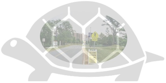
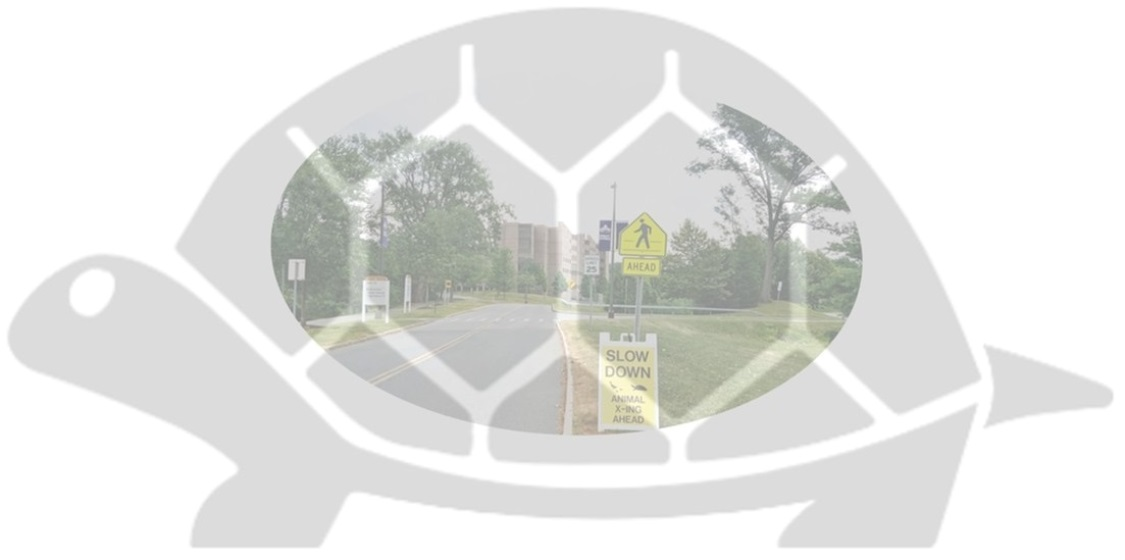
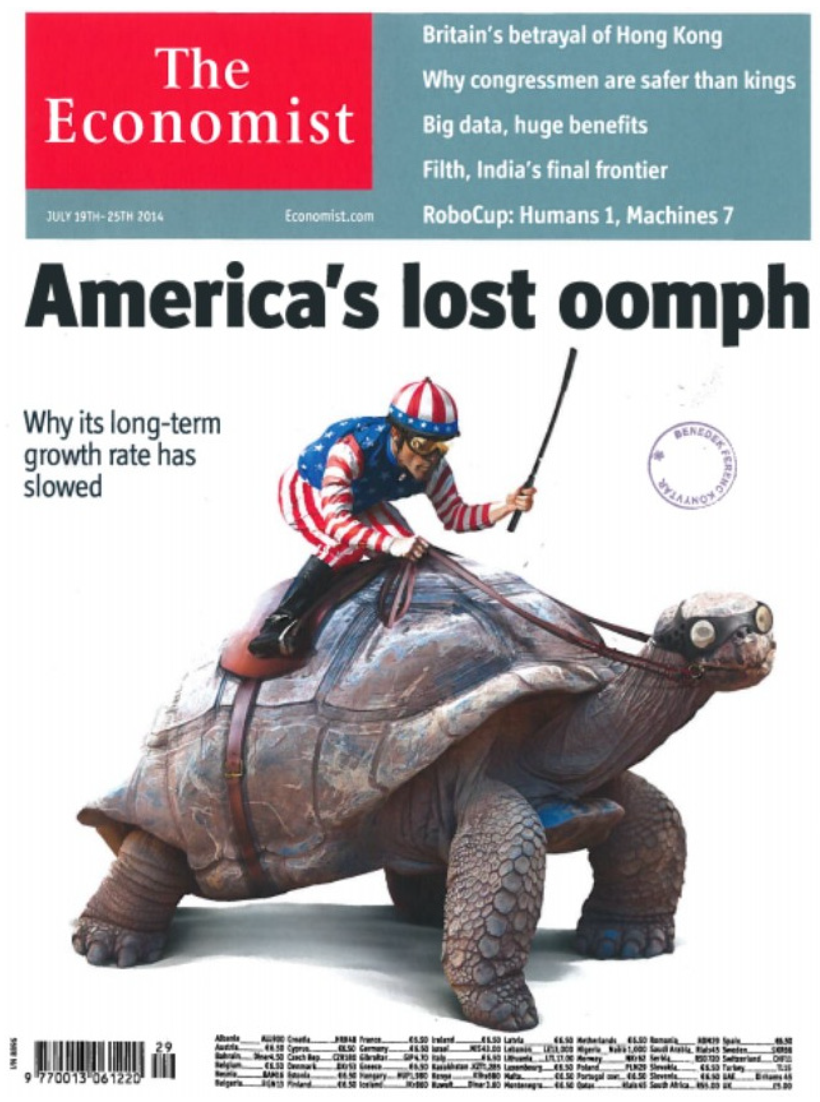
Typically, urbanizing areas grow by expanding up and outwards. In the Anthropocene, the latter movement, typical of urban growth machine developments, tends to cause encroachment upon natural habitats and to increase the interface between humans and wildlife [1,2] in what amounts to severe habitat degradation [3,4] and intense anthropogenic pressure [5]. Property development, roads, vehicles, and overall urban development cause biodiversity habitat fragmentation. Some herpetofauna are at risk from a conservation perspective [6], even being utilized in popular media for uses not conducive to needed conservation goals (see Figure 1). This phenomenon is simultaneously a road ecology, biodiversity conservation [7], and public health problem [8], since it decimates biodiversity, and it also potentially spreads diseases from the carcasses on the side of the road [9]. The study area consists of approximately 323 hectares in upstate New York, more specifically, in uptown Albany and southeastern Guilderland. This study continues earlier research by the author involving sustainable transportation campus planning [10], creative and sustainable town–gown interactions [11,12], and visual and multisensorial sustainable urban planning and landscape knowledge on college campuses [13].
In 2022, the Journal of Urban Affairs published a thematic issue dedicated to “Animals in the City” [9]. In that Special Issue, it was recognized that “human and non-human fortunes are tied in a complex web of relationships that are ripe for urban research” [15] (p. 113). Furthermore, the opening article of that Special Issue asserted “to serve as the starting point for an ongoing conversation about how urban affairs scholars can better accommodate the other animals sharing the urban world in their research and applied work” [16] (p. 134). More recently, Mitchell reviewed data from the repositories of animal-relevant legislation proposed and enacted by NYC city council from 1990 through 2023 and discovered that wildlife conservation was one of four emerging concerns in animal policymaking in New York City [17].
This article was initially prepared as a contribution to a thematic issue on the sustainable coexistence of human–wildlife interactions. As such, it acknowledges and attempts to fill the following two gaps in the current literature: (i) the need to sustain coexistence with wildlife, which requires not only technical and ecological interventions, but also community-based governance models, behavioral adaptations, and ethical frameworks and (ii) the growing challenges posed by biodiversity loss, urbanization, and changing human–wildlife relationships, which call for interdisciplinary and transdisciplinary scholarship that can inform effective policies, foster inclusive governance, and support the development of adaptive, community-led solutions [18].
The article also attempts to answer the following four topic areas: (i) community-based approaches to wildlife conservation; (ii) ethical and moral dimensions of human–animal encounters; (iii) urban planning and green infrastructure for biodiversity; and (iv) multispecies justice, animal agency, and civic responsibility [18]. It is worth noting that an earlier call by the same guest co-editors on human–animal interactions and sustainable local governance claimed that:
“Systematic theories, suitable methodologies and practical guidelines for capturing the administrative effects of encounters between people and animals and their consequences for sustainable local governance and policies are in their infancy. However, regulators and local authorities are already forced to cope with issues related to sustainability far beyond the ecological aspects that are reshaping the social, cultural and political fabric of the world. Regulators and local authorities must develop a spatial response to this new reality in which animals and wild animals enter and dwell in rural and urban spaces”.
[19]
This article would fit neatly in at least two of the topic areas proposed back then: (i) sustainable local governance, animal regulation, Zoopolis, biophilia and animals’ ‘right to the city’ and (ii) wildlife management, ecology, and sustainable local governance [19]. However, specifically on college campuses, Guthula et al. claimed that “[a]cademic campuses could be new avenues of biodiversity conservation outside protected areas” [20] (p. 1). This article is significant because it fills an unresearched gap on the impact of the “campus-based growth machine,” roads, vehicles, and suburban sprawl on biodiversity habitat fragmentation in the U.S. [21]. First conceptualized in the mid-1970s by Molotch [22], the growth machine effect was defined as the outcome of a set of land-based elite actions implemented to profit from increasing the intensification of a given land use in which such members hold a common interest [23]. The associated urbanization model tends to assure increased land values and more attractive areas for future development [24].
The study’s main objective was to analyze herpetofauna habitat fragmentation around various wetlands in Albany, New York. The article also identifies potential mitigation measures, including the installation of protective fencing and the construction of underpasses on the roads surrounding the wetlands on the University at Albany main campus. As most of the growth machine literature published to date deals with human communities, with Fitch’s The Assassination of New York published in 1993 [25] among the most seminal books in New York State, this study is likely to be one of the first to analyze the growth machine effect on a biodiversity conservation theme involving a university campus. This became self-evident in the fact that the urban intensification caused by the growth machine developments appeared to be putting additional pressure on existing wildlife habitats in the study area.
More specifically, the research reported in this article aimed to update the existing knowledge on herpetofauna populations in uptown Albany; to potentially engage students, staff, faculty and community members with on-campus biodiversity activities; to discuss various habitat mitigation measures; to include the installation of barriers and the construction of underpasses; to monitor biodiversity crossings in the area and maintain the integrity of the protective measures; and finally, to disseminate the research results.
The study’s hypotheses are that the campus’ wetland system has high biodiversity conservation value and, given the property development boom around the uptown campus, its current herpetofauna habitat fragmentation needs proper road crossing mitigation measures. The species present in the study area include the snapping turtle and the painted turtle. The Eastern garter snake and various species of frogs could also indirectly benefit from the protective measures proposed in this study. The habitats are located adjacent to the Indian Pond1 and in the vicinity of one university dormitory and of a major arterial road and shopping plaza.
The desired conservation outcomes were the creation of a more continuous habitat, uniform underground crossings, and the elimination of biodiversity road crossing deaths. The educational outcomes comprised direct engagement of the campus and community populations, greater awareness of the need for biodiversity conservation in contexts of intense urbanization, and the dissemination of the project’s results [26,27]. In brief, the research methods comprised both qualitative and quantitative assessments of property development inventories, wildlife observations, student engagement, and biodiversity monitoring at the University at Albany, the cataloging of test-design and conservation measures, and the review of institutional planning regulations and roadway design features. The key finding is the need for more, not less, biodiversity conservation innovations to increase the continuity of habitats, uniform underground crossings, and the elimination of herpetofauna road crossing deaths.
The article is in five parts. Following this Introduction, Part One is the analytical mechanism on biodiversity habitat fragmentation, the American college campus, and the “Anthropocentric” and “Biocentric” worldviews. Part Two explains the methods and settings. Part Three is the study’s investigation centered on three main themes: (i) the fauna in and around the campus wetlands, (ii) the current herpetofauna habitat fragmentation, and (iii) the augmentation of the ecological value of the uptown campus of the University at Albany. Part Four discusses four broad implications of the study. And Part Five concludes with research and practice recommendations to obviate the campus growth machine effect.

2. Analytical Mechanism

This analytical mechanism briefly introduces two main themes: biodiversity habitat fragmentation and road ecology, and campus development and wildlife conservation under the broad theme of sustainable urbanism. Herpetofauna habitat fragmentation is a serious problem throughout the world. The construction of roads and urban development contributes to said phenomenon [28,29]. Roadkill is a significant threat to the survival of many federally listed threatened species in the U.S. [30,31]. Contrary to, for instance, birds that fly and can still live in cities [32], wildlife species without wings suffer disproportionately from the negative impacts of urbanization and motorized traffic noise, air pollution, and road and parking trepidation.
A recent review of studies on wildlife–vehicle collisions synthesized a high number of factors into these four main categories: (i) species characteristics, (ii) road and traffic characteristics, (iii) landscape and environmental characteristics, and (iv) driver-related factors and specific human activities [33]. Roadkill and herpetofauna habitat fragmentation result from a combination of the factors in these four categories. The planning and engineering solutions to these problems typically involve the promotion of safe road crossings through the elimination of barriers to movement [33,34]. Furthermore, Perrelet et al. demonstrated the value of blue–green infrastructure on three fronts: (i) the importance of species diversity, abundance, and ecological processes, (ii) to improve engineering performance and resilience, and (iii) to lower management costs [35].
There have been various attempts at raising awareness of this road ecology problem [36,37]. However, in New York State, only a limited number of road ecology issues have been studied over the years [38,39]. Habitat fragmentation and mitigation measures appeared to have received the most attention [40]. When researching this scenario on the ground, Nelson et al. discovered that the New York State Department of Transportation had created some pilot partnerships with local communities aimed at installing barriers and constructing underpasses in central New York during the mid-2000s [41].
Researchers in Potsdam, New York, have also been actively engaged in the study of herpetofauna conservation measures, namely through the installation of protective barriers along Route 68, three miles from Canton at a place where cars were killing an estimated 80 turtles each year [42]. However, in the Capital Region of upstate New York, besides a recently conducted study of various planning approaches to mitigate habitat fragmentation by transportation networks in the area around the Albany Pine Bush Preserve [43], there have been no other specific attempts at researching and/or mitigating herpetofauna habitat fragmentation.
The American College Campus typology has been dutifully noted [44,45,46]. The format of a common courtyard surrounded by academic and residential buildings goes back to the foundation of the country and to emblematic campuses such as those of the University of Virginia, Mount Holyoke College, and Rensselaer Polytechnic Institute (RPI), which were mostly inspired by Thomas Jefferson’s and Frederik Law Olmstead’s visions and designs for the campuses of the University of Virginia and Mount Holyoke College (Western Massachusetts), respectively.
On campus grounds, Brown has recognized that wildlife habitat protection ought to be accomplished by contextualizing and identifying wildlife habitat needs within traditional land-use planning controls [47]. In adjacent lands, Bonnie suggests that “mitigation banking” is a powerful way to increase mitigation alternatives for the community while providing needed economic trade-offs for other landowners to restore and protect important biodiversity habitats [48]. Wu et al. examined the impacts of expressway construction projects on the natural environment, while also documenting the scope of those environmental impacts from a government management perspective [49].
Many U.S. university campuses, similarly to airports, appear to be undergoing regular expansion. This education-related property expansion also commonly takes place on campus grounds and in adjacent neighborhoods [23,24,50], often leading to residential displacement and gentrification tendencies [51,52,53]. On campus, open spaces traditionally give place to new buildings, parking garages, and dormitories. Globally, properties adjacent to university campuses are converted by real estate entrepreneurs into urban developments intended to serve the various campus’ constituencies [54]. A 2005 collection also edited by Wiewel and Perry on the role of the university as urban developer in the United States made no mention of biodiversity conservation on campus grounds [55]. Fortunately, the tide seems to be changing domestically and internationally [56]. In South Korea, the Seoul Metropolitan Government has initiated projects to create campus towns to strengthen the sustainable win–win growth of universities and communities [57].
More comprehensively, Farinha-Marques et al. have examined the relationship between biodiversity, spatial form, sustainable design, and management within the urban realm to conclude that said approach can promote the development of “integrated planning and design solutions to encourage green structures in the urban realm, according to contemporary social needs and grounded on a deeper understanding of urban ecosystems” [58] (p. 247).
Central to the article successfully published in a Special Issue on “Sustainable Coexistence: Interdisciplinary Perspectives on Community-Based Conservation and Human–Wildlife Encounters” [18] is Beeri and Segev’s distinction between “Anthropocentric” and “Biocentric” worldviews, where it is explained that the distinction represents “two fundamentally different orientations toward the relationship between humans and nature” [59] (p. 2). In fact, according to the two authors, “Anthropocentric framings prioritize human welfare, safety, and control, often portraying wildlife as disruptive or hazardous to urban life (…), and [B]iocentric framings emphasize coexistence, ecological reciprocity, and the intrinsic value of non-human life” [59] (p. 2). Furthermore, this article also attempts to advance the 2023 Kunming-Montreal Global Biodiversity Framework’s main Biocentric goal adopted by 196 nations to halt and reverse biodiversity loss by 2030, while striving for “living in harmony with nature” by 2050. Hence, the Anthropocentric vs. Biocentric worldview distinctions provide the core analytical lens for the specific University at Albany case study discussed in this article.

3. Setting and Methods

The study area comprised two academic campuses (University at Albany and the College of Nanoscale Science and Engineering), one professionally run shopping plaza (Stuyvesant Plaza), one shopping area (Western Avenue and University Place), and two residential neighborhoods located north of Western Avenue, one of which is in the town of Guilderland (severed by Fuller Road) and the other in the City of Albany, just east of the shopping area. The main wetland, the Parker Pond (1.9 hectares), is on the uptown campus of the University at Albany, State University of New York. The complete wetland system is fully characterized below.
The uptown campus is located on the most western tip of Albany, New York. This campus is a suburban style development designed by Edward Durell Stone in 1961, with a central podium and a courtyard surrounded by four quads, various dormitory and service buildings, parking lots, sports fields, wetlands, and forested patches of land. The campus is located between the Patroon Creek watershed to the north (i.e., Rensselaer Lake and water reservoir), the southeastern tip of the Albany Pine Bush Preserve [60], and the Krum Kill Creek watershed to the south. The campus has a non-traditional municipal separate stormwater management system, and the University is a member of the Stormwater Coalition of Albany County.
The Parker Pond is the inception of the Krum Kill Creek and the largest wetland on the main campus. The pond is a functioning stormwater retention basin and source of irrigation water for the uptown campus. This pond is also known to support various plants and animal species [61]. This artificial body of water was dredged in 2008 to remove accumulated sediments and to regenerate its system-wide ecological functions and networks [62].
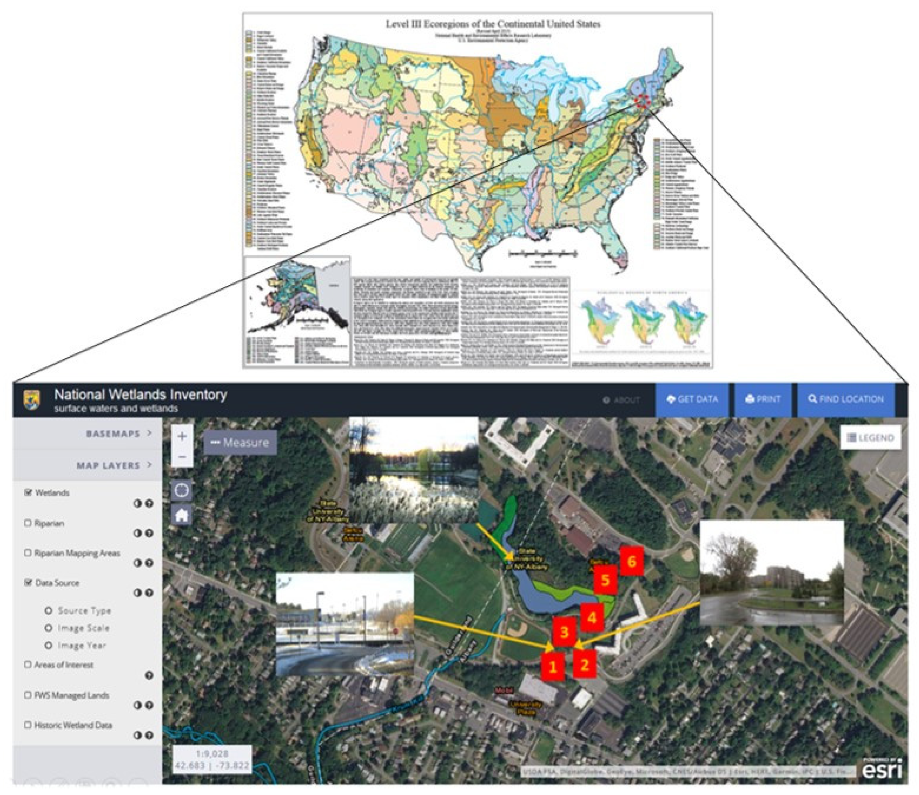
The Parker Pond is tucked away on the southeast corner of campus, next to a small patch of forested land. The pond has a pedestrian bridge for connectivity and various attractive viewing areas. Informative plaques about the area’s fauna and flora have been installed to educate visitors about the system’s unique biodiversity characteristics. The other campus wetlands are smaller ponds to the south and north of Parker Pond, one of which is fenced off to the public and the others are open for viewing from afar. The wetland system is partially encircled by a localized and unpaved walking path. The highest concentration of wetlands is within the broad 323-hectare study area of uptown Albany, and the main focus of the study is shown in Figure 2.
A campus-wide multi-purpose trail, called Purple Path, encircles part of the study area and is used mostly for walking, jogging, and bicycle riding. This path was the result of an applied project envisioned by faculty and students in the mid-2000s. A new dormitory called Liberty Terrace was built adjacent to these wetlands in 2012. The wetlands are bisected by two roads, University Drive East—a segment of the ring road around the whole campus—and a connector road linking University Drive East to University Place—an area with two university buildings and parking lots.
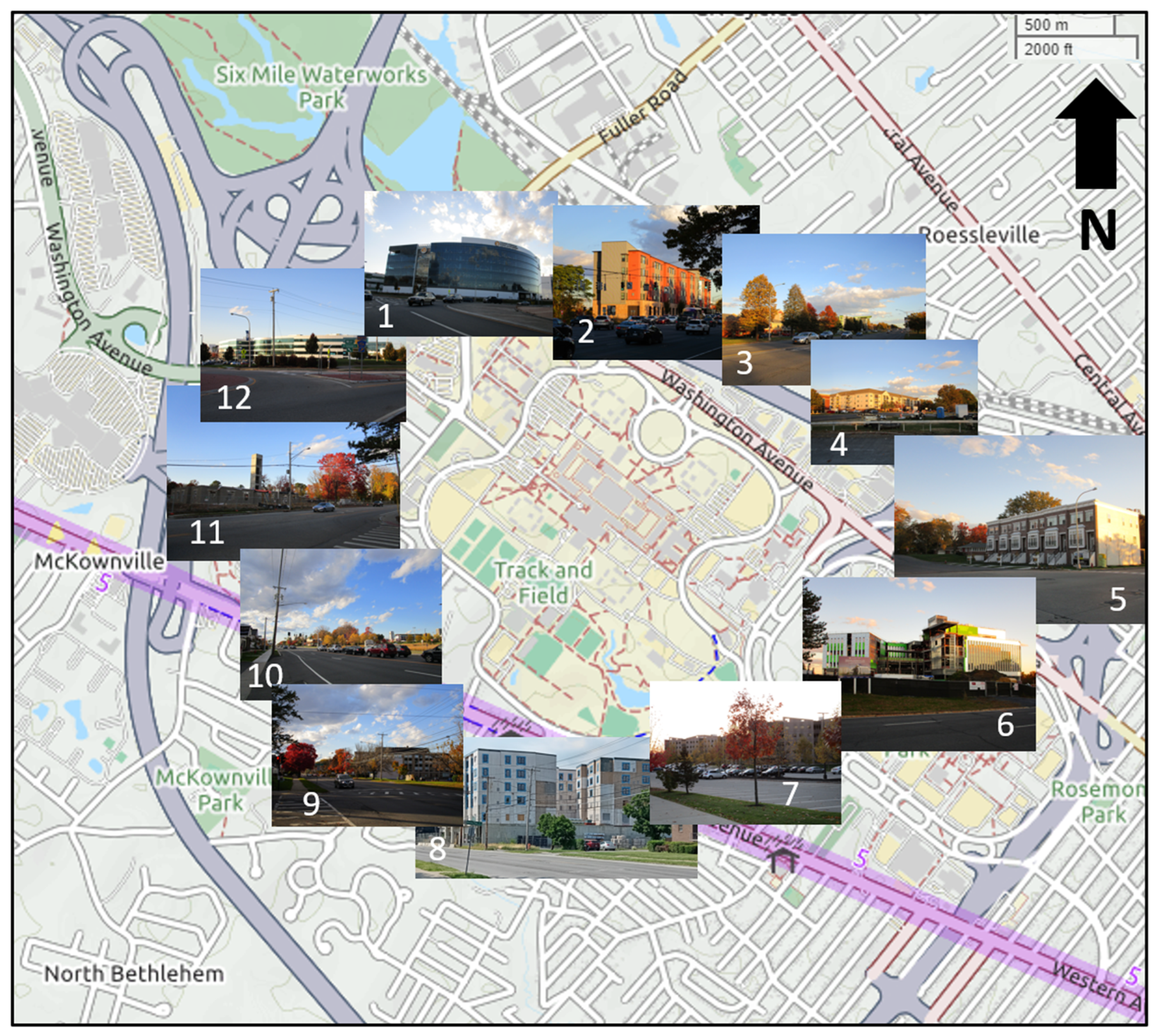
This southern part of campus is bordered by the high-capacity arterial road Western Avenue (U.S. Route 20), one of three important east–west roads in Albany. Other wetlands in the study area comprise a small wetland between the Stuyvesant Plaza and Western Avenue in the Town of Guilderland, just west of Fuller Road, and a small rainwater retention basin on the northwest corner of the campus bordered by Washington Avenue Extension and Fuller Road. The study area has been experiencing added suburban development pressure due to the expansion on and around three campuses, the University at Albany, the College of Nanoscale Science and Engineering, and private developments adjacent to both campuses and surrounding the W. Averell Harriman State Office Building Campus. Table 1 and Figure 3 show the most significant growth machine property developments and one civic movement on and around the three state campuses in uptown Albany.
The property developments can be categorized into two main groups: (i) education-related developments promoted by the State of New York, and (ii) housing, student dorms, and commercial developments promoted by private developers. The civic movement Stop the Stories initiated in 2017 aims to reduce the recent incidence of suburban sprawl redevelopment and to preserve the character of the residential neighborhoods along Western Avenue. This urban intensification caused by the growth machine is likely to put additional pressure on existing wildlife habitats in the study area [63]. Recent construction works on Western Avenue have also been causing road traffic congestion, especially during rush hours, and quality of life discomfort to residents and university workers in the area.
The methodology comprised a longitudinal place-based mixed qualitative-descriptive research approach that combined multiple years of applied field research with wildlife observations. The specific research methods ranged from a windshield property development inventory (i.e., a visual survey conducted from behind the windshield of a moving vehicle) to wildlife and biodiversity counts, student engagement, and biodiversity monitoring, the inventory of test-design and conservation measures, and the review of campus cartography, institutional planning laws and regulations, and roadway design features [64].
Road ecology modeling principles such as Connectivity and Corridor Modeling, Habitat Suitability and Road-Effect Modeling, Road Mortality and Risk Mapping, and Landscape and Simulation Modeling [65] were taken into consideration during the proposal, implementation, and writing phases of the study. Furthermore, this study was informed by the author’s four years of continuous daily biodiversity observations (est. 1600 observations: 800 during the morning period and 800 during the evening period) during the academic year (August–May) and also sporadic summer term observations (est. 160 observations: 80 during the morning period and 80 during the evening period), comprising a total of 1760 observations. These observations were standardized to the extent possible by always walking through the same transect locations and spending about the same amount of time inventorying herpetofauna. The summer observations revealed much lower levels of car traffic through the study area and a much lower student presence on campus grounds. Paradoxically, during the summer holiday period, campus planning placed various Animal Xing crossing signs to help duck populations safely cross the street (more recently, said sign was redesigned to also feature turtles).
In general, these observations, lasting anywhere between approximately 15 and 20 min each, were conducted in all types of weather, with temperatures ranging from −31 to 45 °C and precipitation conditions ranging from snow to sunshine, through the southern conflict zone in the study area (i.e., where the ring road bisects the wetland system). They were documented manually and, in certain cases, with photographs. No night-time observations were conducted. The majority of these methods allow for the replicability of the study through in loco verification and for the results to be reproduced. Table 2 presents a synthesis of the data collected in the study.

4. Study’s Investigation and Results

4.1. Theme 1—Fauna in and Around the Campus Wetlands

According to Table 3, adapted from the 2009 Draft Generic Environmental Impact Statement, the fauna observed in the vicinity of the University at Albany campus’ wetlands have included the red fox (Vulpes vulpes), woodchuck (Marmota monax), deer mouse (Peromyscus maniculatus), little brown bat (Myotis lucifugus), various fish species, Canada goose (Branta canadensis), snapping turtle (Chelydra serpentina), Eastern painted turtle (Chrysemys picta), and Eastern garter snake (Thamnophis sirtalis) [61] (pp. 126–127). According to the same source, several federally listed endangered or threatened species likely to exist in Albany County include the bog turtle (Clemmys muhlenbergii), Indian bat (Myotis sodalist), and Karner blue butterfly (Plebejus melissa samuelis).
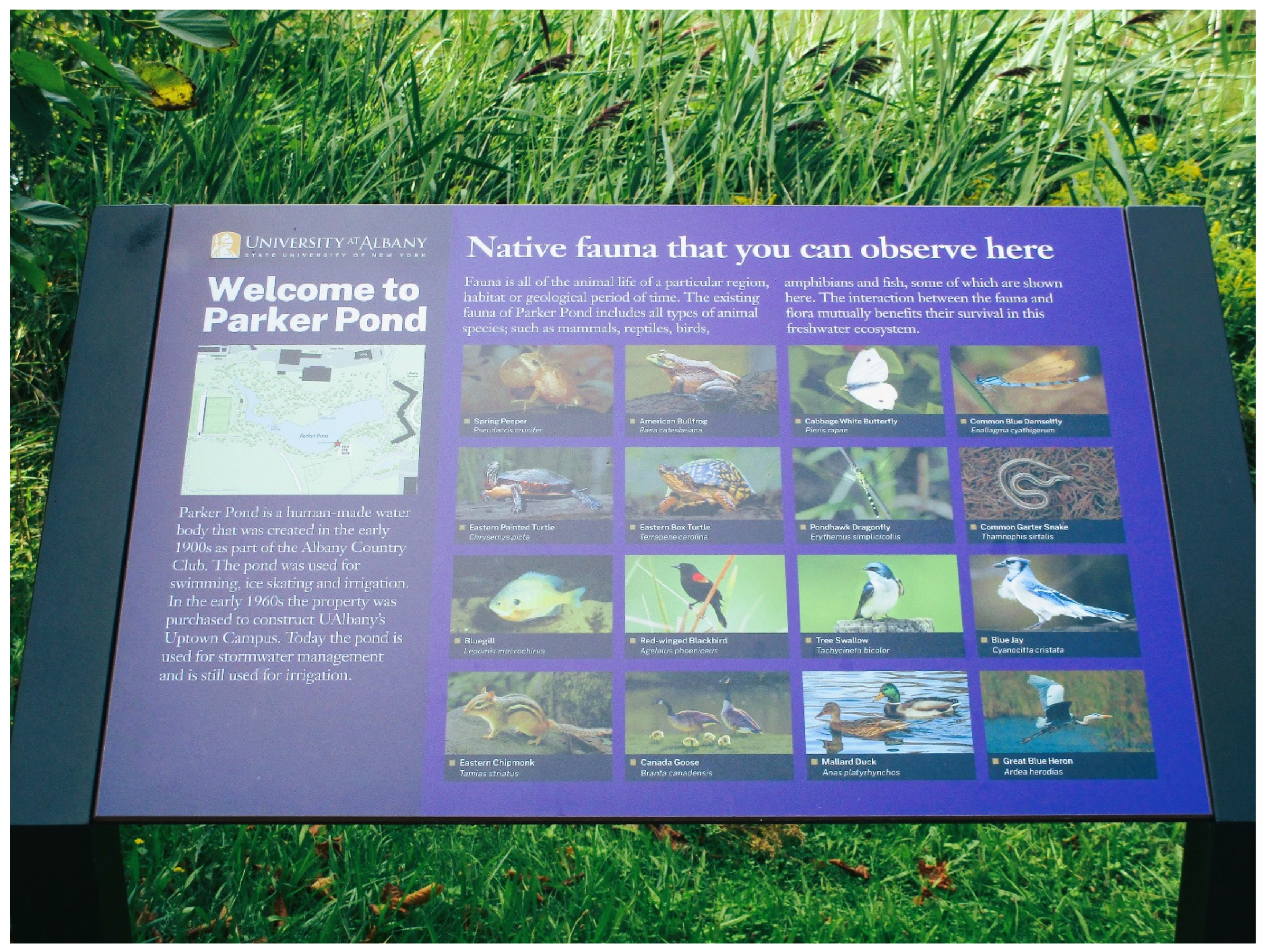
On the other hand, state-listed rare, threatened, and endangered species include the frosted elfin (Callophrys irus), Karner blue butterfly (Plebejus melissa samuelis), inland barrens buckmoth (Hemileuca maia maia), and worm snake (Carphophis amoenus) [61]. This is evidence of high biodiversity value, which, on campus grounds, has been made public by the placement of informative plaques about the area’s fauna and flora. This also serves to validate hypothesis one. These educational plaques have been installed to elucidate visitors of the system’s unique biodiversity characteristics (Figure 4).
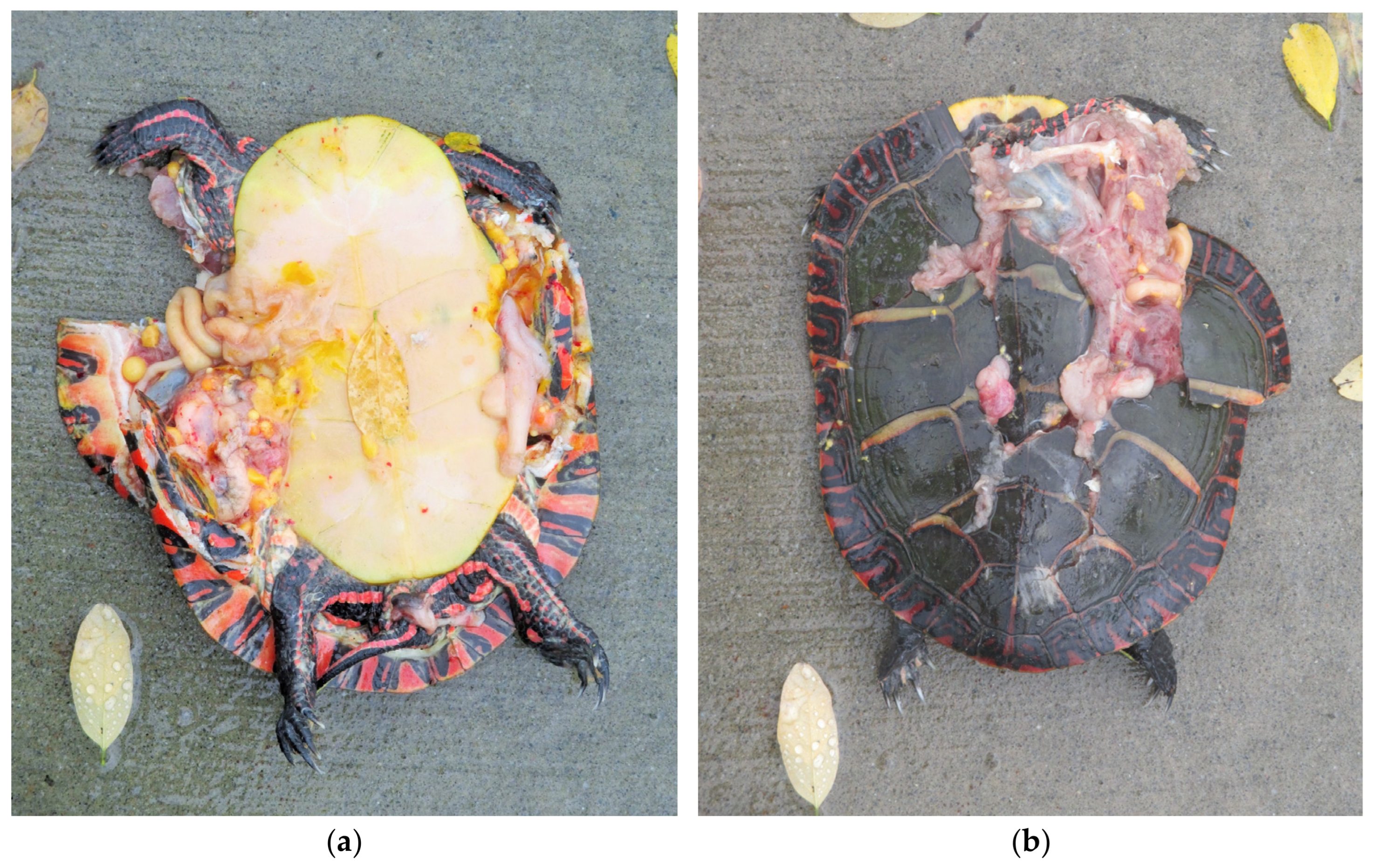
The main motivation for this study was the observed presence of many small turtles around the campus’ wetlands and the death of herpetofauna on University Place adjacent to University Drive East. Follow up debriefings with faculty, students, and staff confirmed the existence of turtles by eyewitnesses who have counted “at least 10 turtles” at a time during single visits through the Parker Pond area and a very high number of squirrels killed in the ring road adjacent to Liberty Terrace (i.e., external validation via personal interviews with students and staff on campus) (Figure 5a,b). Frogs and other small vertebrates have also been confirmed in the wetlands in the past [66].
Early on, the construction of the Liberty Terrace dormitory in 2012 brought added pressure to these sensitive faunistic resources. The rerouting of the connector road between University Place and the campus ring road, further bisecting the wetland system with the creation of an infrastructure barrier, which altered the movement patterns of herpetofauna in the area, is evidence that the herpetofauna habitat has been altered due to new road and building construction.
Furthermore, the wildlife roadkill observed on the road itself and adjacent planting areas, especially at the intersection of E. University Drive with University Place, the increase in the number of vehicles passing through the area, and the confirmation to the author by a transportation official with experience in coordinating the first large scale study on the mitigation of habitat fragmentation due to transport infrastructure in personal communications with transportation officials, suggesting the potential localized extirpation of the bog turtle [67], all constitute ample scientific evidence that the habitat has been altered due to human-induced activity and intensified campus expansion and associated growth machine development in the area.
Since, in uptown Albany, only one formal study of herpetofauna analyzing the environmental associations of herpetofauna communities in the Pitch Pine–Scrub Oak Barrens of Albany County, a sensitive preservation area to the west of the Albany campus, was found during the desk research phase of this study; the article is believed to be innovative in the sense that it calls attention to the direct relationship between intensified development and reductions in biodiversity conservation.

4.2. Theme 2—Herpetofauna Habitat Fragmentation

Based on the examination of historic cartography, it is asserted that, in addition to the construction of the university dormitory in 2012 and its adjacent parking lot, the rerouting of University Place has further bisected herpetofauna habitats in this wetland system. Although more accurate research on habitat characterization and herpetofauna movements would need to be conducted, the existence of a major segment of University Drive East—the ring road around campus—and the rerouted connector road, University Place, through the wetlands constituted major barriers to herpetofauna movement and have even accentuated habitat fragmentation (please consult Figure 2 for the severed geo-coded wetlands 1 and 2, numbered in red on the map, completely bisected by the ring road from the originally connected wetlands 3–6). This is the case specifically between the Parker Pond and various wetlands on the north side of University Drive East and a stormwater retention basin on the south side, known for its seasonal duck habitat.
The connector road also separates the stormwater retention basin from a long stretch of grassland between the shopping plaza and University Drive East. Although a long culvert with a narrow diameter to channel rainwater from this grassy area east of the University Place Street to the stormwater retention basin was installed during the street rerouting, its extremely long and quite narrow diameter is highly likely to be ineffective at enticing herpetofauna into using it to reach different geographic areas of the habitat ecosystem (low altitude grassland patch, pond, vernal pool, small wetlands, and gently sloped hill).
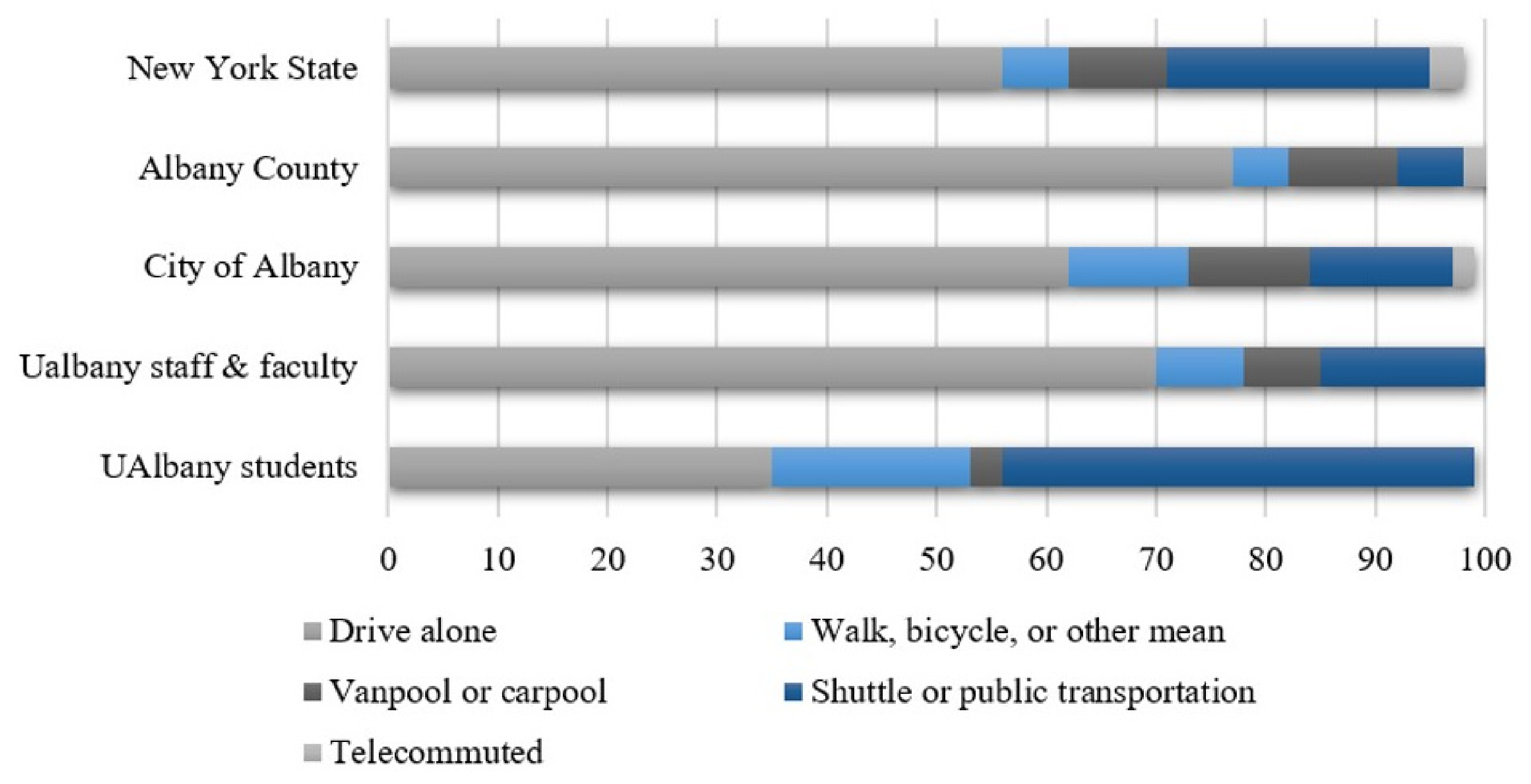
Traffic data from before the construction of Liberty Terrace indicated 437 vehicles per hour on University Drive East. According to official city data, Western Avenue, a block away from the wetland habitat, carries anywhere between 25,000 and 38,000 vehicles per day, depending on the time of the day and day of the week. Figure 6 shows the modal share on campus for students, staff, and faculty in relation to the modal share in the City of Albany, Albany County, and the State of New York. The data demonstrate that, following national trends [10], college students are more environmentally sensitive to the problems caused by automobile dependence (such as traffic pressure and roadkill rates), as they walk, bike, and take public transportation at higher rates than other campus constituents and the overall county and state population.
Some efforts at encouraging more sustainable travel practices have also been attempted in the past [69]. Attempts by small turtles at crossing these streets have been observed by multiple individuals on campus. Furthermore, regularly (and systematically), various small turtles even had to be moved from the adjacent sidewalks toward higher ground, away from the road, to avoid additional biodiversity roadkill. A principal component of this study was to analyze the existing herpetofauna habitat, to identify measures to mitigate habitat fragmentation, and to facilitate habitat connectivity, potentially through the installation of protective barriers, the construction of underpasses, and the replacement of existing pipes.

4.3. Theme 3—Augmenting the Ecological Value of the Uptown Campus of the University at Albany

The University at Albany’s modernistic campus built in the early 1960s makes use of a central fountain and water tower instead of a central lawn. Nonetheless, its design concept is identical to the prototypical North American campus, with the simple difference being that the original residential villages are vertical mid-rise quads with basic services and dorms instead of simple student residences. The suburban setting away from regular urban neighborhoods has enabled it to provide ample surface parking interspersed by landscaped open space patches of grass and forested land [70], reminiscent of the original pine bush ecosystem present in the area before the construction of the campus in the early 1960s [71].
The uptown campus is affected by a high number of laws, regulatory documents, plans, policies, and studies. Except for the Draft Generic Environmental Impact Statement conducted in 2009, prior to the construction of the Liberty Terrace dormitory, most other regulatory documents have neglected biodiversity conservation measures. Valuing biodiversity on and off campus ought to be encouraged, and therefore, this study is committed to protecting and conserving existing species through the most advanced biodiversity conservation policies and practices [72].
Advances in ecological thought, sustainable urbanism, sustainability science, and innovative sustainable sociotechnical systems [73,74,75,76,77] have partly contributed to the construction of Leadership in Energy and Environmental Design (LEED)-certified buildings on campus grounds (e.g., Life Sciences building, Liberty Terrace, and west wing of the campus center). The LEED standard of smart materials and design approaches (i.e., recycled, reclaimed, locally produced, and responsibly obtained) helps conserve energy and preserve the environment. Although parking space is a major requirement in commuting campuses, it is noted that many other suburban campuses have utilized their grounds in ways that enhance their flora and fauna habitats, while serving as educational grounds for active learning [78], a lot more than the University at Albany main campus.
Arboretums and gardens (e.g., botanical, classical, Japanese, and community) can be found in well planned and maintained campuses throughout the United States. These spaces enable active learning outside of the classroom in one’s own backyard [79]. It is asserted that the wetlands on the University at Albany’s uptown campus can be further utilized to foster student learning and engagement with in situ understanding of unique ecosystem functions and habitat conservation measures [80].
Therefore, the article suggests that the university campus would become more competitive with its peer institutions, not only in terms of research and teaching efforts, but especially in terms of sustainability, fauna and flora conservation, ecological thinking, and additional applied learning opportunities for the campus constituents and members of the community [76], if herpetofauna habitat fragmentation were to be mitigated to its fullest extent.
Finally, the difference between human (“Anthropocentric”) and non-human (“Biocentric”) safety is illustrated with the use of more than 700 m of a property fence on the northern border of the campus adjacent to Washington Avenue between the intersection of W. University Dr, Washington Avenue, and the on–off Interstate I-90 ramps (Interchange 2) to the west and the Campus Access Road to the east, just across from more than three private university student dormitories, labeled as 2, 3, and 4 in Figure 3 above. With an average daily traffic of 20,000–30,000 vehicles, Washington Avenue carries an Annual Average Daily Traffic (AADT) relatively similar to that of Western Avenue at the campus’s southern entrance (see Table 2 above). Said campus border fence was installed in summer 2024 after a deadly crash between a pedestrian and a vehicle. A series of 2024 Reddit and Facebook posts (see Box 1 and Box 2, respectively) are added here to illustrate the public perception of pedestrian safety arrangements in the area.
Box 1. Reddit post and comments: What about that new border fence? [81].
Reddit open access post:
What about that new border fence? So, a few months ago a pedestrian got hit on Washington ave. They were not a student as far as I know, but everyone immediately speculated that it was only a matter of time before a student was hit crossing the street. Obviously, they need better pedestrian infrastructure to accommodate all the new student housing directly across Washington avenue from UAlbany. But in typical Albany fashion, instead of doing the right thing they are building more pedestrian-hostile infrastructure. This fence surrounding campus is clearly meant to deter pedestrians from crossing Washington ave directly from student housing and push them to beg buttons at inconveniently distant traffic lights.
Comment #1
It looks dumb and it 100% looks like it is meant to deter students from walking across Washington anywhere except for the three crosswalks. [T]he city should have required the new apartment builders to install a bridge or some other method to help cross safely. Instead, UAlbany has to look like the a***ole.
Comment #2
The city needs to apply traffic calming to Washington avenue, in my opinion. Something like, take away a lane of traffic on each side for parking or protected bike lane, turn the center lane into a grassy median with trees. Basically, make it a PITA to drive on, reduce speed limit to 20 or 25. Then students would be a lot safer crossing the street.
Comment #3
Oh, absolutely. They should have never approved student apartments at this scale without an eye to Washington Ave safety. Silly.
Box 2. Facebook post and comments: Anyone remember when that pedestrian was killed on Washington Ave in front of UAlbany? [82].
Facebook open access post:
Anyone remember when that pedestrian was killed on Washington Ave in front of UAlbany? Everyone speculated it was a student crossing back to their apartment complex and argued convincingly for improved pedestrian infrastructure and traffic calming. Well action has been taken this summer, and it is this hideous border wall, that blocks all crossings except sparse beg button intersections. I hate it.
Comment #1
I have witnessed several near misses on this stretch of Washington. It isn’t lit well at night. It’s difficult to see students crossing. I agree, I would have liked to see a better plan than this fence.
Comment #2
Pedestrian fencing can be useful in reducing car/ped crashes, but should be combined with speed reducing measures like those in the long lost Washington Ave Extension Traffic Study and safe, fully signalized midblock crossing options with raised crossings. They should have been paid by the developers—and should certainly be a requirement of future development.
Comment #3
Yup. The onus is really on the developers, the planning board and the city to think about these things. I brought up these issues in my last letter to the editor but obviously, more noise is needed.

5. Discussion of Findings and Implications

The hypotheses stated in the introduction are that the campus’ wetland system has a high biodiversity conservation value, and its current biodiversity habitat fragmentation needs proper road crossing mitigation measures. The first hypothesis was corroborated by studies conducted in conjunction with the design, permitting, and construction of the university dormitory Liberty Terrace [61] and the placement of informative plaques about the area’s fauna and flora, which have been installed to educate visitors of the system’s unique biodiversity value. The second hypothesis was confirmed by observations and the precise documentation of dead herpetofauna and inadequate culverts’ placement, diameter, and length and in loco reported observations (“at least 10 turtles of various species found around the Parker Pond wetland area during regular visits”—interviewees’ oral statements provided to the author in January 2018). Therefore, the following paragraphs discuss these four broad implications: on-the-ground restoration; environmental outreach, education, and training; community partnerships; and measurable results and sustainability.
On-the-ground restoration: This research addressed key species and habitats and directly links to established watershed and conservation plans. Concerned attention has been given to the conservation of various species of turtles (e.g., snapping turtle and bog turtle), although other herpetofauna (including salamanders) could also potentially benefit from the biodiversity conservation measures identified in this study.
Environmental outreach, education, and training: The engagement of the public in outdoor conservation experiences is extremely important in road ecology. Community outreach involved various on-campus constituents, multiple public members from the community, and even students and teachers from adjacent high schools in Albany (e.g., Albany School District and Green Tech High School). Regular field visits conducted by the author with undergraduate and graduate students in the Urban Design course in Spring 2018 and Spring 2019 through various parts of the campus grounds, including the area surrounding Parker Pond, revealed some accumulated trash and debris in the most recondite and inaccessible parts of the pond. Although many campus community members regularly take part in neighborhood clean-up efforts within the context of community service campaigns and town–gown collaborations with off-campus communities [83], constituents from under-served communities, such as the South End and Arbor Hill neighborhoods in Albany, could also visit the university grounds and get engaged with educational programs aimed at increasing their understanding of watershed planning, stormwater management, habitat restoration, and biodiversity conservation.
Community partnerships: The potential for engaging community partners in achieving ecological and specific educational outcomes can be sought through partnerships at the watershed level. This research received support from various on- and off-campus regional non-profit leaders. The partnership was built upon the existing capacity developed among some of the partners, who participated in a Land Use and Sustainability Symposium in 2018 and in a 2016–2017 Documentary Screening series on diversity and inclusion sponsored by the University at Albany Office of Diversity and Inclusion.
Other educational partnerships with local high schools through the existing Liberty Partnerships Program and through other programs for students within the Albany School District who are at risk of dropping out of school could also occur in the future [11]. Efforts to augment this research with mentoring and tutoring activities could be expanded by fostering a stronger sense of ecological literacy and understanding of habitat conservation measures among under-served populations in the South End and Arbor Hill neighborhoods of Albany, for instance. An opportunity to develop and implement new biodiversity conservation, site and urban design, and road ecology plans is also anticipated [84].
Measurable results and sustainability: Measurable activities and metrics linking watershed to community outcomes are also important. Activities such as land and wetland restoration studies, livestock protection practices, stormwater runoff, and institutional capacity building may even help to leverage additional resources that can contribute towards community wellbeing [85]. Students who continue this line of research can learn valuable knowledge and skills, which may serve to motivate them to advance work in similar projects after graduation. Furthermore, elementary and high school students who volunteer or become familiar with this research are also likely to develop a stronger sense of ecological understanding, which may entice them to further their education by enrolling in biodiversity and sustainability programs.
Furthermore, the needs of priority and at-risk species, habitats, and conservation actions identified in conservation plans were also taken into consideration in this study. On the one hand, although the wetland resources on the university campus are not formally recognized as state or federal wetlands, the likelihood that several federally listed endangered or threatened species in Albany County may also be present on campus is high. On the other, state-listed rare, threatened, and endangered species such as the frosted elfin, Karner blue butterfly, inland barrens buckmoth, and worm snake would benefit from subsequent conservation advancements in the campus’ environment.
This study also helped strengthen some of the priorities identified through local planning efforts, including watershed and sustainability plans, e.g., the City of Albany’s Comprehensive Plan—Albany 2030, and the Climate Change and Vulnerability Assessment and Adaptation Plan (2013). Moreover, it also expanded the City’s emphasis on conserving the flora and fauna of the more traditional Albany Pine Bush Preserve, Rensselaer Lake Park and Preserve, Corning Preserve, and the Hudson River [86].
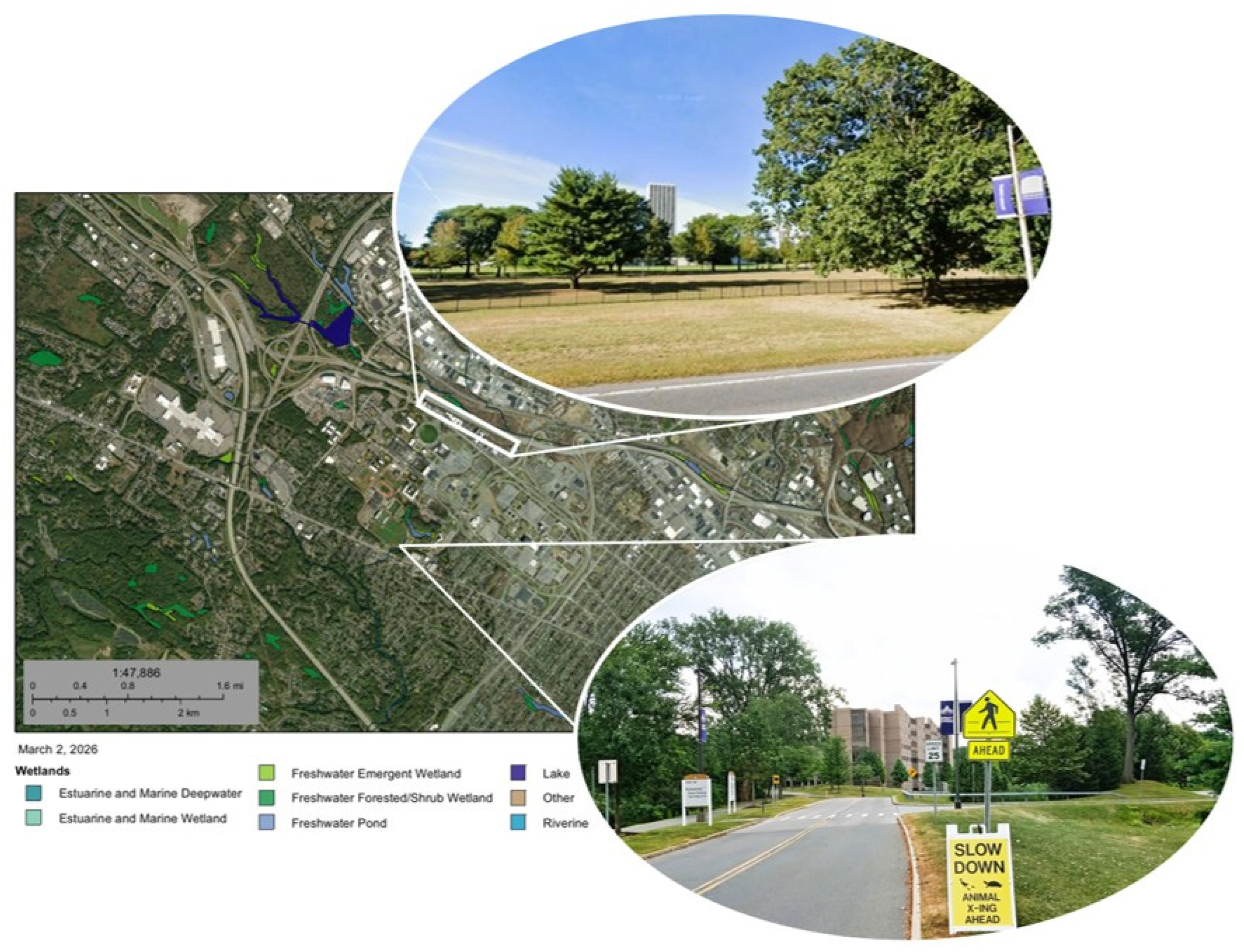
Recent visits in summer 2024 and summer 2025 to both the northern boundary of the University at Albany campus adjacent to Washington Avenue and the original turtle death hot-spot site discussed in this article (adjacent to the campus’s southern boundary along Western Avenue) demonstrate the innate priority given to the “Anthropocentric” worldview to install a border fence to protect tuition-paying students as opposed to protecting endangered wildlife species (“Biocentric” worldview), such as a specific variety of turtles as well as the non-endangered ones, as both could make use of the herpetofauna habitat mitigation infrastructure had it been properly constructed at the time the Draft Environmental Impact Assessment was conducted for the construction of the new Liberty Terrace student dormitory and the rerouting of the ring road around campus in the area bisecting the wetlands on the southeastern corner of the campus in 2009 (see Figure 2 above). Instead, said campus planning and road ecology dilemma has only received a name change (the Indian Pond was rechristened Parker Pond in May 2023, as the name Indian was determined to be at odds with the university’s values, and the name Parker was used to honor the first nine Indigenous students to enroll at the school around 1850) and a road-side sign (see Figure 7).
Furthermore, the University at Albany’s compliance with the Americans with Disabilities Act (ADA), let alone with endangered wildlife species, has been less than stellar. A case in point pertains to the placement of another sign, this time a “Closed for the Season” sign placed on a minimally inclined handicap ramp outside of the Liberty Terrace student dormitory granting access to the footpath surrounding Parker Pond, a mere 100 m from the turtle death hot-spot identified in Figure 2 above, can be perceived positively as a sign that the University at Albany demonstrates commitment to Anthropocentric management approaches and does care for the safety of all those who use the handicap ramp to the point of closing it off to users during the winter months. However, impaired individuals have access and mobility needs year-round, not only during the non-winter months. As such, the placement of said “Closed for the Season” sign can also be perceived paradoxically, in that impaired individuals (as well as individuals in wheelchairs and parents pushing prams) do not deserve the same level of care as everyone else who gets their sidewalks and footpaths cleaned after a snow-storm weather event, in disrespect of the Americans with Disabilities Act (ADA) federal legislation and New York State Human Rights Law.

6. Conclusions

The present study analyzed biodiversity habitat fragmentation caused by vehicles, roads, and suburban sprawl development around various wetlands in uptown Albany, NY. It also identified potential mitigation measures, such as the installation of protective fencing and the construction of underpasses on roads surrounding the wetlands on the uptown campus. This study has contributed to advancing knowledge of biodiversity conservation on and around state campuses, while also creating opportunities for community service collaborations in the greater upstate New York area and beyond.
One of the study’s limitations results from its case study approach to the research. Nonetheless, it is believed that Albany’s pre-eminence as New York’s state capital and the University of Albany’s uptown campus growth machine effect in the Capital Region and throughout the state justifies the study’s singularity [90]. It is important to note that, even though generalizations (“extrapolations”) of findings to other settings “are normally done by the user of the case data rather than by the person who originated the case data, this means that other researchers will ultimately make their own decisions as to whether findings are applicable in their situations” [91] (p. 252); at a minimum, an eventual transferability/adoption framework ought to include considerations such as structural characteristics of the case, contextual boundary conditions, and site-specific characteristics.
A second limitation is the difficulty in knowing with rigor the total herpetofauna population, its diversity, extent, and abundance, and the full array of habitat functions in the study area under examination. These limitations could be obviated in two ways: (i) by increasing the observers’ reliability where researchers ought to be cognizant of the need to establish an observation protocol based on specific criteria for recording, transect length, and observation points; (ii) through the use of a “control” campus which has recently expanded the use of green infrastructure principles to advance the main tenets of sustainable urbanism, such as the award-winning Adam Joseph Lewis Center for Environmental Studies at Oberlin College in the U.S. State of Ohio [92]. Furthermore, future studies ought to consider more detailed observational protocols comprising such research requirements as research methods employed, sampling design, standardized sampling table, transect lengths and locations (possibly with GPS coordinates), observer training and information on observer bias, dates and times of distributions, detection criteria, inter-observer reliability, and count aggregation. Statistical treatment of traffic volumes, carcass counts, and turtle counts can also increase the reproducibility and opportunities for further inferences.
A third potential limitation refers to the fact that no night-time observations were conducted. Given that many amphibians, and some reptiles, are crepuscular or nocturnal, especially during breeding migrations across roads, future studies ought to attempt to account for the nocturnal behaviors of herpetofauna. Finally, implementation considerations to be addressed in future studies include technical guidance on design specs (i.e., fence heights, meshes, culvert diameter/length, and drift fences guiding toward crossings), costs, maintenance, jurisdictional responsibilities, and more precise metrics for monitoring success. Despite these considerations, the key unique finding discovered was that the “campus-based growth machine” effect has created a great need for more biodiversity conservation innovations in the form of increasing the continuity of habitats, uniform underground crossings, and a “zero-deaths” goal for campus biodiversity.
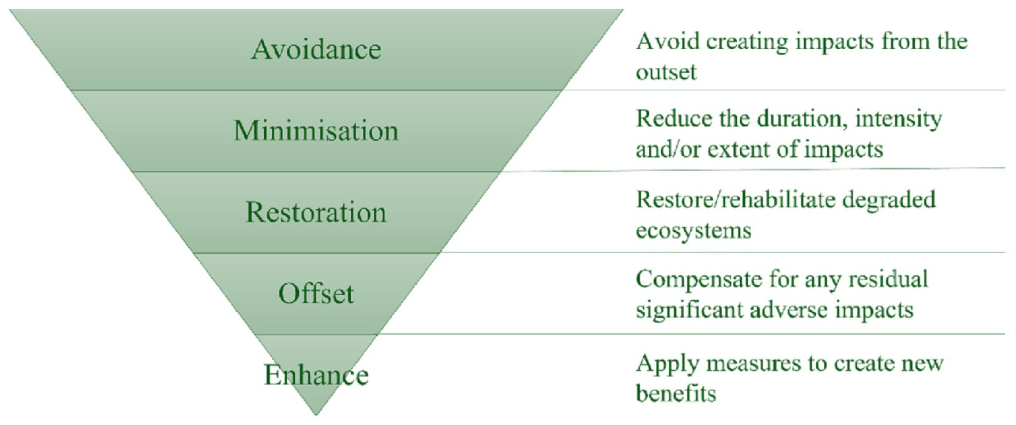
In truth, I owe a debt of gratitude to a colleague who suggested the “zero-deaths” goal for campus biodiversity recommendation. However, recently, upon delivering a lecture on the need to mitigate environmental impacts during and after the implementation of an Environmental Impact Assessment (EIA), I was reminded of the need to not only avoid any herpetofauna deaths on campus but our duty of care as environmental scientists, urban planners, and stewards of the communities where we live and work to implement the most exigent rung of the “mitigation hierarchy” (see Figure 8) proposed by Glasson and Therivel (i.e., avoid, minimize, restore, offset, and enhance), with the “enhance” rung aimed at “applying measures to create new benefits” (i.e., facilitate not only the survivability of the endangered species but to enhance their living conditions so that they can live, reproduce, and flourish as living beings) [93] (p. 2). At a minimum, the enhancement mitigation strategy ought to also include a feasibility analysis comprised of technical specifications, constraints, and costs.
This research is highly relevant to other scholars. It is one of the first studies to establish a direct link between university expansion and biodiversity reductions on campus grounds. Although earlier studies such as [94,95] have demonstrated how natural areas (e.g., patches of forest and meadows) with rich biodiversity habitats on university campus grounds in Canada and the United States have been cleared to accommodate transport infrastructure (i.e., surface parking lots and garages) and university buildings, the supposedly innovative nature of this study is expected to augment those processes by identifying a set of implications for professional practice and scholarly advancement within a “Campus as a Living Lab” philosophy, replete with research and learning opportunities for transitioning towards a more sustainable urban development [56,96].
This study makes these three research recommendations: (i) There is need to update the existing knowledge on herpetofauna populations with more ample and systematic observations and herpetofauna counts as well as more comprehensive habitat inventories and the study of wildlife behavior patterns; (ii) campus constituents and community members, such as the students in the University at Albany Liberty Partnerships Program, could become engaged with on-campus biodiversity activities more fully; and (iii) disseminating research results through various means such as media, scientific papers, and presentations at conferences could increase attention to the problem of biodiversity habitat fragmentation [2].
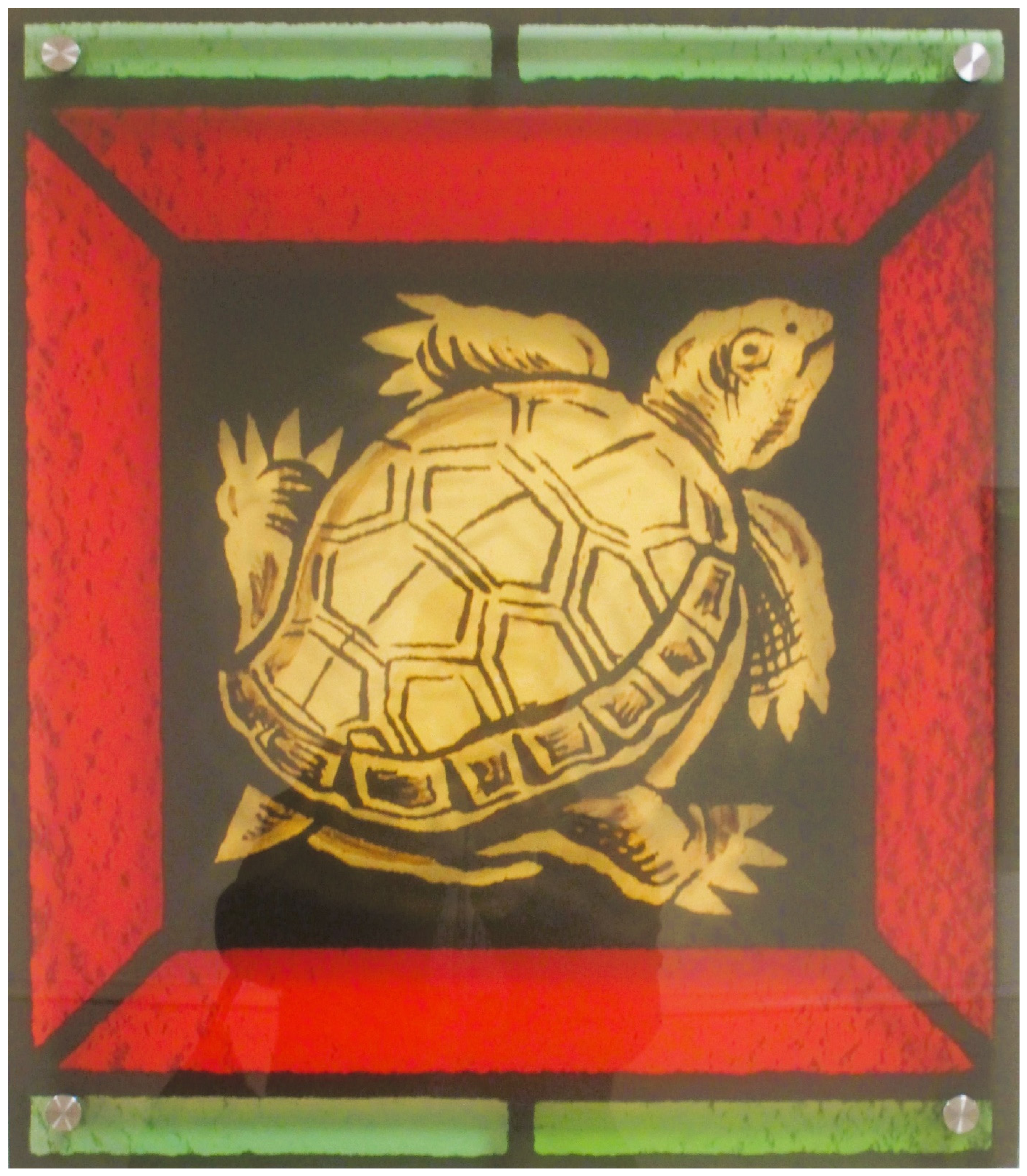
In addition, these two main management practices are recommended: (i) the implementation of various habitat mitigation measures with campus planning, and (ii) the monitorization of herpetofauna crossings in the study area by the Sustainability Program majors and minors, while maintaining the integrity of the protective measures. This set of actions is certain to create higher continuity of herpetofauna habitats in the study site, while also helping to strengthen biodiversity conservation in New York [97] (Figure 9). However, for that to happen, effective environmental advocacy as well as evidence-based research and public policy [17,98] are critically needed to find mitigations for the many harms caused not only by the growth of cities but also the thirst for knowledge and ensuing expansion of university campuses.

Funding

This research received no external funding.

Data Availability Statement

All data are in the article.

Acknowledgments

I would like to thank J. Davis, Department of Biology, J. Pipkin, Department of Geography and Planning, L. Tristan, New York State Department of Public Service, and former SUNY Chancellor K. Johnson for their early support of this research. A preliminary version of this article was presented at the 2019 Fábos Conference on Landscape and Greenway Planning at the University of Massachusetts, Amherst, 28–30 March. I thank participants there for their very insightful questions, comments, and suggestions.

Conflicts of Interest

The author declares no conflicts of interest.

Note

1
The name Indian Pond was given to the pond in the 1960s when the University at Albany was initially built due to its proximity to the Indian Quad residential halls. However, when the administration renamed the quad Indigenous Quad in 2021, Indian Pond was also renamed Parker Pond in honor of the Parkers, the first indigenous students to attend the University after its founding in 1866.

References

  1. Wakefield, S. Urbicide in the Anthropocene: Imagining Miami futures. In Imagining Apocalyptic Politics in the Anthropocene; Harper, E.T., Specht, D., Eds.; Routledge: New York, NY, USA, 2021; pp. 173–188. [Google Scholar]
  2. Walters, M.; Cen, C.; Lung, J.; Li, Y.; Lea, J.; Yeh, P. Very few scientific publications and newspaper articles focus on catastrophic events and their effects on urban wildlife. Urban Ecosyst. 2004, 27, 101–109. [Google Scholar] [CrossRef]
  3. Kolbert, E. The Sixth Extinction: An Unnatural History, 10th ed.; Henry Holt and Company: New York, NY, USA, 2024. [Google Scholar]
  4. Chiesi, L.; Forte, G. Design for Climate Change in the Neoliberal Present: Gentrification, Ecocide, and the Loss of Urbanity in New York City. Soc. Sci. 2022, 11, 451. [Google Scholar] [CrossRef]
  5. Graham, S. Lessons in urbicide. New Left Rev. 2003, 19, 63–77. [Google Scholar] [CrossRef]
  6. Graddy-Lovelace, G. Beyond Biodiversity Conservation: Why policy needs social theory, social theory needs justice, and justice needs policy. Glob. Environ. Politics 2017, 17, 144–151. [Google Scholar] [CrossRef]
  7. Wolch, J.; Emel, J. (Eds.) Animal Geographies: Place, Politics, and Identity in the Nature-Culture Borderlands; Verso: London, UK, 1998. [Google Scholar]
  8. Thrift, N. Killer Cities; Sage: Thousand Oaks, CA, USA, 2021. [Google Scholar]
  9. Boone, A.; Le Dantec, C.; DiSalvo, C. Embodied Traces: Multispecies entanglement in urban spaces. In Proceedings of the 2024 ACM Designing Interactive Systems Conference, Copenhagen, Denmark, 1–5 July 2024; ACM: New York, NY, USA, 2024; pp. 1074–1086. [Google Scholar] [CrossRef]
  10. Balsas, C. Sustainable transportation planning on college campuses. Transp. Policy 2003, 10, 35–49. [Google Scholar] [CrossRef]
  11. Balsas, C. Where does technology fit in the geospatial design and planning professions? In 5th International Conference on Connected Smart Cities 2019; Kommers, P., Peng, G., Eds.; IADIS & ISEP: Porto, Portugal, 2019; pp. 257–266. [Google Scholar]
  12. Balsas, C. Creative and sustainable Town-Gown a place triad genius loci. Environ. Space Place 2021, 13, 76–92. [Google Scholar] [CrossRef]
  13. Balsas, C. Making hidden sustainable urban planning and landscape knowledge visual and multisensorial. Land 2024, 14, 1. [Google Scholar] [CrossRef]
  14. Economist Newspaper Limited. America’s Lost Oomph. 2014. Available online: https://www.economist.com/ (accessed on 22 December 2017).
  15. Reese, L.A. Special Issue: Animals in the City. J. Urban Aff. 2022, 44, 113. [Google Scholar] [CrossRef]
  16. Shingne, M.C.; Reese, L.A. Animals in the city: Wither the human-animal divide. J. Urban Aff. 2022, 44, 114–136. [Google Scholar] [CrossRef]
  17. Mitchell, J. Animal policymaking in New York City. J. Urban Aff. 2025, 48, 1717–1730. [Google Scholar] [CrossRef]
  18. Beeri, I. Sustainable Coexistence: Interdisciplinary Perspectives on Community-Based Conservation and Human–Wildlife Encounters. 2025. Available online: https://www.mdpi.com/journal/sustainability/special_issues/KC82B37440 (accessed on 22 September 2025).
  19. Beeri, I.; Ayalon, O.; Hirsch-Matsioulas, O. Human–Animal Interactions and Sustainable Local Governance. 2024. Available online: https://www.mdpi.com/journal/sustainability/special_issues/D1839815W1 (accessed on 1 March 2026).
  20. Guthula, V.B.; Shrotriya, S.; Nigam, P.; Goyal, S.P.; Mohan, D.; Habib, B. Biodiversity significance of small habitat patches: More than half of Indian bird species are in academic campuses. Landsc. Urban Plan. 2022, 228, 104552. [Google Scholar] [CrossRef]
  21. Shen, J. Universities as financing vehicles of (sub) urbanisation: The development of university towns in Shanghai. Land Use Policy 2022, 112, 104679. [Google Scholar] [CrossRef]
  22. Molotch, H.L. The city as a growth machine: The political economy of growth. Am. J. Sociol. 1976, 84, 307–342. [Google Scholar]
  23. Logan, J.R.; Molotch, R.W. Urban Fortunes: The Political Economy of Place; University of California Press: Los Angeles, CA, USA, 2007. [Google Scholar]
  24. Ross, A. Universities and the Urban Growth Machine. Dissent, 2012. Available online: http://www.dissentmagazine.org/online_articles/universities-and-the-urban-growth-machine (accessed on 15 August 2022).
  25. Fitch, R. The Assassination of New York; Verso: London, UK, 1993. [Google Scholar]
  26. Gagné, S.A.; Bryan-Scaggs, K.; Boyer, R.H.; Xiang, W.N. Conserving biodiversity takes a plan: How planners implement ecological information for biodiversity conservation. Ambio 2020, 49, 1490–1505. [Google Scholar] [CrossRef]
  27. Hansen, G.; Macedo, J. Urban Ecology for Citizens and Planners; University Press of Florida: Gainesville, FL, USA, 2021. [Google Scholar]
  28. Grilo, C.; Borda-de-Água, L.; Beja, P.; Goolsby, E.; Soanes, K.; Roux, A.; Koroleva, E.; Ferreira, F.Z.; Gagné, S.A.; Wang, Y.; et al. Conservation threats from roadkill in the global road network. Glob. Ecol. Biogeogr. 2021, 30, 2200–2210. [Google Scholar] [CrossRef]
  29. Van Der Ree, R.; Smith, D.J.; Grilo, C. The ecological effects of linear infrastructure and traffic: Challenges and opportunities of rapid global growth. In Handbook of Road Ecology; Van Der Ree, R., Smith, D.J., Grilo, C., Eds.; John Wiley & Sons: Chichester, UK, 2015; pp. 1–9. [Google Scholar] [CrossRef]
  30. Calarco, M. Reflections on Roadkill Between Mobility Studies and Animal Studies: Altermobilities; Palgrave Macmillan: Cham, Switzerland, 2023. [Google Scholar]
  31. Donald, P. Traffication: How Cars Destroy Nature and What We Can Do About It; Pelagic Publishing: Exeter, UK, 2023. [Google Scholar]
  32. Beatley, T. The Bird-Friendly City: Creating Safe Urban Habitats; Island Press: Washington, DC, USA, 2020. [Google Scholar]
  33. Su, H.; Wang, Y.; Yang, Y.; Tao, S.; Kong, Y. An analytical framework of the factors affecting wildlife–vehicle collisions and barriers to movement. Sustainability 2023, 15, 11181. [Google Scholar] [CrossRef]
  34. Ahern, J.; Jennings, L.; Fenstermacher, B.; Warren, P.; Charney, N.; Jackson, N.; Mullin, J.; Kotval, Z.; Brena, S.; Civjan, S.; et al. Issues and methods for transdisciplinary planning of combined wildlife and pedestrian highway crossings. Transp. Res. Rec. 2009, 2123, 129–136. [Google Scholar] [CrossRef]
  35. Perrelet, K.; Moretti, M.; Dietzel, A.; Altermatt, F.; Cook, L.M. Engineering blue-green infrastructure for and with biodiversity in cities. npj Urban Sustain. 2024, 4, 27. [Google Scholar] [CrossRef]
  36. Andrews, K.; Nanjappa, P.; Riley, S.P.D. Roads and Ecological Infrastructure—Concepts and Applications for Small Animals; Johns Hopkins University Press: Baltimore, MD, USA, 2015. [Google Scholar]
  37. Van der Ree, R.; Jaeger, J.A.; Van der Grift, E.; Clevenger, A. Effects of roads and traffic on wildlife populations and landscape function: Road ecology is moving toward larger scales. Ecol. Soc. 2011, 16, art48. [Google Scholar] [CrossRef]
  38. Howell, H.J.; Seigel, R.A. The effects of road mortality on small, isolated turtle populations. J. Herpetol. 2019, 53, 39–46. [Google Scholar] [CrossRef]
  39. Myers, A.T.; Gibbs, J.P. Landscape-level factors influencing bog turtle persistence and distribution in southeastern New York State. J. Fish Wildl. Manag. 2013, 4, 255–266. [Google Scholar] [CrossRef]
  40. Fitzsimmons, M.; Breisch, A.R. Design and effectiveness of New York State’s first amphibian tunnel and its contribution to adaptive management. In Roads & Ecological Infrastructure—Concepts and Applications for Small Animals; Andrews, K., Nanjappa, P., Riley, S., Eds.; Johns Hopkins University Press: Baltimore, MD, USA, 2015; pp. 261–272. [Google Scholar]
  41. Nelson, D.; Papin, M.; Baker, T. Quick Fixes: Working Together to Address Herptile Road Mortality in New York State. Road Ecology Center, 2005. Available online: https://escholarship.org/uc/item/3sm9p1qm (accessed on 27 January 2018).
  42. Langen, T.A. Design considerations and effectiveness of fencing for turtles: Three case studies along northeastern New York State highways. In Proceedings of the International Conference on Ecology and Transportation 2011, Seattle, WA, USA, 21–25 August 2011. [Google Scholar]
  43. Lowery, T. Planning Approaches to Mitigating Habitat Fragmentation by Transportation Networks: A Case Study of Technical Solutions for the Albany Pine Bush, New York. Master’s Thesis, State University of New York, Albany, NY, USA, 2015. [Google Scholar]
  44. Hajrasouliha, A.H. Master-planning the American campus: Goals, actions, and design strategies. Urban Des. Int. 2017, 22, 363–381. [Google Scholar] [CrossRef]
  45. Dalton, L.C.; Hajrasouliha, A.H.; Riggs, W.W. State of the art in planning for college and university campuses: Site planning and beyond. J. Am. Plan. Assoc. 2018, 84, 145–161. [Google Scholar] [CrossRef]
  46. Mehaffy, M.W.; Salingaros, N.A.; Lavdas, A.A. The “Modern” Campus: Case study in (un)sustainable urbanism. Sustainability 2023, 15, 16427. [Google Scholar] [CrossRef]
  47. Brown, J.D. Biophilic laws: Planning for cities with nature. Va. Environ. Law J. 2016, 34, 52–121. [Google Scholar]
  48. Bonnie, R. Endangered species mitigation banking: Promoting recovery through habitat conservation planning under the Endangered Species Act. Sci. Total Environ. 1999, 240, 11–19. [Google Scholar] [CrossRef]
  49. Wu, L.; Ye, K.; Gong, P.; Xing, J. Perceptions of governments towards mitigating the environmental impacts of expressway construction projects: A case of China. J. Clean. Prod. 2019, 236, 117704. [Google Scholar] [CrossRef]
  50. Oh, D.Y.; Shin, H.B. University as real estate developer: Comparative perspectives from the Global East. Geoforum 2023, 144, 103764. [Google Scholar] [CrossRef]
  51. Silverman, R.M.; Lewis, J.; Patterson, K.L. William Worthy’s concept of “institutional rape” revisited: Anchor institutions and residential displacement in Buffalo, NY. Humanit. Soc. 2014, 38, 158–181. [Google Scholar] [CrossRef]
  52. Baldwin, D.L. In the Shadow of the Ivory Tower: How Universities are Plundering Our Cities; Bold Type Books: New York, NY, USA, 2021. [Google Scholar]
  53. Wijburg, G.; Waldron, R. Cities under state capitalism. Urban Stud. 2024, 62, 2154–2168. [Google Scholar] [CrossRef]
  54. Wiewel, W.; Perry, D.C. (Eds.) Global Universities and Urban Development: Case Studies and Analysis; ME Sharpe and Lincoln Institute of Land Policy: Cambridge, MA, USA, 2008. [Google Scholar]
  55. Wiewel, W.; Perry, D.C. The University as Urban Developer: Case Studies and Analysis; M.E. Sharpe: Armonk, NY, US, 2005. [Google Scholar]
  56. Colding, J.; Barthel, S. The role of university campuses in reconnecting humans to the biosphere. Sustainability 2017, 9, 2349. [Google Scholar] [CrossRef]
  57. Kim, D.; Lee, S.; Kim, S. Study of campustown projects for the sustainable win-win growth of universities and communities. Sustainability 2023, 15, 10062. [Google Scholar] [CrossRef]
  58. Farinha-Marques, P.; Lameiras, J.M.; Fernandes, C.; Silva, S.; Guilherme, F. Urban biodiversity: A review of current concepts and contributions to multidisciplinary approaches. Innov. Eur. J. Soc. Sci. Res. 2011, 24, 247–271. [Google Scholar] [CrossRef]
  59. Beeri, I.; Segev, O. Anthropocentric or Biocentric? Socio-cultural, environmental, and political drivers of urban wildlife signage preferences and sustainable coexistence. Sustainability 2025, 17, 9231. [Google Scholar] [CrossRef]
  60. Colvin, R. Community-based environment protection, citizen participation, and the Albany Pine Bush Preserve. Soc. Nat. Resour. 2002, 15, 447–454. [Google Scholar] [CrossRef]
  61. UAL. Draft Generic Environmental Impact Statement: Capital Project Plan; University at Albany: Albany, NY, USA, 2009; Available online: https://www.albany.edu/facilities/campusplanning/documents/GenericEnvironmentalImpactStatement.pdf (accessed on 16 January 2018).
  62. Ignatieva, M.; Stewart, G.H.; Meurk, C. Planning and design of ecological networks in urban areas. Landsc. Ecol. Eng. 2011, 7, 17–25. [Google Scholar] [CrossRef]
  63. Smardon, R. Sustaining the World’s Wetlands; Springer: Cham, Switzerland, 2009. [Google Scholar]
  64. Penzes, J. Sense of Place and Space—An Audit of the University at Albany Uptown Campus’ Urban Form. Master’s Thesis, State University of New York, Albany, NY, USA, 2015. [Google Scholar]
  65. Grilo, C.; Smith, D.J.; Ree, R.V.D. (Eds.) Handbook of Road Ecology; Wiley-Blackwell: Hoboken, NJ, USA, 2015. [Google Scholar]
  66. Robinson, G. (University at Albany, New York, NY, USA). Personal communication, 2018.
  67. Nelson, D. (University at Albany, New York, NY, USA). Personal communication, 2018.
  68. Mallia, M.E. University at Albany 2016 STARS Report—STARS Report 1, 2016. Available online: http://scholarsarchive.library.albany.edu/sust_starsreports/1 (accessed on 9 April 2018).
  69. Lawson, C.T.; Mallia, M.E.; Franklin, C.; Fischer, B.; Hogenkamp, D.; Ryan, M. University at Albany develops a guide to examine commuting behavior and patterns. Sustain. J. Rec. 2012, 5, 107–110. [Google Scholar] [CrossRef]
  70. Schmidt, D.H. Suburban wilderness in the Houston metropolitan landscape. J. Political Ecol. 2017, 24, 167–185. [Google Scholar] [CrossRef]
  71. Livingston, M.; Mehlem, J. Planning open spaces for biodiversity: Evaluating urban parks for wildlife habitat. Landsc. Res. 2004, 9, 162–166. [Google Scholar] [CrossRef]
  72. Pielke, R., Jr. The Honest Broker: Making Sense of Science in Policy and Politics; Cambridge University Press: Cambridge, UK, 2007. [Google Scholar]
  73. Krueger, R.; Freytag, T.; Mössner, S. Constructing Sustainable Development. In Adventures in Sustainable Urbanism; Krueger, R., Freytag, T., Mössner, S., Eds.; SUNY Press: Albany, NY, USA, 2019; pp. 1–22. [Google Scholar]
  74. Farr, D. Sustainable Urbanism: Urban Design with Nature; John Wiley & Sons: Hoboken, NY, USA, 2011. [Google Scholar]
  75. Roggema, R. The future of sustainable urbanism: A redefinition. City Territ. Archit. 2016, 3, 22. [Google Scholar] [CrossRef]
  76. Wals, A.E.; Jickling, B. ‘Sustainability’ in higher education: From doublethink and newspeak to critical thinking and meaningful learning. High. Educ. Policy 2002, 15, 121–131. [Google Scholar] [CrossRef]
  77. Heitlinger, S.; Foth, M.; Clarke, R. (Eds.) Designing More-Than-Human Smart Cities: Beyond Sustainability, Towards Cohabitation; Oxford University Press: Oxford, UK, 2024. [Google Scholar]
  78. Levy, B.L.M.; Marans, R.W. Towards a campus culture of environmental sustainability: Recommendations for a large university. Int. J. Sustain. High. Educ. 2012, 13, 365–377. [Google Scholar] [CrossRef]
  79. Hajrasouliha, A.H.; Ewing, R. Campus does matter: The relationship of student retention and degree attainment to campus design. Plann. High. Educ. 2016, 44, 30–45. [Google Scholar]
  80. Liu, J.; Wilson, M.; Hu, G.; Liu, J.; Wu, J.; Yu, M. How does habitat fragmentation affect the biodiversity and ecosystem functioning relationship? Landsc. Ecol. 2018, 33, 341–352. [Google Scholar] [CrossRef]
  81. Anonymous. What About That New Border Fence? (2y Ago). Available online: https://www.reddit.com/r/ualbany/comments/1dm9u4t/what_about_that_new_border_fence/ (accessed on 1 March 2026).
  82. Anonymous. Anyone Remember When That Pedestrian Was Killed on Washington Ave in Front of Ualbany? (3 August 2024). Available online: https://www.facebook.com/groups/456778385208869/posts/1471854317034599/ (accessed on 1 March 2026).
  83. Mohammed, A.M.S.; Ukai, T.; Hall, M. Towards a sustainable campus-city relationship: A systematic review of the literature. Reg. Sustain. 2022, 3, 53–67. [Google Scholar] [CrossRef]
  84. Cooper, J.G.; Kotval-K, Z.; Kotval, Z.; Mullin, J. University community partnerships. Humanities 2014, 3, 88–101. [Google Scholar] [CrossRef]
  85. Musikanski, L.; Allgood, B.; Hofberg, M.; Atema, K.N.; Trevan, E.; Phillips, R. Proposing a community-based wildlife conservation well-being instrument. Int. J. Community Wellbeing 2021, 4, 91–111. [Google Scholar] [CrossRef]
  86. Balsas, C. Regional Greenway Systems: A study of best practices in socio-ecological governance. In Landscape Planning: Sustainable Practices, Design and Urban Development; Unal, M., Cilek, A., Eds.; Nova Science Publishers, Inc.: Hauppauge, NY, USA, 2025. [Google Scholar]
  87. U.S. Fish & Wildlife Service. National Wetlands Inventory—Wetlands Mapper. Available online: https://fwsprimary.wim.usgs.gov/wetlands/apps/wetlands-mapper/ (accessed on 1 March 2026).
  88. Google Inc. Albany New York USA. Available online: https://www.google.com/maps/place/Albany,+NY,+USA/ (accessed on 1 March 2026).
  89. Balsas, C. Slow Down—Animal X-Ing Ahead—Summer 2025. Available online: https://cbusa06.wixsite.com/website (accessed on 1 March 2026).
  90. Jonas, A.E.G.; Wilson, D. The Urban Growth Machine: Critical Perspectives, Two Decades Later; State University of New York Press: Albany, NY, USA, 2010. [Google Scholar]
  91. Balsas, C.J. Qualitative planning philosophy and the governance of urban revitalization, a plea for cultural diversity. Urban Gov. 2022, 2, 247–258. [Google Scholar] [CrossRef]
  92. Orr, D. Dangerous Years: Climate Change, the Long Emergency, and the Way Forward; Yale University Press: New Haven, CT, USA, 2016. [Google Scholar]
  93. Cares, R.A.; Franco, A.M.; Bond, A. Investigating the implementation of the mitigation hierarchy approach in environmental impact assessment in relation to biodiversity impacts. Environ. Impact Assess. Rev. 2023, 102, 107214. [Google Scholar] [CrossRef]
  94. M’Gonigle, R.M.; Starke, J. Planet U—Sustaining the World, Reinventing the University; New Society Publishers: Gabriola Island, BC, Canada, 2006. [Google Scholar]
  95. Toor, W.; Havlick, S. Transportation and Sustainable Campus Communities: Issues, Examples, Solutions; Island Press: Washington DC, USA, 2004. [Google Scholar]
  96. Pilon, A.; Madden, J.; Tansey, J.; Metras, J. Campus as a Living Lab: Creating a culture of research and learning in sustainable development. In Teaching and Learning Strategies for Sustainable Development; Sengupta, E., Blessinger, P., Yamin, T.S., Eds.; Emerald Publishing Limited: Bingley, UK, 2020; pp. 213–227. [Google Scholar]
  97. Gilding, P. The Great Disruption: How the Climate Crisis Will Transform the Global Economy; Bloomsbury Publishing: London, UK, 2011. [Google Scholar]
  98. Akamani, K. Integrating deep ecology and adaptive governance for sustainable development: Implications for protected areas management. Sustainability 2020, 12, 5757. [Google Scholar] [CrossRef]
Figure 1. Use of herpetofauna in popular media for uses not conducive to needed conservation goals [14].
Land 15 00767 g001
Figure 2. Geo-coded wetlands on the uptown campus ecosystem. Locations 1–6 represent small wetlands on the southeast corner of the uptown campus (Environmental Protection Agency; U.S. Fish and Wildlife Service; author’s archive).
Land 15 00767 g002
Figure 3. Property developments on and around the state campuses in Albany (OpenStreetMap; photos 1–7, 9–12 taken by the author, October 2019; photo 8 taken by the author, July 2025).
Land 15 00767 g003
Figure 4. Example of a biodiversity educational plaque near Parker Pond on the University at Albany campus (author’s archive).
Land 15 00767 g004
Figure 5. (a,b) Dead turtle killed by motorized traffic on the University at Albany campus (author’s archive).
Land 15 00767 g005
Figure 6. Modal share on campus for students, staff, and faculty and City of Albany, Albany County, and the State of New York [68].
Land 15 00767 g006
Figure 7. Aerial view of the University at Albany campus [87] with a pedestrian border fence located on the northern boundary of the university campus adjacent to the major east–west arterial road Washington Avenue (and privately owned student dormitories) [88] as well as Animal X-Ing sign located adjacent to the wetlands on the southeastern corner of campus near the major east–west Western Avenue (and publicly owned student dormitory) [89].
Land 15 00767 g007
Figure 8. Environmental Impact Assessment mitigation hierarchy and duty of care [93].
Land 15 00767 g008
Figure 9. Hand-blown colored glass interpretation of a New York State turtle as part of an art installation on display at the New York State Capitol launched on the 2012 restoration of the New York State Capitol Assembly Staircase laylight (author’s archive).
Land 15 00767 g009
Table 1. Property developments on and around the state campuses in Albany (self-elaboration based on an October 2019 ground truth inventory conducted by the author—updated twice: December 2020 and July 2024).
Property
Development
Initiative/
Main Use
Completion
Date
(0) University at Albany Campus Center ExpansionsPublic—State of New York/EducationalEast add.—September 2015
West add.—September 2017
(1) College of Nanoscale Science and Engineering (CNSE) newest buildings at Fuller Road and Washington Ave ExtensionPublic—State of New York/Educational2017
(2) Student condominiumPrivate/Rental apartments2016
(3) Student condominiumPrivate/Rental apartments2018
(4) Housing development at Patroon CreekPrivate/Luxury apartments for rent2010
(5) Six-unit housing developmentPrivate/Townhomes for sale2019
(6) Emerging Technology and Entrepreneurship ComplexPublic—State of New York/Educational use2021
(7) Student dormitoryPublic/Student dormitory2012
(8) Stop the Stories campaign on Western AveCivic movementOngoing
(9) 1211 Western Ave private tower dormitoryPrivate/Apartment rentalsUnder construction
(10) New restaurants and one property remodelingPrivate/Commercial property developmentVarious completion dates, with three establishments launched in 2019
(11) New housing development at Sandridge Way and Fuller RoadPrivate/ApartmentsUnder construction as of January 2024
(12) College of Nanoscale Science and Engineering (CNSE) buildings at Fuller Road and Tricentennial DrivePublic—State of New York/Educational2009
Table 2. Synthesis of the data utilized in the study (self-elaboration based on observations conducted by the author, counts provided by student volunteers, and traffic data from official city sources).
IndicatorsMeasurements
Number of biodiversity observations—path transect
(2014–2018)
1760 est. biodiversity observations
Academic year morning period
(8:30 a.m.–10:00 a.m.)
800 est. biodiversity observations
Academic year evening period
(4:30 p.m.–7:00 p.m.)
800 evening biodiversity observations
Summer term160 est. biodiversity observations
Count data“at least 10 turtles” at a time during single visits through the Indian Pond area
2010 traffic data on Univ. Drive East before the construction of Liberty Terrace437 vehicles per hour
Traffic data on Western Avenue25,000 to 38,000 vehicles per day, depending on the time of the day and day of the week
Table 3. Particular faunistic species in Albany County [61].
Common NameScientific Name
Snapping turtleChelydra serpentina
Painted turtleChrysemys picta
Eastern garter snakeThamnophis sirtalis
Red foxVulpes vulpes
WoodchuckMarmota monax
Deer mousePeromyscus maniculatus
Little brown batMyotis lucifugus
Canada gooseBranta canadensis
Bog turtleClemmys muhlenbergii
Indiana batMyotis sodalis
Karner blue butterflyPlebejus melissa samuelis
Frosted elfinCallophrys irus
Inland barrens buckmothHemileuca maia maia
Worm snakeCarphophis amoenus
Disclaimer/Publisher’s Note: The statements, opinions and data contained in all publications are solely those of the individual author(s) and contributor(s) and not of MDPI and/or the editor(s). MDPI and/or the editor(s) disclaim responsibility for any injury to people or property resulting from any ideas, methods, instructions or products referred to in the content.