Article

An Ecosystem-Based Approach: Strategic Planning and Decision-Making in Wells Gray Provincial Park


1
Faculty of Science, Thompson Rivers University, Kamloops, BC V2C 0C8, Canada
2
Rural Livelihoods and Sustainable Communities, Department of Tourism Management and Natural Resource Science, Thompson Rivers University, Kamloops, BC V2C 0C8, Canada
*
Author to whom correspondence should be addressed.
Land 2026, 15(4), 613; https://doi.org/10.3390/land15040613
Submission received: 8 March 2026 / Revised: 5 April 2026 / Accepted: 6 April 2026 / Published: 9 April 2026
(This article belongs to the Section Land Systems and Global Change)

Abstract

Managers of protected areas (PAs) face growing challenges to conserve biodiversity while responding to multiple land uses such as recreation, tourism, and resource extraction. These pressures are intensified by the impacts of climate change on ecosystems. This highlights the need for planning approaches that support decision-making in the short, medium, and long term. This article profiles Wells Gray Provincial Park as a case study to demonstrate how an ecosystem-based planning approach can be incorporated into PAs planning. Wells Gray is situated in a unique ecosystem in the interior of British Columbia (Canada). We present an innovative model that integrates land cover types, ecosystem mapping, and Biogeoclimatic (BGC) zones derived from the Biogeoclimatic Ecosystem Classification (BEC) system using GIS tools to identify ecosystems and their associated services as Critical Decision Factors (CDFs). By explicitly linking ecosystems, land cover, and spatial patterns, this approach supports the systemic inclusion of ecosystems in management decisions. To account for future uncertainty, BGC zones were projected under climate change scenarios to inform interpretations of potential ecosystem impacts. The results indicate that this integrated analysis can initiate strategic thinking and facilitate dialogue to collaboratively plan with stakeholders. This approach can improve ecosystem-based planning processes in PAs across Canada.

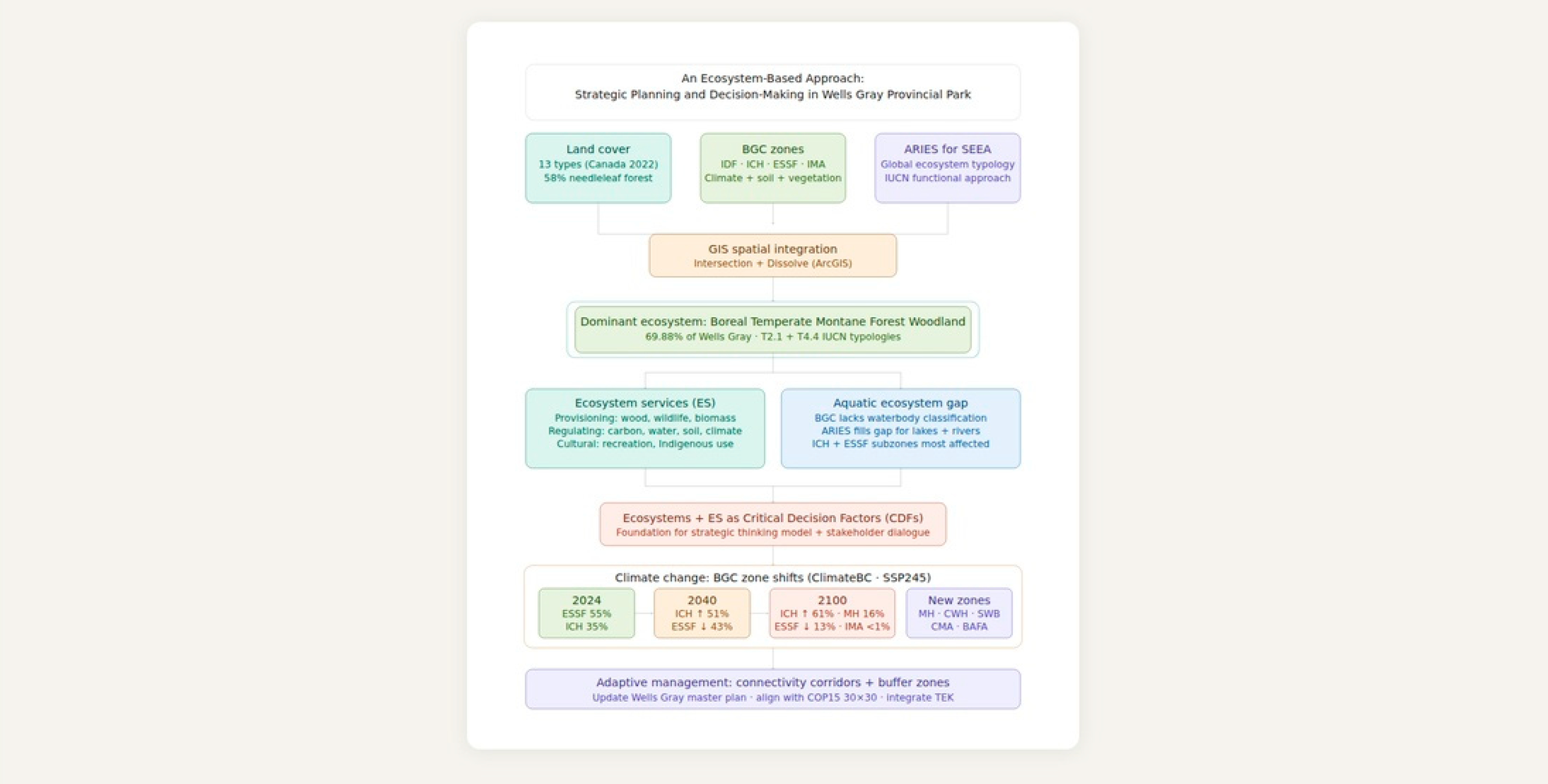
Graphical Abstract

1. Introduction

The purpose of this paper is to profile Wells Gray Provincial Park as a case study to demonstrate how an ecosystem-based approach can be incorporated to prioritize ecosystems and their services as Critical Decision Factors (CDFs). To operationalize this approach, this research draws on the CDF framework proposed by Partidário and Gomes [1], which has been applied within Strategic Environmental Assessment to support strategic decision-making under complex and uncertain conditions. Within this framework, ecosystem services (ES) can be used as CDFs to identify the ecosystem functions most relevant to policy and management outcomes. Previous studies have demonstrated that integrating ES into Strategic Environmental Assessment improves communication with decision-makers and stakeholders by making socio-ecological interactions and trade-offs more explicit [2]. The CDF framework is typically structured around three analytical stages: strategic context analysis, identification of CDFs, and scenario development. For the purposes of this research, the CDF framework was partially applied, focusing on the strategic context analysis and the identification of ESs as CDFs. Scenario development, which requires participatory workshops and sustained stakeholder engagement, was beyond the scope of this study.
Building on this partial application, we developed an innovative spatial model to support strategic thinking, facilitate stakeholder dialogue, and improve decision-making in the park’s planning processes. The model explores how ecosystem principles can inform a more effective master plan by spatially linking ecosystems, land cover types, and Biogeoclimatic Ecosystem Classification (BEC) within the park. The BEC system is the standard ecological framework used in British Columbia (BC) to classify ecosystem based on climate, soil, and vegetation relationships. Within this system, ecosystems are organized into hierarchical units known as Biogeoclimatic (BGC) zones, which represent broad geographic areas defined by similar climate conditions and dominant vegetation. In this study, BEC refers to the overall classification system, while specific ecosystem units are referred to as BGC zones. In addition, the approach illustrates how climate change may impact ecosystems and their associated ESs by incorporating future BGC change scenarios based on Intergovernmental Panel on Climate Change projections [3,4].

1.1. Policy and Conservation Context

There is a need to integrate the COP15: Kunming-Montreal Global Biodiversity Framework target (protect at least 30% of land and oceans by 2030) with other goals of the Convention on Biological Diversity [5]. This integration should focus on increasing the extent of PAs, as well as enhancing the resilience of the ecosystems that currently exist within them. Mapping ecosystems and identifying their associated risks is crucial. Moreover, establishing buffer areas to protect existing ecosystems and analyzing wildlife refugia for species as a response to climate change can significantly prevent further biodiversity loss. Consequently, it is fundamental to consider habitat heterogeneity (the structural and compositional variability of ecosystems that support species diversity), and the restoration of PAs, not only in terms of quantity but also in the quality of ecosystems and their functions [6].
According to the assessment developed by Mitchell et al. [7], most of the ES hotspots across Canada related to climate regulation, freshwater, and nature-based recreation remain outside the PA networks. This presents challenges to achieve conservation goals. Only 12% of the total area with a climate regulation ES potential, 11% of freshwater, and 11% of nature-based recreation are within PAs and other effective area-base conservation measures. While natural resource extraction economies, such as forestry, mining, oil and gas, and agriculture, cover 11% of climate regulation, 66% of freshwater, and 63% of nature-based recreation ES.
Legislation in Canada governs the ecosystem principles of natural areas through the concept of ecological integrity. The Canada National Parks Act defines ecological integrity as the natural state of a particular PA that is expected to persist over time [8]. This includes both the non-living elements and the composition and abundance of native species and biological communities, as well as natural rates of change and the ecological processes that sustain them. While zoning guidelines and indicators measure species, habitat, and resource variables, the incorporation of other factors that influence ecosystem development and behaviour must be established from the very beginning of the planning process. In this paper, we argue that adopting a dynamic functional perspective of ecosystems, rather than depending only on biogeographic or biophysical approaches [9], offers a more effective and direct way to address the challenge of conserving biodiversity and sustaining ES.
Climate change projections used in ecosystem-based planning are commonly derived from the Intergovernmental Panel on Climate Change (IPCC) assessment reports, which provide standardized future climate scenarios. In the Sixth Assessment Report (AR6) [3], these scenarios are expressed through Shared Socio-economic Pathways (SSPs) combined with Representative Concentration Pathways (RCPs) [4], allowing the exploration of alternative future climate trajectories and their implications for ecosystems and land management.

1.2. Wells Gray Provincial Park

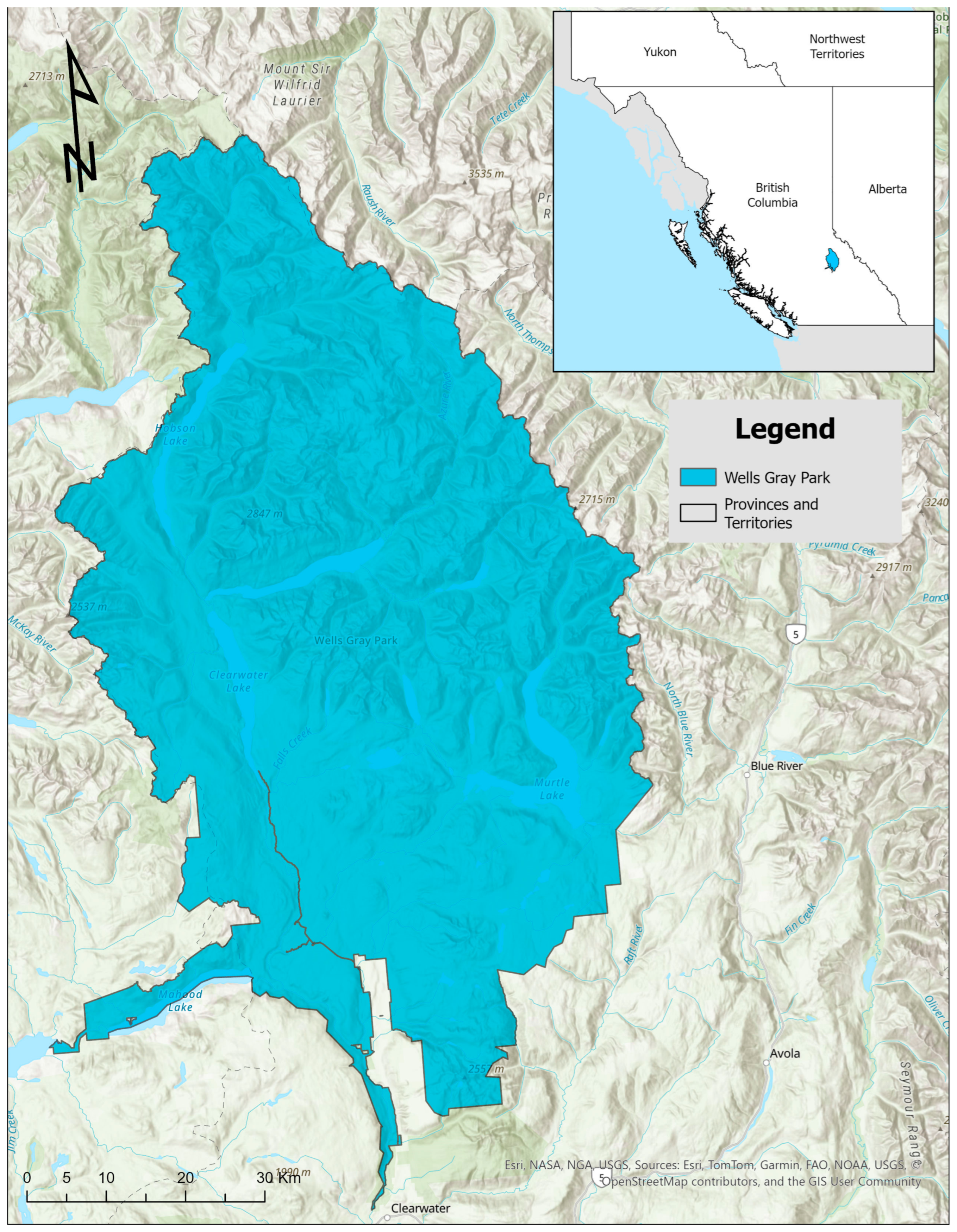
Wells Gray Provincial Park was established in 1939 and named after the Minister of Lands for British Columbia, Wellesley Gray (Figure A1). The decision to create this PA was based on considerations of tourism, hunting, fishing, waterfalls, and other natural features [10]. This area was classified as a Class A park under the Parks Act (1996), which are areas “dedicated to the preservation of their natural environment for the inspiration, use, and enjoyment of the public” [11].
Wells Gray has a total area of 5404 km2. It is located in the Thompson-Nicola and Cariboo Regional Districts of BC and belongs to the Interior Wet Belt of the province (Figure S1). The Interior Wet Belt in BC is a discontinuous region of humid forests located in the Columbia Mountains, within the Interior Cedar Hemlock Ecozone (a broad ecological region defined by similar climate, geology, and biological communities). It includes the rare Inland Temperate Rainforest, which receives heavy rainfall from Pacific weather systems rising over the mountains. The Interior Wet Belt plays a key role in carbon storage and conservation but faces threats from logging and other human activities [12]. According to BC’s Ecoregion Classification System—which stratifies the province’s ecosystems into five hierarchical levels based on physiography, climate, and broad plant and animal distributions—Wells Gray Provincial Park is majority placed in the Southern Interior Mountains ecoprovince. This classification is independent of the BEC system, which organizes ecosystems based on climate, soils, and vegetation. This ecoprovince is a broad area characterized by similar weather patterns, land shapes, and natural features [13]. Within it, Wells Gray is situated between the Northern Columbia Mountains and Columbia Highland ecoregions (Figure S2). An ecoregion is a more specific ecological unit that shares similar climate, landforms, vegetation and wildlife patterns [14]. These ecoregions are further subdivided into different ecosections, which are smaller areas defined by repeating patterns like hills, soil types, and plant communities, helping to describe the province’s ecological diversity [15]. Wells Gray Provincial Park spans three such ecosections: the Cariboo Mountains, Quesnel Highland, and Northern Shuswap Highland ecosections [13]. While this hierarchy provides a broad physiographic and climatic context, the BEC system and its BGC zones offer a more detailed, climate-vegetation-based perspective that complement the ecoregion framework.
The ecological characteristics of this area can be represented in the BEC system, developed by the Province of BC to define, describe, and map ecosystem-based units at various spatial scales. An approach that combines climate, soil, and vegetation characteristics to describe an area [16]. The BGC zones represented in Wells Gray include Interior Douglas-fir (IDF), Interior Cedar-Hemlock (ICH), Engelmann Spruce Subalpine Fir (ESSF), and Interior Mountain Heather-Alpine (IMA) as seen in Table 1. These four types are an important part of the ecosystems found in Wells Gray.
The interrelationships among the ecological characteristics of a natural area extend beyond the types of trees that inhabit it. Other living species and organisms interact with one another and with their physical environment to maintain biodiversity, and features such as climate, water bodies, and landscapes play key roles at the ecosystem and ecological levels in sustaining life. Alpine zones, for example, are known for being home for bears, deer, moose, and especially the deep-snow caribou, which is adapted to the deep snow environment that Wells Gray offers and relies on lichens found only in old-growth forests during winter [18].
Wells Gray Provincial Park represents a valuable source of biodiversity, with a wide range of ecosystems. However, it is surrounded by various land uses that pose risks to its conservation. An ecosystem-based approach recognizes that ecosystem functions and services emerge from the interaction of land cover, ecological processes, and spatial patterns. Making these relationships explicit within planning frameworks allows ecosystem considerations to be systematically incorporated into management decisions. By establishing clear connections between land cover, ecosystems, and ES, Wells Gray’s planning processes can support ecosystem functions, long-term conservation and resilience in this unique natural area.

2. Materials and Methods

2.1. Ecosystem Mapping for Wells Gray Provincial Park

The strategic analysis was conducted following the strategic thinking model proposed by Partidário [19]. This model focused on understanding the governance, planning, and management context of Wells Gray Provincial Park. CDFs were identified through an ES approach. This step operationalizes the CDFs framework by defining the ES with the greatest potential to influence strategic management outcomes within the park. The System of Environmental and Economic Accounting—Ecosystem Accounting (SEEA EA) framework was used to structure the identification of ecosystem types and associated services [20]. Spatial analysis and ES modelling were conducted using the Artificial Intelligence for Environment and Sustainability (ARIES) tool developed by k.LAB (Basalt, CO, USA) for SEEA EA applications [21,22]. This enabled the identification of ecosystem types and services present within the study area.

2.2. Ecosystem-Based Approach for Wells Gray Provincial Park

The classification of land covers and their assigned use in a region represent the complexity and dynamism of a territory. However, the changes that occur in these do not follow linear patterns, generating complex and emergent hierarchies [23]. Land cover data were provided by Natural Resources Canada, Canada Centre for Remote Sensing (Ottawa, ON, Canada) land cover classification [24], a remote sensing-based dataset that identifies surface cover types (e.g., needleleaf forest, wetland, snow and ice) independent of ecological zone designations. This differs from BGC zones and ecoregion hierarchies, which integrate climate, soil, and vegetation into interpretive ecological units.
In this study, ES were identified and treated as CDFs for spatial analysis. To operationalize this approach, links were established between ecosystems and land cover types, as well as between ecosystems and BGC zones, using spatial data for Wells Gray Provincial Park. Land cover data [24] and BEC system data [17] were mapped and analyzed using GIS software (ArcGIS Pro 3.6) [25]. The Intersect tool was applied to calculate the geometric intersection between input layers (e.g., ecosystems versus land cover, ecosystems versus BGC zones), generating output feature classes representing shared spatial extents [26]. The Dissolve tool was subsequently used to aggregate intersected features based on selected attributes [27]. This procedure enabled the grouping of land cover types and BGC zones associated with specific ecosystems, allowing assessment of which ecosystems and ES may be affected or enhanced by land-use decisions within the park.

2.3. BGC Zones Changes Due to Climate Change Scenarios for Wells Gray Provincial Park

ClimateBC_Map (Vancouver, BC, Canada) [28] was used to visualize projected changes in the BGC zones of Wells Gray Provincial Park under future climate conditions. ClimateBC_Map is a visualization interface for ClimateBC software (Version v7.60), which generates high-resolution spatial estimates of temperature, precipitation, and derived climate variables for BC using statistically downscaled global climate model outputs [29]. For this analysis, ClimateBC_Map outputs corresponding to the IPCC AR6 Shared Socio-economic Pathway (SSP245) were used [30]. This scenario represents an intermediate emissions pathway and is commonly applied in regional planning analyses. The projected BGC zone distribution used in this study are provided by ClimateBC_Map for standard climatological periods (2011-240, 2041-2070, and 2071-2100), rather than individual years. As such, 2024 was used as a baseline to represent current conditions for comparison with these future time periods. Climate variables generated by ClimateBC_Map were then used to project shifts in BGC zone distributions across the study area. The resulting spatial outputs consist of projected BGC classifications under the SSP245 scenario for each time period. These projections were used to assess potential changes in ecosystem distributions within Wells Gray Provincial Park and to inform the development of planning scenarios relevant to ecosystem-based management.

3. Results

3.1. Shaping Future Management Approaches for Wells Gray

The exercise that follows demonstrates how the ecosystems and ES within Wells Gray can become CDFs. These CDFs can serve as the starting point for a strategic thinking model that promotes stakeholder dialogue and facilitates decision-making. This will provide a more comprehensive and combined assessment of the socio-ecological system that Wells Gray represents for the province of BC [2,19].

3.1.1. The Ecosystems and Ecosystem Services of Wells Gray

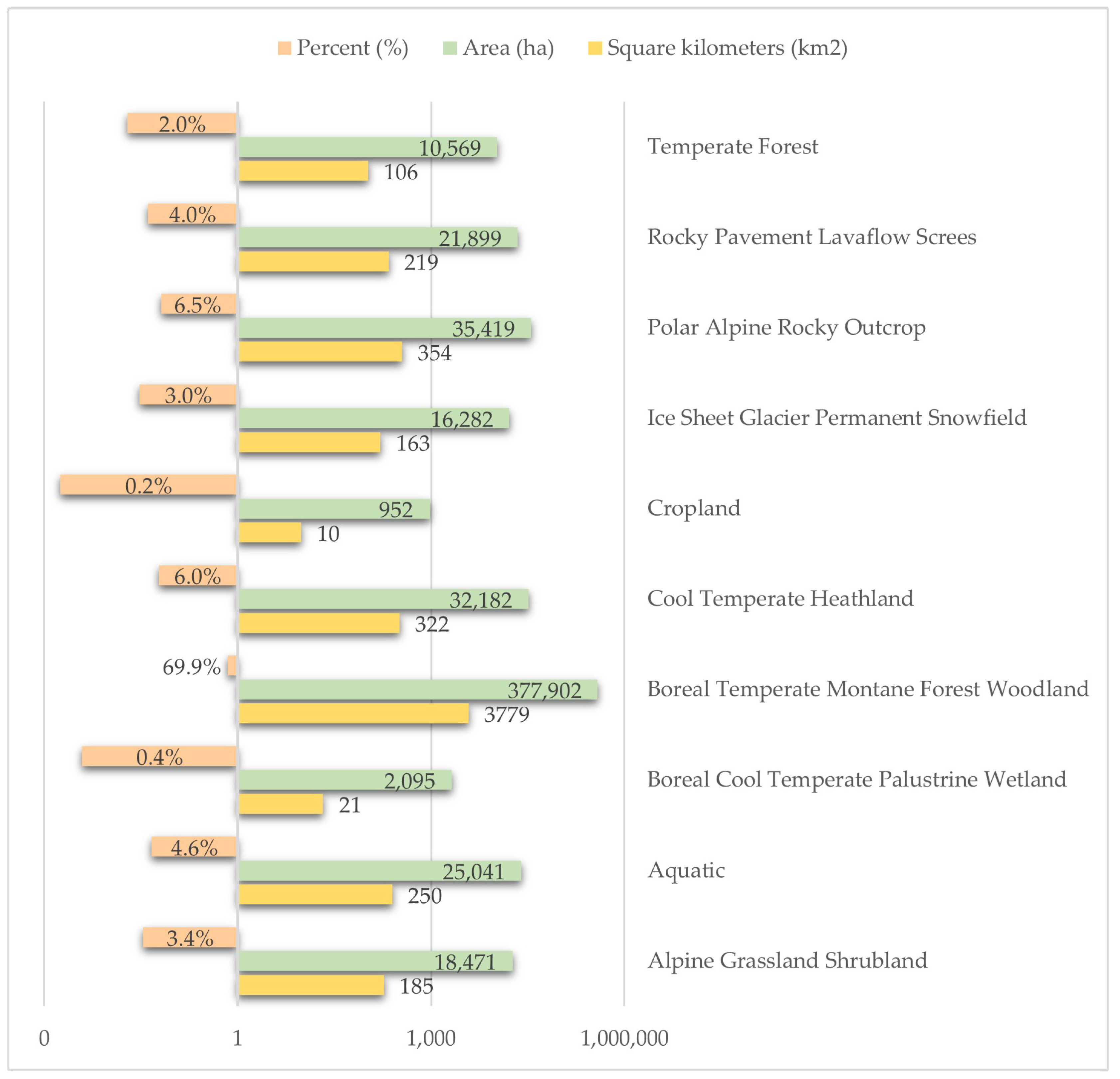
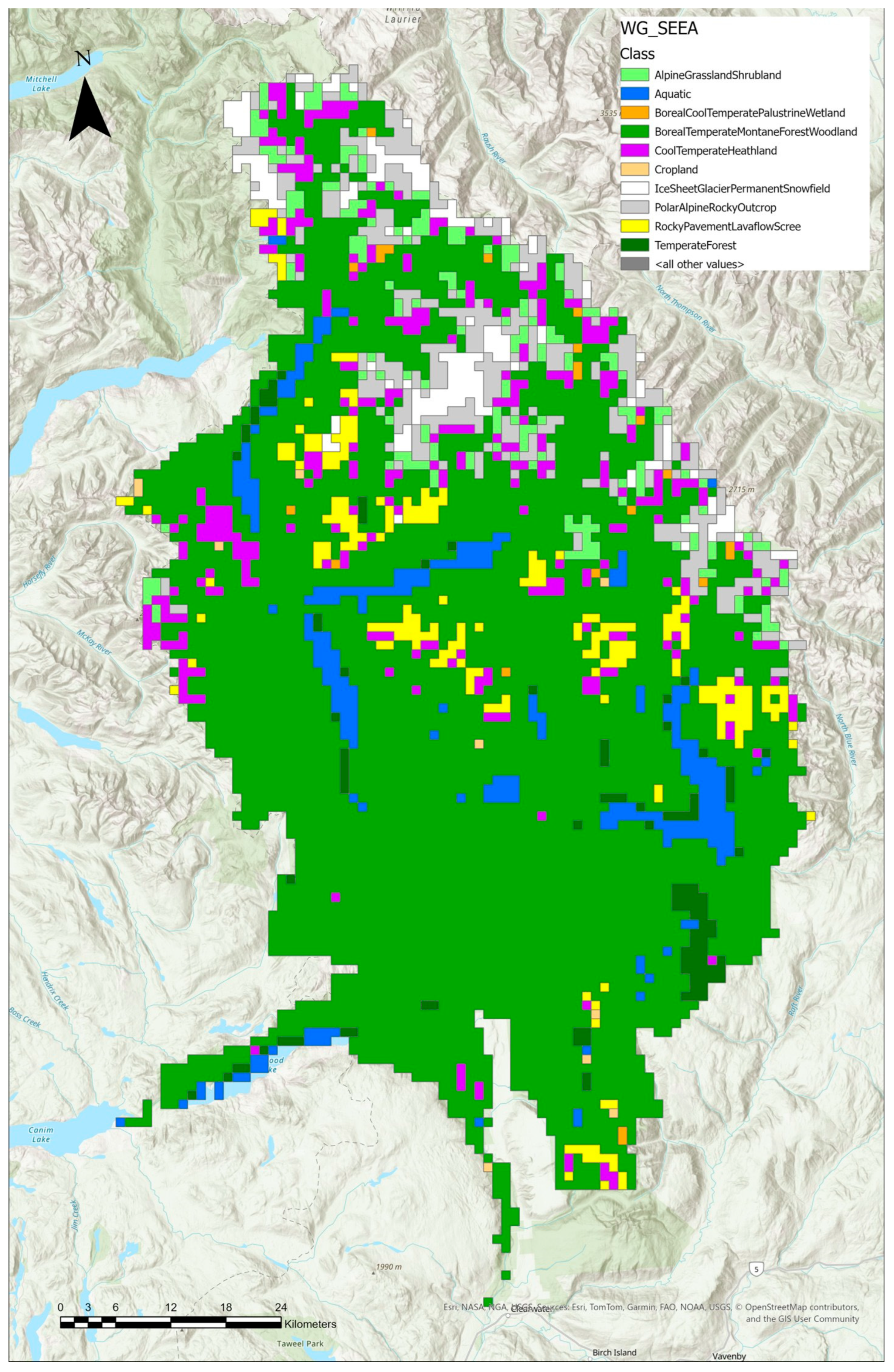
Using the ARIES for SEEA Explorer [21,22], the ecosystems in Wells Gray Provincial Park were assessed (Figure A2). ARIES for SEEA uses the IUCN Global Ecosystem Typology [31], a classification framework for Earth’s ecosystems that integrates their functional and compositional characteristics. The main ecosystem type in Wells Gray is Boreal Temperate Montane Forest Woodland (Figure 1), which is the equivalent of T2.1 Boreal and Temperate High Montane Forests and Woodlands, and T4.4 Temperate Woodlands in the IUCN Global Ecosystem Typology (Table S1). The ES were identified and classified following the SEEA EA reference list of final and intermediate ecosystem services [31], as operationalized through the ARIES for SEEA platform for Wells Gray Provincial Park. This ecosystem covers 69.88% of the PA and supports a variety of species, including fungi, mosses, liverworts, herbivores such as caribou, bears, and deer, as well as insects and omnivores like moose [31]. This ecosystem type provides a variety of provisioning ES, including wood, wildlife, plants, and other biomass. It also offers cultural ES, such as recreation, visual amenity, education, scientific research, and services tied to Indigenous use, such as traditional hunting, gathering, and spiritual practices. This ecosystem also contributes significantly to regulating ES, such as global climate, precipitation patterns, air filtration, soil and sediment retention, pollination, nursery services, and habitat maintenance [20].
Wells Gray Ecosystems and Ecosystem Services Interconnection: Ecosystems Links to Land Cover Features
With ecosystems and the ES identified, it is imperative to link these to land cover features and BGC zones classification in order to understand how decisions regarding the use of these features affect or support the ecosystems and their associated services. Land cover represents a detailed map of the physical characteristics of the earth’s surface, including vegetation, water, soil and urban spaces. Changes in land cover features can be influenced by climate drivers or human actions. Land cover is used to define specific practices of land uses (such as recreational activities), but some land uses (like resource extraction activities) can also influence land cover aspects [32]. These changes can contribute to the loss of natural areas that affect the environment, the population of wildlife species and the ES that flow from these landscapes [33].
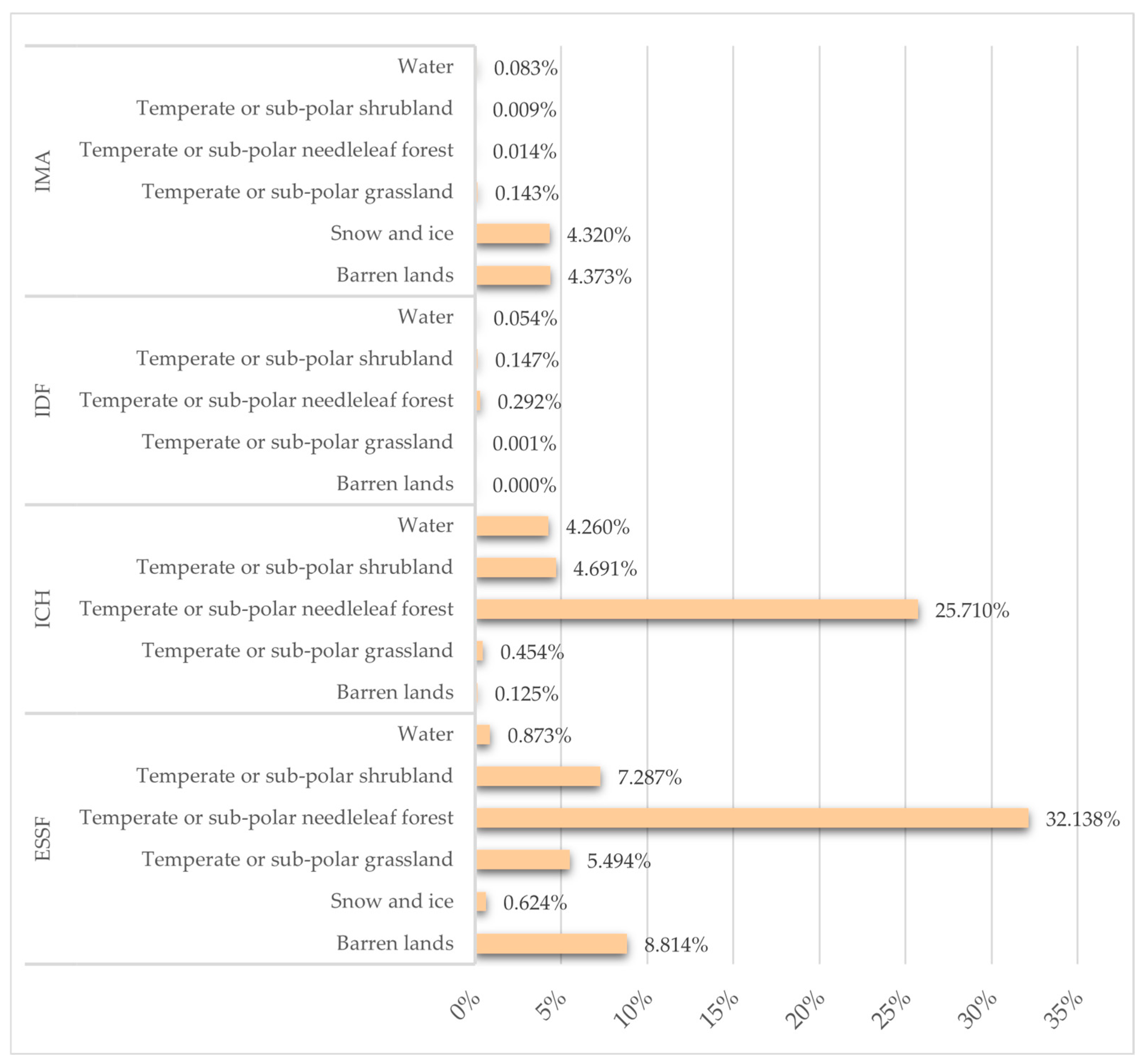
According to the land cover classification for Canada [24], Wells Gray Provincial Park entails 13 types of land covers. However, Temperate or Sub-polar Needleleaf Forest is the principal land cover that represents the area as it covers 58.054% of the park. This is followed by Barren Lands (13.29%), Temperate or Sub-polar Shrubland (12.06%), Temperate or Sub-polar Grassland (6.10%), Water (5.26%) and Snow and Ice (5.11%).
The intersection of Wells Gray land cover with ecosystem types (Table S2) demonstrates that areas classified as Temperate or Sub-polar Needleleaf Forest mainly align with Boreal Temperate Montane Forest Woodland (52.43%), Cool Temperate Heathland (1.35%), and Temperate Forest (1.28%). These intersections highlight the ecological diversity within Wells Gray Provincial Park and emphasize the importance of recognizing how different land cover types correspond with specific ecosystem types (Table S2). This insight provides a valuable foundation for more informed ecosystem-based planning and conservation strategies within the park. Recognizing the environmental changes driven by human actions, including climate change, can provide valuable guidance for adaptation and resilience strategies [34]. The land cover classification of Wells Gray must align with the ecosystems in the area to develop management practices that support ecosystem health and ensure the flow of the services they provide. Ecosystems extend beyond land cover classifications due to the interactions between vegetation, soil, and climate. Managing the area only based on land cover classification does not fully capture the dynamics at play. Therefore, linking land cover with ecosystems helps to establish more effective management actions.
Linking Ecosystems to BGC Zones
Since BC’s BEC system classification divides the province into ecosystem-based units that incorporate climate, soil, and vegetation characteristics, it offers a more ecologically accurate framework for relating Wells Gray’s ecosystem types than the broader land cover classification. As noted, the ecosystem types used in this study were developed from a global-scale model, which lacks the regional specificity provided by the BEC system. Therefore, this research presents only an approximation of how these ecosystem types correspond to BGC zones. Nevertheless, while the BEC system provides a more ecologically grounded perspective, the land cover data remains useful for understanding surface-level patterns and supporting complementary spatial analyses.
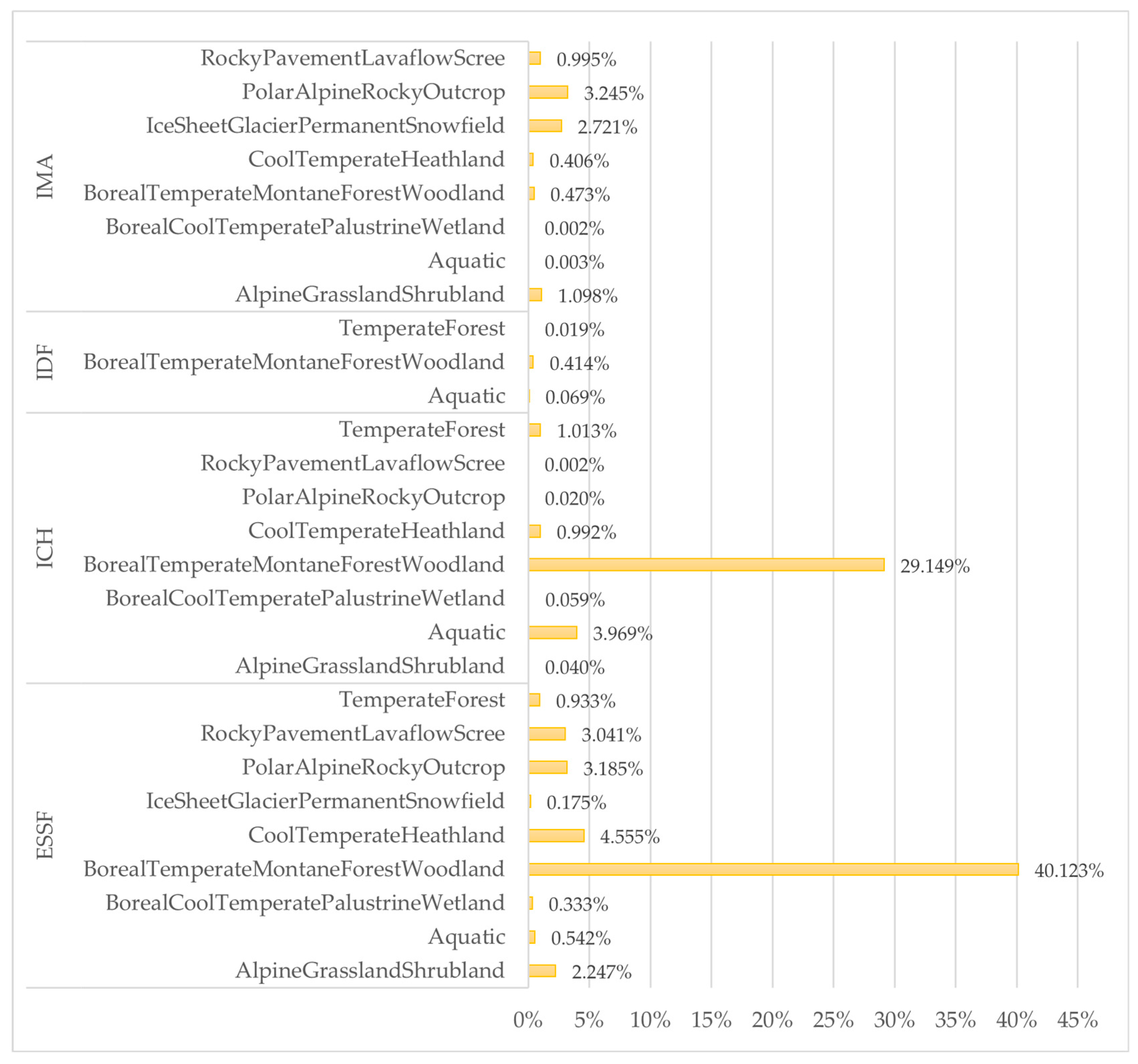
The intersection suggests that the Wells Gray BGC zones and ecosystem types derived from ARIES for SEEA show clear overlaps (Figure 2), but the alignment varies across different BGC zones. It is relevant to note that the BGC zones do not account for aquatic ecosystems or waterbodies. Graphical analysis shows that the lakes and main rivers in Wells Gray primarily align with subzones of the ICH zone, specifically Moist Warm (ICHmw), Wet Cool (ICHwk), and Very Wet Cool (ICHvk). To a lesser extent, they also correspond with subzones of the ESSF zone (Wet Cool ESSFwk and Wet Cold ESSFwc) and the IDF zone (Moist Warm IDFmw). As a result, certain areas within the ICH, ESSF, and IDF subzones align with the Aquatic ecosystem type. This indicates that while the BEC system offers strong ecological detail for terrestrial ecosystems, it lacks specificity for aquatic environments. Consequently, integrating ecosystem classifications like those from ARIES for SEEA can help fill this gap, to provide a more comprehensive interpretation of ecosystem distribution, especially in relation to freshwater features within Wells Gray.
Ecosystems and Ecosystem Services Link to Land Cover and BGC Zones
The variation in alignment between ecosystem types, land covers, and BGC zones emphasizes the need for a clear and adapted approach to recognizing ecosystem functions and management within each specific zone of the park. Still, this exercise is valuable for identifying which land covers and BGC zones correlate with ecosystem types, helping to assume the ES associated with each classification (Figure 3).

3.1.2. Wells Gray and Climate Change

The BGC zone levels for Wells Gray Provincial Park have four main classifications (Table 1). In these BGC zones, the climate interacts with land surface materials to create particular environments suitable for the development of specific plant and animal communities [17].
  • The lower to mid slopes of Wells Gray form the ICH. The zone has a cool to warm temperate temperature. Whereas summers are warm and dry, winters are cool and wet. Though drier than the interior subalpine (like ESSF) zone, the ICH zone is the wettest of the interior montane zones (like IDF) and boreal montane zones. This zone has a variety of coniferous trees.
  • The middle and high slopes of the mountains of Wells Gray are covered in ESSF. This zone has a subalpine boreal climate. The summers are cool and short, and the winters are long and cold. In the forested subzones, precipitation and snowfall level are higher. Only trees that can tolerate long frozen seasons are able to grow here.
  • The tops of mountains of Wells Gray define IMA. The temperature is cold, with high levels of snowfall and wind. The winters are long, and the growing season is short. It is dominated by mosses and lichens, and it is essentially treeless; however, some patches of trees with meadows are present.
  • IDF sporadically appears in the main valley of Wells Gray. It is considered the second warmest zone. Summers are dry and under moisture stress. Winters are cool and have low snowfalls.
The current BEC system in Wells Gray Provincial Park reflects long-term interactions among climate, soil, and plant and animal communities. Within this system, ecosystems are organized into BGC zones, such as ICH and ESSF. Climate change is expected to alter temperature and moisture regimes, which will shift these ecological relationships Table 2. As a result, the distribution of BGC zones within the park is projected to change by 2040 and 2100 [28,29]. For example, warmer-adapted zones like ICH are expected to expand, while colder, higher-elevation zones such as ESSF and IMA are projected to decline. These changes indicate that while the BEC framework remains the same, the spatial extent and composition of its BGC units will shift over time, reflecting changing environmental conditions.
According to Demarchi [13], the Mountain Hemlock (MH) zone is classified as a subalpine boreal climate, characterized by short, cool summers and cool, wet winters with deep seasonal snow accumulation. The ESSF zone, its continental equivalent, experiences colder, drier winters and has a shorter growing season. Among the three subalpine boreal zones in BC, the Spruce–Willow–Birch (SWB) zone has the coldest climate and is considered the coldest forested zone in the province, with long, cold winters and extremely short, cool summers. The Coastal Western Hemlock (CWH) zone has a more moderate climate, featuring cool summers and mild, wetter winters compared to the ICH zone. At higher elevations, the Alpine Tundra (AT) zone appears as Costal Mountain Heather Alpine (CMA), which has the snowiest conditions, followed by IMA and Boreal Altai Fescue Alpine (BAFA), which is the driest. Overall, the AT zone is characterized by a severe climate, with a mean annual temperature of −1.9 °C. Extreme cold, in addition to the absence of a warm season and a very short frost-free period, limits tree growth.
The expansion of the ICH zone to higher elevations of ESSF may indicate that these areas tend to be less cold and humid, so they could become warmer and drier than they are today. The extension of the CWH zone into higher elevations previously classified as IMA suggests a shift toward more precipitation falling as rain rather than snow. This indicates a warmer climate that is wetter in some senses but generally drier compared to historical conditions. Winters in Wells Gray will likely be cold but short, with less snow than today and only on the highest peaks. Summers will be warm, dry, and longer, especially in the Clearwater Valley, with a growing season experiencing soil moisture deficits.
These BGC zones illustrate the wide climatic variation across elevation gradients in Wells Gray, where subalpine and alpine zones currently experience colder temperatures and shorter growing seasons. The characteristics of zones like MH, ESSF, and SWB reflect a shift from cool, wet conditions to more extreme cold and dryness, while zones like CWH and AT illustrate how changes in temperature and moisture levels may shape vegetation and ecosystem dynamics. Overall, these trends highlight the vulnerability of these ecosystems to climate change, especially due to rising temperatures, reduced snowpack, and altered precipitation patterns.

4. Discussion

4.1. Ecosystems and Their Link to Land Cover and BGC Zones

To preserve the quantity (area) and quality (biodiversity) of natural ecosystems it is necessary to maintain the functional diversity of ecosystems and the services that flow from them [35]. For that reason, it is required to identify their ecological processes and ecosystem functions. In addition, knowing the role they play in the environment and the factors that enhance or limit their development is crucial [9].
The ecosystem properties of the ecosystem types T2.1 Boreal and Temperate High Montane Forests and Woodlands and T4.4 Temperate Woodlands, represent most of the area of Wells Gray [31]:
  • T2.1: The growth and reproduction of the species is seasonal; hence, it is limited. There are also winter dormancy and hibernation, as well as migration and the forest-tolerated frost environment.
  • T4.4: High seasonal diversity and low endemism of plants support a complex trophic network of invertebrate and vertebrate consumers, like large herbivores and their predators, which regulate the chain. There is also a fire- and seasonal drought-tolerant environment.
These ecosystem properties and functions are significant for guiding potential actions and land uses in this area. If the management plan incorporates these properties into its core strategies, the ecosystem’s functions can be sustained, and its properties will persist. Additionally, the supply of ES will continue, as their provision depends on the ecosystem’s capacity and the flow of ecological processes [36]. Moreover, several land uses, along with environmental and economic factors, affect the frequency and severity of impacts on land cover features. For example, resource extraction or human overuse of recreational areas can impact the availability of clean water and disrupt the migration of wild species. In addition, these activities can affect agricultural and forestry production. Effective land cover planning depends on detailed knowledge of surface characteristics, including the boundaries that define different land cover types and how these change over time. A clear understanding of the significance of ecosystems and their land cover characteristics will enable the creation of appropriate management strategies. These strategies will support resource extraction and other human activities while ensuring the proper functioning of the ecosystems.
The approach to know how ecosystems and ES are distributed within Wells Gray Provincial Park is provided in the Supplementary Materials (Table S3). For example, recognizing the importance of the Boreal Temperate Montane Forest Woodland ecosystem highlights its biodiversity, carbon storage capacity, and economic and cultural value. This ecosystem provides valuable habitat for a wide range of species and supports human communities through timber production, tourism, and traditional practices. These traditional practices refer to long-established land-use, cultural, and livelihood activities that are passed on across generations and are closely tied to ecosystem functions and local ecological knowledge [37]. Planning and management actions for the park should take this value into account, incorporating targeted efforts to protect and improve the ecosystem. At the same time, additional analysis and more detailed ecosystem mapping are needed to better understand the functions of ecosystems throughout the park.
To improve management directions in the Wells Gray Provincial Park master plan, it is necessary to incorporate and align ecosystem principles with the park’s values and mission. This will require significant revision of the master plan and the involvement of stakeholders, park managers, and environmental professionals. Planning opportunities can emerge from identifying the ecosystems, ES, and their links to land cover features, BGC zones and associated changes. This strategy can be the first step to achieve an ecosystem-based approach for this park and guide the beginning of actions to update and improve its master plan.

4.2. Wells Gray and Climate Change

The BEC system in Wells Gray Provincial Park will change by 2040 and 2100 and the ecosystems will change progressively and adapt to the new conditions. The type of tree species that will emerge here will attract different wildlife and will change conditions for other types of wildlife that right now inhabit the area. This will displace some flora and fauna and simultaneously be a refuge for others. According to MacKenzie & Mahony [38], there is already evidence of changes in forest ecosystems in BC, from variances in growth rates, health, and mortality to changes in the distribution range in regard to climate conditions that are suitable for specific tree species. Other environmental stressors may also increase, such as wildfires, windstorms, and outbreaks of insects or pathogens. These have already become more frequent in BC due to climate change conditions, placing additional pressure on existing ecosystems [39]. The projected shifts in BGC zones provide a basis for exploring planning scenarios that prioritize the maintenance of ecosystem functions and ES under changing climatic conditions.

4.3. Limitations of the Study and Future Research

The information used to establish the ecosystems came from ARIES for SEEA, which is a recognized tool for compiling natural capital for any location on earth. However, the scale of analysis is global, and the land cover features and BGC zones have a regional applicability. Making links between the ecosystems, land covers, and BGC zones was a significant task. For the research and the case study, the approach to establish which ecosystems inform the CDFs for management decisions, especially in the climate scenarios generated by ClimateBC_Map, was a foundational step. While detailed ecosystem mapping is needed to update and improve the Wells Gray master plan, applying the ecosystem principles defined in this project can help PA management balance conservation, recreation, and climate resilience goals.
Although this study uses the CDFs approach to identify key ecosystems in the planning process of Wells Gray, it is crucial to understand that this strategy does not capture the wider ideas suggested in the research. Delivering a decision-making process that focuses only on CDFs might prioritize certain ecological functions or land features while ignoring the important social and ecological values found in Indigenous and local knowledge. Future studies could explore the potential to redefine CDFs to align with these values. For instance, a collaboration with Indigenous communities to co-develop indicators or implement planning strategies that do not separate ecological, cultural, and governance functions. Importantly, this would lead to a more inclusive and effective conservation outcome.
Further research is also needed to evaluate the potential of BC’s PA network, especially its contributions to Canada’s conservation targets. Particular attention should be paid to the Interior Wet Belt, where many areas with high biodiversity currently lack formal protection status. An assessment by DellaSala et al. [40] established this region as endangered, with logging representing 57% of human disturbance. Essential biotic elements such as Old-Growth Birds, Southern Woodland Caribou, Sensitive Fish, and Old-Growth Lichen habitats were identified as vulnerable to critically endangered.
In addition to the conservation values of Wells Gray, contiguous areas in the Interior Wet Belt provide essential ES, including climate regulation, freshwater supply, and nature-based recreation [7]. This PA and the parts of the Interior Wet Belt that are not protected require urgent attention from researchers, decision-makers, and activists to establish buffer zones and ecological corridors that build a connected network of PAs. This network will potentially maintain important ecosystem functions and protect biodiversity at a broader scale.

5. Conclusions

This paper focused on demonstrating how an ecosystem-based approach can prioritize ecosystems and their services as CDFs within Wells Gray Provincial Park. The novelty of this study lies in integrating ES, land cover types, and BGC zones within a single spatial model to inform strategic decision-making. Unlike previous studies that rely solely on biogeographic or biophysical classifications, our approach explicitly links ecosystems, their functions, and climate change projections. This study demonstrates that applying the SEEA EA typology to a site-specific scale is feasible and produces actionable ES-ecosystem linkages, even when the tool was designed for global-scale analysis. Furthermore, BGC zone modelling under climate scenarios reveals that Wells Gray will experience significant biome displacement, highlighting the need for proactive rather than reactive master plan revisions. Together, these findings shift the conversation from “what should we protect?” to “what planning tools can help us protect it effectively?”. Importantly, this provides a practical tool for adaptive management and an approach that can be applied to other PAs.
This approach also emphasizes the potential impacts of climate change on ecosystems and their services, to establish the need for adaptive management strategies. Using ecosystems as the foundation for planning can justify decision-making based on ecological evidence [41].
This paper mapped the interconnectedness of ecological features within the park by innovatively combining information on ecosystems, land cover types, and BGC zones. The Boreal Temperate Montane Forest Woodland ecosystem is the most representative ecosystem in Wells Gray. Considering that Canada’s boreal forest represents 28% of the world’s boreal zone and plays a key role in carbon storage, biodiversity, and cultural values [42], strategic decision-making within this ecosystem becomes imperative. Recognizing this ecosystem and its services as CDFs in the management of Wells Gray will support regional ecological integrity and climate resilience while also aligning with national and international conservation targets.
The analysis also demonstrated that looking at ecosystems from a more dynamic and functional perspective, instead of using only biogeographic or biophysical classifications such as land cover and BEC systems, provides a more practical way to conserve biodiversity and sustain ESs. Despite land cover, BGC zones and ecosystem service-functional units did not always align perfectly in their spatial boundaries or categorical groupings, this exercise illustrated the value of using a combined, integrative approach to inform management decisions within Wells Gray. Although each system has its limitations, the correlations between them provide valuable information that can support planning and ecologically informed conservation actions.

Supplementary Materials

The following supporting information can be downloaded at: https://www.mdpi.com/article/10.3390/land15040613/s1, Figure S1: British Columbia Regional Districts and Interior Wet Belt, Figure S2: Wells Gray Ecoregions and Ecosections, Table S1: ARIES for SEEA and the IUCN Global Ecosystem Typology, Table S2: Wells Gray Land Covers and Ecosystems Type Intersection, Table S3: Wells Gray BGC zones, Ecosystems and Ecosystem Services approached.

Author Contributions

Conceptualization, A.P. and C.W.M.; methodology, A.P. and C.W.M.; software, A.P.; validation, A.P. and C.W.M.; formal analysis, A.P. and C.W.M.; investigation, A.P.; resources, A.P. and C.W.M.; data curation, A.P.; writing—original draft preparation, A.P.; writing—review and editing, A.P. and C.W.M.; visualization, A.P.; supervision, C.W.M.; project ad-ministration, A.P. and C.W.M.; funding acquisition, C.W.M. All authors have read and agreed to the published version of the manuscript.

Funding

This research was supported by the Canadian Mountain Network Grant (1141832), Braiding Knowledge Canada Grant (104154) and Blair Climate Change Research Initiative Fund (Thompson Rivers University) (104153).

Data Availability Statement

The original contributions presented in this study are included in the Supplementary Materials. Further inquiries can be directed to the corresponding author.

Acknowledgments

We would also like to acknowledge the editing and formatting of Jordyn Bogetti and Rosa Catalina Valle.

Conflicts of Interest

The authors declare no conflicts of interest.

Appendix A

Figure A1. Wells Gray Provincial Park.
Land 15 00613 g0a1

Appendix B

Figure A2. Wells Gray Provincial Park Ecosystem type ARIES for SEEA Explorer [21,22].
Land 15 00613 g0a2

References

  1. Partidario, M.R.; Gomes, R.C. Ecosystem Services Inclusive Strategic Environmental Assessment. Environ. Impact Assess. Rev. 2013, 40, 36–46. [Google Scholar] [CrossRef] [Scilit]
  2. Geneletti, D. A Conceptual Approach to Promote the Integration of Ecosystem Services in Strategic Environmental Assessment. J. Env. Assmt. Pol. Mgmt. 2015, 17, 1550035. [Google Scholar] [CrossRef] [Scilit]
  3. AR6 Synthesis Report: Climate Change 2023. Available online: https://www.ipcc.ch/report/ar6/syr/ (accessed on 14 June 2025).
  4. Hausfather, Z. Explainer: How ‘Shared Socioeconomic Pathways’ Explore Future Climate Change. Available online: https://www.carbonbrief.org/explainer-how-shared-socioeconomic-pathways-explore-future-climate-change/ (accessed on 10 May 2025).
  5. COP15: Final Text of Kunming-Montreal Global Biodiversity Framework. Available online: https://www.cbd.int/article/cop15-final-text-kunming-montreal-gbf-221222 (accessed on 9 April 2025).
  6. Weiskopf, S.R.; Isbell, F.; Arce-Plata, M.I.; Di Marco, M.; Harfoot, M.; Johnson, J.; Lerman, S.B.; Miller, B.W.; Morelli, T.L.; Mori, A.S.; et al. Biodiversity Loss Reduces Global Terrestrial Carbon Storage. Nat. Commun. 2024, 15, 4354. [Google Scholar] [CrossRef] [Scilit] [PubMed]
  7. Mitchell, M.G.E.; Schuster, R.; Jacob, A.L.; Hanna, D.E.L.; Dallaire, C.O.; Raudsepp-Hearne, C.; Bennett, E.M.; Lehner, B.; Chan, K.M.A. Identifying Key Ecosystem Service Providing Areas to Inform National-Scale Conservation Planning. Environ. Res. Lett. 2021, 16, 014038. [Google Scholar] [CrossRef] [Scilit]
  8. Canada National Parks Act, S.C. 2000, c. 32; Government of Canada: Ottawa, ON, Canada, 2000.
  9. Keith, D.A.; Ferrer-Paris, J.R.; Nicholson, E.; Bishop, M.J.; Polidoro, B.A.; Ramirez-Llodra, E.; Tozer, M.G.; Nel, J.L.; Mac Nally, R.; Gregr, E.J.; et al. A Function-Based Typology for Earth’s Ecosystems. Nature 2022, 610, 513–518. [Google Scholar] [CrossRef] [Scilit] [PubMed]
  10. Ministry of Lands, Parks & Housing, Parks & Outdoor Recreation Division. Wells Gray Park Master Plan; Government of British Columbia: Victoria, BC, Canada, 1986. Available online: https://nrs.objectstore.gov.bc.ca/kuwyyf/wells_gray_pk_mp_19860201_4cb7dced9a.pdf (accessed on 10 March 2025).
  11. Park Act. Available online: https://www.bclaws.gov.bc.ca/civix/document/id/complete/statreg/96344_01 (accessed on 14 February 2025).
  12. Parks Canada Agency, Government of Canada. Old Growth Inland Rainforest. Available online: https://parks.canada.ca/pn-np/bc/revelstoke/nature/chaine-columbia-range/pluviale-rainforest (accessed on 9 January 2025).
  13. Government of British Columbia. An Introduction to the Ecoregions of British Columbia, 3rd ed.; Province of British Columbia, Ministry of Environment: Victoria, BC, Canada, 2011. Available online: https://www2.gov.bc.ca/assets/gov/environment/plants-animals-and-ecosystems/ecosystems/broad-ecosystem/an_introduction_to_the_ecoregions_of_british_columbia.pdf (accessed on 8 February 2025).
  14. Canada Ecoregions|Data Basin. Available online: https://databasin.org/datasets/6dfe01568b844a5c84549670552221b2/ (accessed on 8 June 2025).
  15. Government of British Columbia. Ecosections—Ecoregion Ecosystem Classification of British Columbia-Open Government Portal. Available online: https://open.canada.ca/data/en/dataset/ccc01f43-860d-4583-8ba4-e72d8379441e (accessed on 6 April 2025).
  16. Government of British Columbia. Biogeoclimatic Ecosystem Classification (BEC) System: How the System Works; Province of British Columbia, Ministry of Forests: Victoria, BC, Canada. Available online: https://www.for.gov.bc.ca/hre/becweb/system/how/index.html (accessed on 6 May 2025).
  17. Government of British Columbia. Biogeoclimatic Ecosystem Classification (BEC) Map [Data Set]; BC Data Catalogue: Victoria, BC, Canada, created 4 February 2021; last updated 24 June 2022. Available online: https://catalogue.data.gov.bc.ca/dataset/bec-map/resource/46ceb84a-3f6d-436c-b4c1-c89beb72d11a (accessed on 6 May 2025).
  18. Environment Canada. Recovery Strategy for the Woodland Caribou, Southern Mountain Population (Rangifer Tarandus Caribou) in Canada; Species at Risk Act recovery strategy series; Environnement Canada: Gatineau, QC, Canada, 2014.
  19. Partidário, M.R. Strategic Environmental Assessment Better Practice Guide Methodological Guidance for Strategic Thinking in SEA; Portuguese Environment Agency and Redes Energéticas Nacionais (REN), SA: Lisbon, Portugal, 2012. [Google Scholar]
  20. King, S.; Agra, R.; Zolyomi, A.; Keith, H.; Nicholson, E.; De Lamo, X.; Portela, R.; Obst, C.; Alam, M.; Honzák, M.; et al. Using the System of Environmental-Economic Accounting Ecosystem Accounting for Policy: A Case Study on Forest Ecosystems. Environ. Sci. Policy 2024, 152, 103653. [Google Scholar] [CrossRef] [Scilit]
  21. ARIES—Artificial Intelligence for Environment & Sustainability. Available online: https://aries.integratedmodelling.org/ (accessed on 14 April 2025).
  22. K.Hub. Available online: https://integratedmodelling.org/hub/ui (accessed on 2 May 2025).
  23. Xiao, Y.; Huang, M.; Xie, G.; Zhen, L. Evaluating the Impacts of Land Use Change on Ecosystem Service Values under Multiple Scenarios in the Hunshandake Region of China. Sci. Total Environ. 2022, 850, 158067. [Google Scholar] [CrossRef] [Scilit] [PubMed]
  24. Natural Resources Canada. 2020 Land Cover of Canada—Open Government Portal. Available online: https://open.canada.ca/data/en/dataset/ee1580ab-a23d-4f86-a09b-79763677eb47 (accessed on 6 January 2025).
  25. What Is GIS?|Geographic Information System Mapping Technology. Available online: https://www.esri.com/en-us/what-is-gis/overview (accessed on 7 June 2025).
  26. How Intersect Works—ArcGIS Pro|Documentation. Available online: https://pro.arcgis.com/en/pro-app/latest/tool-reference/analysis/how-intersect-analysis-works.htm (accessed on 7 June 2025).
  27. How Dissolve (Data Management) Works—ArcGIS Pro|Documentation. Available online: https://pro.arcgis.com/en/pro-app/latest/tool-reference/data-management/h-how-dissolve-data-management-works.htm (accessed on 10 June 2025).
  28. Wang, T.; Hamann, A.; Spittlehouse, D.L.; Murdock, T. ClimateBC_Map, Version v7.60; ClimateBC, Centre for Forest Conservation Genetics, Faculty of Forestry, University of British Columbia: Vancouver, BC, Canada, 2025. Available online: https://climatebc.ca/mapVersion (accessed on 4 April 2025).
  29. Wang, T.; Hamann, A.; Spittlehouse, D.; Carroll, C. Locally Downscaled and Spatially Customizable Climate Data for Historical and Future Periods for North America. PLoS ONE 2016, 11, e0156720. [Google Scholar] [CrossRef] [Scilit] [PubMed]
  30. Riahi, K.; Van Vuuren, D.P.; Kriegler, E.; Edmonds, J.; O’Neill, B.C.; Fujimori, S.; Bauer, N.; Calvin, K.; Dellink, R.; Fricko, O.; et al. The Shared Socioeconomic Pathways and Their Energy, Land Use, and Greenhouse Gas Emissions Implications: An Overview. Glob. Environ. Change 2017, 42, 153–168. [Google Scholar] [CrossRef] [Scilit]
  31. Global Ecosystem Typology. Available online: https://global-ecosystems.org/ (accessed on 17 May 2025).
  32. Sleeter, B.M.; Loveland, T.; Domke, G.; Herold, N.; Wickham, J.; Wood, N. Land Cover and Land-Use Change. In Impacts, Risks, and Adaptation in the United States: Fourth National Climate Assessment; Reidmiller, D.R., Avery, C.W., Easterling, D.R., Kunkel, K.E., Lewis, K.L.M., Maycock, T.K., Stewart, B.C., Eds.; U.S. Global Change Research Program: Washington, DC, USA, 2018; Volume II, pp. 202–231. [Google Scholar] [CrossRef] [Scilit]
  33. Environment and Climate Change Canada. Land-Use Change. Available online: https://www.canada.ca/en/environment-climate-change/services/environmental-indicators/land-use-change.html (accessed on 8 May 2025).
  34. Natural Resources Canada. Land Cover. Available online: https://natural-resources.canada.ca/maps-tools-publications/satellite-elevation-air-photos/satelite-imagery/land-cover (accessed on 28 May 2025).
  35. Isbell, F.; Tilman, D.; Polasky, S.; Loreau, M. The Biodiversity-dependent Ecosystem Service Debt. Ecol. Lett. 2015, 18, 119–134. [Google Scholar] [CrossRef] [Scilit] [PubMed]
  36. Mitchell, M.G.E.; Suarez-Castro, A.F.; Martinez-Harms, M.; Maron, M.; McAlpine, C.; Gaston, K.J.; Johansen, K.; Rhodes, J.R. Reframing Landscape Fragmentation’s Effects on Ecosystem Services. Trends Ecol. Evol. 2015, 30, 190–198. [Google Scholar] [CrossRef] [Scilit] [PubMed]
  37. IPBES. The IPBES Regional Assessment Report on Biodiversity and Ecosystem Services for the Americas; Zenodo: Geneva, Switzerland, 2018. [Google Scholar] [CrossRef]
  38. MacKenzie, W.H.; Mahony, C.R. An Ecological Approach to Climate Change-Informed Tree Species Selection for Reforestation. For. Ecol. Manag. 2021, 481, 118705. [Google Scholar] [CrossRef] [Scilit]
  39. Woods, A.J.; Heppner, D.; Kope, H.H.; Burleigh, J.; Maclauchlan, L. Forest Health and Climate Change: A British Columbia Perspective. For. Chron. 2010, 86, 412–422. [Google Scholar] [CrossRef] [Scilit]
  40. DellaSala, D.A.; Strittholt, J.R.; Degagne, R.; Mackey, B.; Werner, J.R.; Connolly, M.; Coxson, D.; Couturier, A.; Keith, H. Red-Listed Ecosystem Status of Interior Wetbelt and Inland Temperate Rainforest of British Columbia, Canada. Land 2021, 10, 775. [Google Scholar] [CrossRef] [Scilit]
  41. Spangenberg, J.H.; Von Haaren, C.; Settele, J. The Ecosystem Service Cascade: Further Developing the Metaphor. Integrating Societal Processes to Accommodate Social Processes and Planning, and the Case of Bioenergy. Ecol. Econ. 2014, 104, 22–32. [Google Scholar] [CrossRef] [Scilit]
  42. Natural Resources Canada. 8 Facts about Canada’s Boreal Forest. Available online: https://natural-resources.canada.ca/forest-forestry/sustainable-forest-management/8-facts-about-canada-s-boreal-forest (accessed on 11 June 2025).
Figure 1. Wells Gray Provincial Park Ecosystems type according to the ARIES for SEEA Explorer [21,22].
Land 15 00613 g001
Figure 2. Wells Gray Provincial Park Biogeoclimatic (BGC) zones and Ecosystem Type Intersection. Interior Douglas-fir (IDF), Interior Cedar-Hemlock (ICH), Engelmann Spruce Subal-pine Fir (ESSF), and Interior Mountain Heather-Alpine (IMA).
Land 15 00613 g002
Figure 3. Wells Gray Provincial Park main land covers and Biogeoclimatic (BGC) zone Intersections. Interior Douglas-fir (IDF), Interior Cedar-Hemlock (ICH), Engelmann Spruce Subal-pine Fir (ESSF), and Interior Mountain Heather-Alpine (IMA).
Land 15 00613 g003
Table 1. Ecoregion and Biogeoclimatic (BGC) zones Classification of Wells Gray Provincial Park based on the province of British Columbia’s Ecoregion Classification System [13,17].
Ecodomain: is a large area characterized by broad climatic uniformity.Humid Temperate
Ecodivision: is a large area defined by broad climatic and physiographic uniformity.Humid Continental Highlands
Ecoprovince: defined by major climatic and physiographic patterns.Southern Interior Mountains
Ecoregions: grouped by similarities in climate and broad vegetation.Northern Columbia Mountains
Columbia Highlands
Ecosection: a finer-scale unit characterized by distinct terrain features and ecological processes.Cariboo Mountains
Quesnel Highland
Northern Shuswap Highland
Ecozones/Biogeoclimatic Zones (BGC): the broadest ecological unit, based on climate, soil, and vegetation; often used together with ecosections in land use planning.Interior Douglas-fir (IDH)
Interior Cedar-Hemlock (ICH)
Engelmann Spruce Subalpine Fir (ESSF)
Interior Mountain Heather-Alpine (IMA)
Table 2. Projected distribution (%) of Biogeoclimatic (BGC) zones in Wells Gray Provincial Park under climate change (2024–2100).
BGC 2024%BGC 2011–2040%BGC 2071–2100%
IDF—Interior Douglas-fir1%↓ IDF—Interior Douglas-fir0.07%
ICH—Interior Cedar Hemlock35%↑ ICH—Interior Cedar Hemlock50.52%↑ ICH—Interior Cedar Hemlock61.37%
ESSF—Engelmann Spruce Subalpine Fir55%↓ ESSF—Engelmann Spruce Subalpine Fir42.69%↓ ESSF—Engelmann Spruce Subalpine Fir13.47%
IMA—Interior Mountain Heather Alpine9%↓ IMA—Interior Mountain Heather Alpine5.73%↓ IMA—Interior Mountain Heather Alpine0.53%
MH—Mountain Hemlock0.95%↑ MH—Mountain Hemlock15.84%
SWB—Spruce–Willow–Birch0.02%↑ SWB—Spruce–Willow–Birch0.05%
CMA—Costal Mountain Heather Alpine0.02%↑ CMA—Costal Mountain Heather Alpine0.47%
CWH—Coastal Western Hemlock8.13%
BAFA—Boreal Altai Fescue Alpine0.15%
Arrows indicate trend direction: ↑ = increase, ↓ = decrease
Disclaimer/Publisher’s Note: The statements, opinions and data contained in all publications are solely those of the individual author(s) and contributor(s) and not of MDPI and/or the editor(s). MDPI and/or the editor(s) disclaim responsibility for any injury to people or property resulting from any ideas, methods, instructions or products referred to in the content.