Article

Spatiotemporal Characteristics and Mechanisms of Tourism-Driven Rural Land Use Change in Metropolitan Suburbs

1
Tourism College, Beijing Union University, Beijing 100101, China
2
Key Laboratory of Regional Sustainable Development Modeling, Institute of Geographic Sciences and Natural Resources Research, University of Chinese Academy of Sciences, Beijing 100101, China
3
College of Resources and Environment, University of Chinese Academy of Sciences, Beijing 100101, China
4
School of Geography, Nanjing Normal University, Nanjing 210023, China
5
School of Humanities, Southeast University, Nanjing 211189, China
*
Author to whom correspondence should be addressed.
Land 2026, 15(2), 310; https://doi.org/10.3390/land15020310
Submission received: 4 January 2026 / Revised: 6 February 2026 / Accepted: 9 February 2026 / Published: 12 February 2026

Abstract

Tourism-driven villages in metropolitan suburbs have become crucial spaces for the interaction of urban and rural factors; however, the spatiotemporal patterns and underlying mechanisms of land use change in such contexts remain inadequately explored. This study takes Huangshandian Village in Beijing, China, as a case study, utilizing remote sensing interpretation, ArcGIS 10.8 spatial analysis, and land use transition matrix methodology to examine tourism-driven land use change from 2008 to 2021. The findings reveal three development stages: initial development, rapid expansion, and integration and upgrading. Tourism development has greatly increased the proportion of tourism-related land, diversified land use structure, and shifted land functions from agriculture to tourism and services. Under urban–rural interaction, power-driven (local governments), resource-driven (village collectives and villagers), and capital-driven (enterprises, entrepreneurs, tourists) actors have jointly reshaped land use through the circulation and integration of key resources. This study reveals the mechanisms of tourism-driven rural land use transformation and provides theoretical and practical insights for land planning and sustainable rural tourism development in metropolitan suburban areas.

1. Introduction

Since the 1980s, metropolitan suburbs in China have leveraged their proximity to urban consumer markets and advantageous transportation networks, emerging as the most dynamic and mature hubs for rural tourism development [1]. In the suburbs of major metropolitan areas such as Beijing, Shanghai, Guangzhou, Chengdu, and Wuhan, a diverse range of rural tourism destinations has flourished, forming a distinctive “Peri-urban Rural Tourism Belt”. Thus, tourism-driven development has become a vital pathway for suburban and rural transformation and revitalization [2]. As a crucial aspect of rural reconstruction, changes in rural land use have also become a major focus of academic and policy research [3].
Land use change provides a critical lens for understanding rural transformation [4], as it not only reflects shifts in economic activities, but also deeper institutional, social, and governance processes. With tourism increasingly embedded in rural development strategies, scholars have explored various aspects, including the functional transformation of land, land-use spatial patterns, tourism-related land utilization behaviors, and the evaluation of multifunctional land use [5] in tourism-driven rural areas. From a research-object and scale perspective, peri-urban villages, tourism-oriented villages, and tourism-driven villages in metropolitan suburbs that have undergone significant transformation have already become important and well-established research focuses, and micro-scale empirical studies are increasingly common [6,7,8].
Metropolitan suburban areas are transitional zones at the urban–rural interface, where urban expansion and rural transformation are highly intertwined, resulting in particularly complex human–land relationships [9]. Their land use is shaped not only by continuous external penetration from urban capital, population, and institutions, but also by internal drivers such as natural endowments and local development aspirations, which presents highly dynamic and diverse patterns and change process [10]. Although previous research has identified multiple drivers of tourism-related land-use change, much of the literature treats these drivers in isolation and pays insufficient attention to systematic examination of multi-actor interactions, land-use transformation processes, and the complex socio-economic dynamics underlying these changes.
To address these gaps, this study examines tourism-driven rural land use change in a metropolitan suburban context, using Huangshandian Village in Beijing as a case study. By integrating land-use change analysis with a multi-level analytical framework, this research aims to: (1) identify the staged characteristics of land-use transformation under tourism development; and (2) elucidate the mechanisms through which environmental conditions, actor interactions, and resource allocation jointly shape land-use evolution. In doing so, the study contributes to a more nuanced understanding of tourism-driven land system transformation at the urban–rural interface.

2. Literature Review and Theoretical Framework

2.1. Literature Review

2.1.1. Tourism-Driven Rural Land Use Change

Globally, tourism has become a major driving force for rural transformation and restructuring [11]. Numerous studies have shown that tourism development not only facilitates land use conversion and the reutilization of idle resources, but also improves land use efficiency and economic value [12]. With the diversification of tourism, its land use has exhibited an increasingly diverse trend, while mixed land use has gradually emerged as an important pathway to achieving intensive utilization and value enhancement [13]. This process has profoundly reshaped rural spatial patterns, shifting them from production-oriented toward consumption-oriented and post-productive characteristics [14].
Existing studies have discussed that tourism-driven land use change is mainly reflected in aspects such as scale, type, function, spatial pattern, and intensity. Research indicates higher land use diversity and complexity in tourism villages, with land functions showing increasing heterogeneity and multi-functionality [1]. A large amount of farmland, woodland, and vegetable plots have been converted into construction land for accommodation, catering, and residential purposes [15]. Consequently, village functions have gradually shifted from single-use residential and agricultural production to multifunctional uses combining accommodation, shopping, catering, leisure, entertainment, and residence [16]. Furthermore, researchers found that tourism-driven land use change also tends to follow distinct stages and regularities. Such as, Zhou and Long [11], using Shuangda Village in Guangxi, China, as an example, revealed a “extensive expansion—internal densification—scale breakthrough.” evolutionary pathway of local rural tourism; While Hu et al. [17] further demonstrated that the expansion intensity of construction land dominated by tourism exhibits an inverted “U-shaped” trend. Beyond the visible transformation of land morphology, scholars have also increasingly focused on implicit changes, such as shifts in land management models and actors, land use efficiency, functions, and ownership structures [18].
Nevertheless, the development of the tourism industry and the accompanying expansion of construction land have also raised a series of challenges, including ecological degradation, environmental pressures, weakened rurality, cultural loss, and conflicts of interest [19]. In China, contradictions are particularly pronounced between the strict land management system and the growing demand for tourism-related land. Limited quotas for construction land and strict farmland protection policies, often constrain the development of tourism facilities and the expansion of the tourism industry [20]. Thus, optimizing the land use structure, alleviating tensions between land policies and industrial development, and improving governance mechanisms of land use have become pressing issues.

2.1.2. Mechanisms of Tourism-Driven Rural Land Use Change

Based on the existing findings, tourism-driven rural land use change is shaped by a combination of internal and external factors. Internal factors primarily include natural geographical conditions, tourism resource endowments, and local communities’ demand for economic growth and livelihood transformation [21]. Natural geographical conditions such as terrain, elevation, slope, and proximity to rivers often determine the spatial patterns and intensity of land use expansion [22]. At the same time, rural residents, in their pursuit of livelihood diversification and improved living conditions, actively promote the functional shift in land use from agriculture to tourism.
While the external factors encompass market demand, government policies, capital investment, and technological innovation [23]. Among these, capital is often regarded as a central driving force of rural spatial transformation, with the inflow of urban capital leading to the restructuring of land use and the reduction in farmland [24]. In the Chinese context, guanxi (social networks) and local gentry represent distinctive forces influencing land use transitions [25]. They not only introduce capital, technology, and human resources but also bring new industries, cultural values, and lifestyles into rural areas, thereby fostering diversified land use evolution.
Existing studies have generated rich insights into tourism-driven land use change, particularly in traditional agricultural villages and less-developed regions. However, research conducted in metropolitan suburban settings has tended to emphasize specific drivers or outcomes, with relatively limited attention to the integrated and processual mechanisms through which multiple forces jointly operate. In metropolitan suburbs, policy orientation, capital circulation, and urban expansion are deeply intertwined, producing more complex and dynamic pathways of land-use transformation. Suburban villages are not only subject to intensified land pressures from urbanization, but also required to reconcile tourism development, local livelihoods, and ecological protection within the broader framework of urban–rural integration.
Although prior studies have identified a range of internal and external drivers of tourism-related land use change, much of the literature remains focused on factor-based explanations. Systematic analyses of how heterogeneous actors interact, how key resources are mobilized and reconfigured, and how these processes collectively shape land-use outcomes over time remain relatively limited.

2.1.3. Rural Tourism and Land Use in Metropolitan Suburbs

Metropolitan suburban areas, benefiting from advantageous geographical locations, natural resources, and rural cultural heritage, have become key spaces for fulfilling urban residents’ leisure consumption demands and their imagination of the “pastoral countryside.” [6] These areas are often the preferred destinations for weekend or short-distance trips, driving a rapid shift in land use from agricultural production to tourism and residential purposes. Their proximity to urban centers further facilitates the inflow of population, capital, and technology, accelerating the reorganization of local land use structures and socioeconomic systems.
Against this backdrop, tourism villages in metropolitan suburbs exhibit land use transformation patterns distinct from those in other regions. On the one hand, the tourism industry and related land uses have expanded rapidly. Traditional rural landscapes have been quickly reshaped into spaces dominated by commercial and leisure functions [26]. On the other hand, such rapid transformation and development inevitably result in unsustainable land use issues [27], including farmland loss, spatial landscape homogenization, ecological pressures, and the “urbanization of landscapes” [26], all of which pose new challenges to sustainable rural development and the preservation of rurality.
Due to their unique location at the urban–rural interface, suburban tourism villages are influenced by the interaction of dual systems. Endogenous factors such as resource endowments, locational conditions, and land institutions play an important role, while exogenous drivers—including urban economic growth, residents’ leisure demands, technological advancement, tourism market expansion, and government policies—collectively shape the transformation of land use [17,28]. The relative importance of these factors also varies across different stages of development. The interplay between internal and external forces renders the land use transformation of suburban tourism villages more complex and more representative than in other contexts. Although previous studies have examined driving mechanisms, most remain at a qualitative level, lacking systematic and process-oriented explanations.
Overall, rural tourism development in metropolitan suburbs has become an important manifestation of land use transformation worldwide. It not only reflects the dynamic process of urban–rural integration and spatial restructuring, but also provides a crucial setting for understanding the mechanisms of tourism-driven land use change. Therefore, under the intertwined context of globalization and localization, examining the characteristics and driving mechanisms of land use transformation in metropolitan suburban tourism villages holds significant theoretical and practical value.
Based on this perspective, this study selects Huangshandian Village in Beijing of China as a typical case. Recognized as a national key rural tourism village, it has transformed from an impoverished village into a popular tourism destination in recent years through tourism-led development.

2.2. Theoretical Framework

This study develops a multi-layered theoretical framework to analyze tourism-driven rural land use change in metropolitan suburban areas. The framework conceptualizes rural land use evolution under tourism development through four interrelated layers: environmental conditions, diverse actors, resource elements, and land use change processes, thereby systematically capturing the internal logic of land use change (Figure 1).
The environment layer constitutes the macro-structural context of rural tourism development. On the one hand, the metropolitan core continuously exerts external influences on suburban rural areas through urban tourism consumption demand, the concentration of capital and knowledge, and policy support. On the other hand, rural development is jointly influenced and constrained by tourism resource endowments, livelihood transition pressures, land use regulations, and ecological and spatial limitations. These two spaces are interconnected through flows of capital, tourists, and investment, forming an asymmetric urban-rural relationship that defines the opportunity structure and institutional boundaries for subsequent actions.
Within this context, this study classifies actors into three categories according to their dominant sources of influence in tourism development. Power-based actors, primarily represented by local governments, intervene in tourism development through planning control, institutional arrangements, and policy instruments [29], thereby largely determining the institutional rules and spatial boundaries of tourism development. Resource-based actors, including village collectives and local residents, participate in tourism development mainly by mobilizing key resources such as land, labor, and knowledge [30], and are commonly embedded in the tourism development process through land leasing, equity participation, or labor involvement [31]. Capital-based actors, comprising tourism enterprises, entrepreneurs [32,33,34], and tourists, exert direct influence on the functional transformation of land use and the reconfiguration of spatial patterns through investment decisions, business operations, and consumption preferences.
Under existing institutional frameworks and spatial constraints, these actors engage in negotiation, competition, and cooperation around tourism development objectives, benefit distribution, and resource utilization [35]. As a result, the actor layer plays a critical mediating role between macro-level structural forces and micro-level land use change, translating structural power into everyday spatial practice.
The resource layer focuses on the key development resources controlled and mobilized by different actors, including capital, technology, information, and knowledge. Patterns of resource allocation reflect power relations and governance structures among actors and are spatially materialized through processes of investment and recombination, with rural land serving as the primary carrier of these resource configurations.
Ultimately, the combined effects of actor interactions and resource mobilization are manifested in the process layer as rural land use transformation. Under tourism-driven development, land use change is expressed through the expansion of tourism land scale, diversification of land use structures, integration of multiple land functions, and a shift in land use patterns from resident-oriented production to tourist-oriented consumption and leisure. Overall, this framework conceptualizes tourism-driven rural land use change in metropolitan suburbs as a multi-layered, relational, and processual outcome, providing a coherent theoretical lens for subsequent empirical analysis.

3. Materials and Methods

3.1. Study Area

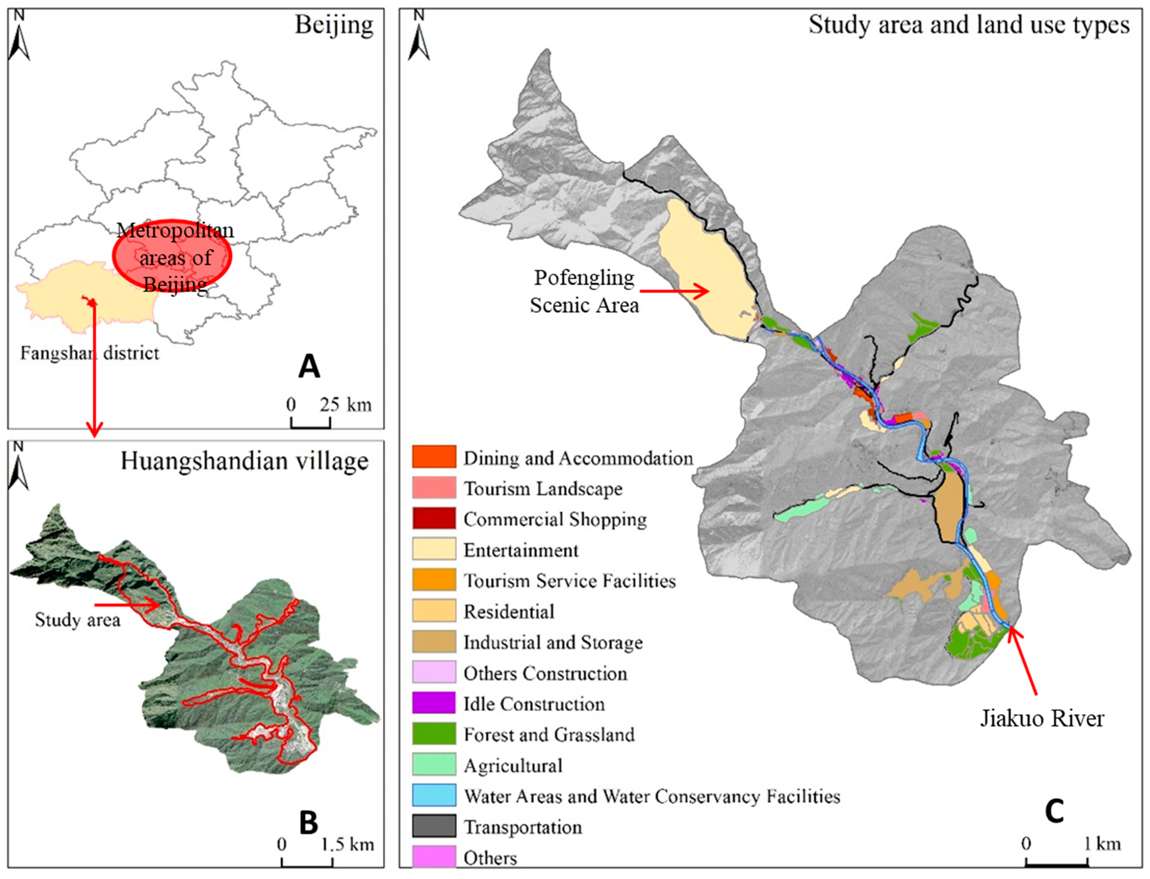
Huangshandian Village is a typical rural tourism destination in metropolitan suburbs of south-western Beijing, within the Taihang Mountains (presented in Figure 2A), and features for karst landforms. There is Jiakuo River running through the village, which covers 20.2 km2 and consists of three natural settlements with 582 households and 1311 residents. Before 2009, it is an impoverished village dependent on agriculture. And then it has pursued eco-tourism development through a collective economic model integrating village leadership, enterprise-style operations, and villager shareholding. This transformation has fostered a tourism-oriented economy centered on high-end homestays and diversified functions, such as cultural experiences, leisure, and education, gathering around the gully areas, shown in Figure 2B. In this study, land use analysis focuses on the main tourism development zones of Huangshandian Village rather than the entire village (Figure 2C), where tourism-related land use change is concentrated, thereby enabling a clearer identification of the stages and trajectories of land use change.

3.2. Land Use Type

In the field of rural tourism, there is no standardized classification system for land use types [36]. Existing classification frameworks are predominantly based on the Current Land Use Classification (GB/T 21010-2017) [37] and are often adapted to specific research contexts through field investigations. To more accurately reflect the land use types in Huangshandian Village and provide a comprehensive depiction of the spatial and temporal evolution of various land use types, this study builds upon previous research [1,38,39] and incorporates fieldwork to develop a refined land use classification system.
Given that grassland occupies a limited area in the study region and its tourism functions largely overlap with those of forest land, this study merges forest land and grassland in the land use classification to facilitate an integrated analysis of the tourism utilization of natural ecological landscapes.
Furthermore, this study introduces a more refined categorization of land use types, with particular emphasis on commercial and service land uses, in order to enable a more precise analysis of land use function evolution. Unlike previous studies [40,41], this approach pays specific attention to tourism-related land use. The land use types in Huangshandian Village are categorized into 14 distinct types (Table 1 and Figure 2C), including categories such as dining and accommodation, entertainment, commercial shopping, tourism landscape, and tourism service facilities. These categories, which are closely linked to the tourism sector, are collectively classified as tourism-related land use.

3.3. Transformation Stage Division

This study primarily adopts a key-event-based periodization method. In 2008, Huangshandian Village initiated tourism development with Pofengling Scenic Area opening up to the world. In 2012, a severe rainstorm caused damage to 85% of local houses and land. Leveraging the opportunities of village reconstruction and land consolidation, the village subsequently entered a new stage of tourism development. Since 2017, Huangshandian has utilized idle rural homesteads and dwellings to develop high-end homestays, while continuously creating new tourist attractions, thereby expanding the scale of its tourism industry.
Accordingly, the development process of study case, presented in Table 2, can be divided into three phases: the initial development stage (2008–2012), the rapid expansion stage (2012–2017), and the optimization and upgrading stage (2017–2021), which together capture the distinct characteristics of the village’s tourism trajectory.

3.4. Data Collection

3.4.1. Survey Data

Based on fieldwork conducted in 2022–2023, this study collected survey data through semi-structured interviews and multiple documentary sources, including village chronicles, planning documents, government announcements, and media reports, providing essential contextual information. The interviews focused on themes such as rural tourism development, tourism project construction, and land use, and involved a diverse range of actors, including village committee members, village representatives, and tourism operators (Table 3).

3.4.2. Spatial Data

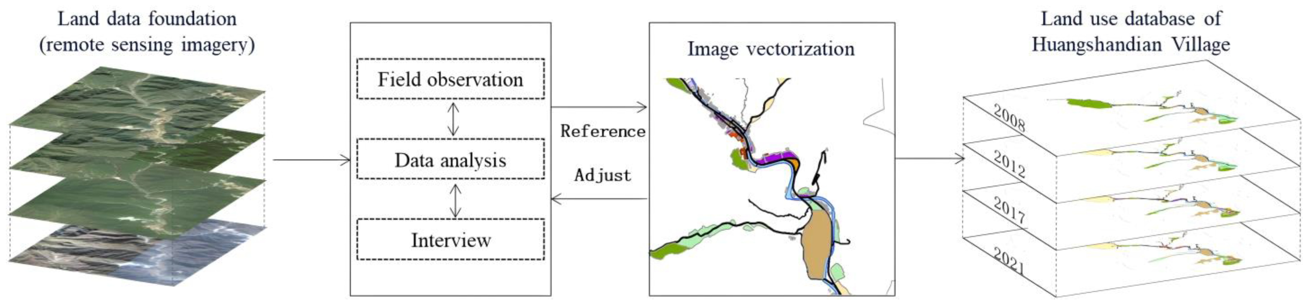
This study utilized remote sensing data for Huangshandian Village from four key years—2008, 2012, 2017, and 2021—sourced from the Bigemap platform. These satellite images were manually interpreted through visual analysis and supplemented with field observations, map materials provided by the village committee, and data obtained from in-depth interviews. The spatial data were then processed using ArcGIS 10.8 software to create vector maps, forming a comprehensive geographic information database on land use across these four years (Figure 3). Subsequently, the study examined the phased characteristics and trajectories of tourism-driven land use changes in Huangshandian Village from 2008 to 2021, using spatial analysis, land use transfer matrix methods, and other techniques.

3.5. Methods

3.5.1. Land Use Structure Diversification Index

The method can be used to evaluate the structural characteristics of various land use types within the study area. The calculation formula is as follows [42]:
G m = 1 i = 1 n x i 2 ( 1 n x i ) 2
Gm represents the Land Use Structure Diversification Index, x i denotes the area of the i-th land use type, and n indicates the total number of different land use types. The value of G m ranges between 0 and 1, with higher values indicating a richer variety of land use types and a greater degree of diversification within the area [43].

3.5.2. Land Use Transition Matrix

This method, as an intuitive and effective analytical tool, can clearly present study area transitions between various land use types over two different time periods in a tabular format.
This method not only quantitatively characterizes the direction of land use changes in a specific region, but also precisely reveals the sources and composition of various land use types at the end of the study period [44]. It has been widely applied in studies on land use change.

3.5.3. Land Function Transformation Importance Index

The Index is used to reflect the significance of land type changes on functional transformations within the study area [45]. The calculation formula is as follows:
I V = N i N + B i B × 100 %
In this equation, I V represents the importance value of a specific land type change, with its magnitude directly indicating the dominant direction of land function transformation. N i denotes the number of patches for the i -th type of land use change, N is the total number of patches for all land use changes, B i represents the area of the i-th type of land use change, and B is the total area of all land use changes. Since both proportions theoretically range from 0 to 1, the resulting IV value ranges from 0% to 200% when expressed in percentage form. A higher IV indicates a stronger contribution of the land use change type to the overall land use evolution, i.e., a higher dominance in terms of both quantity and area.
The land use transition matrix can be generated using ArcGIS and the PivotTable tool in Microsoft Excel 2016, which provides the number of patches and the area of transitions for various land use types that have changed within a specific time period.

4. Land Use Changes Characteristics

4.1. Changes in Land Use Scale

As shown in Table 4, the land use in Huangshandian Village underwent significant changes driven by tourism from 2008 to 2021. In 2008, the village’s economy was largely based on industrial activities and traditional agriculture, with major land types consisting of forest and grassland (51.88%), industrial and storage land (15.99%), and agricultural land (15.55%). From 2008 to 2012, the forest and grassland area decreased, while tourism-related land use expanded, particularly with the development of the Pofengling Scenic Area. This expansion included increases in land for dining and accommodation (0.66 hm2) and tourism service facilities (2.12 hm2).
Between 2012 and 2017, the tourism industry expanded rapidly, with tourism-related land use increasing from 18.24% to 26.36% of the total land, an increase of 43.19 hm2. The conversion of forest and grassland as well as agricultural land to tourism use became more pronounced. Additionally, following the 2012 rainstorm disaster, old residential buildings were demolished, adding 16.90 hm2 of other construction land.
From 2017 to 2021, tourism continued to grow, accompanied by further conversion of idle land, forest and grassland, and agricultural land into tourism-related use. By 2021, tourism land increased by 113.01 hm2, accounting for 47.64% of the total land area. Notable growth was observed in dining and accommodation (6.08 hm2), tourism landscape (5.87 hm2), commercial shopping (0.01 hm2), entertainment (100.41 hm2), and tourism service facilities (0.62 hm2). These changes not only reflect the growth of tourism, but also indicate the gradual optimization of land use patterns in Huangshandian Village.

4.2. Changes in Land Use Structure

The land use structure diversification indexes for Huangshandian in 2008, 2012, 2017, and 2021 were 0.67, 0.80, 0.82, and 0.78, respectively. This indicates an overall increase in land use diversification with the development of rural tourism.
In 2008, the land use structure was relatively homogeneous, with a diversification index of 0.67. However, from 2008 to 2017, the index rose to 0.82, reflecting a period of accelerated diversification driven by the expansion of tourism. During this time, the area dedicated to tourism-related land use increased, contributing to a more complex land use structure. This shift represents the ongoing adjustment and optimization of land use to accommodate industrial transformation and the growing tourism sector.
In 2021, the land use structure diversification index slightly decreased to 0.78 but remained at a relatively high level and was still higher than that in 2008. This change reflects a tendency toward structural concentration, characterized by the increasing conversion of multiple land use types into tourism-related land. As tourism land expanded in both scale and proportion, its relative dominance within the land use structure increased, resulting in a modest decline in the diversification index while maintaining an overall diversified land use pattern.

4.3. Changes in Land Use Functions

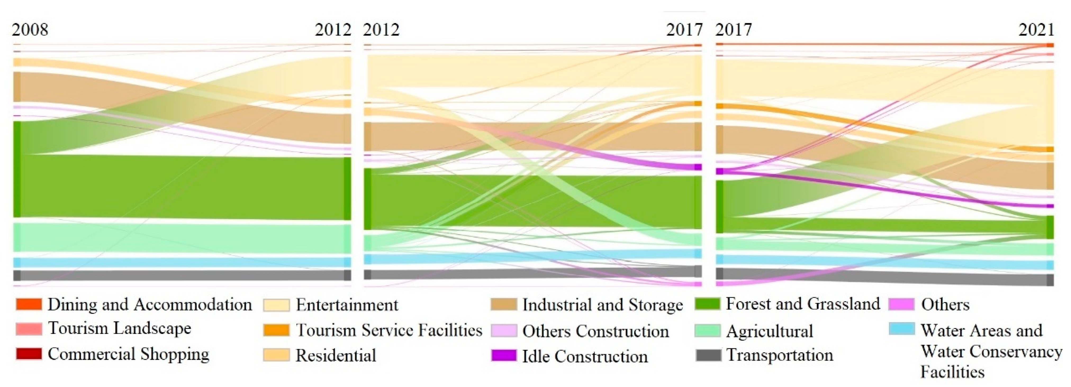
To analyze land use transitions and assess functional changes, this study calculated the importance index (IV) based on land transfer matrix data (shown in Table 5). Only the four land types with the highest IV values are listed. Figure 4 presents a Sankey diagram of land use transitions.
From 2008 to 2012, the dominant land use transformation was towards entertainment land (IV = 152.31%), followed by tourism service facilities and dining and accommodation. As shown in Figure 4, a large area of forest and grassland was converted into recreational land, which highlights its relative dominance in the overall land use structure. Other land type conversions were minimal, indicating a stable structure. Between 2012 and 2017, with the demolition of old residential homes, idle construction land became the primary focus of land use function transformation, with an IV value of 65.24%. Simultaneously, adjustments in land use increased the area of new residential land, with an IV of 18.75%. To meet the rapidly growing market demand, conversions to entertainment (IV = 27.86%) and tourism service facilities (IV =20.33%) were significant. Forest and grassland, along with agricultural land, were mainly converted into tourism-related uses, signaling a shift towards tourism functions.
From 2017 to 2021, entertainment land continued expanding (IV = 76.02%). Accommodation, dining, and service functions were continuously improved as the scale of land use increased. Notably, with the national and local emphasis on ecological environmental protection, forest and grassland became the land type with the largest area of conversion during this period, with an IV of 37.59%. The primary contributors to this transfer included industrial and storage land, agricultural land, entertainment land, and other types of land.
Overall, rural tourism development has diversified land use functions in Huangshandian Village, transitioning from traditional industrial and agricultural uses to tourism-related functions such as dining, accommodation, shopping, and recreation. This transformation has fostered economic growth and set a strong foundation for the village’s sustainable development.

4.4. Changes in Land Use Patterns

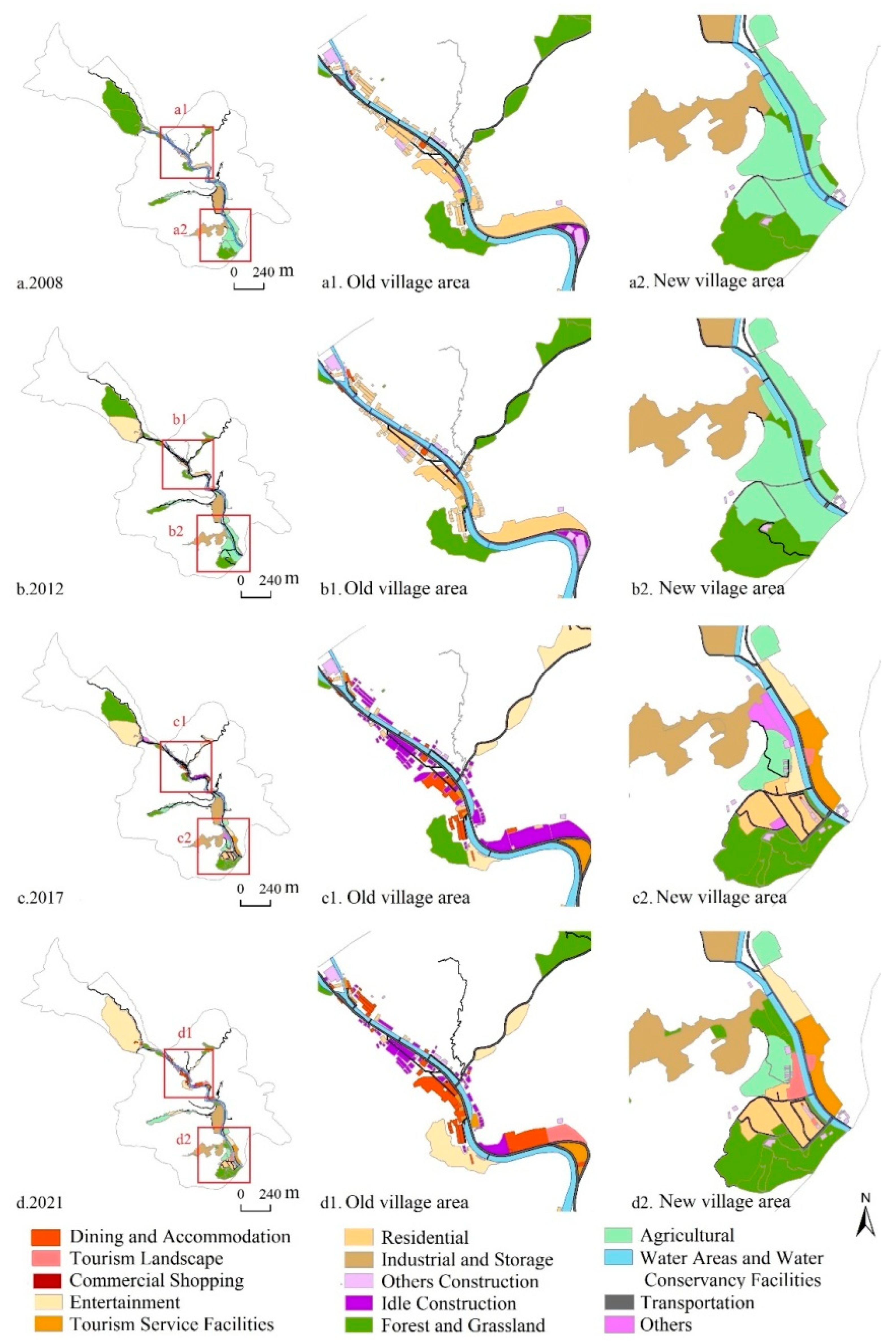
As shown in Figure 5, from 2008 to 2021, the land use pattern underwent significant changes driven by tourism, particularly in the old and new village areas where tourism-related functions became concentrated. In 2008, the village’s land use was primarily focused on industrial and agricultural production, featuring a simple structure with a high concentration of similar land types. This reflected a typical “core residential + peripheral production and ecological” layout.
Between 2008 and 2012, the development of the Pofengling Scenic Area prompted an expansion of tourism-related land in the northwest. However, due to the small scale of the tourism industry at this time, land use changes were modest, concentrated around the scenic area. From 2012 to 2017, tourism land expanded along the roads and into the southern area. Agricultural land was converted into leisure agricultural use. The old village’s residential areas gradually became idle construction land, attracting tourism-related functions such as dining, accommodation, and entertainment. Meanwhile, the southern new village became the primary residential area. During this period, land use exhibited a multi-point diffusion driven by market demand and the diversification of tourism-related industries.
By 2021, land use conversions had stabilized, and the structure was further optimized. Tourism functions began to concentrate, forming a strip-shaped “fishbone” spatial pattern: the old village became the core for “accommodation and reception,” while peripheral areas supported “leisure entertainment,” “comprehensive services,” and “residential living.” This spatial separation of residential and tourism functions facilitated the balanced and coordinated development of the village, optimizing the integration of tourism and local livelihoods.

5. Discussion

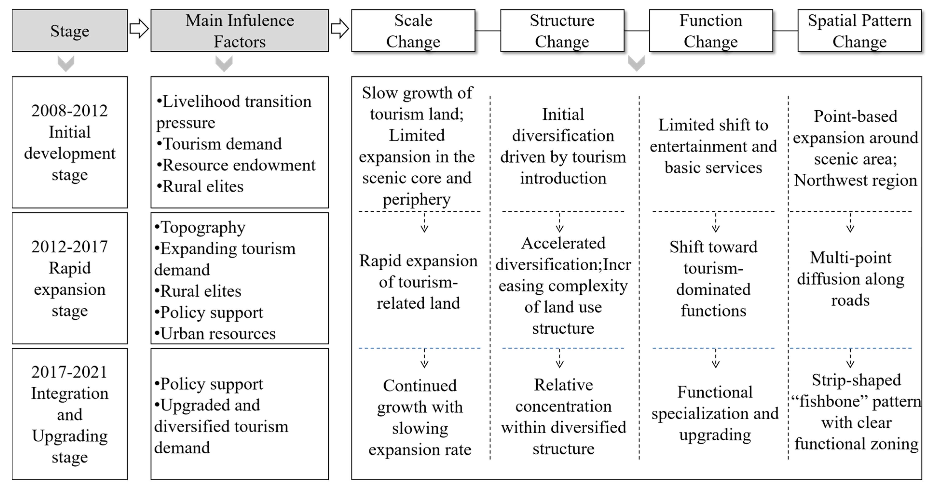
Tourism-driven rural land-use change in metropolitan suburban areas is not the outcome of a single driving factor. Rather, it represents a stage-based evolutionary process jointly shaped by structural environmental conditions, interactions among multiple actors, and modes of resource allocation within a specific urban–rural relational context. Variations in the dominant mechanisms across different development stages directly determine how land-use change is manifested in terms of scale, structure, function, and spatial configuration (Figure 6). Based on the land-use outcomes identified above, this section discusses the underlying mechanisms from a stage-based perspective.

5.1. Initial Development Stage (2008–2012)

During this stage, land use change in Huangshandian Village was primarily driven by pressures for rural economic transformation, growing tourism market demand, tourism resource endowments, and the agency of rural elites.
Prior to 2008, the village’s development primarily depended on an industrial economy. Although industrialization increased collective and household incomes to some extent, it also caused environmental problems such as mountain degradation, vegetation loss, and dust pollution. Faced with simultaneous environmental pressures and economic growth needs, the village sought sustainable alternative development pathways.
At the same time, rising urban demand for rural leisure and tourism provided a critical external opportunity. (“The inspiration for developing Pofengling came from seeing how popular Xiangshan was at the time—more than 100,000 visitors a day. With such rich resources, we couldn’t afford not to make use of them.”—H01). In this context, returning local elites, endowed with innovation, managerial capacity, and organizational skills, played a central role in mobilizing and encouraging villagers and integrating resources for tourism development. Leveraging the village’s rich natural resources—including mountains, forests, and ornamental tree species with fantastic landscape—they promoted the development of the Pofengling Scenic Area.
Land-use change during this stage was characterized by localized, incremental, and low-intensity adjustments. Tourism-related land gradually formed around the scenic area, while agricultural and ecological land remained dominant. Land functions also began transitioning from single-purpose agriculture and ecological conservation toward tourism services, including sightseeing, dining, and accommodation.
In summary, internal economic pressures provided the impetus for change, urban tourism demand created external opportunities, and returning elites drove initial land-function transformation through resource integration and coordination. Coupled with abundant tourism resources, these factors collectively facilitated the early transition of land use from traditional agriculture and ecological purposes to preliminary tourism functions.

5.2. Rapid Expansion Stage (2012–2017)

With the continuous expansion of tourism activities, land-use changes entered a phase of accelerated growth. During this stage, the dominant mechanism shifted from individual-led initiatives to multi-actor coordination, driven by sustained market demand, government policy support, leadership by rural elites, and inflows of urban capital, technology, and managerial talent. Meanwhile, physical environmental factors, including topography and spatial accessibility, exerted a more pronounced influence on the spatial trajectories of land-use change. Located within a narrow valley, Huangshandian Village faced significant constraints on large-scale, centralized construction. As a result, tourism facilities developed in a multi-nodal and strip-like pattern along transportation corridors and valley floors.
Rising tourism demand attracted large numbers of urban visitors, rapidly increasing the need for dining, accommodation, and leisure services, and thereby providing strong impetus for the expansion of tourism-related land. The 2012 heavy rain disaster damaged residences and farmland, but also created opportunities for land consolidation and tourism development. Subsequently, government policies and financial support—including land integration, infrastructure construction, and environmental remediation—provided institutional guarantees and material foundations for tourism projects. (“After the 2012 flood, the government began investing in repairing infrastructure and improving roads, including electricity supply and road foundations. The new village was developed with government subsidies.”—H02).
At the actor level, under the guidance of local elites, the village collective became the central coordinating actor, establishing tourism development and management companies and collaborating with enterprises such as “Hidden Village. (“Let professionals handle professional matters… Only by bringing in professionals first can we keep pace with the times.”—H01). Through shareholding and cooperative models, the collective unified planning, integrated land ownership and rights, and promoted villager participation, creating a governance pattern characterized by collective leadership, enterprise operation, and community engagement. Institutionalized structures, such as cooperative shares and company-led management, enhanced collective control over land use and facilitated industrial development.
Huangshandian Village has attracted a large number of professional talents from Beijing, including planners, architects, and professional managers. (“Let professionals handle professional matters…Only by bringing in professional expertise first can we keep pace with the times.”—H01). The continuous inflow of urban capital, technology, and managerial talent further optimized the tourism industry layout, improved construction efficiency, and accelerated the expansion and functional agglomeration of lands for homestays, dining, and entertainment. Tourism development also generated employment, increased villagers’ income, and enhanced professional skills, consolidating the actor network and stabilizing local governance.
Overall, during this stage, tourism-related land expanded substantially, land use diversified, and spatial patterns exhibited multi-point diffusion, strip-like distribution, and functional mixing. Topography shaped the spatial layout, market demand drove expansion, government policies provided institutional support, urban inputs supplied capital and technical resources, and the village collective’s leadership ensured the sustainability of land-use transformation. The integration of land ownership consolidation, enterprise-led operation, and villager participation effectively addressed implicit land-use changes alongside explicit functional transformations, facilitating large-scale, coordinated tourism development.

5.3. Integration and Upgrading Stage (2017–2021)

During the integration and upgrading stage, the dominant mechanisms of land-use change further shifted toward the synergistic effects of policy guidance and upgraded tourism market demand, with land-use transition evolving from scale-oriented expansion to function optimization and spatial restructuring.
With the deepening implementation of the rural revitalization strategy, the government introduced a series of policies encouraging the activation of idle construction land and homesteads, promoting the development of high-quality homestays, specialty dining, and cultural-creative businesses. These policies provided institutional guarantees and streamlined approvals, facilitating the optimization of land functions and spatial patterns. By ensuring the effective allocation of land resources, they supported rural tourism development and safeguarded the village’s long-term economic sustainability.
Concurrently, tourism market demand became increasingly sophisticated. Visitors shifted from purely sightseeing toward leisure vacations, cultural experiences, and other diversified forms of immersive consumption, driving continuous renewal and enrichment of the village’s tourism product structure. By 2021, the number of tourism enterprises reached 72 (shown in Table 6), a 44.00% increase from 2017. This growth was driven both by large-scale urban market demand and upgraded consumer expectations.
Demand upgrading not only stimulated the quality improvement of homestays and dining facilities, but also promoted the integration of new functions such as cultural exhibitions, leisure and entertainment, and educational tourism. This facilitated the redevelopment and functional repurposing of previously underutilized or idle land. As a result, the scale of tourism land expanded, and the spatial layout shifted from a single scenic-area-centered cluster to a multi-node, multi-functional integrated pattern, with continuously increasing spatial utilization intensity and functional mixing.
Overall, during this period, policy instruments activated existing land resources and provided financial support, offering both land inputs and institutional guarantees for the upgrading and expansion of rural tourism enterprises. Market demand upgrades guided the continuous optimization of land functions and iterative transformation of the industrial structure through heightened consumption levels and diversified preferences. Under the synergy of these factors, tourism land in the village developed toward high-quality, multifunctional, and intensive patterns.

6. Conclusions

This study takes Huangshandian Village in Beijing as a case to systematically examine tourism-driven rural land-use change in a metropolitan suburban context. Based on land-use data from 2008 to 2021, the study identifies a clear staged transformation process—initial development, rapid expansion, and integration and upgrading—characterized by the continuous expansion of tourism-related land, diversification of land-use structure, functional mixing, and evolving spatial patterns.
The results indicate that tourism-driven land-use change in metropolitan suburban villages is not the outcome of a single factor, but rather a staged product jointly shaped by structural environmental conditions, multi-actor interactions, and processes of resource mobilization and allocation. Urban–rural factor flows provide external opportunities and constraints, while local governments, village collectives, rural elites, and market actors collaboratively shape land-use patterns through negotiation, coordination, and institutional arrangements.
By applying the “environment–actor–resource–process” analytical framework, this study reveals how multiple drivers operate across different development stages and jointly influence land-use scale, structure, function, and spatial configuration. The findings not only advance theoretical understanding of land-system transformation at the urban–rural interface, but also provide empirical evidence and policy insights for land-use planning, tourism resource management, and sustainable rural tourism development in metropolitan suburban areas.

7. Contribution and Limitations

7.1. Theoretical Contribution

This study focuses on tourism-oriented villages in metropolitan suburbs, thereby extending the spatial perspective of research on tourism-driven rural land-use change. By situating the analysis within an urban–rural relational context characterized by continuous and asymmetric flows of elements between metropolitan cores and suburban rural areas, the study reveals the staged evolutionary characteristics of rural land-use systems and their underlying formation mechanisms, deepening theoretical understanding of urban–rural element flows and spatial reconfiguration processes.
At the theoretical level, this study develops and empirically applies a multi-layer analytical framework of “environment–actors–resources–process.” The framework systematically links macro-level structural environmental conditions, meso-level interactions among actors, and micro-level processes of resource mobilization and allocation. It elucidates how multiple driving forces jointly operate across different development stages—through actor negotiation, resource reorganization, and institutional arrangements—to shape changes in land-use scale, structure, function, and spatial patterns. By adopting a processual and relational perspective, the framework provides a theoretically robust and transferable tool for explaining the mechanisms underlying tourism-driven rural land-use evolution in metropolitan suburban contexts.

7.2. Practical Implications

First, the findings offer guidance for rural land-use planning in metropolitan suburban areas. This study demonstrates that tourism development can significantly reshape land-use scale, structure, function, and spatial layout. Policy-makers and planners should consider the interaction between urban expansion, rural transformation, and tourism growth when formulating land-use strategies. In particular, activating idle land, integrating multiple functions, and coordinating tourism with agricultural and ecological uses can enhance land-use efficiency and sustainability.
Second, this research highlights the importance of policy instruments and institutional arrangements. Government support—such as incentives for high-quality homestays, cultural-creative businesses, and infrastructure development—plays a critical role in facilitating land-use transformation and tourism industry expansion. Establishing clear institutional mechanisms, promoting stakeholder participation, and integrating local elites into planning processes can enhance governance capacity and ensure the long-term viability of tourism-driven land-use changes.
Third, this study underscores the role of local actors and market demand in driving functional and spatial upgrading. Rural elites, entrepreneurs, and villagers act as key agents in mobilizing resources, coordinating activities, and innovating tourism products. Planners should leverage local knowledge and social capital while responding to evolving market preferences, ensuring that tourism development aligns with both community needs and visitor expectations.

7.3. Limitations

This study is primarily based on a micro-level analysis of a single case village, and the generalizability of its conclusions needs to be further verified in more tourism-oriented villages in metropolitan suburban areas. Future research could adopt a comparative perspective, integrating multi-case studies with big data-based spatial analysis to explore the differences in land use evolution among various types of suburban tourism villages and their coupling mechanisms with policy institutions, social networks, and capital models, thereby enhancing both theoretical explanatory power and practical applicability.

Author Contributions

Writing—original draft, conceptualization, validation, writing—review & editing, X.Z.; Data curation, formal analysis, investigation, methodology, S.Z.; Supervision, J.L.; Funding acquisition, project administration, resources, software, T.L.; Writing—review & editing, Q.G. All authors have read and agreed to the published version of the manuscript.

Funding

This research was funded by the National Natural Science Foundation of China (42271257).

Data Availability Statement

The original contributions presented in the study are included in the article, further inquiries can be directed to the corresponding author.

Acknowledgments

The authors are grateful to the anonymous reviewers and the editors for their valuable comments and constructive suggestions, which have greatly contributed to the improvement of this paper.

Conflicts of Interest

The authors declare no conflicts of interest.

References

  1. Xi, J.; Zhao, M.; Ge, Q.; Kong, Q. Changes in land use of a village driven by over 25 years of tourism: The case of Gougezhuang village, China. Land Use Policy 2014, 40, 119–130. [Google Scholar] [CrossRef]
  2. Long, H.; Liu, Y.; Zou, J. Assessment of rural development types and their rurality in eastern coastal China. Acta Geogr. Sin. 2009, 64, 426–434. [Google Scholar]
  3. Gkartzios, M.; Gallent, N.; Scott, M. A capitals framework for rural areas: ‘Place-planning’ the global countryside. Habitat Int. 2022, 127, 102625. [Google Scholar] [CrossRef]
  4. Li, S.; Yang, R.; Long, H.; Lin, Y.; Ge, Y. Rural spatial restructuring in suburbs under capital intervention: Spatial construction based on nature. Habitat Int. 2024, 150, 103112. [Google Scholar] [CrossRef]
  5. Qu, M.; Zollet, S. Neo-endogenous revitalisation: Enhancing community resilience through art tourism and rural entrepreneurship. J. Rural Stud. 2023, 97, 105–114. [Google Scholar] [CrossRef]
  6. Gao, C.; Cheng, L. Tourism-driven rural spatial restructuring in the metropolitan fringe: An empirical observation. Land Use Policy 2020, 95, 104609. [Google Scholar] [CrossRef]
  7. Chai, Y.; Qiao, W.; Hu, Y.; He, T.; Jia, K.; Feng, T.; Wang, Y. Land-use transition of tourist villages in the metropolitan suburbs and its driving forces: A case study of she village in Nanjing city, China. Land 2021, 10, 168. [Google Scholar] [CrossRef]
  8. Liu, Y.; Liao, H.; Qiu, J.; Liu, Y. Characteristics of spatiotemporal variations and driving factors of land use for rural tourism in areas that eliminated poverty. Land 2023, 12, 910. [Google Scholar] [CrossRef]
  9. Sharpley, R. Rural tourism and the challenge of tourism diversification: The case of Cyprus. Tour. Manag. 2002, 23, 233–244. [Google Scholar] [CrossRef]
  10. Sun, P.; Cao, H. Tourism Development and Rural Land Transfer-Out: Evidence from China Family Panel Studies. Land 2024, 13, 426. [Google Scholar] [CrossRef]
  11. Zhou, G.; Long, H. Explanation of land-use system evolution: Modes, trends, and mechanisms. Land Use Policy 2025, 150, 107470. [Google Scholar] [CrossRef]
  12. Zou, Y.; Du, P.; Liu, Y.; Luo, Z.; Liu, H.; Luo, F.; Yi, C.; Wu, P.; Song, Y. Evolution of rural settlements and its mechanism under the influence of A-class scenic spots in karst region: A case study of Guizhou Province in southwestern China. Habitat Int. 2025, 164, 103504. [Google Scholar] [CrossRef]
  13. Kan, K.; Sun, J. Dispossession and beyond: Politics of rural land conversion in China’s tourism villages. J. Rural Stud. 2024, 112, 103429. [Google Scholar] [CrossRef]
  14. Ayhan, Ç.K.; Taşlı, T.C.; Özkök, F.; Tatlı, H. Land use suitability analysis of rural tourism activities: Yenice, Turkey. Tour. Manag. 2020, 76, 103949. [Google Scholar] [CrossRef]
  15. Cucari, N.; Wankowicz, E.; Esposito De Falco, S. Rural tourism and Albergo Diffuso: A case study for sustainable land-use planning. Land Use Policy 2019, 82, 105–119. [Google Scholar] [CrossRef]
  16. d’Avila, R.; Pesoa, M.; García, G.; Rocamonde, J. Land consumption and urbanization in rural areas. Understanding the dynamics of land take and demographic changes in rural municipalities in Catalonia, Spain. Habitat Int. 2025, 162, 103443. [Google Scholar] [CrossRef]
  17. Hu, K.; Qin, F.; Hu, Y. Micro scale analysis on the evolution of rural tourism land use pattern—A case study of Xizhuang Village in Beijing. Chin. J. Agric. Resour. Reg. Plan. 2020, 41, 238–248. [Google Scholar]
  18. Salem, M.; Ravetz, J.; Sareen, S.; Dong, T.; Haque, M.; Bayoumi, W.; Tsurusaki, N.; Xu, G. Managing the urban-rural transition: A review of approaches and policies for peri-urban land use. J. Urban Manag. 2025, 14, 1115–1129. [Google Scholar] [CrossRef]
  19. Gallent, N.; Purves, A.; Gabrieli, T. Reflections on ‘land value recovery’ for UK rural areas, and its implications for housing affordability, wealth-building, rural land use, and community wellbeing. Habitat Int. 2024, 153, 103204. [Google Scholar] [CrossRef]
  20. Grabska-Szwagrzyk, E.; Hashemvand Khiabani, P.; Pesoa-Marcilla, M.; Chaturvedi, V.; de Vries, W.T. Exploring land use dynamics in rural areas. An analysis of eight cases in the Global North. Land Use Policy 2024, 144, 107246. [Google Scholar] [CrossRef]
  21. Baldwin, C.; Hamerlinck, J.; Mckinlay, A. Institutional support for building resilience within rural communities characterised by multifunctional land use. Land Use Policy 2023, 132, 106808. [Google Scholar] [CrossRef]
  22. Tønnesen, A.; Guillen-Royo, M.; Cottis Hoff, S. The integration of nature conservation in land-use management practices in rural municipalities: A case study of four rural municipalities in Norway. J. Rural Stud. 2023, 101, 103066. [Google Scholar] [CrossRef]
  23. Bullock, R.; Lamoureux, B. Understanding “public” framings of private places and psychological ownership in a rural land use conflict. J. Rural Stud. 2025, 114, 103477. [Google Scholar] [CrossRef]
  24. Samper-Mendívil, M.; Aramendia-Muneta, M.E.; Alarcón-López, R. Assessing sustainability in rural tourism: Insights from accommodation managers and residents in Navarre. J. Rural Stud. 2025, 120, 103866. [Google Scholar] [CrossRef]
  25. Xia, C. Varied rural dreams? External elites’ conception of rurality and their influence on the production of rural space in China’s rural revitalization. J. Rural. Stud. 2025, 119, 103781. [Google Scholar] [CrossRef]
  26. Li, W.; Zhou, Y.; Zhang, Z. Strategies of Landscape Planning in Peri-Urban Rural Tourism: A Comparison between Two Villages in China. Land 2021, 10, 277. [Google Scholar] [CrossRef]
  27. Ristić, D.; Vukoičić, D.; Milinčić, M. Tourism and sustainable development of rural settlements in protected areas—Example NP Кopaonik (Serbia). Land Use Policy 2019, 89, 104231. [Google Scholar] [CrossRef]
  28. Wei, C.; Ge, D.; Long, H.; Liu, S. The tourism-led rural transformation development mode in the metropolitan fringe region: The case of Wuhan City. Econ. Geogr. 2018, 38, 211–217. [Google Scholar] [CrossRef]
  29. Liu, C.; Dou, X.; Li, J.; Cai, L.A. Analyzing government role in rural tourism development: An empirical investigation from China. J. Rural. Stud. 2020, 79, 177–188. [Google Scholar] [CrossRef]
  30. Boley, B.B.; McGehee, N.G. Measuring empowerment: Developing and validating the Resident Empowerment through Tourism Scale (RETS). Tour. Manag. 2014, 45, 85–94. [Google Scholar] [CrossRef]
  31. Gao, J.; Wu, B. Revitalizing traditional villages through rural tourism: A case study of Yuanjia Village, Shaanxi Province, China. Tour. Manag. 2017, 63, 223–233. [Google Scholar] [CrossRef]
  32. Mykola, I.; Vadym, A.; Anatoliy, P.; Yurii, H.; Nataliia, R. Features of the content and implementation of innovation and investment projects for the development of enterprises in the field of rural green tourism. Int. J. Manag. 2020, 11, 304–315. [Google Scholar]
  33. Zhou, L.; Chan, E.; Song, H. Social capital and entrepreneurial mobility in early-stage tourism development: A case from rural China. Tour. Manag. 2017, 63, 338–350. [Google Scholar] [CrossRef]
  34. Komppula, R. The role of individual entrepreneurs in the development of competitiveness for a rural tourism destination—A case study. Tour. Manag. 2014, 40, 361–371. [Google Scholar] [CrossRef]
  35. McGehee, N.G.; Andereck, K.L. Factors predicting rural residents’ support of tourism. J. Travel Res. 2004, 43, 131–140. [Google Scholar] [CrossRef]
  36. Wu, K.; Rui, Y.; Chen, J.; Zhang, L.; Yang, X.; Zhang, B. Micro-scale study on rural transformation and development driven by tourism: Taking Shangwang Village in Xi’an City as an example. Prog. Geogr. 2020, 39, 1047–1059. [Google Scholar] [CrossRef]
  37. GB/T 21010-2017; Current Land Use Classification. Standards Press of China: Beijing, China, 2017.
  38. Xu, Q.; Li, Y.; Huang, J. Study on land pattern and function evolution of rural settlements dependent on scenic spot: A case study of Shitouzhai Village in Huangguoshu Town. Resour. Environ. Yangtze Basin 2020, 29, 1545–1554. [Google Scholar]
  39. Zhang, H.; Li, Y. Change of land-use functions in suburbs:A case study of Haohuahong Village in a rural tourist resort of Huishui County, Guizhou Province. Prog. Geogr. 2020, 39, 1999–2012. [Google Scholar]
  40. Wan, P.; Xu, G.; Wan, C. Evolution and simulation of land use functional structure in rural tourism destinations: A case study of Sanping Village in Jiangxi Province. Prog. Geogr. 2023, 42, 1769–1782. [Google Scholar]
  41. Yang, R. The actor-network perspective on the reconstruction process and internal mechanism of typical Taobao villages in the Pearl River Delta region. Acta Geogr. Sin. 2021, 76, 3076–3089. [Google Scholar]
  42. Wei, H. Modern Regional Economics; Economy & Management Publishing House: Beijing, China, 2006. [Google Scholar]
  43. Shi, Y.; Wu, J. Measuring methods and evolution features of urban-rural economic diversification in Shanghai. Econ. Geogr. 2015, 35, 7–13. [Google Scholar] [CrossRef]
  44. Zhu, H.; Li, X. Discussion on the index method of regional land use change. Acta Geogr. Sin. 2003, 58, 643–650. [Google Scholar]
  45. Gao, P.; Xi, J.; Liu, S. Study on the spatial process and dynamic mechanism of tourism urbanization: A case study of the Huangshui Town in Chongqing city, China. Hum. Geogr. 2020, 35, 104–113. [Google Scholar]
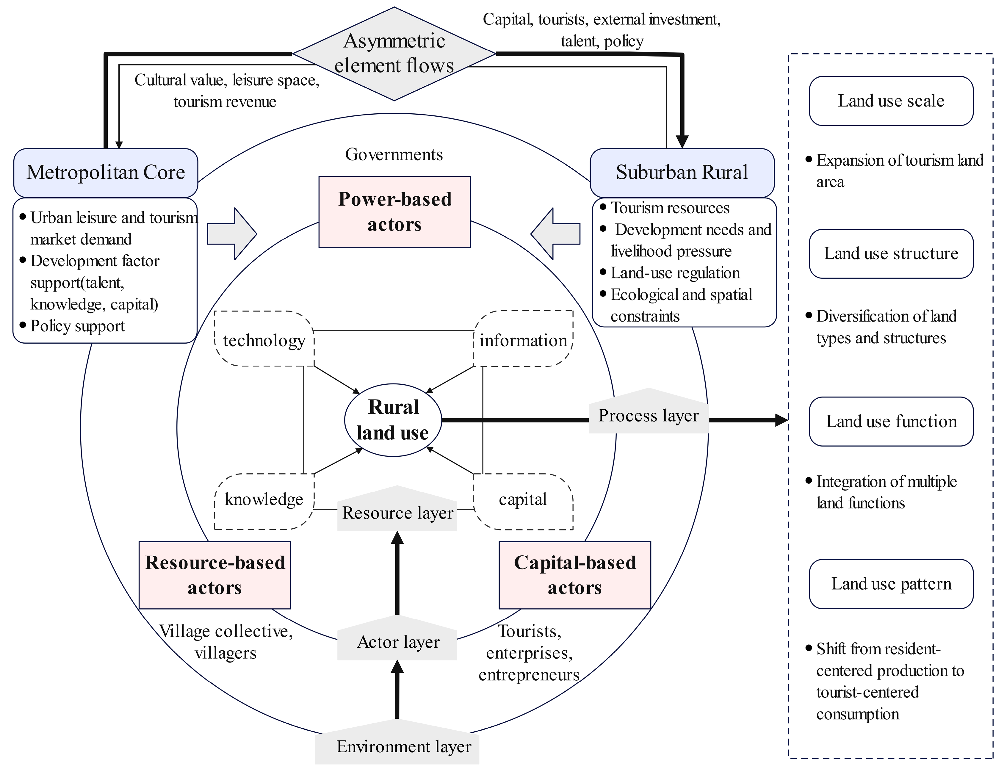
Figure 1. Theoretical framework of the mechanisms.
Land 15 00310 g001
Figure 2. Location and overview of the study area: (A) Regional context of Huangshandian Village in Beijing, China; (B) Huangshandian Village and the study area; (C) Land use patterns and key elements.
Land 15 00310 g002
Figure 3. Data processing flow of land use in Huangshandian Village.
Land 15 00310 g003
Figure 4. Land use function transformation in Huangshandian Village.
Land 15 00310 g004
Figure 5. Spatiotemporal Changes in Land Use in Huangshandian Village (2008–2021): (ad) overall village patterns in 2008, 2012, 2017, and 2021, respectively; (a1d1) land use patterns in the new village area for the corresponding years; (a2d2) land use patterns in the old village area for the corresponding years.
Land 15 00310 g005
Figure 6. Process and main influence factors of land use change.
Land 15 00310 g006
Table 1. Classification of land use types in Huangshandian Village.
NumberLand TypeDescriptionTypical Land Use Type
1Dining and Accommodation Land used to provide dining and lodging facilities for tourists.Snack bars, hotels, guesthouses, inns, farm stays.
2EntertainmentLand used to provide sightseeing, leisure, and entertainment services for tourists.Theme parks, handicraft workshops, botanical gardens, museums.
3Commercial ShoppingLand used for selling souvenirs, local specialties, and cultural and creative products.Supermarkets, souvenir shops, local specialty stores, cultural and creative product shops.
4Tourism LandscapeLand developed to meet tourists’ needs for sightseeing and esthetic enjoyment.Sculptures, scenic forests, grasslands, flower fields.
5Tourism Service FacilitiesLand used to accommodate service facilities catering to tourists’ needs.Parking lots, tourist service centers, ticket offices, tourist toilets, cable car stations.
6ResidentialLand used for residential buildings and their auxiliary facilities.Single-story houses, multi-story buildings, villas.
7Industrial and StorageLand used for industrial production and the storage of goods and materials.Factories, mines, warehouses.
8Idle ConstructionLand that remains undeveloped or unused.Idle houses, homestead land.
9Other ConstructionLand used for public administration and service facilities, special-use areas, and non-tourism commercial services.Schools, hospitals, post offices, village committees, police stations, stadiums, military facilities.
10Forest and GrasslandLand primarily covered by trees, bamboo, or herbaceous plants.Arboreal forests, bamboo groves, shrublands, grasslands.
11AgriculturalLand directly or indirectly used for agricultural production.Farmland, orchards, tea plantations, and agricultural facilities.
12Water Areas and Water Conservancy FacilitiesLand used for water bodies, mudflats, ditches, swamps, and hydraulic structures.Rivers, lakes, reservoirs, mudflats, ditches, ponds.
13TransportationLand used for transportation routes and related facilities.Roads, roadside tree belts, embankments, bus stops, bridges.
14OthersLand types not included in the above categories, such as wasteland and bare land.Wastelands, bare land, rocky areas, abandoned land, saline-alkali land.
Table 2. Rural tourism development process of Huangshandian Village.
PhasesFeaturesDevelopment Process
The initial development stageThe transformation of resource-based industries into eco-tourismBetween 2001 and 2008, the local region vigorously developed its industrial and mining sectors. In 2009, the construction of Pofengling Scenic Area was officially launched to improve the rural ecological environment and landscape appearance, with a strong focus on developing rural tourism.
The rapid expansion stageResource integration and industrial-scale developmentBased on the positive effects of rural tourism in increasing income and improving employment, further development measures were implemented, to expand the scale of rural tourism industry and enhance regional reputation and market competitiveness.
The optimization and upgrading stageProduct innovation and cultural empowermentWith the implementation of the “Rural Revitalization Strategy”, local development emphasized the integration of rural tourism and cultural tourism, as well as the revitalization of idle farmhouses to foster new rural industries.
Table 3. Information of key interviewees.
N.GenderIdentity InformationNotes
H01MaleVillage Party Secretary & Village Committee DirectorReturnee entrepreneur, leader of rural development
H02MaleVillage cadreLocal villager
H03MaleVillage cadreLocal villager
H04MaleVillage cadreLocal villager
H05FemaleGeneral manager of Huangshandian Village Tourism CompanyUrban elite working in rural area, extensive experience in rural tourism development
H06FemaleMarketing manager of Huangshandian Village Tourism CompanyUrban elite working in rural area, mainly responsible for brand marketing, etc.
H07MaleOperator of supermarket and Leyijiayuan B&BLocal villager
H08FemaleOperator of Yishanbangshui FarmhouseRenovated accommodation facilities in 2016
H09FemaleBaker at “Wheat’s Glow”Returnee employed
H10MaleHousekeeper of Shanxingji B&BUrban employee working in rural area
H11MaleOperator of Shanxingji B&BUrban investor and entrepreneur; founded Shanxingji B&B
H12MaleEcological Conservation Staff of Huangshandian VillageEmployee from neighboring village
Table 4. Area and percentage of different types of land in Huangshandian Village.
Land Type2008201220172021
hm2%hm2%hm2%hm2%
Dining and Accommodation0.260.050.920.174.950.9311.032.08
Entertainment0.000.0093.8917.66119.1222.41219.5341.30
Commercial Shopping0.070.010.070.010.230.040.240.05
Tourism Landscape0.000.000.000.000.820.166.701.26
Tourism Service Facilities0.000.002.120.4015.072.8415.702.95
Residential22.444.2222.324.2018.713.5218.163.42
Industrial and Storage84.9915.9984.9915.9982.5315.5379.6414.98
Other Construction6.841.296.841.296.111.155.921.11
Idle Construction0.810.150.810.1517.713.339.471.78
Forest and Grassland275.8251.88180.1933.90155.2829.2167.9512.78
Agricultural82.6815.5582.6815.5537.317.0235.666.71
Water Areas and Water Conservancy Facilities27.385.1527.325.1426.965.0726.965.07
Transportation28.915.4429.285.5133.986.3934.646.52
Others1.400.260.170.1512.812.410.000.00
Table 5. IV of land function transformation in Huangshandian Village.
2008–20122012–20172017–2021
Land TypeIV (%)Land TypeIV (%)Land TypeIV (%)
Entertainment152.31Idle Construction65.24Entertainment76.02
Tourism Service Facilities29.96Entertainment27.86Dining and Accommodation44.01
Dining and Accommodation11.78Tourism Service Facilities20.33Forest and Grassland37.59
Transportation5.94Residential18.75Tourism Service Facilities12.04
Table 6. Types and quantities of tourism businesses in different years.
Type Year201220172021
QuantityProportion (%)QuantityProportion (%)QuantityProportion (%)
Dining Establishments444.44510.00912.50
Accommodation00.003876.005475.00
Integrated Food and Accommodation222.2224.0034.17
Shopping store333.33510.0068.33
Total9100.0050100.0072100.00
Disclaimer/Publisher’s Note: The statements, opinions and data contained in all publications are solely those of the individual author(s) and contributor(s) and not of MDPI and/or the editor(s). MDPI and/or the editor(s) disclaim responsibility for any injury to people or property resulting from any ideas, methods, instructions or products referred to in the content.