Establishing Linear Cultural Heritage Corridors by Integrating Cultural and Ecological Values: A Case Study of the Jinzhong Section of the Great Tea Road


Abstract
1. Introduction
- Fragmentation between cultural and ecological value assessment systems. Current heritage assessment largely takes authenticity and integrity as core indicators [21], whereas ecological assessment emphasises habitat quality [22], structural connectivity [23], and ecological risk [24]. The two systems lack a unified, comparable, and overlayable pathway in terms of indicator sets, weighting schemes, and spatial representation, resulting in the separation of cultural heritage conservation from ecological–environmental management and constraining fine-grained characterisation of LCH’s complex spatial attributes [25].
- Homogenised management of corridor types. In management practice, existing studies on linear heritage and regional corridors commonly adopt a typological logic of “zoning–grading–differentiated control”. On the one hand, research on Linear Cultural Heritage stresses route-based organisation to link nodes, builds interpretive systems, and—under multi-actor participation [26] and cross-jurisdictional coordination frameworks—develops governance arrangements for segments with different functions. On the other hand, ecological and landscape studies often identify ecological corridors [27] and regulatory zones [28] guided by ecological security patterns [6], ecological risk [29], and suitability for use [8], and apply them to inform the adaptive use of Linear Cultural Heritage [6] and delineation of conservation boundaries [9]. In addition, studies defining cultural–ecological corridors [10,30] have proposed corridor construction and spatial delineation models for regional systems [31], providing methodological references for corridor zoning and grading [32]. Overall, existing “typological” outputs mostly serve a single objective (cultural display or ecological security) or evaluate culture and ecology in parallel; they still lack a comparable and overlayable “dual-value corridor” within a shared spatial network framework. Consequently, they cannot directly support fine-grained trade-offs among conservation, utilisation, and ecological carrying capacity in linear heritage governance.
- Dynamic imbalance between development utilisation and ecological carrying capacity. From the perspective of sustainable landscape management [33], many LCH nodes face pressures from high-intensity tourism development [34] and capital involvement to stimulate along-corridor economic growth. This development model generates internal conflicts in governance: cultural tourism development seeks improved spatial accessibility [35,36] and facility convenience [37], whereas ecological conservation goals [35] require limiting the intensity of human disturbance. Hence, there is an urgent need for operational zoning-and-grading and differentiated control tools that match resource sensitivity and carrying capacity across different segments and that can be reasonably transferred to shared governance contexts of trans-regional linear heritage such as canals, ancient roads, and trade corridors.
- How can an evaluation system integrating cultural and ecological multidimensional values be constructed to quantitatively identify Linear Cultural Heritage corridors, thereby bridging the current disconnect between heritage conservation and ecological management?
- How can the “dual-dimension Multiple Centrality” analytical framework be applied to deconstruct and grade the corridor network of the Great Tea Road (Jinzhong section)?
- How can the outcomes of corridor classification and heritage site spatial analysis ultimately provide scientific and refined decision-making support for World Heritage nomination assessment, cross-regional spatial governance, and sustainable development of local communities in the Great Tea Road’s Jinzhong section?
2. Research Framework
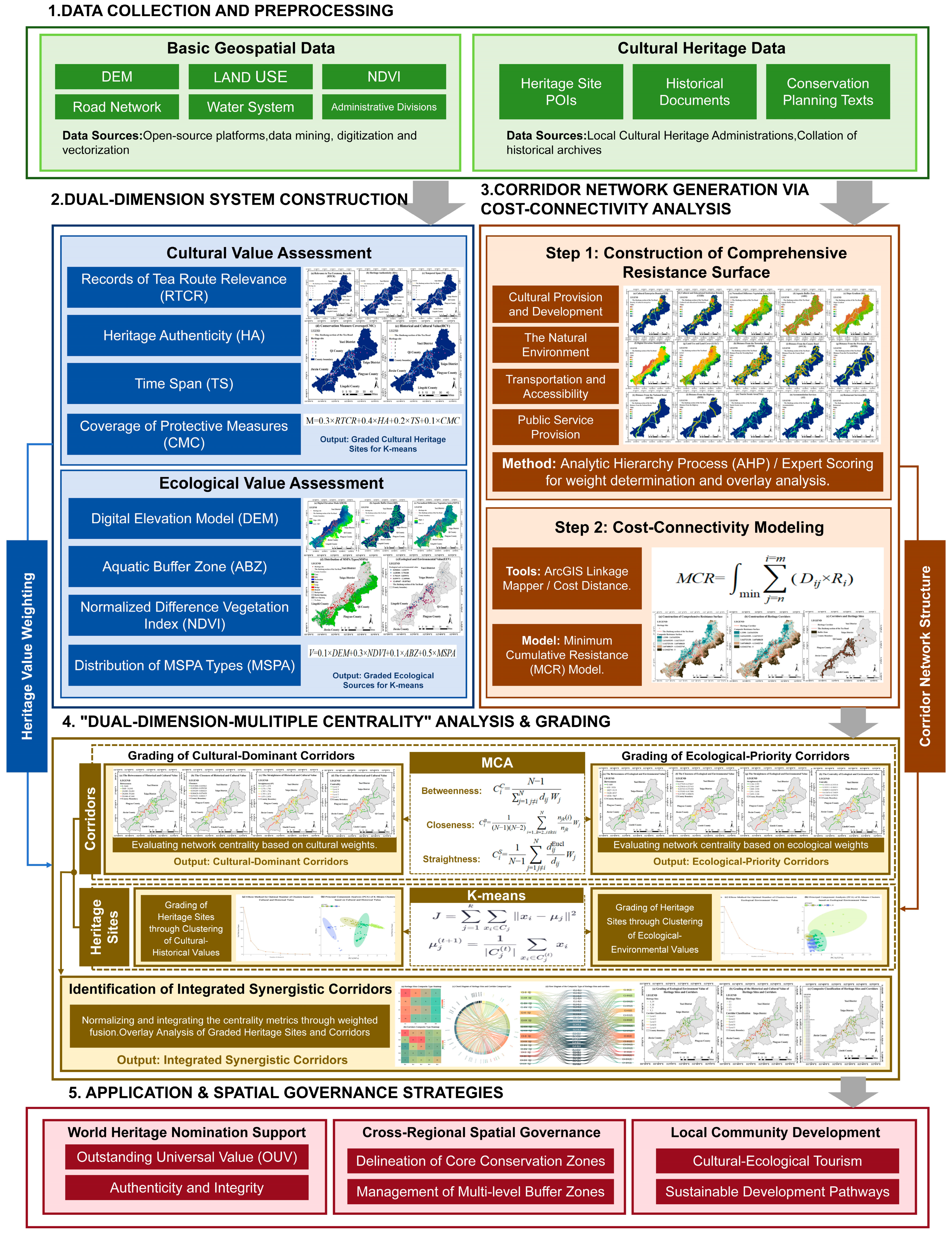
- Dual-Weight System Construction. Based on multi-source geospatial datasets and cultural heritage data, two indicator systems are established for cultural and ecological values, respectively.
- 2.
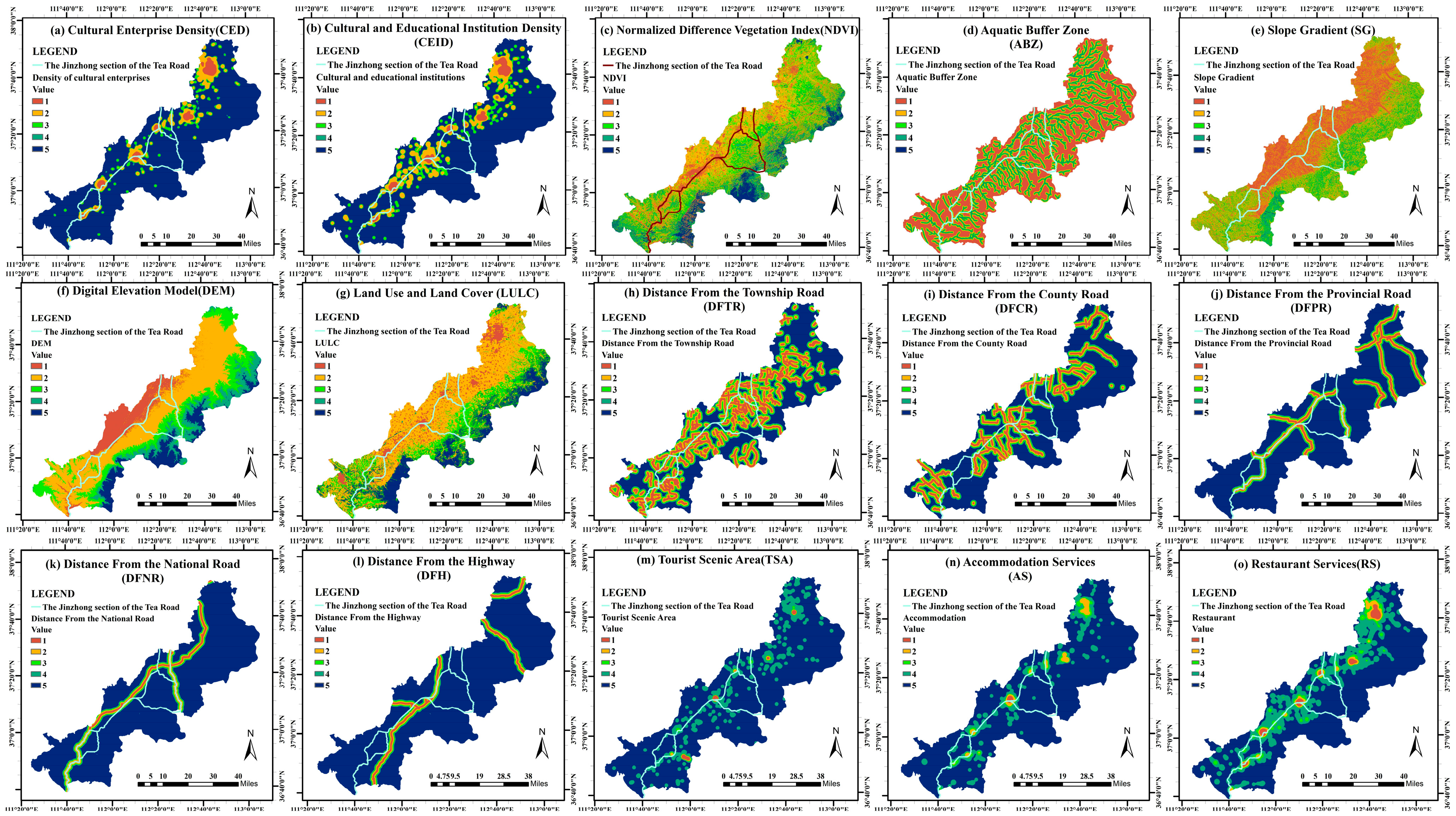
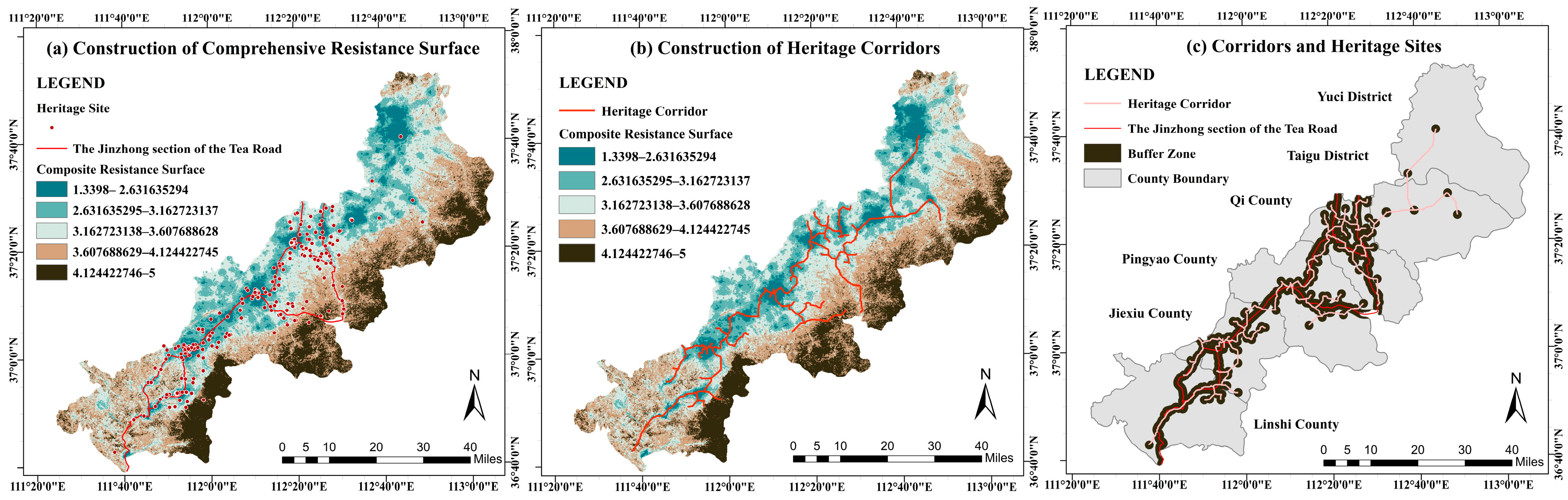
- Corridor Network Generation (Cost-Connectivity-Based Physical Network). Using the ArcGIS platform, factors including elevation, slope, land use, distance to water systems, and transportation networks are overlaid. Weights are determined via the Analytic Hierarchy Process (AHP) to construct an integrated resistance surface. The Minimum Cumulative Resistance (MCR) model is then applied to simulate optimal low-cost paths between heritage sites, generating a baseline candidate corridor network and establishing the physical spatial connectivity of corridors.
- 3.
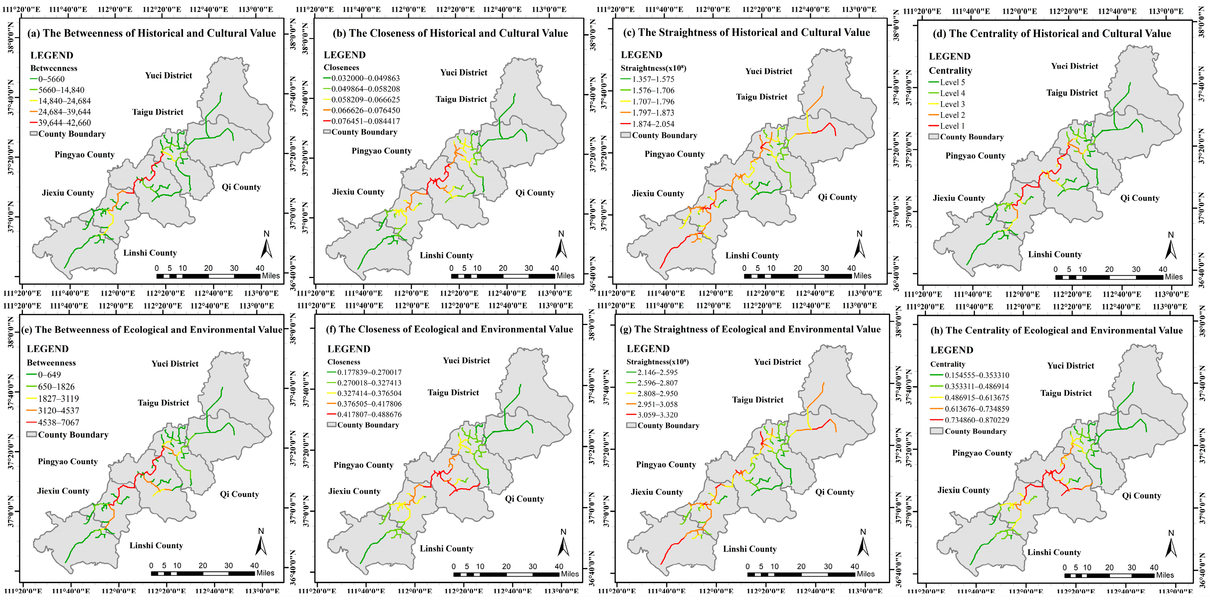
- “Dual-Weight Multi-Centrality” Analysis. This is the core analytical module, aiming to deconstruct structure at both point and line levels:
- 4.
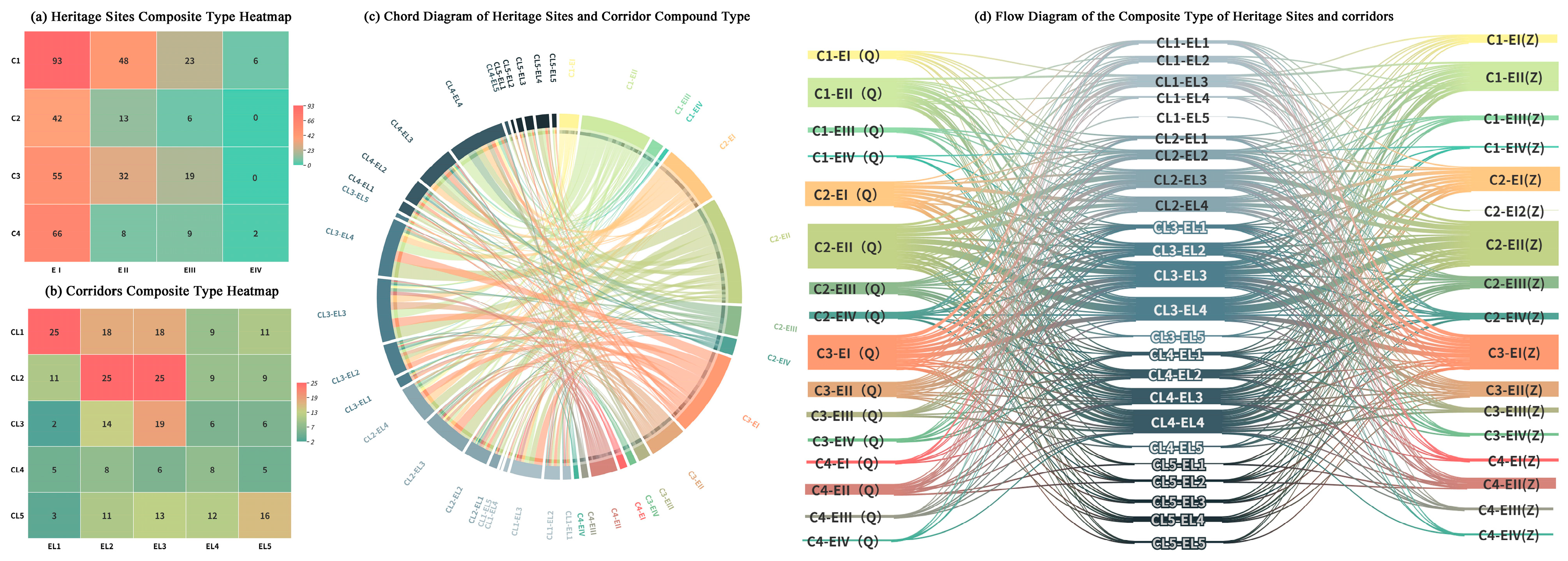
- Application and Governance (Multi-Dimensional Overlay and Collaborative Strategies). Finally, graded heritage sites and corridor networks are spatially overlaid and coupled to identify Integrated Synergistic Corridors featuring both strong cultural linkage and high ecological value. Based on this graded inventory, differentiated spatial governance strategies are proposed from three dimensions: World Heritage nomination justification, cross-regional spatial regulation, and community sustainable development.
2.1. Study Area
2.2. Indicator Selection and Data Sources
2.3. Research Methods
2.3.1. Identification of Ecological Sources Based on MSPA
2.3.2. Minimum Cumulative Resistance (MCR) Model
2.3.3. Multi-Centre Assessment (MCA) Model
2.3.4. K-Means Clustering
3. Results
3.1. Heritage Site Value Weighting
3.1.1. Weighting for Historical and Cultural Value
3.1.2. Ecological and Environmental Value Weighting
3.2. Heritage Corridor Construction Based on the MCR Model
3.2.1. Construction of the Resistance Surface
3.2.2. Corridor Construction
3.3. Heritage Sites and Corridor Grading
3.3.1. K-Means-Based Heritage Site Classification
3.3.2. Heritage Corridor Grading Based on the MCA Model
3.4. Construction of Composite Heritage Sites and Corridors
4. Discussion
4.1. Effectiveness and Advantages of the “Dual-Dimension Multi-Centrality” Framework
4.2. Multi-Scale Governance for Sustainable Landscape Management
4.3. Practical Implications for Heritage Nomination, Governance and Community Development
4.4. Research Limitations and Future Prospects
5. Conclusions
Supplementary Materials
Author Contributions
Funding
Data Availability Statement
Acknowledgments
Conflicts of Interest
References
- Boda, G. The Convention Concerning the Protection of the World Cultural and Natural Heritage (Paris, 1972) and Romania. Plur. Hist. Cult. Soc. 1972, 6, 17–31. [Google Scholar]
- Bhati, H.V.; Epstein, Y. Protection of Biocultural Heritage in the Anthropocene: Towards Reconciling Natural, Cultural, Tangible and Intangible Heritage. J. Environ. Law 2023, 35, 353–375. [Google Scholar] [CrossRef] [Scilit]
- Huo, S. Protección y Gestión de Rutas Patrimoniales. Propuestas Para La “Ruta de La Seda: Red Viaria Del Corredor Chang’an-Tianshan”. Ph.D. Thesis, Universidad de Valladolid, Valladolid, Spain, 2021. [Google Scholar]
- Brumann, C. Shifting Tides of World-Making in the UNESCO World Heritage Convention: Cosmopolitanisms Colliding. Ethn. Racial Stud. 2014, 37, 2176–2192. [Google Scholar] [CrossRef] [Scilit]
- Zhang, S.; Liu, J.; Pei, T.; Chan, C.-S.; Wang, M.; Meng, B. Tourism Value Assessment of Linear Cultural Heritage: The Case of the Beijing–Hangzhou Grand Canal in China. Curr. Issues Tour. 2023, 26, 47–69. [Google Scholar] [CrossRef] [Scilit]
- Li, H.; Zhang, T.; Cao, X.; Yao, L. Active Utilization of Linear Cultural Heritage Based on Regional Ecological Security Pattern along the Straight Road (Zhidao) of the Qin Dynasty in Shaanxi Province, China. Land 2023, 12, 1361. [Google Scholar] [CrossRef] [Scilit]
- Zhou, W.; Cenci, J.; Zhang, J. Systematic Bibliometric Analysis of the Cultural Landscape. J. Asian Archit. Build. Eng. 2024, 23, 1142–1164. [Google Scholar] [CrossRef] [Scilit]
- He, D.; Hu, J.; Zhang, J. Assessment of Sustainable Development Suitability in Linear Cultural Heritage—A Case of Beijing Great Wall Cultural Belt. Land 2023, 12, 1761. [Google Scholar] [CrossRef] [Scilit]
- Li, L.; Feng, R.; Xi, J. Ecological Risk Assessment and Protection Zone Identification for Linear Cultural Heritage: A Case Study of the Ming Great Wall. Int. J. Environ. Res. Public Health 2021, 18, 11605. [Google Scholar] [CrossRef] [Scilit]
- Sun, Y.; Wang, Y.; Liu, L.; Wei, Z.; Li, J.; Cheng, X. Large-Scale Cultural Heritage Conservation and Utilization Based on Cultural Ecology Corridors: A Case Study of the Dongjiang-Hanjiang River Basin in Guangdong, China. Herit. Sci. 2024, 12, 44. [Google Scholar] [CrossRef] [Scilit]
- Steward, J.H. Theory of Culture Change; University of Illinois Press: Urbana, IL, USA, 1955. [Google Scholar]
- Severo, M. European Cultural Routes: Building a Multi-actor Approach. Mus. Int. 2017, 69, 136–145. [Google Scholar] [CrossRef] [Scilit]
- Yang, Y.; Feng, Z.; Wu, K.; Lin, Q. How to Construct a Coordinated Ecological Network at Different Levels: A Case from Ningbo City, China. Ecol. Inf. 2022, 70, 101742. [Google Scholar] [CrossRef] [Scilit]
- Tao, L.; Wang, H.; Li, J.; Zhang, L. Construction of CCSPM Model for Spatial Definition of Cultural Corridor: A Case Study of Cross-Border Cultural Corridor in Southwest Yunnan. Sci. Geogr. Sin. 2022, 42, 602–610. [Google Scholar]
- Yin, L.C.; Liu, P.L.; Li, B.H.; Qi, J.; Hu, Z.; Deng, Y.Y. Map of Traditional Settlement Landscape Morphology Gene: A Case Study of the Xiangjiang River Basin. Sci. Geogr. Sin. 2023, 43, 1053–1065. [Google Scholar]
- Manning, R.E.; Anderson, L.E.; Pettengill, P. Managing Outdoor Recreation: Case Studies in the National Parks, 2nd ed.; CABI: Wallingford, UK, 2017. [Google Scholar]
- Jongman, R.H.; Külvik, M.; Kristiansen, I. European Ecological Networks and Greenways. Landsc. Urban Plan. 2004, 68, 305–319. [Google Scholar] [CrossRef] [Scilit]
- Foster, G.; Saleh, R. The Adaptive Reuse of Cultural Heritage in European Circular City Plans: A Systematic Review. Sustainability 2021, 13, 2889. [Google Scholar] [CrossRef] [Scilit]
- Booher, D.E.; Innes, J.E. Governance for Resilience: CALFED as a Complex Adaptive Network for Resource Management. Ecol. Soc. 2010, 15, art35. [Google Scholar] [CrossRef] [Scilit]
- Zhao, S.; Yang, D.; Gao, C. Identifying Landscape Character for Large Linear Heritage: A Case Study of the Ming Great Wall in Ji-Town, China. Sustainability 2023, 15, 2615. [Google Scholar] [CrossRef] [Scilit]
- Wang, Y.; Huang, S.; Kim, A.K. Toward a Framework Integrating Authenticity and Integrity in Heritage Tourism. J. Sustainable Tourism 2015, 23, 1468–1481. [Google Scholar] [CrossRef] [Scilit]
- Yang, J.; Xie, B.; Zhang, D.; Mak-Mensah, E.; Pei, T. Habitat Quality Assessment and Multi-Scenario Prediction of the Gansu-Qinghai Section of the Yellow River Basin Based on the FLUS-InVEST Model. Front. Ecol. Evol. 2023, 11, 1228558. [Google Scholar] [CrossRef] [Scilit]
- Saura, S.; Pascual-Hortal, L. A New Habitat Availability Index to Integrate Connectivity in Landscape Conservation Planning: Comparison with Existing Indices and Application to a Case Study. Landsc. Urban Plan. 2007, 83, 91–103. [Google Scholar] [CrossRef] [Scilit]
- Hunsaker, C.T.; Graham, R.L.; Suter, G.W.; O’Neill, R.V.; Barnthouse, L.W.; Gardner, R.H. Assessing Ecological Risk on a Regional Scale. Environ. Manag. 1990, 14, 325–332. [Google Scholar] [CrossRef] [Scilit]
- Donati, G.F.A.; Bolliger, J.; Psomas, A.; Maurer, M.; Bach, P.M. Reconciling Cities with Nature: Identifying Local Blue-Green Infrastructure Interventions for Regional Biodiversity Enhancement. J. Environ. Manag. 2022, 316, 115254. [Google Scholar] [CrossRef] [Scilit] [PubMed]
- Aas, C.; Ladkin, A.; Fletcher, J. Stakeholder Collaboration and Heritage Management. Ann. Touris. Res. 2005, 32, 28–48. [Google Scholar] [CrossRef] [Scilit]
- Adriaensen, F.; Chardon, J.P.; De Blust, G.; Swinnen, E.; Villalba, S.; Gulinck, H.; Matthysen, E. The Application of ‘Least-Cost’ Modelling as a Functional Landscape Model. Landsc. Urban Plan. 2003, 64, 233–247. [Google Scholar] [CrossRef] [Scilit]
- Geneletti, D.; van Duren, I. Protected Area Zoning for Conservation and Use: A Combination of Spatial Multicriteria and Multiobjective Evaluation. Landsc. Urban Plan. 2008, 85, 97–110. [Google Scholar] [CrossRef] [Scilit]
- Shi, H.; ping Yang, Z.; Han, F.; ge Shi, T.; Li, D. Assessing Landscape Ecological Risk for a World Natural Heritage Site: A Case Study of Bayanbulak in China. Pol. J. Environ. Stud. 2015, 24, 269–283. [Google Scholar] [CrossRef] [Scilit]
- Xu, H.; Plieninger, T.; Primdahl, J. A Systematic Comparison of Cultural and Ecological Landscape Corridors in Europe. Land 2019, 8, 41. [Google Scholar] [CrossRef] [Scilit]
- Ge, Y.; Liu, Y.; Ma, Y.; Wang, Y.; Guo, Y.; He, J.; Mao, Y. Spatial Identification and Corridor Network Analysis of Cultural Heritage Based on Multi-Model Fusion: A Case Study of Western Henan. Ecol. Indic. 2025, 178, 113859. [Google Scholar] [CrossRef] [Scilit]
- Xu, H.; Zhao, G.; Fagerholm, N.; Primdahl, J.; Plieninger, T. Participatory Mapping of Cultural Ecosystem Services for Landscape Corridor Planning: A Case Study of the Silk Roads Corridor in Zhangye, China. J. Environ. Manag. 2020, 264, 110458. [Google Scholar] [CrossRef] [Scilit]
- Wu, J. Landscape Sustainability Science: Ecosystem Services and Human Well-Being in Changing Landscapes. Landsc. Ecol. 2013, 28, 999–1023. [Google Scholar] [CrossRef] [Scilit]
- Milano, C.; Cheer, J.M.; Novelli, M. Overtourism: Excesses, Discontents and Measures in Travel and Tourism; CABI: Wallingford, UK, 2019. [Google Scholar]
- Kosmas, P.; Galanakis, G.; Constantinou, V.; Drossis, G.; Christofi, M.; Klironomos, I.; Zaphiris, P.; Antona, M.; Stephanidis, C. Enhancing Accessibility in Cultural Heritage Environments: Considerations for Social Computing. Univers. Access Inf. Soc. 2020, 19, 471–482. [Google Scholar] [CrossRef] [Scilit]
- Meng, L.; Du, Z.; Jia, Z.; Cao, L. Spatial Mechanisms and Coupling Coordination of Cultural Heritage and Tourism along the Jinzhong Segment of the Great Tea Road. Heritage 2026, 9, 7. [Google Scholar] [CrossRef] [Scilit]
- Huang, X.; Li, C.; Zhao, J.; Chen, S.; Gao, M.; Liu, H. Investigating Spatial Heterogeneity Patterns and Coupling Coordination Effects of the Cultural Ecosystem Service Supply and Demand: A Case Study of Taiyuan City, China. Land 2025, 14, 1212. [Google Scholar] [CrossRef] [Scilit]
- Tudor, C. An Approach to Landscape Character Assessment. Nat. Engl. 2014, 65, 101716. [Google Scholar]
- Gumiero, B.; Mant, J.; Hein, T.; Elso, J.; Boz, B. Linking the Restoration of Rivers and Riparian Zones/Wetlands in Europe: Sharing Knowledge through Case Studies. Ecol. Eng. 2013, 56, 36–50. [Google Scholar] [CrossRef] [Scilit]
- Wang, Q.; Yang, C.; Wang, J.; Tan, L. Tourism in Historic Urban Areas: Construction of Cultural Heritage Corridor Based on Minimum Cumulative Resistance and Gravity Model—A Case Study of Tianjin, China. Buildings 2024, 14, 2144. [Google Scholar] [CrossRef] [Scilit]
- Zhou, J.; He, J.; Tan, L.; Yan, S. Integrity Protection of the Chang Zhen Great Wall Heritage Corridor Based on Minimum Cumulative Resistance. NPJ Herit. Sci. 2025, 13, 479. [Google Scholar] [CrossRef] [Scilit]
- Liu, Y.; Ma, X. Heritage Corridor Construction in the Sui–Tang Grand Canal’s Henan Section Based on the Minimum Cumulative Resistance (MCR) Model. Land 2025, 14, 2128. [Google Scholar] [CrossRef] [Scilit]
- Wu, Y.; Jiang, Y.; Wu, Y.; Miao, M. Heritage Corridor Construction of Classical Gardens of Suzhou Using Minimum Cumulative Resistance Model. NPJ Herit. Sci. 2025, 13, 530. [Google Scholar] [CrossRef] [Scilit]
- LaPoint, S.; Balkenhol, N.; Hale, J.; Sadler, J.; van der Ree, R. Ecological Connectivity Research in Urban Areas. Funct. Ecol. 2015, 29, 868–878. [Google Scholar] [CrossRef] [Scilit]
- Liu, S.; Xia, Y.; Ji, Y.; Lai, W.; Li, J.; Yin, Y.; Qi, J.; Chang, Y.; Sun, H. Balancing Urban Expansion and Ecological Connectivity through Ecological Network Optimization—A Case Study of Changsha County. Land 2023, 12, 1379. [Google Scholar] [CrossRef] [Scilit]
- Ms, M.; Katpatal, Y.B.; Londhe, D.S. Analyzing the Impact of Floods on Vehicular Mobility along Urban Road Networks Using the Multiple Centrality Assessment Approach. ASCE-ASME J. Risk Uncertain. Eng. Syst. A Civ. Eng. 2022, 8, 5022001. [Google Scholar]
- Al-Saaidy, H. A Comparative Study in Measuring Street Networks (Space Syntax SS and Multiple Centrality Assessment MCA) a Literature Review. Preprints 2023. [Google Scholar] [CrossRef] [Scilit]
- Zhang, T.; Chen, X.; Liu, T. Linear Cultural Heritage Eco-Cultural Spatial System: A Case Study of the Great Tea Route in Shanxi. Front. Archit. Res. 2025, 14, 1063–1075. [Google Scholar] [CrossRef] [Scilit]
- Nor, A.N.M.; Corstanje, R.; Harris, J.A.; Grafius, D.R.; Siriwardena, G.M. Ecological Connectivity Networks in Rapidly Expanding Cities. Heliyon 2017, 3, e00325. [Google Scholar] [CrossRef] [Scilit]
- Wang, W.; Shi, Q.; Wang, G. Exploration of the Landscape Gene Characteristics of Traditional Villages along the Jinzhong Section of the Wanli Tea Road from the Perspective of the Village Temple System. Land 2024, 13, 1602. [Google Scholar] [CrossRef] [Scilit]
- Li, X. Heritage Perspective of the Great Tea Route in China. Acad. J. Humanit. Soc. Sci. 2024, 7, 110–118. [Google Scholar] [CrossRef] [Scilit]
- Jiang, W. Research on the Land Journey of Shanxi Merchants’ Tea Road Based on ArcGIS. J. Jinzhong Univ. 2023, 40, 50–53,58. [Google Scholar]
- Li, N.; Dong, J. Historical Evolution and Influence of the Shanxi Section of the Tea Road. J. Shanxi Inst. Social. 2024, 2, 73–80. [Google Scholar]
- Zhang, Y. Market Towns, Tea Trade and Historical Significance of the Shanxi Section of the Tea Road. Agric. Archaeol. 2022, 2, 266–270. [Google Scholar]
- An, W. Formation and Discussion of the Shanxi Section Route of the Tea Road. Agric. Archaeol. 2022, 2, 256–260. [Google Scholar]
- Xue, X. Research on the Development of Shanxi Merchant Cultural Industry in the Shanxi Section of the Tea Road; Economic Management Press: Beijing, China, 2018. [Google Scholar]
- Vogt, P.; Riitters, K.H.; Estreguil, C.; Kozak, J.; Wade, T.G.; Wickham, J.D. Mapping Spatial Patterns with Morphological Image Processing. Landsc. Ecol. 2007, 22, 171–177. [Google Scholar] [CrossRef] [Scilit]
- Lin, F.; Zhang, X.; Ma, Z.; Zhang, Y. Spatial Structure and Corridor Construction of Intangible Cultural Heritage: A Case Study of the Ming Great Wall. Land 2022, 11, 1478. [Google Scholar] [CrossRef] [Scilit]
- Nicolosi, A.; Laganà, V.R.; Cortese, L.; Privitera, D. Using the Network and MCA on Tourist Attractions. The Case of Aeolian Islands, Italy. Sustainability 2018, 10, 4169. [Google Scholar] [CrossRef] [Scilit]
- Dong, L.; Kang, M. Quantitative Comparison of Geographical Color of Traditional Village Architectural Heritage Based on K-Means Color Clustering—A Case Study of Southeastern Hubei Province, China. Buildings 2025, 15, 748. [Google Scholar] [CrossRef] [Scilit]
- Visser, G. The Spatial Mismatch between Cities and Heritage Tourism Sites in Africa. In Cultural Heritage and Tourism in Africa; Routledge: London, UK, 2023; pp. 104–115. [Google Scholar]
- Hu, H. Spatial Synergy between Cultural Heritage and Metro Networks: A Case Study of Distribution Patterns and Value Assessment in Beijing. Sustainability 2025, 17, 1666. [Google Scholar] [CrossRef] [Scilit]
- Chen, Y.; Dang, A.; Peng, X. Building a Cultural Heritage Corridor Based on Geodesign Theory and Methodology. J. Urban Manag. 2014, 3, 97–112. [Google Scholar] [CrossRef] [Scilit]
- Li, Y.; Wang, X.; Dong, X. Delineating an Integrated Ecological and Cultural Corridor Network: A Case Study in Beijing, China. Sustainability 2021, 13, 412. [Google Scholar] [CrossRef] [Scilit]


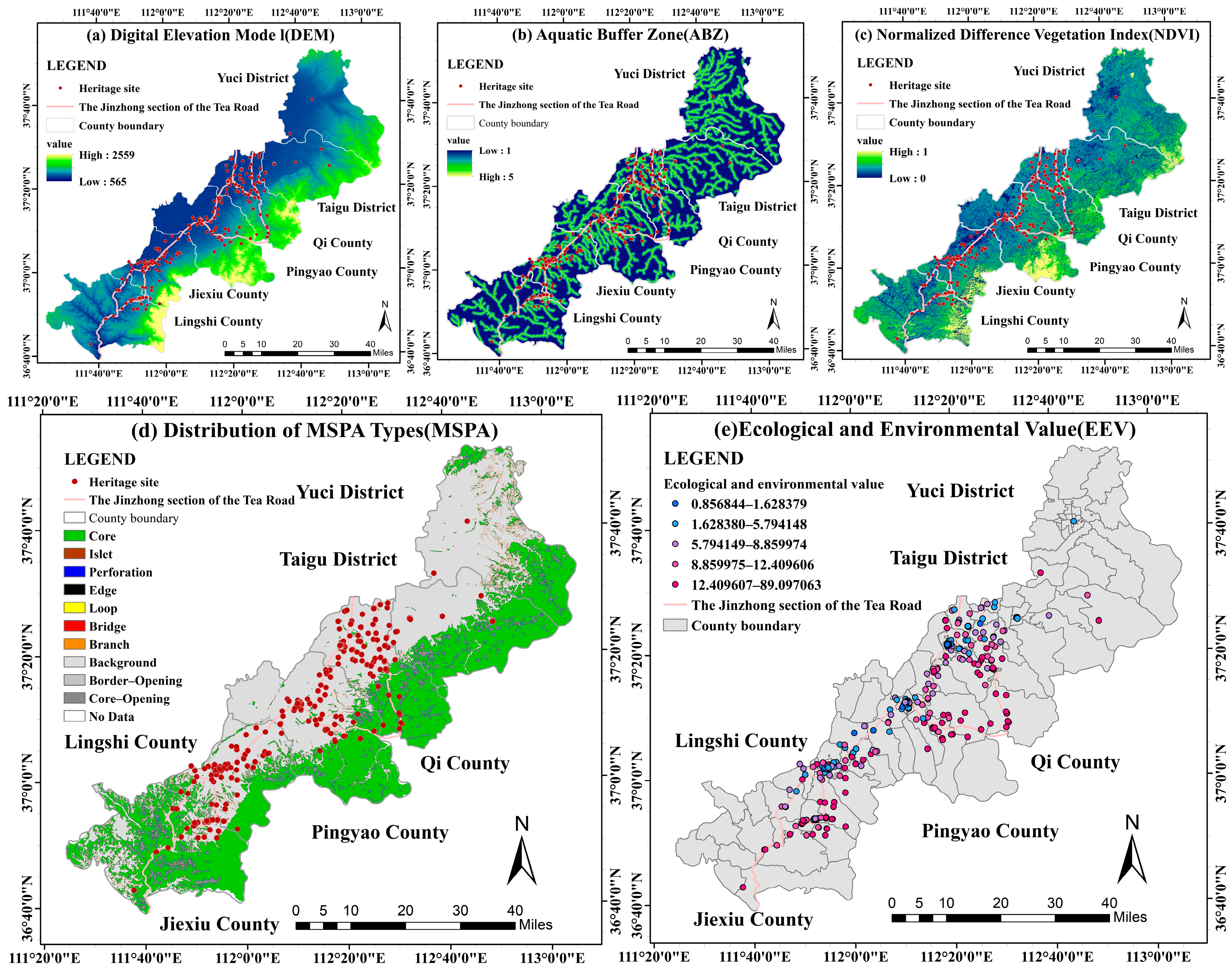


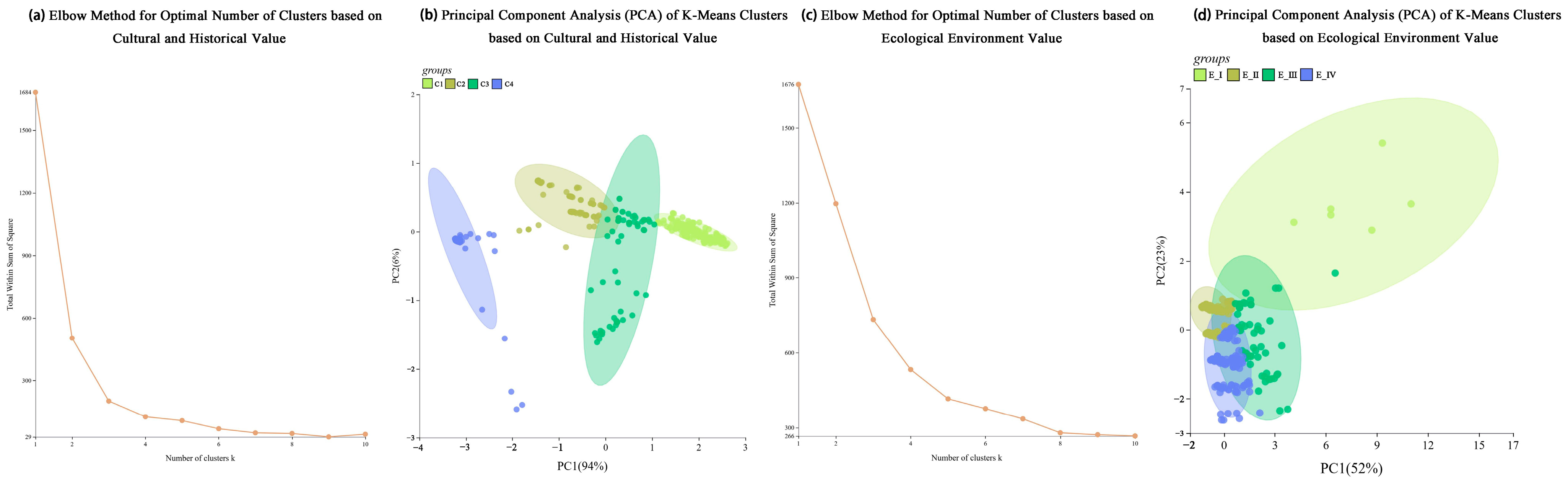


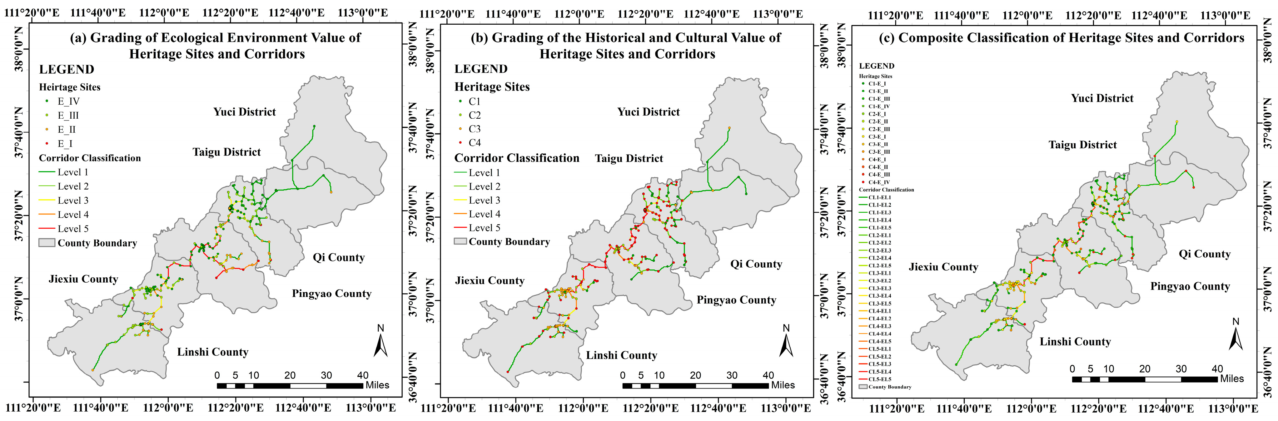

| Value Dimension | Indicator Type | Data Processing Method | Weight |
|---|---|---|---|
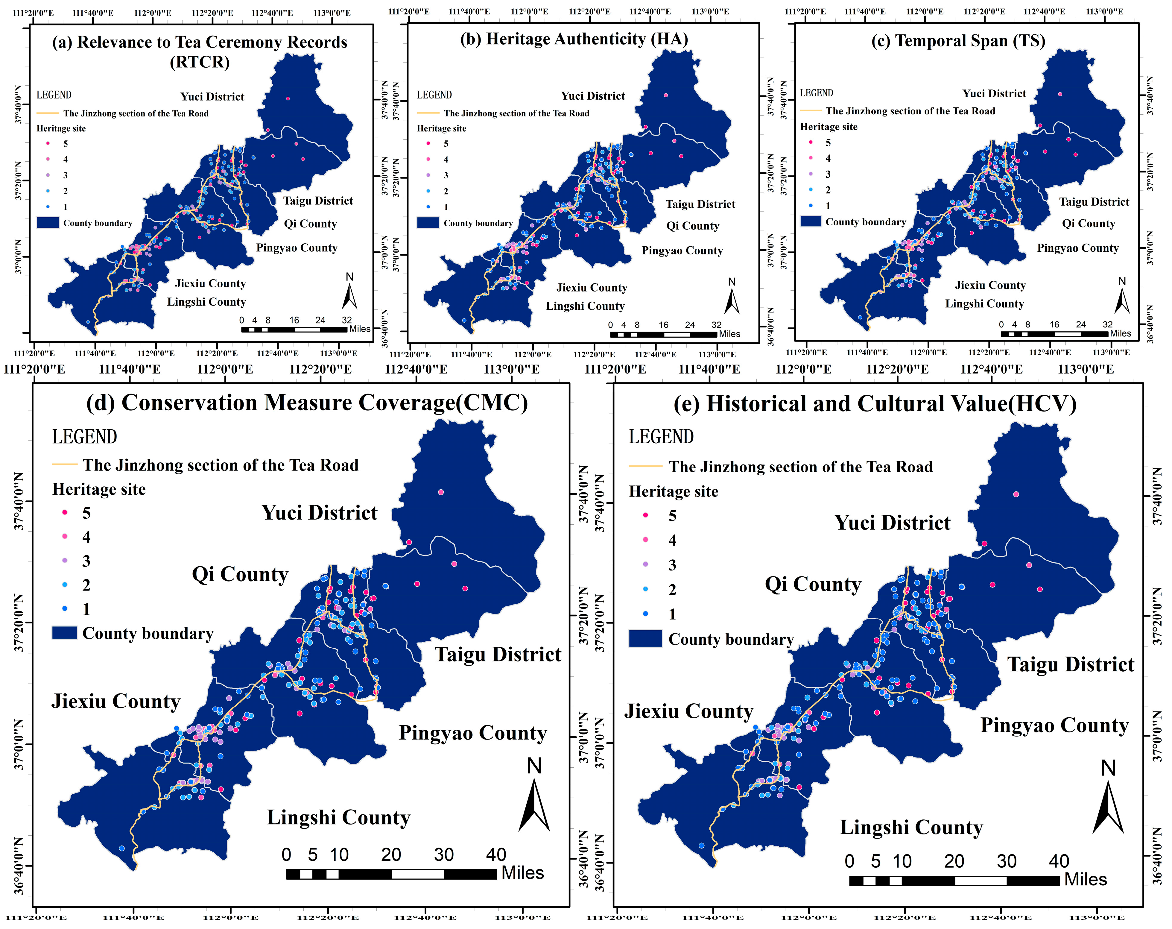
| Historical and cultural value (HCV) | Relevance to Tea Ceremony Records (RTCR) | Scores were assigned to each heritage site and normalised (see Supplementary Material S1 for detailed criteria). | 0.3 |
| Heritage Authenticity (HA) | 0.4 | ||
| Temporal Span (TS) | 0.2 | ||
| Conservation Measure Coverage (CMC) | 0.1 | ||
| Ecological and environmental value (EEV) | Digital Elevation Model (DEM) | Multi-values were extracted to points in ArcGIS10.8 and used as the value indicator. | 0.1 |
| Normalised Difference Vegetation Index (NDVI) | 0.3 | ||
| Aquatic Buffer Zone (ABZ) | 0.1 | ||
| Morphological Spatial Pattern Analysis (MSPA) | MSPA classification based on LULC; core patches were extracted and connectivity indices (IIC, PC, dPC) were calculated to identify ecological source areas. | 0.5 |
| Primary Indicator | Secondary Indicator | Data Source | Data Processing Method | Weight |
|---|---|---|---|---|
| Natural Environment (NE) | Land Use and Land Cover (LULC) | ESA WorldCover: https://esa-worldcover.org/en (accessed on 1 March 2025) | Direct application | 0.0684 |
| Normalised Difference Vegetation Index (NDVI) | NASA Earthdata https://earthdata.nasa.gov/ (accessed on 1 March 2025) | Direct application | 0.1207 | |
| Digital Elevation Model (DEM) | Direct application | 0.0546 | ||
| Slope Gradient (SG) | Derived from processing DEM data | 0.2067 | ||
| Aquatic Buffer Zone (ABZ) | 0.0439 | |||
| Transportation Network (TN) | Vector Road Network (VRN) | OSM road data https://www.openstreetmap.org/ (accessed on 1 March 2025) | Derived using the Euclidean Distance tool in ArcGIS10.8 | 0.1992 |
| Public Services (PS) | Restaurant Services (RSs) | Baidu Map POI open Data https://lbsyun.baidu.com/ (queried and compiled in 1 March 2025) | Derived using the Kernel Density tool in ArcGIS10.8 | 0.0367 |
| Accommodation Services (ASs) | 0.0879 | |||
| Tourist Scenic Areas (TSAs) | 0.0795 | |||
| Cultural Development (CD) | Cultural Enterprise Density (CED) | Baidu Map POI open Data https://lbsyun.baidu.com/ (queried and compiled in 1 March 2025) | Derived using the Kernel Density tool in ArcGIS | 0.0533 |
| Cultural and Educational Institution Density (CEID) | 0.0491 |
| Resistance Factor | Weight | Resistance Value | ||||||
|---|---|---|---|---|---|---|---|---|
| 1 | 2 | 3 | 4 | 5 | ||||
| Natural Environment | Digital Elevation Model (DEM) | 0.4943 | 0.0684 | <0.2 | 0.2–0.4 | 0.4–0.6 | 0.6–0.8 | >0.8 |
| Slope Gradient (SG) | 0.1207 | <8 | 8–15 | 15–25 | 25–45 | >45 | ||
| Normalised Difference Vegetation Index (NDVI) | 0.0546 | <0.40 | 0.40–0.60 | 0.60–0.75 | 0.75–0.85 | >0.85 | ||
| Land Use and Land Cover (LULC) | 0.2067 | Construction Land | Arable Land | Grassland | Water Body | Forest Land | ||
| Aquatic Buffer Zone (ABZ) | 0.0439 | >800 | 600–800 | 400–600 | 200–400 | <200 | ||
| Transportation Networks | Distance From Highway (DFH) | 0.1992 | 0.0654 | <0.5 | 0.5–1 | 1–1.5 | 1.5–2 | >2 |
| Distance From National Road (DFNR) | 0.0479 | <0.5 | 0.5–1 | 1–1.5 | 1.5–2 | >2 | ||
| Distance From Provincial Road (DFPR) | 0.0371 | <0.5 | 0.5–1 | 1–1.5 | 1.5–2 | >2 | ||
| Distance From County Road (DFCR) | 0.0281 | <0.5 | 0.5–1 | 1–1.5 | 1.5–2 | >2 | ||
| Distance From Township Road (DFTR) | 0.0207 | <0.5 | 0.5–1 | 1–1.5 | 1.5–2 | >2 | ||
| Public Services | Restaurant Services (RSs) | 0.2041 | 0.0367 | >18 | 7–18 | 0.5–7 | 0.3–0.5 | <0.3 |
| Accommodation Services (ASs) | 0.0879 | >4 | 2.5–4 | 1.5–2.5 | 0.2–1.5 | <0.2 | ||
| Tourist Scenic Areas (TSAs) | 0.0795 | >0.35 | 0.25–0.35 | 0.15–0.25 | 0.08–0.15 | <0.08 | ||
| Cultural Development | Cultural Enterprise Density (CED) | 0.1024 | 0.0533 | >4 | 2.5–4 | 1.5–2.5 | 0.2–1.5 | <0.2 |
| Cultural and Educational Institution Density (CEID) | 0.0491 | >4 | 2.5–4 | 1.5–2.5 | 0.2–1.5 | <0.2 | ||
Disclaimer/Publisher’s Note: The statements, opinions and data contained in all publications are solely those of the individual author(s) and contributor(s) and not of MDPI and/or the editor(s). MDPI and/or the editor(s) disclaim responsibility for any injury to people or property resulting from any ideas, methods, instructions or products referred to in the content. |
© 2026 by the authors. Licensee MDPI, Basel, Switzerland. This article is an open access article distributed under the terms and conditions of the Creative Commons Attribution (CC BY) license.
Share and Cite
Meng, L.; Zhang, B.; Cao, L. Establishing Linear Cultural Heritage Corridors by Integrating Cultural and Ecological Values: A Case Study of the Jinzhong Section of the Great Tea Road. Land 2026, 15, 293. https://doi.org/10.3390/land15020293
Meng L, Zhang B, Cao L. Establishing Linear Cultural Heritage Corridors by Integrating Cultural and Ecological Values: A Case Study of the Jinzhong Section of the Great Tea Road. Land. 2026; 15(2):293. https://doi.org/10.3390/land15020293
Chicago/Turabian StyleMeng, Lihao, Bolun Zhang, and Lei Cao. 2026. "Establishing Linear Cultural Heritage Corridors by Integrating Cultural and Ecological Values: A Case Study of the Jinzhong Section of the Great Tea Road" Land 15, no. 2: 293. https://doi.org/10.3390/land15020293
APA StyleMeng, L., Zhang, B., & Cao, L. (2026). Establishing Linear Cultural Heritage Corridors by Integrating Cultural and Ecological Values: A Case Study of the Jinzhong Section of the Great Tea Road. Land, 15(2), 293. https://doi.org/10.3390/land15020293