Urban Remote Sensing Ecological Quality Assessment Based on Hierarchical Principal Component Analysis and Water Factor Enhancement: A Case Study of Linyi City, Shandong Province, China

 ,
, 
 , ,
, ,  and
and
Abstract
1. Introduction
2. Materials and Methods
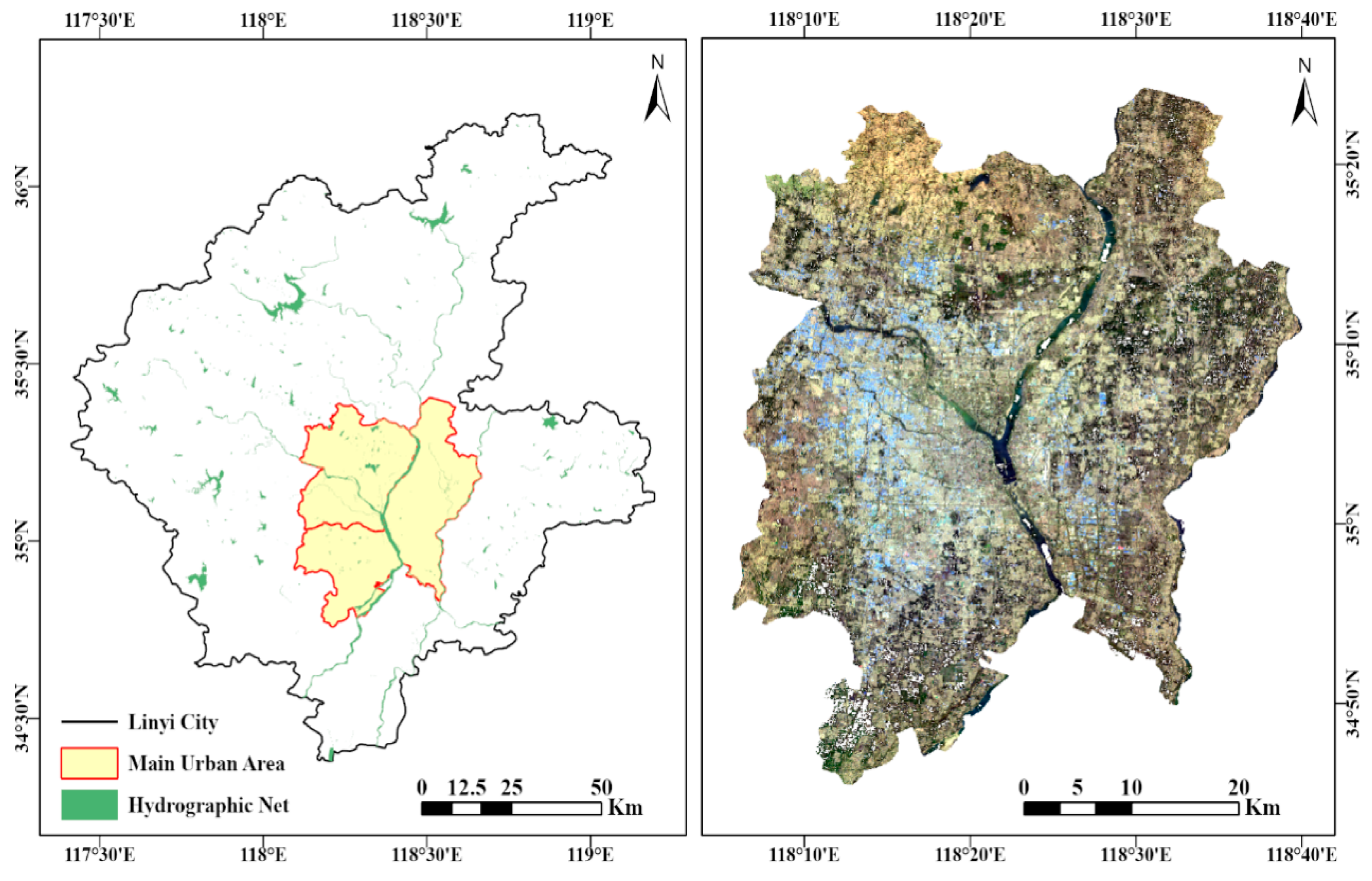
2.1. Study Area
2.2. Data Collection
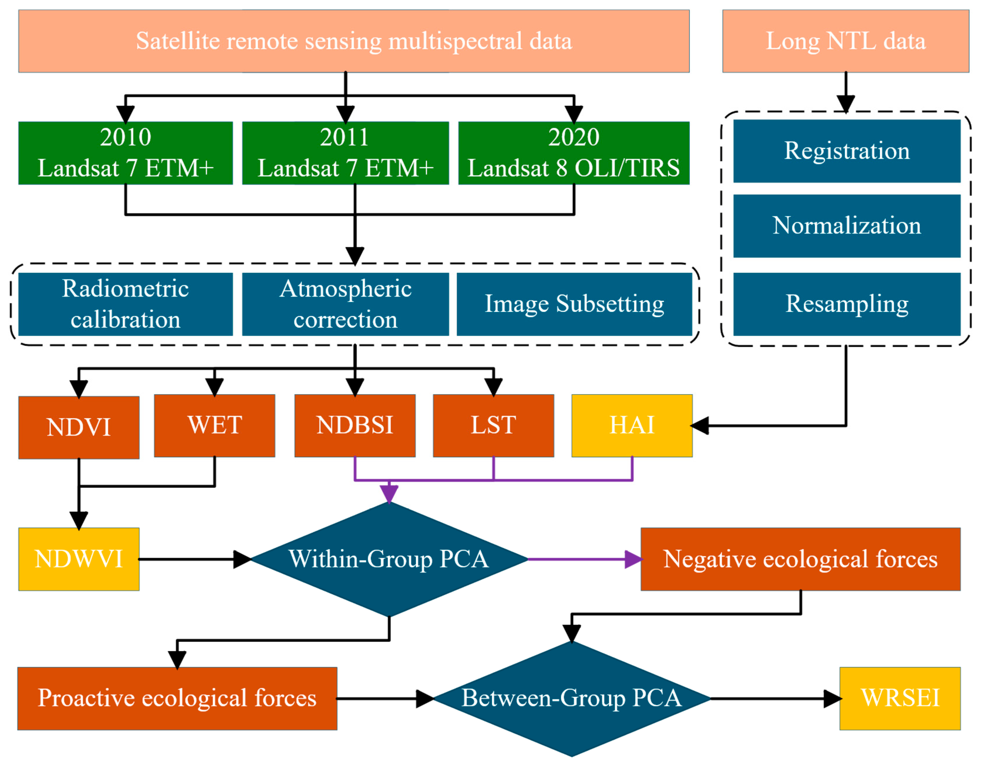
2.3. Methods
2.4. Ecological Index
2.4.1. Wetness
2.4.2. Greenness
2.4.3. Dryness
2.4.4. Heat
2.4.5. Human Activity Index
2.5. Hierarchical Principal Component Analysis
2.5.1. Indicator Grouping
2.5.2. Within-Group PCA
2.5.3. Intergroup PCA
2.5.4. WRSEI Calculation
2.5.5. Hierarchical PCA Weight Calculation and Statistical Outputs
3. Results and Discussion
3.1. Analysis of the Water Factor Enhancement Effect
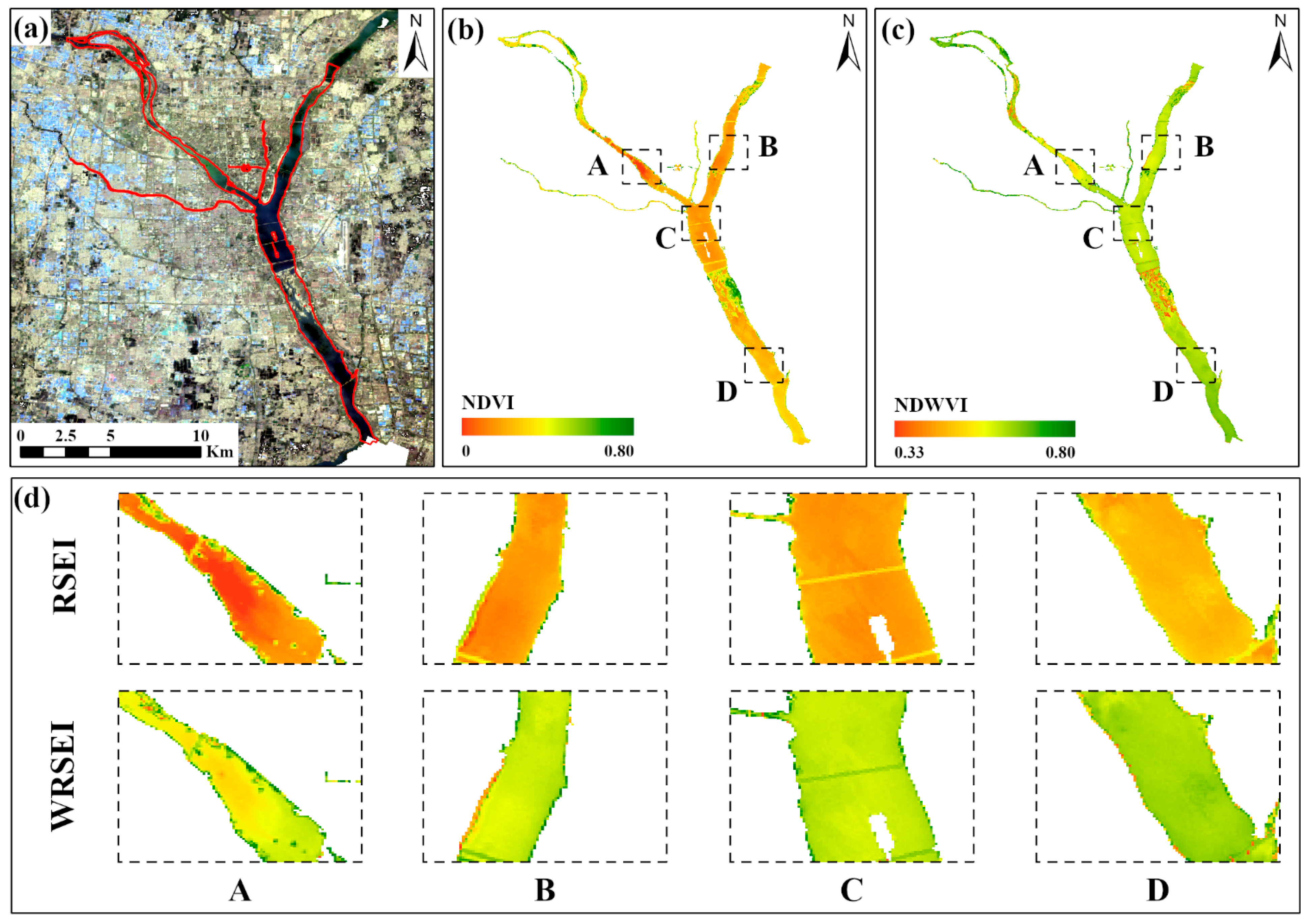
3.1.1. Comparison of Spatial Distribution Characteristics
3.1.2. Comparison of Statistical Distribution Characteristics
3.1.3. Ecological Rationality and Limitations of the Water Enhancement Mechanism
3.1.4. Sensitivity Analysis of LSM Threshold
3.2. Analysis of Contribution of Human Activity Intensity Indicator
3.3. Validation of Model Effectiveness
3.3.1. Comparative Analysis of WRSEI and RSEI
3.3.2. Validation of Index Effectiveness Based on Land Use Types
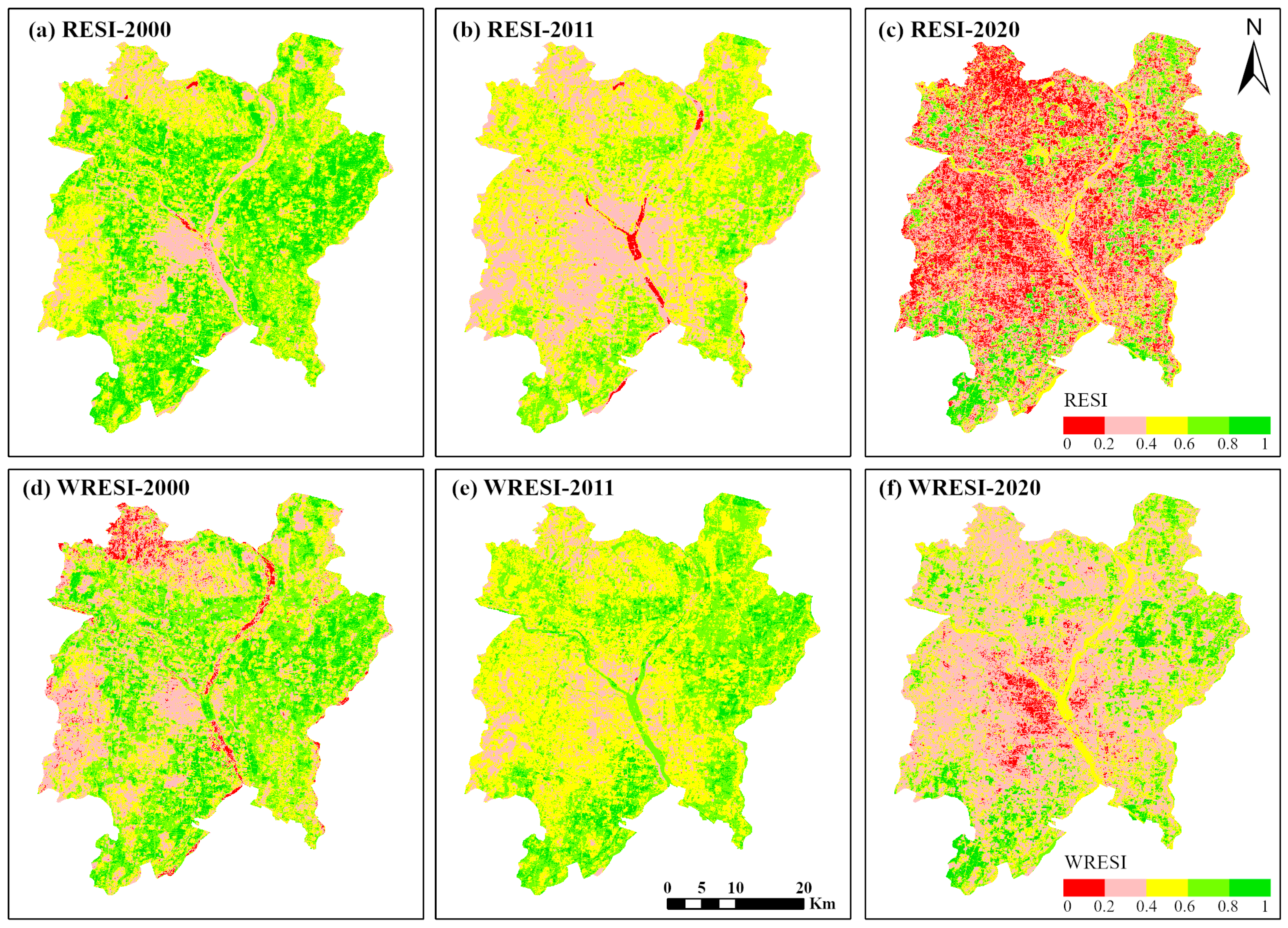
3.4. Spatiotemporal Variation in Ecological Quality in the Main Urban Area of Linyi
4. Conclusions
Author Contributions
Funding
Data Availability Statement
Acknowledgments
Conflicts of Interest
References
- Grimm, N.B.; Faeth, S.H.; Golubiewski, N.E.; Redman, C.L.; Wu, J.; Bai, X.; Briggs, J.M. Global Change and the Ecology of Cities. Science 2008, 319, 756–760. [Google Scholar] [CrossRef] [Scilit] [PubMed]
- Bai, X.; Dawson, R.J.; Ürge-Vorsatz, D.; Delgado, G.C.; Barau, A.S.; Dhakal, S.; Dodman, D.; Leonardsen, L.; Masson-Delmotte, V.; Roberts, D.C.; et al. Linking Urbanization and the Environment: Conceptual and Empirical Advances. Annu. Rev. Environ. Resour. 2017, 42, 215–240. [Google Scholar] [CrossRef] [Scilit]
- Xu, H. A Remote Sensing Index for Assessment of Regional Ecological Changes. China Environ. Sci. 2013, 33, 889–897. (In Chinese) [Google Scholar]
- Boori, M.S.; Choudhary, K.; Paringer, R.; Kupriyanov, A. Spatiotemporal Ecological Vulnerability Analysis with Statistical Correlation Based on Satellite Remote Sensing in Samara, Russia. J. Environ. Manag. 2021, 285, 112–138. [Google Scholar] [CrossRef] [Scilit]
- Hasan, M.M.; Ferdous, M.T.; Talha, M.; Mojumder, P.; Roy, S.K.; Zim, M.N.F.; Akter, M.M.; Nasher, N.M.R.; Hasher, F.F.B.; Boltižiar, M.; et al. Analyzing Ecological Environmental Quality Trends in Dhaka Through Remote Sensing Based Ecological Index (RSEI). Land 2025, 14, 1258. [Google Scholar] [CrossRef] [Scilit]
- Xu, H. Modification of Normalised Difference Water Index (NDWI) to Enhance Open Water Features in Remotely Sensed Imagery. Int. J. Remote Sens. 2006, 27, 3025–3033. [Google Scholar] [CrossRef] [Scilit]
- Xu, H.; Wang, M.; Shi, T.; Guan, H.; Fang, C.; Lin, Z. Detecting Ecological Changes with a Remote Sensing Based Ecological Index (RSEI) Produced Time Series and Change Vector Analysis. Remote Sens. 2019, 11, 2345. [Google Scholar] [CrossRef] [Scilit]
- Bolund, P.; Hunhammar, S. Ecosystem Services in Urban Areas. Ecol. Econ. 1999, 29, 293–301. [Google Scholar] [CrossRef] [Scilit]
- Cai, Z.; Zhang, Z.; Zhao, F.; Bo, L.; Wang, W. Assessment of Eco-Environmental Quality Changes and Spatial Heterogeneity in the Yellow River Delta Based on the Remote Sensing Ecological Index and Geo-Detector Model. Ecol. Inform. 2023, 77, 102203. [Google Scholar] [CrossRef] [Scilit]
- Yu, H.; Liu, D.; Zhang, C.; Liang, S.; Tu, W.; Chen, X. Research on Spatial-Temporal Characteristics and Driving Factors of Urban Development Intensity for Pearl River Delta Region Based on Geodetector. Land 2023, 12, 1673. [Google Scholar] [CrossRef] [Scilit]
- Zhang, L.; Hou, Q.; Duan, Y.; Ma, W. Spatial and Temporal Heterogeneity of Eco-Environmental Quality in Yanhe Watershed (China) Using the Remote-Sensing-Based Ecological Index (RSEI). Land 2024, 13, 780. [Google Scholar] [CrossRef] [Scilit]
- Ji, J.; Tang, Z.; Zhang, W.; Liu, W.; Jin, B.; Xi, X.; Wang, F.; Zhang, R.; Guo, B.; Xu, Z.; et al. Spatiotemporal and Multiscale Analysis of the Coupling Coordination Degree between Economic Development Equality and Eco-Environmental Quality in China from 2001 to 2020. Remote Sens. 2022, 14, 737. [Google Scholar] [CrossRef] [Scilit]
- Hou, L.; Ren, Z.Y.; Wang, L.X.; Zhang, Y. Dynamic Study on Ecological Footprint of Linyi City from 1996 to 2005. J. Shaanxi Norm. Univ. (Nat. Sci. Ed.) 2008, 36, 86–89+95. (In Chinese) [Google Scholar]
- Ni, Z.R.; Ren, G.Y.; Sun, Y.W.; Wang, S.J. Current Situation and Impact Assessment of Urban Ecological Water Conservancy Construction in Linyi City. China Water Resour. 2010, 12, 56–58. (In Chinese) [Google Scholar]
- Li, X.; Zhou, Y.; Zhao, M.; Zhao, X. A Harmonized Global Nighttime Light Dataset 1992–2018. Sci. Data 2020, 7, 168. [Google Scholar] [CrossRef] [Scilit]
- Zhao, M.; Cheng, W.; Zhou, C.; Li, M.; Wang, N.; Liu, Q. A Global Dataset of Annual Urban Extents (1992–2020) from Harmonized Nighttime Lights. Earth Syst. Sci. Data 2022, 14, 517–534. [Google Scholar] [CrossRef] [Scilit]
- Zhou, Y.; Cao, W.; Zhou, J. Dynamic Assessment of Eco-Environmental Quality in Xiong’an New Area, China Using WB-RSEI New Model. Sci. Rep. 2025, 15, 7592. [Google Scholar] [CrossRef] [Scilit] [PubMed]
- Kauth, R.J.; Thomas, G.S. The Tasseled Cap—A Graphic Description of the Spectral-Temporal Development of Agricultural Crops as Seen by Landsat. In Proceedings of the Symposium on Machine Processing of Remotely Sensed Data, West Lafayette, IN, USA, 29 June–1 July 1976; pp. 4B-41–4B-51. [Google Scholar]
- Crist, E.P.; Cicone, R.C. A Physically-Based Transformation of Thematic Mapper Data—The TM Tasseled Cap. IEEE Trans. Geosci. Remote Sens. 1984, GE-22, 256–263. [Google Scholar] [CrossRef] [Scilit]
- Baig, M.H.A.; Zhang, L.; Shuai, T.; Tong, Q. Derivation of a Tasselled Cap Transformation Based on Landsat 8 At-Satellite Reflectance. Remote Sens. Lett. 2014, 5, 423–431. [Google Scholar] [CrossRef] [Scilit]
- Tucker, C.J. Red and Photographic Infrared Linear Combinations for Monitoring Vegetation. Remote Sens. Environ. 1979, 8, 127–150. [Google Scholar] [CrossRef] [Scilit]
- Pettorelli, N.; Vik, J.O.; Mysterud, A.; Gaillard, J.M.; Tucker, C.J.; Stenseth, N.C. Using the Satellite-Derived NDVI to Assess Ecological Responses to Environmental Change. Trends Ecol. Evol. 2005, 20, 503–510. [Google Scholar] [CrossRef] [Scilit]
- Xu, H.; Deng, W. Rationality Analysis of the MRSEI and Its Difference from the RSEI. Remote Sens. Technol. Appl. 2022, 37, 1–7. [Google Scholar]
- Rikimaru, A.; Roy, P.S.; Miyatake, S. Tropical Forest Cover Density Mapping. Trop. Ecol. 2002, 43, 39–47. [Google Scholar]
- Wu, C.; Liu, H.; Meng, C.; Li., X.; Gan, D. Assessing ecological environmental quality and conservation effectiveness in the World’s largest urban green heart using the remote sensing ecological index (RSEI) and propensity score matching (PSM). Front. Environ. Sci. 2025, 13, 1626195. [Google Scholar] [CrossRef] [Scilit]
- Artis, D.A.; Carnahan, W.H. Survey of Emissivity Variability in Thermography of Urban Areas. Remote Sens. Environ. 1982, 12, 313–329. [Google Scholar] [CrossRef] [Scilit]
- Sobrino, J.A.; Jiménez-Muñoz, J.C.; Paolini, L. Land Surface Temperature Retrieval from LANDSAT TM 5. Remote Sens. Environ. 2004, 90, 434–440. [Google Scholar] [CrossRef] [Scilit]
- Jiménez-Muñoz, J.C.; Sobrino, J.A.; Skoković, D.; Mattar, C.; Cristóbal, J. Land Surface Temperature Retrieval Methods from Landsat-8 Thermal Infrared Sensor Data. IEEE Geosci. Remote Sens. Lett. 2014, 11, 1840–1843. [Google Scholar] [CrossRef] [Scilit]
- Li, X.; Zhao, L.; Li, D.; Xu, H. Automatic Intercalibration of Night-Time Light Imagery Using Robust Regression. Remote Sens. Lett. 2013, 4, 46–55. [Google Scholar] [CrossRef] [Scilit]
- Zheng, Q.; Seto, K.C.; Zhou, Y.; You, S.; Weng, Q. Nighttime Light Remote Sensing for Urban Applications: Progress, Challenges, and Prospects. ISPRS J. Photogramm. Remote Sens. 2023, 202, 125–141. [Google Scholar] [CrossRef] [Scilit]
- Jia, Y.; Wu, C.; Ying, X.; Meng, Q. Analysis of spatiotemporal evolution characteristics and driving forces of ecological environment quality in Xichang city based on RSEI and geodetector. Ind. Miner. Process. 2024, 53, 79–88. [Google Scholar] [CrossRef]
- Xu, H.; Li, C.; Lin, M. Should RSEI Use PCA or kPCA? Geom. Inf. Sci. Wuhan Univ. 2023, 48, 506–513. [Google Scholar] [CrossRef]
- Jolliffe, I.T. Principal Component Analysis, 2nd ed.; Springer: New York, NY, USA, 2002. [Google Scholar]
- Jolliffe, I.T.; Cadima, J. Principal Component Analysis: A Review and Recent Developments. Philos. Trans. R. Soc. A 2016, 374, 20150202. [Google Scholar] [CrossRef] [Scilit] [PubMed]
- Ren, X.; Yan, F.; Wang, Y.; Wang, Z.; Wang, H. A Water-Adapted Remote Sensing Ecological Index for Water Body Ecological Quality Assessment. Remote Sens. 2022, 14, 4289. [Google Scholar] [CrossRef] [Scilit]
- Zhang, P.; Qi, S.; Lai, J.; Wang, M.; Guo, Y.; Ma, L.; Liu, S. Spatiotemporal Changes and Driving Factors of Ecological Quality in the Jinsha River Basin Based on RSEI. Environ. Sci. 2026, 47, 408–419. (In Chinese) [Google Scholar] [CrossRef] [Scilit]
- Nițu, A.; Florea, C.; Ivanovici, M. NDVI and Beyond: Vegetation Indices as Features for Crop Recognition and Segmentation in Hyperspectral Data. Sensors 2025, 25, 3817. [Google Scholar] [CrossRef] [Scilit]
- Wu, M.; Li, Y. Spatial-temporal Evolution and Driving Factors of Ecological Environment Quality in Weihe River Basin Based on Remote Sensing Ecological Index. E3S Web Conf. 2025, 630, 02003. [Google Scholar] [CrossRef] [Scilit]
- De Groot, R.S.; Wilson, M.A.; Boumans, R.M.J. A Typology for the Classification, Description and Valuation of Ecosystem Functions, Goods and Services. Ecol. Econ. 2002, 41, 393–408. [Google Scholar] [CrossRef] [Scilit]
- Chen, Y.; Liu, A.; Zhang, Z.; Wang, Y.; Li, M. Sensitivity of Landsat Scale Data in Seasonal Land Cover Classification over Central Europe. Remote Sens. 2023, 15, 1234. [Google Scholar] [CrossRef] [Scilit]
- Rhif, M.; Ben Abbes, A.; Martinez, B.; de Jong, R.; Sang, Y.; Farah, I.R. Detection of Trend and Seasonal Changes in Non-Stationary Remote Sensing Data: Case Study of Tunisia Vegetation Dynamics. Ecol. Inform. 2022, 69, 101596. [Google Scholar] [CrossRef] [Scilit]




| Satellite | Acquisition Date | Cloud Cover | Bands | Processing Level |
|---|---|---|---|---|
| Landsat 7 ETM+ | May 2000 | 0.00 | 8 | L2SP |
| Landsat 7 ETM+ | May 2011 | 4.00 | 8 | L2SP |
| Landsat 8 OLI/TIRS | May 2020 | 3.59 | 11 | L2SP |
| RSEI | WRSEI | ||
|---|---|---|---|
| Indicator | Metric | Indicator | Metric |
| Wetness | LSM_nor | Wetness | LSM_nor |
| Green | NDVI_nor | Green | NDWVI_nor |
| Dryness | NDBSI | Dryness | NDBSI |
| Heat | LST_nor | Heat | LST_nor |
| HAI | NTL_nor | ||
| Statistical Item | Ecological Endowment Group (PC1a) | Ecological Stress Group (PC1b) | Intergroup PCA (PC1_Final) |
|---|---|---|---|
| Variables/Components | NDWVI, wetness | NDBSI, heat, NTL | PC1a, PC1b |
| Eigenvalue (λ) | 0.1037 | 1.5922 | 1.5448 |
| Variance Explained (%) | 98.58 | 53.07 | 77.24 |
| Cumulative Variance (%) | 98.58 | 53.07 | 77.24 |
| Component Loadings: | |||
| NDWVI | 0.9555 | — | — |
| Wetness | −0.2949 | — | — |
| NDBSI | — | −0.6519 | — |
| Heat | — | −0.6797 | — |
| NTL | — | −0.3361 | — |
| PC1a (Synthetic) | — | — | 0.7071 |
| PC1b (Synthetic) | — | — | 0.7071 |
| Information Retention Rate * | 98.58% | 53.07% | 77.24% |
| Indicator | Ecological Category | Within-Group Loading (PC1a/PC1b) | Intergroup Loading (PC1_Final) | Raw Combined Weight | Final Normalized Weight (%) |
|---|---|---|---|---|---|
| NDWVI | Ecological Endowment | 0.9555 | 0.7071 | 0.6755 | 33.92 |
| Wetness | Ecological Endowment | –0.2949 | 0.7071 | –0.2085 | 10.46 |
| NDBSI | Ecological Stress | –0.6519 | 0.7071 | –0.4608 | 23.13 |
| Heat | Ecological Stress | –0.6797 | 0.7071 | –0.4805 | 24.12 |
| NTL | Ecological Stress | –0.3361 | 0.7071 | –0.2376 | 11.93 |
| Total | 99.56 |
| Index | Min | Max | Mean | Std |
|---|---|---|---|---|
| NDVI_nor | 0.00 | 0.82 | 0.31 | 0.11 |
| NDWVI | 0.33 | 0.82 | 0.57 | 0.05 |
| RSEI | 0.06 | 0.78 | 0.38 | 0.09 |
| WRSEI | 0.00 | 0.79 | 0.44 | 0.12 |
| LSM Threshold | Water Area (ha) | Area Proportion (%) * | Mean WRSEI | Ecological Characterization |
|---|---|---|---|---|
| 0.7 | 115,289.02 | 59.49 | 0.257 | Contains extensive moist non-water surfaces |
| 0.75 | 25,493.94 | 13.15 | 0.293 | Still exhibits overinclusion |
| 0.8 | 9779.13 | 5.05 | 0.482 | Optimal balance state |
| 0.85 | 6724.08 | 3.47 | 0.516 | Highest ecological quality but insufficient area |
| 0.9 | 3.33 | <0.01 | 0.271 | Omits important ecological water bodies |
| Land Use Type | RSEI | WRSEI | ||||||
|---|---|---|---|---|---|---|---|---|
| Min | Max | Mean | Variance | Min | Max | Mean | Variance | |
| Agricultural Land | 0.05 | 1.00 | 0.44 | 0.24 | 0.00 | 1.00 | 0.47 | 0.25 |
| Water Bodies | 0.06 | 0.87 | 0.42 | 0.10 | 0.00 | 0.88 | 0.48 | 0.13 |
| Forests and Grassland | 0.08 | 0.97 | 0.41 | 0.20 | 0.00 | 1.00 | 0.42 | 0.22 |
| Construction Land | 0.00 | 0.80 | 0.27 | 0.13 | 0.00 | 1.00 | 0.24 | 0.15 |
| Unused Land | 0.07 | 0.88 | 0.31 | 0.15 | 0.00 | 0.94 | 0.34 | 0.18 |
| Year | WRSEI Value | WRSEI Class (%) | |||||
|---|---|---|---|---|---|---|---|
| Mean | Std | Very Low | Low | Moderate | High | Very High | |
| 2000 | 0.47 | 0.20 | 9.34 | 27.90 | 37.67 | 20.24 | 4.85 |
| 2011 | 0.43 | 0.24 | 19.62 | 32.17 | 22.54 | 17.19 | 8.48 |
| 2020 | 0.36 | 0.24 | 31.75 | 34.18 | 18.14 | 8.66 | 7.27 |
Disclaimer/Publisher’s Note: The statements, opinions and data contained in all publications are solely those of the individual author(s) and contributor(s) and not of MDPI and/or the editor(s). MDPI and/or the editor(s) disclaim responsibility for any injury to people or property resulting from any ideas, methods, instructions or products referred to in the content. |
© 2026 by the authors. Licensee MDPI, Basel, Switzerland. This article is an open access article distributed under the terms and conditions of the Creative Commons Attribution (CC BY) license.
Share and Cite
Liu, X.; Liu, X.; Zheng, X.; Liu, X.; Yu, G.; Jiang, F.; Liu, K. Urban Remote Sensing Ecological Quality Assessment Based on Hierarchical Principal Component Analysis and Water Factor Enhancement: A Case Study of Linyi City, Shandong Province, China. Land 2026, 15, 196. https://doi.org/10.3390/land15010196
Liu X, Liu X, Zheng X, Liu X, Yu G, Jiang F, Liu K. Urban Remote Sensing Ecological Quality Assessment Based on Hierarchical Principal Component Analysis and Water Factor Enhancement: A Case Study of Linyi City, Shandong Province, China. Land. 2026; 15(1):196. https://doi.org/10.3390/land15010196
Chicago/Turabian StyleLiu, Xiaocai, Xianglong Liu, Xinqi Zheng, Xiaoyang Liu, Guangting Yu, Fei Jiang, and Kun Liu. 2026. "Urban Remote Sensing Ecological Quality Assessment Based on Hierarchical Principal Component Analysis and Water Factor Enhancement: A Case Study of Linyi City, Shandong Province, China" Land 15, no. 1: 196. https://doi.org/10.3390/land15010196
APA StyleLiu, X., Liu, X., Zheng, X., Liu, X., Yu, G., Jiang, F., & Liu, K. (2026). Urban Remote Sensing Ecological Quality Assessment Based on Hierarchical Principal Component Analysis and Water Factor Enhancement: A Case Study of Linyi City, Shandong Province, China. Land, 15(1), 196. https://doi.org/10.3390/land15010196