Article

Evaluating the EDUS Point Prototype Through an Urban Living Lab: Temporary Urban Intervention in Barcelona


by
Fanny E. Berigüete Alcántara
1,
José S. Santos Castillo
2,
Julián Galindo González
3,
Inmaculada R. Cantalapiedra
4,* and
Miguel Y. Mayorga Cárdenas
3,*
1
Interdisciplinary Group on Building Science and Technology GICITED, Universitat Politècnica de Catalunya UPC, 08028 Barcelona, Spain
2
University Research Institute for Sustainability Science and Technology, Universitat Politècnica de Catalunya UPC, 08034 Barcelona, Spain
3
Department of Urban Planning, Territory and Landscape DUTP, Barcelona Urban Planning Laboratory LUB, Universitat Politècnica de Catalunya UPC, 08028 Barcelona, Spain
4
Department of Physics, Universitat Politècnica de Catalunya UPC, 08028 Barcelona, Spain
*
Authors to whom correspondence should be addressed.
Land 2026, 15(1), 150; https://doi.org/10.3390/land15010150
Submission received: 2 November 2025 / Revised: 20 December 2025 / Accepted: 5 January 2026 / Published: 11 January 2026

Abstract

Urban public spaces increasingly need to address inclusivity, adaptability, and resilience in the face of health, environmental, and social challenges. Urban policies also promote improving the relationship between schools and their surroundings to mitigate and adapt to climate and social risks. This article presents EDUS Point, an experimental prototype developed within the European project FURNISH and tested in Barcelona during the COVID-19 crisis. Conceived as an Urban Living Lab (ULL), the initiative explored how modular, digitally fabricated, and temporary structures could transform school environments into open, inclusive, and human-scale public spaces. Through an inter-scalar and interdisciplinary approach, the project implemented an urban strategy, a participatory community-building process, and a digital collective platform, alongside the design, fabrication, and testing of a pilot classroom device adaptable and replicable in other schools. A mixed-methods methodology combined tactical urbanism and co-design with fabrication feasibility assessments, social observations, and spatial impact analysis. Results demonstrate that EDUS Point fostered new socio-spatial dynamics among students, teachers, and residents, improved accessibility and usability of nearby public spaces, and validated the effectiveness of low-cost, rapidly deployable interventions in addressing urban needs. The findings propose actionable frameworks, tools, and design criteria for the socio-environmental integration of schools as catalysts for inclusive and resilient urban transformation.

1. Introduction

Public spaces are essential components of urban life, shaping how people interact, form community ties, and experience their cities. They provide arenas not only for leisure and mobility but also for social cohesion, well-being, and democratic expression [1,2]. Yet, in the early 21st century, the role of public space has been put under unprecedented pressure. The COVID-19 pandemic revealed the limitations of many urban environments and accelerated the need for safe, adaptable, inclusive, and high-quality outdoor spaces [3]. While the immediate health emergency has passed, the spatial and social lessons derived from that period remain relevant for contemporary environmental, social, and public health challenges. Simultaneously, climate change and persistent socio-spatial inequalities have reinforced the urgency of rethinking public space design to address both environmental resilience and social justice [4].
In this context, the call for human-scale urbanism has gained renewed relevance. Human-scale approaches emphasise accessibility, inclusivity, and adaptability to improve quality of life in dense cities [1]. During the pandemic, public debates and research highlighted the need for streets, squares, and neighbourhood facilities to accommodate social distancing, outdoor learning, and new mobility patterns [5,6,7]. These discussions have reinforced the value of flexible public infrastructures capable of supporting diverse community uses beyond crisis situations.
Over the past two decades, Urban Living Labs (ULLs) have emerged in Europe as platforms to experiment with these challenges. Initially developed in the field of digital innovation, ULLs have expanded to urban sustainability, providing real-life arenas where municipalities, researchers, civil society, and businesses co-design, test, and evaluate new solutions [8,9]. They enable transdisciplinary collaboration and citizen participation, bridging theory and practice while generating place-based knowledge. While ULLs have been widely applied to mobility, climate adaptation and public-space transformation, there is still limited empirical evidence on how temporary, digitally fabricated urban prototypes perform when tested in real-life contexts, particularly in sensitive community interfaces such as school–street environments. However, systematic evaluations of such temporary prototypes remain scarce, especially regarding their feasibility, patterns of use, and spatial effects.
Schools represent a particularly strategic yet underutilised type of urban infrastructure. Traditionally conceived as closed institutions, their surrounding spaces are often dominated by traffic or underused facilities. However, research shows that school environments can serve as anchors of neighbourhood resilience, offering opportunities for social interaction, physical activity, and environmental improvement [10,11,12]. By opening schools to the city and treating them as civic infrastructure, municipalities can simultaneously address educational, social, and urban challenges. Recent approaches to proximity urbanism and child-friendly planning reinforce the importance of strengthening these school–street interfaces, yet little is known about how temporary prototypes can activate them or shape their socio-spatial dynamics [13,14,15].
Against this background, this article examines the EDUS Point (Educational Expanded Dispositive for Urban Space & Community Networking) prototype, an experimental prototype developed within FURNISH (Fast Urban Responses for New Inclusive Spaces and Habitat), a European-funded initiative focused on rapid, small-scale interventions to activate public spaces through digital fabrication and participatory urban design [16]. FURNISH integrates co-creation, CNC-based fabrication, and real-life testing through ULLs, providing a structured methodology to evaluate the feasibility, social impact, and spatial performance of temporary urban prototypes [17]. The EDUS Point was implemented and evaluated in a school–street environment in Barcelona, where it functioned as a modular, digitally fabricated dispositif designed to activate the interface between the educational facility and its surrounding public space [18].
To address the lack of empirical evidence on temporary, digitally fabricated interventions, this study evaluates the EDUS Point prototype through a multidimensional framework that examines (1) its feasibility—considering material behaviour, fabrication, assembly and operational performance; (2) its social impact—focused on patterns of use, interaction, and user perception; and (3) its spatial impact—analysing changes in flows, permanence, and spatial activation.
Accordingly, the article asks what insights does the ULL deployment of the EDUS Point prototype offer regarding the feasibility, social use, and spatial activation of school–street public spaces? By situating this evaluation within a ULL methodology, the study contributes new evidence to ongoing debates on tactical urbanism, digitally fabricated prototypes and human-scale, community-centred public-space transformation.
This paper follows a general-to-specific analytical logic. It first introduces the conceptual and theoretical context of Urban Living Labs and temporary urban interventions, then situates the FURNISH European project as the overarching framework, and finally focuses on the EDUS Point prototype as a concrete case study for evaluation.

2. Theorical Framework

In contemporary urban studies, ephemeral and “liquid” architecture have become relevant frameworks for thinking design as process and adaptation rather than as fixed object. Authors such as Tschumi [19] and Wigley [20] discuss architecture’s temporal and performative capacities; the notion of ontogenesis emphasises the continual becoming of space rather than static form. In this study, these ideas are mobilised to inform EDUS Point’s design logic: modularity, reversibility, easy reconfiguration, and an emphasis on process (assembly, testing, iteration)—features that are directly operationalised within the feasibility dimension of our evaluation (assembly time, transportability, material behaviour). Within this conceptual frame, EDUS Point was conceived as a modular, digitally fabricated prototype designed to be assembled, disassembled, relocated, and tested in real urban conditions. Its design translates abstract notions of temporality and process into concrete operational features that can be empirically observed and evaluated.
Tactical urbanism provides a complementary, practice-oriented lens. Lydon and Garcia [21] define it as “short-term action for long-term change,” emphasising flexibility, community engagement, and the ability to prototype future urban transformations. Silva [22] highlights tactical urbanism as part of an “evolutionary” approach to planning, where interventions are not isolated but contribute to incremental change. Yet, debates around tactical urbanism point to its dual nature: while some scholars celebrate its democratic and experimental character [23], others argue that it risks being co-opted by institutions as a form of “DIY neoliberalism” that offloads responsibility to citizens without structural change [24]. These tensions are particularly evident in European contexts, where municipal governments have increasingly institutionalised tactical practices within broader policy frameworks. Here, tactical urbanism is approached as an experimental mode of intervention whose outcomes require empirical evaluation rather than as a normative planning solution.
Closely related to these debates is the paradigm of proximity urbanism. Popularised by Moreno et al. [13] through the notion of the “15-min city,” proximity-based planning advocates for multifunctional local environments where daily needs can be met within short walking or cycling distances. While not new—it resonates with Jane Jacobs’ [25] emphasis on neighbourhood diversity and Lerner’s [26] notion of “urban acupuncture”—the COVID-19 pandemic accelerated the urgency of rethinking urban proximity as a matter of public health, equity, and resilience. Critics, however, note that while proximity models can improve accessibility and sustainability, they risk reinforcing socio-spatial inequalities if not accompanied by redistributive policies [27]. References to the “15-min city” are therefore used solely to frame proximity at the neighbourhood scale, rather than to address broader questions of urban accessibility or metropolitan planning. Within this debate, schools can be understood as neighbourhood-scale anchors of proximity, as they are distributed across the urban fabric, embedded in neighbourhood life, and hold the potential to catalyse civic uses beyond their educational function [28].
Recent literature on school streets, youth-friendly cities, and learning-oriented public spaces further informs this framework. Studies on school streets highlight the potential of traffic-calmed environments to improve safety and everyday use of the public realm by young people, while also creating conditions that may support social interaction and place appropriation [29,30,31]. Research on youth-friendly public space emphasises the importance of providing adolescents with semi-structured environments that support autonomy, socialisation, and informal learning beyond childhood-focused design paradigms [32,33,34]. Similarly, work on outdoor learning and schoolyard design underlines how educational spaces can extend into the public realm, blurring boundaries between learning, play, and civic life [35,36,37]. Together, this literature positions school–street interfaces as critical sites where spatial design, youth practices, and public space governance intersect.
At a more systemic level, ULLs have been promoted in Europe as governance models for innovation in sustainability and urban resilience. Voytenko et al. [8] describe ULLs as “arenas for innovation” where municipalities, research institutions, civil society, and businesses collaboratively test new solutions in real-life contexts. Steen and van Bueren [9] argue that the defining characteristics of ULLs include experimentation, participation, and multi-stakeholder collaboration. These labs challenge traditional planning by embedding experimentation within everyday settings, enabling iterative feedback loops between users and designers. However, concerns persist regarding the inclusivity and representativeness of ULLs [38], particularly about who decides, who benefits, and who is excluded. These critiques underline the importance of combining ULL experimentation with transparent evaluation criteria and explicit acknowledgement of limitations.
Participation itself is subject to multiple interpretations. In the design field, “participatory design” has a long history, particularly in Scandinavia, where it was originally associated with workplace democracy in the 1970s [39]. The term generally refers to the involvement of users in design processes, ensuring that their perspectives influence outcomes. By contrast, “co-design” is often used to describe more intensive forms of collaboration in which experts and non-experts work on equal footing to generate solutions [40]. In the context of ULLs, both terms are used, but scholars’ debate whether co-design represents a substantive difference or simply a rebranding of participatory traditions [41]. For projects like EDUS Point, where local communities, students, and designers collaborated on prototyping school environments, the terminology of participatory design captures the integration of citizens into design processes, without assuming equal involvement across all phases of design and evaluation.
A further layer of contemporary debate concerns the role of digital tools and data-driven approaches in shaping public spaces. Smart city discourses have popularised the use of technologies such as digital twins, predictive analytics, and sensor networks for urban management [42,43,44]. Proponents argue that such tools increase efficiency and evidence-based decision-making, while critics warn of technocratic and exclusionary dynamics [45]. Alternative perspectives emphasise the potential of citizen science and volunteered geographic information [46,47] to democratise knowledge production. By engaging communities in data collection and mapping, these approaches reframe urban monitoring as a participatory process rather than a top-down imposition. Examples such as the Carer Cities interactive platform [48] demonstrate how participatory mapping can visualise school surroundings, allowing diverse stakeholders to document experiences and evaluate interventions collectively. These practices align with broader debates on data justice, which argue for more equitable and transparent forms of digital participation [49].
Bringing these strands together, the theoretical framework situates EDUS Point at the intersection of three key debates. First, tactical urbanism provides the methodological lens for temporary, experimental, small-scale, low-cost interventions whose impacts must be empirically assessed. Second, ULLs supply the governance model for collaborative experimentation, linking schools, universities, municipalities, and communities. Third, digital and participatory tools extend these practices into new forms of knowledge creation, integrating citizen perspectives into the evaluation of public space. Together with insights from school–street and youth-friendly public space literature, this synthesis informs the three evaluation dimensions adopted in this study—feasibility, social impact, and spatial impact—providing a coherent theoretical foundation for the empirical analysis that follows.

3. The FURNISH Project: Framework and Methodological Context

The EDUS Point prototype was developed within the framework of FURNISH (Fast Urban Responses for New Inclusive Spaces and Habitat), a European project funded under the EIT Urban Mobility programme. FURNISH was conceived to explore agile and experimental responses to the growing need for safer, more inclusive, and adaptable public spaces under conditions of uncertainty and rapid urban change. Although the project emerged during the COVID-19 pandemic, its scope extends beyond this specific context, aiming to generate transferable knowledge on temporary and small-scale urban interventions applicable to a wide range of urban challenges.
The main objective of FURNISH was to design, deploy, and test temporary urban prototypes capable of reconfiguring public space at the human scale through rapid design–build processes and digital fabrication. More specifically, the project sought to:
(i) Experiment with agile urban design processes based on CNC fabrication and modular construction;
(ii) Promote participatory approaches by involving local communities, designers, researchers, and public administrations;
(iii) Explore the feasibility and performance of temporary urban elements in real-life contexts; and
(iv) Enable comparative analysis across multiple European cities.
To achieve these objectives, FURNISH implemented seven pilot interventions, referred to as Mobile Urban Elements (MUEs), across five European cities: Guimarães, Espoo, Budapest, Milan, and Barcelona. Each prototype addressed a distinct urban context—such as mobility, public space activation, or educational environments—while sharing a common development framework.

3.1. ULL Design and Implementation Framework

FURNISH adopted the ULL approach as its guiding framework, understood as a real-life experimentation environment in which municipalities, research institutions, designers, and citizens collaboratively conceive, test, and refine urban solutions in situ.
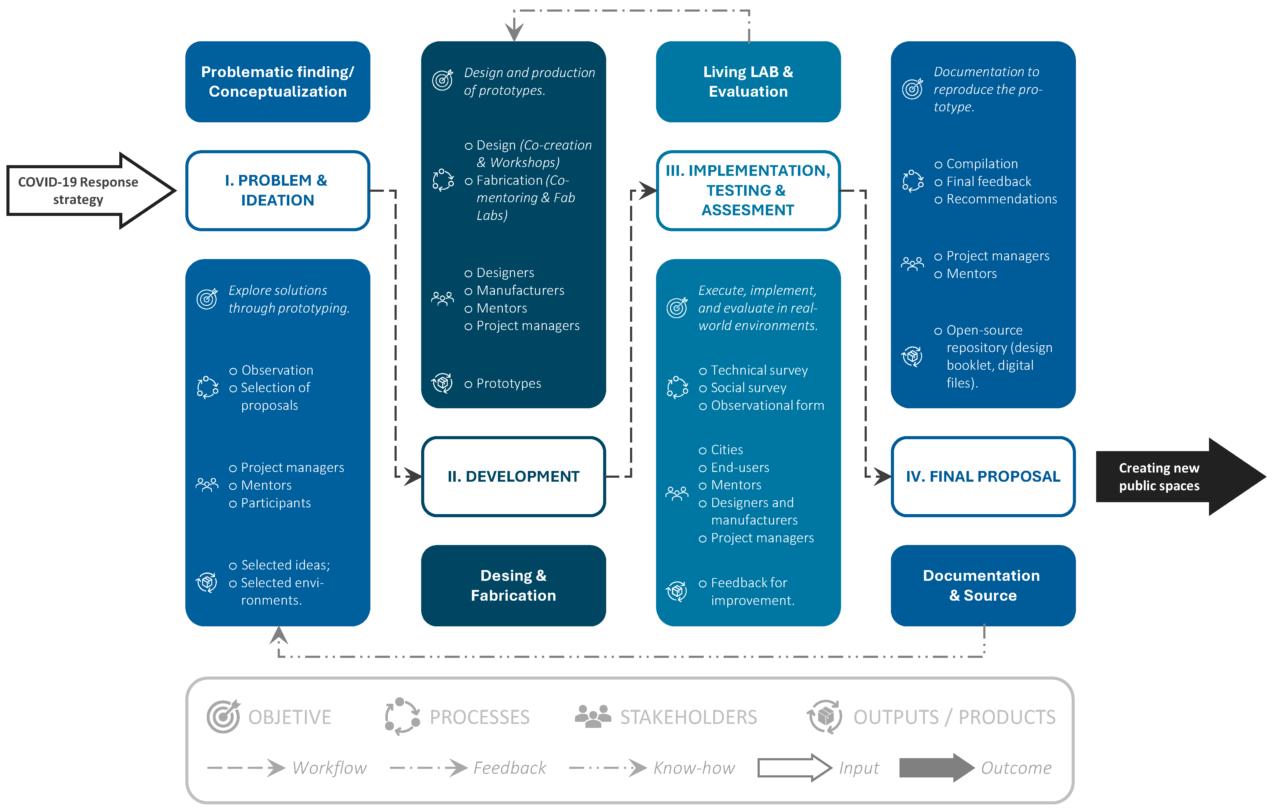
Within the FURNISH project, the ULL approach was structured through a four-phase model (problem and ideation, development, implementation/testing/assessment, and final proposal) previously developed and discussed as an assessment methodology for urban design in uncertain conditions in Aquilué et al. [17]. This model emphasises iterative learning, overlaps between phases, and the integration of social and spatial feedback during prototyping processes (Figure 1).
The first phase, problem and ideation, involved the observation and identification of site-specific challenges, combined with participatory activities that engaged universities, design teams, municipal authorities, and local stakeholders to define initial concepts. The second phase, development, translated these concepts into digitally fabricated designs through a co-creative process, integrating material constraints, construction feasibility, and feedback from potential users. The third phase, implementation, testing, and assessment, consisted of deploying the prototypes in real urban environments through temporary installations, where their performance was tested and their impacts were assessed in situ using a shared set of indicators and instruments developed within the project. The fourth phase, final proposal, focused on the revision and consolidation of the design based on the outcomes of the testing phase, as well as on the production of documentation and open-source materials to support the potential replication or adaptation of the prototypes in other contexts.
This cyclical four-phase process positioned FURNISH as a transdisciplinary ULL, combining design experimentation, digital fabrication, and participatory evaluation to promote agile and inclusive innovation in public space [16,17]. Each of these phases establishes the operational basis for the subsequent evaluation of the projects through three interrelated dimensions: feasibility, social, and spatial impact, which are analysed in the following sections.

3.2. Evaluation Dimensions and Variables

Within the FURNISH project, all prototypes are evaluated using a shared assessment framework structured around three impact dimensions: feasibility, social, and spatial impact [16,17]. These dimensions were defined to enable systematic and comparable evaluation across the seven pilot interventions implemented in different European cities.
Rather than constituting theoretical categories, these three dimensions operate as analytical variables that translate the objectives of FURNISH into measurable criteria applicable during the implementation and testing phases of the ULL process.
The three impact dimensions address complementary aspects of prototype performance: (i) feasibility impact focuses on fabrication, assembly, adaptability, and replicability; (ii) social impact captures patterns of use, interaction, and user perception; and (iii) spatial impact examines changes in movement, permanence, and spatial activation in the surrounding public space.
Together, they provide a coherent framework to assess how temporary urban prototypes perform under real-life conditions within the FURNISH ULL methodology. These dimensions, their main focus, guiding questions, and illustrative examples are summarised in Table 1.
Within this framework, feasibility impact refers to the extent to which a prototype can be realised and deployed under real urban conditions, in line with the technical and economic focus outlined in Table 2. In the context of FURNISH, feasibility is not limited to construction performance or cost efficiency, but encompasses the capacity of an intervention to adapt to contextual constraints, temporal limitations, and available resources during its implementation. From this perspective, feasibility is understood as a condition of operability rather than permanence, where value lies in the ability to coexist with contingency and change rather than in long-term material stability [50,51].
Social impact addresses the community-based and participatory dimension of prototype deployment, responding to the question of whether an intervention generates interaction, engagement, and collective appropriation of public space. Temporary urban interventions function as platforms that enable encounters and shared activities, allowing new forms of social interaction to emerge [52]. In line with tactical urbanism approaches, social impact is expressed not only through the physical presence of the prototype, but through patterns of use, participation, and perception that develop during its deployment, fostering awareness, emotional attachment, and new relationships between users and place [53,54].
Spatial impact focuses on how a prototype influences the experience and use of the surrounding urban environment, as indicated by the urban and morphological emphasis of the evaluation framework. Rather than assessing permanent physical transformation, this dimension examines how temporary installations affect movement, permanence, and spatial activation while they are in place. Conceived as a dynamic and relational condition, spatial impact captures changes in atmosphere, pathways, and sensory relationships, whereby space becomes an active mediator of social practices rather than a passive setting [50,55]. In this sense, temporary interventions act as spatial catalysts that reveal alternative uses and narratives of public space without imposing fixed meanings, potentially incorporating performative or information-mediated elements characteristic of contemporary temporary urban design [51,56].

3.3. Family of Prototypes and Positioning of the EDUS Point

The seven FURNISH prototypes differ substantially in terms of scale, function, target users, and spatial context, ranging from mobility-oriented interventions and public-space furniture to devices located near schools and educational facilities. This diversity was intentional, allowing the FURNISH framework to be tested across heterogeneous urban conditions while maintaining a shared development logic.
Within this family, the EDUS Point was conceived as an ephemeral architectural device, designed to be potentially itinerant and oriented towards educational environments. While earlier project documentation refers broadly to students as end users, the Barcelona deployment analysed in this article took place at the Institut Barri Besòs, involving secondary and upper-secondary students (ESO and Bachillerato). The prototype was installed at the school–street interface, where it explored how temporary structures could support learning-related activities, social interaction, and the appropriation of public space by adolescents and the surrounding community. This specific user profile and spatial context distinguish EDUS from other FURNISH prototypes and justify its in-depth analysis as a standalone case study.
To situate the EDUS Point in relation to the other FURNISH interventions, Table 2 summarises the main characteristics of the seven prototypes, highlighting differences in objectives, target users, and spatial contexts.
Based on this positioning within the FURNISH family of prototypes, the following section focuses on the EDUS Point as a case study, examining its contextual conditions, design rationale, and deployment at the school–street interface in Barcelona.

4. The EDUS Point Prototype: Design, Fabrication, and Deployment

4.1. Background and Context: Barcelona and the Challenges of Schools for a More Sustainable and Liveable City

In recent decades, Barcelona has advanced a comprehensive agenda aimed at promoting sustainability, liveability, and climate adaptation. Through a wide range of public policies, the city has consolidated itself as a testing ground for innovative urban strategies. Among the most emblematic initiatives are the restriction of car use and street pacification through the Superblocks (Superilles) programme (since 2003) [57], the Energy, Climate Change and Air Quality Plan 2011–2020 [58], the Citizen Commitment to Sustainability 2012–2022 [59], successive Sustainable Urban Mobility Plans (2013–2024) [60], the Green and Biodiversity Plan 2020 [61], the Playable City Plan 2017, and the Climate Plan 2018–2030. Together, these strategies outline a roadmap in which environmental objectives are closely linked to public health, neighbourhood life, and citizen participation.
Within this broader framework, schools have progressively gained relevance as strategic sites for rethinking the relationship between education, environment, and community. Beyond earlier demands for improved playgrounds and safer facilities promoted by parent associations and educational communities, the municipality has introduced targeted programmes such as Camí escolar–Espai amic (Safe School Routes) [62], Protegim les escoles (Let’s Protect Schools), the Transformation of Schoolyards, and the creation of a network of climate shelter schools [63,64,65]. Other measures, such as Patis Oberts (Open Schoolyards), the incorporation of gender-sensitive criteria into playground design [66], and the recent Pla Clima Escola Barcelona (Barcelona School Climate Plan), reinforce the role of schools as multifunctional infrastructures integrated into neighbourhood dynamics [67]. The publication of the Guía para los proyectos de construcción y transformación de centros educativos Públicos (Guide for construction and renovation projects in public educational centres) by the Catalan Department of Education of the Generalitat de Catalunya [68] further systematises these approaches, providing updated protocols and methodologies for the design and transformation of educational facilities.
Despite these advances, schools are still too often conceived as closed, highly specialised institutions, spatially and functionally disconnected from their surroundings. This separation constrains their potential to act as collective infrastructures and neighbourhood anchors. To overcome these limitations, recent debates in Barcelona have emphasised the importance of creating intermediate or threshold spaces that mediate between indoors and outdoors, between the private and the public, between the individual and the collective. In this article, the term “threshold spaces” is used in a descriptive and operative sense to refer to transitional urban environments that facilitate permeability and interaction between school buildings and their surrounding public space. While this understanding resonates with architectural discussions on thresholds as spaces of transition [69], it is not employed here as a strict theoretical framework but rather as a pragmatic concept to describe intermediate spatial conditions capable of fostering social interaction, spatial continuity, and urban habitability in school-related contexts. Such “in-between spaces” are not only physical interfaces but also social and ecological environments that can foster new dynamics of community cohesion and urban habitability.
In this context, the project developed an urban strategy for the Besòs neighbourhood, mapped local stakeholders, created a collaborative web platform and digital map, and launched a participatory design process with students, teachers, families, and neighbours. Its aim was to explore new active boundaries between schools and the city, reinforcing the role of educational environments as catalysts of sustainability, equity, and resilience.

4.2. The EDUS Point Prototype

Building on the conceptual framework and evaluation dimensions previously introduced, this section focuses on the design rationale, material configuration, and deployment of the prototype at full scale.
The EDUS Point prototype was deployed at the Institut Barri Besòs, located in Barcelona’s Sant Martí district, an area characterised by intense traffic flows, social vulnerability, and a scarcity of high-quality public space. The immediate surroundings of the school are dominated by vehicular infrastructure, limiting opportunities for permanence, interaction, and outdoor educational activities. This context provided a critical testbed to explore how a temporary architectural intervention could mediate the school–street interface and support new forms of spatial appropriation by students, teachers, and the surrounding community.
The design and development of EDUS Point were carried out through a collaborative process involving university researchers, designers, and local actors. The Universitat Politècnica de Catalunya (UPC) assembled an interdisciplinary team integrating expertise from architecture, urbanism, engineering, design, physics, and communication, ensuring that spatial, structural, and social considerations were addressed simultaneously. This design team consisted of ten designers responsible for the conceptual development of the prototype and the definition of its associated activities. Lab-Maq contributed specialised knowledge in digital fabrication, producing the full-scale prototype for pilot testing and ensuring its reproducibility through local and international FabLabs. The fabrication and assembly of the cubic modules were carried out by a team of four makers, who were also responsible for evaluating fabrication feasibility during the testing phase.
The intervention was aligned with the municipal programme “Protegim les escoles” (Protect Schools), which promotes traffic calming, improved accessibility, and the recognition of schools as neighbourhood reference points [63,64]. Within this framework, EDUS Point was conceived as a spatial device capable of temporarily extending school-related activities into the public realm, addressing the lack of intermediate spaces between the educational facility and the street.
The prototype was fabricated through CNC milling to enable low-cost and rapid deployment. Due to budgetary constraints and the pilot nature of the intervention, the initial deployment consisted of two modules, each measuring 200 × 200 × 200 cm and designed as a MUE. The cubic geometry was deliberately selected as a neutral, isotropic, and easily replicable spatial unit, allowing equal orientation in all directions and facilitating aggregation without hierarchical constraints. This form ensured structural clarity, fabrication efficiency, and spatial flexibility, while providing sufficient enclosure and scale for human use without obstructing visibility or movement in the surrounding street.
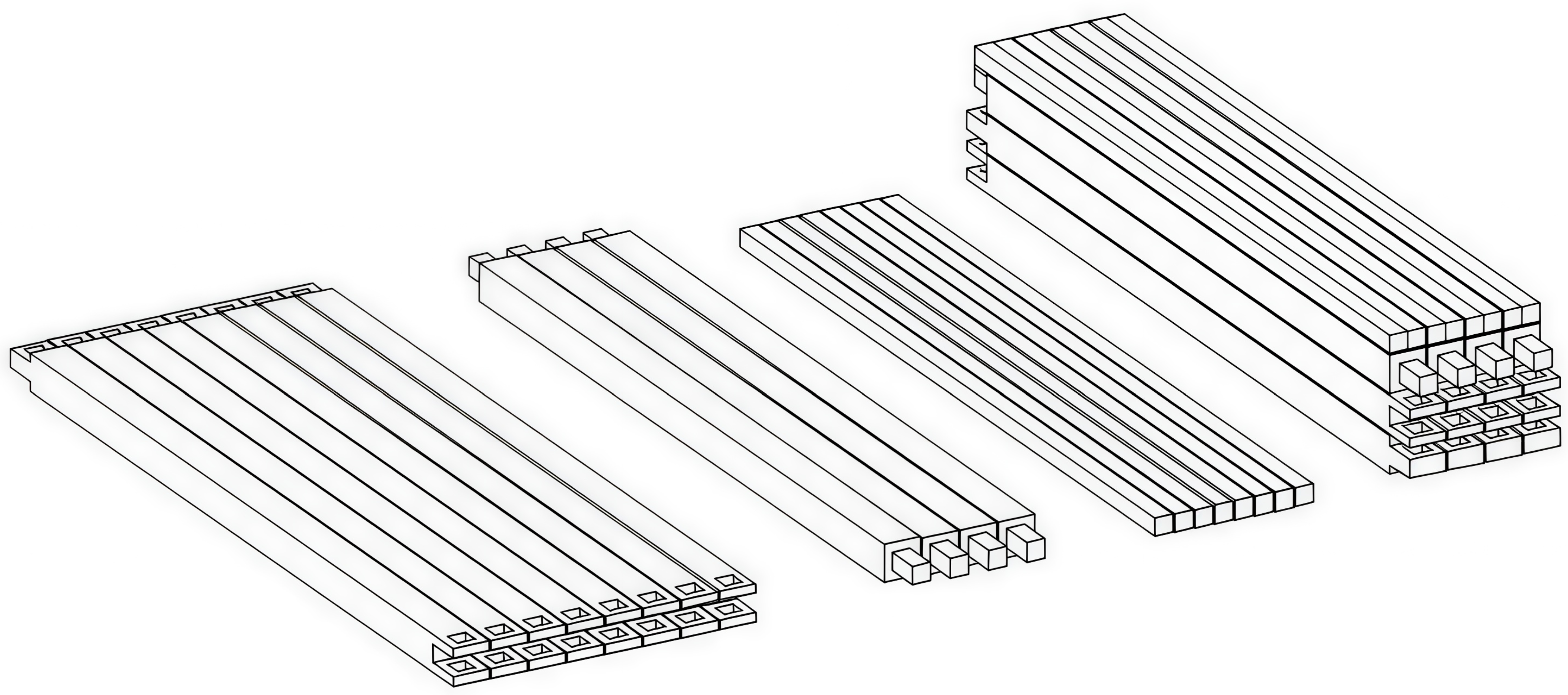
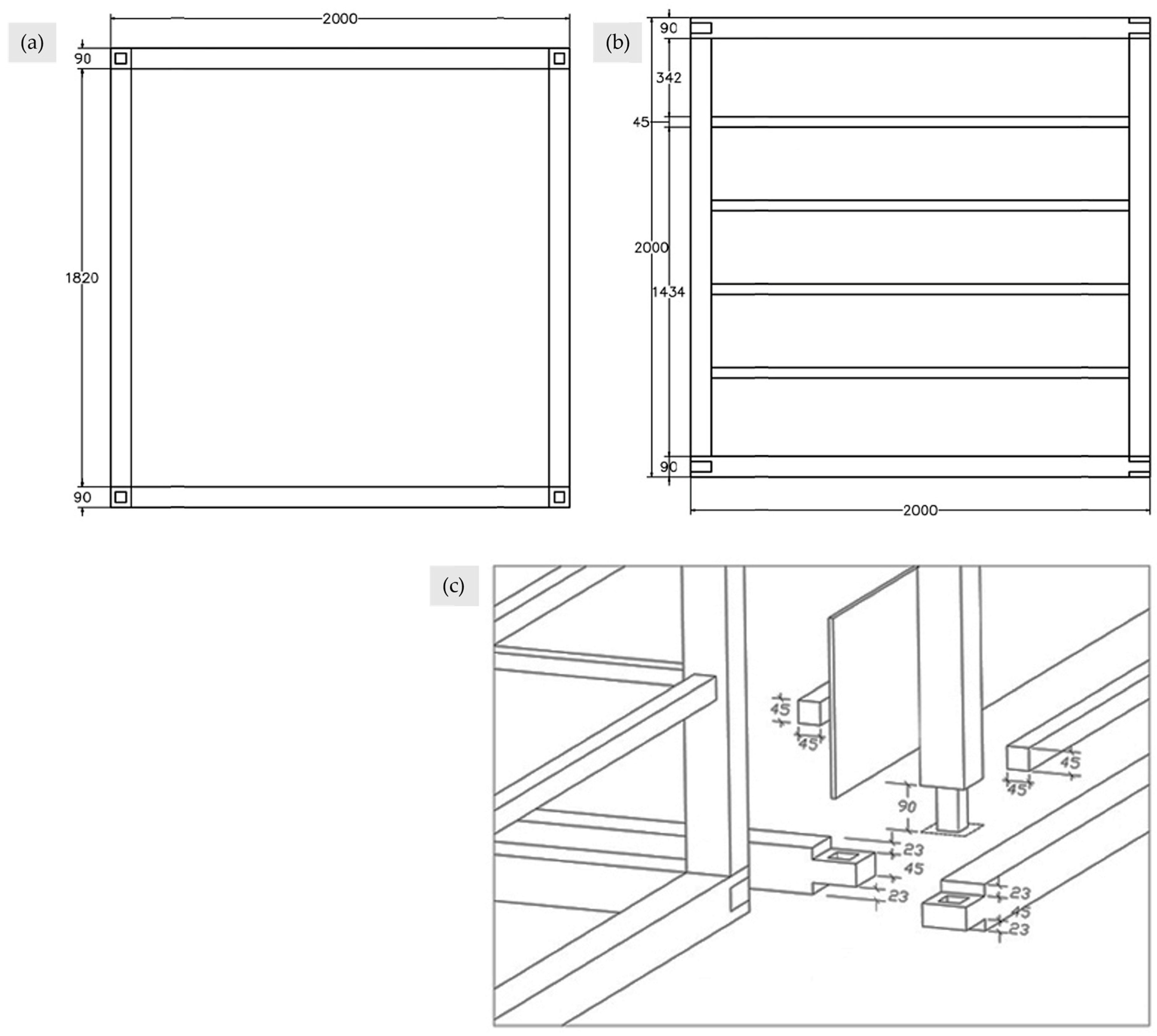
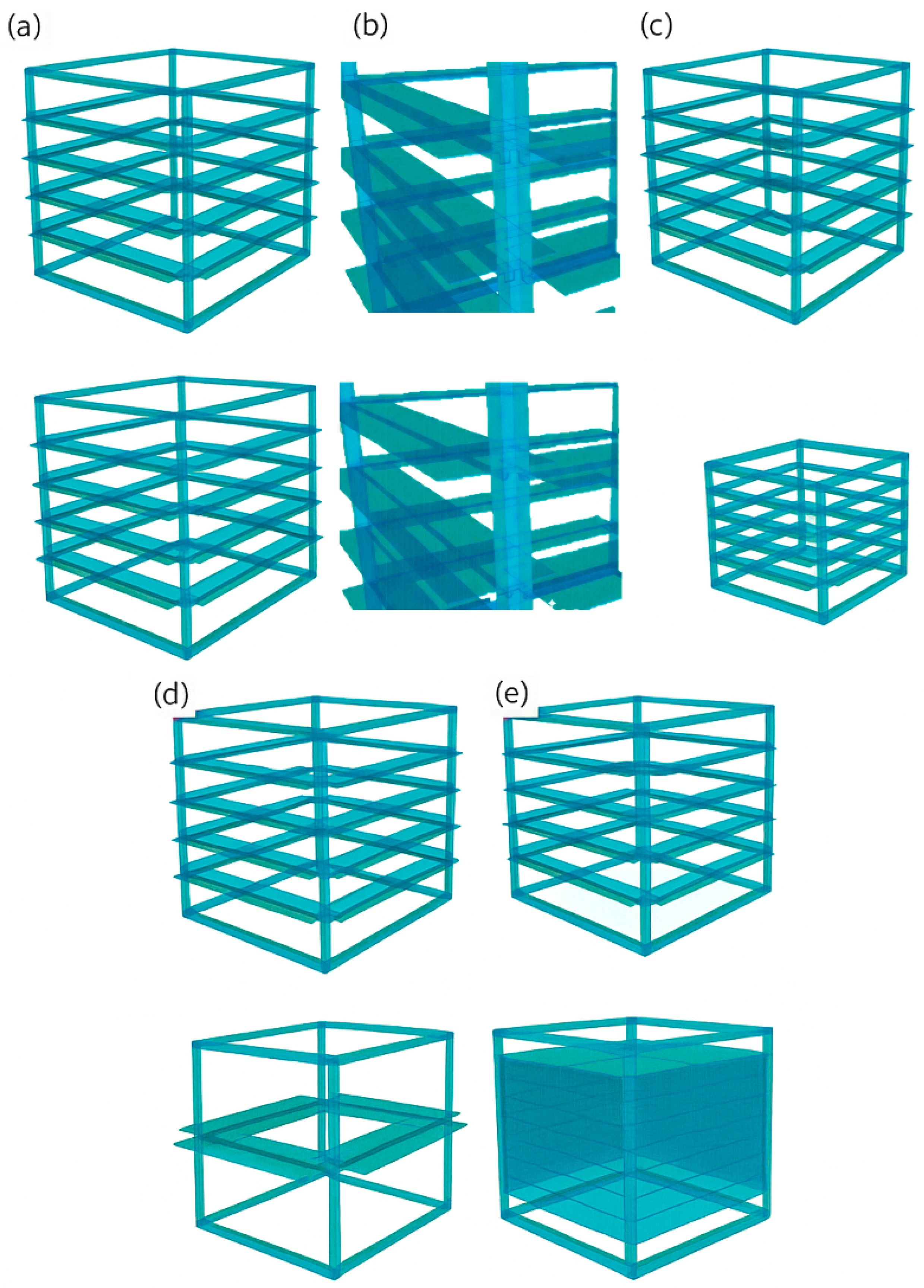
Each module included a basic kit of structural components—8 beams, 4 pillars, 8 wooden bars (45 × 45 cm), 4 bars with panels, 2 universal connectors, and PVC banners—optimising material use and ensuring reproducibility across contexts. The wooden kit is illustrated in Figure 2, showing the complete set of bars stacked compactly for efficient transport and deployment. The cube structure could be assembled without tools or metal accessories, reinforcing values of sustainability and accessibility.
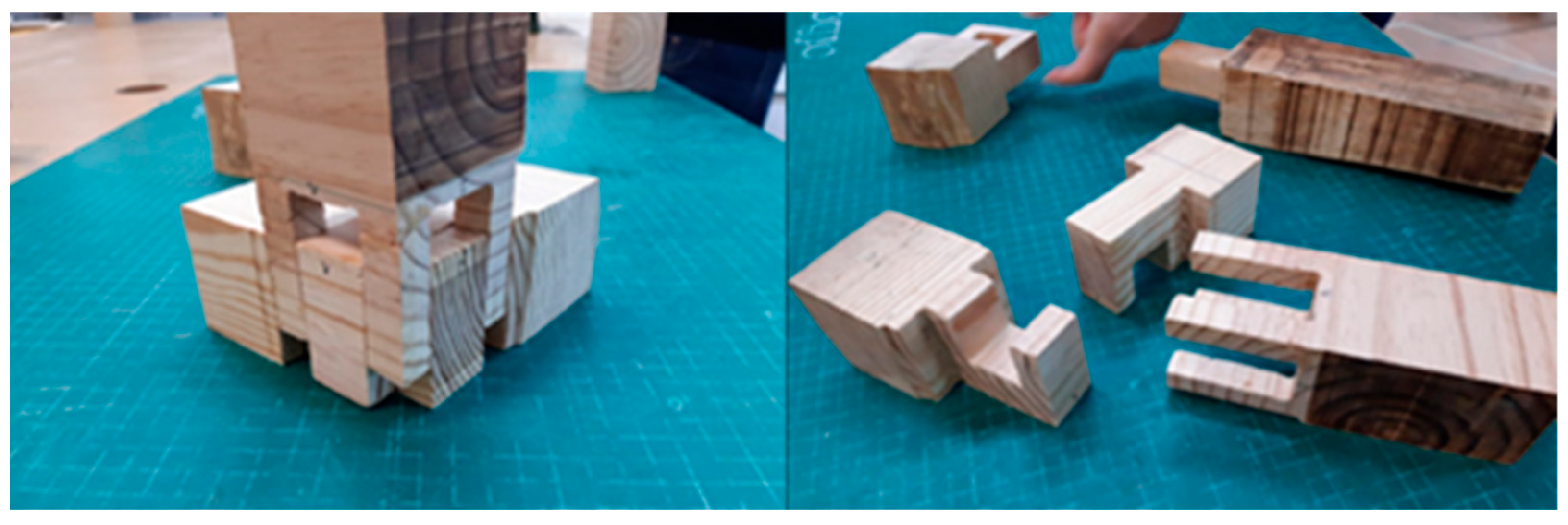
A uniform connection system was developed so that all joints could be assembled with only two bar types, ensuring rigidity in all axes. The node design, inspired by Japanese woodworking joints, enabled tool-free assembly through interlocking horizontal (XY) and vertical (ZZ) bars in a 1/3–2/3 proportion (Figure 3). Technical drawings in Figure 4 show the cube’s geometry and modular configuration. The units incorporated an Arduino-based sensor kit and Wi-Fi repeater for basic data collection [16,71]. This configuration enabled flexible use, easy replication, and digital enhancement, integrating principles of tactical urbanism (low cost, rapid deployment, reversibility [21]) with digital fabrication, allowing scalability across different educational contexts [72].
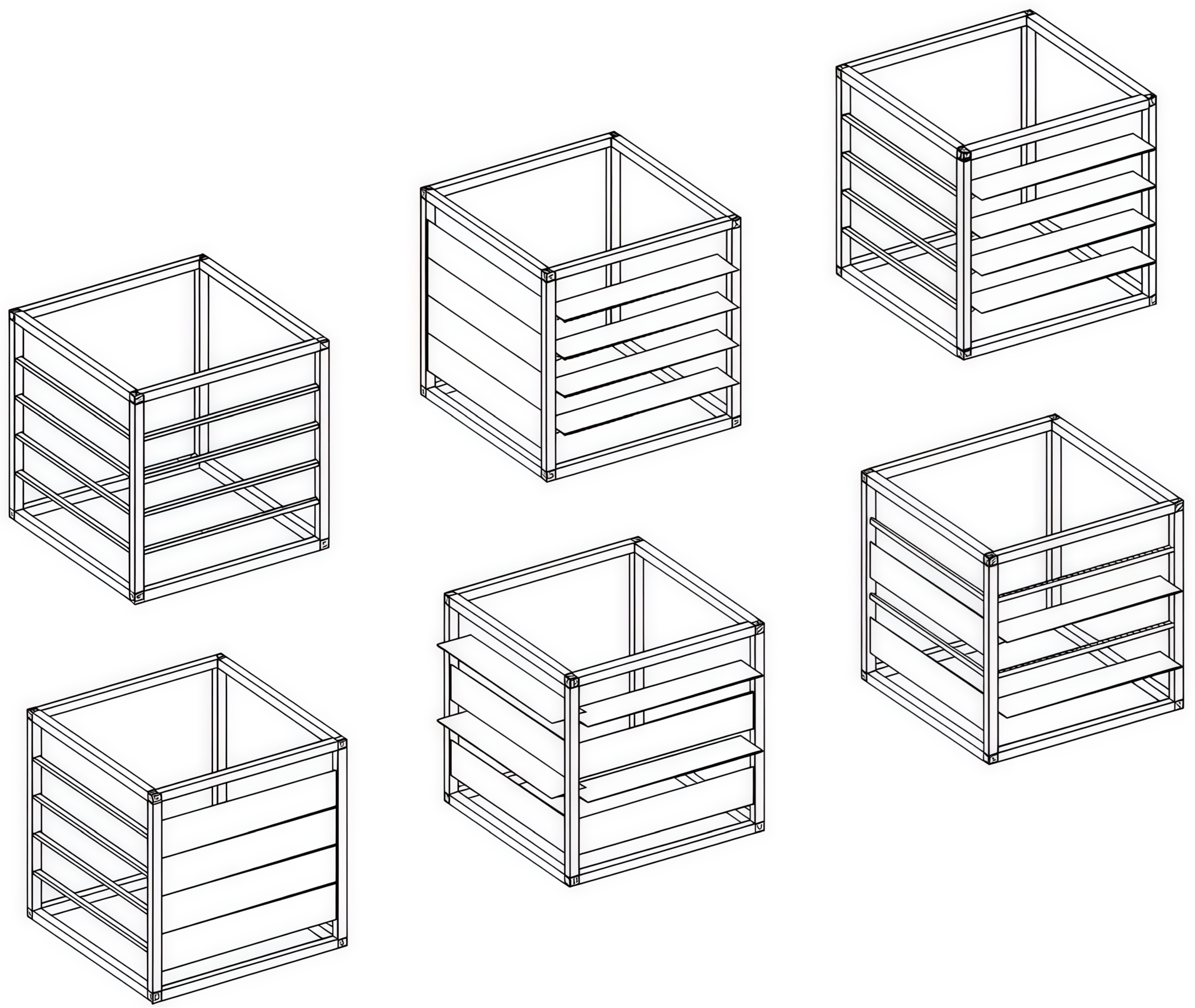
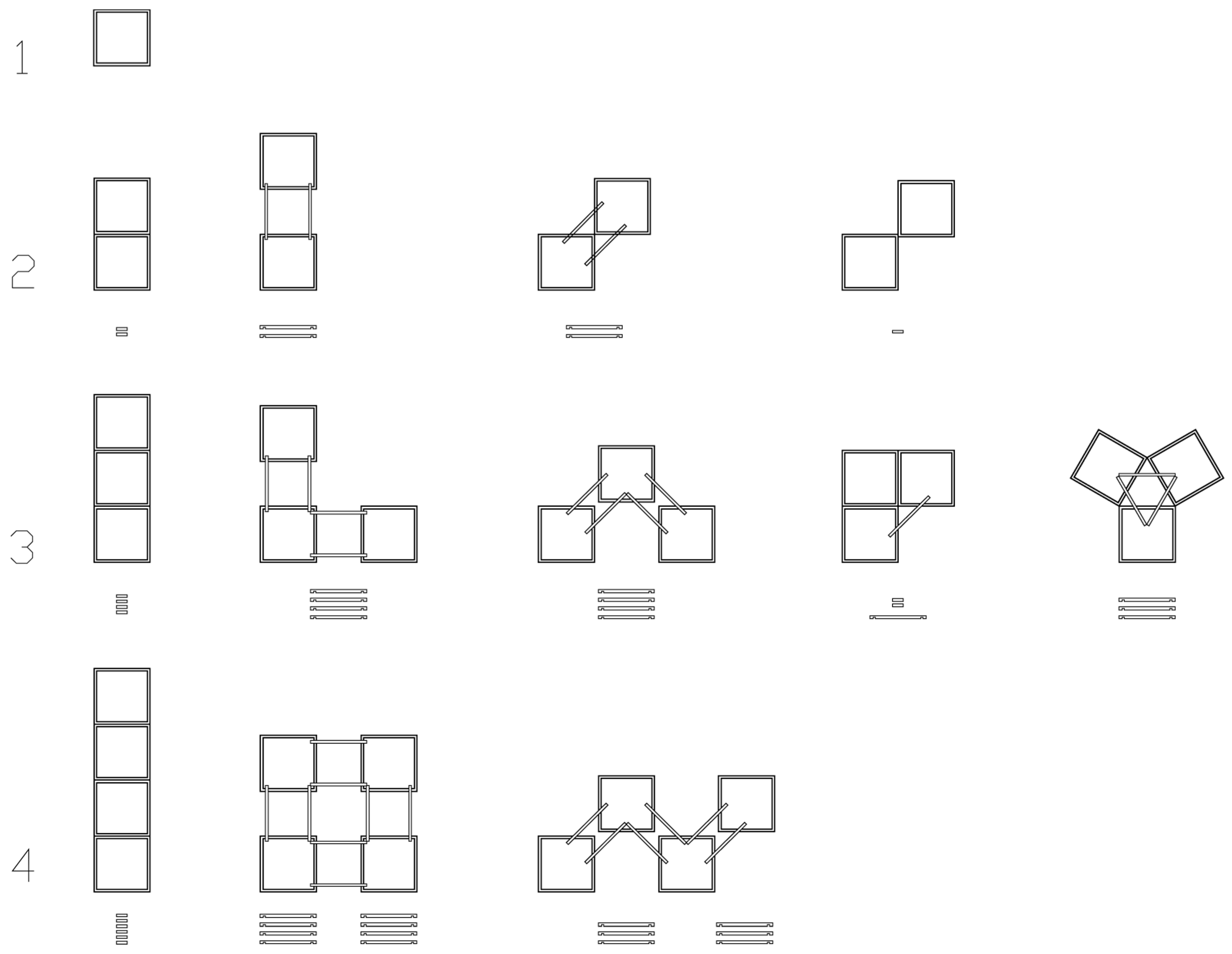
Crucially, EDUS Point was conceived as an itinerant and adaptable prototype that could be dismantled, transported, and reinstalled in different schools. Its modularity allowed multiple configurations supporting diverse uses—from outdoor classrooms and shaded seating areas to informal meeting spaces or information points. Facade variations were achieved by combining bars (B) and panels (PH/PV) in different arrangements (Figure 5). Multiple cubes could also interconnect to generate expanded or interstitial spaces (Figure 6). The objective of this project is to maximise adaptability by enabling a wide range of potential uses, such as, a beverage kiosk, magazine kiosk, information point, meeting point, health point, urban garden, display, pulpit, or temporary shelter, understood as alternative scenarios rather than simultaneous functions. Given the compact dimensions of the 200 cm cubic module, these uses are conceived to occur over time, depending on local needs and specific configurations, either through internal reconfiguration or, when required, through the aggregation of multiple cubes. Beyond its functional value, the prototype played a symbolic role as a recognisable interface between the school and its surrounding community, making the institution more porous and accessible.
To facilitate global reproducibility in FabLabs, the design was parameterized using Grasshopper, enabling adjustments to bar lengths (1.5–2.5 m), thicknesses (3–5 cm), facade divisions (1–9 elements), and panel integrations, generating STL files for CNC export—as visualized in the axonometric parametric variations (Figure 7).
Fabrication involves multi-step CNC milling for terminations (e.g., 25% thickness removal for X/Z, 50% for Y) to ensure precise fits, accounting for rounded inner corners due to milling tools. The complete kit stacks compactly for transport (four rows of XY bars and ZZ pillars at 400 × 100 mm, plus B45 bars at 400 × 50 mm), allowing solo assembly by one person over 1.75 m tall: starting with the base XY square, inserting ZZ pillars, and topping with the upper frame.
The project advanced through a collaborative process engaging multiple stakeholders: UPC researchers and students developed the design and prototyping; teachers and pupils from Institut Barri Besòs co-defined functions and uses; and parents’ associations, residents, and local makerspaces contributed through mapping activities and on-site assembly. The construction process became a pedagogical experience that linked research, community engagement, and local production. The resulting prototype and open digital files strengthened its potential for replication in other educational and urban contexts [73].
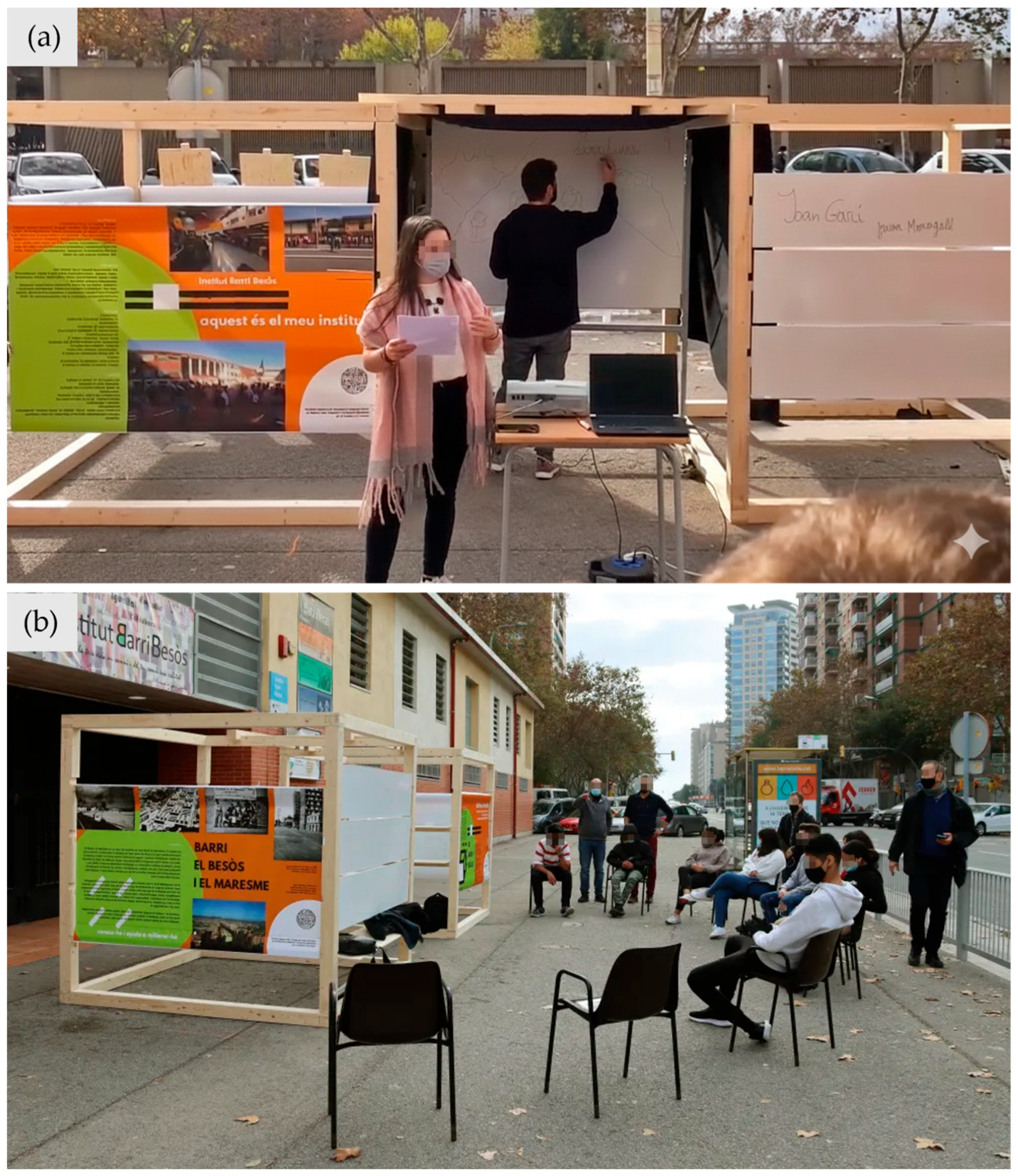
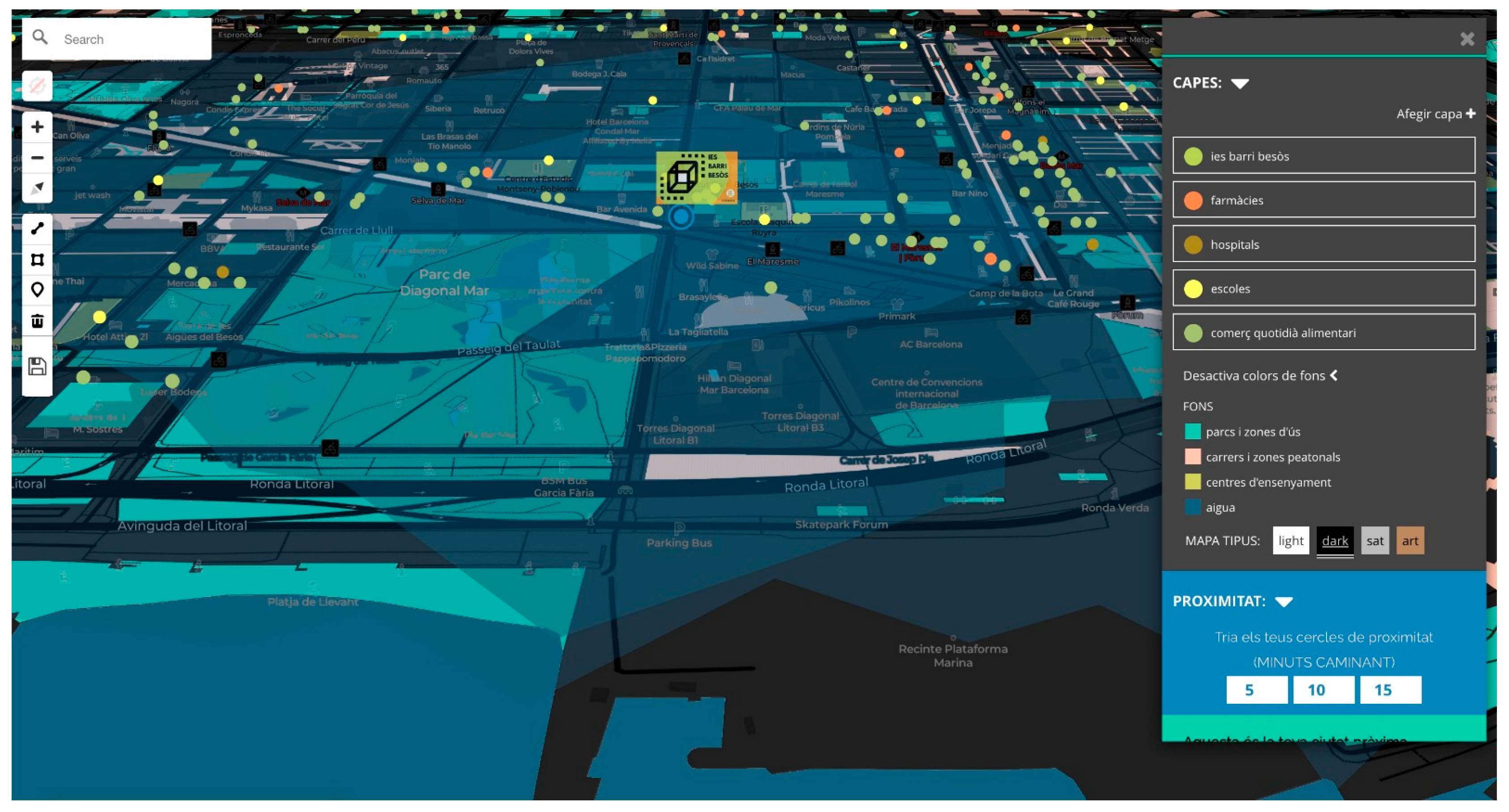
These participatory dynamics reflected the co-design principles of the FURNISH framework, materialised here through an educational and spatially adaptive prototype [17]. In addition to its physical configuration, the initiative integrated a digital layer through the Carer Cities platform—an interactive mapping tool for collective monitoring and exchange (Figure 8) [48]. At the pilot site, the prototype supported outdoor classes, projections, sensor-based data collection implemented through a Smart Citizen Kit, which enabled the real-time capture and online visualisation of basic environmental parameters (e.g., temperature, noise levels, and air quality) via Wi-Fi, and Wi-Fi connectivity, fostering participatory activities for proximity, empowerment, and neighbourhood knowledge-sharing. This hybrid character allowed EDUS Point to function simultaneously as a modular urban element, a participatory process, and a data-enabled experiment, strengthening its symbolic role as a threshold between school and neighbourhood.
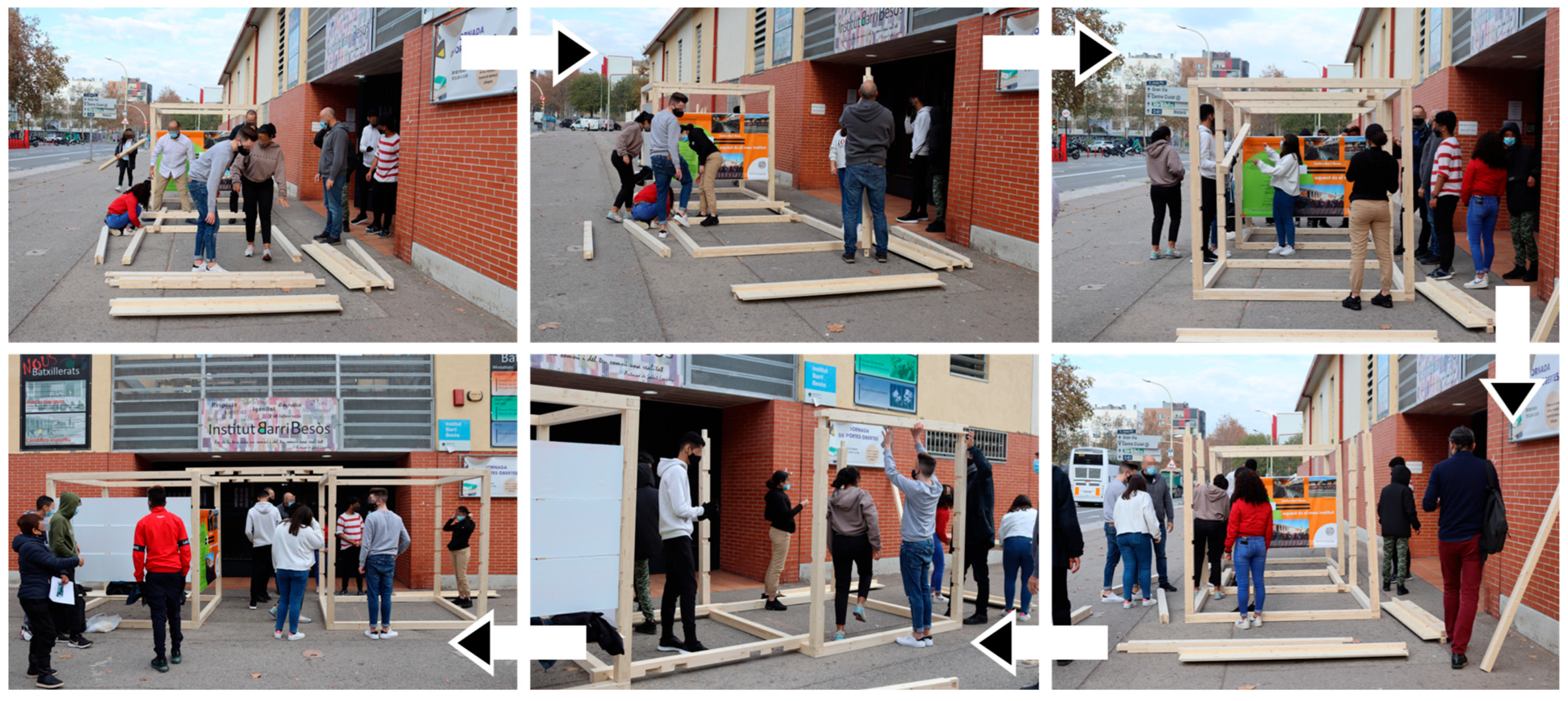
During the testing phase, EDUS Point rapidly became a focal point for the Institut Barri Besòs community and its surroundings. Students used the structure informally before and after classes, while teachers tested it for outdoor lessons and collaborative activities. Neighbours and families also engaged with the installation, transforming the street from a traffic corridor into a space of interaction, permanence, and collective appropriation. Participation was present throughout all project stages: during co-design workshops, teachers and students proposed functions and uses; during assembly (Figure 9), pupils collaborated with university participants and local makers; and once installed, neighbours and passers-by provided feedback through surveys and the Carer Cities digital platform. This process strengthened the prototype’s educational and social value as a collective learning experience.

5. Methodology

5.1. Evaluation Methods

The evaluation of the EDUS Point prototype was conducted after the completion of the four phases of the FURNISH methodology. The evaluation pursued three explicit objectives:
(i) To assess the fabrication feasibility of the prototype as a replicable and adaptable design solution;
(ii) To measure its social impact in terms of use, interaction, and perceived safety; and
(iii) To analyse its spatial impact on mobility patterns, accessibility, and street habitability.
These objectives were operationalised through a predefined set of indicators, methods, and units of observation, established prior to data collection, derived from the FURNISH evaluation framework and partially adapted to the specific local context of the EDUS Point installation in Barcelona. This approach ensured methodological transparency and enabled comparison with other FURNISH pilot prototypes.

5.1.1. Fabrication Feasibility Impact

Fabrication feasibility was assessed through a structured survey addressed to 4 makers directly involved in the fabrication and assembly of the EDUS Point prototype (members of the UPC design team and local makerspaces). Indicators included legibility of digital fabrication files, ease of assembly, availability of materials, clarity of instructions, potential for customisation, environmental considerations, climatic resistance, adaptability to new physical contexts, scalability, transportability, and storage.
Responses were collected using a standardised Google Form distributed across participating teams, complemented by fabrication logs and assembly documentation. These additional materials documented the fabrication sequence, tools, and assembly steps, allowing the survey responses to be triangulated with evidence from the making process.

5.1.2. Social Impact

Social impact was analysed using two complementary instruments.
First, structured observation forms were completed before and during installation, covering three time slots (morning, midday, afternoon) Observations were conducted across two consecutive days corresponding to the pre-installation baseline and the installation phase. Baseline observations were carried out on 19/11, and during-installation observations on 20/11, using identical time windows (12:00–13:00, 14:00–15:00, and 16:00–17:00) to ensure temporal comparability.
These forms registered the number and type of users, activities carried out, intensity of use, interactions, compliance with COVID-19 distancing, and mobility patterns, complemented by photographs. Observations were conducted by trained members of the research team following a shared protocol. Observation categories—passing, staying, gathering, and interacting—were defined prior to fieldwork to reduce ambiguity and ensure consistency. “Passing” referred to users crossing the space without stopping; “staying” to short pauses without interaction; “gathering” to group presence; and “interacting” to active engagement with the prototype or other users. To minimise double counting, observers worked within fixed spatial boundaries and sequential time windows.
Interaction data were aggregated per hour/day to enable comparison between baseline and during-installation conditions.
Second, a user survey with 18 respondents captured perceptions of the prototype regarding appropriateness, comfort, legibility, integration into the site, reinforcement of activities, and its role in promoting distancing and safety during COVID-19. The survey also included socio-demographic questions (age, gender, occupation, frequency of site use), providing additional insight into community responses [16].
An opportunistic sampling strategy was adopted, targeting users present in the space during the deployment period. Respondents included students, teachers, neighbours, and passers-by. Participation was voluntary and anonymous, and no personal identifying data were collected.
To enable comparison with other FURNISH prototypes, interaction data were analysed against the pre-installation baseline. The column “Social Impact (Interactions/Increase %)” refers to this measurement strategy: the first value indicates the absolute number of interactions recorded during the implementation phase (e.g., touch, gaze, or active use of the prototype, aggregated per hour/day), while the second represents the relative percentage increase compared to baseline conditions.
The percentage increase was calculated as follows (1):
P e r c e n t a g e   i n c r e a s e = ( I n t e r a c t i o n s   d u r i n g I n t e r a c t i o n s   b e f o r e ) I n t e r a c t i o n s   b e f o r e × 100
Interaction values were normalised by observation time to ensure comparability between sites and varying deployment durations.

5.1.3. Spatial Impact

Spatial impact was evaluated through analysis of the prototype’s integration into the school’s urban surroundings. Indicators included pedestrian flows, permanence versus transit, accessibility for different users (children, parents, neighbours), and changes in the perception of habitability of the street.
Additional indicators, drawn from the FURNISH spatial form, considered the physical modifications to the prototype once installed, the ecological cycle of materials, and the extent to which the intervention promoted safe distancing under COVID-19 measures. The collaborative mapping platform Carer Cities supported this evaluation by enabling stakeholders to document, geolocate, and share their experiences of the intervention in real time. The combination of field observations, participatory mapping, and spatial analysis offered a multi-scalar perspective on how the prototype influenced mobility patterns and neighbourhood life.

5.1.4. Operationalisation, Reliability, and Limitations

The evaluation dimensions were operationalised into measurable indicators prior to the evaluation phase. Table 3 systematises the relationship between independent variables, dependent variables (indicators), methods of measurement, units of observation, and data sources, clarifying how conceptual dimensions were translated into observable metrics.
Altogether, these evaluation methods operationalize the conceptual dimensions defined above, measuring the project’s performance after completing the FURNISH process. To enhance reliability, observation and survey instruments were standardised across the FURNISH project, and shared guidelines were provided to observers prior to data collection. However, inter-observer reliability was not formally quantified, and the user survey was not statistically validated, which constitutes a methodological limitation.
Further limitations include the extremely short observation and deployment period, restricted to two consecutive days (one pre-installation and one during installation), the small number of survey respondents (N = 18), and the very low baseline activity levels during the COVID-19 pandemic. These factors limit generalisability and may inflate relative percentage changes; therefore, results should be interpreted as indicative rather than representative.

6. Results

6.1. Fabrication Feasibility Impact

The fabrication impact survey was conducted among 4 makers using twelve criteria: correspondence between digital files and physical pieces, ease of assembly, material availability, legibility of instructions, level of customization, environmental considerations, long-term resilience and climatic resistance, adaptability to different conditions, assembly or scaling alternatives, ease of moving, and ease of storing, as well as open comments for qualitative feedback. The results, presented in Table 4, highlight the distribution of responses in the logistical and operational aspects of the prototype’s fabrication and deployment.
Ease of moving was rated “Yes, quite” by 100% of respondents, while ease of storing received 75% positive responses (“Yes, very much” or “Yes, quite”). Legibility of instructions and adaptability to different conditions also achieved 75% “Yes, quiet,” indicating clear documentation and a versatile design. Material availability, ease of assembly, and assembly alternatives reached 50%, reflecting moderate performance supported by accessible standard wooden sheets. Correspondence between digital files and physical pieces was rated at 50%, showing partial alignment between design and fabrication.
However, long-term resilience and capacity to adapt to adverse climatic conditions received more varied evaluations: 75% of responses rated climatic resistance as “No, not much,” indicating a significant weakness in durability under environmental stress. Customization possibilities were limited, with 100% of responses “Neither” or “No, not much.” Environmental considerations were rated “Neither” by 75% of respondents, reflecting a preliminary sustainable approach but limited implementation.

6.2. Social Impact

The social impact of EDUS Point was evaluated through structured observations carried out before and during installation, complemented by a post-intervention user survey. They took place on 19–20 November 2020, in three time slots (12:00–13:00, 14:00–15:00, and 16:00–17:00). Each time slot corresponded to one structured observation period, documenting user intensity (passing, staying, grouping, interacting), activities (number of participants and types), mobility, participant demographics (children < 15 years, youth 15–24 years, adults > 25 years), and qualitative descriptions.
The survey involved 18 participants, 61% female, with 72% aged 15–18, and evaluated attractiveness, ease of use, suitability for public space, general liking, comfort, COVID-19 safety, and preference for a duration longer than two weeks. Quantitative data are summarized in Table 5 and Table 6.

6.2.1. Before Intervention

Before the intervention, the site functioned predominantly as a transit space, with variable pedestrian flows and low retention, typical of an urban area under pandemic restrictions. Between 12:00–13:00, 89 people were passing, 13 stayed, 6 grouped, and 5 interacted. Activities included walking along the sidewalk (113 participants) and waiting for the bus (4 participants), with adults representing 60% (68 participants) and youth 40% (45 participants), and no children. Mobility was mainly pedestrian (103) with 4 skateboard users. Observations highlighted low retention despite some educational potential, and variable adherence to mask use and distancing, with minor non-compliance in small groupings (see Table 5).
Between 14:00–15:00, coinciding with school dismissal, the site experienced a peak of 328 passing, none staying, 5 grouping, and 7 interacting. Activities included walking (340 participants, mainly youth) and waiting for the bus (9 participants). Participants were predominantly youth (70%, 238) and adults (30%, 102), with no children. Mobility consisted of 328 pedestrians and 10 skateboard users. Observers noted a high transient youth flow, with generally good mask adherence but some distancing violations.
Between 16:00–17:00, 82 passed, none stayed, none grouped, and 3 interacted, with walking (85 participants) and waiting for the bus (8 participants). Participants were mostly adults (80%, 74) and some youth (20%, 19), with no children; mobility was fully pedestrian. Observations suggested low commercial transit, with overall adherence to COVID-19 measures.

6.2.2. During Installation

During installation, changes in user behaviour were observed, including increased retention and interaction, particularly among youth. Between 12:00–13:00, 64 people passed, 7 stayed, none grouped, and 3 interacted; activities included school entry (16 participants) and bus waiting (5 participants). Participants were 60% youth (13) and 40% adults (8), with no children; mobility included 43 pedestrians. Observation indicated low flow with minimal student curiosity but maintained COVID-19 adherence (Table 4).
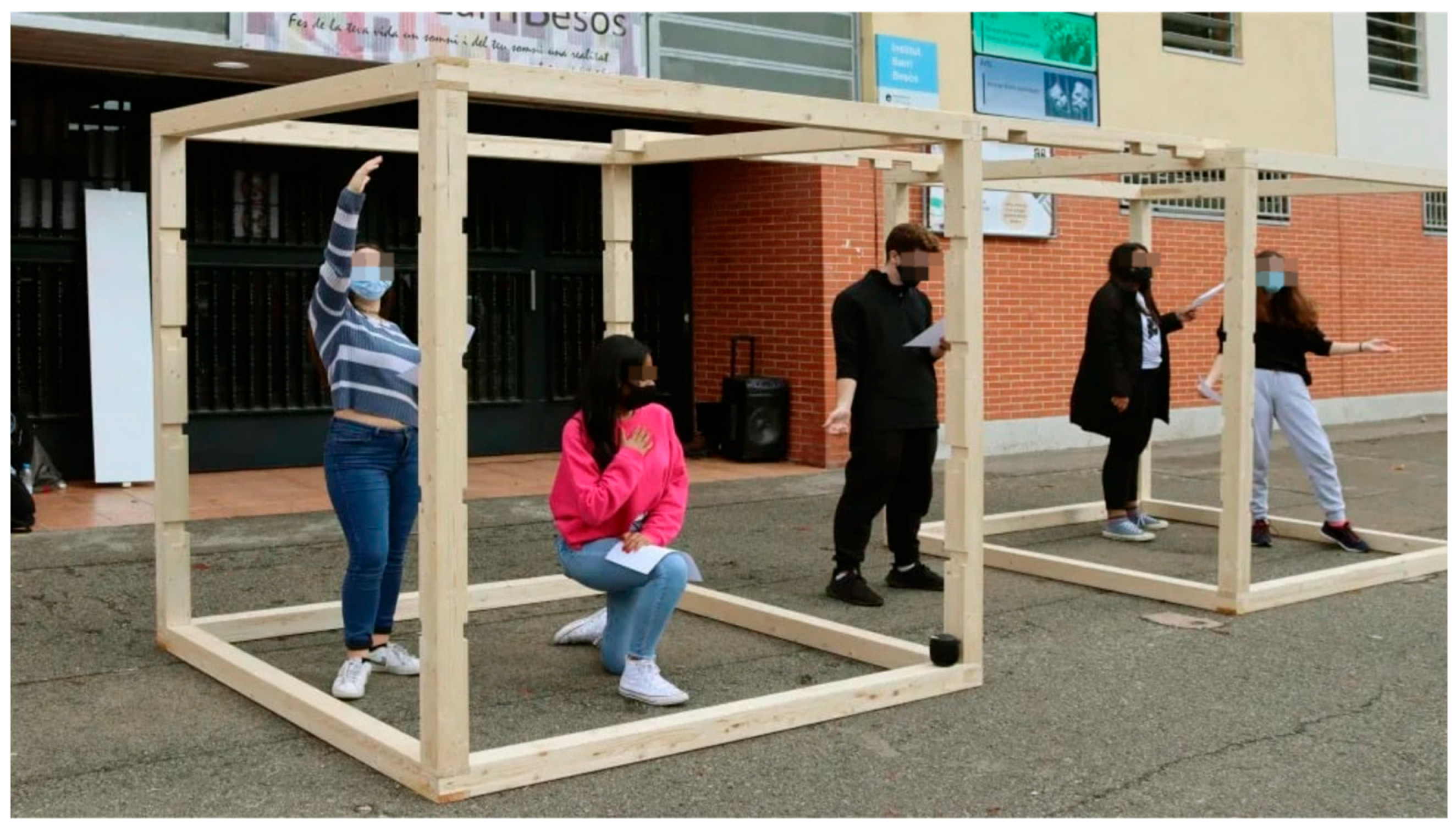
Between 14:00–15:00 (combined observations), the effect was more pronounced: 700 passing, 250 staying, 200 grouping, and 62 interacting. Activities included walking/transit (700), waiting for the bus (9), and direct interaction with the prototype (62). Participants were 65% youth (455) and 35% adults (245), no children; mobility included 685 pedestrians, 1 bicycle, 9 scooters, and 10 bus users. Observers reported a peak in youth engagement, with gaze from passing buses and physical interaction with the prototype fostering safe social dynamics. COVID-19 adherence was variable, but group management improved, and exploratory student behaviours were prominent.
Figure 10 illustrates the intensity and diversity of social use observed during this peak period, showing informal educational activities and spontaneous community interaction around the prototype.
Between 16:00–17:00, an additional observation recorded 89 users in total: 65 passing, 10 staying, none grouping, and 10 interacting. Activities included walking along the sidewalk and waiting for the bus (10 participants). Participants included 4% children (2), 22% youth (20), 52% adults (50), and 14% seniors (13). Mobility was predominantly pedestrian. Observers noted adolescents entering and exiting the school through the prototype space, with adherence to distancing and mask use maintained.

6.2.3. User Survey

The post-intervention survey assessed seven aspects: attractiveness, ease of use, suitability for public space, general liking, comfort, COVID-19 safety, and preference for a duration longer than two weeks. Results indicated that 61% (11/18) found the prototype attractive (4 “Yes, very much” and 7 “Yes, quite”), 50% (9/18; 3 “Yes, very much” and 6 “Yes, quite”) rated ease of use positively, 39% (7/18; 2 “Yes, very much” and 5 “Yes, quite”) considered it suitable for public spaces, 44% (8/18; 2 “Yes, very much” and 6 “Yes, quite”) expressed general liking, 33% (6/18; 2 “Yes, very much” and 4 “Yes, quite”) indicated comfort, 33% (6/18; 2 “Yes, very much” and 4 “Yes, quite”) reported feeling safe regarding COVID-19, and 61% (11/18; 5 “Yes, very much” and 6 “Yes, quite”) preferred the prototype to remain longer than two weeks (Table 6). Average positive responses across all items were 47%.

6.2.4. Comparative Social Impact Results Across FURNISH Prototypes

Table 7 summarises the comparison between the EDUS Point prototype and the other six prototypes of the FURNISH project, based on aggregated social impact metrics derived from structured observations conducted in five European cities (Barcelona, Guimarães, Espoo, Budapest, and Milan).
The column “Social Impact (Interactions/% Increase)” reports, first, the absolute number of interactions recorded during the deployment phase and, second, the relative percentage change compared to pre-installation baseline conditions, calculated according to Equation (1) (Section 5.1.2). Interaction values were normalised by observation time to ensure comparability across sites and deployment durations. Baseline interaction levels were particularly low across all sites due to COVID-19 mobility restrictions, with values ranging between 0 and 7 interactions per observation slot in several cases. Consequently, relative percentage values are influenced by these low initial baselines and reflect changes between observation periods based on normalised interaction counts, rather than absolute differences in long-term use intensity.
Within this framework, EDUS Point registered 62 interactions during its seven-day deployment, corresponding to a relative increase of +1240% with respect to baseline conditions. Comparable short-term increases were also observed in other FURNISH prototypes, such as VORA (+800%) and MUES:LI (+900%), despite differences in duration and spatial context. These values provide a descriptive account of short-term social activation during the implementation phase.

6.3. Spatial Impact

The spatial assessment highlighted the prototype’s contribution to improving habitability and integration in a complex urban context. The intervention redirected pedestrian flows around the school entrance, reduced congestion at peak hours, and encouraged longer permanence in the area. It also introduced a new symbolic threshold between the school and the neighbourhood, strengthening the visibility of the institution in the public realm.
As illustrated in Figure 11, EDUS Point operated as a spatial catalyst, reconfiguring everyday dynamics and perceptions of the urban environment through the activation of movement, interaction, and new spatial narratives within the public realm.
Based on systematic field observations and spatial documentation during the installation period, ten recurring spatial effects were identified and grouped according to their functional role in space use and organisation (Table 8). These effects were defined inductively by clustering observable and repeatable spatial behaviours related to movement, permanence, interaction, and environmental performance, rather than being predetermined analytical categories. These included the generation of shade to mitigate solar exposure; the delimitation of safe zones for controlled groups; orientation and attraction that modified pedestrian routes and retained 250 people in the area; virtual connectivity through WiFi and web mapping; environmental sensorisation for real-time monitoring; the display of information through panels; the dissemination of educational programmes; access to electric power; multimedia interaction via integrated devices; and support for outdoor classes and events. All spatial effects were documented during the active installation period through direct observation and photographic records.
Responses to COVID-19 conditions were articulated through four implemented features (Table 9). Natural ventilation was achieved by operating as an outdoor classroom; safe distancing was facilitated by modular delimitations organising controlled groups; flexible organisation enabled adaptations according to specific needs; and diverse layouts offered multiple setups to maximise space use.
Qualitative observations documented how the prototype redefined the immediate environment: it transformed a traffic-dominated sidewalk into a multifunctional node of social life, enabling intergenerational interactions between students, parents, and residents. It reinforced the idea of the school as a community hub, aligning with Barcelona’s tactical urbanism strategies.
The ecological cycle of the prototype was qualitatively assessed using twelve sustainability-related dimensions observed during fabrication and deployment, including efficiency in resource use, reusability of components, disassembly for recycling, modularity for adaptability, adaptability to diverse contexts, material longevity, repairability in case of damage, potential for remanufacture, recyclability of elements, equity in spatial access, community influence, and dematerialisation to reduce environmental impact. This assessment was exploratory and descriptive rather than quantitative. The installation was documented, capturing its integration with existing pavements and the variety of spatial layouts during its active period.
The ecological balance was positively evaluated due to the use of recyclable materials and an itinerant design that allowed for disassembly and reinstallation in other schools. Limitations were observed in terms of robustness and maintenance, as weather exposure and intensive use could reduce its lifespan.
Overall, the spatial impact analysis confirmed that EDUS Point acted as a temporary catalyst for rethinking school–public space relations, enhancing habitability, sustainability, and community interaction.

7. Discussion

7.1. Results Analysis

The evaluation of the EDUS Point provides empirical observations of its performance under specific deployment conditions, aligning with methodological frameworks such as the LOOP Scheme proposed for ULL in experimental projects [17].
Fabrication feasibility showed strong logistical performance in terms of fabrication, transport, and deployment, combined with clearly identified material limitations. Modular design received 100% positive ratings for transportability and 75% for storage and instruction clarity (Table 4), facilitating deployment in dynamic urban contexts. However, no positive ratings were obtained for weather resistance and customization, revealing vulnerabilities associated with the use of untreated wood materials, a pattern observed in tactical prototypes prioritising rapid implementation over durability [21]. This quantitative dichotomy underscores a trade-off between agility and robustness, suggesting that future iterations could incorporate waterproof coatings or customisable modules to mitigate environmental risks, potentially raising the current 75% adaptability rating through controlled testing in variable conditions.
Social impact, measured via pre- and post-installation observations, demonstrates a marked transformation in spatial behaviour. Prior to installation, the site exhibited transient patterns with variable pedestrian flows (maximum 328 between 14:00–15:00) and minimal stay time (0 remaining at peak), consistent with pandemic restrictions limiting social interaction (Table 5) [75]. During implementation, engagement metrics increased substantially (from 5 to 62 interactions and from 0 to 250 staying) quantifying EDUS Point’s role as an attraction node, fostering controlled gatherings (200) that balanced proximity with distancing. A survey of 18 users, predominantly youth (72% aged 15–18), corroborates this dynamic, with 61% perceiving attractiveness and 50% ease of use (Table 6), though mixed responses in comfort (33% positive) and COVID-19 safety (33%) indicate ergonomic gaps, potentially exacerbated by weather exposure. In addition, 61% of respondents expressed a desire for temporal extension of the installation. Overall, the results indicate a pronounced increase in observed interactions and staying activities relative to baseline conditions, which should be interpreted in light of the very low pre-installation activity levels and the short duration of the intervention (Table 7).
Spatial impact is evidenced through documented interventions—shade provision and space delimitation (Table 8)—which reconfigured Carrer de Josep Pla into a hybrid ecosystem, extending the school area by 4 m2 per module and enabling natural ventilation (Table 9). Environmental sensors generated real-time data for web-based mapping, captured in 20 images illustrating flexible spatial distributions, aligning with ULL metrics measuring spatial appropriation [9].
Ecological cycle considerations encompassed twelve sustainability features (e.g., modularity, recyclability), situating EDUS Point within a circular continuum. Nevertheless, the ephemeral deployment (7 days) limited longevity testing, with only 25% positive environmental ratings (Table 4).
Across observation periods, the site evolved from predominantly transit-oriented use toward more diverse patterns of staying and interaction, including youth, adults, and, during later observations, children and seniors, alongside varied mobility modes (Table 5).
Taken together, structured observations and survey responses document increased interactive use of the space during peak hours, particularly among youth, supporting informal learning, social interaction, and outdoor occupation, while also revealing limitations related to comfort, safety perception, and duration of use.

7.2. Contribution to Inclusion, Resilience, Livability, and Sustainable Mobility

EDUS Point advances inclusion, resilience, livability, and sustainable mobility, contributing to the European Green Deal through tactical interventions that democratize urban design [76]. Its participatory approach amplified youth voices (72% survey), aligning with co-creation principles in ULLs that reduce spatial inequalities [77]. The 61% desire for permanence reflects a perceived value of continued access and appropriation, particularly for marginalized educational communities in peripheral districts such as Barri Besòs, where school dropout rates exceed 15% [78].
Resilience is evidenced in pandemic adaptation: modular delimitations and outdoor ventilation (Table 9) enabled the displacement of selected educational and social activities to outdoor settings, preparing environments for future shocks such as heatwaves or recurring pandemics [79]. With 75% adaptability in fabrication (Table 4), the prototype exemplifies a form of design-oriented adaptability, a key concept in post-COVID European frameworks [80], although its long-term resilience performance could not be assessed due to the short deployment period.
For livability, the increase in stay (250 vs. 0) and outdoor educational activities improved experiential quality, aligning with Lefebvre’s [81] “right to the city” and metrics of social interaction as reflected in higher observed levels of interaction relative to baseline conditions. Environmental sensorisation contributed to the documentation of spatial conditions and usage patterns, supporting the creation of more comfortable and responsive outdoor environments [3], though no direct measurements of well-being were conducted within this study.
In sustainable mobility, the intervention encouraged pedestrianization (685 pedestrians during installation) and micromobility (9 scooters), expanding non-motorized spaces by 4 m2 and minimizing emissions via local FabLab fabrication [82], supporting the EU Urban Mobility Framework [83]. While no direct emissions data were collected, local fabrication and short-distance logistics suggest a reduced environmental footprint compared to conventional construction processes.

7.3. Comparative Discussion Within the FURNISH Prototype Family

The EDUS Point prototype can be meaningfully contextualised within the broader European FURNISH project, which developed seven tactical urbanism interventions in 2020 across five cities. Each prototype responded to specific urban challenges with varying emphases, from cultural activation to community play, while EDUS Point uniquely foregrounded educational engagement and digital integration.
Rather than reintroducing the general characteristics of the FURNISH programme, which are described in Section 3.3, this section builds on the empirical findings to discuss how EDUS Point compares with the other prototypes in terms of strengths, limitations, and potential for transfer. This comparative discussion is grounded in observed use patterns, documented constraints, and design features emerging from the pilot deployment.
A deeper understanding of user engagement, strengths, limitations, and replicability is provided in Table 10. This table illustrates the key strengths, observed constraints, and replicability potential of each prototype, allowing a nuanced discussion of what sets EDUS Point apart. In particular, while prototypes such as AEIOU or THEA-TRON are context-specific and culturally focused, EDUS Point demonstrates strong potential for school-centred public space strategies, although weather resilience and ergonomic comfort remain critical limitations.
Taken together, the comparison suggests that EDUS Point’s main contribution within the FURNISH family lies in the coupling of educational use with modular and digitally instrumented urban furniture, while sharing with other prototypes the structural limitations typical of short-term tactical interventions. This balance between specificity and common constraints provides the basis for the following discussion on limitations and replicability.

7.4. Limitations

The EDUS Point prototype also revealed several limitations:
  • Material durability: plywood and PVC banners were low-cost and reproducible but not resilient to weather or intensive use.
  • Comfort: only 33% of survey respondents rated the prototype as comfortable, reflecting limitations in ergonomics and protection against climate exposure.
  • COVID-19 safety: although distancing and modular delimitations were enabled, only one-third of users perceived it as fully safe, highlighting the difficulty of addressing subjective safety perceptions during a transitional post-pandemic period.
  • Temporal character: as with many tactical urbanism interventions, EDUS Point risked being perceived as ephemeral, with limited capacity to produce long-term transformations unless institutionalised [21].
  • Dependency on context and collaboration: the success relied on Institut Barri Besòs, local administration, and makerspaces. In contexts with weaker governance or fewer fabrication infrastructures, replication could be more difficult.
  • Environmental considerations: fabrication feasibility surveys highlighted limited integration of life-cycle thinking, with only partial attention to recycling or circularity.
  • Post-pandemic usage conditions: the prototype was tested during a period of exceptional demand for outdoor public space. As restrictions have been lifted and indoor activities restored, the intensity and type of use observed during deployment may not be directly replicable under normal conditions, limiting the generalisability of the results beyond the pandemic context.

7.5. Potential for Replicability

Despite its limitations, EDUS Point demonstrates strong potential for replication and contextual adaptation, both within Europe and beyond. Its modular and digitally fabricated structure, combined with its social and pedagogical logic, allows for flexible reconfiguration across diverse urban scenarios.
In Europe, the prototype can easily be adapted to contexts where municipalities promote school protection and pedestrianisation (e.g., Paris’ Rues aux Écoles, Amsterdam’s “school streets”). The open-source digital fabrication files enable low-cost reproduction, and the modular design facilitates adaptation to multiple geometries and scales. With the growing institutional support for tactical urbanism and child-friendly cities, EDUS Point provides a model for temporary yet transformative interventions that strengthen community ties through spatial experimentation [17,53].
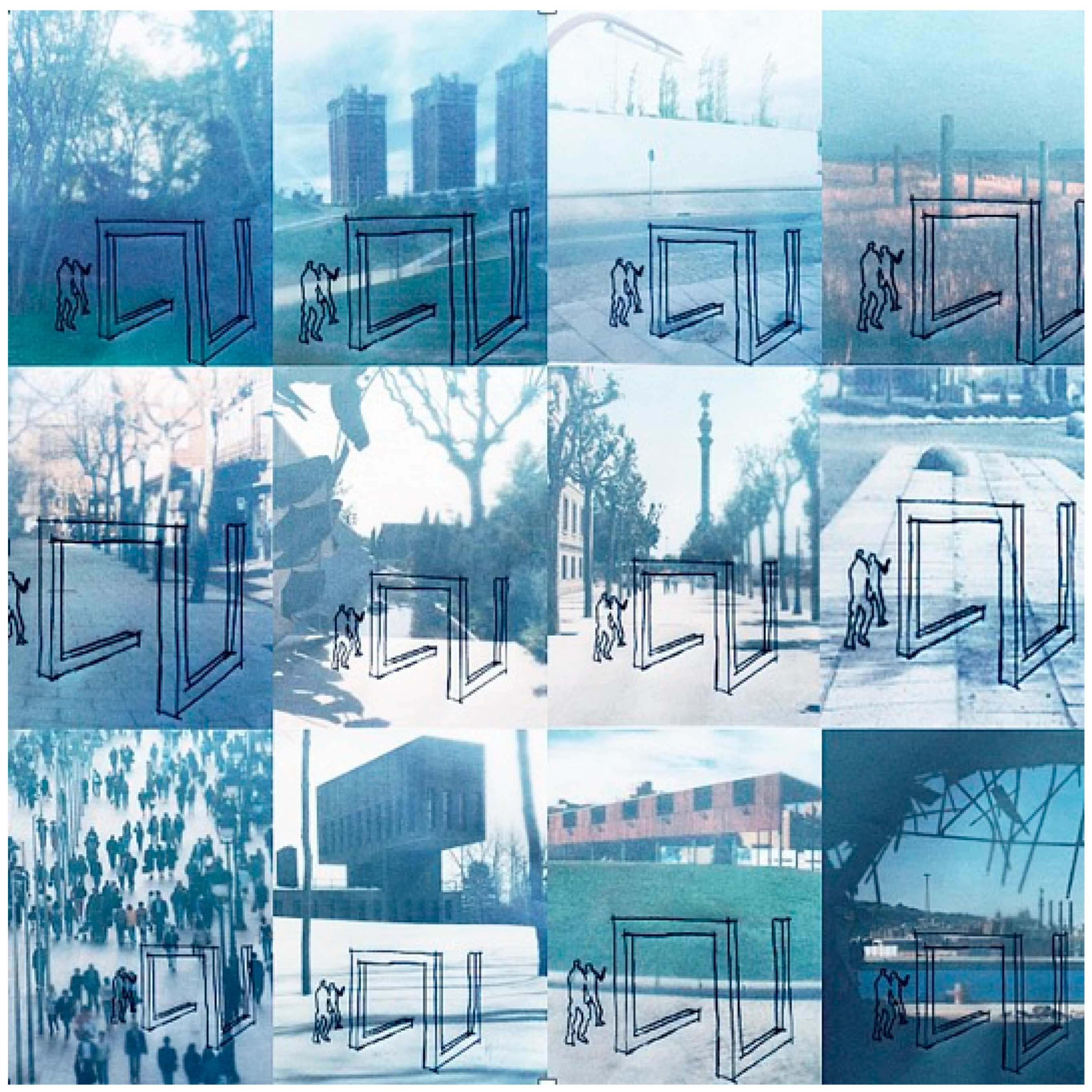
However, the adaptability of EDUS Point extends well beyond educational environments. Its flexible structure, lightweight materials, and open modular logic make it equally suitable for a variety of public contexts requiring rapid spatial reconfiguration or civic activation. As illustrated in Figure 12, the prototype can be reimagined within neighbourhood squares, pedestrian pathways, coastal promenades, and green areas such as parks or community gardens. In these settings, EDUS Point can function as a mobile and temporary infrastructure, hosting workshops, cultural events, informal learning sessions, or moments of rest and dialogue. This versatility transforms the prototype into a civic artefact capable of mediating between formal and informal uses, adapting to both compact urban fabrics and open natural landscapes.
In the Global South, replication would require context-sensitive adaptation:
  • Materials: substituting plywood with locally available, climate-resilient options such as bamboo, recycled plastic, or compressed earth panels, to increase durability under tropical or humid climates.
  • Technical feasibility: simplifying fabrication to suit contexts with limited CNC infrastructure, possibly through hybrid manual and semi-digital processes in local workshops.
  • Governance: reinforcing collaboration with community organisations, NGOs, cooperatives, or schools, especially where municipal technical capacity is limited or decentralised.
These adaptations would extend the life cycle of the prototype and strengthen local economies through distributed manufacturing, circular design practices, and co-production networks, consistent with the principles of design for social innovation [73].
The educational and civic layers remain central to its transferability. Unlike prototypes oriented solely toward leisure or aesthetic enhancement, EDUS Point integrates pedagogical, environmental, and participatory dimensions, encouraging users to engage in co-design, fabrication, and evaluation. This participatory approach enhances local ownership and social learning, ensuring that replication processes activate empowerment and shared stewardship rather than simple physical reproduction [84].
As argued by Manzini [73], such socially embedded design strategies are powerful not because of the object itself, but because of the processes and networks they activate. In this sense, EDUS Point exemplifies a new generation of tactical urban devices capable of transcending disciplinary boundaries between education, culture, and civic participation. Its capacity to transform ordinary urban and natural spaces—such as school entrances, plazas, waterfronts, and green corridors—into inclusive, adaptive, and collectively governed environments supports both European and Global South agendas for resilient, equitable, and human-centred urban transitions.

7.6. Lessons Learned and Practical Implications

This study provides promising evidence, under specific pilot and pandemic-related conditions, of the capacity of a school-based ULL to activate public space through a temporary educational artefact. Beyond the case-specific results, several transferable lessons emerge.
First, for municipalities, the EDUS Point demonstrates the usefulness of tactical and reversible interventions as testing devices at the school–street interface, allowing patterns of interaction, stay, and mobility to be observed before committing to permanent transformations. However, the findings also indicate that short-term activation effects should not be directly extrapolated to post-pandemic or long-term conditions without further longitudinal testing.
Second, for schools and educational communities, the prototype shows the potential of temporary outdoor extensions to support informal learning and social interaction. At the same time, the low comfort and weather-resilience ratings (Table 4) underline that usability beyond exceptional contexts depends on improved ergonomic design and climatic protection.
Third, from a design and fabrication perspective, the results highlight the importance of clearly distinguishing between experimental demonstrators and long-term urban infrastructures. While modularity and ease of deployment were positively evaluated, material durability and life-cycle considerations remain critical challenges to be addressed in future iterations.
Finally, from a research perspective, the paper contributes a tri-dimensional evaluation framework (fabrication feasibility, social impact, and spatial impact) that enables a structured assessment of school-based ULLs and their comparative positioning within a family of prototypes such as FURNISH. This approach supports cautious interpretation of percentage-based indicators and reinforces the need to combine quantitative observations with qualitative field notes when evaluating short-term, context-dependent urban experiments.

8. Conclusions

The evaluation of the EDUS Point prototype provides promising empirical evidence of tactical urban interventions to support educational, social, and spatial dynamics in public spaces, particularly under conditions of restricted mobility such as the COVID-19 pandemic. Its modular design, combined with sensor-based monitoring, enabled rapid deployment and flexible adaptation within the specific pilot context, offering an exploratory reference for short-term urban innovation.
Comparative analysis with other FURNISH prototypes suggests EDUS Point’s distinctive contribution. Its integration of digital data collection with educational activities enables targeted engagement, particularly among youth, and provides quantifiable insights for iterative design. The prototype recorded a noticeable short-term increase in interactions and spatial use compared to baseline conditions, though limitations in weather resistance and ergonomic comfort underscore the need for material refinement and inclusive design. Notably, innovation was embedded holistically within the pilot through the convergence of the urban context, digital device construction, online platform, and educational and community programmes, reinforcing EDUS Point’s dual character as both a spatial artefact and a social process that bridges physical and digital layers of urban experimentation.
EDUS Point’s replicability potential appears promising due to its open-source modular structure, low-cost fabrication, and adaptability to diverse urban environments. The intervention’s focus on educational and social activation, combined with observed engagement outcomes, indicates its relevance for school-centred public space strategies and temporary urban interventions in both European and Global South contexts, provided that contextual, material, and post-pandemic usage conditions are carefully considered.
Overall, the study reinforces the value of integrating educational, social, and technological dimensions in tactical urbanism, while recognising the exploratory nature of short-term ULL deployments. Future research should explore longitudinal deployment, multi-site comparisons, and the incorporation of adaptive materials and inclusive design elements to enhance resilience, usability, and scalability. Such efforts will contribute to evidence-based urban design that fosters learning, community participation, and sustainable use of public spaces.

Author Contributions

F.E.B.A.: Conceptualization, methodology, formal analysis, investigation, data curation, writing—original draft preparation, visualization, writing—review and editing. J.S.S.C.: Investigation, writing—original draft preparation, visualization, writing—review and editing. J.G.G.: writing—review and editing, funding acquisition. I.R.C.: Investigation, writing—review and editing, supervision, funding acquisition. M.Y.M.C.: Conceptualization, methodology, formal analysis, investigation, data curation, writing—original draft preparation, writing—review and editing. All authors have read and agreed to the published version of the manuscript.

Funding

The Furnish project was partially funded under the COVID 2021 call (KAVA 20237) by EIT Urban Mobility, an initiative of the European Institute of Innovation and Technology (EIT). The funding entity code is EIT-UM-2020-2029.

Institutional Review Board Statement

Not applicable.

Informed Consent Statement

Not applicable.

Data Availability Statement

The data presented in this study are available from the corresponding authors upon request, due to privacy restrictions.

Acknowledgments

We would like to acknowledge the contribution of all the other members of the Edus Point team: Josep Bordonau, Xavier Ferrer, Xavier Costa, Patricia Paniagua, Jorge Rodríguez, Cristina Poza, Mikel Casado, Miquel Estrada, Francesco Caradonna, Israel Arias, María Olaya and Marta Gamiz.

Conflicts of Interest

The authors declare no conflicts of interest. The funders had no role in the design of the study; in the collection, analyses, or interpretation of data; in the writing of the manuscript, or in the decision to publish the results.

References

  1. Gehl, J. Cities for People; Island Press: Washington, DC, USA, 2010. [Google Scholar]
  2. Carmona, M. Principles for public space design, planning to do better. Urban Des. Int. 2019, 24, 47–59. [Google Scholar] [CrossRef]
  3. Honey-Rosés, J.; Anguelovski, I.; Chireh, V.K.; Daher, C.; Konijnendijk van den Bosch, C.; Litt, J.S.; Mawani, V.; McCall, M.K.; Orellana, A.; Oscilowicz, E.; et al. The impact of COVID-19 on public space: An early review of the emerging questions—Design, perceptions and inequities. Cities Health 2020, 5, 263–279. [Google Scholar] [CrossRef]
  4. Anguelovski, I.; Connolly, J.J.T.; Masip, L.; Pearsall, H. Assessing green gentrification in historically disenfranchised neighborhoods: A longitudinal and spatial analysis of Barcelona. Urban Geogr. 2018, 39, 458–491. [Google Scholar] [CrossRef]
  5. Noszczyk, T.; Gorzelany, J.; Kukulska-Kozieł, A.; Hernik, J. The impact of the COVID-19 pandemic on the importance of urban green spaces to the public. Land Use Policy 2022, 113, 105925. [Google Scholar] [CrossRef] [PubMed]
  6. Bovo Peres, R.; Fanan Peres, T.; Noés Patracon, L.; Gonçalves Mello, J.; dos Santos Pereira, R.C. Public open spaces during the COVID-19 Pandemic: Perceptions regarding usage, behaviors, and advancements in urban policies. Rev. Gestão Ambient. Sustentabilidade (GeAS) 2024, 13, 1–31. [Google Scholar] [CrossRef]
  7. UN-Habitat. UN-Habitat Guidance on COVID-19 and Public Space; UN-Habitat: Nairobi, Kenya, 2020; Available online: https://unhabitat.org/sites/default/files/2020/06/un-habitat_guidance_on_covid-19_and_public_space.pdf (accessed on 12 November 2025).
  8. Voytenko, Y.; McCormick, K.; Evans, J.; Schliwa, G. Urban living labs for sustainability and low carbon cities in Europe: Towards a research agenda. J. Clean. Prod. 2016, 123, 45–54. [Google Scholar] [CrossRef]
  9. Steen, K.; van Bueren, E. The Defining Characteristics of Urban Living Labs. Technol. Innov. Manag. Rev. 2017, 7, 21–33. [Google Scholar] [CrossRef]
  10. Chawla, L.; Keena, K.; Pevec, I.; Stanley, E. Green schoolyards as havens from stress and resources for resilience in childhood and adolescence. Health Place 2014, 28, 1–13. [Google Scholar] [CrossRef]
  11. Ghaziani, R. Children’s voices: Raised issues for school design. CoDesign 2008, 4, 225–236. [Google Scholar] [CrossRef]
  12. Watson, K.; Newman, L. Children’s voices: Inclusive early childhood placemaking with children. J. Early Child. Res. 2024, 22, 258–271. [Google Scholar] [CrossRef]
  13. Moreno, C.; Allam, Z.; Chabaud, D.; Gall, C.; Pratlong, F. Introducing the “15-minute city”: Sustainability, resilience and place identity in future post-pandemic cities. Smart Cities 2021, 4, 93–111. [Google Scholar] [CrossRef]
  14. Cordero-Vinueza, V.A.; Van Dijk, T.; Lamker, C.; Niekerk, F. Making child-friendly cities: A quest for local agenda-setting. Cities 2025, 161, 105882. [Google Scholar] [CrossRef]
  15. Bernet, A.; Hinder, N.; Theus, S.; Junghanns, N. Planning and Designing Child-Friendly Living Spaces. Basel. 2020. Available online: https://www.unicef.ch/sites/default/files/2021-10/Handbuch_EN.pdf (accessed on 20 September 2025).
  16. Aquilué Junyent, I.; Caicedo Mafla, M.A.; Casorrán, S.; Ferorelli, R.; Guallart, V.; Ibáñez, D.; Moreno Sanz, J.; Ojeda, M.; Paez, R.; Pagès, L. FURNISH: New Methodologies to Intervene in Public Space; Iniciativa Digital Politècnica (IDP): Barcelona, Spain, 2023. [Google Scholar]
  17. Aquilué, I.; Caicedo, A.; Moreno, J.; Estrada, M.; Pagès, L. A methodology for assessing the impact of living labs on urban design: The case of the furnish project. Sustainability 2021, 13, 4562. [Google Scholar] [CrossRef]
  18. Mayorga Cárdenas, M.Y.; Galindo González, J.; Rodríguez Cantalapiedra, I.; Bordonau, J.; Estrada, M.; Ferrer Masip, X.; Arias Reyna, I.; Olaya, M.C.; Caradonna, F.; Gamiz Sánchez, M.; et al. EDUS Point/Punt EDUS—Educational Expanded Dispositive for Urban Space & Community and Healthy Networking Relationship. 2020. Available online: https://eduspointupc.wordpress.com/ (accessed on 15 October 2025).
  19. Tschumi, B. Architecture and Disjunction, 1st ed.; MIT Press: Cambridge, MA, USA, 1994. [Google Scholar]
  20. Wigley, M. The Architecture of Deconstruction: Derrida’s Haunt, 5th ed.; MIT Press: Cambridge, MA, USA, 1997. [Google Scholar]
  21. Lydon, M.; Garcia, A. Tactical Urbanism: Short-Term Action for Long-Term Change; Island Press: Washington, DC, USA, 2015. [Google Scholar]
  22. Silva, P. Tactical urbanism: Towards an evolutionary cities’ approach? Environ. Plan. B Urban Anal. City Sci. 2016, 43, 1040–1051. [Google Scholar] [CrossRef]
  23. Finn, D. DIY urbanism: Implications for cities. J. Urban. Int. Res. Placemaking Urban Sustain. 2014, 7, 381–398. [Google Scholar] [CrossRef]
  24. Tonkiss, F. Austerity urbanism and the makeshift city. City 2013, 17, 312–324. [Google Scholar] [CrossRef]
  25. Jacobs, J. The Death and Life of Great American Cities; Random House: New York, NY, USA, 1961. [Google Scholar]
  26. Lerner, J. Urban Acupuncture; Island Press: Washington, DC, USA, 2016. [Google Scholar]
  27. Gustafson, D. A Just Post-Pandemic City: Examining Spatial Change in the Form of the 15-Minute City and Its Capability to Address Social Inequalities in Stockholm, Sweden. Master’s Thesis, KTH Royal Institute of Technology, Stockholm, Sweden, 2022. [Google Scholar]
  28. Mayorga Cárdenas, M.Y.; Fontana, M.P. ¿Dónde Acaba la Escuela y Empieza la Ciudad? The Conversation, 24 February 2021. Available online: https://theconversation.com/donde-acaba-la-escuela-y-empieza-la-ciudad-140279 (accessed on 20 September 2025).
  29. Appleyard, D. Livable Streets, 1st ed.; University of California Press: Oakland, CA, USA, 1981. [Google Scholar]
  30. Ewing, R.; Dumbaugh, E. The Built Environment and Traffic Safety: A Review of Empirical Evidence. J. Plan. Lit. 2009, 23, 347–367. [Google Scholar] [CrossRef]
  31. Mitra, R.; Buliung, R.N. Built environment correlates of active school transportation: Neighborhood and the modifiable areal unit problem. J. Transp. Geogr. 2012, 20, 51–61. [Google Scholar] [CrossRef]
  32. Skelton, T.; Valentine, G. (Eds.) Cool Places: Geographies of Youth Cultures, 1st ed.; Routledge: London, UK, 1998. [Google Scholar]
  33. Lieberg, M. Teenagers and Public Space. Commun. Res. 1995, 22, 720–744. [Google Scholar] [CrossRef]
  34. Chawla, L.; Heft, H. Children’s competence and the ecology of communities: A functional approach to the evaluation of participation. J. Environ. Psychol. 2002, 22, 201–216. [Google Scholar] [CrossRef]
  35. Dyment, J.E.; Bell, A.C. ‘Our garden is colour blind, inclusive and warm’: Reflections on green school grounds and social inclusion. Int. J. Incl. Educ. 2008, 12, 169–183. [Google Scholar] [CrossRef]
  36. Blair, D. The Child in the Garden: An Evaluative Review of the Benefits of School Gardening. J. Environ. Educ. 2009, 40, 15–38. [Google Scholar] [CrossRef]
  37. Woolner, P. (Ed.) School Design Together, 1st ed.; Routledge: London, UK, 2014. [Google Scholar]
  38. Bulkeley, H.; Coenen, L.; Frantzeskaki, N.; Hartmann, C.; Kronsell, A.; Mai, L.; Marvin, S.; McCormick, K.; van Steenbergen, F.; Voytenko Palgan, Y. Urban living labs: Governing urban sustainability transitions. Curr. Opin. Environ. Sustain. 2016, 22, 13–17. [Google Scholar] [CrossRef]
  39. Björgvinsson, E.; Ehn, P.; Hillgren, P.-A. Agonistic participatory design: Working with marginalised social movements. CoDesign 2012, 8, 127–144. [Google Scholar] [CrossRef]
  40. Sanders, E.B.-N.; Stappers, P.J. Co-creation and the new landscapes of design. CoDesign 2008, 4, 5–18. [Google Scholar] [CrossRef]
  41. Huybrechts, L. (Ed.) Participation Is Risky: Approaches to Joint Creative Processes; Valiz/Antennae Series: Amsterdam, The Netherlands, 2014. [Google Scholar]
  42. Batty, M. Digital twins. Environ. Plan. B Urban Anal. City Sci. 2018, 45, 817–820. [Google Scholar] [CrossRef]
  43. De Los Santos Melo, A.; Beriguete Alcántara, F.E. Maximizing Learning Potential: Embracing the Power of Digital Twins in Architectural and Construction Education of the Twenty-first Century. In Teaching Innovation in Architecture and Building Engineering; Bienvenido-Huertas, A.J., de la Hoz-Torres, D., Aguilar Aguilera, M.L., Eds.; Springer: Berlin/Heidelberg, Germany, 2024; pp. 477–493. [Google Scholar]
  44. Berigüete, F.E.; Santos, J.S.; Rodriguez Cantalapiedra, I. Digital Revolution: Emerging Technologies for Enhancing Citizen Engagement in Urban and Environmental Management. Land 2024, 13, 1921. [Google Scholar] [CrossRef]
  45. Cardullo, P.; Kitchin, R. Being a ‘citizen’ in the smart city: Up and down the scaffold of smart citizen participation in Dublin, Ireland. GeoJournal 2019, 84, 1–13. [Google Scholar] [CrossRef]
  46. Goodchild, M.F. Citizens as sensors: The world of volunteered geography. GeoJournal 2007, 69, 211–221. [Google Scholar] [CrossRef]
  47. Haklay, M. Citizen Science and Volunteered Geographic Information: Overview and Typology of Participation. In Crowdsourcing Geographic Knowledge; Sui, D., Elwood, S., Goodchild, M., Eds.; Springer: Dordrecht, The Netherlands, 2012; pp. 105–122. [Google Scholar]
  48. City Field of View. Carer Cities. Available online: https://carercities.com/ (accessed on 10 October 2025).
  49. Heeks, R.; Renken, J. Data justice for development: What would it mean? Inf. Dev. 2016, 34, 90–102. [Google Scholar] [CrossRef]
  50. Solà-Morales, I. Territorios; Editorial Gustavo Gili, SA: Barcelona, Spain, 2003. [Google Scholar]
  51. St Hill, C. This Is Temporary: How Transient Projects Are Redefining Architecture, 1st ed.; RIBA Publishing: London, UK, 2019. [Google Scholar]
  52. Hou, J. (Ed.) Insurgent Public Space: Guerrilla Urbanism and the Remaking of Contemporary Cities, 1st ed.; Routledge: London, UK, 2010. [Google Scholar]
  53. Lydon, M.; Garcia, A. A Tactical Urbanism How-To. In Tactical Urbanism: Short-Term Action for Long-Term Change; Island Press/Center for Resource Economics: Washington, DC, USA, 2015; pp. 171–208. [Google Scholar]
  54. Karandinou, A. No Matter: Theories and Practices of the Ephemeral in Architecture, 1st ed.; Routledge: London, UK, 2017. [Google Scholar]
  55. Scravaglieri, P.M. Liquid Architecture: Experimental Practices of Design in a State of Flux, 1st ed.; Routledge: London, UK, 2023. [Google Scholar]
  56. Karandinou, A. (Ed.) Data, Architecture and the Experience of Place, 1st ed.; Routledge: London, UK, 2018. [Google Scholar]
  57. Gerència de l’Arquitecte/a en Cap; Gerència d’Àrea d’Ecologia Urbana; Barcelona Regional Agència de Desenvolupament Urbà, S.A. Superilla Barcelona: Barcelona 2015–2023; Direcció de Serveis Editorials: Barcelona, Spain, 2023; Available online: https://ajuntament.barcelona.cat/ecologiaurbana/ca/qui-som/arees/arquitecte-en-cap (accessed on 12 October 2025).
  58. Agència Energia de Barcelona. Pla d’energia, Canvi Climàtic i Qualitat de l’aire de Barcelona 2011–2020 (PECQ); Agència Energia de Barcelona: Barcelona, Spain, 2021; Available online: https://ajuntament.barcelona.cat/ecologiaurbana/sites/default/files/PlaEnergia_CanviClimatic_QualitatAire-2011-2020.pdf (accessed on 20 September 2025).
  59. Ajuntament de Barcelona. Compromiso Ciudadano por la Sostenibilidad 2012–2022; Ajuntament de Barcelona: Barcelona, Spain, 2012; Available online: https://ajuntament.barcelona.cat/ecologiaurbana/sites/default/files/CompromisoCiudadanoSostenibilidad.pdf (accessed on 3 October 2025).
  60. Gerència d’Àrea d’Ecologia Urbana; Gerència de Mobilitat i Infraestructures. Pla de Mobilitat Urbana 2024; Ajuntament de Barcelona: Barcelona, Spain, 2022; Available online: http://hdl.handle.net/11703/128157 (accessed on 1 October 2025).
  61. Ajuntament de Barcelona. Plan del Verde y de la Biodiversidad 2012–2020; Ajuntament de Barcelona: Barcelona, Spain, 2012; Available online: https://ajuntament.barcelona.cat/ecologiaurbana/es/que-hacemos-y-porque/ciudad-verde-y-biodiversidad/plan-verde-y-la-biodiversidad (accessed on 3 October 2025).
  62. Ajuntament de Barcelona. Caminos Escolares del Distrito. Available online: https://ajuntament.barcelona.cat/santmarti/es/el-ayuntamiento/estrategia-y-accion-de-gobierno/planes-y-proyectos/caminos-escolares-del-distrito (accessed on 1 October 2025).
  63. Ajuntament de Barcelona. Protegemos las Escuelas. 2023. Available online: https://ajuntament.barcelona.cat/ecologiaurbana/es/que-hacemos-y-porque/urbanismo-para-los-barrios/protegemos-escuelas (accessed on 20 September 2025).
  64. Agència de Salut Pública de Barcelona. Avaluació del Programa Protegim les Escoles; Agència de Salut Pública de Barcelona: Barcelona, Spain, 2023; Available online: https://www.aspb.cat/wp-content/uploads/2023/03/Avaluacio-programa-Protegim-Escoles.pdf (accessed on 9 October 2025).
  65. Ajuntament de Barcelona. Refugios Climáticos en las Escuelas. 2020. Available online: https://www.barcelona.cat/barcelona-pel-clima/es/escuelas-refugios-climaticos (accessed on 20 September 2025).
  66. Ajuntament de Barcelona. Transformamos los Patios. 2024. Available online: https://ajuntament.barcelona.cat/educacio/es/transformamos-los-patios (accessed on 1 October 2025).
  67. Consorci d’Educació de Barcelona. Pla Clima Escola Barcelona; Consorci d’Educació de Barcelona: Barcelona, Spain, 2023; Available online: https://www.edubcn.cat/rcs_gene/extra/00_transparencia/Govern_i_organitzacio/acords_CD_2023_10_18/03_CD_181023_pla_clima_escola.pdf (accessed on 14 October 2025).
  68. Departament d’Educació. Nous Aprenentatges, Nous Espaiss: Guia per als Projectes de Construcció i Transformació de Centres Educatius Públics; Departament d’Educació: Barcelona, Spain, 2022; Available online: https://educacio.gencat.cat/web/.content/home/departament/publicacions/monografies/construccions-escolars/nous-aprenentatges-nous-espais/nous-aprenentatges-nous-espais.pdf (accessed on 1 October 2025).
  69. Boettger, T. Threshold Spaces: Transitions in Architecture. Analysis and Design Tools, 1st ed.; Birkhäuser Verlag GmbH: Berlin, Germany, 2014. [Google Scholar]
  70. Laboratori de Maquetes (LabMaq) ETSAB UPC. Proyecto FURNISH. 2020. Available online: https://utgab.upc.edu/ca/laboratori-de-maquetes-labmaq/labmaq-maker-es/proyecto-furnish (accessed on 8 October 2025).
  71. Paniagua Abreu, P. Hacia una Ciudad Proactiva, Urbanismo Táctico y Nuevas Tecnologías para Participación Ciudadana en la Ciudad de Barcelona. Master’s Thesis, Universitat Politècnica de Catalunya, Barcelona, Spain, 2021. [Google Scholar]
  72. Gershenfeld, N. How to Make Almost Anything: The Digital Fabrication Revolution. Foreign Aff. 2012, 91, 43–57. Available online: https://www.jstor.org/stable/41720933 (accessed on 8 October 2025).
  73. Manzini, E. Design, When Everybody Designs: An Introduction to Design for Social Innovation; The MIT Press: Cambridge, MA, USA, 2015. [Google Scholar]
  74. City Field of View. Carer Cities IES Barri Besòs. 2020. Available online: https://carercities.com/u/ies-barri-besos# (accessed on 10 October 2025).
  75. Florida, R.; Rodríguez-Pose, A.; Storper, M. Critical Commentary: Cities in a post-COVID world. Urban Stud. 2023, 60, 1509–1531. [Google Scholar] [CrossRef]
  76. Fetting, C. The European Green Deal. Vienna. 2020. Available online: https://eur-lex.europa.eu/legal-content/EN/TXT/PDF/?uri=CELEX:52019DC0640&from=EN (accessed on 12 October 2025).
  77. Menny, M.; Voytenko Palgan, Y.; McCormick, K. Urban living labs and the role of users in co-creation. GAIA-Ecol. Perspect. Sci. Soc. 2018, 27, 68–77. [Google Scholar] [CrossRef]
  78. UN-Habitat. World City Report 2022. Envisaging the Future of Cities; UN-Habitat: Nairobi, Kenya, 2022; Available online: https://unhabitat.org/sites/default/files/2022/06/wcr_2022.pdf (accessed on 3 October 2025).
  79. Meerow, S.; Newell, J.P.; Stults, M. Defining urban resilience: A review. Landsc. Urban Plan. 2016, 147, 38–49. [Google Scholar] [CrossRef]
  80. Bassot, É.; Debié, F.; de Finance, S.; Nogaj, M.; Worum, A. Towards a More Resilient Europe Post-Coronavirus:Capabilities and Gaps in the EU’s Capacity to Address Structural Risks; European Parliament: Brussels, Belgium, 2020. [Google Scholar] [CrossRef]
  81. Lefebvre, H. Le Droit à la Ville, 3rd ed.; Economica: Vienna, Austria, 2009. [Google Scholar]
  82. Valenzuela-Zubiaur, M.; Bustos, H.T.; Arroyo-Vázquez, M.; Ferrer-Gisbert, P. Promotion of social innovation through Fab Labs. The case of ProteinLab UTEM in Chile. Sustainability 2021, 13, 8790. [Google Scholar] [CrossRef]
  83. European Commission. Sustainable & Smart Mobility Strategy: Putting European Transport on Track for the Future. 2020. Available online: https://eur-lex.europa.eu/legal-content/EN/TXT/?uri=CELEX%3A52020DC0789 (accessed on 3 October 2025).
  84. Bjögvinsson, E.; Ehn, P.; Hillgren, P.A. Design things and design thinking: Contemporary participatory design challenges. Des. Issues 2012, 28, 101–116. [Google Scholar] [CrossRef]
Figure 1. Four-phase design and implementation framework adopted within the FURNISH project, illustrating the iterative workflow from problem identification and ideation to assessment within the ULL approach. Adapted from Aquilué et al. [17].
Land 15 00150 g001
Figure 2. Kit Components. Stacked arrangement of XY bars, ZZ pillars, and B45 bars for compact transport [70].
Land 15 00150 g002
Figure 3. Node design of the EDUS Point cube. Illustration of the modular node system enabling assembly without metal fasteners [70].
Land 15 00150 g003
Figure 4. EDUS Point Cube Geometry. (a) Plan view, (b) Elevation, and (c) Axonometric view of the modular cube structure, illustrating its spatial configuration, proportions, and potential for multiple assembly arrangements [70].
Land 15 00150 g004
Figure 5. Possible combinations in the cube facades, illustrating variations using bars (B) and panels (PH/PV) for different functional uses, such as kiosks or information points [70].
Land 15 00150 g005
Figure 6. Combinations of multiple cubes, where 1 corresponds to a single cube, 2 to a configuration with two cubes, 3 to an arrangement of three cubes, and 4 to a composition of four cubes, showing interconnected modular units creating interstitial spaces or expanded areas for community interventions [70].
Land 15 00150 g006
Figure 7. Parametric variations of the EDUS Point Cube. (a) Variation of main bar thickness, (b) variation of secondary bar thickness, (c) variation of total cube length, (d) variation of the number of façade elements, and (e) variation of panel position. The static frames, extracted from the Grasshopper simulation, illustrate the parametric adaptability of the cube design for digital fabrication and contextual customization [70].
Land 15 00150 g007
Figure 8. Carer Cities platform. Project interface display showing the EDUS BESÒS proximity atlas (“15-min city”), with neighborhood health, educational, and everyday services located within a 5-, 10-, and 15-min walking distance. Colors are used to distinguish thematic layers: colored dots indicate the location of different facilities and services (e.g., health, education, and food retail), shaded areas represent parks and open spaces, darker tones indicate the street network and built-up areas, and blue gradients show walking-time proximity zones (5, 10, and 15 min). Source: Carer Cities platform, https://carercities.com/u/ies-barri-besos# (accessed on 1 January 2026) [74].
Land 15 00150 g008
Figure 9. Assembly process of the EDUS Point prototype. Arrows indicate the sequential workflow from initial components to the fully assembled prototype.
Land 15 00150 g009
Figure 10. Social interaction during peak use of the EDUS Point installation, (a) Outdoor educational activity, where facilitators and participants interact through visual materials, drawings, and informal presentations, fostering knowledge exchange and active learning in a public space; (b) Planned educational activity carried out with students from the Institut Barri Besòs as part of the project, illustrating increased retention, youth engagement, and collective appropriation of public space [18].
Land 15 00150 g010
Figure 11. The EDUS Point as a spatial catalyst that reconfigures everyday dynamics and perceptions of the urban environment, exemplifying the spatial impact through the activation of movement, interaction, and new spatial narratives within the public realm [18].
Land 15 00150 g011
Figure 12. Adaptability and potential replication of the EDUS Point prototype in diverse urban contexts. Study collage.
Land 15 00150 g012
Table 1. Evaluation dimensions and variables used in FURNISH.
DimensionMain FocusKey QuestionExample
Feasibility ImpactTechnical/economicIs the prototype feasible, sustainable, and replicable?Construction using local materials with low environmental impact and low cost.
Social ImpactCommunity-based/participatoryDoes it generate social cohesion and participation?Citizen workshops on co-creation and use; activity programs based on alternating or simultaneous compatible uses.
Spatial ImpactUrban/morphologicalDoes it transform the experience and use of space?Installation that revitalizes an underutilized square or space by creating an urban setting.
Note: The evaluation dimensions and variables are derived from the standardized FURNISH assessment framework and were applied consistently across all pilot prototypes, allowing comparative analysis while accommodating local adaptations [17].
Table 2. Positioning of the EDUS Point within the FURNISH family of prototypes.
PrototypeCity/CountryConcept/ObjectiveTarget UsersMain ActorsSpatial ContextType of Intervention
AEIOUGuimarães, PortugalSensory urban device to explore sound and distanceGeneral publicDesigners, citizensOpen urban spacesInteractive installation
KONCHEspoo,
Finland
Seating element supporting dialogue and restStudents’ school/universityFabLab, studentsEducational settings (indoor/outdoor)Modular furniture
THEA-TRONBudapest, HungaryTemporary structures for cultural expressionNeighboursDesigners, neighboursCourtyardsTactical cultural installation
MUES:LIMilan, ItalyModular urban furniture systemGeneral publicDesigners, local usersPublic spacesUrban furniture
EDUS PointBarcelona, SpainTemporary architectural device supporting learning-related activitiesAdolescents (ESO & Bachillerato)UPC, Institut Barri Besòs, students, teachers, neighbours, makerspacesSchool–street interfaceEducational urban prototype
VORABarcelona, SpainSpatial device to mediate between cars and pedestriansChildren and pedestriansSchool, residents, municipalitySchool-adjacent streetsSafety-oriented intervention
Open TerraceBarcelona, SpainModular system reclaiming vehicular spacePedestriansResidents, traders, municipalityStreetsTactical street intervention
Note: Synthesised from Aquilué et al. [17].
Table 3. Dimensions, indicators, methods, and units of observation.
DimensionIndependent VariablesDependent Variables/IndicatorsMethods/InstrumentsUnit of ObservationData Sources
Feasibility impactDigital design filesLegibility of digital filesStructured survey (Google Forms)Prototype components and fabrication process4 Makers (Local makerspaces)
Material systemEase of assembly
Availability of materials
Clarity of instructions
CustomisationFabrication logs
Environmental aspects
Climatic resistance
Assembly logicAdaptabilityAssembly documentation
Modularity
Transportability
Storage
Social impactPrototype presenceNumber and type of usersStructured observation forms I & II (before/during, 3 time slots, weekdays and weekends)/ Photographic recordsUsers per hour/day; individual survey responsesEnd users and citizens (students, teachers, neighbours, passers-by)
18 respondents
Activities and interactions
Waiting times
Compliance with COVID-19 distancing
Appropriation of space
Temporal conditions (weekday/weekend; time slots)AttractivenessUser survey
Ease of use
Suitability for public space
General liking
Comfort
COVID-19 safety
Preference for >2 weeks
Spatial impactPrototype installationPedestrian flowsFURNISH spatial formStreet segment/installation areaDesigners, citizens, student, local partner (Institut Barri Besòs) y It is not necessary, we have removed it. (Ajuntament de Barcelona)
Permanence vs. transit
Street configurationAccessibilityParticipatory mapping (Carer Cities platform)
Integration with neighbourhood
Physical modifications to prototypeSpatial analysis
Material footprintEcological cycle
COVID-19 distancing
Note: Evaluation dimensions and indicators were adapted from the FURNISH framework [17]. Actors involved correspond to the three levels defined in the project (design community, end users, and local administrations).
Table 4. Fabrication survey results.
CriteriaYes, Very MuchYes, QuiteNeitherNo, Not Much% “Yes”
Correspondence digital files022050%
Ease of assembly021150%
Material availability021150%
Legibility of instructions031075%
Customization00220%
Environmental considerations013025%
Climatic resistance/Long-term resilience00130%
Adaptability to conditions030175%
Assembly alternatives021150%
Ease of moving0400100%
Ease of storing121075%
Note: Responses were provided by four teams of designers and makers. Percentages under “% Yes” represent the proportion of respondents selecting either “Yes, very much” or “Yes, quite” for each criterion. The table reflects both strengths and limitations of the EDUS Point prototype in terms of assembly, material availability, adaptability, customization, environmental considerations, and long-term resilience under adverse conditions.
Table 5. User intensity and activity before and during installation of EDUS Point.
Time/DatePassingStayingGatheringInteractingMain Mobility
Before intervention
12:00–13:00 (19/11)891365Pedestrians (103), Skateboard (4)
14:00–15:00 (19/11)328057Pedestrians (328), Skateboard (10)
16:00–17:00 (19/11)82003Pedestrians (82), Skateboard (3)
During Installation
12:00–13:00 (20/11)64703Pedestrians (43), Others (31)
14:00–15:00 (20/11)70025020062Pedestrians (685), Bicycle (1), Scooter (9), Bus (10)
16:00–17:00 (20/11)6510010Pedestrians (dominant)
Note: Data were collected through structured observations, capturing the number of users passing, staying, grouping, and interacting. Main mobility indicates the type and number of users in motion. Observations before installation reflect transient space usage with low retention, while during installation, the prototype increased user retention and interaction, especially among youth.
Table 6. User survey results on EDUS Point post-intervention and demonstrative radar diagrams.
CriteriaYes, Very MuchYes, QuiteNeitherNo, Not MuchNo, Not At All% Yes
Attractiveness4752061%
Ease of use3663050%
Suitability for public space2564139%
General liking2673044%
Comfort2464233%
COVID-19 safety2456133%
Preference for >2 weeks5643061%
Note: Survey conducted with 18 participants (61% female; 72% aged 15–18). Responses are classified from “Yes, very much” to “No, not at all.” The percentage of “Yes” includes both “Yes, very much” and “Yes, quite” responses. Results indicate positive acceptance of the prototype in attractiveness, ease of use, and duration, but highlight areas for improvement in comfort, COVID-19 safety, and suitability for public spaces.
Table 7. Social impact and duration of FURNISH prototypes.
PrototypeSocial Impact (Interactions/% Increase)Duration (Days)
AEIOU120/+600%10
KONCH80/+500%7
THEA-TRON90/+450%10
MUES:LI200/+900%14
EDUS Point62/+1240%7
VORA150/+800%14
Open Terrace100/+400%21
Note: Social impact considers both the number of interactions recorded and percentage increase relative to pre-installation baseline. Percentage increases are strongly influenced by very low baseline activity during the COVID-19 period and should be interpreted as indicators of short-term activation rather than proportional impact.
Table 8. Spatial effects of the prototype.
EffectDescription
ShadeMitigates solar exposure
DelimitationSafe zones for controlled groups
Orientation/AttractionRedirects routes, retains 250 staying
Virtual ConnectivityWiFi, web mapping
Environmental SensorisationReal-time data collection
Information DisplayInformative panels
Programme AnnouncementsDissemination of events
Energy AccessAvailable electrical connection
Multimedia InteractionIntegrated screens or devices
Support for Classes/EventsSpace for educational activities
Note: These spatial effects were observed during the active installation period.
Table 9. Spatial features implemented in response to COVID-19.
FeatureImplementation
Natural VentilationOutdoor classroom
Safe DistancingModular delimitations
Orientation/AttractionControlled group arrangements
Virtual ConnectivityVariety of spatial setups
Note: These measures were specifically applied to ensure safe use of the space under sanitary restrictions.
Table 10. Key indicators of FURNISH prototypes.
PrototypeStrengthsLimitationsReplicability Potential
AEIOUStrong cultural identity; mobileLimited permanence; niche useReplicable for festivals/events
KONCHMultipurpose; comfortIndoor/outdoor tensionHigh in academic settings
THEA-TRONArtistic/community focusContext-specificTransferable to community arts
MUES:LIPlay/leisure, modularLess robust for long useHigh, adaptable furniture
EDUS PointEducational + digital integration; itinerantWeather resistance; comfortStrong in school/public space strategies
VORASafe limits, systemicRequires policy supportHigh in school-centred urbanism
Open TerraceCommercial + mobility rebalancingLimited education/social layerHigh for economic reactivation
Note: Indicators synthesised from [17]. Replicability considers cost, materials, and institutional support.
Disclaimer/Publisher’s Note: The statements, opinions and data contained in all publications are solely those of the individual author(s) and contributor(s) and not of MDPI and/or the editor(s). MDPI and/or the editor(s) disclaim responsibility for any injury to people or property resulting from any ideas, methods, instructions or products referred to in the content.