Article

AI-Assisted Landscape Character Assessment: A Structured Framework for Text Generation, Scenario Building, and Stakeholder Engagement Using ChatGPT

1
Chair of Landscape Architecture, Estonian University of Life Sciences, Fr. R. Kreutzwaldi 1, 51006 Tartu, Estonia
2
Chair of Environmental Protection and Landscape Management, Estonian University of Life Sciences, Fr. R. Kreutzwaldi 5, 51006 Tartu, Estonia
*
Author to whom correspondence should be addressed.
Land 2025, 14(9), 1842; https://doi.org/10.3390/land14091842
Submission received: 30 July 2025 / Revised: 7 September 2025 / Accepted: 8 September 2025 / Published: 10 September 2025

Abstract

Landscape Character Assessments (LCAs) support planning decisions by offering structured descriptions of landscape character. However, producing these texts is often resource-intensive and shaped by subjective judgement. This study explores whether Generative Artificial Intelligence (GenAI), specifically ChatGPT, can support the drafting of LCA descriptions using a structured, prompt-based framework. Applied to Harku Municipality in Estonia, the method integrates spatial input, reference material, and standardised prompts to generate consistent descriptions of landscape character areas (LCAs) and facilitate scenario building. The results show that ChatGPT outputs align with core LCA components and maintain internal coherence, although variations in terminology and ecological specificity require expert review. A stakeholder role play using ChatGPT highlighted its potential for enhancing early-stage planning, education, and participatory dialogue. The limitations include the reliance on prompt quality, static inputs, and the absence of real-time community validation. Recommendations include piloting AI-assisted workflows in education and practice, adopting prompt protocols, and prioritising human oversight, both experts and stakeholders, to ensure contextual relevance and build trust. This research proposes a practical framework for embedding GenAI into planning processes while preserving the social and interpretive dimensions central to landscape governance.

1. Introduction and Background

Landscape Character Assessment (LCA) is both a descriptive and analytical tool that can underpin spatial planning, heritage conservation, environmental management, and community engagement. The idea of LCA has its origins in cultural geography, especially the works by Carl Sauer, including the The Morphology of Landscape [1]. The idea of separating landscape into layers was popularised by Ian McHarg’s influential book Design with Nature [2]. Although, neither Sauer nor McHarg used the term Landscape Character Assessment. The concept of LCA emerged in England and Scotland in the late 1980s [3] as a response to the growing interest in sustainable land use and cultural landscape planning, and the term became standardised with the Countryside Commission’s publication Landscape Assessment Guidance 1993. Although initially developed in the policy and planning sector, LCA gained academic attention by the late 1990s (with researchers such as Carys Swanwick and Simon Bell helping to formalise and analyse the method in scholarly contexts) [4,5,6].
The European Landscape Convention (ELC) [7]—adopted in Florence in 2002 and entered into force in 2004—has significantly advanced the LCA approach across Europe, even though the Convention does not explicitly use the term “Landscape Character Assessment” [3,8]. It has catalysed the widespread adoption and adaptation of LCA-type methodologies across Europe, embedding them into regional planning, environmental governance, and public participation processes. There are good examples from countries such as the Netherlands [9,10], Germany [11], and France [12].
Estonia has no long-standing nationally accepted LCA system, unlike the UK. The roots of LCA in Estonia, however, can be traced to Johannes Gabriel Granö, who was the first geography professor at Tartu University from 1919 to 1923. Reflecting on the work of the German geographer Siegfried Passarge, Granö introduced the concept of landscape (maastik) into Estonian geography [13] (p. 61). He defined landscape as a certain part of the Earth, a regional unit, characterised by specific combinations of relief, water bodies, flora and fauna, and human occupation [14].
Granö divided the environment into two realms: (1) the close surroundings or milieu in which one moves; (2) landscape as a distant environment, which extends from one or two hundred metres from the observer to the horizon [15]. Granö introduced the system of dividing Estonia into larger landscape regions based on their specific features, which is the underlying idea of LCA.
The study of landscape and its relation to people in Estonian geography was also strongly influenced by the works of Edgar Kant, whose research on Estonian rural and urban settlement during the 1930s (republished collected works: [16,17]) was of vital importance to the development of Estonian geographical thought, especially cultural and human geography. In his approach Kant applied spatial analysis to various geographical aspects, as well as demographic and economic data [18]; he also incorporated cultural perspectives [19] (p. 12).
The most recent research on LCA in Estonia synthesised the methods of LCA with ecosystem services [20].

1.1. The Role of Textual Descriptions in LCA

The LCA aims to provide a comprehensive understanding of geographic areas. It stresses the importance of establishing a strong evidence base linked to specific places and providing baseline data to inform various planning and land use decisions. The holistic perspective considers the entire area not just focusing on special sites, to create a spatial framework of landscape character types to guide policy decisions. Additionally, the LCA highlights the need to integrate social and natural factors, reflecting how places are valued and experienced by stakeholders, which contributes to the unique sense of place in an area [21].
The textual descriptions obtained through LCA analysis should encapsulate the overall impression of landscape character for each category or region. They should include details about the features that define the landscape and how they interrelate with the aesthetic and sensory qualities [21]. The challenge, however, is to ensure that the textual descriptions are consistent, clear, and above all, repeatable, as there is always a degree of subjectivity involved in collating the data [22].
The LCA highlights the need to integrate social factors, reflecting how places are valued and experienced by stakeholders. Figure 1 illustrates this conceptual process, showing how expert and community insights can be integrated with spatial data to support synthesis in both traditional and AI-assisted LCA approaches.

1.2. Artificial Intelligence in the Landscape Domain

Artificial Intelligence (AI) has increasingly been applied to landscape-related fields, supporting various tasks such as landscape visualisation [23,24,25,26,27] and educational integration [26,27,28]. A number of studies have explored AI-driven methods for automating repetitive and labour-intensive processes, offering new perspectives and opportunities for landscape professionals and educators.
Huang et al. [29] developed a deep learning-based Landscape Character Identification (LCI) method that combines vision transformers with natural language processing to identify landscape types through “natural language guidance.” Another deep learning model was developed by Qin et al. [30] to classify the landscape character of the Jianghan Plain, using environmental data such as topography, land use, and soil types as input variables. Their work highlights a shift from manual interpretation towards quantitative, automated approaches. Similarly, Ho [31] introduced LaDeco, an AI-based tool employing semantic segmentation to automate the analysis of visual landscape elements in images. The tool quantifies the proportions of different elements, aiming to reduce the manual workload associated with this type of analysis. While these studies operate under the term “landscape character”, they differ from the comprehensive and interpretative nature of LCA, which integrates perceptual, cultural, and planning dimensions—often absent in LCI or classification-based tools. Our work seeks to align Generative Artificial Intelligence (GenAI) with the qualitative and policy-relevant objectives of LCA. This links to the broader trend of using AI to reduce the time and effort for repetitive or routine tasks—a theme further explained in the next section.
While the model developed by Huang et al. [29] achieved promising results, it required significant computational resources and presented challenges in scaling up to more complex landscapes. Huang et al. [29] also noted that the “black box” nature of such models compromises transparency and could undermine trust in the results. Hicks et al. [32] also highlighted the issues of AI hallucinations that can compromise the trustworthiness of the results. Qin et al. [30] noted that traditional methods still rely heavily on expert judgement and professional experience, which limits their accessibility to non-specialists. They stress the need for more objective frameworks while acknowledging the importance of local knowledge and interpretive nuance. These limitations point to the need for more accessible, transparent tools that can be adopted by non-specialist practitioners and students—a particularly important consideration in resource-scarce communities, where local authorities often lack the capacity for detailed assessments needed in landscape-scale planning [33,34].

1.3. GenAI in Landscape Practice and Education

Recent studies have started to explore the integration of ChatGPT, a generative pre-trained transformer model developed by OpenAI (www.openai.com, accessed on 7 September 2025), into landscape-related fields, primarily in design education and visualisation workflows. Defined by Zwangsleitner et al. [27] (p. 989) as a “verbal AI design tool,” ChatGPT processes human language in a dialogue-based format. Zwangsleitner et al. [27] adopted ChatGPT in research-through-design coursework, approaching it with interest in its creative potential but also scepticism regarding its limitations. In coursework development, students were guided to use ChatGPT to generate textual design narratives, which were subsequently translated into analogue sketches and AI-generated visuals using Midjourney—a text-to-image GenAI tool. This process demonstrated how GenAI tools can be combined and adjusted to fit specific course needs. Liu [26], in their coursework, also introduced GenAI through lectures and workshops in a landscape architecture media course, integrating tasks like image editing and generation.
ChatGPT has also been used to overcome linguistic barriers during the prompt writing phase of design work. Kim & Lee [25] employed the tool to help formulate text-to-image prompts for visualising specific landscape elements, such as paving materials and tree shapes. Their findings pointed to major differences in how generative tools interpret similar prompts, while also noting that such tools can save time on routine or repetitive tasks. Reddy & Janga [35] confirmed this broader trend in their survey on the usage of GenAI by the geotechnical and geoenvironmental engineering community, reporting that more than 65% of respondents used GenAI tools—including ChatGPT—for educational purposes. The automation of writing and visualisation tasks, as their study indicates, is already reshaping educational and research practices.
Besides the chatbot, ChatGPT, there have been other attempts at GenAI integration in coursework. Fernberg et al. [28] focused on a specific task in landscape visualisation by engaging master’s students in their experiments to generate 2D assets—such as trees, shrubs, people, and objects—for use in visualisation libraries, which aid in creating design renderings in landscape architecture. As a result, they provided a catalogue of effective prompts along with observations. The work of Fernberg et al. in formalising the prompt writing process complements the efforts of Alkhateeb et al. [23,24] in developing approaches for structuring prompts that leverage AI-generated outputs. While the work by Alkhateeb et al. was not primarily focused on educational contexts, it shares a common aim of improving GenAI usability. These efforts highlight the growing need for practical guidance on how to effectively communicate with GenAI tools. In our work, we aim to continue this direction by proposing a structured framework for generating textual descriptions in LCA, extending the role of ChatGPT beyond image prompts into planning-oriented written outputs.
It is worth noting that AI tools have been perceived, tested, used, and recommended for their potential for saving time and reducing repetitive tasks [25,27,28,31,35] to allow practitioners and students to focus more on concept development and creative tasks. Our work seeks to automate the time-consuming parts of the LCA process, particularly the writing of descriptive text, while maintaining opportunities for expert review and refinement and allowing more time for stakeholder engagement in the refinement process.
A crucial aspect of GenAI applications is the question of responsibility for AI-generated content. In Amendment 5 of the Artificial Intelligence Act, the European Parliament emphasises that operators, referring to those who “develop or use AI systems”, hold direct responsibility for the deployment and use of such systems [36]. Floridi and Cowls [37] (p. 9) reinforce this view by defining “explicability” as a core ethical principle, encompassing both transparency “how does it work?” and accountability “who is responsible for its outcomes?”. Reinforcing this ethical framing, OpenAI’s Terms of Use [38] explicitly state that users are solely responsible for any content generated through their tools.
In line with global calls for inclusive AI, our reliance on accessible, low-barrier tools such as ChatGPT supports the broader aim of democratising AI in professional and educational contexts. The Hamburg Sustainability Conference held on 2 June 2025, emphasised the need to ensure that AI’s benefits “do not remain concentrated among a privileged few” [39]. Our approach contributes to this goal by demonstrating how available GenAI tools can support research and practice in planning and design without requiring deep technical expertise or advanced computational resources.

1.4. Research Gap

Despite the increasing integration of deep learning and GenAI tools in landscape-related fields, there is, to the best of our knowledge, no documented use of ChatGPT or similar models for generating the textual descriptions required in LCA. There is a need for tools that are accessible, low-resource, and adaptable by non-specialist practitioners or students to assist in time-consuming LCA desktop research [33]. LCA has been criticised for being expert-led and not involving stakeholders sufficiently in describing their landscapes [22,40,41]; therefore, reducing the time needed for the desktop component of LCA potentially leaves more time for stakeholder participation. This offsets the danger of ignoring the values of some stakeholders because their values are unlikely to be recognised later in the final decision-making process if they are not included in the earlier stages [42]. Verifying if ChatGPT is able to fulfil the role of providing textual descriptions is therefore important in improving stakeholder participation. The proposed work fills this by experimenting with structured prompts and standard templates to generate textual LCA contents.

1.5. Research Aims and Questions

To evaluate the feasibility of using ChatGPT to automate the creation of LCA textual descriptions through a repeatable process, we aim to
  • Design and test a structured workflow involving data input, prompt formulation, LCA description templates, scenario building, and the simulation of stakeholder perspectives through role play.
  • Assess the consistency and reliability of outputs generated by ChatGPT across multiple runs.
  • Reflect on the educational and planning relevance of this method.
To achieve the research aims, we seek to answer the following questions:
  • Can ChatGPT generate relevant and coherent textual descriptions of landscape character areas when provided with a structured input?
  • How consistent are the results across repeated queries using the same prompt and data?
  • Can the use of ChatGPT be extended beyond descriptive tasks to support scenario-based foresight and simulate diverse stakeholder perspectives?

2. Materials and Methods

2.1. Study Area

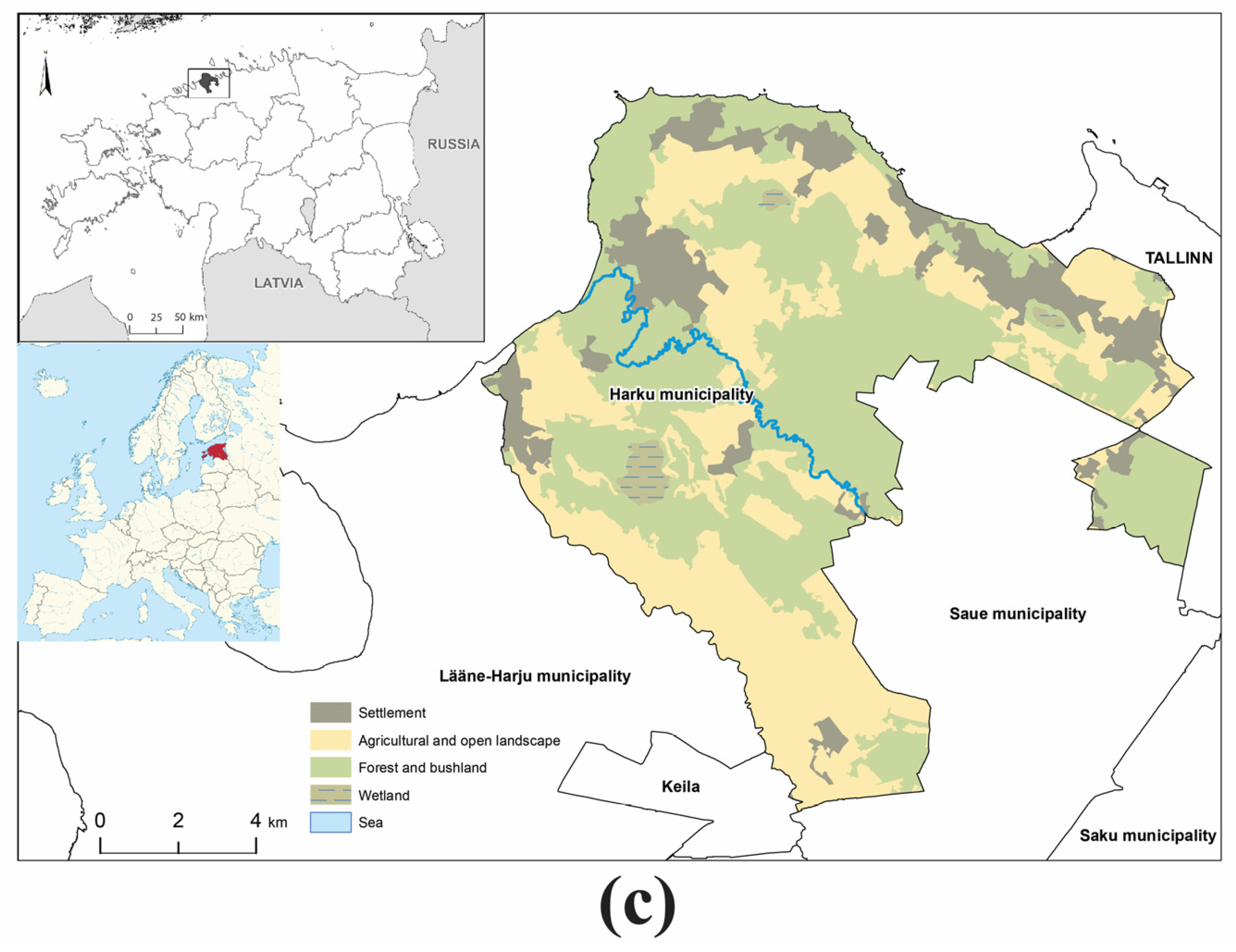
Study Area—Harku Municipality, Estonia

Harku is a rural municipality (Estonian: Harku vald) in Harju County, located directly west of Tallinn on the southern shore of the Gulf of Finland. It spans approximately 159.7 km2, stretching from the Tallinn boundary to the Gulf of Finland, with a coastal escarpment (klint) including notable cliffs at Rannamõisa and Türisalu totalling a 22 km shoreline. The population of Harku parish in 2023 was 17,520: roughly 11,000 people reside in five larger settlements, the rest are scattered among smaller villages with fewer than 100 residents [43]. The settlement pattern of the study area combines peri-urban developments, especially in the areas closer to Tallinn (capital of Estonia) and a rural landscape mosaic, where smaller villages are intermixed with farmland, meadows, and forests. In more remote areas traditional rural settlement forms are still visible. Harku parish is rich in cultural heritage sites (totalling 172), notably archaeological sites, historic manor centres, and lighthouses in the coastal areas.

2.2. Framework for ChatGPT-Assisted LCA Text Generation

In this research, we designed and developed a four-step prompt framework simulating a landscape expert’s brief for an inquiry to formulate a textual description of landscape character areas, as a key component of an LCA. This approach aims to maximise output clarity, reduce prompt noise, and support repeatability across different users (Figure 2). The full text of the four prompts used in this framework is provided in the Supplementary Materials (Table S1).
Step 1: Task Explanation and Context Setting
The first prompt served solely to introduce the task. In this step, we instructed ChatGPT (version GPT-4o) that the goal was to generate textual descriptions of landscape character areas, aligned with LCA principles. To avoid overloading the model with instructions in a single interaction, we deliberately kept this prompt focused on task orientation, based on our prior trials, where simpler and more focused inputs tended to produce clearer and more relevant responses. To help ChatGPT adhere to established LCA frameworks, and minimise the influence of its internal training data, we provided four reference documents, including both Estonian and English sources, which describe LCA methodology and its application. The references used were Eesti Maastikud (Estonian Landscapes) by Ivar Arold [44], European Landscape Character Areas by Dirk M. Wascher [8], a technical handbook on Landscape Character Assessment by Worcestershire County Council [45], and An Approach to Landscape Character Assessment by Christine Tudor [21]. We asked the model to familiarise itself with these sources and treat them as guiding material. At the end of this prompt, we clarified that the actual input data would follow in the next step.
Step 2: Input data and description generation
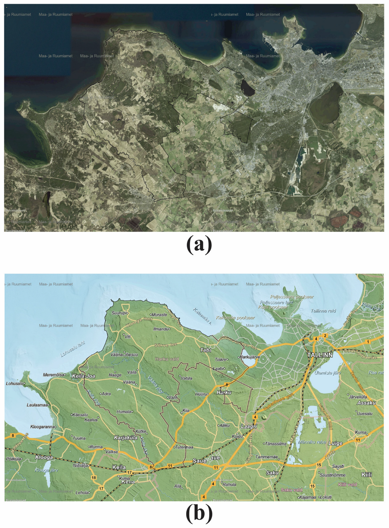
In the second step, we provided structured inputs describing a specific landscape character area, including satellite images, base maps, and predefined areas representing landscape character types (Figure 3 and Figure 4). These inputs were static and non-interactive, i.e., PNG images and PDFs, and not derived from live GIS or remote sensing datasets. The task assigned to ChatGPT was to visually interpret the satellite image and assign each portion of the image to its appropriate landscape character type. It was then instructed to generate a detailed textual description of each area, following the LCA format and referring to the following components: (1) landform and topography; (2) land use and land cover; (3) vegetation types; (4) settlement patterns; (5) visual and perceptual qualities. Prompt elements were manually structured by the authors based on visible features in the images and contextual references.
Each run was conducted independently by the four authors using their own ChatGPT accounts, following the same two-step protocol. The outputs were stored for later comparison and evaluation.
In an optional step, and for a clear demonstration of the results, we asked ChatGPT to reorganise the descriptions of all landscape character areas into a table format using the following columns: (1) area number/type; (2) landscape character name; (3) key visual and spatial features; (4) ecological or cultural notes; (5) perceptual qualities.
To ensure comparability across different test sessions, all authors used the same version of ChatGPT, GPT-4o, accessed via the web interface at chat.openai.com on 25 June 2025. All tests were in English, even though an Estonian reference was included, to control the variation caused by language differences and to ensure that the outputs could be easily reviewed and compared. Although each author ran the tests independently, the prompt wording and input format were kept identical across all sessions to inspect consistency and allow for later pattern comparison.

2.3. Scenario Building Through Integrating a Local Development Plan

To explore the potential impact of future changes on the landscape character on a municipal scale, we extended our framework to include a fourth prompt focusing on scenario building and the identification of forces of change, which built upon the outputs of prompts one to three, where landscape character areas were identified and described.
The fourth prompt tasked ChatGPT to generate narrative scenarios for the entire study area, using the municipality development plan “Harku Municipality Development Plan 2025–2040” [43] as the main reference for scenario building. The prompt required the formulation of three scenario narratives representing worst-case, zero-change, and best-case future scenarios. The prompt, also, asked for the identification of key forces of change for each scenario, including demographic, political, environmental, economic, and/or technological trends cited in the referred planning document. By doing that, we intended to frame the scenarios within possible trajectories of change. We aimed, through the scenario building prompt, to smoothly shift from a descriptive text in the first three prompts to an interpretative foresight.

2.4. Reliability Assessment of the ChatGPT-Assisted LCA Text Generation

We utilised ChatGPT to aid in evaluating the reliability of the proposed framework. Once the outputs of prompts one, two, and four were retrieved from each author, we reintroduced these results into ChatGPT and instructed it to perform a comparative evaluation across two main dimensions: (1) linguistic consistency and coherence; (2) content accuracy.
The first dimension focused on identifying variations in vocabulary, terminology, phrasing, and structural clarity across the outputs produced by different authors using identical prompts and input data. The second dimension assessed the thematic alignment of the outputs.
As part of this process, ChatGPT was instructed to synthesise a comparative overview of how each LCA component was addressed across different authors’ outputs. The resulting summary matrix (Table 1 in Section 3) presents the degree of terminology variation and example expressions, illustrating how consistently key components were described.
This comparison focused on the five key descriptive components described above used in standard LCA reporting, namely: (1) landform and topography; (2) land use and land cover; (3) vegetation types; (4) settlement patterns; (5) visual and perceptual qualities.

2.5. Stakeholder Role Play Perspective

To explore how different actors might interpret and utilise the generated landscape character descriptions, we incorporated a stakeholder role play using ChatGPT. In this step, the model was instructed to assume the perspective of ten stakeholder types relevant to landscape planning and development: LCA specialist, municipal planner, environmental NGO representative, local community member, landscape architecture developer, farmers and landowners, real estate developer, tourism operator, cultural heritage expert, and national authorities. Each stakeholder was asked to reflect on the outputs produced by the framework, considering their own interests, responsibilities, and professional or lived priorities.
This approach aimed to assess the perceived usefulness, clarity, and relevance of the outputs from multiple user perspectives. Responses were formatted as bullet points to reflect natural, role-specific observations, highlighting what each stakeholder might find valuable, lacking, or in need of adaptation. All responses can be found in the Supplementary Materials (Table S3).

3. Results

3.1. Overall Consistency

The results synthesise the content produced by all the authors using the methodology outlined above, focusing on how consistent, accurate, and structured the outputs are in relation to the LCA objectives. The analysis highlights patterns in language use, adherence to LCA components, and narrative construction across prompts.

3.1.1. Language Differences and Similarities Across the Authors’ Outputs from ChatGPT

The outputs generated by different authors using the same prompt framework revealed a high level of structural consistency but moderate variation in tone and linguistic expression. All authors followed the intended structure of the prompts.
The responses generated by ChatGPT maintained a descriptive tone in line with LCA reporting conventions and the documents attached at the beginning of the output generation. However, some responses were framed in language relevant to the discipline, while others were more generic.
Variability in the choice of terms was observed, with some answers containing expressions such as “settlement fabric” or “landscape mosaic,” while others used more generic alternatives like “built area” or “mixed land use.” Terminology related to vegetation, like “broadleaf forest,” “mixed woodland,” or “tree cover,” and land use categories showed small but relevant distinctions.
The sentence complexity also varied. Some answers contained compound or complex sentences that combined multiple observations in a single paragraph, while others showed more segmented sentence structures, listing observations more concisely. Phrasing style also varied, with some descriptions using more interpretative verbs, such as “suggests,” “reflects,” “defines,” while others used more observational phrasing like “contains,” “includes”, and “is characterised by”.
Despite the linguistic differences, all authors’ answers maintained internal logical flow within each prompt response. Prompt 1 responses were brief and straightforward across all authors. In prompt 2, structural consistency was strongest—most responses followed the prescribed sub-sections, though some varied in the order or emphasis of elements. For instance, the ChatGPT-generated answers of one author often emphasised settlement and human activities, while others prioritised natural features or perceptual qualities. Prompt 4, being more interpretative, allowed more stylistic freedom, which led to diversity in tone and structure, particularly in how scenario narratives were framed.

3.1.2. Content Accuracy

The content was assessed for accuracy by evaluating the alignment of each response with the intended LCA structure and objectives.
In prompt 1, we examined the model’s ability to correctly identify the task and reflect on the provided reference materials. All four responses acknowledged the task appropriately and referred to the documents as instructed. ChatGPT, regardless of the author initiating the prompt, confirmed its understanding and provided a brief summary of the relevance of the materials. While the summaries differed slightly in tone and depth, none misrepresented the sources or misunderstood the assignment, as stated in the ChatGPT outputs.
For prompt 2, we assessed whether the five key LCA components were adequately covered: (1) landform and topography; (2) land use and land cover; (3) vegetation types; (4) settlement patterns; (5) visual and perceptual qualities
Each author’s ChatGPT session included structured landscape character descriptions, addressing all five components to varying degrees. Table 1 summarises the degree to which each LCA component was consistently addressed and the extent of terminology variation across the responses.
Landform and topography were addressed in all responses, although the level of detail differed. Some responses used nuanced terminology such as “gentle slopes” or “elevated ridgelines,” while others used broader descriptions like “hilly” or “flat terrain.” Land use and land cover was consistently present, with all responses accurately identifying major land uses such as agricultural areas, residential areas, and mixed-use landscapes. Vegetation types were generally consistent, though some responses employed more specific ecological terms, e.g., “mixed coniferous woodland,” while others used broader descriptors like “tree-covered area.” The settlement patterns were observed in all responses, with variation in the depth and terminology of habitation descriptions. Some characterised the area as “largely unsettled” or having “minimal development,” which broadly aligned with one another. However, one description used the term “uninhabited,” which implies the complete absence of human presence and thus represents a stronger claim. Some descriptions also offered more analytical insight into spatial configuration like “ribbon development” and “dispersed villages,” while others provided simpler summaries. Visual and perceptual qualities were included in all responses but varied in depth. Some included elements such as “open views to the coast,” which, while objectively measurable through visibility analysis, can carry subjective meaning. Others presented simpler observations like “limited visual access.” Despite these variations, all essential LCA components were addressed in a coherent manner, demonstrating strong internal consistency and alignment with the expected LCA methodology.

3.2. Scenarios

Building on the landscape descriptions generated in prompts 1 and 2, the responses produced under prompt 4 introduced future-oriented content. All outputs provided structured scenario narratives and identified relevant external forces of change, as instructed. Each output included a set of three scenarios reflecting potential development trajectories for Harku Municipality. Although the scenario categories were predefined in the prompt, their interpretation showed internal consistency and remained closely aligned with the contents of the development plan. The style varied, with some responses adopting narrative-driven tones while others relied on bullet-pointed formats. However, the substance of all scenario narratives remained within scope and could reflect the planning document’s priorities.
In prompt 4, all responses successfully produced the three requested scenario narratives—worst-case, zero-change, and best-case—aligned with the “Harku Municipality Development Plan 2025–2040” [43]. The worst-case scenarios referenced uncontrolled development, environmental degradation, and cultural landscape loss. While the zero-change scenarios described status quo conditions with no significant interventions, the best-case scenarios outlined sustainable and coordinated development paths with cultural sensitivity and ecological integration.
Each response also identified relevant forces of change, including demographic trends, e.g., population growth or ageing, political and planning interventions, environmental pressures like biodiversity loss and land fragmentation, economic influences like investment levels and land value dynamics, and technological shifts such as infrastructure development.
Forces of change were addressed in all responses (see Section 3.1.2) and presented using a mix of narrative exposition and bullet-point format. All responses demonstrated accurate reference to the development plan and reflected an understanding of the key drivers influencing spatial development.
A noticeable transition was observed from descriptive landscape reporting (as in prompt 2) to foresight-oriented thinking. The responses consistently captured this shift, delivering coherent and forward-looking content while maintaining relevance to the LCA context. Table 2 summarises the recurring themes and notable differences in the scenario narratives generated for prompt 4.

3.3. Stakeholder Role Play

The stakeholder role play exercise provided insights into how different actors may interpret and assess ChatGPT-generated LCA descriptions based on their interests, expertise, and responsibilities. Across the ten stakeholder perspectives, the responses demonstrated a recognition of the framework’s utility and an awareness of its limitations. Table 3 provides a comparative overview of the main themes and concerns raised by each stakeholder group.
ChatGPT in the role of professional users, namely LCA specialists and municipal planners, found the outputs structurally coherent and useful for initiating early-stage planning. It emphasised the tool’s potential as a draft generator; however, it underlined the need for expert validation, especially where alignment with local legal or policy frameworks is required, as well as an essential step in all uses of AI-generated content to ensure trustworthiness. ChatGPT in the role of environmental NGOs and cultural heritage experts acknowledged the inclusion of ecological and historical elements but noted that intangible heritage, place memory, biodiversity priorities, and conservation risks were under addressed, calling for greater depth in these dimensions.
In the role of stakeholders with operational and/or commercial interests, i.e., the real estate developers, tourism operators, and farmers and landowners, it highlighted the tool’s ability to support site analysis, identify development constraints/risks, and frame long-term planning considerations. However, it also highlighted that some outputs lacked place specificity and practical details required for feasibility studies or subsidy applications. From a public perspective role, i.e., local residents, it appreciated the use of scenarios to imagine future change but requested more accessible language and greater attention to lived experiences, such as walking paths or social areas. In the role of national authorities, it viewed the consistency and structure of outputs as being supportive of strategic planning and policy monitoring, though it emphasised the need for a better alignment with national targets and terminology.

4. Discussion

4.1. Reflections on Language Differences and Similarities in ChatGPT Outputs

The prompt structure was followed consistently by all authors, resulting in structurally coherent outputs. The generated language revealed strong variation in tone, terminology, and phrasing. These differences did not compromise the clarity or usability of the descriptions but highlighted the influence of author-specific interaction styles and interpretive nuances within a shared prompt framework. This variability echoes the subjectivity observed in traditional human-led LCA processes. As noted by Tudor [21] and Butler [40], landscape descriptions inherently involve individual interpretation, and different practitioners may place emphasis on varying elements depending on disciplinary background or contextual knowledge. In this study, ChatGPT mirrored the linguistic preferences and focus areas of each user, despite using the same base prompts. This suggests that GenAI does not eliminate subjectivity but rather translates it through the lens of user input; an important consideration in ensuring repeatability and reliability in LCA automation.
At the same time, the internal logic and consistency of the outputs indicate that with a well-designed prompt structure, the tool can maintain coherence while allowing style flexibility. This reflects findings by Zwangsleitner et al. [27] and Alkhateeb et al. [23,24], who found that structured prompt design plays a central role in guiding AI-generated content. Despite the fact that AI models often function as ‘black boxes’ [29], ChatGPT’s outputs in this study remained interpretable and traceable to the prompt components.
By highlighting how user–AI interaction shapes the generated text, this study contributes to ongoing discussions about authorship and consistency in GenAI-supported landscape work. It addresses gaps in current AI–LCA literature, where the influence of prompt authorship and variation in descriptive expression have not yet been systematically examined. Future applications may benefit from standardised prompt protocols and collaborative refinement to balance consistency with contextual nuance.

4.2. Opportunities and Added Value of Using AI in LCA

The findings demonstrate that ChatGPT offers promising support in generating structured and coherent textual descriptions within the LCA framework. When guided by carefully constructed prompts and supplemented with relevant and known reliable reference material, the tool produced outputs that were internally consistent and aligned with established LCA structures. This confirms the potential of GenAI to support specific LCA tasks, particularly those that are time-consuming or repetitive, such as drafting descriptive text; such value is similarly observed in AI-supported visualisation workflows by [25,27,28,31,35].
The capacity of this GenAI tool to simulate future-oriented scenario narratives extends its relevance beyond descriptive tasks, indicating potential for foresight exercises in planning contexts. This aligns with Zwangsleitner et al. [27] and Liu [26], who found that ChatGPT could be integrated into creative and planning-oriented educational settings. However, while previous studies have largely focused on design pedagogy or visual workflows, this research investigates a new application area by adapting GenAI for structured policy-relevant text generation in LCA—a contribution that has not been explored in existing literature.
The stakeholder role play exercise, conducted via ChatGPT and informed by ten simulated user perspectives, revealed a broad recognition of the tool’s value across professional, operational, and public domains. Some simulated interpretations aligned with the authors’ own reflections, suggesting internal consistency, but at the same time, raise the possibility of bias occurrence [24]—where outputs may have echoed rather than challenged the assumptions embedded in the input prompts. The simulated stakeholders identified clear benefits in streamlining workflows, supporting early-stage assessments, and initiating participatory dialogue. However, the absence of unexpected views highlights the limits of simulation and the need for real stakeholder input to uncover context-specific insights rather than generic generalisations. These findings expand the evidence base for the practical integration of GenAI into planning and assessment workflows, addressing concerns raised in prior studies (e.g., [29,30]) about the accessibility and applicability of AI tools in non-specialist or resource-constrained contexts. Moreover, the outputs produced requiring less time for manual LCA text production than was evidenced in Nevzati’s [33] work, where the desk-based workload would exceed the capacity of an under-resourced municipality. This confirms the advantage of increased efficiency gained by using GenAI. It also supports the broader argument found in e.g., Reddy & Janga [35], that GenAI enables professionals and students to focus on more analytical or strategic dimensions of their work by reducing the time spent on routine tasks.
Overall, this study fills a notable gap in the literature by applying GenAI to the textual dimension of LCA, illustrating how it can complement human expertise while enhancing efficiency and accessibility across planning and educational domains, aligning with the authors’ reflections.

4.3. Limitations and Risks of ChatGPT-Assisted LCA

ChatGPT produced structurally consistent and largely usable outputs; however, its effectiveness remains closely tied to the specificity and quality of input prompts. Minor inconsistencies across author-generated outputs—despite shared prompt frameworks—highlight the model’s sensitivity to embedded context and user phrasing. This supports prior observations by Kim & Lee [25], who noted variation in GenAI performance depending on how prompts are articulated, even when used within structured tasks. The current study extends these concerns into the LCA domain, demonstrating that even with standardised procedures, AI output framing can vary slightly vary depending upon prior user engagement with the software.
The stakeholder role play exercise further revealed that while the tool captured broad character elements and speculative scenarios, it lacked depth in conveying ecological specificity, cultural nuance, and spatial accuracy—dimensions critical for planning applications and typically grounded in local knowledge. Qin et al. [30] and Huang et al. [29] noted that their automated classification models improved efficiency and objectivity; however, it struggled to address the interpretive and contextual depth required in landscape work. Our research responds to this by offering a more accessible, dialogue-based GenAI method that retains the potential for expert and stakeholder input.
A more nuanced risk identified in this study is the potential shift from an expert-dominated process [40] to one overly reliant on AI-generated content. Without clear mechanisms for integrating expert review and local stakeholder engagement, there is a danger that efficiency gains may come at the expense of participatory and contextual richness. If the time saved by automation is not reinvested in stakeholder dialogue or qualitative inquiry, the democratic and place-based ethos of LCA—emphasised in Tudor [21] and the ELC [7]—could be undermined.
Our study underscores the importance of positioning ChatGPT as a supplementary tool. Its value lies not in replacing expert analysis but in reducing routine labour to enable deeper public engagement and critical reflection. In doing so, the integration of GenAI in LCA could align more closely with the inclusive and interpretive goals of landscape planning.

4.4. Technical Reliability and the Role of Expert Knowledge

ChatGPT performed well in replicating structural patterns and responding to the prompt framework; nevertheless, its outputs are based on linguistic pattern recognition rather than grounded field expertise or critical judgement. During testing, differences across author outputs were not attributable to prompt wording—since a shared structure was used—but rather to contextual factors such as prior interactions within the ChatGPT session. This variability illustrates how the tool can mirror user-specific framings or terminology preferences, even within a consistent protocol. However, this sensitivity underscores the importance of implementing standardised prompting practices to minimise across-practitioner variations, especially if this approach is to be adopted at scale in professional or institutional settings.
These findings underpin Huang et al.’s [29] concerns, who noted that the “black box” nature of AI models compromises transparency, possibly undermining trust in results. Qin et al. [30] similarly highlighted that although automation can reduce the dependence on expert interpretation, the absence of contextual and local knowledge remains a limitation. Moreover, as noted in Tudor [21] and Terkenli et al. [22], human-led LCA requires interpretive synthesis that integrates biophysical features as well as perceptual and cultural values; dimensions that AI tools cannot authentically evaluate.
Therefore, while ChatGPT can effectively structure and draft preliminary descriptions, its application must remain under expert supervision. Professionals are needed to validate ecological and cultural specificity, ensure terminological consistency, and contextualise outputs within the landscape’s planning and cultural specificities and in accordance with local regulations. In addition, expert involvement is critical for adapting descriptions to participatory planning contexts, where language, tone, and relevance shape public understanding and engagement. As such, AI should be regarded not as a substitute for expertise, but as a support tool that frees up time for more meaningful human interpretation and interaction.
The responsibility for AI-generated content remains a critical concern. AI users must ultimately verify and take ownership of outputs [38], particularly in planning contexts where decisions carry real-world implications. Yet, we argue that responsibility is not exclusive to end-users but should be the responsibility taken by all operators, including users, developers [36], and the institutions that should bear a duty to ensure transparency and provide adequate safeguards. The ethical use of GenAI in landscape assessment requires institutional frameworks that promote accountability across all levels of deployment.

4.5. Time Efficiency and Human Relationships in the Shadow of AI-Assisted LCA

ChatGPT proved to be time-saving during the drafting and analysis phases of LCA, particularly in contexts with limited staffing or technical capacity. This reflects broader findings in the literature that promote GenAI’s potential for reducing routine workload, allowing professionals to concentrate on creative or strategic tasks [25,28,35]. In this study, the tool successfully automated the textual component of the assessment, producing structured outputs that could otherwise take a considerable amount of time.
Landscape character is not merely a technical output. As defined in the ELC [7], landscapes are “perceived by people,” emphasising the co-constructed and experiential nature of landscape knowledge. This subjectivity is grounded in local values, memories, and interpretations, which require interaction, negotiation, and empathy which cannot be simulated by AI. The stakeholder role play, particularly from community and cultural heritage perspectives, revealed that the perceived legitimacy of an LCA is anchored in trust, dialogue, and lived experience. These relational aspects—often achieved through fieldwork, consultation, and collaborative processes—remain irreplaceable.
This integration of the social dimension into LCA, encouraged by the ELC, however, should not be treated as a procedural requirement alone. It should recognise how places are valued and experienced, reflecting the understanding that landscapes are not only physical but also lived and interpreted. Meaningful stakeholder involvement is often limited by context-specific challenges such as political will, institutional capacity, and/or cultural norms but also often time constraints. As Fairclough et al. [3] note, LCA was developed for English conditions; therefore, it should not be directly transferred without adaptation to local contexts. Calls for social integration must be accompanied by a genuine commitment to inclusive practice. Moreover, stakeholder groups themselves are not fixed. In diverse or rapidly changing societies, their composition and interests can shift over time, with some voices only emerging during specific phases of development. This variability underscores the need for flexible engagement strategies that go beyond initial assessments and adapt to evolving social dynamics.
While the automation of LCA text generation may free up time, the challenge lies in how this time is reinvested. Underpinning concerns from Butler [40], there is a risk that AI use may reinforce a top-down, expert-driven process unless the saved resources are redirected toward broader engagement. The true added value of AI in LCA lies in efficiency and its potential to enable more participatory, inclusive processes by reducing technical burdens and opening space for dialogue. Therefore, human relationships must remain at the core of landscape assessment, with AI serving as a facilitator, not a replacement, of human connection.

4.6. Limitations, Opportunities, and Future Directions

This study presents a first step in applying ChatGPT to generating textual outputs for LCA. However, several limitations emerged that constrain the generalisability and scope of the findings. The research was conducted within a single Estonian municipality and used English-language prompts. While this ensured control over variability, it may limit the cultural and linguistic sensitivity of the framework when applied in multilingual or more diverse settings. Moreover, although multiple authors tested the prompt structure, the number of user sessions and variations remained relatively small. A broader and more diverse user base, especially involving practitioners from different planning backgrounds, would allow for a more robust validation of the framework’s applicability.
While this study primarily focused on reliability—namely, the consistency of outputs generated using a standardised framework—it did not perform a full validity test in the external sense. Specifically, we did not compare the ChatGPT-generated outputs with a professionally prepared LCA that was not referenced or used in the prompt. Future research could incorporate such a comparison to assess the external validity and practical applicability of AI-generated landscape descriptions.
Another limitation stems from the reliance on AI-simulated stakeholder engagement. While the role play generated a spectrum of potential stakeholder responses, these were AI-derived rather than grounded in real-time consultation with community members or planning professionals. No real-world expert or stakeholder validation of the outputs was conducted in this study, which represents a critical next step for assessing their practical relevance and credibility. Future work should incorporate participatory methods such as interviews, workshops, or field testing to assess the perceived legitimacy and clarity of the generated texts. It is worth noting that we caution that such simulations, if misused, could risk overlooking the meaningful public involvement that the ELC calls for, thus, GenAI should complement—not replace—dialogue, trust building, and participatory planning but facilitate the dialogue required for a robust output.
In terms of scope, this study did not aim to automate the delineation of landscape character areas themselves, with the spatial boundaries being predefined based on previous research outcomes prior to engaging ChatGPT. The focus was on automating the textual description of these areas. However, the potential role of AI in earlier stages, like proposing tentative character area boundaries using geospatial, textual, or image-based inputs, remains an important avenue for future exploration. Additionally, the framework employed static spatial inputs, i.e., PNG images, and predefined reference materials. It did not integrate with dynamic datasets such as real-time GIS layers, remote sensing outputs, or sensor-based environmental monitoring, all of which could significantly enhance its responsiveness and relevance in practical planning contexts.
This study promotes the potential of GenAI to support LCA in resource-scarce contexts; however, we recognise that actual deployment faces significant barriers, including limited digital literacy. Realising the benefits of such tools in these communities would require an investment in capacity building and the dissemination of digital knowledge.
The framework included visual and perceptual qualities as part of the AI-generated descriptions; however, these elements showed the greatest variability and subjectivity. Given their interpretive nature, such qualities would be better addressed through stakeholder engagement rather than automated processes. It should be noted that this also applies to expert driven analysis too [40]. Future applications could focus AI efforts on physical attributes, while reserving perceptual aspects to participatory methods, which the time-saving aspect facilitates. The use of GenAI introduces a risk of inaccuracies, commonly referred to as “hallucinations” [32] (p. 38). Even when outputs are structured and readable, they may include misstatements; thus, future applications should include fact-checking or participatory review mechanisms to ensure that AI-generated descriptions are intelligible and accurate. The authors acknowledge the ethical implications of using GenAI in planning contexts and sought to mitigate risks by providing verifiable inputs, including recognised spatial data, standardised definitions, and visual references. While this does not fully eliminate inaccuracies, it demonstrates a commitment to responsible AI use and transparency in the human–computer interaction process.
This study also lacks a longitudinal perspective. There was no assessment of how the framework performs across multiple planning cycles or whether it can accommodate evolving landscape conditions. To build on these findings, future research should apply the framework across varied biogeographic and cultural settings, testing its adaptability to different planning systems. Co-development with stakeholders is essential to ensure grounded outputs, and comparative studies should evaluate ChatGPT-generated descriptions alongside expert-authored texts. Integration with GIS workflows could also unlock new opportunities for semi-automated and updatable textual outputs. Furthermore, the educational potential of this framework merits exploration, particularly in assessing its impact on student learning, critical thinking, and creativity. Finally, further investigations should explore alternative large language models and multimodal AI approaches that combine text generation with visual or spatial outputs, enabling more holistic support for landscape characterisation and scenario building.

5. Conclusions

This research explored the potential of ChatGPT as a GenAI tool to support the writing of textual descriptions in LCA. Using a structured prompt framework tested within the context of Harku Municipality in Estonia, the results showed that the tool was capable of generating coherent, thematically appropriate, and internally consistent texts. The outputs effectively followed the five standard LCA components and demonstrated structural alignment across different authors, despite minor variations in tone and terminology. In addition to descriptive outputs, the framework enabled scenario building linked to development plans, offering a way to expand LCA from static documentation toward more dynamic, forward-looking planning. The stakeholder role play, conducted through ChatGPT, further illustrated how AI-generated content might be interpreted across different user perspectives. While these simulations provided useful insights, they also underscored the importance of expert judgement, cultural awareness, and stakeholder engagement in maintaining the relevance and legitimacy of LCA. The findings support the use of GenAI as a complementary tool in landscape planning, particularly in contexts where time or resources are limited. However, this study also highlighted the risks of oversimplification and the limitations of AI in capturing ecological detail, spatial specificity, and lived experience. The proposed framework should therefore be understood not as a replacement for expert-led processes but as a means to reduce routine workload and create more space for reflection, dialogue, and inclusive participation.

6. Recommendations

Planning organisations and academic institutions are encouraged to pilot structured prompt-based workflows using ChatGPT or similar GenAI tools to support the initial drafting of landscape character descriptions. These structured prompts can improve consistency and reduce the time required to produce baseline texts, especially in data-scarce or resource-limited contexts. Such workflows offer immediate practical value when integrated within expert review processes. To ensure long-term relevance in resource-scarce communities, such initiatives, as previously mentioned, should be accompanied by investments in digital access, capacity-building, and locally grounded implementation strategies.
AI-generated outputs should not replace professional judgement or stakeholder engagement. Instead, they should serve as early drafts that can be adapted and refined through field knowledge and community dialogue. This ensures that local specificity, cultural meaning, and lived experience remain central to the spirit of landscape planning processes, as outlined in the ELC.
There is also a need to integrate AI literacy into planning and design education. Training students to use generative tools critically—including prompt design, verification of outputs, and collaborative review—will prepare them to engage with emerging digital workflows without diminishing interpretive and conceptual thinking. Future research should also explore statistical consistency by running repeated prompt sessions to assess variability and identify potential patterns or biases in AI-generated outputs.
As a long-term recommendation, planning authorities and professional bodies should consider developing shared prompt templates and guidance protocols tailored to regional planning systems and landscape typologies, alongside improving the application of participatory methodologies. While this would require coordinated efforts, it could enhance transparency, repeatability, and consistency in AI-assisted LCA outputs over time and improved stakeholder engagement.

Supplementary Materials

The following supporting information can be downloaded at: https://www.mdpi.com/article/10.3390/land14091842/s1, Table S1: Full text of the four prompts; Table S2: ChatGPT-generated lca descriptions and scenarios (prompt responses); Table S3: Stakeholder role play perspectives.

Author Contributions

Conceptualization, G.A. and M.V.; methodology, G.A. and M.V.; formal analysis, G.A., M.V., J.T.S. and M.K.; writing—original draft preparation, G.A. and M.V.; writing—review and editing, G.A., M.V., J.T.S. and M.K.; visualisation, G.A. All authors have read and agreed to the published version of the manuscript.

Funding

This research was funded by the Estonian Government Scholarship for Doctoral Students—G.A.

Data Availability Statement

Due to planned future analyses, the full database is not publicly available at this stage. However, relevant excerpts are provided in the Supplementary Materials.

Acknowledgments

We thank Fiona Nevzati for her work on Landscape Character Assessment in Estonia, which helped contextualise our study area and supported with the visual material. The use of ChatGPT (OpenAI, version GPT-4o) is described in the Methodology and was central to the generation and evaluation of LCA content. The authors have reviewed and edited the output and take full responsibility for the content of this publication.

Conflicts of Interest

The authors declare no conflicts of interest.

Abbreviations

The following abbreviations are used in this manuscript:
LCALandscape Character Assessment
LCILandscape Character Identification
AIArtificial Intelligence
GenAIGenerative Artificial Intelligence
ELCEuropean Landscape Convention

References

  1. Sauer, C.O. Morphology of Landscape; University of California Press: Berkeley, CA, USA, 1925; Available online: https://www.scribd.com/doc/256866389/Sauer-1925-Morphology-of-Landscape (accessed on 28 July 2025).
  2. McHarg, I.L. Design with Nature; Wiley: Hoboken, NJ, USA, 1969. [Google Scholar]
  3. Fairclough, G.; Herlin, I.S.; Swanwick, C. (Eds.) Routledge Handbook of Landscape Character Assessment: Current Approaches to Characterisation and Assessment, 1st ed.; Routledge: London, UK, 2018; Available online: https://www.routledge.com/Routledge-Handbook-of-Landscape-Character-Assessment-Current-Approaches-to-Characterisation-and-Assessment%20/Fairclough-SarlovHerlin-Swanwick/p/book/9780367502171 (accessed on 28 July 2025).
  4. Swanwick, C. Landscape Character Assessment: Guidance for England and Scotland-Topic Paper 1: Recent Practice and the Evolution of Landscape Character Assessment; Scottish Natural Heritage: Edinburgh, UK; The Countryside Agency: Cheltenham, UK, 2002. Available online: https://www.parcopopiemontese.it/documenti/paesaggio/dwd/lineeguida/lca.pdf (accessed on 28 July 2025).
  5. Bell, S. Landscape pattern, perception and visualisation in the visual management of forests. Landsc. Urban Plan. 2011, 54, 201–211. Available online: https://www.sciencedirect.com/science/article/pii/S0169204601001360 (accessed on 28 July 2025). [CrossRef]
  6. Bell, S. Landscape: Pattern, Perception and Process; Routledge: London, UK, 2012; Available online: https://www.taylorfrancis.com/books/mono/10.4324/9780203120088/landscape-pattern-perception-process-simon-bell (accessed on 28 July 2025).
  7. Council of Europe. Council of Europe Landscape Convention; Council of Europe: Strasbourg, France, 2002; Available online: https://rm.coe.int/16807b6bc7 (accessed on 15 December 2024).
  8. Wascher, D.M. European Landscape Character Areas: Typologies, Cartography and Indicators for the Assessment of Sustainable Landscapes; Landscape Europe: Wageningen, The Netherlands, 2005; Available online: https://library.wur.nl/WebQuery/wurpubs/reports/376380 (accessed on 28 July 2025).
  9. Baas, H.; Groenewoudt, B.; Raap, E. The Dutch Approach. In The European Landscape Convention; Jones, M., Stenseke, M., Eds.; In Landscape Series; Springer: Dordrecht, The Netherlands, 2011; pp. 45–66. [Google Scholar] [CrossRef]
  10. Nijhuis, S.; Reitsma, M. Landscape policy and visual landscape assessment. Res. Urban. Ser. 2011, 2, 229–259. [Google Scholar] [CrossRef]
  11. Bruns, D.; Stemmer, B. Landscape assessment in Germany. In Routledge Handbook of Landscape Character Assessment; Routledge: London, UK, 2018. [Google Scholar]
  12. Franchi, A.; Raymond, R.; Luginbühl, Y.; Seguin, J.-F.; Grare, H. Méthode Pour L’identification, la Caractérisation et la Qualification des Paysages; Ministère de l’Écologie, du Développement Durable et de l’Énergie: La Défense, France, 2015.
  13. Kurs, O. Elusid ja Eluruume. In Ilmatargad; Ilmamaa: Tartu, Estonia, 2009. [Google Scholar]
  14. Granö, J.G. Eesti Maastikulised Üksused; Regio: Tartu, Estonia, 1922. [Google Scholar]
  15. Granö, J.G. Maastikuteaduse Ülesanded ja Maastiku Vormide Süsteem. Acta Comment. Univ. Tartu. Dorpat. 1924. Available online: https://dspace.ut.ee/items/a242a514-08f2-477a-9db3-eebf418f38b2 (accessed on 28 July 2025).
  16. Kant, E.; Kurs, O.; Runnel, S.; Ombler, S. Eesti Rahvastik ja Asustus; Ilmamaa: Tartu, Estonia, 2007. [Google Scholar]
  17. Kant, E. Linnad ja maastikud; Ilmamaa: Tartu, Estonia, 1999; Available online: https://www.vanaraamat.ee/Edgar_Kant_Koostanud_ja_jarelsona_Ott_Kurs_Linnad_ja_maastikud_Ilmamaa_1999_35524-21.htm (accessed on 29 July 2025).
  18. Tammiksaar, E.; Pae, T.; Kurs, O. A continuity of ideas? salme nõmmik, edgar kant and the development of economic geography in soviet Estonia. Geogr. Ann. Ser. B Hum. Geogr. 2013, 95, 51–70. [Google Scholar] [CrossRef]
  19. Pae, T. Formation of Cultural Traits in Estonia Resulting from Historical Administrative Division; Tartu University Press: Tartu, Estonia, 2006; Available online: https://dspace.ut.ee/bitstreams/f30f06a2-984c-4e7f-89e9-bb22ef4e38e0/download (accessed on 29 July 2025).
  20. Nevzati, F.; Veldi, M.; Külvik, M.; Bell, S. Analysis of Landscape Character Assessment and Cultural Ecosystem Services Evaluation Frameworks for Peri-Urban Landscape Planning: A Case Study of Harku Municipality, Estonia. Land 2023, 12, 1825. [Google Scholar] [CrossRef]
  21. Tudor, C. An Approach to Landscape Character Assessment. 2014. Available online: https://assets.publishing.service.gov.uk/media/5aabd31340f0b64ab4b7576e/landscape-character-assessment.pdf (accessed on 29 July 2025).
  22. Terkenli, T.; Gkoltsiou, A.; Kavroudakis, D. The Interplay of Objectivity and Subjectivity in Landscape Character Assessment: Qualitative and Quantitative Approaches and Challenges. Land 2021, 10, 53. [Google Scholar] [CrossRef]
  23. Alkhateeb, G.; Storie, J.; Külvik, M. Post-Conflict Urban Landscape Storytelling: Two Approaches to Contemporary Virtual Visualisation of Oral Narratives. Land 2024, 13, 406. [Google Scholar] [CrossRef]
  24. Alkhateeb, G.; Storie, J.; Bell, S.; Suškevičs, M. Virtual Imaginative Geographies: Generative AI and the Representation of Landscape Imagery. Geographies 2025, 5, 9. [Google Scholar] [CrossRef]
  25. Kim, J.; Lee, Y. Accuracy Evaluation of Tree Images Created Using Generative Artificial Intelligence. J. Digit. Landsc. Archit. 2024, 2024, 1029–1037. [Google Scholar] [CrossRef]
  26. Liu, X. Integrating Generative AI into Landscape Architecture Education: Methodologies, Applications, and Ethical Considerations. J. Digit. Landsc. Archit. 2024, 2024, 937–945. [Google Scholar] [CrossRef]
  27. Zwangsleitner, F.; Habjanič, G.; Knegendorf, A. AI as a Tool in the Landscape Architecture Design Process. J. Digit. Landsc. Archit. 2024, 2024, 987–994. [Google Scholar] [CrossRef]
  28. Fernberg, P.; George, B.H.; Chamberlain, B. Producing 2D Asset Libraries with AI-powered Image Generators. J. Digit. Landsc. Archit. 2023, 2023, 186–194. [Google Scholar] [CrossRef]
  29. Huang, T.; Zhao, H.; Huang, B.; Li, S.; Zhu, J. Integrating Natural Language Processing With Vision Transformer for Landscape Character Identification. IEEE J. Sel. Top. Appl. Earth Obs. Remote Sens. 2025, 18, 5838–5852. [Google Scholar] [CrossRef]
  30. Qin, W.; Li, W.; Zhang, Z.; Chen, W.; Wan, M. Landscape Character Classification with a Deep Neural Network: A Case Study of the Jianghan Plain. Land 2024, 13, 2024. [Google Scholar] [CrossRef]
  31. Ho, L.-C. LaDeco: A tool to analyze visual landscape elements. Ecol. Inform. 2023, 78, 102289. [Google Scholar] [CrossRef]
  32. Hicks, M.T.; Humphries, J.; Slater, J. ChatGPT is bullshit. Ethics Inf. Technol. 2024, 26, 38. [Google Scholar] [CrossRef]
  33. Nevzati, F. Evaluating Ecosystem Services and Their Impact on Human Well-Being in the Peri-Urban Landscape of Harku Municipality, Estonia. Ph.D. Thesis, Estonian University of Life Sciences, Tartu, Estonia, 2024. [Google Scholar] [CrossRef]
  34. Savilaakso, S.; Burgas, D.; Cantú, I.; Cassidy, E.; Dix, G.; Ekroos, J.; Green, E.; Hua, F.; Klimas, C.; Krishnan, S.; et al. State of Knowledge Regarding How We Can Improve Adherence to the Mitigation Hierarchy, with a Particular Focus on the Avoid Stage; Zenodo-CERN: Geneva, Switzerland, 2023. [Google Scholar] [CrossRef]
  35. Reddy, K.; Janga, J.K. Utilization of Generative Artificial Intelligence in Geotechnical and Geoenvironmental Engineering; Springer Nature: Singapore, 2025. [Google Scholar] [CrossRef]
  36. European Union. Artificial Intelligence Act; Publications Office of the European Union: Luxembourg, 2023; Volume P9_TA(2023)0236. Available online: https://eur-lex.europa.eu/legal-content/EN/TXT/HTML/?uri=CELEX%3A52023AP0236 (accessed on 4 September 2025).
  37. Floridi, L.; Cowls, J. A Unified Framework of Five Principles for AI in Society. Harv. Data Sci. Rev. 2019, 1, 1–15. [Google Scholar] [CrossRef]
  38. OpenAI. OpenAI: Terms of Use. Available online: https://openai.com/en-GB/policies/row-terms-of-use/ (accessed on 3 September 2025).
  39. UNDP. Hamburg Declaration on Responsible Artificial Intelligence (AI) for the Sustainable Development Goals (SDGs); UNDP: New York, NY, USA, 2025; Available online: https://www.bmz-digital.global/wp-content/uploads/2025/06/250603_Hamburg_Declaration.pdf (accessed on 29 July 2025).
  40. Butler, A. Dynamics of integrating landscape values in landscape character assessment: The hidden dominance of the objective outsider. Landsc. Res. 2016, 41, 239–252. [Google Scholar] [CrossRef]
  41. Calderon, C.; Butler, A. Politicising the landscape: A theoretical contribution towards the development of participation in landscape planning. Landsc. Res. 2020, 45, 152–163. [Google Scholar] [CrossRef]
  42. Butler, A.; Berglund, U. Landscape Character Assessment as an Approach to Understanding Public Interests within the European Landscape Convention. Landsc. Res. 2014, 39, 219–236. [Google Scholar] [CrossRef]
  43. Harku Municipality. Harku Valla Arengukava 2025–2040. 2022. Available online: https://www.riigiteataja.ee/aktilisa/4081/1202/4038/vvk_2024_m_12_Lisa_3.pdf (accessed on 29 July 2025).
  44. Arold, I. Eesti Maastikud; Tartu Ülikooli Kirjastus: Tartu, Estonia, 2005; Available online: http://hdl.handle.net/10062/16805 (accessed on 29 July 2025).
  45. Worcestershire County Council. Landscape Character Assessment Supplementary Guidance Technical Handbook. 2013. Available online: https://gis.worcestershire.gov.uk/website/LandscapeCharacter/Documents/lca%20th.pdf (accessed on 29 July 2025).
  46. Estonian Land Board. Geoportal|Estonian Land and Spatial Development Board. Available online: https://geoportaal.maaamet.ee/eng/ (accessed on 29 July 2025).
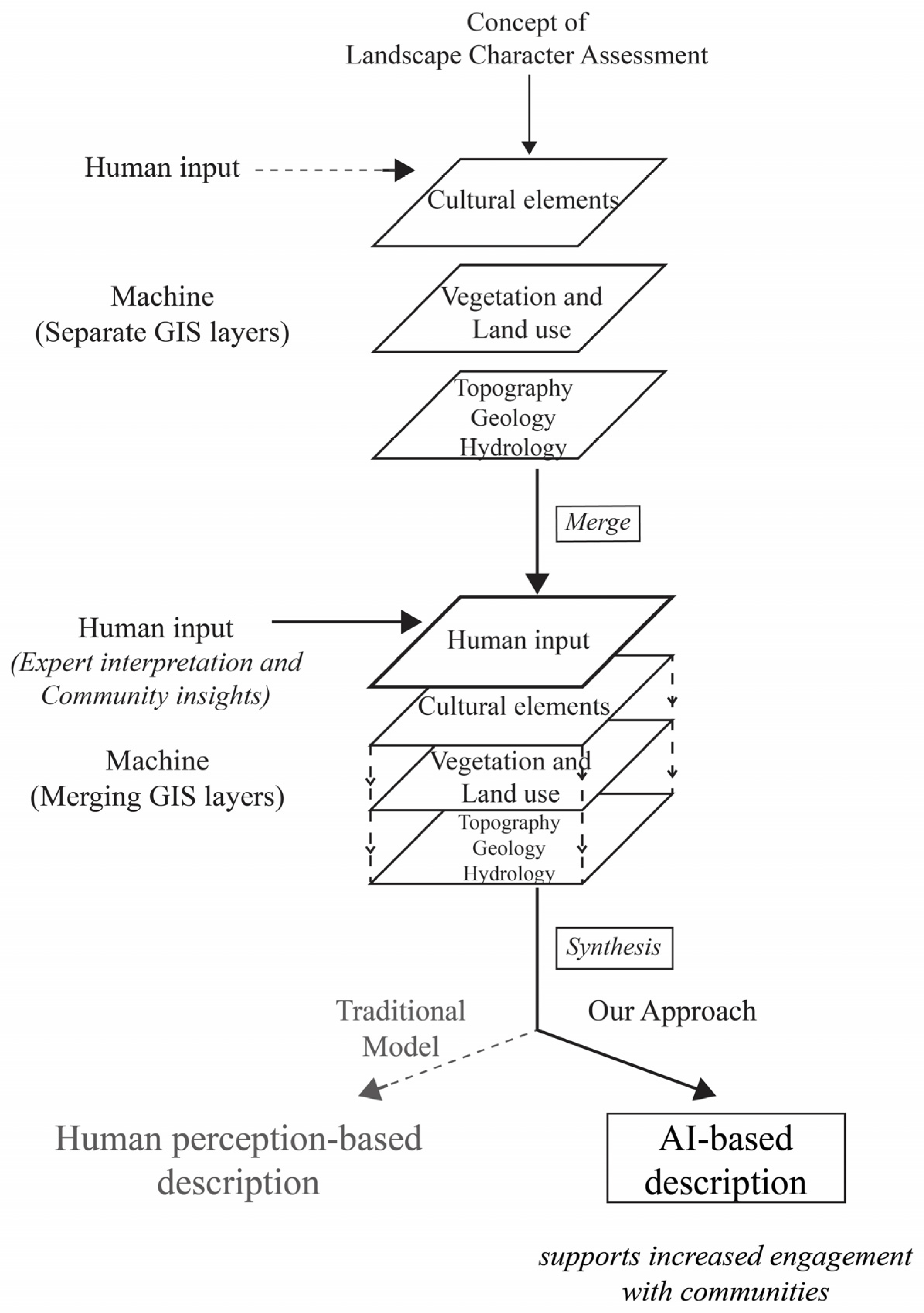
Figure 1. Conceptual model of Landscape Character Assessment (LCA) showing the integration of machine-generated spatial data with expert and community inputs. The AI-assisted approach supports efficient synthesis while allowing time for enhanced stakeholder engagement by providing descriptions for dialogue between stakeholders and experts.
Land 14 01842 g001
Figure 2. Prompt-based framework for ChatGPT-assisted LCA text generation. The process includes four main prompts: task introduction, interpretation of static visual landscape data, i.e., map images, optional table-format presentation, and scenario building. Reference materials and spatial/planning inputs were fed into corresponding prompts to guide content generation and ensure methodological alignment with reliable sources. The outputs from each prompt were collected for comparison and analysis. (See the Supplementary Materials (Table S2)).
Land 14 01842 g002
Figure 3. Overview maps of Harku Municipality, Estonia, used in prompt 2. (a) Orthographic satellite image showing the physical terrain and land cover. The colours reflect natural surface features as captured by the base imagery and do not follow a classification scheme; (b) road network (yellow lines) and settlement locations (labelled by name in situ); (c) simplified land use classification highlighting settlements, agricultural areas, forests, and wetlands. Base maps: Estonian Land Board [46].
Land 14 01842 g003aLand 14 01842 g003b
Figure 4. Landscape Character Assessment outputs for Harku Municipality, used in prompt 2. (a) Delineated landscape character areas (LCAs) with corresponding area codes and descriptive categories; (b) aggregated landscape character types (LCTs) based on dominant land cover, settlement patterns, and natural features. Base maps: Estonian Land Board [46].
Land 14 01842 g004aLand 14 01842 g004b
Table 1. Consistency and variation across authors’ ChatGPT outputs.
LCA ComponentTerminology VariationExample Terms (Specific vs. Broad)
Landform and TopographyStrong“gentle slopes” vs. “hilly terrain”
Land Use and Land CoverModerate“agricultural areas”, “mixed-use”, etc.
VegetationStrong“mixed coniferous woodland” vs. “tree-covered area”
Settlement PatternsStrong“uninhabited”, “ribbon development”, “minimal development”
Perceptual QualitiesVery strong“open views to the coast” vs. “limited visual access”
Table 2. Scenario narrative themes observed in ChatGPT-generated outputs.
Scenario TypeCommon Themes Across All ResponsesVariation in Thematic Focus
Worst-CaseUncontrolled development, environmental degradation, cultural landscape lossTraditional land use loss, visual degradation, urban sprawl, habitat fragmentation
Zero-ChangeContinuation of existing patterns, lack of intervention, stable but stagnant landscape conditionsSocio-political stagnation, missed ecological opportunities, neutral landscape trajectory
Best-CaseSustainable growth, ecological integration, cultural sensitivity, improved planning coordinationNature-based solutions, cultural revitalisation, mobility enhancement, spatial zoning reform
Table 3. Stakeholder role play—summary of perceived strengths and concerns.
Stakeholder RolePerceived Value of ChatGPT-Generated OutputsConcerns Raised
LCA SpecialistUseful for early-stage drafting; supports education; scenario narratives offer planning foresightTerminology inconsistency; uneven perceptual/cultural coverage; need for expert review
Municipal PlannerSupports early planning discussions; builds shared language; helpful for staff briefingsLanguage too academic; lacks links to practical planning elements
Environmental NGO RepresentativeHighlights environmental pressures; supports advocacy and awarenessInsufficient biodiversity detail; generalised language may obscure sensitive dynamics
Local Community MemberRelatable landscape features; helps visualise future change; useful for consultationsComplex terminology; lacks attention to daily life and lived experiences
Landscape Architecture DeveloperInforms site context and early design; scenario use in adaptive strategiesInsufficient spatial specificity; needs stronger alignment with design practice
Farmers and LandownersAccurate land use/topography; identifies landscape pressures affecting farmingLimited regulatory focus; subsidy implications not addressed
Real Estate DeveloperIdentifies growth areas; useful for early investment scopingDescriptions too general; unclear spatial detail; permit alignment unclear
Tourism OperatorIdentifies scenic potential; reflects visitor-relevant changesLimited focus on accessibility and recreation infrastructure
Cultural Heritage ExpertReferences historical elements; potential for baseline scopingIntangible heritage underrepresented; weak heritage risk framing
National AuthoritiesSupports strategic alignment; scenario foresight for spatial policyNeeds better policy language alignment; missing links to national targets
Disclaimer/Publisher’s Note: The statements, opinions and data contained in all publications are solely those of the individual author(s) and contributor(s) and not of MDPI and/or the editor(s). MDPI and/or the editor(s) disclaim responsibility for any injury to people or property resulting from any ideas, methods, instructions or products referred to in the content.