Abstract
This paper investigates the design of a coastal cycling route that integrates principles of sustainable mobility with the perceptual qualities of the urban landscape. In response to contemporary environmental challenges, the promotion of cycling as an alternative mode of transport necessitates the development of urban green infrastructure that is not only functionally adequate but also perceptually engaging. The research draws upon established theoretical frameworks, particularly the concepts of spatial legibility and visual sequencing articulated by Kevin Lynch and Gordon Cullen, to examine how the experience of landscape can influence cycling behavior in urban development. Methodologically, the study combines a comprehensive literature review with a spatial and perceptual analysis of a selected coastal corridor in the Attica region in Greece, extending from Kallithea to Glyfada. The route is segmented into types based on physical, visual, and sensory characteristics, allowing for targeted design interventions. Key variables such as enclosure, vegetation, noise levels, and visual accessibility are evaluated to inform design strategies that enhance user experience and safety. The findings suggest that incorporating perceptual design elements into cycling infrastructure can significantly contribute to increased usage, environmental sustainability, resilience, and the overall improvement of urban coastal environments.
1. Introduction
In recent decades, the rapid urbanization of coastal cities has led to growing concerns about environmental sustainability, urban livability, and the need for alternative, human-centered transportation networks. Among these, cycling is increasingly recognized as an effective and sustainable mode of mobility that supports ecological, economic, and public health goals [1,2]. Notably, cycling—similar to other forms of physical exercise—has positive effects on human health [3], particularly when it involves active travel through natural settings [4]. Additionally, recent studies demonstrate the importance of nature and green infrastructure as a promising pathway to enhance cycling in cities, and they highlight the links between urban green planning and environment-friendly mobility policies [5]. Green streetscapes contribute to increased cycling participation along with the associated benefits for health and well-being [5]. Leisure cycling habits tend to be influenced by the visual appeal of an area, the form and quality of the built environment [6], and the presence of an appropriate infrastructure and safety measures [3,7].
Within this context, the design and implementation of cycling infrastructure—especially in complex urban environments like coastal zones—requires not only functional efficiency but also an understanding of how space is perceived and experienced by users [8]. Nevertheless, the impact of urban natural landscape on how it is perceived and valued for cycling remains largely understudied [5]. Urban mobility systems worldwide are being re-evaluated in light of climate change, rising energy costs, and public health crises related to sedentary lifestyles [9]. Cities are facing significant pressure to reduce carbon emissions, encourage physical activity, and reclaim public space from automobile dominance. Cycling infrastructure, when well integrated and thoughtfully designed, contributes directly to these goals. However, many existing urban cycling systems are inadequate or fragmented, or they fail to consider the qualitative, experiential dimensions of movement through space [10], and green infrastructure is often either underestimated or poorly incorporated into the urban corridors’ cycling design. Moreover, infrastructure designed purely for technical performance—such as continuity or pavement quality—often neglects the user’s visual, spatial, and emotional experience of the route [11,12].
Recent urban design theory highlights the importance of perception and experience in shaping mobility choices. Kevin Lynch, in his seminal work The Image of the City, emphasized how people understand and navigate the city through legible spatial forms—paths, edges, districts, nodes, and landmarks—that collectively form mental maps [13]. Gordon Cullen’s Townscape introduced the idea of “serial vision,” a conceptual framework for understanding how space unfolds dynamically as one moves through it [14]. These theories, while formulated in the mid-20th century, remain profoundly relevant to modern transport and landscape design, especially in contexts where cycling infrastructure must engage the senses and emotions of users to encourage regular use [15,16].
This research attempts to address a neglected but critical link between perception, landscape quality, and sustainable mobility. It adds to the literature by offering a landscape-based, multisensory design framework that is both context-specific (Athens coast) and broadly applicable to other urban and coastal cycling projects. Coastal urban corridors, such as the Attica coastline in Greece, offer both opportunities and challenges for sustainable transport interventions. Their adjacency to natural elements like the sea and their linear structure make them promising candidates for continuous, scenic cycling routes [17]. The case study of the Kallithea–Glyfada coastal corridor is of international interest since it reflects urban challenges common to many metropolitan waterfronts, including rapid urbanization and spatially fragmented and competing land uses along high-traffic arteries [15]. Situated at the threshold between the city and the sea, the corridor illustrates how mobility systems can integrate everyday functionality with recreational and ecological values. Therefore, the paper aims to present a landscape design and planning approach where landscape and nature are the catalysts for the cycling infrastructure design. The selected case study focuses on the design of a perceptually rich and ecologically sustainable coastal cycling route between Kallithea and Glyfada—two municipalities within the metropolitan area of Athens. The objective is to develop a typology-based design framework that enhances the visual, spatial, and functional characteristics of the route, making it safer, more attractive, and more legible to diverse user groups [18,19,20].
While much has been written about the functional aspects of cycling infrastructure—such as safety, surface quality, or intersection design—less attention has been paid to how users feel while cycling through specific environments. Perception, spatial quality, and the broader landscape experience are often marginalized in engineering-focused planning paradigms. However, these factors can be decisive in whether a person chooses to cycle regularly [18,19,20]. According to recent studies in environmental psychology and urban behavior, spaces that are perceived as pleasant, safe, and stimulating tend to attract higher levels of pedestrian and cycling traffic [21]. Thus, designing with perceptual quality in mind can be seen not as a luxury but as a strategic necessity for shifting transportation behavior [22].
Research in this domain has evolved in several directions. On one hand, some scholars focus on the integration of green infrastructure and urban ecosystems into mobility planning, suggesting that cycling routes can act as ecological corridors and contribute to climate resilience [23,24,25]. Others emphasize the role of human-centered design, calling for deeper engagement with social and experiential factors in transport planning [26]. Meanwhile, debates continue over whether the prioritization of aesthetics and landscape perception undermines the technical efficiency of infrastructure or whether it, in fact, strengthens it by promoting usage, public acceptance, and long-term sustainability [15].
In this theoretical and methodological research, the current study advances a hybrid approach that merges landscape architecture, spatial perception theory, and sustainable mobility planning and aims to contribute not only to local planning discussions but also to broader debates on the role of perception and experience in transport design. By foregrounding the user’s sensory and emotional journey through the landscape, the project advocates for an expanded understanding of cycling infrastructure—one that integrates aesthetics, ecology, and spatial meaning. In doing so, it aligns with emerging global discourses on the “right to mobility” and the democratization of urban space [27].
This research seeks to address the following core question: How can a coastal cycling route be designed to optimize both sustainable transport efficiency and the perceptual quality of the urban landscape? In responding to this question, the study highlights the value of perceptual analysis, landscape typology, and user-centered planning as tools for creating meaningful, functional, and engaging public infrastructure. The conclusions suggest that cycling routes, when thoughtfully designed, can act not only as corridors of movement but also as immersive experiences—narratives through which the city and the landscape are perceived, understood, and appreciated. The study enhances the corpus of scientific knowledge in landscape architecture by analyzing experiential and perceptual qualities as key to shaping mobility choices, aligning with the foundational work of Lynch and Cullen. Vegetation is also shown to be a multifunctional element, enhancing not just aesthetics but also environmental comfort and sensory experience, and a perceptual design approach—focused on how infrastructure is seen and felt—can strengthen technical performance, encouraging safer, more inclusive, and sustainable cycling behavior.
2. Materials and Methods
2.1. Study Area
The area of the proposed cycling route is geographically located in the Regional Unit of South Attica in Greece and passes through six municipalities of the urban complex: Kallithea, Alimos, Argiroupoli-Elliniko, and Glyfada (Figure 1). The choice of this corridor is both strategic and symbolic. Strategically, the corridor serves as a potential backbone for a larger sustainable mobility network in Attica. Symbolically, it represents a threshold between the urban and the natural, between everyday functionality and recreational experience. The route traverses areas of diverse character—high-density neighborhoods, cultural landmarks, underutilized waterfronts, and open parks—each presenting specific challenges and potentials. A successful design must navigate these transitions gracefully, ensuring both continuity and contextual sensitivity.
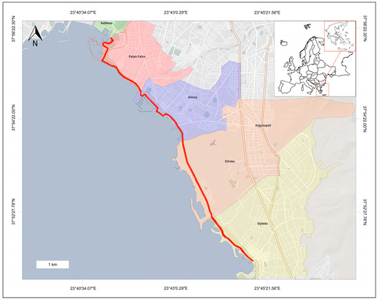
Figure 1.
The suggested cycling route (red line) and the municipalities that it passes through.
The wider area has shown slight population growth since 2011, with Kallithea being the most densely populated municipality [28]. Its terrain includes mountains, plains, rivers, and complex coastlines, while the geology consists mainly of marine and brackish deposits. The climate is Mediterranean, mild, and coastal to dry.
The proposed cycling route begins in the municipality of Kallithea at the termination point of the existing cycling path, and it extends to the municipality of Glyfada. The route spans approximately 12 km (Figure 1) and follows one of the most heavily trafficked avenues in Athens, named Poseidonos Avenue.
Most of the land uses around the route are recreational, with urban green space, marinas, and touristic/leisure activities (Figure 2). An important restriction of the chosen area, in terms of having access to the proposed design and/or suggesting ideas/interventions, is that a part of it (gray colored in Figure 2) is “The Ellinikon” project, which is under construction; thus, for this specific part, only a brief reference will be made.
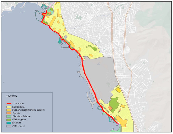
Figure 2.
Land uses of the area around the route.
The following points along the route are provided as examples of the proposed cycling route (Figure 3).
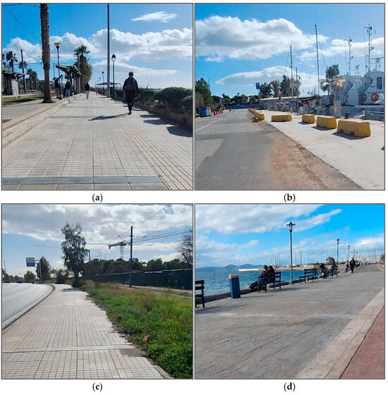
Figure 3.
Example segments of the route. (a) A section where the tram line lies on one side and the sea on the other; (b) a part of the marina, with a small park on one side and the sea on the opposite side; (c) a point along the route where an avenue without protective barriers borders one side, and the tram line runs along the other; (d) a segment of the pedestrian pathway, with a park on one side and the sea on the other.
Regarding the morphology of the cycling route, certain segments are considered hazardous (Figure 4), primarily due to their close proximity to Poseidonos Avenue and, consequently, the increased vehicular traffic or the tram line. Nevertheless, several other factors also contribute to the lack of safety in the existing conditions. These include insufficient sidewalk width, passage through public squares or shared-use low-traffic roads, and narrow or constrained sections of the route.
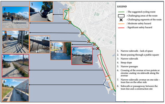
Figure 4.
The image illustrates the key high-risk areas/points along with the specific conditions that render these segments either difficult to navigate or potentially unsafe for users.
In terms of vegetation, this area features a variety of plant species, including evergreen trees such as pine (Pinus spp.), cypress (Cupressus spp.), and Brachychiton; evergreen shrubs such as oleander (Nerium oleander), viburnum (Viburnum spp.), and photinia (Photinia spp.); and deciduous trees including mulberry (Morus spp.), Judas tree (Cercis siliquastrum), plane tree (Platanus spp.), and tamarisk (Tamarix spp.). Bougainvillea (Bougainvillea spp.) is also commonly present throughout the area.
Regarding the perceptual properties of the site, the coastal cycling route offers extensive views toward the sea along one side. The opposite side runs adjacent to roadways that range from low to high traffic. This spatial configuration creates a visual and experiential contrast between the natural coastal landscape and the urban built environment. Such divergence may result in a fragmented perception of the surroundings, potentially causing disorientation for users who are simultaneously exposed to the cityscape and the open horizon. However, this same contrast can also produce a positive experiential effect, as the unobstructed sea view fosters a sense of detachment from the urban setting—evoking feelings of relaxation and escapism within the city’s fabric, near the user’s residence.
The predominant source of noise is vehicular traffic, particularly in sections of the route that run adjacent to high-speed roads. Sound, however, is not inherently negative; its impact depends on both intensity and source. Natural sounds—such as rustling leaves and flowing water—have been shown to positively influence human well-being. In the case of the study area, the sound of waves is considered a beneficial sensory component, enhancing the overall user experience rather than detracting from it. The extent to which natural sounds prevail over artificial ones—namely those generated by passing vehicles—depends on a range of factors, such as the time of day (with vehicular noise being lower at night), the season (with traffic volumes typically increasing during the summer), and the specific segment of the route (for instance, whether the cycling path adjoins a major avenue or a low-traffic street). Accordingly, the overall cycling experience is directly shaped by these variables.
In sections of the route that run adjacent to roads and avenues, the strong presence of exhaust fumes creates an unpleasant olfactory environment for both cyclists and pedestrians. Conversely, areas located near the sea offer a more favorable sensory experience, where the scent of saltwater, combined with expansive views of the horizon, evokes a sense of calm and enjoyment.
The tactile dimension of the route primarily relates to the construction materials used for the pavement and the surrounding environment. During the site survey, materials such as asphalt, concrete pavers, sidewalk tiles, and cement were recorded in the existing conditions. Surface texture plays a critical role in the cycling experience. Rough or uneven terrain can hinder movement, while certain materials may absorb excessive heat, leading to discomfort for cyclists. For these reasons, the use of natural materials is considered the most appropriate choice, as they offer improved thermal performance and a more pleasant tactile experience.
2.2. Method
The method focuses on a proposed typology of the cycling route into distinct experiential zones—allowing for context-sensitive interventions that enhance both functionality and perceptual richness [20]. To support the design framework, the study draws on a range of theoretical sources and empirical observations.
The methodological process is summarized in a step-by-step flowchart (Figure 5). It outlines the sequence from literature review and fieldwork, through the coding of indicators (e.g., sea views, noise, safety, vegetation, infrastructure), to the classification of five landscape types from which the design proposals were derived (Figure 5).
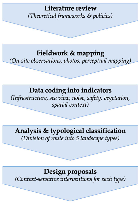
Figure 5.
Flowchart of the methodological process.
Before presenting the proposed intervention, it was deemed appropriate to first illustrate the existing conditions on a map, compiled from a combination of sources, including the literature review, Kevin Lynch’s theory as outlined in his book The Image of the City, satellite imagery, the desk analysis of the study area, and on-site fieldwork. As such, the conceptual base includes Lynch’s principles of legibility and imageability [8], Cullen’s approach to sequential space [9], and more recent works on green mobility and perceptual urbanism [21].
The various landscape character types are defined through on-site analysis, focusing on environmental conditions (noise, vegetation, enclosure), visual characteristics (views, openness, landmarks), and spatial transitions (from dense urban fabrics to open waterfronts). Empirical input is derived from field visits, mapping (using AutoCAD), photographic documentation, and environmental analysis (e.g., sound levels, visual corridors, vegetation types), which took place in January and August of the year 2024, at various times throughout the day, in order to obtain a holistic understanding of the environment, particularly in relation to seasonal, temporal, and weather-related conditions. Regarding the literature review, research was conducted on published studies and articles using different databases (e.g., articles from scientific journals, university library repositories). Many keywords used during our search related to the topics of landscape architecture, landscape design, and cycling routes in coastal urban environments. Although there is extensive literature on cycling routes and green infrastructure, it was observed that sources addressing cycling routes with the specific characteristics of the present study (e.g., both coastal and urban) were limited. Some exemplary keywords that were “landscape design cycling paths,” “landscape design city bike lanes,” “coastal cycle lanes landscape,”. The year of publication was not a primary criterion, provided that the information was valid. Particular emphasis was placed on the theory of Kevin Lynch, and specifically on his book The Image of the City, as it constitutes the principal reference for the present study.
Based on the above, the route was divided into segments that share common characteristics, forming the basis for a typological classification. This typology will inform the development of the final route proposal, approached from the perspective of landscape architecture and guided by the overarching principles of design.
Initially, the current state of the route was mapped, identifying the segments that traverse sidewalks, pedestrian streets, accompanying corridors, or existing bicycle lanes. Following this, the five fundamental elements proposed by Kevin Lynch (paths, edges, nodes, districts, and landmarks) were mapped, along with two additional perceptual elements, as previously described: the visual and the auditory.
Although in the visually dominated world, the cycling experience is a multisensory phenomenon [29,30,31,32], for the purpose of this research, some specific senses were likely left out, and the focus was given to the visual and auditory qualities influencing the cycling experience. Specifically, within the visual dimension, the focus was placed on mapping the view toward the sea, while within the auditory dimension, the emphasis was on the noise produced by motorized vehicles. These choices were not made arbitrarily. This emphasis is supported both theoretically and empirically. Theoretically, the urban design and environmental psychology literature highlight vision and sound as central to how people perceive and navigate urban environments [6,13,14,21]. Empirical studies further show that visual attractiveness and noise levels strongly affect perceived safety, comfort, and the overall appeal of cycling routes [5,19]. Field observations in the study area reinforced these insights: open sea views were consistently associated with positive feelings of relaxation and detachment from the urban setting, whereas traffic noise emerged as the dominant negative factor, particularly along high-speed sections of Poseidonos Avenue. In comparison, in our study, tactile and olfactory elements were found to have less variability or influence on cyclists’ choices. For this reason, visual and auditory dimensions were prioritized in the mapping and design considerations. On the detailed map (Figure 6), sea views are classified as enclosed, limited, or open, while noise levels are categorized as low, moderate, or high.
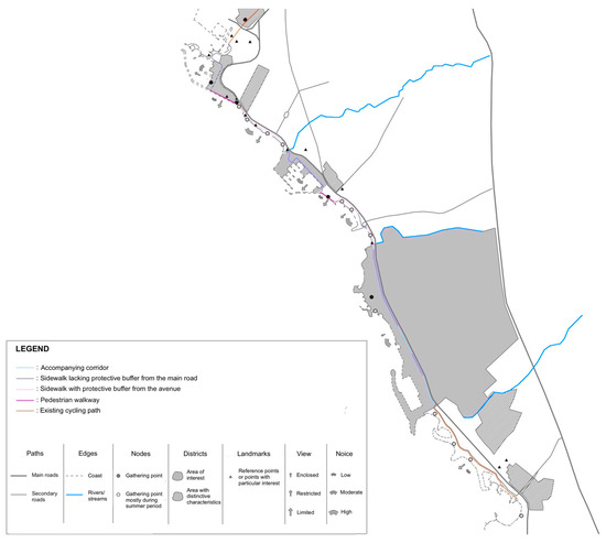
Figure 6.
Map of visual elements based on Lynch’s theory.
With regard to Lynch’s elements, it is important to note that, whereas in his original studies, the map elements emerged from the frequency of user responses in surveys; the mapping in this study is based exclusively on on-site personal fieldwork, as no questionnaire-based data collection was conducted.
The results of the literature review and field observations are a set of design guidelines for the cycling route, landscape types, and a detailed landscape design of each segment, demonstrating the importance of landscape in the cycling infrastructure design.
3. Results
3.1. General Design Principles
Based on the literature review regarding cycling routes and field observations, the following general design principles are proposed for the particular cycling route, which is situated between Poseidonos Avenue and the sea:
- Safety: Emphasize cyclist safety through complete separation from motor traffic, clear signage and markings, and careful material and vegetation choices that enhance both safety and experience [10,20,33].
- Comfort: Improve rider comfort using smooth surfacing, prioritizing cyclists at intersections, and implementing dedicated cycle tracks. Enhancing the environment with noise-reducing elements, natural materials, and visual buffers supports a more enjoyable ride [19,20,33].
- Attractiveness: Highlight landscape views and sensory experiences (e.g., sight, sound, smell, touch) and create points of interest that encourage interaction with the environment and other activities (e.g., bike parking near coastal recreation) [8].
- Legibility: Ensure the route is easily navigable through clear boundaries and signs, helping cyclists feel safe and oriented [11,13].
- Adaptability: Design the infrastructure to be flexible and capable of evolving over time in response to future changes, thereby enhancing the capacity of the system to preserve stability through adaptive responses to both endogenous dynamics and exogenous influences [34].
- Connectivity: Link the route with other cycling networks to allow access to varied landscapes, destinations, and recreational opportunities.
3.2. Elements Based on Lynch’s Theory
The Lynch elements, as they appear in this research, are presented below and in the adequate map (Figure 5):
- Paths: These were divided into primary and secondary roads. The only route considered as a primary path is Poseidonos Avenue, as it is the largest and most significant road in the study area and largely dictates the alignment of the cycling route. Secondary paths include other major roads that cross or border the study area.
- Natural Edges: Defined as the coastline and streams or small rivers. The coastline serves as the most prominent natural boundary, physically demarcating one side of the route (the other being defined by the avenue). Notable streams also function as natural boundaries and, in some cases, as administrative borders between municipalities.
- Nodes: Categorized into two types: those that attract people year-round (e.g., beaches) and those that attract crowds during summer months (e.g., squares and pedestrian streets). This classification was deemed essential for identifying existing or potential needs for infrastructure and activity planning.
- Districts: These were divided into areas of general interest—such as parks and city centers—and those with distinctive characteristics, particularly areas undergoing urban regeneration or redevelopment projects. For these areas, general references were made without detailing specific design proposals.
- Landmarks: Defined as locations of particular interest or symbolic importance within a neighborhood, including statues, monuments, and major churches, which serve as visual and cultural reference points.
Observing the compiled map, it becomes clear that several locations share similar spatial and perceptual characteristics. For example, a pedestrian zone with an open sea view, adjacent greenery, and social activity may exhibit strong experiential cohesion. Consequently, the route was divided into types, each encompassing different map points that share common features.
It is also important to note that hazardous segments of the route, as identified in Figure 4, were taken into account. Safety is arguably one of the most critical aspects of any cycling route. Additional parameters considered in the typological analysis include vegetation as well as the visual connection with the urban fabric and the built environment.
Furthermore, Lynch’s framework played a significant role in the segmentation of the route. Natural edges (e.g., streams), distinct areas, and path hierarchies often dictated the boundaries of each segment. In addition, nodes such as beaches or seasonal gathering places were typically concentrated within specific types.
3.3. Landscape Types
The analysis of the study area revealed recurring spatial and perceptual patterns that allowed the cycling corridor to be organized into distinct landscape types. This type (Figure 7) reflects differences in infrastructure, environmental conditions, and experiential qualities, and it forms the basis for developing context-sensitive design proposals.
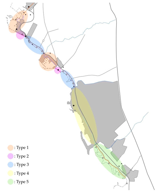
Figure 7.
Landscape types along the cycling route.
The five landscape types presented in Table 1 were derived through a combination of field observations, mapping, and perceptual analysis, applying both Lynch’s elements (paths, edges, nodes, districts, landmarks) and additional sensory indicators. Each segment of the route was classified according to infrastructure characteristics, spatial context, sea view accessibility, noise intensity, safety conditions, and vegetation quality. These indicators were systematically assessed to distinguish areas with shared features and experiential qualities, thereby forming coherent types. Table 1 summarizes these types, illustrating how the integration of physical, visual, and sensory variables informed the typological classification that underpins the subsequent design proposals.

Table 1.
Description of the five types derived from the analysis.
3.4. Design Proposals for Each Landscape Type
Design proposals for each landscape type are analyzed and presented in the following paragraphs.
- Type 1
The segments comprising the first type cover a total length of approximately 2.5 km (Figure 8).
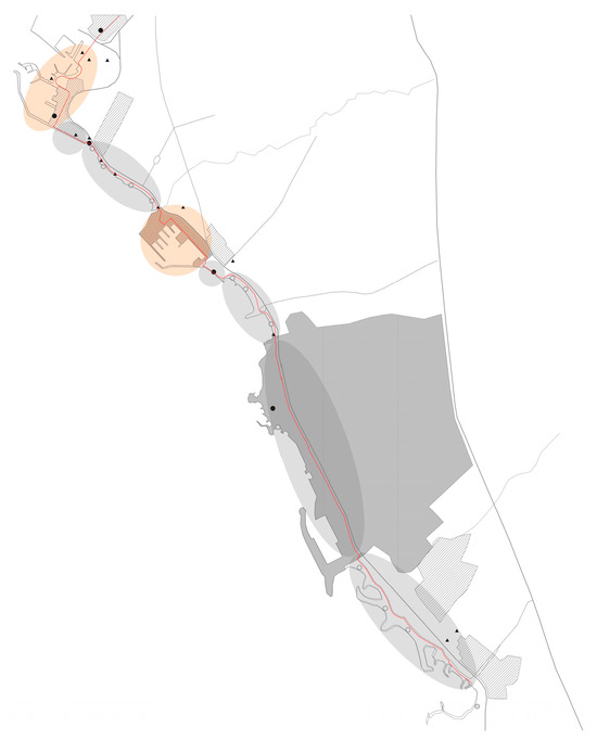
Figure 8.
Areas included in Type 1.
The similarities between these two segments are clear. Both are located in areas that feature marinas, recreational facilities, and points of interest. The current route in these sections follows low-traffic roads. In many locations, the view toward the sea remains open, while the opposite side of the route features green spaces, parks, playgrounds, and other recreational uses. The noise levels from the avenue remain moderate, as the vegetation acts as a natural sound barrier. Additionally, no significant noise pollution is observed from the adjacent low-traffic roads. While these segments are not considered highly hazardous, their proximity to roadways renders them moderately risky.
In this type of context, the proposal includes either the implementation of a cycle lane on the existing road surface or the creation of a dedicated two-way cycle track, depending on the available space. Furthermore, the removal of on-street parking along the side designated for the proposed cycle path is recommended, along with the introduction of one-way traffic regulation on the existing roadway, where feasible.
Planting may be utilized for multiple purposes: to define points of interest, to visually and physically separate the cycling route from vehicular traffic, to differentiate user groups (cyclists and pedestrians), and to enhance the aesthetic and environmental quality of the surrounding space.
In terms of comfort, surface materials and vegetation are critical. A red-colored asphalt is recommended due to its visibility and durability. Regarding planting, Mediterranean species are recommended to maintain consistency with existing vegetation. Given the proximity to roadways and the resulting air pollution from motor vehicles, emphasis should be placed on species that improve visual appeal (e.g., Jacaranda mimosifolia, Bougainvilea glabra, Teucrium fruticans) and air quality while providing pleasant scents (e.g., Rosmarinus officinalis, Jasminum grandiflorum, Lavandula angustifolia), thus enhancing the multisensory experience of the route. These choices also contribute to the attractiveness of the corridor, drawing users into an immersive experience along the waterfront.
In these segments, shrubs used for separating functions should not exceed a maximum height of one meter, in order to maintain visual continuity and user safety when transitioning between the cycle track, pedestrian path, or street. In many areas, tall trees are already present and provide ample shade. However, in zones where vegetation is inadequate, it is proposed to reinforce the planting scheme with taller tree species to increase shading and thermal comfort.
Legibility can be improved through the introduction of well-placed directional signage, textured paving at intersections, and targeted lighting installations. Given the dynamic recreational character of these spaces, the infrastructure must also accommodate adaptability. Modular installations such as mobile seating, art displays, or kiosks for refreshments can evolve with seasonal activities. Lastly, connectivity is vital. These segments should link directly to marinas, neighborhood green spaces, and secondary mobility networks to foster a seamless journey for cyclists.
As a result, the particular interventions focus on enhancing the multisensory experience of the route, improving the attractiveness of the corridor, and increasing shading and thermal comfort.
The plan view and cross-section of the proposed design for Type 1 are presented below (Figure 9).
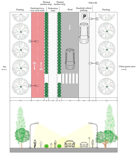
Figure 9.
Plan view and section of a selected location featuring a dedicated two-way cycle track.
- Type 2
The second type includes pedestrian-only coastal promenades in Palaio Faliro and Alimos, totaling roughly 800 m (Figure 10).
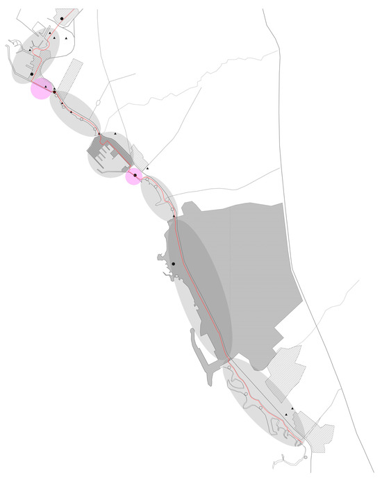
Figure 10.
Areas included in Type 2.
Although these are relatively short segments, they are considered the most scenic parts of the route. They consistently attract a large number of visitors throughout the year, primarily due to the presence of green spaces, various public amenities (such as an open-air cinema, playgrounds, outdoor theater, etc.), and their distance from roadways and motorized traffic. As a result, noise pollution from Poseidonos Avenue is negligible, and these areas are not considered hazardous for either pedestrian or cyclist circulation.
Given the ample available space (a width of approximately 10 m along their full length in both cases), the proposal for these segments involves the creation of a dedicated two-way cycle path. In general, the surrounding environment is deemed to be in good condition, though maintenance of the existing vegetation and targeted additions of planting material are recommended—particularly in the Palaio Faliro segment. The design approach here emphasizes aesthetic harmony and sensory stimulation while maintaining functional mobility.
A ceramic-paved cycle track is proposed to blend aesthetically with the promenade while ensuring a smooth ride. Plant species proposed for these locations are selected based on their tolerance to salinity, as the segments are located directly adjacent to the sea and are occasionally subject to saltwater spray. In this type, olfactory perception is already strongly influenced by the presence of salt in the air, making it less important to enhance that particular sensory experience. Therefore, the selected species focus on other senses, primarily vision (e.g., Acacia cyanophylla, Gazania spp., Myoporum laetum) and touch (e.g., Achillea maritima, Rosmarinus officinalis, Crithmum maritimum). The tactile element, in particular, is emphasized for the variety of textures that can enhance both individual plants and the overall planting composition. Additionally, since these are natural stopping points, it is expected that many cyclists will pause to enjoy the view or rest, offering them the opportunity to observe and engage more closely with the surrounding environment and planting design. Rest zones equipped with shaded benches and educational signage about the local flora and coastal ecology support both comfort and environmental engagement.
In terms of legibility, the delineation between pedestrian and cycling paths must be subtle but clear, achieved through color variation in materials, low planters, and embedded icons. The promenade’s modular layout lends itself well to adaptive design. Seasonal installations such as pop-up cafés or cultural displays can be accommodated without interfering with the primary cycling function. Connectivity is also crucial; the promenade must be linked to local park systems, coastal public transit stations, and adjacent community centers.
Overall, this type exemplifies how quiet, car-free segments can offer a deeply enriching and accessible cycling experience (Figure 11). It also proves that vegetation plays a significant role in connecting the observer with the surrounding environment.
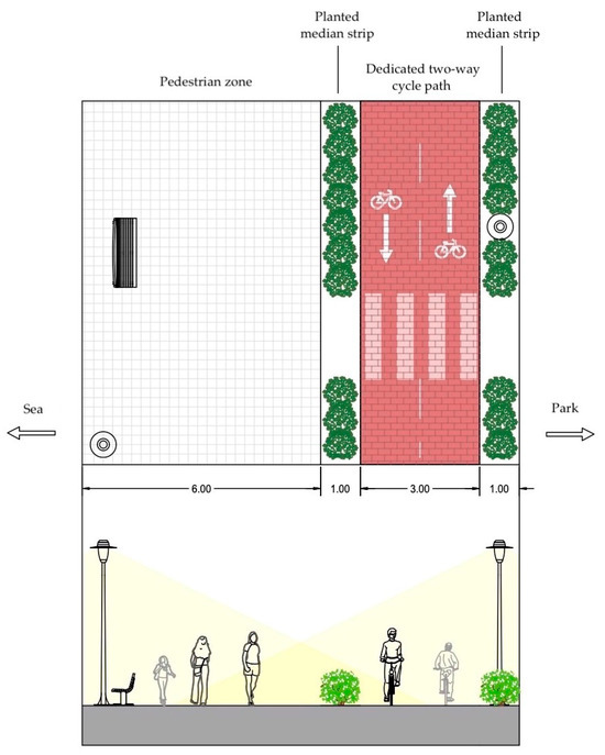
Figure 11.
Plan view and section of a random location featuring a dedicated two-way cycle track.
- Type 3
The third type is composed of approximately 2.5 km of coastal segments that run parallel to Poseidonos Avenue and adjacent tram lines (Figure 12).
Figure 12.
Areas included in Type 3.
There are numerous similarities between the two segments classified under Type 3, as they encompass all the beaches within the study area, excluding those in Glyfada. These sections function as nodes, i.e., locations that attract people primarily during the summer months. In most parts of these segments, the existing route passes through a protected sidewalk, meaning it is not in direct contact with Poseidonos Avenue. Therefore, these sections are considered to be relatively safe. Moreover, both segments feature mostly open views, though in certain areas, the view may be partially restricted. However, noise levels remain high due to the route’s proximity to Poseidonos Avenue, with tram lines running between the avenue and the route.
Due to limited space in certain locations, a dedicated cycle lane is proposed for these segments, separated from the pedestrian path by a 0.25 m buffer zone equipped with bollards. These areas are well-suited for the integration of parallel recreational activities (e.g., pedal boats, outdoor exhibitions).
The strategic use of vegetation is important to achieve visual and acoustic separation from vehicular traffic. Additionally, the installation of landscape elements, in combination with planting, is recommended to create points of interest and to improve the aesthetic quality on the side facing the road (e.g., arched trellises with climbing plants, vertical gardens, etc.).
Regarding planting, special emphasis is placed on color (e.g., Armeria maritima, Gaura lindheimeri, Polygala myrtifolia), as existing vegetation in these areas is sparse, with oleanders being the main source of color. Moreover, due to the proximity of the avenue and the prevalence of exhaust fumes, it is recommended to incorporate fragrant plant species to enhance the sensory environment (e.g., Rosmarinus officinalis var repens, Myrtus communis, Thymus vulgaris).
In segments with visual exposure to the roadway, it is proposed that shrubs used for separation do not exceed a maximum height of 1.2 m. This approach ensures both cyclists and pedestrians maintain visual contact with the surrounding environment, while also allowing drivers to enjoy views of the sea and horizon. It is important to consider that motorists also appreciate scenic views as part of their urban driving experience.
Additionally, given the considerable length of these segments (approximately 2.5 km), it is recommended to plant trees to provide shade (e.g., Olea europaea, Casuarina equisetifolia).
Comfort can be enhanced through surface materials that absorb shock and minimize heat retention. Rubberized surfacing or composite materials with porous properties may be deployed in tight or highly trafficked areas. To improve attractiveness and create identity, public art installations, murals, and street furniture can be strategically placed. These additions transform utilitarian segments into more engaging spaces. Legibility remains critical in this complex context. Paving patterns, color-coded zones, and coordinated signage must be used to reduce confusion and orient users effectively.
Adaptability can be addressed through modular and replaceable design elements. Street furniture and plant beds should be removable or reconfigurable to accommodate maintenance or future tram developments. Connectivity, particularly lateral connections, is essential. These routes should intersect with tram stations, underpasses, and safe crossings to the seafront, ensuring that cyclists can transition fluidly between transportation modes and coastal destinations.
In conclusion, the particular intervention gives emphasis not only to softscape and hardscape design but also to art installation in order to enhance the attractiveness, comfort, and adaptability.
The plan view and cross-section of the proposed design for Type 3 are presented below (Figure 13).
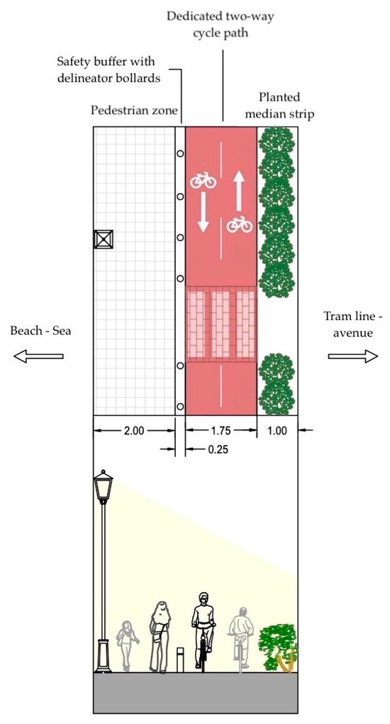
Figure 13.
Plan view and section of a random location featuring a dedicated two-way cycle track.
- Type 4
This segment of the route is approximately 3 km long and encompasses the redevelopment area of “The Ellinikon” (Figure 14).
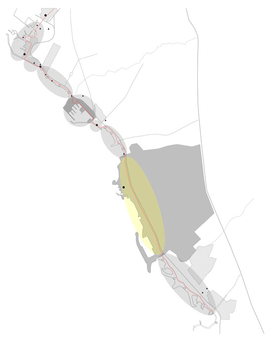
Figure 14.
Area included in Type 4.
A dedicated two-way cycle track is proposed, with the strategic use of planting to buffer motorized traffic and an enhancement of sea views, where feasible.
The proposal here centers on bi-directional cycle tracks embedded into the planned public spaces. These paths should be wide enough to accommodate high usage and should be paved with sustainable, resilient materials such as red asphalt and permeable stone. Given the project’s scale, vegetation plays a vital role. Mediterranean species—particularly those that stimulate multiple senses—should dominate the planting scheme. Herbs such as Origanum vulgare, Jasminum grandiflorum, and Lavandula angustifolia combine visual appeal, fragrance, and educational value. These species can be included in a botanical garden or in thematic park segments that encourage interactive learning and sensory engagement.
Legibility is supported by integrating clear spatial hierarchies, landmark elements, and intuitive signage. Comfort is addressed through shaded rest stops, consistent surface quality, and well-placed amenities. Adaptability is ensured through a flexible layout that allows for seasonal programming, events, and technological upgrades. The Ellinikon development should also act as a major node in the region’s cycling network, facilitating connections among residential districts, commercial centers, and coastal recreation areas. This type exemplifies how landscape architecture can integrate mobility, education, and ecological enhancement into one cohesive system.
In conclusion, in the particular design proposal, vegetation is also used for educational purposes, careful spatial layout with landmark elements, and intuitive signage, enhancing the legibility and comfort of the area.
- Type 5
The final type refers to the recently completed cycle path along the Glyfada coastline, with a total length of approximately 2.5 km (Figure 15).
Figure 15.
Area included in Type 5.
This project was implemented very recently by the municipality of Glyfada, including the completion of signage and planting along the entire length of the cycling route.
While the infrastructure is newly developed, it currently lacks environmental richness and shading, which are essential for a more immersive and comfortable cycling experience. Nevertheless, the existing foundation provides a strong base for targeted enhancements.
To improve attractiveness and comfort, supplemental planting is required. Tall tree species such as Casuarina equisetifolia, Jacaranda mimosifolia, and Pinus pinea are ideal for creating shaded canopies. These trees not only reduce thermal stress but also contribute to spatial definition. Lower-lying shrubs like Photinia fraseri and Viburnum tinus can be installed to create soft visual barriers without obstructing views toward the sea. These vegetative improvements also support biodiversity and enhance microclimatic balance.
Tactile surfacing at pedestrian crossings and nodes with high foot traffic can slow down cyclists and promote safety without impeding flow. Paving transitions—such as the integration of natural stone or ceramic tiles—should mark intersections, rest zones, and key visual access points. Seasonal adaptability can be promoted through the installation of mobile features such as vending kiosks, bicycle maintenance stations, or temporary exhibition spaces. These interventions encourage lingering and social interaction.
Legibility along this type benefits from integrated lighting systems, painted symbols, and wayfinding signs. As this segment lies at the terminus of the coastal route, it is crucial that it connects seamlessly with preceding typologies, particularly through shared design language and uninterrupted bike flows. Strengthening linkages to Glyfada’s public transport and beach areas ensures that this infrastructure serves both everyday commuters and leisure users alike.
In conclusion, in the particular design proposal, vegetation improvements aim to enhance biodiversity, whereas natural paving materials facilitate the circulation of both cyclists and pedestrians. However, all interventions focus on encouraging social interaction.
3.5. Proposals for the Entire Route
In order to achieve a unified character for the entire cycling route, it is recommended that clear and consistent signage—both horizontal (on pavement) and vertical (signposts)—be implemented along the entire length of the route to ensure the safe movement of both cyclists and pedestrians. Additionally, bicycle parking racks should be installed at regular intervals, as well as covered areas for resting and parking.
It is further proposed that the route incorporate points of service, where cyclists and pedestrians can purchase coffee or food, as well as bike shops that can provide assistance in the event of a mechanical issue or allow users to purchase missing accessories or components.
The use of differentiated surface materials at specific points—such as crossings, intersections, or zones designated for different users (e.g., pedestrians vs. cyclists)—as well as the clear physical separation of functions (e.g., through curbs, median strips, etc.) can contribute significantly to improved safety. Material selection also plays an important role in ensuring the smooth flow of movement and comfortable circulation, as factors such as surface roughness, porosity, and thermal properties can positively or negatively affect the microclimate and usability of the route.
Furthermore, the strategic use of vegetation is crucial in enhancing user comfort, particularly by providing visual and acoustic isolation from motor vehicle traffic, while simultaneously contributing to the aesthetic quality of the landscape and highlighting the natural character of the surrounding environment. Planting design, when done thoughtfully, can reinforce these qualities—especially given the existing favorable conditions along this coastal route, including sea views, horizon lines, and beachfronts.
The introduction of points of interest and parallel recreational or cultural activities (e.g., pedal boats, outdoor art exhibitions) along the route can also make it more attractive and engaging. These landmarks or focal points can additionally enhance the legibility and identity of the landscape.
Special emphasis should be placed on small-scale interventions or structures that can be strategically placed at various locations along the route to enrich the user experience and support design continuity and quality.
4. Discussion
The present study explored the potential for perceptual design principles to shape the sustainable and user-centered cycling infrastructure along the coastal corridor between Kallithea and Glyfada in Athens, Greece. The analysis revealed that when cycling routes are planned with attention to spatial perception—encompassing visual, auditory, olfactory, and tactile experiences—user satisfaction, safety, and usage rates can be significantly improved. These findings align with and build upon prior theoretical and empirical work in the fields of urban design, landscape architecture, and sustainable mobility, particularly drawing from the foundational theories of Kevin Lynch and Gordon Cullen.
At the core of this research lies the argument that functional adequacy is a necessary but insufficient condition for successful cycling infrastructure. The study supports the view that experiential and perceptual elements play a critical role in influencing mobility choices, echoing the claims made by Lynch (1960) in The Image of the City [13] and Cullen (1961) in Townscape [14]. Both authors stressed that users form mental maps and emotional relationships with urban space not merely through spatial logic but through lived, sensory experiences. This study extends their ideas into the realm of contemporary infrastructure planning, suggesting that cycling routes should be considered not only as corridors of transportation but also as narrative spaces with emotional and aesthetic resonance.
The typological classification of the coastal route—into five distinct types based on perceptual and spatial features—provides a practical design framework rooted in empirical observation. Each type was found to possess unique challenges and opportunities, with variations in exposure to traffic, landscape features, vegetation, and user density. For instance, Type 2 segments, with panoramic views and distance from motorized traffic, offered the most relaxing and sensory-rich experience, while Type 4 segments, adjacent to high-speed roads and construction zones, presented significant perceptual and physical discomfort.
This differentiation underscores the importance of context-sensitive design. Rather than imposing a uniform infrastructural model, the study advocates tailoring interventions to the specific character of each segment. This aligns with the emerging landscape approach in cycling infrastructure planning, which pays attention to the integration of ecological, aesthetic, and social dimensions into transport networks [16]. In the current study, such integration was achieved through targeted planting strategies, surface material selection, lighting design, and the incorporation of small-scale interventions such as shaded rest stops and multisensory plant palettes.
The findings also highlight the multidimensional role of vegetation—not only as a visual buffer or aesthetic enhancer but as a contributor to microclimate regulation, air quality, acoustic shielding, and sensory stimulation. This echoes principles articulated in biophilic urbanism [18] and is consistent with empirical research suggesting that green infrastructure enhances psychological well-being and encourages active transport behavior [2]. Green environments make time feel shorter and less stressful [35], and the perception of time is closely tied to emotional states [36]. This research provides an effective design solution that extends the “green time” [35] corresponding to a balanced and pleasant sensory experience through aesthetic and sensory richness that avoids overstimulation.
In particularly exposed or degraded segments of the route, such as those in Type 4, vegetation becomes an essential tool for mitigating environmental stressors and creating more humane urban conditions. It enhances the approach of many scholars specializing in cycling infrastructure design that greenery is not merely decorative; it also affects landscape quality and user experience [33].
A key implication of the study is that perceptual richness can enhance not just user enjoyment but also the functional effectiveness of infrastructure. This challenges the often-dichotomized view of aesthetics versus utility. Rather than being in opposition, these dimensions can reinforce one another. Routes that are more visually engaging, thermally comfortable, and acoustically pleasant are more likely to be used regularly [11,18]. From this perspective, designing for the senses is not merely an embellishment but a strategic component of behavioral change toward sustainable mobility.
For example, the olfactory experience of saltwater breezes near the sea was found to be pleasant and distinctive, whereas the smell of exhaust near heavy traffic zones was a deterrent. This supports the necessity of fine-grained sensory analysis in infrastructure design in landscape character assessments [37]. Similarly, auditory elements such as the sound of waves were experienced positively, whereas traffic noise was perceived negatively—even at similar decibel levels—demonstrating the influence of sound source and context on perception, as described in Russell’s (1980) [21] circumplex model of affect.
Another contribution of the research is the methodological integration of perceptual analysis with spatial mapping and typological design. This hybrid approach allows for the identification of nodes, paths, and edges not only in morphological terms but also in perceptual terms. While Lynch’s framework was historically applied through user surveys, this study adapted his elements through fieldwork and visual analysis. This divergence from traditional user-based mapping may be considered a limitation in terms of participatory validity, but it enabled a detailed, systematic evaluation of spatial characteristics across the entire corridor. Future research could expand upon this by incorporating participatory mapping and mobile sensing technologies to gather real-time user feedback.
Furthermore, the study offers a strategic model for replicability. While rooted in the specific context of the Athenian coastline, the principles and methods developed here can be applied in other urban settings—particularly those involving linear coastal or riverfront corridors. The typological framework offers a template for organizing and prioritizing interventions based on perceptual data, while the integration of multisensory plant selection and materiality provides a replicable design toolkit.
The broader implications of the study intersect with debates on the democratization of urban space and the “right to mobility” [27]. By emphasizing the perceptual quality of cycling infrastructure, the research advocates for mobility systems that are inclusive, engaging, and enriching—not just functional. This positions cycling infrastructure within a larger discourse on urban equity and environmental justice, asserting that high-quality public spaces should be accessible and appealing to all, regardless of physical ability, age, or socioeconomic status.
Looking ahead, several future research directions are suggested. First, the role of digital technologies—such as augmented reality wayfinding, sensor-based lighting, or adaptive vegetation monitoring—could be explored to further enhance the user experience and sustainability of cycling corridors. Second, longitudinal studies examining behavioral shifts following the implementation of perceptually rich infrastructure would provide empirical validation of the approach. Finally, interdisciplinary collaboration among landscape architects, urban planners, behavioral scientists, and transportation engineers will be critical in advancing the integration of perceptual design into mainstream mobility planning.
In conclusion, this study contributes to a growing body of literature that seeks to reframe cycling infrastructure not merely as a transport solution but as a cultural and spatial experience. Through the lens of perceptual design and landscape architecture, the research demonstrates that coastal cycling routes can serve as transformative urban interventions—reconnecting people with place, promoting sustainability, and reshaping the emotional geographies of the city.
5. Conclusions
This study explored the integration of perceptual landscape design with sustainable urban mobility by focusing on the planning of a coastal cycling route between the municipalities of Kallithea and Glyfada in the metropolitan area of Athens. The research began with the recognition that conventional cycling infrastructure, though often effective in technical terms, frequently neglects the experiential, emotional, and perceptual dimensions of movement through urban and natural landscapes. By adopting a landscape architecture approach and grounding the analysis in the theories of Kevin Lynch and Gordon Cullen, this study aimed to demonstrate that perception, legibility, and spatial quality can and should play a central role in cycling infrastructure design.
The study’s key contribution lies in demonstrating that cycling infrastructure is not only a functional system but also a spatial narrative, one through which users engage with place on visual, auditory, olfactory, and tactile levels. These multisensory elements significantly influence a person’s decision to cycle, especially in environments that oscillate between high-density urban zones and open, coastal stretches.
The findings underscore the value of a perceptual approach in achieving broader goals in urban mobility policy. Creating infrastructure that is perceived as safe, aesthetically pleasing, and emotionally resonant can foster more frequent and consistent cycling, which in turn contributes to reduced carbon emissions, improved public health, and greater social inclusivity. In this way, perceptual design does not compete with technical performance but enhances it, aligning user experience with sustainability objectives for a green, resilient city.
Moreover, the hybrid methodological approach combining theoretical frameworks, field observation, spatial mapping, and typological analysis offers a replicable model for cycling infrastructure planning in other urban and coastal contexts. The inclusion of landscape experiential variables such as sound, smell, material texture, and viewscapes provides planners and designers with a more holistic understanding of user needs and behaviors.
This study has certain limitations that should be acknowledged. First, the perceptual mapping and typological classification were based primarily on fieldwork and expert observation, without incorporating participatory methods such as surveys or user feedback, which could have provided deeper insights into subjective cycling experiences. Second, the analysis is case-specific, focusing exclusively on the Kallithea–Glyfada coastal corridor; while the proposed framework is replicable, its direct applicability to other geographic or cultural contexts may be limited. Third, part of the study area coincides with “The Ellinikon” redevelopment project, which remains under construction, restricting the ability to make detailed design proposals for that segment. Furthermore, the field observations were conducted within a limited temporal frame (January and August 2024), capturing seasonal differences but not longer-term variations or extreme conditions. Finally, although the study emphasizes perceptual and experiential qualities, less attention was given to technical feasibility aspects, such as construction costs, maintenance, and long-term operational challenges. These limitations highlight the need for future research that combines perceptual design with participatory input, longitudinal data, and technical assessments to ensure both user-centeredness and practical applicability.
In conclusion, this study advocates for the redefinition of cycling routes as immersive and human-centered environments rather than mere corridors of transit. By positioning landscape and perception at the core of infrastructure design, urban planners and policymakers can unlock new pathways for sustainable mobility, ecological integration, and urban livability. The proposed coastal route stands as an example of how perceptual richness, when methodically applied, can transform everyday mobility into a meaningful experience that strengthens connections among people, place, and nature.
Author Contributions
Conceptualization, M.-A.K. and A.G.; methodology, M.-A.K. and A.G.; software, M.-A.K.; validation, M.-A.K. and A.G.; investigation, M.-A.K.; resources, M.-A.K.; data curation, M.-A.K.; writing—original draft preparation, M.-A.K.; writing—review and editing, A.G.; visualization, M.-A.K.; supervision, A.G.; project administration, A.G. All authors have read and agreed to the published version of the manuscript.
Funding
This research received no external funding.
Data Availability Statement
The datasets generated and analyzed during the current study are available from the corresponding author on reasonable request.
Conflicts of Interest
The authors declare no conflicts of interest.
References
- Gehl, J. Cities for People; Island Press: Washington, DC, USA, 2010. [Google Scholar]
- Bedimo-Rung, A.L.; Mowen, A.J.; Cohen, D.A. The significance of parks to physical activity and public health: A conceptual model. Am. J. Prev. Med. 2005, 28 (Suppl. S2), 159–168. [Google Scholar] [CrossRef] [PubMed]
- Hartig, T.; Mitchell, R.; de Vries, S.; Frumkin, H. Nature and Health. Annu. Rev. Public Health 2014, 35, 207–228. [Google Scholar] [CrossRef] [PubMed]
- Zijlema, W.L.; Palencia, I.A.; Triguero-Mas, M.; Gidlow, C.; Maas, J.; Kruize, H.; Andrusaityte, S.; Grazuleviciene, R.; Nieuwenhuijsen, M.J. Active commuting through natural environments is associated with better mental health: Results from the PHENOTYPE project. Environ. Int. 2018, 121 Pt 1, 721–727. [Google Scholar] [CrossRef] [PubMed]
- Nawrath, M.; Kowarik, I.; Fischer, L.K. The influence of green streets on cycling behavior in European cities. Landsc. Urban Plan. 2019, 190, 103598. [Google Scholar] [CrossRef]
- Black, P.; Street, E. The power of perceptions: Exploring the role of urban design in cycling behaviours and healthy ageing. Transp. Res. Procedia 2014, 4, 68–79. [Google Scholar] [CrossRef]
- Owen, N.; Humpel, N.; Leslie, E.; Bauman, A.; Sallis, J.F. Understanding environmental influences on walking; Review and research agenda. Am. J. Prev. Med. 2004, 27, 67–76. [Google Scholar] [CrossRef] [PubMed]
- Conti, A.; Ruggeri, D.; Bartolomei, L. Soft infrastructure as landscape—A methodology for the assessment and improvement of the user experience of soft mobility. Transp. Res. Procedia 2016, 14, 2396–2405. [Google Scholar] [CrossRef][Green Version]
- Commission of the European Communities. Cycling: The Way Ahead for Towns and Cities. Available online: https://www.openbook.gr/i-poli-paei-mprosta-me-to-podilato (accessed on 1 June 2025). (In Greek).
- Hull, A.; O’Holleran, C. Bicycle infrastructure: Can good design encourage cycling? Urban Plan. Transp. Res. 2014, 2, 369–406. [Google Scholar] [CrossRef]
- Liu, G.; Krishnamurthy, S.; Wesemael, P. Conceptualizing cycling experience in urban design research: A systematic literature review. Appl. Mobilities 2018, 6, 92–108. [Google Scholar] [CrossRef]
- Vlastos, T.; Milakis, D.; Athanasopoulos, K. Bicycle in 17 Greek Cities; ΥΠΕΠΘ/ΟΕΔΒ: Athens, Greece, 2004. [Google Scholar]
- Lynch, K. The Image of the City; MIT Press: Cambridge, MA, USA, 1960. [Google Scholar]
- Cullen, G. The Concise Townscape; Architectural Press: Oxford, UK, 1961. [Google Scholar]
- Stephens, A. Improving the Aesthetic and Other Experiential Design Aspects of Bicycle Paths in Western Australia. Master’s Thesis, Edith Cowan University, Joondalup, Australia, 2010. Available online: https://ro.ecu.edu.au/theses/874 (accessed on 4 June 2025). (In English).
- Klaveren, R. Naturally Steering Towards a Landscape Approach on Cycling Infrastructure. Master’s Thesis, Radboud University, Nijmegen, The Netherlands, 2023. Available online: https://theses.ubn.ru.nl/items/446e8294-5a87-46c5-bd69-cbfd55af1a23/full (accessed on 30 May 2025). (In English).
- Etminani-Ghasrodashti, R.; Paydar, M.; Ardeshiri, A. Recreational cycling in a coastal city: Investigating lifestyle, attitudes and built environment in cycling behavior. Sustain. Cities Soc. 2018, 39, 241–251. [Google Scholar] [CrossRef]
- Lee, C.; Moudon, A.V. Neighbourhood design and physical activity. Build. Res. Inf. 2008, 36, 395–411. [Google Scholar] [CrossRef]
- Li, Z.; Wang, W.; Liu, P.; Ragland, D.R. Physical environments influencing bicyclists’ perception of comfort on separated and on-street bicycle facilities. Transp. Res. Part D-Transp. Environ. 2012, 17, 256–261. [Google Scholar] [CrossRef]
- Fleming, S. Cycle Space: Architecture & Urban Design in the Age of the Bicycle; nai010 publishers: Rotterdam, The Netherlands, 2012. [Google Scholar]
- Russell, J.A. A circumplex model of affect. J. Personal. Soc. Psychol. 1980, 39, 1161–1178. [Google Scholar] [CrossRef]
- Shafer, E.L.; Hamilton, J.F.; Schmidt, E.A. Natural landscape preferences: A predictive model. J. Leis. Res. 1969, 1, 1–19. [Google Scholar] [CrossRef]
- Beatley, T. Biophilic Cities: Integrating Nature into Urban Design and Planning. Island Press: Washington, DC, USA, 2011. [Google Scholar]
- Mostafavi, M.; Doherty, G. Ecological Urbanism; Lars Muller Publishers: Los Angeles, CA, USA, 2010. [Google Scholar]
- Newell, R.; Dale, A.; Lister, N.-M. An integrated climate-biodiversity framework to improve planning and pol-icy: An application to wildlife crossings and landscape connectivity. Ecol. Soc. 2022, 27, 23. [Google Scholar] [CrossRef]
- Mehta, V. The Street: A Quintessential Social Public Space; Routledge: London, UK, 2013. [Google Scholar]
- United Nations. Our Common Future: Report of the World Commission on Environment and Development. Available online: https://www.are.admin.ch/are/en/home/media/publications/sustainable-development/brundtland-report.html (accessed on 2 June 2025). (In English).
- Hellenic Statistical Authority. Available online: https://www.statistics.gr/en/home (accessed on 4 June 2025).
- Jones, P. Sensory indiscipline and affect: A study of commuter cycling. Soc. Cult. Geogr. 2012, 13, 645–658. [Google Scholar] [CrossRef]
- Jungnickel, K.; Aldred, R. Cycling’s Sensory Strategies: How Cyclists Mediate their Exposure to the Urban Environment. Mobilities 2014, 9, 238–255. [Google Scholar]
- Van Duppen, J.; Spierings, B. Retracing trajectories: The embodied experience of cycling, urban sensescapes and the commute between ‘neighbourhood’ and ‘city’ in Utrecht, NL. J. Transp. Geogr. 2013, 30, 234–243. [Google Scholar] [CrossRef]
- Zhang, R.; Te Brommelstroet, M.; Nikolaeva, A. Cycling subjective experience: A conceptual framework and methods review. Transp. Res. Part F Traffic Psychol. Behav. 2024, 101, 142–159. Available online: https://www.sciencedirect.com/journal/transportation-research-part-f-traffic-psychology-and-behaviour/vol/101/suppl/C (accessed on 25 May 2025). (In English). [CrossRef]
- Vlastos, T.; Birbili, T. Creating Bicycle-Friendly Cities. Elements of Aesthetics and Construction—The First Examples in Greece and Cyprus; E.U. Directorate-General for Environment, Development Agency of the Municipality of Athens, Regulatory Plan and Environmental Protection Organization of Athens: Athens, Greece, 2011. (In Greek) [Google Scholar]
- Folke, C.; Carpenter, S.R.; Walker, B.; Scheffer, M.; Chapin, T.; Rockström, J. Resilience thinking: Integrating resilience, adaptability and transformability. Ecol. Soc. 2010, 15, 20. [Google Scholar] [CrossRef]
- Karter, O.; Groenendijk, L. Onderzoek Reistijdbeleving Fietsers. Goudappel Cofeng. Available online: https://www.goudappel.nl/sites/default/files/2022-02/onderzoek-reistijdbeleving-fietsers.pdf (accessed on 3 May 2025). (In English).
- Van Hagen, M. Waiting Experience at Train Stations. Doctoral Dissertation. Available online: https://ris.utwente.nl/ws/portalfiles/portal/6066520/thesis_M_van_Hagen.pdf (accessed on 2 May 2024). (In English).
- Swanwick, C. Landscape Character Assessment: Guidance for England and Scotland; Natural England and Scottish Natural Heritage: York, UK, 2002. [Google Scholar]


Disclaimer/Publisher’s Note: The statements, opinions and data contained in all publications are solely those of the individual author(s) and contributor(s) and not of MDPI and/or the editor(s). MDPI and/or the editor(s) disclaim responsibility for any injury to people or property resulting from any ideas, methods, instructions or products referred to in the content. |
© 2025 by the authors. Licensee MDPI, Basel, Switzerland. This article is an open access article distributed under the terms and conditions of the Creative Commons Attribution (CC BY) license (https://creativecommons.org/licenses/by/4.0/).