Abstract
Geoarchaeological work and excavations of the Helike Project over the last 30 years in the Helike coastal plain, Gulf of Corinth, have yielded abundant evidence on ancient settlements, as well as the surrounding landscape and environmental changes that resulted from geological phenomena and catastrophic events. The research methods applied by the Helike Project followed a multidisciplinary approach, including combined archaeological excavations and palaeoseismological trenching, geophysical prospection, archaeometric, environmental, and soil micromorphology analyses, and computer-based landscape modelling. A wealth of settlement remains that were unearthed across the plain, ranging in date from the Early Helladic period (3rd millennium BC) to the Late Antiquity (5th century AD), indicates that the ancient inhabitants of the area chose to always resettle in the area by adjusting their ways of living to the geomorphology and natural hazards, prevailing each time. Our results show that disasters in the area increased between the Geometric and Roman times due to severe earthquakes that occurred approximately every 300 years. In particular, archaeological and geological finds recovered from the Late Classical–Hellenistic Helike settlement, which was revived in the western part of the plain shortly after the disastrous 373 BC earthquake, have enriched our knowledge regarding the historical seismicity of the region and past human–environment relationships.
1. Introduction
Helike, the principal city of ancient Achaea, located on the southwest shore of the Gulf of Corinth, was founded in the Bronze Age and was severely damaged by an earthquake and tsunami in 373 BC. This remarkable catastrophic event made a great impression on the ancient world. It was reported by many ancient authors, contemporary and of later dates, down to the middle Byzantine times [1,2,3]. The area of Helike is one of the most seismically active regions in Greece [4,5,6,7], bound to the south by the Helike Fault and to the north by the Aigion Fault.
Because Helike was reportedly submerged by the 373 BC earthquake, previous efforts to locate its site were concentrated in the sea, and their results were inconclusive [8]. To resolve whether the ancient city lay in the sea or on land, the Helike Project launched a long-term multidisciplinary research program in 1988. First, a systematic underwater survey was conducted southeast of Aigion using a side-scan and sub-bottom sonar (Figure 1a). The results showed no ruins of an ancient city underwater, and thus, research was redirected to the adjacent broad, coastal plain between the Selinous (west) and Vouraikos (east) Rivers using extensive borehole drilling and geophysical exploration [9,10] (Figure 1a). Since 2000, the systematic excavations of the Helike Project have brought to light architectural remains dating from the Early Bronze Age (EBA), the Mycenaean, Geometric, Classical, Hellenistic, Roman, and Late Byzantine periods [11,12,13].
Geoarchaeological studies of the finds recovered from the excavations suggested evidence of a destructive mudflow that followed the 373 BC earthquake [7] and a lagoon formation in the Early Helladic and Classical Helike sites [9,14]. Further, applications of soil micromorphology applied to the Late ClassicalHellenistic Helike site showed evidence of earthquakes and other geological hazards in soil and sediment in a direct stratigraphical association with the architecture of the site [15].
Digital elevation models (DEMs) have been used in the Helike region to model the terrain’s characteristics, focusing on landscape models of the Early Helladic, Classical, Hellenistic, and Roman periods. The continuous occupation of the landscape is connected to a relationship between the sea and land, manifested through marine transgressions, earthquakes, tsunamis, tectonic uplift, sediment deposition, and delta subsidence [16]. These dynamic models allow us to enter the story of the Helike landscape at different temporal levels and scales, ranging from micro-faunal identification and absolute dating to large-scale spatial considerations, thus strengthening our archaeological interpretation of long-term trends, sequences, and changes. Archaeological evidence from the Helike Project excavations provides a web of interdisciplinary data that shows how past societies interacted with the environment, thus contributing to our understanding of the destruction/resilience system that can be useful for a sustainable future [17]. The collected data cover habitation in the area over a long chronological timeframe, ranging from the Early Bronze Age to the Late Antiquity. Resilience is the intrinsic ability of an ecosystem or a society to adjust its functioning prior to, during, or following environmental changes or natural disasters so that it can maintain its status [18].
In this paper, we used the results of the Helike Project’s geoarchaeological work and excavations to produce an accurate timeline, which can reflect data of seismic history along the Helike Fault spanning almost three millennia. These data also offer reliable calibration dates for palaeoseismologically defined earthquakes. Finally, we provide tangible evidence of societal reactions to natural disasters, people’s adjustments to environmental changes, and habitation patterns in earthquake-prone areas.
2. Geology and Seismology of the Helike Area
The Gulf of Corinth, located in central Greece, represents an active intra-continental rift zone that runs nearly perpendicular to the Greek orogenic belt. The rift’s current geological activity is shown by prominently exposed fault scarps, faulted colluvial wedges, raised shorelines, and earthquake environmental effects, including landslides on land and underwater [7,19,20,21,22,23] (Figure 1).
Dating of uplifted syn-rift sediments in northern Peloponnese indicates that the rift began developing approximately 4 million years ago, progressing from east to west and from south to north [21,24,25,26,27,28]. From the lower Pleistocene period (1.8–1.5 Ma) onward, the deformation and sediment deposition within the rift have shifted northward alongside an increased extension rate [20,21,22,23,24,25,26,27,28,29].
The rift experiences an almost north/south-oriented extension, as indicated by both geodetic and fault-slip analyses [27,28,30,31]. Throughout the rift, the orientation of the fault array changes progressively from ENE to WNW as one moves from east to west [7,32,33,34,35].
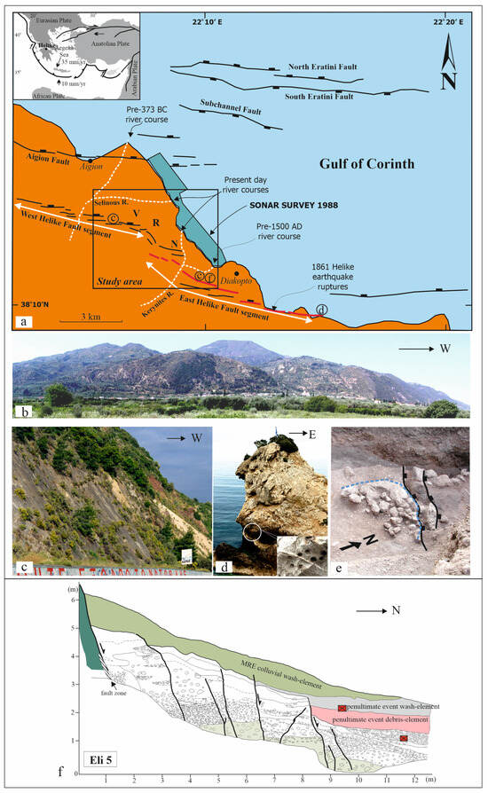
Figure 1.
(a) Simplified structural map of the broader study area, presenting the major active faults in proximity with the Helike site, shown in the black rectangle (the map is modified after [7,33]. The inset shows the geotectonic setting of the study area in the Eastern Mediterranean and Helike’s location. Note: R = Rizomylos, N = Nikolaiika, and V = Valimitika indicate the main archaeological sites in the Helike region. (b) Panoramic view of the central part of the Helike Fault scarp. This photo is taken looking south, and the width of the photo is approximately 7.5 km. (c) Details of the exposed fault plane of the HF. This photo is taken looking west, and the height of the outcrop is 30 m. For the location of the photo, see (a). (d) Overview (view to the east) showing notched Mesozoic limestones that formed along the Helike Fault plane; for location, see (a). The inset shows the L. lithophaga hole entrances in limestone bedrock. For the location of the photo, see (a). (e) Photograph showing a semicircular pile of stones, outlined by a dashed blue line, excavated within the T13 trench. The thick black lines mark surface ruptures of the ancient remains during the 5th century AD earthquake (photo is modified after [36]). For the location of the photo, see (a). (f) Eli5 trench log and its interpretation in terms of palaeoseismic stratigraphic units and events across the HF (the log is modified after [37]). The red boxes represent charcoal-dated samples; for dates, see Figure 2 and Table 1. MRE = most recent event. For the location of the photo, see (a).

Table 1.
Radiocarbon (14C) and thermoluminescence (TL) ages of samples recovered from Eli3, T13, Eli4, Eli5 and EEFT1A palaeoseismological trenches.
Historical earthquakes have been documented in the Gulf of Corinth rift [4,5,38,39] (Figure 1a). In particular, the seismic activity in the western Corinth rift, where the ancient city of Helike lies, is characterized by significant historical earthquakes and short-in-time swarms of clustered seismic events that lasted for one to two years [40,41,42]. The region between the Diakopton and Rion-Antirrion straits, according to seismic reflection studies and onshore surveys, is traversed by a complicated network of both offshore and onshore faults [7,33,43,44,45,46,47] (see Figure 1a). These investigations have revealed a complex basin structure with notable along-strike variations that are linked to alterations in the underlying basement fabric. Specifically, the deformation concentrates on normal faults dipping to the north, which deform the southern coast and cut through the offshore area of the rift. Evaluation of data from several palaeoseismological trenches has shown that the coastal faults of the northern Peloponnese exhibit high slip rates, varying from 0.3 to 11 mm per year [7,33,48,49]. Figure 1f shows an example of a palaeoseismological trench excavated in the Helike area.
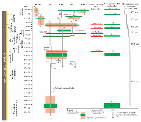
Figure 2.
Chronogram of palaeoearthquakes, recognized in the EET1A [44], Eli3 and T13 [33,36], and Eli4 and Eli5 [37] trenches excavated across the HF, based on 14C and archaeological dating. For details, see the text. The recurrence interval of the earthquakes is defined based on the historical data for MRE (most recent event) and PE (penultimate event), and the palaeoearthquakes correlated with the archaeological evidence for E3–E6 events.
2.1. The Seismic History of the Helike Fault
Understanding a fault’s seismic history and its connectivity with nearby faults is important for defining two parameters of forthcoming earthquakes, i.e., their magnitude and time-frequency. In our case study, these two parameters are also critical for understanding the history of the settlement, which evolved in this central part of the Gulf of Corinth over a long period. To define these critical parameters, we have applied trench excavation using combined techniques of archaeology and palaeoseismology. The data acquired concern the dating and the magnitude of earthquakes and their environmental impact.
The Helike Fault (HF) controls the evolution of the Helike delta plain and the environmental changes that occurred in the area, e.g., a change in river course through time (Figure 1a). This fault has a clear surface trace (Figure 1b,c) that crosscuts a series of pre-earthquake landforms, and its steep fault plane offsets recent deposits. It is 23 km long, divided into two prominent segments (Figure 1a). Its trace is slightly irregular and separated from adjacent normal faults (Figure 1a). The HF is a crustal-penetrating fault, has a 600 m minimum cumulative throw, and separates a mountain range footwall block from an adjacent alluvial plain where three coalescence deltas have formed (Figure 1b). The HF dips consistently from 55–60° north (Figure 1c), and on a mesoscopic scale, it is accompanied by secondary synthetic normal faults. Similarly, like many normal faults, it decreases its dip with increasing depth (listric geometry) and sole into a north-dipping low-angle fault [40,50]. This low-angle fault at depth coalesces with many higher-angle normal faults in the Gulf of Corinth [40].
2.2. Palaeoseismological Studies of the Helike Fault (HF)
Since the HF controls the landscape and the shorelines of the western Gulf of Corinth, it naturally affects ancient settlements developed on the Helike Delta (Figure 1). The slip rate of the fault ranges from 0.3 to 13.7 mm/yr, depending on the time scale and method of observation [39,40,51,52,53,54,55,56,57]. For this study, the slip rate of the fault is recalculated based on a series of palaeoseismological trenches [33,36,37]. In total, 13 single-slot California-type trenches were excavated across the fault scarp, which is east of the Kerynites River. Their stratigraphy is dominated by coarse-grain clastic materials (Figure 1f), which cover a period of approximately the entire Holocene (Figure 2). In particular, the stratigraphy of the trenches is controlled by three splays of the HF, and within their tectonostratigraphy, seven fault-controlled colluvial wedges were noted [33,36,37] (Figure 1f and Figure 2).
Among the 13 trenches excavated, are reviewed in this study the EET1A [54,55,56,57], Eli3 and T13 [33,36], and Eli4 and Eli5 [37]. These five trenches include all previously mentioned colluvial wedges, dated by 20 14C-calibrated samples with two standard deviations of uncertainty. Another criterion for their selection is based on the archaeological finds unearthed within their limits (Figure 1e). T13 reached a maximum depth of 5.5 m and contained a Roman tomb offset by a past earthquake surface rupture. In addition, a tile-covered Roman grave was discovered in Eli3. Notably, the trench T13 stratigraphy expands approximately over the entire Holocene, and Eli3 shows the best-preserved colluvial wedge of the 1861 earthquake [33]. In this colluvial wedge, pottery sherds of the Ottoman period were found. Eli4, Eli5, and EET1A preserved a clear tectonostratigraphy of the last four events hosted along the Helike Fault. These events are annotated as MRE, PE, E3, and E4 (Figure 2).
To estimate the age of the earlier earthquake events (E4–E7), dating was based on palaeoseismology, although with significant uncertainty (Figure 2, Table 1). In particular, the E7 event is recognised in only one trench. In the T13 trench, E7 is constrained based on the dates of two samples, T13-1 and T13-2 (Table 1). Lacking further palaeoseismological data, we considered that the probable age of the E7 is close to the middle of this period, at about 7.8 ± 2.4 ka BC. Event six (E6) is again poorly dated at about 2.4 ± 1.4 ka BC, based on two 14C-dated samples from trench T13 [36] (Figure 2). However, this event was dated ca. 2100 BC during archaeological excavations at the Early Bronze Age Helike settlement (see next Section 3.1). Thus, we adopted the archaeologically determined age for this event. Similarly, the E5–E3 events are identified based on 14C-calibrated data with archaeological dating (Figure 2 and Figure 3, Table 1). Therefore, seismic events dated via archaeological data obtain accurate age estimates in contrast with ages constrained only by 14C-calibrated data. The archaeometric error usually ranges between 300–615 years (Figure 3). Accordingly, we can constrain the recurrence interval and the true slip rate (SRT) between events (Figure 2 and Figure 3).
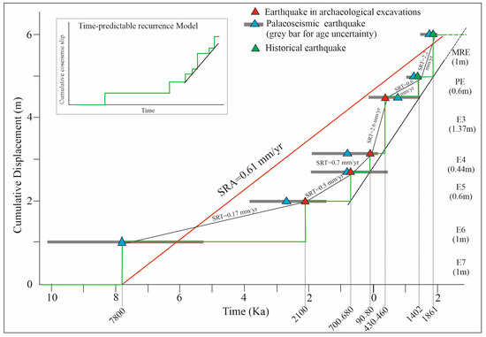
Figure 3.
Slip history diagram of the HF. Geological records extend from today to 9.8 ka. The red line indicates the apparent slip rate (SRA), and the black lines indicate the true slip rate (SRT) defined by closed seismic cycles. The inset shows the proposed earthquake predicted model adopted from the published literature (for discussion, see text).
Finally, based on the palaeoseismological and archaeological data of the excavation of these five trenches and their dating, we compiled a new complete seismic history of the HF. This timeline resolves parameters such as the slip per event, the apparent slip rate (SRA), and the true slip rate (SRT), defined by six closed seismic cycles (Figure 3). A series of historical earthquakes (1861, 1402, 1147) have been documented and could correspond particularly with the penultimate event (PE) [4,5,38,39]. Among them, we have more than one candidate event, but we lack the exact geographical limits, and sometimes we have only contradicting age determinations. Two notably harmful and thoroughly recorded earthquakes occurred in 1147 and 1402 AD, respectively. Both had devastating consequences for the town of Galaxidi, located opposite our study area, as well as for the entire region around Helike between Xylokastron (east) and Aigion (west). We suggest that the Helike Fault most probably hosted the 1402 earthquake. The MRE is a well-documented event in our study area, which occurred in 1861 in the western Gulf of Corinth [4,38,39,40,58].
Based on the new data, we recalculated the apparent slip rate of the fault as appeared in the published papers by [33,36] at an increased value, from 0.5 mm/yr to 0.61 mm/yr. In addition, the SRT between events ranges between 0.17 to 2.6 mm/yr. However, as the SRT = 0.17 mm/yr for the event E7 (Figure 3) was recognised in only one trench, and because archaeological data for this period are missing, we can exclude E7 from our calculations because its time constraint is uncertain. Then, the range of the SRTs for all other events shows a bimodal distribution, with a low SRT ranging from 0.5 to 0.7 mm/yr. Moreover, a high SRT ranged from 2.2 to 2.6 mm/yr. Accordingly, a time-predictable recurrence model for the Helike Fault is proposed based on the last five seismic cycles. The maximum anticipated earthquake magnitudes reach approximately 6.7 [7,33,36].
3. Settlement and Mobility in Helike: The Archaeological Evidence
3.1. Occupation in Prehistoric Times: The Early Helladic and the Mycenaean Sites
Archaeological data from the Helike Project excavations, so far, indicate that the earliest Helike settlement, dated to the Early Bronze Age (EBA), was built in the central part of the Helike Plain between the Selinous and Kerynites Rivers (Figure 1a, R). At this location, in the area of modern Rizomylos, excavations brought to light the impressive remains of a coastal proto-urban settlement built only a few hundred metres from the sea on the seaward side of an intermittent lagoon that has existed in this part of the plain since the Late Neolithic period [9]. The settlement shows organised town planning, consisting of large rectilinear buildings with spacious rooms built across cobbled streets and open paved areas. Of particular interest among the buildings is a construction of the type known as a “corridor house”, suggesting the presence of a central administration in control of the settlement [11].
The enormous amounts of pottery collected from the excavated buildings include many complete vases, a notable number of fully restored vessels, and a significant number of intact pots corresponding to the Early Helladic (EH) II and III periods, thus dating the settlement to ca. 2500–2200/2100 BC [11,59]. An even earlier occupation of the site, going back possibly to the Neolithic period, is suggested by the 14C dating and recovered ceramics from the boreholes drilled to greater depths underlying the excavated EH remains [11].
Archaeological evidence and palaeoenvironmental studies of the sediment samples from the EH buildings suggest that the settlement was destroyed ca. 2100 BC by an earthquake, most probably accompanied by extensive fire, and submerged in a coastal lagoon under sediments containing a mixture of freshwater, brackish, and marine microfossils [60]. The lagoon later silted over, thus keeping the settlement protected from any subsequent human interventions. Today, the settlement is buried 3–5.5 m below the surface and 1 km from the contemporary shoreline.
In the following Late Bronze Age (LBA), the Mycenaean habitation site of Helike is found about 1.5 km to the southeast of the EBA settlement, in the eastern part of the Helike Plain near the Kerynites River in the modern village of Nikolaiika [61] (Figure 1a, N).
3.2. Occupation in Historical Times: The Geometric/Archaic Sites
In the same general area of modern Nikolaiika, our excavations uncovered at a depth of 2–3 m below the surface, architectural remains of well-built walls of a large building dated on the basis of rich associated pottery to the Geometric period.
The geological data acquired from the excavations at the Geometric Helike site are of particular interest. Along the southern part of the excavated Geometric walls, a segment of the active HF was revealed, crossing the excavation and shaping its stratigraphy into a footwall and hanging wall blocks. In the tectonostratigraphy of the excavation (Figure 4), it was possible to identify the occurrence of an entirely unknown Geometric earthquake, ca. 700–680 BC, of a magnitude estimated at 6.3R. The catastrophic event coincided with the destruction and abandonment of the site, which was consequently buried under a succession of torrential and river-borne sediment.
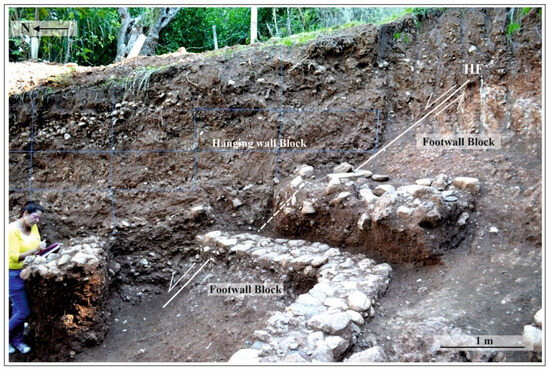
Figure 4.
Archaeological excavation showing Geometric period architectural remains and destruction layer offset by the Helike Fault (HF). The dashed line shows the proposed continuation of the fault under the destruction layer. The footwall block includes well-cemented conglomerates, and the hanging wall block is composed of successive colluvial material.
It is noted that, at this location, a mudbrick superstructure based on a tall stone footing was chosen by ancient builders, a technique particularly effective in areas susceptible to mudflows and floods. Also, the use of the natural terrace of solidified conglomerate substratum on the HF as a foundation for the construction suggests that they possessed the technical know-how in securing the structure in terms of statics.
3.3. The Classical and Hellenistic Sites
Based on the archaeological evidence from our excavations in the Helike Plain so far, it appears that the Classical Helike settlement occupied the area between Nikolaiika (east) and Rizomylos-Eliki (west) (Figure 1, N-R). In other words, following the Geometric/Archaic period, the settlement expanded toward the central and western parts of the plain. In particular, the discovery of ruined Classical walls and a Classical destruction layer in Rizomylos is noticeable. Remains of destroyed Classical walls of the 4th century BC, found buried under lagoonal sediments at a depth of 3 m below the surface in a location about 150 m southwest of the earlier EH settlement in Rizomylos, show evidence of a possible wave action (tsunami), perhaps related to the 373 BC earthquake [2].
In the second location, about 250 m south–southeast of the EH settlement, a thick Classical destruction layer of big cobblestones from destroyed stone walls, large clay roof tiles, and a good deal of pottery was excavated at a depth of about 2 m below the ground’s surface. The strong presence of Bithynia fossils in the strata covering the excavated destruction layer suggests the formation of a lacustrine environment at this location, postdating its destruction. Geological data of a purely terrestrial environment from a borehole, drilled a short distance from the archaeological excavation, suggest that this location lies at the transitory margin from an ephemeral lake or its coastal marshy section to an inland environment. These data seem to agree with the reported location of Helike at a distance of 12 stadia (about 2 km) from the sea [2].
Only a few decades after the 373 BC seismic event, a new settlement re-emerged in the western part of the Helike Plain, in modern Eliki-Valimitika (Figure 1a, V). Excavations by our team in this region brought to light a good number of Late Classical–Hellenistic buildings, including the well-preserved remains of a large-scale textile workshop, suggesting that Helike soon recovered from the earthquake’s fatal blow and became a flourishing town in the Hellenistic period [12,13]. The advantageous location of the settlement on the southwest shore of the Gulf of Corinth favoured maritime travelling and trade since prehistoric times, as the excavation finds from the Helike EBA settlement suggest [11]. In particular, the Hellenistic textile dye works in Helike, the only workshop positioned near the sea among its contemporaries around the Gulf of Corinth, played a key role in the commerce and economy of the region, thus demonstrating the importance of coastal locations in textile manufacturing and cultural exchange.
It is worth mentioning that the preference shown by the Helike builders in the earliest phase of the construction, dated to the second half of the 4th century BC, for a polygonal mode of masonry, may well be related to a desire for a more solid and sturdy structure following the catastrophic experience of the 373 BC earthquake a few decades ago.
3.4. Occupation in Later Times: The Roman Site
Following the destruction of the Hellenistic settlement by another earthquake ca. 90/80 BC, the people of Helike moved further back east, where the pre-373 BC earthquake habitation sites were located (Figure 1a, R and N). The Roman settlement, the immediate successor to the Hellenistic one, soon expanded and developed toward the east along and to the south of the central Roman road (Figure 5a), crossing the Helike Plain near the coastline [10].
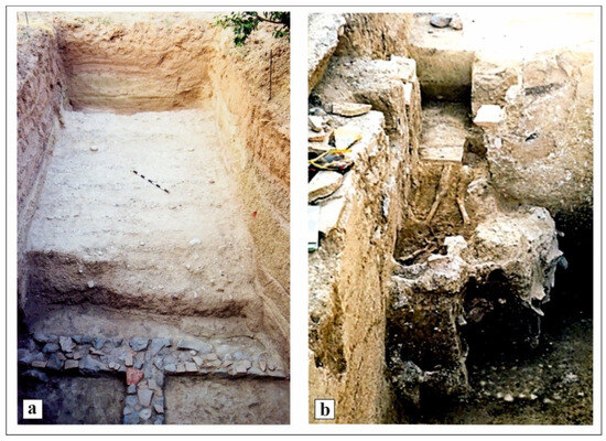
Figure 5.
(a) Segment of the Roman road and Hellenistic architectural remains of walls excavated in the western Helike Plain. (b) Skeletal remains of a man in an extended position, found under the collapsed ruins of a Roman building in Nikolaiika.
The settlement enjoyed a long life from the late 1st century BC to about the middle of the 5th century AD. Here, a successor installation of the abandoned Hellenistic dyeing workshops was found, which continued to operate into the Roman period. Thus, the skill for crafts seems to be a diachronic feature of the Helike culture, not interrupted by a natural catastrophe that occurred, but transferred and continued within the new settlement site by the surviving population.
Similarly to the previous Helike settlements, the Roman site was devastated by a strong earthquake in the first half of the 5th century AD, as indicated by our excavation data [62]. In this case, however, the disaster left us with tragic evidence of the violent death of a man and his animal (Figure 5b), who were found buried under the ruins of one of the destroyed buildings [62,63].
4. The Dynamic Landscape of Helike
A school of thought, advocated by Ingold [64] and others, argues that a landscape is cultural and temporal and that temporality is imprinted in the patterns of dwellings throughout the ages. People’s engagement with the landscape draws its unique significance through an array of related features that only have meaning in people’s minds. The archaeologist’s task is to uncover such meanings, where each object in the landscape becomes a clue to meaning, which is fundamentally temporal.
This view is not dissimilar to and, we believe, is inspired by key thinkers across different philosophical traditions. For example, Heraκleitos (c. 535–475 BC) put forward the idea that “you cannot step into the same river twice”, which highlights how landscapes are always in flux and shaped by time, as discussed by Patrick [65]. More recently, Lock [66] emphasised how humans are embedded in time and place. He defined ‘dwelling’ as living authentically in harmony with, and shaping, the landscape rather than simply as something to exploit.
Ingold [64] argues for a rigorous landscape theory that can be investigated and demonstrated through GIS technologies. Because GIS is essentially quantitative, we need to understand the mismatch between the study of people and landscapes, which is essentially qualitative. The central argument is how this relationship can be modelled within GIS; what can we hope to achieve through the digital representation of place, space, and their temporal meaning?
Polla and Verhangen [67] focused on theories about the way and reason why people moved in the landscape. They used computer-based modelling approaches, experimenting with the various parameters involved, such as in Lock et al. [68], where all assumptions are laid out in detail, allowing for different scenarios to be explored and compared to real-world outcomes. Computer modelling is, thus, a heuristic approach that aids the development of theory and interpretation through hypothesis testing.
This section focuses on movement in the landscape in the region of Ancient Helike, where landscapes are not just physical spaces but ones that hold deep emotional, cultural, and historical meanings. As Heidegger [69] has emphasised, dwelling is a fundamental way humans exist. People do not just inhabit spaces; they develop a sense of belonging so that, even after disasters, their identity remains strongly tied to that place [70,71,72,73]. Returning may indicate restoration of identity and continuity, as there is a sense of home even if the physical environment has changed. As such, the Helike region was constantly reoccupied after each disaster from the Early Helladic to the Late Antiquity.
Computer-Based Modelling of the Helike Landscape
Digital elevation models (DEMs) are widely used in geographic information systems (GIS), remote sensing, and topographic analysis to model terrain characteristics. A methodology for modelling ancient landscapes has been developed by one of us (MK), whereby a representation of the current landscape is dynamically modified according to the following five variables: the rates of sediment deposition, sea level rise, and tectonic uplift, together with earthquake-related events of pulse tectonic uplift and subsidence. The simulation runs backwards in time from a present landscape DEM.
Focusing on the green height profile in Figure 6, there are repeated patterns where all elevations increase at a certain rate (tectonic uplift, sea level rise, and sediment deposition), followed by inflexion points caused by strong earthquakes with combined pulse tectonic uplift and subsidence (Figure 6). Strong earthquakes are repeated six times, as shown in the Early Helladic (2100 BC), Geometric (700–680 BC), Classical (373 BC), Late Hellenistic (90–80 BC), and Roman (mid-5th AD) periods, and more recently, in the 19th century (1861). These events have also been verified by geological and archaeological evidence, with some reported by historical records.
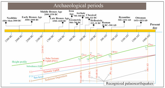
Figure 6.
Depiction of repeated patterns of elevation trajectories in the Helike landscape, in a qualitative way.
The simulations reported in this section are focused on the events of 2100 BC and 373 BC, as Soter [52] estimates an average sediment deposition of 16.8 m over the past 7000 years. The deposition process is related to fluctuations in sea level rise and tectonic uplift, with periods of accelerated sediment accumulation followed by steady isostatic adjustments. Furthermore, variations in deposition rates across the Helike Plain are probably largely driven by differences in terrain characteristics and local elevation. Specifically, archaeological data from the Early Helladic site suggest a deposition rate of approximately 1 m per thousand years (m/kyr) over the last 4100 years.
Concerning the sea level rise, Soter [52]’s findings reveal an average rate of 0.5 m per thousand years (m/kyr) over the past 5000 years for the periods under consideration. For example, for a simulation dated to 373 BC, the estimated sea level in the Gulf of Corinth would have been 1.19 m lower than present, based on the calculation 0.5 × 2373 = 1.19 m. Concerning tectonic uplift and subsidence, these must be estimated based on the sea level, which depends on the accurate dating of marine organisms. Radiocarbon dating requires calibration due to the reservoir effect, where deep-water mixing causes marine samples to appear older than they are. In the Gulf of Corinth, Soter [52] estimated a local correction of 380 years based on radiocarbon dating for marine samples in the Helike Delta to account for carbon depletion from surrounding limestone.
By plotting the calibrated shoreline ages against elevation, Soter [52] demonstrated that the shoreline was approximately 20 m lower around 9000 BP than its present level. Additionally, two significant discontinuities were identified. The first discontinuity suggests a pulse uplift of 6–7 m in the earthquake of 2100 BC, while the second may correspond to the 373 BC earthquake, during which an uplift of approximately 2 m occurred. Furthermore, the data provide preliminary evidence that the 1861 AD earthquake resulted in an uplift of approximately 1 m.
Taking these factors into account, the analysis estimates subsidence in the range of 4 to 9 m for the earthquake of 373 BC, and the assumed co-seismic subsidence is 4.5 m [52]. This aligns with the suggestion of at least 3 m of subsidence and is further supported by evidence of significant shoreline submergence, likely caused by plain tilting, soil liquefaction, and submarine landslides, as observed in the 1861 AD earthquake.
The quantification discussed above can be incorporated into a general equation to calculate time-dependent heights of every single point in a DEM model as follows:
where Ht1 is the DEM height at time t1, Ht0 is the height at the start time, St1 is the pulse subsidence, Ut1 is pulse tectonic uplift, t is the time, and RS, RU, and RD are the rates of sea level rise, tectonic uplift, and sediment deposition.
Ht1 = Ht0 + (St1 − Ut1) + t ∗ (RS − RU − RD)
The DEM is mapped to a raster file of the Helike landscape, where pixels representing heights at or below zero are coloured blue, indicating that the area is below sea level. This clearly shows the sea’s progression and regression over time and the changes in the landscape. Figure 7 presents a model of the current landscape, with the left side showing the present-day terrain and the right side displaying the DEM map overlay.
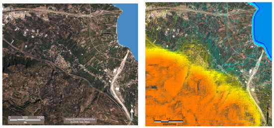
Figure 7.
(Left) Map of the current Helike Landscape. (Right) The DEM map overlay. The ranges of the colour code are only qualitative and as follows: 0–50 m elevation: cyan, 50–200 m: yellow, 200–997 m: orange.
The general shape of the shoreline before the earthquake of ca. 2100 BC, as shown in Figure 8 (left), aligns with the archaeological findings from excavations by the Helike Project.
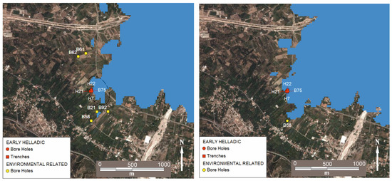
Figure 8.
(Left) The Helike landscape in the Early Helladic period before the earthquake of 2100 BC. (Right) The landscape after the earthquake of 2100 BC.
These excavations uncovered an Early Helladic II-III settlement featuring a “corridor house” and gridded streets [9,11]. Evidence from boreholes further supports the conclusion that this settlement was situated near the shoreline. Figure 8 (right) illustrates the landscape immediately after the earthquake. The marine transgression appears to have led to three lagoons, with the largest one centrally positioned in the bay and oriented northwest–southeast. It seems that, following the earthquake, the sea formed an enclosed lagoon in this orientation, located below the modern railway line.
Over time, the lagoon was gradually silted over, and by the Classical period, the shoreline had shifted close to the present-day railway line. Figure 9 (left) illustrates the landscape before the 373 BC earthquake. A small blue area in the centre, near excavated trench H8, suggests the presence of a lagoon, though it was more likely a swamp in 373 BC.
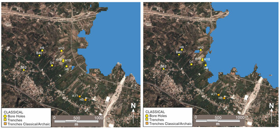
Figure 9.
(Left) The Helike landscape in the Classical period before the earthquake of 373 BC. (Right) The landscape after the earthquake of 373 BC.
Even today, part of the central Helike area is named “Valtos”, meaning “the swamps”, likely a remnant of an ancient lagoon that was initially open to the sea but later cut off by sediment deposition. According to a study on the Middle and Late Holocene paleogeography of the Helike Delta [14], in the 3rd/2nd millennium BC, the lagoon was small, stretching in the central/western part of the plain. After 1000 BC, it gradually grew to the northeast and by about 400 BC to the west. Following the 373 BC period, the lagoon occupied the central part of the plain, leaving on either side dry land for resettling.
This interpretation aligns with evidence of the Classical settlement in the area. Archaeological trench H8, the closest to the swamp, contained significant amounts of Archaic/Classical pottery at depths of 2.45–3.00 m, indicating that the area had silted over by that time. Trenches H18 and H19, located nearby, revealed Classical walls at a depth of 3 m, while H19 also contained ostracods [60] at 3.20 m beneath the walls, suggesting a previously brackish environment. These findings reinforce the presence of earlier marine, lagoonal, and marshy conditions at the site.
Figure 9 (right) illustrates the model following the 373 BC earthquake, highlighting the formation of two lagoons: one close to the centre of the picture and another further north, close to the Selinous River. Archaeological trench H10 is next to the lagoon at the centre. The Classical horizon was found at a depth of 3.70–3.90 m. Above it, there is evidence of a freshwater environment with freshwater ostracods, green and black clay, and up to 2 m, a black clay marshy environment appears. The model shows large areas being submerged near the shore after the earthquake.
The model shown in Figure 10 (left) simulates a 150-year progression from 373 BC to the Hellenistic period, corresponding to Eratosthenes’ account (3rd century BC) [2].
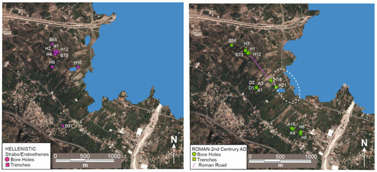
Figure 10.
(Left) The Helike landscape in the Hellenistic period. (Right) The landscape in the Roman period, at the time of Pausanias (2nd century AD).
Two key observations emerge: first, the Hellenistic settlement pattern shifted northwest compared to the Classical period. Second, the shoreline remained relatively stable, while the central shore area experienced prolonged submergence.
The interpretation is that the area was submerged under the sea for a considerable time and that the environment changed from marine to brackish. Furthermore, Eratosthenes reported that the bronze statue of Poseidon was in the “poros”, which has been re-interpreted as an inland lagoon [2]. The model showing a possible scenario in the 2nd century AD is presented in Figure 10 (right). By the 2nd century AD, the area was extensively silted over, as shown by the discovery of a major segment of an excavated Roman road, which runs through the site [10] (see magenta line in Figure 10, right).
Pausanias may have travelled along this Roman road and reported that the ruins of Helike were still visible underwater but heavily deteriorated. The models indicate that the lagoon is probably situated at the location annotated in Figure 10 (right), oriented NW–SE in the same location as the ancient lagoon. This view is further reinforced by extensive gravity measurements in the area by Dimitropoulos and Noutsis [74], whose results closely match the location and orientation of the lagoon as annotated.
This section has presented and demonstrated a method for landscape analysis through raster-based digital elevation models of the Helike landscape. DEMs are generated from dynamic models of sea level rises, coastal and tectonic pulse uplifts, subsidence, and sediment deposition. The present-day DEM was used to compile landscape models in the Early Helladic, Classical, Hellenistic, and Roman periods. Each model is validated by borehole and excavation data and interpreted in the light of ancient written sources. The models make several contributions to understanding the implications of the geomorphism of the Helike landscape to the continuity and discontinuity of human occupation.
5. Discussion
5.1. Seismicity and Settlement
Past earthquakes provide useful information on seismic risk assessment in a region. However, the scientific records offer quantifiable data on prior earthquakes from the beginning of the twentieth century. This period represents but a small record of the Holocene seismicity [4,5,38,39]. To expand this database, archaeological records are substantial in determining the damage inflicted on human structures revealed at archaeological sites [75,76,77,78,79,80,81,82]. Specifically, archaeology unravels the effects of ancient earthquakes on human communities by examining damage patterns and identifying seismic signs imprinted in human constructions and artefacts [7,11,12,13,15]. Archaeology, palaeoseismology, epigraphy, and historical texts are the primary sources of earthquake evidence. However, only the most severe seismic events would be recognised in all four sources, whereas smaller magnitude events might occur in some and rarely in all. In the current study, we calibrated the age of past earthquake events using dates resulting from combined 14C dating and archaeological evidence. The age of younger earthquakes is determined based on historical sources and 14C dating.
The timing of a disaster, its geographical location, the society affected, and the nature of the hazard are crucial elements that interact in various ways to differentiate a hazard from a disaster [83,84]. In the case of a series of earthquakes spanning over the Holocene, like in the Helike area, the pivotal factors are as follows. The first factor refers to the rate of onset and the duration of the incident. Devastating earthquakes, including the main event and aftershocks, may persist for months in the inflicted area. The second factor represents the extent of the affected region related to the earthquake magnitude or the proportion of the population struck. The third factor concerns the nature of the society inflicted. A society may be adaptable and mobile, like nomadic groups, or rigid, as, for instance, a settlement administered by a strong hierarchy or with a deep connection to specific geographical features. In our case, since Helike was the capital city in the region from the Early Bronze Age until the 4th century BC, i.e., for more than 20 centuries, it possessed a certain core societal value. The fourth factor involves the nature of the hazard and its recurrence, along with the accumulation of various types of hazards. In the case of Helike, the recurrence interval is typically in the order of more than four centuries, and in some cases, it is more than a millennium (Figure 11).
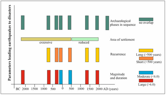
Figure 11.
Chart showing timing and magnitude of earthquake disasters in the Helike Plain, their geographical distribution, and the impact on the various chronological settlements (for discussion see text).
Additionally, successive hazards of different kinds may have the same cumulative effect characterised as a cascade disaster, also described as a ratchet effect by [7,85,86,87]. The 373 BC earthquake is not directly related to the HF and, therefore, could be considered a cascade event [7].
Frequent earthquakes will challenge the resilience of a community. Archaeological data acquired from the Helike Project excavations suggest that settlement locations changed positions over the centuries but always remained in the coastal plain, and primarily in the area bounded between the rivers Selinous (west) and Kerynites (east). It is worth noting that each habitation site, after abandonment due to earthquake destruction, bears no evidence of any subsequent occupation. On the contrary, revived settlements usually unfold in a new location, within the major Helike area, as set each time by current geological conditions. Thus, the Helike settlement sites since the Early Bronze Age compose a nucleus each time, which preserves the special features of the particular period of the settlement untouched. Figure 12 presents their mobility across the plain in time based on the excavation data.
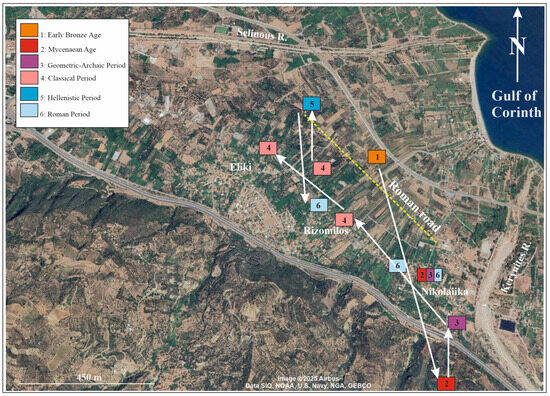
Figure 12.
Map of the Helike Plain showing movements and settlements from the 3rd millennium BC to the 1st millennium AD (for discussion see text).
5.2. Earthquake Destruction and Resilience
Beginning with the earliest proto-urban town of the 3rd millennium BC, exhibiting an organised building plan, including among its buildings a most outstanding monumental “corridor house”, Helike featured as an Early Bronze Age coastal centre associated with the rise of a new socio-economic structure at the time. In addition to advanced characteristics at the level of the settlement organisation, overseas links and contacts are evidenced through the presence of an array of exotic, prestigious items and commodities, including a unique depas cup of Anatolian type, ornaments of gold and silver, Melian obsidian tools, and the adoption of ‘international’ fashions of life such as the ‘serve and drink’ culture and ‘potter’s marks’ [11]. This cosmopolitan settlement came to an end ca. 2100 BC, struck by a strong earthquake accompanied by fire and subsequently buried under the sediments of a lagoon [60]. The collapse of the environmental and socio-economic systems resulted in the absence of any habitation sign in the central part of the plain for a very long period, as indicated by the stratigraphic excavation data. Human presence in this area is found again in the Archaic/Classical period down to the Hellenistic/Roman times, i.e., after a period of over a thousand years.
The facing of a serious environmental threat, ca. 2100 BC, and the burial of the destroyed settlement under lagoon deposits, seems to have driven people away from the watery lower lands of the mid-plain. Thus, in the following period from the Late Bronze Age (15th century BC) through to the Late Geometric/Archaic period (7th century BC), the new settlement was built on a safer location that occupied the lower plateau and higher sloping of the hill above the modern village of Nikolaiika (Figure 1a, N) at a distance of 1.5 km to the southeast of the abandoned Early Bronze Age habitation site (Figure 12). The settlement, dated from the 14th to the 11th century BC, occupied an area of about 20 acres, and was organised in groups of houses, including complexes formed of smaller rooms [61,88]. Mycenaean ‘broad’ Helike, as named in the Homeric epics, was part of the western territory of the Mycenaean kingdom of Agamemnon and participated—providing ships and crew—in the Trojan expedition under Agamemnon and his forces.
In the same general area, at the foot-mountain of the same hill, evolved the successor town of Geometric Helike, which founded the first and most powerful colony of the Achaeans in South Italy before the end of the 8th century BC (ca. 730 BC) [89]. Habitation in the proto-Geometric period, preceding the fully developed settlement of the Geometric metropolis of the 8th century BC, is evidenced via the Derveni grave pottery group, including the most popular Achaean drinking cup, the kantharos [90]. The influx of Corinthian products that reached the hinterland of Achaea since the second half of the 8th century BC [91] and exceptional objects from the eastern Mediterranean, such as the metal Phoenician models of clay vases dated to the early 7th century BC from a number of Achaean sites [92], suggest that Helike remained the commercial centre through which the area had fostered contacts with the East and the rest of the ancient world since the Early Bronze Age.
Previous experience of seismic disturbance may account for the solutions implemented by the Geometric society for the adjustment of architecture to the geomorphology, as we may infer from the foundation of the large Geometric building on the solidified conglomerate of the Helike Fault at this location (see Section 3.2). More importantly so, since the dimensions, the form and spaciousness of the construction—rather rare by the standards of the Geometric era—in conjunction with the abundance of drinking vessels recovered, suggest that the building hosted communal dining with many participants and most probably belonged to a local ruler or chieftain. The constant care and concern of the people in obtaining safety and stability for their structures is again evidenced in the use of polygonal masonry in the constructions of the post-373 BC earthquake settlement (see Section 3.3).
This flourishing culture was disrupted once again by another strong earthquake that occurred ca. 700–680 BC, and caused the abandonment of the site and its burial under thick river-borne fluvial deposits. However, recovery was attained shortly, as suggested by the archaeological finds dated to the 6th and 5th centuries BC from this area [12,93]. Further, the discovery of destroyed Classical walls by the 373 BC earthquake in more than one location to the west (see Section 3.3) indicates the expansion of the Classical settlement in a considerable length in the plain, coinciding with Helike’s elevation at the position of the capital city of the Achaean Dodekapolis, a place already held before during the predominance of the Ionians in the area. The foremost position of the Classical polis as both the political and religious seat of the Confederation, is witnessed, among other things, by the realisation of major projects in its territory, as was the construction of a sizeable marble temple and its sculptural decoration, all made of the most celebrated and costly marble of the ancient world, the Parian. The unique presence of the Parian marble in this region, the only site in the entire western Peloponnese before Olympia, places Helike along the maritime routes network for the export and diffusion of the valuable Parian marble to the West [94].
At the peak of its culture, Helike was smitten once again in 373 BC by another natural disaster, this time by a combined natural force of an earthquake and a sea wave [7]. Although believed in the past that there were no survivors and that the city disappeared from the face of the earth, the archaeological record has shown that, a few decades later, Helike was reborn, and a new settlement was built in the western part of the plain. The settlement soon grew in size and flourished, including in its premises, a large-scale textile industry, thus retaining its commercial and economic dynamics in the region and beyond (see Section 3.3). But yet, once more, the Hellenistic society’s attainments were forcibly discontinued by the strong earthquake of 90–80 BC [95] in another return of destruction over resilience. The latter, though, was soon restored within the same century through the rebuilding of the successor settlement of the Roman period in a new location to the east of the abandoned Hellenistic site. In keeping with the manifestations of a long tradition as transmitted by their ancestors, survivors continued to practice the inherited skills for crafts in the new settlement, as indicated by the excavation finds (see Section 3.4) [62].
The archaeological record so far suggests that throughout the centuries, in a repeated cycle of shortened natural disasters alternating with long periods of cultural and societal stability and growth, the Helike society consistently demonstrated resilience against destruction. It could be said that having confronted for generations with major environmental risks, society learned from past experience and formulated efficacious solutions to enhance resilience (Figure 13).
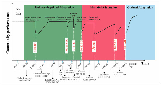
Figure 13.
Schematic diagram of the recovery process (resilience curve) following earthquake events in the Helike area. The diagram illustrates archaeological periods, the age of earthquakes, and the recovery time related to the pre-earthquake level. The green-shaded area indicates suboptimal society adaptation after earthquake damage, allowing the community to maintain a social level similar to the prior one; the red-shaded area highlights harmful society adaptation following the closely occurring earthquakes, every 300 years, between the Geometric and Hellenistic times. The light blue-shaded area shows the modern optimal adaptation following the 1861 earthquake. Adaptation nomenclature follows Klasa et al. [96].
Aware of this repeated system moving between destruction and resilience, the ancients worshipped Poseidon, the god of waters and earthquakes. In Helike, a land of high seismicity, Poseidon was the dominant deity, worshipped under the epithet of Helikonios [97]. In his sanctuary, mentioned in the Homeric epics, bull sacrifices took place to appease the god and secure safety for Helike’s land and people’s lives.
6. Conclusions
Helike serves as a striking example of a true palimpsest. Originally established during the Bronze Age (3rd millennium BC), it was repeatedly resettled during its long-lasting life down to Late Antiquity (1st millennium AD) as a result of natural phenomena. This study provides, for the first time, a complete catalogue of the historical earthquakes of the HF, a most on-land normal fault, which affected an area of continuous habitation over the last ten millennia. Furthermore, for almost all these earthquakes, we furnish their co-seismic and post-seismic phases based on (a) accurate earthquake recognition, (b) landscape description, and (c) human settlement and movement in the region (Figure 12). More specifically:
- We extended our documentation of earthquake phenomena into the past ten millennia based on palaeoseismology and archaeology data. Furthermore, we contributed to a better understanding of the recurrence interval of earthquakes along the Helike Fault as a causative structure that resulted in ground motions and physical impacts on settlements in the study area, thus filling in existing knowledge gaps. In particular, we focused on a cluster of four strong earthquake events (700–680 BC, 373 BC, 90–80 BC, and 420–450 AD), which devastated the Helike area at recurrence intervals ranging between 530 and 288 years. From a geological point of view, these earthquakes caused significant environmental changes in the area between the Selinous and Kerynites Rivers [7,37,95].
- It has been shown that the diachronic course of the Selinous and Kerynites Rivers, which drain the Helike Delta and border the permanently inhabited Helike area, was repeatedly altered by surface-rupturing earthquakes on the Helike Fault and a powerful off-fault earthquake event in 373 BC. However, the mechanisms associated with these earthquake events have not yet been thoroughly understood.
- Shifts of the ancient shoreline, landwards and seawards, in relation to the current seashore, have significantly contributed to our understanding of the diachronic evolution of the Helike settlements and the landscape over the Holocene.
- Living in a high-seismicity area and often experiencing natural disasters, the ancient people of Helike developed a certain adaptation of ‘seismically’ living, as characteristically shown by the building modes employed in the architecture to secure their constructions in terms of statics and endurance.
- Regarding the people’s predilection for continuous resettling in a seismically active plain, the landscape has played a crucial role. The Helike Plain is an alluvial, fertile land surrounded to the south by mountains, where three rivers originate, providing an abundance of water. To the north, the place is open to the sea, allowing easy access to sea voyages and trade routes. Its location as a commercial coastal centre in this part of northwest Peloponnese and the Gulf of Corinth favoured contacts and exchanges within the Mediterranean basin toward the East since the 3rd millennium BC, and to the West and its markets since the early historical times, when Helike founded the most powerful Achaean colony in South Italy, the city of Sybaris.
Author Contributions
D.K.: Conceptualization, excavation, supervision, writing—original draft, and overall editing. D.K. and I.K.: Methodology, writing—review and editing, and data analysis. I.K.: Geological analysis and palaeoseismological interpretation. M.K.: Landscape analysis, computer modelling, and writing—review and editing. All authors have read and agreed to the published version of the manuscript.
Funding
This research received no external funding.
Data Availability Statement
The data collected during the field work are available on request from the authors.
Acknowledgments
We thank the Institute for Aegean Prehistory in Philadelphia, USA, and the local Municipalities of Diakopton and Aigion for their support and contributions to the Helike Project excavations. We also thank the 3E company of Athens for supporting the earlier Helike Project work of borehole drilling.
Conflicts of Interest
The authors declare no conflicts of interest.
References
- Guidoboni, E.; Comastri, A.; Traina, G. Catalogue of Ancient Earthquakes in the Mediterranean Area up to the Tenth Century; Istituto Nazionale di Geofisica: Rome, Italy, 1994; p. 504. [Google Scholar]
- Katsonopoulou, D. The earthquake of 373 BC. Literary and archaeological evidence. In Helike III, Archaeological Sites in Geologically Active Regions; Katsonopoulou, D., Soter, S., Koukouvelas, I., Eds.; The Helike Society: Athens, Greece, 2005; pp. 15–32. [Google Scholar]
- Partida, E. The Disaster and the Experience of 373 BC Followed through the Architecture and Topography of Delphi. In POSEIDON—God of Earthquakes and Waters Cult and Sanctuaries; Katsonopoulou, D., Ed.; The Helike Society: Athens, Greece, 2017; pp. 227–258. [Google Scholar]
- Papazachos, B.; Papazachou, C. The Earthquakes of Greece; Ziti Publications: Thessaloniki, Greece, 2003; p. 304. [Google Scholar]
- Papadopoulos, G.A. Historical Earthquakes and Tsunamis in the Corinth Rift, Central Greece, Publication 12, National Observatory of Athens; Institute of Geodynamics: Athens, Greece, 2000; p. 128. [Google Scholar]
- Soter, S. Macroscopic seismic anomalies and submarine pockmarks in the Corinth–Patras rift, Greece. Tectonophysics 1999, 308, 275–290. [Google Scholar] [CrossRef]
- Koukouvelas, I.K.; Piper, D.J.W.; Katsonopoulou, D.; Kontopoulos, N.; Verroios, S.; Nikolakopoulos, K.; Zygouri, V. Earthquake-triggered landslides and mudflows: Was this the wave that engulfed Ancient Helike? Holocene 2020, 30, 1653–1668. [Google Scholar] [CrossRef]
- Marinatos, S.N. A submerged town of classical Greece. Archaeology 1960, 113, 186–193. [Google Scholar]
- Soter, S.; Katsonopoulou, D. Submergence and uplift of settlements in the area of Helike, from the Early Bronze Age to Late Antiquity. Geoarchaeology 2011, 26, 584–610. [Google Scholar] [CrossRef]
- Tsokas, G.N.; Tsourlos, P.I.; Stampolidis, A.; Katsonopoulou, D.; Soter, S. Tracing a Major Roman Road in the Area of Ancient Helike by Resistivity Tomography. Archaeol. Prospect. 2009, 16, 251–266. [Google Scholar] [CrossRef]
- Katsonopoulou, D.; Katsarou, S. Mainland cosmopolitanism and the rise of personal prestige: New evidence from the coastal Early Helladic town of Helike, northwest Peloponnese. BSA 2017, 112, 1–32. [Google Scholar] [CrossRef]
- Katsonopoulou, D.; Partida, E. Filling a Gap in the History of an Achaean Leader City: Post-373 B.C. Helike. NAC 2023, 52, 169–199. [Google Scholar]
- Weir, R. Was Hellenistic Helike a Typical Polis? A Comparative Study of Numismatic Contexts. In Helike After 373 BC—An Interdisciplinary Approach; Katsonopoulou, D., Ed.; The Helike Society: Athens, Greece, 2024; pp. 123–135. [Google Scholar]
- Koutsios, A. Middle to Late Holocene Paleogeography of Helike Delta Plain. Application in Archaeological Research. Ph.D. Thesis, University of Patras, Patras, Greece, 2009; p. 497. [Google Scholar]
- Gaggioli, A. The geoarchaeology of seismically triggered soft sediment deformation structures (SSDS). J. Archaeol. Sci. 2024, 165, 105961. [Google Scholar] [CrossRef]
- Kontopoulos, N.; Avramidis, P. Geological Reconstruction of Ancient Coastal Landforms in North Peloponnesos, Greece. An Example from Aliki Lagoon. In Ancient Helike and Aigialeia—Archaeological Sites in Geologically Active Regions; Katsonopoulou, D., Soter, S., Koukouvelas, I., Eds.; The Helike Society: Athens, Greece, 2005; pp. 293–301. [Google Scholar]
- Redman, C.L. Resilience Theory in Archaeology. Am. Anthropol. 2005, 107, 70–77. [Google Scholar] [CrossRef]
- Lonergan, K.E.; Greco, S.F.; Sansavini, G. Ensuring/insuring resilient energy system infrastructure. Environ. Syst. Decis. 2023, 43, 625–638. [Google Scholar] [CrossRef]
- Nixon, C.W.; McNeill, L.C.; Bull, J.M.; Bell, R.E.; Gawthorpe, R.L.; Henstock, T.J.; Christodoulou, D.; Ford, M.; Taylor, B.; Sakellariou, D.; et al. Rapid spatiotemporal variations in rift structure during development of the Corinth Rift, central Greece. Tectonics 2016, 35, 1225–1248. [Google Scholar] [CrossRef]
- Doutsos, T.; Kontopoulos, N.; Poulimenos, G. The Corinth-Patras Rift as the initial stage of continental fragmentation behind an active island arc (Greece). Basin Res. 1988, 1, 177–190. [Google Scholar] [CrossRef]
- Maffione, M.; Herrero-Bervera, E. A relative Paleointensity (RPI)-calibrated age model for the Corinth syn-rift sequence at IODP hole M0079A (gulf of Corinth, Greece). Front. Earth Sci. 2022, 10, 813958. [Google Scholar] [CrossRef]
- Rusch, K.; Stümpel, H.; Gauß, W.; Müth, S.; Sokolicek, A.; Kissas, K.; Rabbel, W. Geological Challenges of Archaeological Prospecting: The Northern Peloponnese as a Type Location of Populated Syn-Rift Settings. Remote Sens. 2020, 12, 2450. [Google Scholar] [CrossRef]
- de Vals, M.; Moretti, I. Geology and construction: Survey of archaeological sites and their natural environments (Gulf of Corinth, Greece). Comptes Rendus. Geosci. 2022, 354, 51–73. [Google Scholar] [CrossRef]
- Pechlivanidou, S.; Cowie, P.A.; Duclaux, G.; Nixon, C.W.; Gawthorpe, R.L.; Salles, T. Tipping the balance: Shifts in sediment production in an active rift setting. Geology 2019, 47, 259–262. [Google Scholar] [CrossRef]
- Gawthorpe, R.L.; Leeder, M.R. Tectono-sedimentary evolution of active extensional basins. Basin Res. 2000, 12, 195–218. [Google Scholar] [CrossRef]
- Perissoratis, C.; Piper, D.J.W.; Lykousis, V. Alternating marine and lacustrine sedimentation during late Quaternary in the Gulf of Corinth Rift basin, central Greece. Mar. Geol. 2000, 167, 391–411. [Google Scholar] [CrossRef]
- Leeder, M.R.; Mack, G.H.; Brasier, A.T.; Parrish, R.R.; McIntosh, W.C.; Andrews, J.E.; Duermeijer, C.E. Late-Pliocene timing of Corinth (Greece) rift-margin fault migration. Earth Planet. Sci. Lett. 2008, 274, 132–141. [Google Scholar] [CrossRef]
- Ford, M.; Hemelsdaël, R.; Mancini, M.; Palyvos, N. Rift Migration and Lateral Propagation: Evolution of Normal Faults and Sediment-Routing Systems of the Western Corinth Rift (Greece). Geol. Soc. Spec. Publ. 2017, 493, 131–168. [Google Scholar] [CrossRef]
- Ori, G.G.; Roveri, M.; Nichols, G. Architectural patterns in large-scale Gilbert-type delta complexes, Pleistocene, Gulf of Corinth, Greece. In The Three Dimensional Facies Architecture in Terrigenous Clastic Sediments and its Implications for Hydrocarbon Discovery and Recovery; Miall, A.D., Tyler, N., Eds.; SEPM, Concept in Sedimentology and Paleontology: Tulsa, OK, USA, 1991; pp. 207–216. [Google Scholar]
- Floyd, M.A.; Billiris, H.; Paradissis, D.; Veis, G.; Avallone, A.; Briole, P.; McClusky, A.S.; Nocquet, J.M.; Palamartchouk, K.; Parsons, B.; et al. A new velocity field for Greece: Implications for the kinematics and dynamics of the Aegean. J. Geophys Res. 2010, 115, B10403. [Google Scholar] [CrossRef]
- Nixon, C.W.; McNeill, L.C.; Gawthorpe, R.L.; Shillington, D.J.; Michas, G.; Bell, R.E.; Moyle, A.; Ford, M.; Zakharova, N.V.; Bull, J.M.; et al. Increasing fault slip rates within the Corinth rift, Greece: A rapidly localising active rift fault network. Earth Planet. Sci. Lett. 2024, 636, 118716. [Google Scholar] [CrossRef]
- Gawthorpe, R.L.; Fabregas, N.; Pechlivanidou, S.; Ford, M.; Collier, R.E.L.; Carter, G.D.O.; McNeill, L.C.; Shillington, D.J. Late Quaternary mud-dominated, basin-floor sedimentation of the Gulf of Corinth, Greece: Implications for deep-water depositional processes and controls on syn-rift sedimentation. Basin Res. 2022, 34, 1567–1600. [Google Scholar] [CrossRef]
- Koukouvelas, I.; Stamatopoulos, L.; Katsonopoulou, D.; Pavlides, S. A palaeoseismological and geoarchaeological investigation of the Eliki Fault, Gulf of Corinth, Greece. J. Struct. Geology 2001, 23, 531–543. [Google Scholar] [CrossRef]
- Doutsos, T.; Piper, D.J.W. Listric Faulting, Sedimentation, and Morphological Evolution of the Quaternary Eastern Corinth Rift, Greece: First Stages of Continental Rifting. Bull. Geol. Soc. Am. 1990, 102, 812–829. [Google Scholar] [CrossRef]
- Verroios, S.; Zygouri, V. Geomorphological Analysis of Xilokastro Fault, Central Gulf of Corinth, Greece. Geosciences 2021, 11, 516. [Google Scholar] [CrossRef]
- Koukouvelas, I.; Katsonopoulou, D.; Soter, S.; Xypolias, P. Slip rates on the Helike Fault, Gulf of Corinth, Greece: New evidence from geoarchaeology. Terra Nova 2005, 17, 158–164. [Google Scholar] [CrossRef]
- Pavlides, S.; Koukouvelas, I.; Kokkalas, S.; Stamatopoulos, L.; Keramydas, D.; Tsodoulos, I. Late Holocene Evolution of the East Eliki fault, Gulf of Corinth (Central Greece). J. Quat. Int. 2004, 115–116, 139–154. [Google Scholar] [CrossRef]
- Ambraseys, N. Earthquakes in the Mediterranean and Middle East: A Multidisciplinary Study of Seismicity up to 1900; Cambridge University Press: Cambridge, UK, 2009; p. 968. [Google Scholar]
- Mouyaris, N.; Papastamatiou, D.; Vita-Finzi, C. The Helice fault? Terra Nova 1992, 4, 124–129. [Google Scholar] [CrossRef]
- Doutsos, T.; Poulimenos, G. Geometry and kinematics of active faults and their seismotectonic significance in the western Corinth–Patras rift (Greece). J. Struct. Geol. 1992, 14, 689–699. [Google Scholar] [CrossRef]
- Albini, P.; Rovida, A.; Scotti, O.; Lyon-Caen, H. Large Eighteenth–Nineteenth Century Earthquakes in Western Gulf of Corinth with Reappraised Size and Location. Bull. Seismol. Soc. Am. 2017, 107, 1663–1687. [Google Scholar] [CrossRef]
- Kaviris, G.; Elias, P.; Kapetanidis, V.; Serpetsidaki, A.; Karakonstantis, A.; Plicka, V.; De Barros, L.; Sokos, E.; Kassaras, I.; Sakkas, V.; et al. The Western Gulf of Corinth (Greece) 2020–2021 Seismic Crisis and Cascading Events: First Results from the Corinth Rift Laboratory Network. Seism. Rec. 2021, 1, 85–95. [Google Scholar] [CrossRef]
- Moretti, I.; Sakellariou, D.; Lykousis, V.; Micarelli, L. The Gulf of Corinth: An active half graben? J. Geodyn. 2003, 36, 323–340. [Google Scholar] [CrossRef]
- McNeill, L.C.; Collier, R.; Pantosti, D.; Marco de Martini, P.; D’Addezio, G. Recent history of the Eastern Helike Fault: Geomorphology, paleoseismology and impact on paleoenviornments. In Helike III, Archaeological Sites in Geologically Active Regions; Katsonopoulou, D., Soter, S., Koukouvelas, I., Eds.; The Helike Society: Athens, Greece, 2005; pp. 243–265. [Google Scholar]
- Bell, R.E.; McNeill, L.C.; Bull, J.M.; Henstock, T.J.; Collier, R.E.L.; Leeder, M.R. Fault architecture, basin structure and evolution of the Gulf of Corinth Rift, central Greece. Basin Res. 2009, 21, 824–855. [Google Scholar] [CrossRef]
- Taylor, B.; Weiss, J.R.; Goodliffe, A.M.; Sachpazi, M.; Laigle, M.; Hirn, A. The structures, stratigraphy and evolution of the Gulf of Corinth Rift, Greece. Geophys. J. Int. 2011, 185, 1189–1219. [Google Scholar] [CrossRef]
- Charalampakis, M.; Lykousis, V.; Sakellariou, D.; Papatheodorou, G.; Ferentinos, G. The Tectono-Sedimentary Evolution of the Lechaion Gulf, the South Eastern Branch of the Corinth Graben, Greece. Mar. Geol. 2014, 351, 58–75. [Google Scholar] [CrossRef]
- Palyvos, N.; Pantosti, D.; DeMartini, P.M.; Lemeille, F.; Sorel, D.; Pavlopoulos, K. The Aigion-Neos Erineos normal fault system (Western Corinth Gulf Rift, Greece): Geomorphological signature, recent earthquake history and evolution. J. Geophys. Res. 2005, 110, B09302. [Google Scholar] [CrossRef]
- Sorel, D. Pleistocene and still-active detachment fault and the origin of the Corinth-Patras rift [Greece]. Geology 2000, 28, 83–86. [Google Scholar] [CrossRef]
- Rigo, A. Etude Sismotectonique et Géodésique du Golfe de Corinthe (Grèce). Ph.D. Thesis, Paris VI, Paris, France, 1994; p. 281. [Google Scholar]
- Armijo, R.; Meyer, B.; King, G.C.P.; Rigo, A.; Papanastassiou, D. Quaternary evolution of the Corinth Rift and its implications for the Late Cenozoic evolution of the Aegean. Geophys. J. Int. 1996, 126, 11–53. [Google Scholar] [CrossRef]
- Soter, S. Holocene uplift and subsidence of the Helike Delta, Gulf of Corinth, Greece. In Coastal Tectonics; Stewart, I., Vita-Finzi, C., Eds.; Geological Society, London, Special Publications: London, UK, 1998; Volume 146, pp. 41–56. [Google Scholar]
- Briole, P.; Rigo, A.; Lyon-Caen, H.; Ruegg, J.; Papazissi, K.; Mistakaki, C.; Balodimou, A.; Veis, G.; Hatzfeld, D.; Deschamps, A. Active deformation, of the gulf of Korinthos, Greece: Results from repeated GPS surveys between 1990 and 1995. J. Geophys. Res. 2000, 105, 25605–25625. [Google Scholar] [CrossRef]
- Stewart, I. Holocene uplift and palaeoseismicity on the Eliki Fault, western Gulf of Corinth, Greece. Ann. Geof. 1996, 39, 575–588. [Google Scholar] [CrossRef]
- De Martini, P.; Pantosti, D.; Palyvos, N.; Lemeille, F.; McNeill, L.; Collier, R. Slip rates of the Aigion and Eliki faults from uplifted marine terraces, Corinth Gulf, Greece. Comptes Rendus Geosci. 2004, 336, 325–334. [Google Scholar] [CrossRef]
- McNeill, L.C.; Collier, R.E.L.L. Uplift and slip rates of the eastern Eliki fault segment, Gulf of Corinth, Greece, inferred from Holocene and Pleistocene terraces. J. Geol. Soc. 2004, 161, 81–92. [Google Scholar] [CrossRef]
- McNeill, L.C.; Collier, R.E.L.; de Martini, P.M.; Pantosti, D.; D’Addezio, G. Recent history of the eastern Eliki fault, Gulf of Corinth: Geomorphology, palaeoseismology and impact on palaeoenvironments. Geophys. J. Int. 2005, 161, 154–166. [Google Scholar] [CrossRef]
- Schmidt, J. Studien Über Erdbeben; Carl Schottze: Leipzig, Germany, 1879; pp. 68–83. [Google Scholar]
- Katsarou-Tzeveleki, S. Morphology and Distribution of Pottery at the Early Helladic Settlement of Helike. In Helike IV, Protohelladika—The Southern and Central Greek Mainland; Katsonopoulou, D., Ed.; The Helike Society: Athens, Greece, 2011; pp. 89–126. [Google Scholar]
- Alvarez-Zarikian, C.A.; Soter, S.; Katsonopoulou, D. Recurrent submergence and uplift in the area of Ancient Helike, Gulf of Corinth, Greece: Microfaunal and archaeological evidence. J. Coast. Res. 2008, 24, 110–125. [Google Scholar] [CrossRef]
- Tsokas, G.N.; Tsourlos, P.I.; Stambolidis, A.; Katsonopoulou, D.; Tsokas, A.N.G. Geophysical prospection at the Mycenaean cemetery in the area of ancient Helike, Achaea, Greece. In Helike V: Ancient Helike and Aigialeia; Katsonopoulou, D., Ed.; The Helike Society: Athens, Greece, 2017; pp. 167–180. [Google Scholar]
- Katsonopoulou, D. An Unknown Earthquake Revealed in Roman Helike. In HELIKE VI, Helike After 373 BC—An Interdisciplinary Approach; Katsonopoulou, D., Ed.; The Helike Society: Athens, Greece, 2024; pp. 349–364. [Google Scholar]
- Karali, L. Death by Earthquake in Ancient Helike. In Helike VI, Helike after 373 BC—An Interdisciplinary Approach; Katsonopoulou, D., Ed.; The Helike Society: Athens, Greece, 2024; pp. 365–372. [Google Scholar]
- Ingold, T. The Temporality of the Landscape. World Archaeol. 1993, 25, 152–174. [Google Scholar] [CrossRef]
- Patrick, G.T.W. The Fragments of the work of Heraclitus of Ephesus on Nature; Press of Isaac Friedenwald: Baltimore, MD, USA, 1889. [Google Scholar]
- Lock, G. Using Computers in Archaeology: Towards Virtual Pasts; Routledge: London, UK, 2003. [Google Scholar]
- Polla, S.; Verhagen, P. Introduction. In Computational Approaches to the Study of Movement in Archaeology; Polla, S., Verhagen, P., Eds.; Walter de Gruyter GmbH: Berlin, Germany; Boston, MA, USA, 2014; pp. 1–4. [Google Scholar][Green Version]
- Lock, G.; Kormann, M.; Pouncett, J. Visibility and Movement: Towards a GIS-Based integrated approach. In Computational Approaches to the Study of Movement in Archaeology; Polla, S., Verhagen, P., Eds.; Walter de Gruyter GmbH: Berlin, Germany; Boston, MA, USA, 2014; pp. 23–42. [Google Scholar][Green Version]
- Heidegger, M. Building, Dwelling, Thinking; Krell, D.F., Ed.; Martin Heidegger: Basic Writings; Hofstadter, A., Translator; Routledge: London, UK, 1993; pp. 217–265. [Google Scholar][Green Version]
- Wagstaff, M. The Landscape of the Selinous/Kerynites Delta in AD 1700. In Ancient Helike and Aigialeia-Archaeological Sites in Geologically Active Regions; Katsonopoulou, D., Soter, S., Koukouvelas, I., Eds.; The Helike Society: Athens, Greece, 2005; pp. 67–74. [Google Scholar][Green Version]
- Sutton, S.B. Settlement patterns, settlement perceptions: Rethinking the Greek village. In Beyond the Site: Regional Studies in the Aegean Area; Kardulias, P.N., Ed.; University Press of America: Lanham, MD, USA; New York, NY, USA; London, UK, 1994; pp. 313–335. [Google Scholar][Green Version]
- Weiberg, E. Topography and Settlement: Perception of the Bounded Space. In Protohelladika—The Southern and Central Greek Mainland; Katsonopoulou, D., Ed.; The Helike Society: Athens, Greece, 2011; pp. 45–61. [Google Scholar][Green Version]
- Bradley, R. An Archaeology of Natural Places; Routledge: London, UK, 2000; p. 192. [Google Scholar][Green Version]
- Dimitropoulos, K.G.; Noutsis, G. Gravity Evidence on the Location of the Lost Ancient City of Helike. In Helike III Ancient Helike and Aigialeia, Archaeological Sites in Geologically Active Regions; Katsonopoulou, D., Soter, S., Koukouvelas, I., Eds.; The Helike Society: Athens, Greece, 2005; pp. 197–200. [Google Scholar][Green Version]
- Galadini, F.; Ceccaroni, E.; Dixit Dominus, G.; Falcucci, E.; Gori, S.; Maceroni, D.; Bonasera, M.; Di Giulio, G.; Moro, M.; Saroli, M.; et al. Combining earth sciences with archaeology to investigate natural risks related to the cultural heritage of the Marsica region (central Apennines, Italy). Mediterr. Geosci. Rev. 2022, 4, 287–318. [Google Scholar] [CrossRef]
- Sintubin, M.; Stewart, I.S.; Niemi, T.; Altunel, E. (Eds.) Ancient earthquakes. Geol. Soc. Am. Spec. Pap. 2010, 471, 280. [Google Scholar]
- Bottari, C.; Capizzi, P.; Sortino, F. Unravelling the Seismic Source in Archaeoseismology: A Combined Approach on Local Site Effects and Geochemical Data Integration. Heritage 2024, 7, 427–447. [Google Scholar] [CrossRef]
- Rapp, G. Assessing archaeological evidence for seismic catastrophes. Geoarchaeology 1986, 1, 365–379. [Google Scholar] [CrossRef]
- Nikonov, A.A. Reconstruction of the main parameters of old large earthquakes in Soviet Central Asia using the palaeoseismological method. Tectonophysics 1988, 147, 297–312. [Google Scholar] [CrossRef]
- Rucker, J.D.; Niemi, T.N. Historical earthquake catalogues and archaeological data: Achieving synthesis without circular reasoning. In Ancient Earthquakes; Sintubin, M., Stewart, I.S., Niemi, T.N., Altunel, E., Eds.; Geological Society of America: Boulder, CO, USA, 2010; Volume 471, pp. 97–106. [Google Scholar]
- Marco, S. Recognition of earthquake-related damage in archaeological sites: Examples from the Dead Sea fault zone. Tectonophysics 2008, 453, 148–156. [Google Scholar] [CrossRef]
- Stewart, I.S. Advancing disaster risk communications. Earth Sci. Rev. 2024, 249, 104677. [Google Scholar] [CrossRef]
- Rodríguez-Pascua, M.A.; Pérez-López, R.; Giner-Robles, J.L.; Silva, P.G.; Garduño-Monroy, V.H.; Reicherter, K. A comprehensive classification of earthquake archaeological effects (EAE) in archaeoseismology: Application to ancient remains of Roman and Mesoamerican cultures. Quat. Int. 2011, 242, 20–30. [Google Scholar] [CrossRef]
- Leroy, S.A.G. Natural Hazards, Landscapes, and Civilizations. Reference Module in Earth Systems and Environmental Sciences; Elsevier: Amsterdam, The Netherlands, 2020. [Google Scholar] [CrossRef] [PubMed Central]
- Wood, E.; Miller, S.K. Cognitive dissonance and disaster risk communication. J. Emerg. Manag. Disaster Commun. 2021, 2, 39–56. [Google Scholar] [CrossRef]
- Ford, M.; Williams, E.; Malartre, F.; Popescu, S.-M. Stratigraphic architecture, sedimentology and structure of the Vouraikos Gilbert-type fan delta, Gulf of Corinth, Greece. In Sedimentary Processes, Environments and Basins. A Tribute to Peter Friend; Nichols, G., Williams, E., Paola, C., Eds.; International Association of Sedimentologists Special Publication: Huelva, Spain, 2009; Volume 39, pp. 49–90. [Google Scholar]
- Chambers, R. Vulnerability. Editorial introduction. IDS Bull. 1989, 20, 1–7. [Google Scholar] [CrossRef]
- Kolia, E. Excavation research in eastern Achaea (in Greek). Arxaiologia 2015, 119, 62–73. [Google Scholar]
- Luppino, S. La Produzione Artistica di Sibari Dalla Fondazione alla Distruzione del 510 a.C. In Ancient Helike and Aigialeia; Katsonopoulou, D., Soter, S., Schilardi, D., Eds.; The Helike Society: Athens, Greece, 1998; pp. 361–369. [Google Scholar]
- Coldstream, J.N. Greek Geometric Pottery: A Survey of Ten Local styles and Their Chronology; Methuen: London, UK, 1968; 528p. [Google Scholar]
- Bozana-Kourou, N. Grave finds from the area of Aigion (in Greek). In Memory of N. Kontoleon; Schefold, K., Pouilloux, J., Eds.; Somateio ton filon Nikolaou Kontoleontos: Athens, Greece, 1980; pp. 303–320. [Google Scholar]
- Papadopoulos, J.K. Magna Achaea: Akhaian Late Geometric and Archaic pottery in South Italy and Sicily. Hesperia 2001, 70, 373–460. [Google Scholar] [CrossRef]
- Kolia, E. Archaic Terracotta Reliefs from Ancient Helike. Hesperia 2014, 83, 409–445. [Google Scholar] [CrossRef]
- Katsonopoulou, D. Recent Evidence of Sculptures in Parian Marble. In Paros and Its Colonies; Katsonopoulou, D., Ed.; The Institute for Archaeology of Paros and the Cyclades: Athens, Greece, 2018; pp. 101–113. [Google Scholar]
- Katsonopoulou, D.; Koukouvelas, I. Earthquake Environmental Effects: The Case of the Late Classical-Hellenistic Helike, Gulf of Corinth, Greece. Geosciences 2024, 14, 311. [Google Scholar] [CrossRef]
- Klasa, K.; Trump, B.D.; Dulin, S.; Smith, M.; Jarman, H.; Linkov, I. A Resilience-Augmented Approach to Compound Threats and Risk Governance: A Systems Perspective on Navigating Complex Crises. Environments 2025, 12, 64. [Google Scholar] [CrossRef]
- Petropoulos, I. Poseidon’s Homeric Epithets and Titles. In POSEIDON—God of Earthquakes and Waters. Cult and Sanctuaries; Katsonopoulou, D., Ed.; The Helike Society: Athens, Greece, 2017; pp. 99–110. [Google Scholar]
Disclaimer/Publisher’s Note: The statements, opinions and data contained in all publications are solely those of the individual author(s) and contributor(s) and not of MDPI and/or the editor(s). MDPI and/or the editor(s) disclaim responsibility for any injury to people or property resulting from any ideas, methods, instructions or products referred to in the content. |
© 2025 by the authors. Licensee MDPI, Basel, Switzerland. This article is an open access article distributed under the terms and conditions of the Creative Commons Attribution (CC BY) license (https://creativecommons.org/licenses/by/4.0/).