1. Introduction
The Recent Bronze Age (1350/1300-1150 BCE) in the central-eastern Veneto region (Italy) witnessed a significant and accelerating population increase, notably along the major rivers (Bacchiglione, Brenta, Sile, Piave, Lemene and Livenza), as well as at their estuaries, indicating control over the coastal zone. While the precise drivers of this growth are still under investigation, it is consistent with the broader pattern of expanding settlement documented across the whole Veneto region during this period [
1].
Observing the coastal strip of the Adriatic Sea from south to north, with a focus on the Venice lagoon’s edge and its immediate hinterland, the later phase of the Recent Bronze Age saw the emergence of the embanked site of Cona–Cantarana, strategically positioned to control a key point between the Po River delta and the Adriatic coast, and the embanked site of Boion, located in proximity to a probable former sea outlet of the Brenta River. Moving further north, the most notable population clusters were situated during this same period within a peri-lagoonal zone, specifically including the territory of Mestre and the municipalities of Meolo and Quarto d’Altino. A limited presence is also attested within the lagoon itself, as evidenced by the archaeological record at Barena del Vigno. Eastern Veneto appears to follow a similar trend, showing a consistent pattern of settlement along the peri-lagoonal fringe, especially near the mouth systems of the major rivers and within the lagoon areas themselves, as illustrated by the sites of Cittanova–Eraclia and Caorle–San Gaetano.
Mirroring the broader Veneto region, the Final Bronze Age 1–2 (1175/50-1000 BCE) in the Venetian area marks a period of significant population reduction, with the settlement at Caorle–San Gaetano representing the sole continuous occupation controlling the para-coastal routes. Conversely, the Final Bronze Age 3 is characterised by a resurgence in territorial occupation, albeit one that was not as widespread or ubiquitous as in the recent Bronze Age but rather confined to specific areas. It is during this later phase that settlement was re-established in the vicinity of future
Altinum, strategically positioned to control the lower course of the Sile River and its associated peri-lagoonal zone. Caorle–San Gaetano was, in all probability, succeeded in its role by the area of present-day Concordia, which was already active during the recent Bronze Age [
2] (pp. 300–304), [
3,
4,
5,
6,
7].
Within this established context of protohistoric settlement along the Venice lagoon’s littoral and immediate hinterland, the recently identified site at Mira–Giare constitutes a novel and somewhat unexpected data point emerging from preventive archaeological investigations. The site appears to fill a perceived settlement lacuna within a central segment of the lagoon’s littoral. The prior absence of archaeological evidence may be ascribed to a documentary deficit, potentially resulting from a lack of previous systematic archaeological investigations and/or issues concerning the subsurface visibility of the buried deposit.
These preliminary considerations prompted an in situ intensification of site investigation during the excavation phase, deploying a suite of supplementary analyses designed to maximise data acquisition for comprehensive archaeological and geomorphological reconstruction.
The main scientific questions we tried to answer with the in-depth investigations conducted while the archaeological excavation was still underway were as follows: what was the context of the structures, and how far did the production site extend? Answering these questions would allow for the discoveries to be framed within a broader context, both geographically and historically–culturally. It would also help in estimating the importance and complexity of the productive activity documented by the pyro-technological structures brought to light.
2. Setting
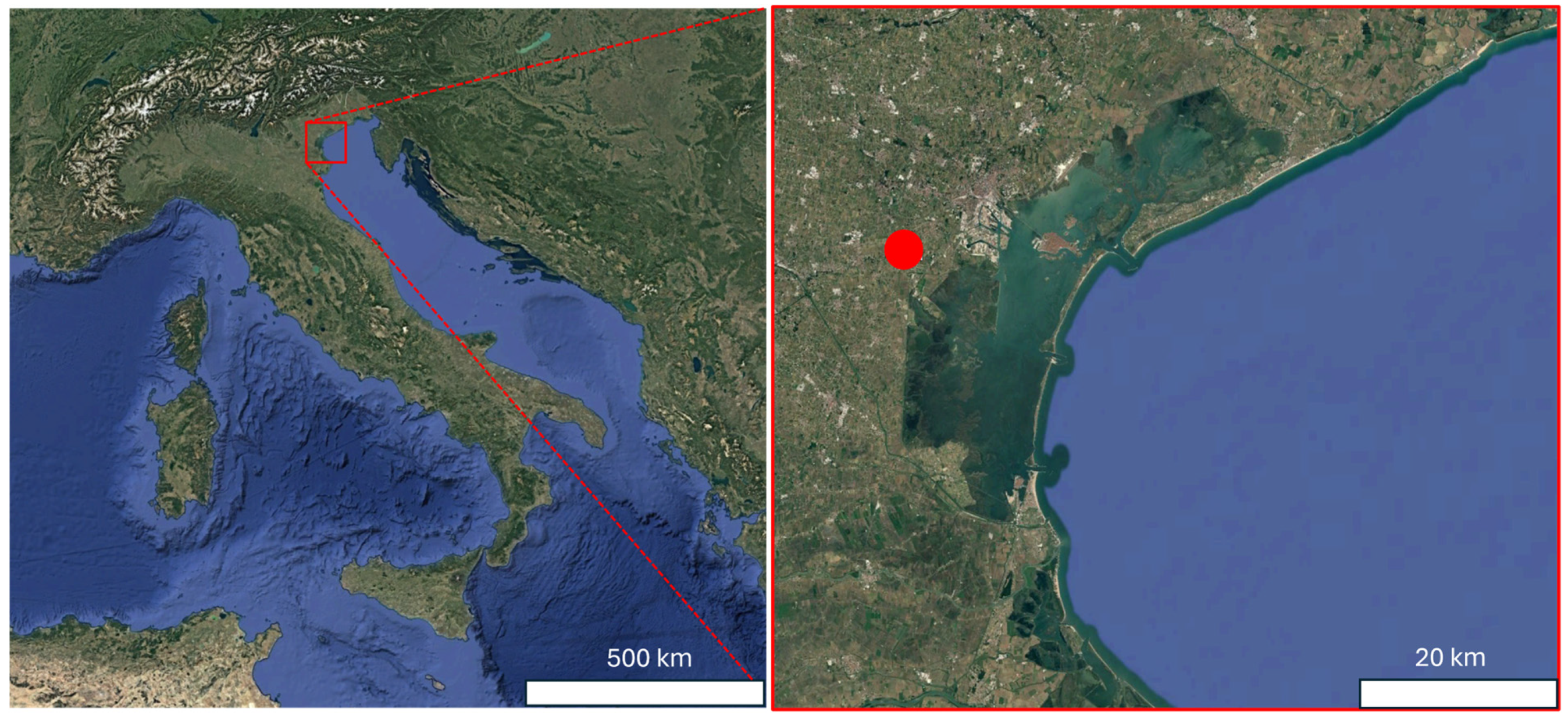
The archaeological site is located some hundred metres from the current inner margin of the lagoon of Venice (
Figure 1), which is here bordered by a several-metre-high artificial level. The Venice lagoon is characterised by geological subsidence that brings about a continuous rise in relative sea level, estimated at around 1.2–1.3 mm yr
−1 for the last two thousand years [
8,
9]. The study area is now at an elevation around −1 m Mean Sea Level (MSL).
The site falls within the deltaic system of a mediaeval branch of the Brenta River, which has been debouching in the lagoon starting from the 12th century AD [
10,
11] (
Figure 2). Between the mediaeval fluvial ridges, large stretches of the alluvial plain built by the Brenta River during the Last Glacial Maximum (LGM) crop out. These latter alluvial deposits belong to the Brenta megafan and are characterised by a typical calcic soil that is also found buried under the post-LGM lagoonal and fluvial deposits [
12,
13].
A Holocene palaeochannel of the Brenta River has been traced in the area through remote sensing, and it was radiocarbon-dated to the late Bronze Age [
11]. Due to relative sea level rise [
5], the Bronze Age inner margin of the lagoon is now below MSL. Geological investigations evidence the presence of buried deltaic deposits of the 2nd millennium BC in the underground area of the present lagoon SE of the Giare area [
14]. This allows us to hypothesise the location of the Bronze Age lagoon margin as shown in
Figure 2.
The new archaeological evidence of the Giare site consists of a productive context characterised by the presence of pyro-technological structures and provisionally dates to the transition from the late Recent Bronze Age to the early Final Bronze Age, based on a preliminary typological assessment of the recovered artefacts. Bronze Age chronological references throughout this paper are based on the frameworks proposed by [
1,
15,
16].
3. Materials and Methods
Investigations at the Giare archaeological site, located in the municipality of Mira (VE), near the current lagoon margin, began in 2023. This was in connection with a major public works project aimed at the hydraulic arrangement, environmental restoration and landscape redevelopment of a portion of the drainage water network in the central-southern Venice lagoon (
Figure 3).
Developed by the Consorzio di Bonifica Acque Risorgive, the project underwent preliminary Preventive Archaeological Interest Verification (VPIA) in 2020, as required by Article 25 of Legislative Decree 50/2016 (now Article 1, paragraphs 2 and 3, Annex I.8 of Legislative Decree 36/2023). The preliminary documentation assessed the archaeological risk as moderate, within a context characterised by massive areal deposits resulting from recent agricultural exploitation. As a result, the project was approved, conditioned upon continuous archaeological monitoring for soil disturbance operations reaching greater depths beyond the ground surface.
Archaeological excavations began in March 2023, carried out by Se.Arch. Srl, under the scientific direction of Soprintendenza Archeologia, Belle Arti e Paesaggio per il Comune di Venezia e Laguna. In April of the same year, the first anthropogenic deposits were identified, characterised by abundant pre-Roman ceramic material. This discovery, surprising as it was not predicted by the existing literature, yielded the opening of a trench and three excavation test units in distinct areas of the site, with the aim of clarifying the nature and chronology of the findings (
Figure 4).
Stratigraphic investigations were carried out between April 2023 and July 2024, with numerous interruptions due to adverse weather conditions and rising groundwater. From the early stages of excavation, the exceptional nature of the discovery became evident: the recovered ceramic materials and the associated pyro-technological structural evidence pointed to a production site, dating between the late Recent Bronze Age 2 (first half of the 12th century BCE) and the early Final Bronze Age 1–2 (1175/50-1000 BCE), a chronological phase not previously recorded in this locality [
17].
Non-invasive geophysical measurements in the analysis of production sites of the Bronze Age, and more generally in this type of context, are typically taken by magnetic measurements [
18,
19,
20,
21,
22], and in a few cases, this method appears to be coupled with Ground-Penetrating Radar (GPR) acquisitions [
23,
24] for the same purposes. In general, the absence of actual remains of structures of a specific size, with the presence of distributed traces of thin layers, pits and small-in-size remains instead, which can be related to pyro-technological activities within shallow depths, allows the fruitful use of these methods, efficient in shallow systems. Furnaces and fired materials represent the ideal target for magnetic methods, while more sporadically, GPR provides high resolution in searching for the presence of shallow and thin structures, which are generally present in this type of site [
25]. Electrical resistivity tomography (ERT), well-known for its use in searching built buried structures [
26,
27], is well documented in investigations involving geomorphologically complex sites, such as those often encountered in Bronze Age contexts [
28,
29,
30,
31]. The presence of palaeochannels and systems related to water circulation that may involve depths greater than the actual, shallower sediment of the archaeological settlement provides an easy target for this prospecting method. Therefore, ERT measurements may prove helpful in studying the relationship between settlement and water palaeo-system circulation in these contexts. Much more recent, but of extreme interest for a more detailed analysis of the more superficial layers of the subsurface, particularly in the context of palaeochannels and lagoon systems, is the use of low-frequency electromagnetic (FDEM) measurements [
32,
33,
34,
35,
36]. This fast acquisition technique makes it possible to reconstruct maps in the shallowest part of the investigated subsoil, at least up to the depths typically reached by magnetic methods (about 1.5 m from ground level). The variations in soil conductivity and the correlation of these variations with the possible magnetic response of the investigated deposits are measured by this method. The EM field’s quadrature component indicates the system’s electrical conductivity. The in-phase component of the EM field expresses the correlation with magnetic susceptibility, providing important indications for the study of sites, such as those of the Bronze Age, which were placed in wet contexts or demonstrated a strong presence of fluvial/water palaeo-systems.
Given the geomorphological context and proximity to Venice’s lagoon of the Giare site, FDEM measurements in two different areas around the archaeological excavations and three different ERT lines in these areas were collected (
Figure 5). Geophysical measurements supported research into possible additional buried structures, such as those that emerged through the excavation, attempting to identify the extent of the archaeological site, having evaluated the characteristics of the system and the archaeological remains.
FDEM measurements were collected using a GF Instruments multi-depth Mini Explorer conductivity meter. The instrument is equipped with three-depth probes with depth ranges (high/low) of 0.5/0.25 m, 1.0/0.5 m and 1.8/0.9 m that allow the simultaneous acquisition of the quadrature component data of the EM field, related to electrical conductivity variations in the investigated system, and the in-phase component data of the EM field, associated with the magnetic susceptibility of the system. The high-depth mode was used in this context, resulting in final depth ranges of 0.5 m, 1 m and 1.8 m to the probe position, at about 0.15–0.2 m above ground level throughout this acquisition. The acquisition was georeferenced using the integrated GPS mounted on the Mini Explorer controller. The data thus acquired produced three maps of the change in electrical conductivity, expressed in mS/m and p.p.m, and the system’s susceptibility in three different depth ranges. FDEM maps were obtained by interpolating the data using Golden Software Surfer 15.
ERT measurements were collected using an IRIS Syscal Pro 48 ch resistivity meter, arranging for each line 48 electrodes spaced 0.5 m apart for a total length of 23.5 m and a depth of investigation of about 5 m. A dipole–dipole skip 4 array provided excellent lateral and vertical resolution to focus on detail in the shallow part of the system analysed here. The optimised dataset included direct and reciprocal measurements for each quadrupole. We set a time window of 250 ms, 3–6 stacks with 5% tolerance and variable current injection to target potential values of at least 50 mV. The inversion processing of the ERT sections was performed using an Occam inversion approach [
37], as embedded in ProfileR2D freeware software (version 2.5 Oct. 2003) by A. Binley. Data with reciprocal errors exceeding 5% have been removed as outliers. The same resistivity range (0–25 Ohm*m) was finally applied to enable the timely comparison of detected anomalies and consistent interpretation of 2D ERT vertical sections obtained with Golden Software Surfer 15.
Coring was carried out using a composite Eijkelkamp manual auger with Edelman and gauge samplers, which allow for the collection of undisturbed sediment samples. Cores were aligned along a transect starting from the archaeological site, about perpendicular to the palaeochannel observed at the surface in satellite images (
Figure 6).
4. Results
4.1. Archaeological Evidence
The archaeological deposits were identified approximately 75 cm below ground level, which had been previously lowered by about 30 cm to remove the superficial arable layer across the entire work area. In a cross-section, the stratigraphy reveals an upper sub-agricultural layer (Stratigraphic Unit 2, abbreviated as SU 2; this abbreviation will be used for all stratigraphic units hereafter) approximately 40 cm thick, characterised by a compact and well-preserved silty loam matrix with a light-grey colour. Below this layer, a peat deposit (SU 3) follows, varying in thickness between 3 and 10 cm, composed primarily of undecomposed vegetal material. Further down, an alluvial deposit (SU 4) is present, approximately 25 cm thick, characterised by a rather compact clay–silt composition and a light-grey colour with diffuse iron–manganese mottling of orange hue (
Figure 7). Likely originating from a natural sedimentation event, this alluvial layer seals the archaeological context, probably immediately or shortly after its abandonment.
Test Unit 2 (
Figure 4) presented a rather complex archaeological palimpsest. Excavations revealed three large circular pits (SU 8; SU-14; SU 9; SU-17; SU 20; SU-21) averaging 40 cm deep and approximately 125 cm in diameter, containing exclusively purified grey/blue clay and very rare inclusions of vegetable fibre. The associated discovery of a large quantity of bases, walls and rims of large fired clay vessels, clustered in concentrated assemblages and random deposits, points to potential on-site production of these artefacts. The analysis of these fired clay vessels and the few associated pieces of pottery began during the excavation activities, as part of a teaching laboratory organised in collaboration with the University of Padua—Department of Cultural Heritage. This laboratory was led by Michele Cupitò, Professor of European and Mediterranean Protohistory, with support from Giovanni Tasca and Vanessa Baratella (University of Padua) and Gaia Garosi (SE.Arch. Srl). The typo-chronological and functional study of this material is currently being completed by the same team.
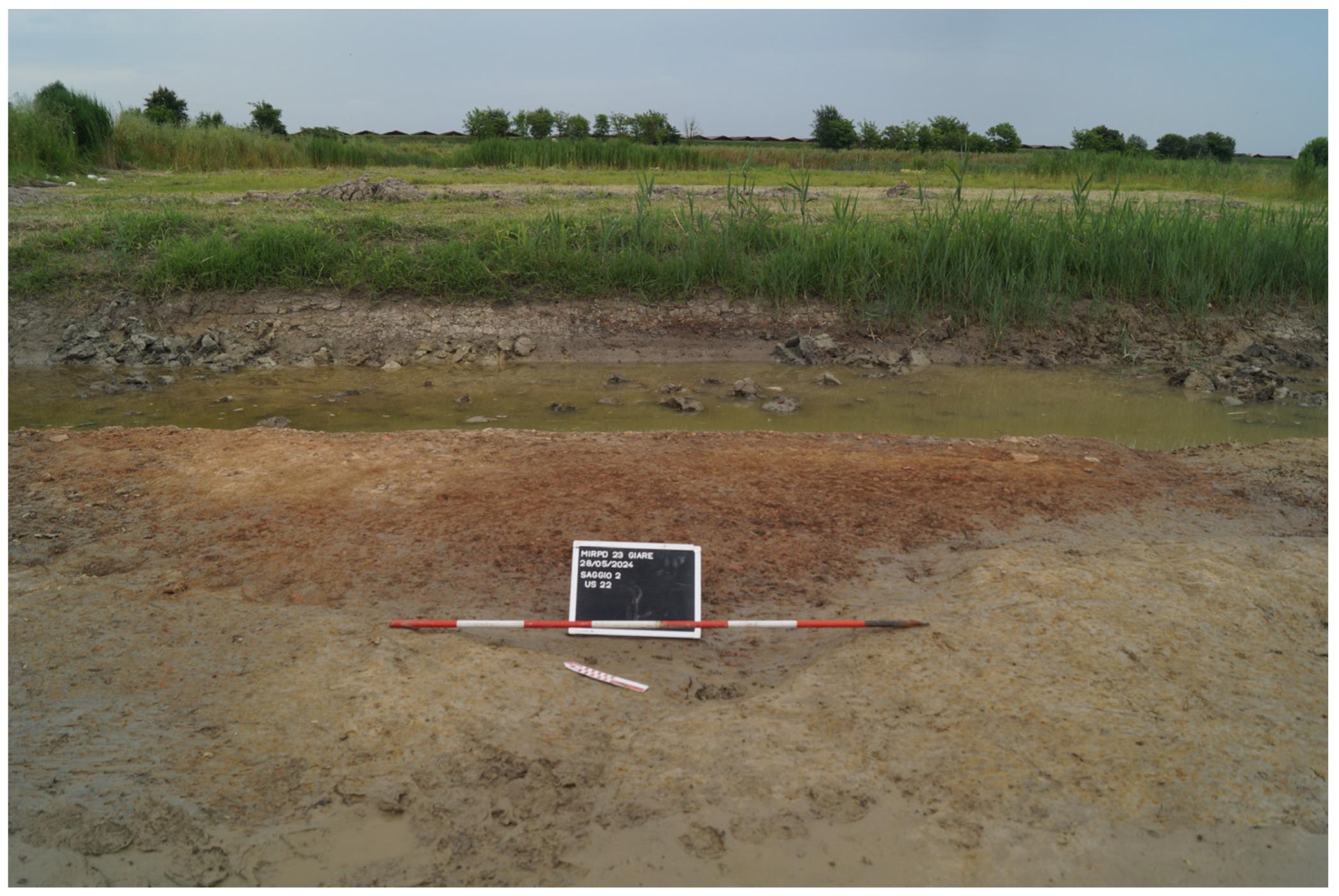
Two significant fired material concentrations were documented, the function of which is still under investigation: the first (SU 5), characterised by decimetric and centimetric vessel fragments, had well-defined boundaries (
Figure 8); the second (SU 22), more akin to a dump, was mostly characterised by significantly smaller fragments, with a chaotic arrangement and less-defined boundaries (
Figure 9). An in-depth excavation below the aforementioned layer exposed a pyro-technological structure (
Figure 10), with only the cut surviving. The collected data points to a small furnace, exhibiting a vague mushroom-like profile, characterised by a sub-circular combustion chamber (2.10 m diameter) and a long inlet channel/praefurnium (1.35 m in length).
The structure’s plan exhibits a characteristic configuration, comparable to a ‘keyhole’ or ‘fungoid’ shape, which finds a precise parallel in Type 3.1 as proposed by Agostino Sotgia [
38] (pp. 308–309). The furnace classified as Type 3.1 corresponds to a two-chambered structure with a horizontal development, wherein the combustion and firing chambers are arranged according to a figure-eight planimetric configuration. This furnace typology emerged starting from the Middle Bronze Age and continued to be used through the early Iron Age. The combustion chamber housed the fuel, while the artefacts to be fired were placed in the firing chamber. This technical principle, based on the utilisation of heat rather than direct flame, facilitated a more homogeneous firing of the artefacts and greater potential for controlling the internal atmosphere of the firing chamber. Draft, therefore, occurred horizontally.
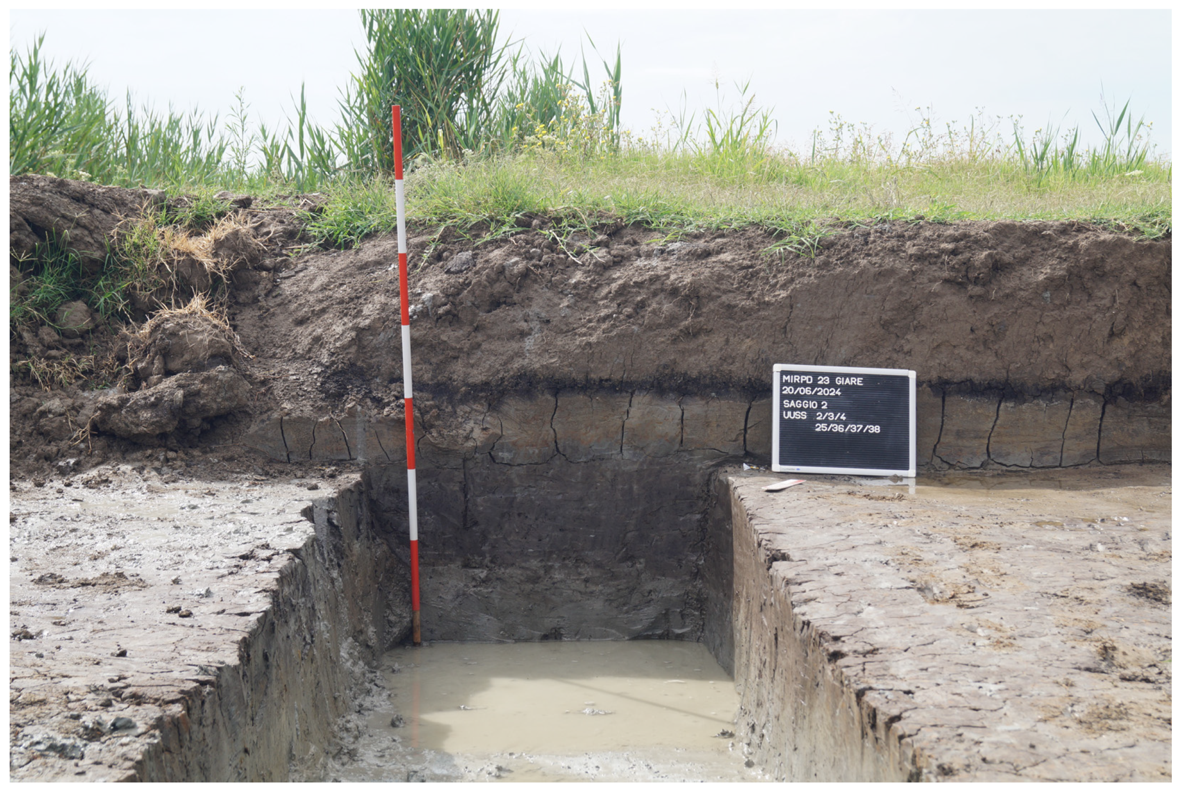
In the southern part of the archaeological test unit, a shallow channel/basin with stagnant water was identified. Due to its size, an in-depth transect was excavated (
Figure 7). Below the alluvial deposit (SU 4), a primary fill (SU 25) was observed, consisting of a rather compact clay–silt deposit, of plastic consistency, 30 cm thick, rich in peat-like vegetal material but lacking inorganic inclusions. Beneath this level, a deposit (SU 36) with a weakly silty clay matrix was distinguished, poorly compacted and with varying thickness, reaching 5 cm in some areas and absent in others. Rare inclusions of wood, ceramics, bone and malacofauna were present. This level likely represents a wet ground surface within the channel/basin, possibly the visible bottom during the period of the site’s activity. The layer’s irregular morphology may have been caused by repeated animal trampling. Continuing downwards, a compact clay deposit (SU 37) is recognised, 22 cm thick, containing horizontally oriented brushwood. The disposition of this material suggests the presence of stagnant water, confirming a natural formation at the bottom of the channel/basin. The absence of water flow facilitated the accumulation and stagnation of vegetal debris.
Finally, the bottom of the channel/basin was composed of a light-grey, weakly sandy clay matrix deposit (SU 38) with diffuse calcium carbonate concretions. This layer, also found in core drillings and at the base of the three excavated pits, likely represents the original ground surface upon which the archaeological site was established.
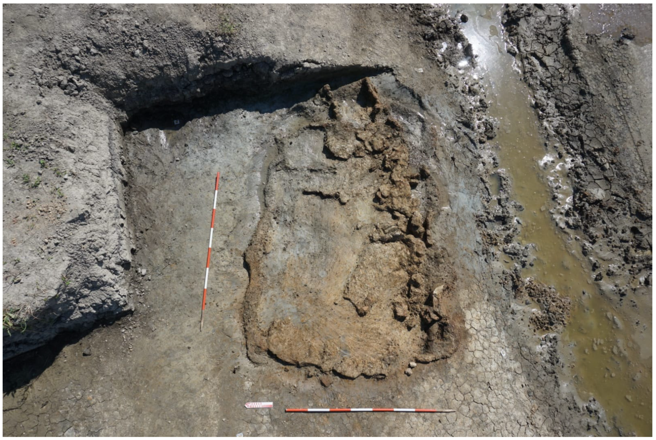
In Test Unit 1 (
Figure 4), the excavation uncovered a significant pyro-technological structure (2.5 m × 4.0 m), sub-rectangular in shape, with arched niches along its southern side. This structure cuts through an ancient ground surface (SU 505), consisting of a clay–silt matrix with fired clay fragments and sparse ceramics. Initially thought to be a furnace, the structure was found in good condition, with an intact perimeter curb and a side opening defined by curbs (
Figure 11). A small in-depth excavation within the structure revealed a charcoal deposit of approximately 20 cm. Given the unique nature of the find, a survey technique was chosen to balance site excavation timelines with research needs. The documentation phase was therefore integrated with a high-definition 3D scan, necessary for future detailed studies and also usable for promotional purposes.
Test Unit 3 (
Figure 4), located near Test Unit 1, yielded no structural remains. However, fragments of ceramic and fired clay vessels, along with sparse millimetric charcoal inclusions, were found scattered throughout the layer (SU 605 = SU 505) at the same level as the structure in Test Unit 1.
4.2. Geophysical Results
4.2.1. Electrical Resistivity Tomography
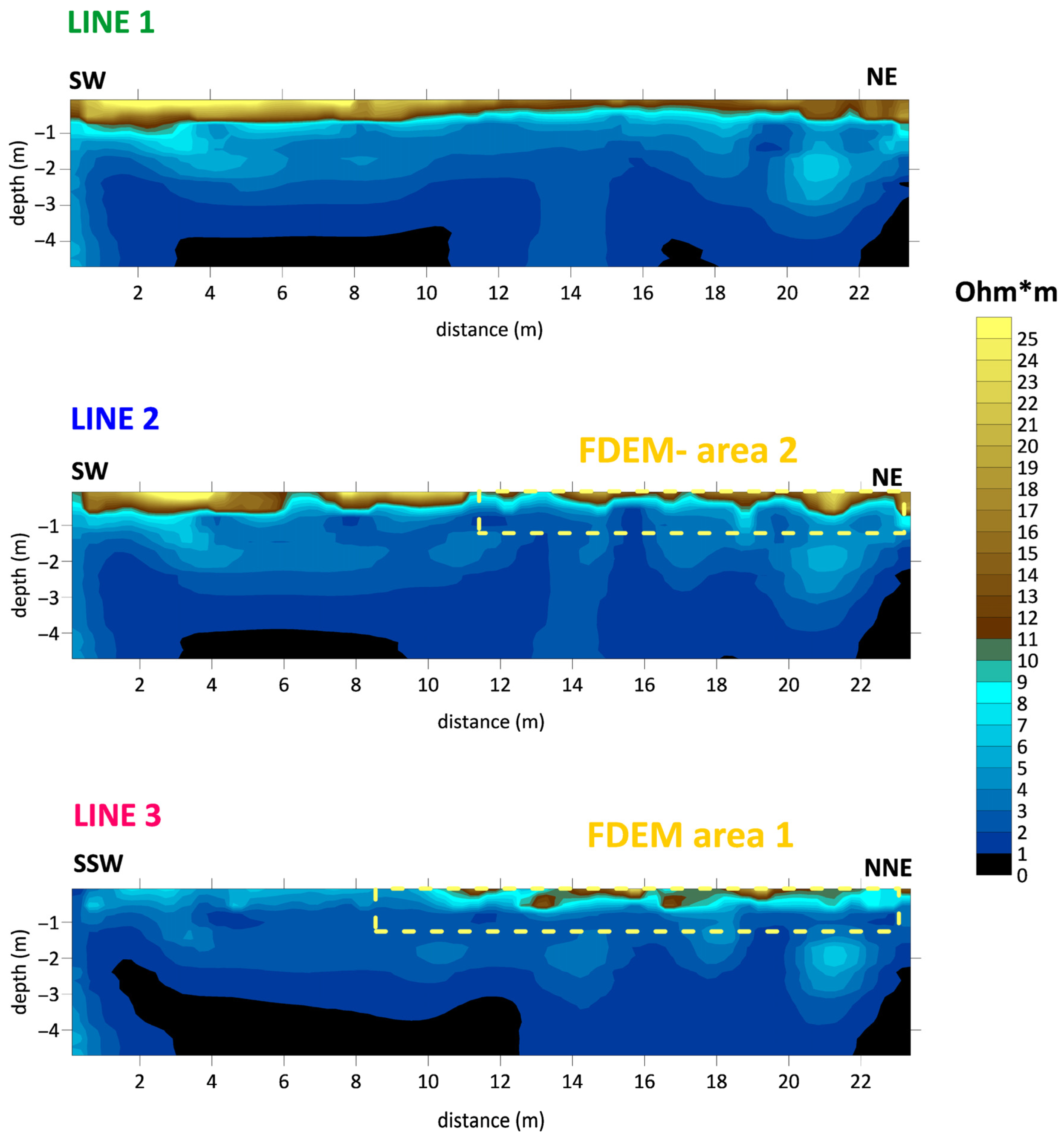
The results of the ERT measurements are shown in
Figure 12. The three ERT sections were made to analyse the relationship of the archaeological evidence with the deeper-buried geomorphological system present in the area. The resistivity range of each section appeared very similar and consistent, with values ranging between a minimum of 0 and maximums lying between 25 and 40 Ohm*m. Starting from these ranges, a common resistivity range of 0–25 Ohm*m was adopted to evaluate similar behaviours in the three sections. The outcome of checking the direct and reciprocal measurements is that 95% of the data on all sections is saved, defining the absolute goodness of the dataset and the validity of the recorded signal. Line 1, according to the scheme of acquisition of geophysical measurements shown in
Figure 5, appears outside the areas investigated with FDEM measurements. In contrast, Line 2 crosses NW area 2 investigated with FDEM measurements starting from metre 11 until the end of the line from south to north (yellow lines in
Figure 5). Line 3 crossed area 1 investigated with FDEM measurements to the SE in the portion from metre 9 and for the entire line length (yellow lines in
Figure 5). The analysis of the resistivity values obtained for the three sections, shown in
Figure 12, depicts the presence of more-resistive sediments in the shallow part of all three sections, with values ranging from 25 Ohm*m to 11 Ohm*m, distributed differently both laterally and in depth for each section over a band affecting the first metre from ground level.
In particular, where this more-surface-resistive level appears continuous, horizontal and homogeneous in Line 1, in Line 2, this layer appears irregular throughout the whole section. In contrast, in Line 3, this resistive layer seems to affect only the second part of the section, showing a more conductive zone even at the surface in the first portion of the line. The three deep sections show an expected increase in electrical conductivity (inverse of resistivity), albeit uneven, in the deepest part of all sections, with varying distributions for each. The most interesting area, however, seems to be the one with a thickness between 1 m and 3 m in depth above ground level (
Figure 12). In fact, in this area, we note the presence of a series of isolated bodies varying in colour between cyan and light blue, apparently related to similar structures (e.g., deposits of materials with larger grain sizes than the host system), considering the resistivity values and electrically conductive behaviour compared to the background. Lateral and vertical resistivity trends and the total number of these structures for each ERT section appear variable. Note that the apparent vertical effect of some anomalies, such as those visible between 10 m and 16 m in Line 1, around 14 m in Line 2 and less markedly between 12 m and 22 m in Line 3, is provided by the impossibility, within the maximum depth of investigation obtainable here, of fully resolving the geometry of deeper, not necessarily vertical, structures such as those described here.
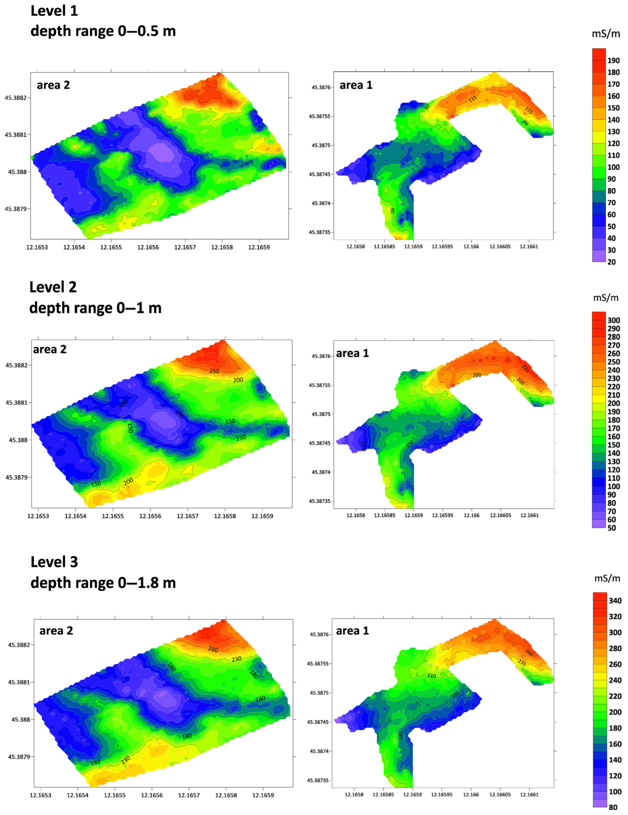
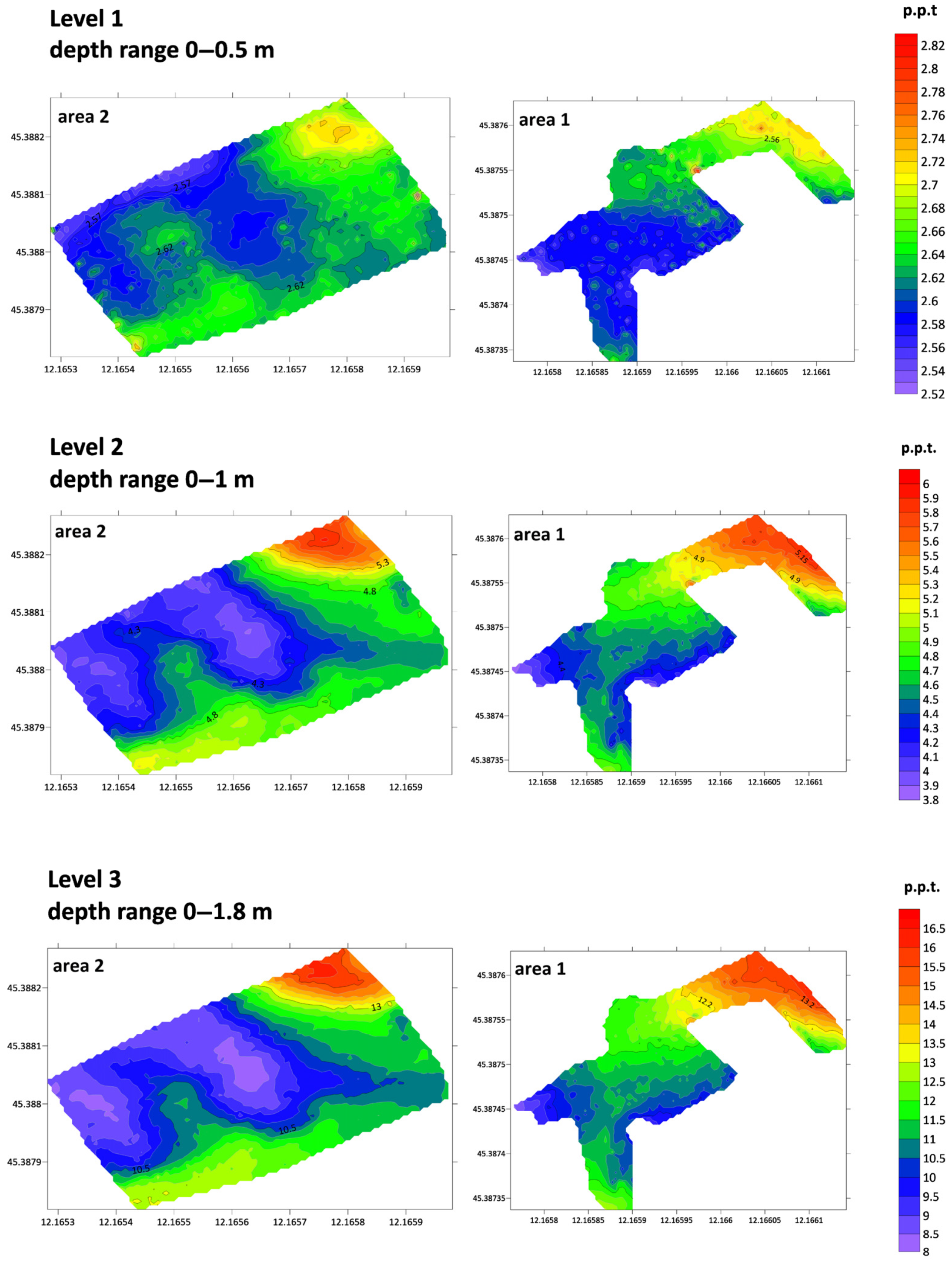
4.2.2. Frequency-Domain Electromagnetic Measurements
The FDEM measurements produced three different electrical conductivity maps and three maps of the magnetic behaviour of the system, corresponding to three different depth ranges, as shown in the images in
Figure 13 and
Figure 14.
For each depth range analysed, we decided to adopt a common range of values of the EM field component related to the electrical and magnetic behaviour of the system in the specific layer. The pattern of electrical conductivity in the three depth ranges investigated is consistent, with a significant increase in electrical conductivity values in the NE zone at all levels for both areas (red zones in the images in
Figure 13).
In the images related to the variation in the magnetic behaviour detectable through the in-phase component of the EM field in the same depth ranges considered for the electrical response, it is interesting to note that the pattern is consistent across levels. Also, for the in-phase maps, we adopted a common scale for both areas investigated for each level considered. In an analysis of the resulting maps, shown in
Figure 14, it is of extreme interest to note that the values of the parameter under investigation increased in the same areas (red) where we registered an increase in the electrical conductivity of the system (
Figure 13).
4.3. Core-Sample Analysis
Hard and compacted buried soil with a silty clay, grey matrix and many centimetre-size carbonatic nodules were found in the lower part of most cores. The cross-section of
Figure 15 shows the lateral extension of this soil, on which the archaeological deposits lie. Above the archaeological deposits and the buried soil, there are clay sediments that are topped by a peat layer. The sedimentary succession is closed at the top by an extensive unit of silty sand. These latter sediments are connected with a sandy palaeochannel located in the central portion of the section, whose erosive base cuts older sedimentary units.
5. Discussion
Geographically, the site is situated within a liminal zone between the mainland and the lagoon basin, exhibiting conditions of hydro-geological instability and marginality vis-à-vis the principal settlement agglomerations thus far identified predominantly within the northern sector of the Venice lagoon. This location, coupled with the good state of preservation of the archaeological levels and the absence of significant post-depositional disturbances, has enabled the recognition of a complex stratigraphic palimpsest, yielding material evidence that offers significant new insights on human presence and productive activities in the central sector of the Venice lagoon during the protohistoric period.
The totality of the material and stratigraphic data allows for the assignment of the site to a phase dating between the late Recent Bronze Age 2 (first half of the 12th century BCE) and the early Final Bronze Age 1–2 (1175/50-1000 BCE). The recovered evidence—including two pyro-technological structures, extensive concentrations of fired clay materials and three potential basins containing refined clays—clearly indicates the artisanal and productive nature of the site, likely specialised in ceramic manufacture or the transformation of raw materials (possibly also lagoon resources such as fish or salt, a hypothesis currently under analytical verification). The typo-chronological and functional study of artefacts and structures is currently ongoing, and thus, both hypotheses remain open at this time.
The eminently productive connotation of the structural evidence uncovered during excavation, the scarcity of domestic pottery and the marked disproportion of the latter in relation to the large quantity of collected fired clay materials underscore the non-residential nature of the site. The settlement associated with the unearthed artisanal site was likely located in the vicinity, at a distance easily traversable on foot, allowing for the convenient monitoring of ongoing production processes and an easy return to dwellings at the conclusion of work activities, with minimal (or no) on-site consumption of meals.
ERT measurements conducted through three different 2D vertical sections at the Giare site around the two excavated areas provide interesting data for evaluating the ancient lagoon hydrologic system on which the archaeological site is set. In fact, in addition to a more shallow resistive system that seems to affect the first metre of depth below the present ground level, the ERT sections show the presence of an evident lateral and vertical variability between 1 m and 3 m depth, identifying selected areas with different resistivity values as zones of the accumulation of materials with different grain sizes (e.g., palaeochannels).
FDEM measurements combined with ERT measurements provided a clear and expected correlation with the more shallow palaeochannel system, also visible in traces from satellite imagery and likely corresponding to recent historical ages, given the maximum depth of investigation obtained here of about 1.5 m from ground level. The EM field’s quadrature and in-phase component maps agree, respectively, in detecting anomalous increases in the electrical conductivity and magnetic behaviour of the system over two specific areas. The high conductivity supports the possibility of a buried layer with an anomalous salt concentration in a specific zone in these areas. On the other hand, fire clay materials and specific remains associated with pyro-technological activities represent a potential perfect magnetic target, producing anomalies in the in-phase component of the EM field, thus revealing their possible concentration in the actual subsoil.
The buried soil identified in the cores (
Figure 15) is interpreted as being the caranto palaeosoil, developed on top of the LGM succession of the Brenta megafan. The topographic surface on which the productive site was settled corresponds to the top of the soil. From a palaeoenvironmental point of view, the pronounced soil evolution shows that the site was a relict, stable, relatively well-drained alluvial plain. The site was lying at a distance of about 3.7 km from the Bronze Age lagoon margin and 3.5 km from the then-active Brenta River channel (
Figure 2).
The archaeological site was buried by fine-grained floodplain deposits. These deposits are related to distal overbank flooding by a major river, presumably the nearby Bronze Age Brenta River. The good preservation of the archaeological structure buried by fluvial sediments suggests that the site was abandoned not long before sedimentation started.
The peat layer can tentatively be correlated with the peat that was found in cores carried few hundred metres NW of the study area, and that was radiocarbon-dated to the Middle Ages [
39]. This implies that peat deposition corresponds to a rather long period comprising the Iron Age, Roman times and early part of the Middle Ages. The final burial of the peat by the sandy silty deposits is attributed to proximal overbank deposition by the Brenta palaeochannel that was crossing the area in medaieval times.
6. Conclusions and Future Perspectives
The intervention of rescue archaeology, planned during water restoration works in the Giare–Mira area between 2023 and 2024, opened an important window into human activities in the Bronze Age at the edge of the central-southern Venice lagoon. The approach to studying this context was undoubtedly conditioned by the logistical limitations and time constraints imposed by the water restoration works. However, the fortunate possibility of collecting geophysical and geomorphological information, in addition to the important and unexpected archaeological structures found in the only three excavation assays carried out in the area, makes it possible to formulate new preliminary hypotheses on the occupation of this site since the Bronze Age.
To further investigate the site, various samples were collected for planned laboratory analyses during the excavation process. Specifically, to reconstruct the ancient environment, palynological analysis of soil samples and archaeobotanical analysis of plant macro-remains (including combusted remnants from the suspected furnaces) are scheduled. To refine the chronological data derived from vessel typologies, radiocarbon dating of organic materials is planned. To evaluate the site’s potential primary function in processing lagoon products (fish/salt), biochemical analyses will be conducted on the internal surfaces of fired clay artefacts to identify markers of relevant biological products. Lastly, archaeometric analyses of both fired clay and ceramic vessels are slated to determine the artefacts’ firing and usage temperatures.
To delineate the spatial extent of the habitation likely affiliated with the exposed protohistoric production site, a comprehensive, multi-scalar investigation of the encompassing area (c. 860 ha) is programmed, with initial emphasis on its detection. This analysis will proceed through sequential tiers of inquiry. The primary stage will entail the examination of historical cartographic sources and the application of aerial photographic interpretation to identify anthropogenic anomalies, leading to the creation of a predictive archaeological sensitivity map. Informed by the resultant dataset, a subsequent phase of systematic surface reconnaissance will be implemented, concentrating on the on-the-ground verification of the most archaeologically significant anomalies. The outcomes of the surface surveys will inform the subsequent in-depth phase, comprising a programme of geophysical prospection and mechanical coring aimed at the precise definition of the identified archaeological sites, determining their horizontal extent and the depth of archaeological horizons relative to the present ground level.
Author Contributions
Conceptualisation, C.R., G.A.G., P.M. (Paolo Mozzi) and S.P.; methodology, C.R. and G.A.G.; software, L.P., I.B., P.M. (Pietro Maniero) and S.R.; validation, C.R., R.D., P.M. (Paolo Mozzi) and S.P.; investigation, R.D., I.B., L.P., G.A.G., S.R., P.M. (Pietro Maniero) and A.d.L.; resources, C.R.; data curation, I.B. and L.P.; writing—original draft preparation, C.R., G.A.G., P.M. (Paolo Mozzi) and S.P.; writing—review and editing, C.R., G.A.G., P.M. (Paolo Mozzi) and S.P.; supervision, C.R., G.A.G., P.M. (Paolo Mozzi) and S.P.; project administration, C.R. and S.D.S.; funding acquisition, C.R. All authors have read and agreed to the published version of the manuscript.
Funding
This research was funded by Italian Ministry of Culture (MiC)—Soprintendenza Archeologia, Belle Arti e Paesaggio per il Comune di Venezia e Laguna (archeologia preventiva nella Laguna Sud—Programmazione triennale dei lavori pubblici 2024–2026. D.M. n. 327 del 20 ottobre 2023).
Data Availability Statement
The data will be made available on request to authors.
Acknowledgments
This research was supported by the World Class Research Infrastructure (WCRI) SYCURI—SYnergic strategies for CUltural heritage at RIsk—and fully funded by the University of Padova.
Conflicts of Interest
Gaia Alessandra Garosi, Alessandro de Leo and Stefano Di Stefano are employed by the Se.Arch. Srl. The authors declare no conflicts of interest. The funders had no role in the design of the study; in the collection, analyses, or interpretation of data; in the writing of the manuscript; or in the decision to publish the results.
References
- Cupitò, M.; Leonardi, G. Il Veneto tra Bronzo Antico e Bronzo Recente. In Preistoria e Protostoria del Veneto; Leonardi, G., Tiné, V., Eds.; Istituto Italiano di Preistoria e Protostoria: Florence, Italy, 2015; pp. 201–239. ISBN 978-88-6045-056-2. [Google Scholar]
- Cupitò, M.; Lotto, D.; Facchin, A. Dinamiche di popolamento e modelli di organizzazione del territorio nella bassa pianura veneta compresa tra Adige e Tagliamento durante l’Età del bronzo. In Preistoria e Protostoria del Veneto, Studi di Preistoria e Protostoria, 2; Leonardi, G., Tiné, V., Eds.; Istituto Italiano di Preistoria e Protostoria: Rome, Italy, 2015; pp. 295–306. [Google Scholar]
- Bagolan, M.; Leonardi, G. Il bronzo finale nel Veneto. In Il Protovillanoviano al di qua e al di là dell’Appennino”, Biblioteca di Athenaeum 38; Harari, M., Pearce, M., Eds.; Athenaeum Editrice: Pavia, Italy, 2000; pp. 13–44. [Google Scholar]
- Bianchin Citton, E. Il sito umido di S. Gaetano—Casa Zucca. In La Protostoria tra Sile e Tagliamento. Antiche Genti tra Veneto e Friuli, Catalogo della Mostra; Concordia Sagittaria, 14 settembre–10 novembre 1996; Pordenone, 23 novembre 1996–8 gennaio 1997; Esedra: Padua, Italy, 1996; pp. 175–185. [Google Scholar]
- Fontana, A.; Vinci, G.; Tasca, G.; Mozzi, P.; Vacchi, M.; Bivi, G.; Salvador, S.; Rossato, S.; Antonioli, F.; Asioli, A.; et al. Lagoonal settlements and relative sea level during Bronze Age in Northern Adriatic: Geoarchaeological evidence and paleogeographic constraints. Quat. Int. 2017, 439, 17–36. [Google Scholar] [CrossRef]
- Malizia, A. La raccolta paletnologica del Museo Archeologico di Altino (Venezia). Archeol. Veneta 1985, 8, 125–148. [Google Scholar]
- Citton, E. L’abitato del Bronzo finale e degli inizi dell’età del ferro di Portegrandi nella tenuta I Marzi. In Altino Antica. Dai Veneti a Venezia; Tirelli, M., Ed.; Marsilio: Venice, Italy, 2011; pp. 50–51. [Google Scholar]
- Barbero, S.R.; Albani, A.; Zecchetto, S. Palaeoenvirnmental significance of a benthis foraminifera fauna from and archaeological excavation in the Lagoon of Venice. Palaeogeogr. Palaeoclimatol. Palaeoecol. 1997, 136, 27–34. [Google Scholar] [CrossRef]
- Ammerman, A.J.; McClennen, C.E.; De Min, M.; Housley, R. Sea level change and the archaeology of early Venice. Antiquity 1999, 73, 303–312. [Google Scholar] [CrossRef]
- Bondesan, A.; Meneghel, M. Geomorfologia della Provincia di Venezia: Note Illustrative della Carta Geomorfologica della Provincia di Venezia; Esedra: Padua, Italy, 2004. [Google Scholar]
- Moine, C.; Corrò, E.; Primon, S. Paesaggi Artificiali a Venezia. Archeologia e Geologia nelle terre del Monastero di Sant’Ilario tra alto Medioevo ed Età Moderna; All’Insegna del Giglio: Florence, Italy, 2017; ISBN 9788878147768. [Google Scholar]
- Mozzi, P.; Bini, C.; Zilocchi, L.; Becattini, R.; Mariotti Lippi, M. Stratigraphy, palaeopedology and palinology of late Pleistocene and Holocene deposits in the landward sector of the lagoon of Venice (Italy), in relation to caranto level. Alp. Mediterr. Quat. 2003, 16, 193–210. [Google Scholar]
- Donnici, S.; Serandrei Barbero, R.; Bini, C.; Bonardi, M.; Lezziero, A. The Caranto Paleosol and Its Role in the Early Urbanisation of Venice. Geoarchaeology 2011, 26, 514–543. [Google Scholar] [CrossRef]
- Tosi, L.; Rizzetto, F.; Bonardi, M.; Donnici, S.; Serandrei Barbero, R.; Toffoletto, F. Note Illustrative della Carta Geologica d’Italia alla Scala 1:50.000; 148–149—Chioggia-Malamocco; APAT, Dipartimento Difesa del Suolo, Servizio Geologico d’Italia: Rome, Italy, 2007. [Google Scholar]
- Pacciarelli, M. Dal villaggio alla città. La svolta protourbana del 1000 a.C. nell’Italia tirrenica. In Grandi Contesti e Problemi della Protostoria Italiana; All’Insegna del Giglio: Florence, Italy, 2001; Volume 4. [Google Scholar]
- Cardarelli, A. The collapse of the Terramare Culture and growth of new economic and social systems during the Late Bronze Age in Italy. Sci. Antich. 2009, 15, 449–520. [Google Scholar]
- Leonardi, G. Il Bronzo finale nell’Italia nord-orientale. Proposte per una suddivisione in fasi. In Il Bronzo Finale in Italia: Atti della XXI Riunione Scientifica; Istituto Italiano di Preistoria e Protostoria: Florence, Italy, 1979; pp. 155–188. [Google Scholar]
- Narkhov, E.; Muravyev, L.; Sergeev, V.; Fedorov, A.; Denisov, A.Y.; Shirokov, A.; Sapunov, V. Applications of modern high-precision Overhauser magnetometers. In AIP Conference Proceedings, Proceedings of the International Conference on Astronomy & Geophysics in Mongolia, Ulaanbaator, Mongolia, 20–22 July 2017; AIP Publishing LLC: Melville, NY, USA, 2017; Volume 1886, p. 20075. [Google Scholar] [CrossRef]
- Shaar, R.; Tauxe, L.; Ron, H.; Ebert, Y.; Zuckerman, S.; Finkelstein, I.; Agnon, A. Large geomagnetic field anomalies revealed in Bronze to Iron Age archeomagnetic data from Tel Megiddo and Tel Hazor, Israel. Earth Planet. Sci. Lett. 2016, 442, 173–185. [Google Scholar] [CrossRef]
- von der Osten-Woldenburg, H.; Chaume, B.; Reinhard, W. Magnetic imaging of a late Bronze Age tumulus in France before and during excavation. Lead. Edge 2002, 21, 465–466. [Google Scholar] [CrossRef]
- Kuna, M.; Křivánek, R.; Chvojka, O.; Šálková, T. A quantitative approach to magnetometer survey data: The case of the Late Bronze Age site of Březnice. J. Archaeol. Sci. 2021, 126, 105298. [Google Scholar] [CrossRef]
- Benech, C. Contribution of geophysics to the research on city planning in ancient and classical Near East. In Proceedings of the 11th International Conference for Archaeological Prospection, Warsaw, Poland, 15–19 September 2015; pp. 161–165. [Google Scholar]
- Fedorova, N.; Noskevich, V. Geophysical Investigations of the Bronze Age Archaeological Site in the Trans-Urals, Russia. In Recent Research on Geomorphology, Sedimentology, Marine Geosciences and Geochemistry; Springer: Cham, Switzerland, 2022. [Google Scholar] [CrossRef]
- Lowe, K.; Fogel, A.; Sneddon, A. Archaeological geophysical survey of a Prehistoric Bronze Age site in Cyprus (Alambra Mouttes)—Applications and limitations. Archaeol. Anthropol. Sci. 2018, 10, 1971–1989. [Google Scholar] [CrossRef]
- Persico, R.; Colica, E.; Zappatore, T.; Giardino, C.; D’Amico, S. Ground-Penetrating Radar and Photogrammetric Investigation on Prehistoric Tumuli at Parabita (Lecce, Italy) Performed with an Unconventional Use of the Position Markers. Remote Sens. 2022, 14, 1280. [Google Scholar] [CrossRef]
- Ulrich, B.; Günther, T.; Rücker, C. Electrical Resistivity Tomography Methods for Archaeological Prospection. In Layers of Perception, Proceedings of the 35th International Conference on Computer Applications and Quantitative Methods in Archaeology (CAA), Berlin, Germany, 2–6 April 2007; Posluschny, A., Lambers, K., Herzog, I., Eds.; Dr. Rudolf Habelt GmbH: Bonn, Germany, 2007. [Google Scholar]
- Parsi, M.; Linck, R.; Fassbinder, J.; Eitel, M. Highlighting the Potential of 3D ERT by Comparing its Results with GPR and the Excavation Map of a Roman Building. ArchéoSciences 2021, 45-1, 183–186. [Google Scholar] [CrossRef]
- Russolillo, A.; Martin, F.F.; Merico, A.; Sapia, V.; Talamo, P.; Materni, V.; Pischiutta, M.; De Vita, S.; Furlani, S.; Targia, D.; et al. Unveiling a hidden fortification system at “Faraglioni” Middle Bronze Age Village of Ustica Island (Palermo, Italy) through ERT and GPR prospections. J. Appl. Geophys. 2023, 220, 105272. [Google Scholar] [CrossRef]
- De Smedt, P.; Van Meirvenne, M.; Saey, T.; Baldwin, E.; Gaffney, C.; Gaffney, V. Unveiling the prehistoric landscape at Stonehenge through multi-receiver EMI. J. Archaeol. Sci. 2014, 50, 16–23. [Google Scholar] [CrossRef]
- Mele, M.; Cremaschi, M.; Giudici, M.; Lozej, A.; Pizzi, C.; Bassi, A. The Terramare and the surrounding hydraulic structures: A geophysical survey of the Santa Rosa site at Poviglio (Bronze Age, northern Italy). J. Archaeol. Sci. 2013, 40, 4648–4662. [Google Scholar] [CrossRef]
- Deiana, R.; Vicenzutto, D.; Deidda, G.P.; Boaga, J.; Cupitò, M. Remote Sensing, Archaeological, and Geophysical Data to Study the Terramare Settlements: The Case Study of Fondo Paviani (Northern Italy). Remote Sens. 2020, 12, 2617. [Google Scholar] [CrossRef]
- Cassiani, G.; Bellizia, E.; Fontana, A.; Boaga, J.; D’Alpaos, A.; Ghinassi, M. Geophysical and Sedimentological Investigations Integrate Remote-Sensing Data to Depict Geometry of Fluvial Sedimentary Bodies: An Example from Holocene Point-Bar Deposits of the Venetian Plain (Italy). Remote Sens. 2020, 12, 2568. [Google Scholar] [CrossRef]
- Benech, C.; Lombard, P.; Rejiba, F.; Tabbagh, A. Demonstrating the contribution of dielectric permittivity to the in-phase EMI response of soils: Example from an archaeological site in Bahrain. Near Surf. Geophys. 2016, 14, 337–344. [Google Scholar] [CrossRef]
- Simpson, D.; Meirvenne, M.; Lück, E.; Bourgeois, J.; Joerg, R. Prospection of two circular Bronze Age ditches with multi-receiver electrical conductivity sensors (North Belgium). J. Archaeol. Sci. 2010, 37, 2198–2206. [Google Scholar] [CrossRef]
- De Smedt, P.; Meirvenne, M.; Meerschman, E.; Saey, T.; Bats, M.; Court-Picon, M.; De Reu, J.; Zwertvaegher, A.; Antrop, M.; Bourgeois, J.; et al. Reconstructing Palaeochannel Morphology with a Mobile Multicoil Electromagnetic Induction Sensor. Geomorphology 2011, 130, 136–141. [Google Scholar] [CrossRef]
- De Smedt, P.; Saey, T.; Lehouck, A.; Stichelbaut, B.; Meerschman, E.; Islam, M.M.; Van De Vijver, E. Exploring the potential of multi-receiver EMI survey for geoarchaeological prospection: A 90ha dataset. Geoderma 2013, 199, 30. [Google Scholar] [CrossRef]
- LaBrecque, D.J.; Morelli, G.; Daily, W.; Ramirez, A.; Lundegard, P. Occam’s inversion of 3D ERT data. In Three-Dimensional Electromagnetics; Spies, B., Ed.; SEG: Tulsa, OK, USA, 1999; pp. 575–590. [Google Scholar]
- Sotgia, A. Fornaci per ceramica ed aree produttive in Italia tra Età del Bronzo ed Età del Ferro. IpoTESI Preistoria 2019, 12, 301–318. [Google Scholar] [CrossRef]
- Bondesan, A.; Primon, S.; Bassan, V.; Vitturi, A. Le unità Geologiche della Provincia di Venezia; Cierre Grafica, Report; Cierre Grafica: Sommacampagna, Italy, 2008. [Google Scholar]
Figure 1.
Position of Mira-Giare site (red circle) in the lagoon of Venice (Google Earth image modified by authors).
Figure 1.
Position of Mira-Giare site (red circle) in the lagoon of Venice (Google Earth image modified by authors).
Figure 2.
Geomorphological sketch map of the area around the Giare site [
5,
11,
14].
Figure 2.
Geomorphological sketch map of the area around the Giare site [
5,
11,
14].
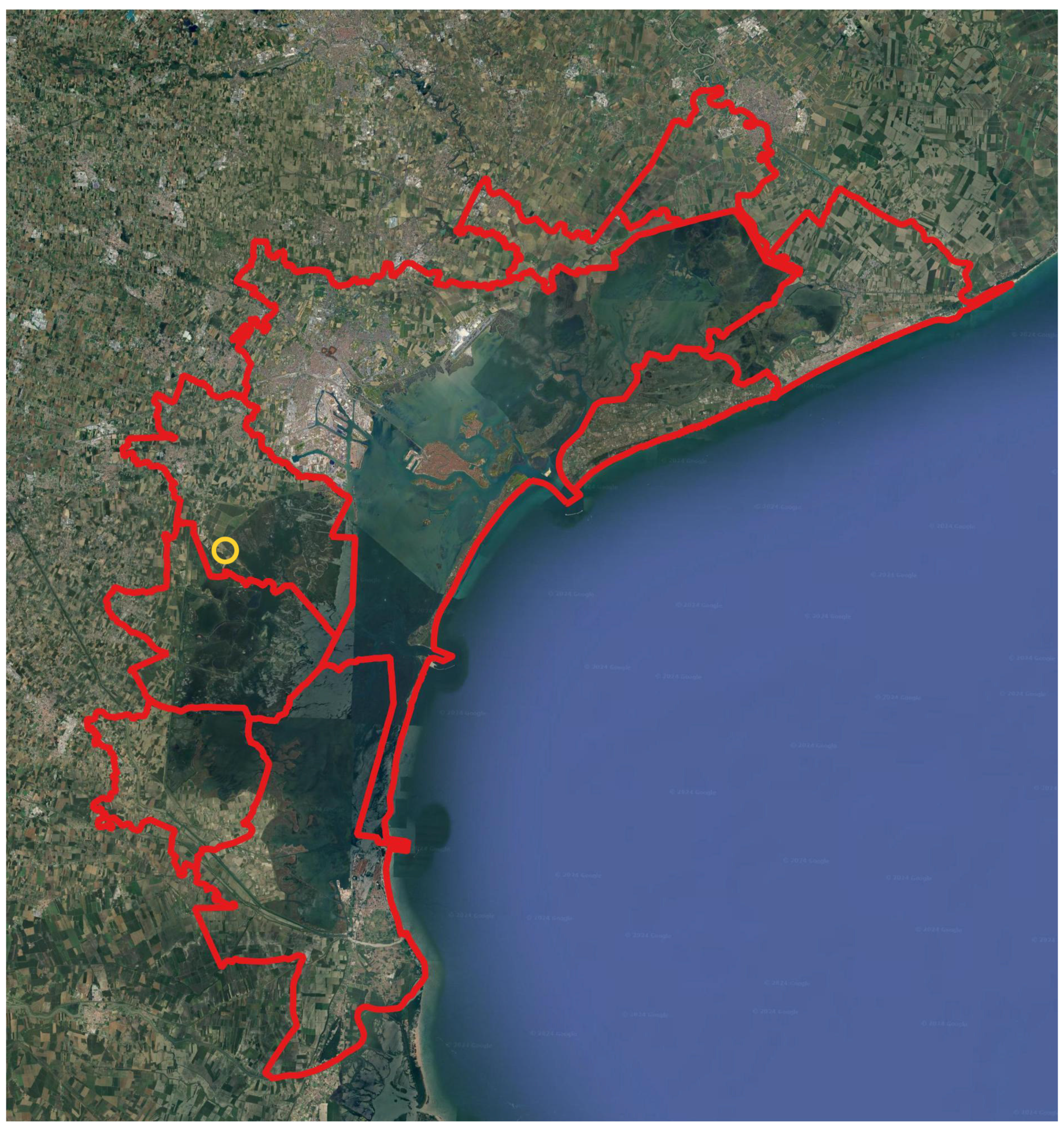
Figure 3.
Territory under the jurisdiction of the Soprintendenza Archeologia, Belle Arti e Paesaggio per il Comune di Venezia e Laguna (red line indicates the perimeter of the municipalities). The location of the site is highlighted with a yellow circle (Google Earth image modified by authors).
Figure 3.
Territory under the jurisdiction of the Soprintendenza Archeologia, Belle Arti e Paesaggio per il Comune di Venezia e Laguna (red line indicates the perimeter of the municipalities). The location of the site is highlighted with a yellow circle (Google Earth image modified by authors).
Figure 4.
Mira (Venice), site plan of Parco delle Giare with location of archaeological stratigraphic tests (1, 2, 3 in the figure) (Google Earth image modified by authors).
Figure 4.
Mira (Venice), site plan of Parco delle Giare with location of archaeological stratigraphic tests (1, 2, 3 in the figure) (Google Earth image modified by authors).
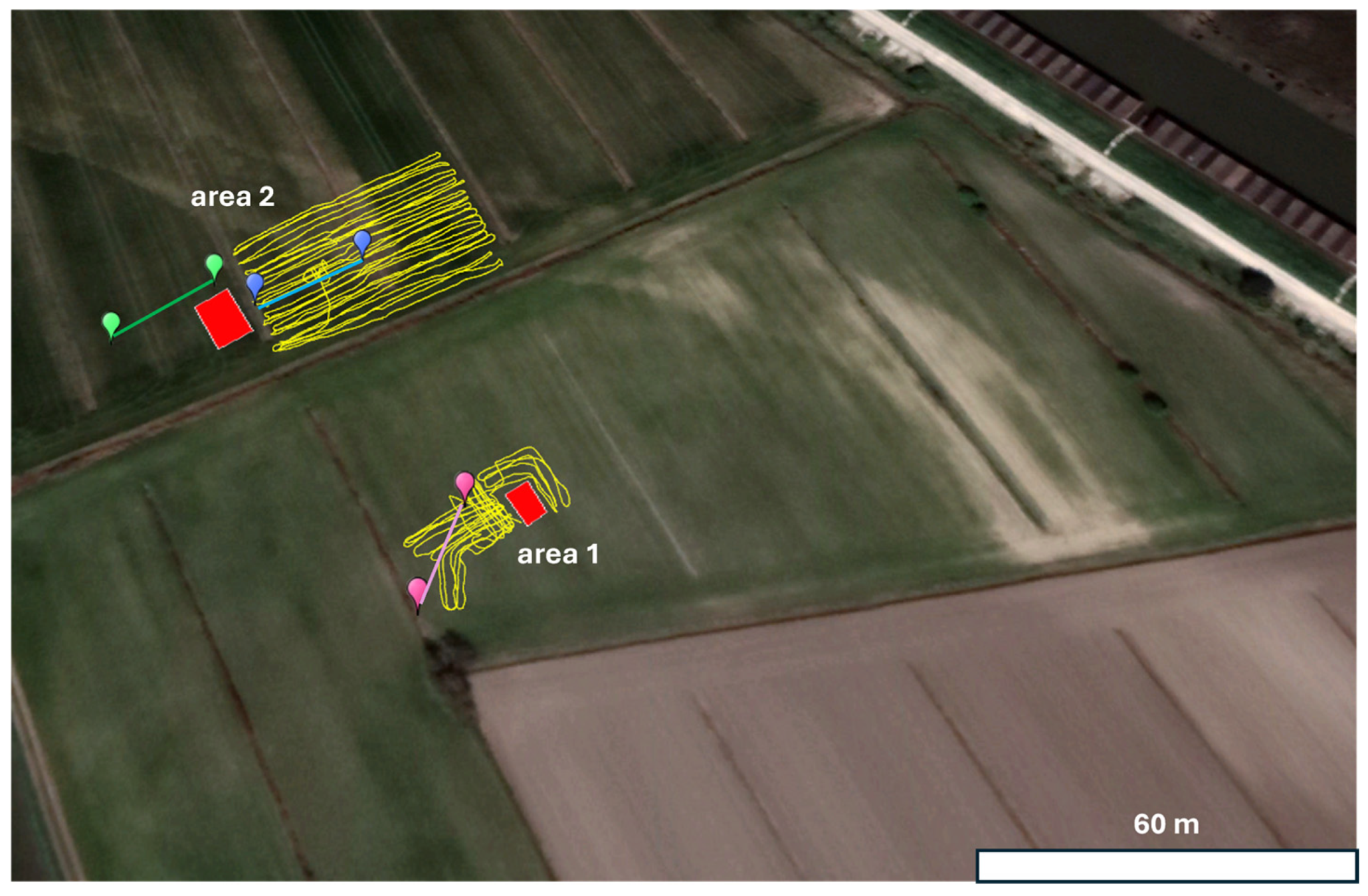
Figure 5.
Locations of the FDEM measurements (yellow lines) and ERT lines (green, blue and pink) in the two excavated areas in red.
Figure 5.
Locations of the FDEM measurements (yellow lines) and ERT lines (green, blue and pink) in the two excavated areas in red.
Figure 6.
Location of geological cores.
Figure 6.
Location of geological cores.
Figure 7.
Mira (Venice), Parco delle Giare. Southern section of the in-depth transect in the channel/basin identified in Test Unit 2 (Photo: Se.Arch. Srl—Courtesy of SABAP VE-Lag).
Figure 7.
Mira (Venice), Parco delle Giare. Southern section of the in-depth transect in the channel/basin identified in Test Unit 2 (Photo: Se.Arch. Srl—Courtesy of SABAP VE-Lag).
Figure 8.
Mira (Venice), Parco delle Giare. Concentration of fired clay fragments in Test Unit 2 (Photo: Se.Arch. Srl—Courtesy of SABAP VE-Lag).
Figure 8.
Mira (Venice), Parco delle Giare. Concentration of fired clay fragments in Test Unit 2 (Photo: Se.Arch. Srl—Courtesy of SABAP VE-Lag).
Figure 9.
Mira (Venice), Parco delle Giare. Disordered deposit of fired clay fragments in Test Unit 2 (Photo: Se.Arch. Srl—Courtesy of SABAP VE-Lag).
Figure 9.
Mira (Venice), Parco delle Giare. Disordered deposit of fired clay fragments in Test Unit 2 (Photo: Se.Arch. Srl—Courtesy of SABAP VE-Lag).
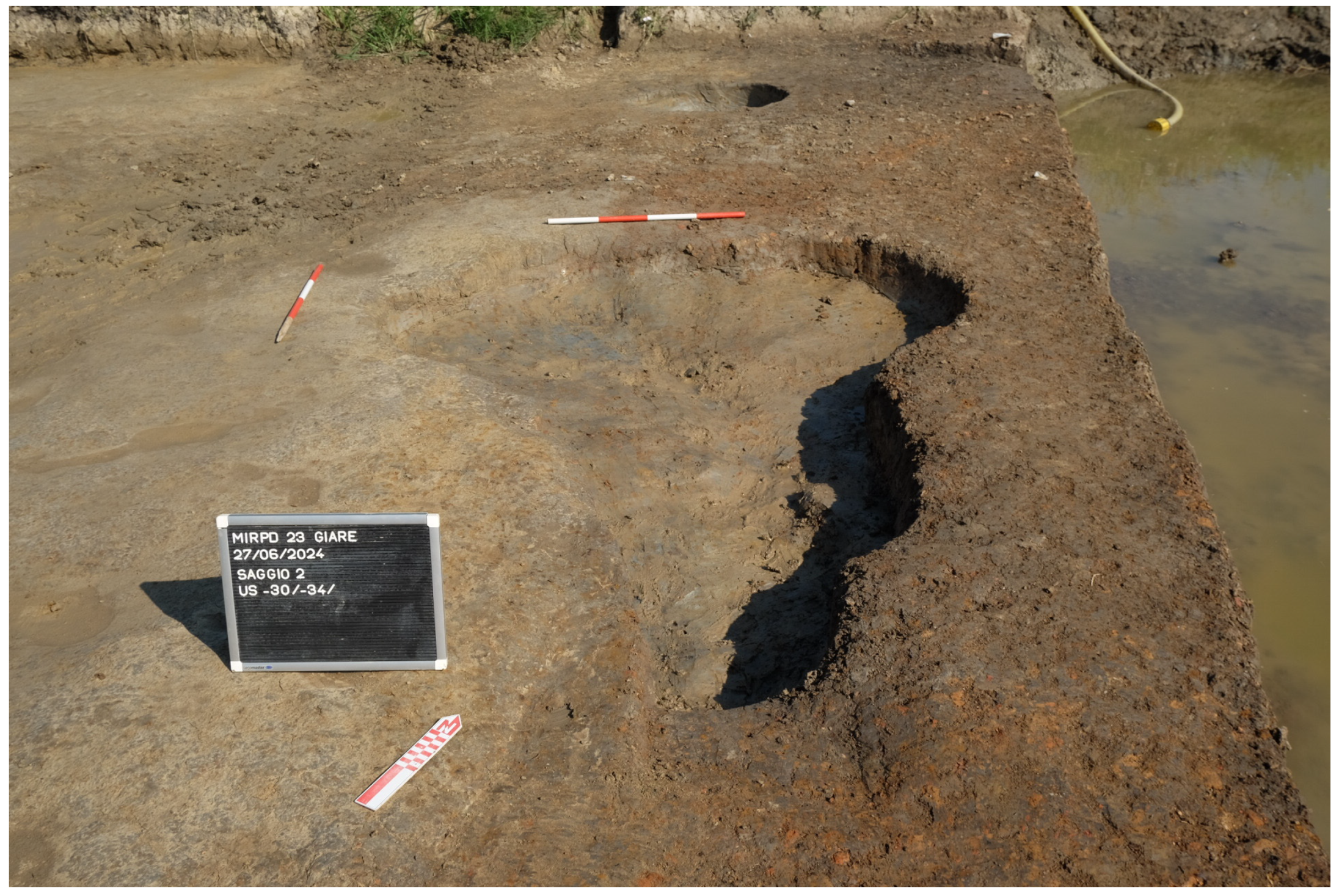
Figure 10.
Mira (Venice), Parco delle Giare. Structure cut identified in Test Unit 2 (Photo: Se.Arch. Srl—Courtesy of SABAP VE-Lag).
Figure 10.
Mira (Venice), Parco delle Giare. Structure cut identified in Test Unit 2 (Photo: Se.Arch. Srl—Courtesy of SABAP VE-Lag).
Figure 11.
Mira (Venice), Parco delle Giare. Pyro-technological structure identified in Test Unit 1 (Photo: Se.Arch. Srl—Courtesy of SABAP VE-Lag).
Figure 11.
Mira (Venice), Parco delle Giare. Pyro-technological structure identified in Test Unit 1 (Photo: Se.Arch. Srl—Courtesy of SABAP VE-Lag).
Figure 12.
Results of the inversion processing of the three ERT lines (green, blue and pink lines in
Figure 5).
Figure 12.
Results of the inversion processing of the three ERT lines (green, blue and pink lines in
Figure 5).
Figure 13.
Results of FDEM measurements corresponding to the electrical conductivity at the three different investigated depth range levels.
Figure 13.
Results of FDEM measurements corresponding to the electrical conductivity at the three different investigated depth range levels.
Figure 14.
Results of FDEM measurements corresponding to the magnetic susceptibility at the three different investigated depth range levels.
Figure 14.
Results of FDEM measurements corresponding to the magnetic susceptibility at the three different investigated depth range levels.
Figure 15.
Geological section (for location of the cores, see
Figure 6). The archaeological deposits at the SE end of the section correspond to the excavated archaeological site.
Figure 15.
Geological section (for location of the cores, see
Figure 6). The archaeological deposits at the SE end of the section correspond to the excavated archaeological site.
| Disclaimer/Publisher’s Note: The statements, opinions and data contained in all publications are solely those of the individual author(s) and contributor(s) and not of MDPI and/or the editor(s). MDPI and/or the editor(s) disclaim responsibility for any injury to people or property resulting from any ideas, methods, instructions or products referred to in the content. |
© 2025 by the authors. Licensee MDPI, Basel, Switzerland. This article is an open access article distributed under the terms and conditions of the Creative Commons Attribution (CC BY) license (https://creativecommons.org/licenses/by/4.0/).


 ,
, 
