1. Introduction
Cities across the globe are undergoing unprecedented socio-ecological transformations driven by the intersecting forces of climate change, rapid urbanisation, and biodiversity loss [
1,
2,
3,
4]. In the United Kingdom, these pressures are further complicated by a legacy of post-industrial urban form, socio-spatial inequality, and fragmented ecological networks [
5,
6]. As urban populations grow and densify, so too do the challenges of managing stormwater, mitigating urban heat islands, and responding to increasingly frequent extreme weather events [
7,
8]. Conventional grey infrastructure, while essential, has proven insufficient in addressing the systemic and interconnected nature of these urban vulnerabilities. Its mechanistic solutions often lack adaptability, ignore ecological processes, and neglect the long-term social and environmental co-benefits of integrated planning.
In response, urban green infrastructure (UGI) has emerged as a strategic alternative offering a multifunctional network of green spaces, corridors, and ecosystems that provide critical services such as climate regulation, biodiversity support, air and water purification, and health benefits [
9,
10,
11,
12,
13,
14,
15]. UGI represents a paradigm shift: from isolated environmental interventions toward systemic, nature-based solutions embedded within the built environment [
16,
17]. However, despite increasing recognition of its potential, the adoption of UGI in UK urban planning remains piecemeal and inconsistent. Fragmented governance, policy inertia, and disciplinary silos have hindered the full integration of UGI into mainstream planning and decision-making [
18,
19].
This paper identifies a clear research gap: while theoretical knowledge and pilot projects on UGI are growing, there is no unifying, scalable framework tailored to UK cities that aligns ecosystem services with spatial planning, governance, and community participation. Most current approaches are ad hoc, lack longitudinal evaluation, and fail to capitalise on the co-benefits of systemic green infrastructure. Moreover, the conceptual framing of UGI often remains too broad or technocratic, limiting its uptake by urban planners and policymakers. There is a need for an applied, yet adaptable, model to operationalise UGI as a core urban planning strategy for resilient and inclusive futures.
In the UK, climate change is intensifying the frequency and severity of urban heatwaves, pluvial flooding, and water stress, posing acute risks to aging infrastructure and densely populated, economically disadvantaged communities [
20,
21,
22]. Concurrently, biodiversity loss driven by habitat fragmentation, pollution, and urban sprawl has significantly reduced ecological connectivity and ecosystem resilience, particularly in post-industrial urban areas where green space is often unequally distributed. These interlinked challenges are compounded by spatial inequality and a legacy of uneven development, which together constrain the adaptive capacity of cities and limit the effectiveness of conventional planning responses.
In this paper, we propose the Green Blueprint, a conceptual and strategic framework that synthesises the ecological, social, and governance dimensions of UGI within the UK context. Drawing on a qualitative documentary analysis and thematic comparison of three urban case studies, London, Manchester, and Sheffield, this research evaluates the spatial strategies and institutional approaches that have enabled (or constrained) UGI implementation. Rather than a general review, this study offers an original, evidence-informed framework grounded in both theory and practical examples.
The next section examines the theoretical foundations of UGI and its role in delivering ecosystem services. We then outline the methodology and data sources, followed by comparative city profiles to extract key transferable insights. These findings are synthesised into the Green Blueprint, which is then critically discussed through the lenses of governance, community engagement, and urban resilience. This paper concludes with policy implications and a call for interdisciplinary collaboration to mainstream UGI as a tool for sustainable urban transformation.
2. Theoretical and Conceptual Framework
2.1. Urban Green Infrastructure: Definitions and Scope
Urban Green Infrastructure (UGI) has developed in the last two decades as a central term within the field of sustainable urban development and environmental planning. First formulated in the early 2000s, UGI is characterised by Benedict and McMahon [
23] as an integrated network of green space that conserves natural ecosystem values and functions and provides associated benefits to human populations. This idea contrasts with the traditional urban greenery typologies that have historically considered green to be isolated decorative features rather than organic functioning systems within urban fabrics themselves [
24]. UGI is an umbrella term for a range of sustainable landscape features (parks, green roofs, street trees, wetlands, river corridors, community gardens, peri-urban woodlands) that can be designed to function in combination with grey infrastructure. One key attribute of the UGI paradigm is its multifunctionality, which ensures the provision of multiple services from a single spatial intervention [
25]. For instance, a vegetated swale may provide benefits to a community by filtering pollutants, controlling stormwater, increasing native species, and lowering local temperatures [
26]. This multifunctional role situates UGI as a remediation factor and a transformative paradigm of complete urban resilience [
27,
28].
2.2. Urban Ecosystem Services
Ecosystem services is a theoretical framework for UGI assessment and operation in urban areas [
29]. Ecosystem services are generally classified into four categories: Provisioning, Regulating, Supporting, and Cultural services [
30,
31]. In urban areas, regulating services such as microclimate regulation, air purification, and stormwater management are frequently of specific importance because they help easing urban environmental stresses [
32,
33].
Even in their anthropogenically altered states, urban ecosystems still supply some important services, although they may be doing so at reduced functioning [
4]. Strategic improvement of such services through UGI planning has the potential to greatly increase the strength of our cities [
34], especially when encouraged by spatial data and participatory evaluations. Additionally, the idea of ecosystem disservices [
35], i.e., unwanted effects, like allergenic pollen or maintenance costs, emphasise the need of a place-related planning [
36]. The combination of UGI and ecosystem services supports human well-being and adaptation to climate change by illustrating how ecological functioning underpins social and environmental resilience. Therefore, it serves as a transition from static planning models that are preconceived to ones that are adaptive and emergent, and urban design strategies are built on this reality.
2.3. Urban Resilience and the Anthropocene
With an accelerating climate risk and socio-ecological disruption, cities no longer have the superfluity to remain reactive in building resilient cities, but they should start moving towards the development of proactive resilient frameworks [
37]. Urban resilience, categorised as the ability of urban systems to withstand disruptions and reorganise in response to change [
38], significantly overlaps with some of the aims of UGI. The green infrastructure approach is inherently adaptive, distributed, and scalable (characteristics that resonate with resilience thinking and a system-based approach to urban governance) [
39]; the framework acknowledges the need for a flexible and context-specific categorisation of streams to adequately address the dynamic and complex nature of green infrastructure planning in developing countries. This is especially pertinent in the era of the Anthropocene, characterised by human-induced changes to the planet [
40]. In this era, urban processes will have to confront systemic unpredictability, nonlinear ecological transitions, and complex social-ecological loops. Through the lens of ecosystem services and resilience theory, UGI provides the method to design cities that are sustainable and adaptive to future uncertainties.
Urban resilience is a multifaceted concept encompassing environmental, social, economic, and institutional dimensions. Urban Green Infrastructure (UGI), when strategically integrated, plays a vital role in enhancing each of these dimensions. Environmentally, UGI contributes to climate regulation and biodiversity. Socially, it supports public health and equity through improved access to green space. Economically, it fosters property value increases and green employment. Institutionally, it necessitates and benefits from cross-sectoral governance and participatory planning. These interactions show UGI’s potential as a structural and functional backbone for resilient cities.
2.4. From Concept to Practice: Toward a Green Urban Paradigm
While UGI’s promise is increasingly acknowledged, its application in urban planning varies significantly across UK cities; for instance, London has made considerable progress through initiatives like the All London Green Grid, whereas cities such as Birmingham and Glasgow continue to face challenges related to fragmented governance, limited funding, and inconsistent policy integration. A major challenge is translating ecologically relevant concepts into practical planning frameworks [
41]. To help close this gap, this paper presents the Green Blueprint, a city-wide plan for pervasively embedding UGI into the spatial logic and governance of the next generation of UK cities. Using the above principles, the Green Blueprint calls for a systemic transformation in how cities are developed, where green infrastructure is central to the ways we imagine, build, and maintain cities, not an afterthought or add-on.
2.5. The UK’s Urban Green Infrastructure in International Context
Urban Green Infrastructure (UGI) development in the United Kingdom reflects a unique interplay of historical legacies, planning traditions, governance structures, and socio-environmental priorities. While international models of UGI, such as Germany’s federal Green Infrastructure Strategy [
17,
42,
43], Singapore’s Biophilic Urbanism [
44,
45,
46], or the Netherlands’ water-sensitive planning [
47,
48], often benefit from cohesive national frameworks and integrated spatial policies, UGI in the UK has evolved in a more fragmented, locally driven manner. This localised evolution represents a defining characteristic of the UK approach.
One unique aspect is the reliance on non-statutory planning instruments and city-specific innovation. For instance, London’s Urban Greening Factor [
49] and the All London Green Grid (ALGG) [
50] offer spatial tools for embedding UGI within planning permissions, but they are not mandated by national policy. In contrast, cities such as Manchester and Sheffield have adopted adaptive strategies informed by regional priorities, brownfield regeneration, and civic partnerships highlighting a highly context-sensitive, bottom-up mode of implementation.
Another distinct feature is the integration of UGI with climate adaptation in post-industrial urban landscapes. Unlike many cities in Europe or Asia that develop green infrastructure within expanding or newly urbanised contexts, UK cities frequently retrofit UGI into dense, legacy-built environments. This requires overcoming spatial fragmentation, land-use competition, and budgetary constraints, making multifunctionality a core design imperative. Sheffield’s Grey to Green corridor or Manchester’s natural flood management illustrate how UGI here often addresses both ecological regeneration and urban revitalisation in socially and spatially complex settings.
Furthermore, the UK’s planning culture, which operates through discretionary decision-making and variable local authority capacities, introduces challenges and opportunities for UGI advancement. While this can lead to innovation and experimentation in leading cities, it also results in uneven uptake, particularly where political will, technical expertise, or financial resources are limited. Compared to countries with more centralised urban governance, the UK’s devolved approach to planning and environment generates a patchwork of policies and practices, necessitating frameworks like the Green Blueprint to promote consistency and scalability.
Finally, the strong tradition of community activism and public stewardship is a noteworthy UK characteristic. From civic gardens to neighbourhood-led greening, bottom-up participation plays a pivotal role in delivering and maintaining UGI, offering models of co-design and co-governance less prominent in more technocratic planning systems abroad.
These characteristics specify the need for a flexible, place-based framework that can navigate the UK’s specific institutional, ecological, and socio-spatial contexts. The Green Blueprint proposed in this study is designed to meet this need, distinguishing itself from existing international models by offering an approach grounded in the realities of the UK while informed by global insights.
3. Materials and Methods
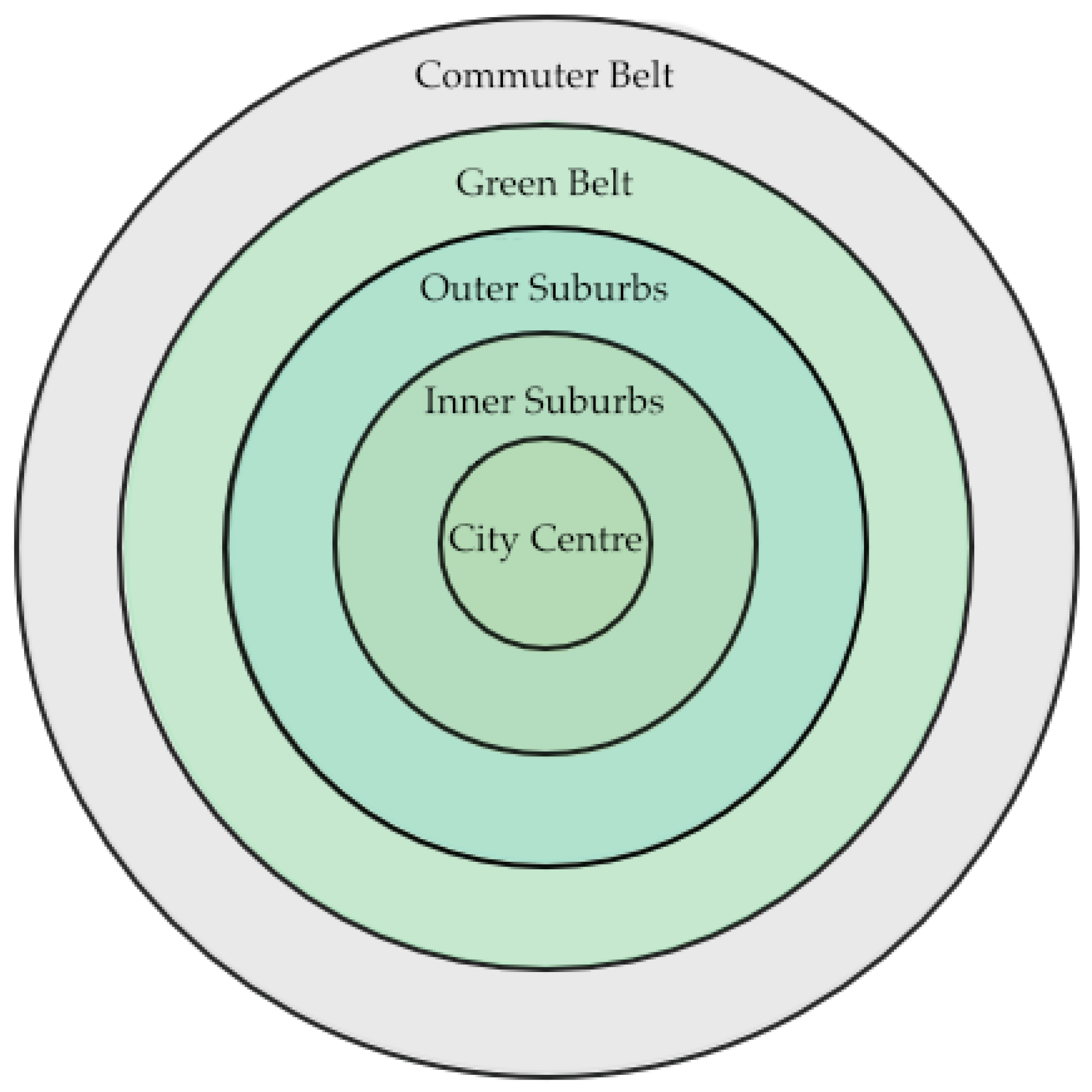
In this paper, we use a qualitative, interpretive research design, guided by secondary research and critical synthesis, in response to the exploratory nature of the research objectives, namely, to develop a strategic framework (the Green Blueprint) that can support the integration of UGI within the spatial logic of British cities. To clarify what we mean by ‘spatial logic of British cities,’
Figure 1 presents a simplified, concentric-zone diagram (City Centre → Inner Suburbs → Outer Suburbs → Green Belt → Commuter Belt). This pattern underpins most historic and contemporary UK urban plans and explains why, for example, green-infrastructure corridors tend to follow radial river valleys or former railway lines. Our subsequent case-study examples (London, Manchester, Sheffield) all sit within this broad spatial framework, which we revisit when discussing Green Belt interventions and peri-urban ecological networks.
This study refers to the spatial organisation of land uses, infrastructure, ecological networks, and socio-economic functions that shape urban form and connectivity. This includes considerations of how green spaces are distributed, accessed, and functionally linked across urban systems, as illustrated later through conceptual planning schemes; the investigation is templated on Saunders, et al.’ [
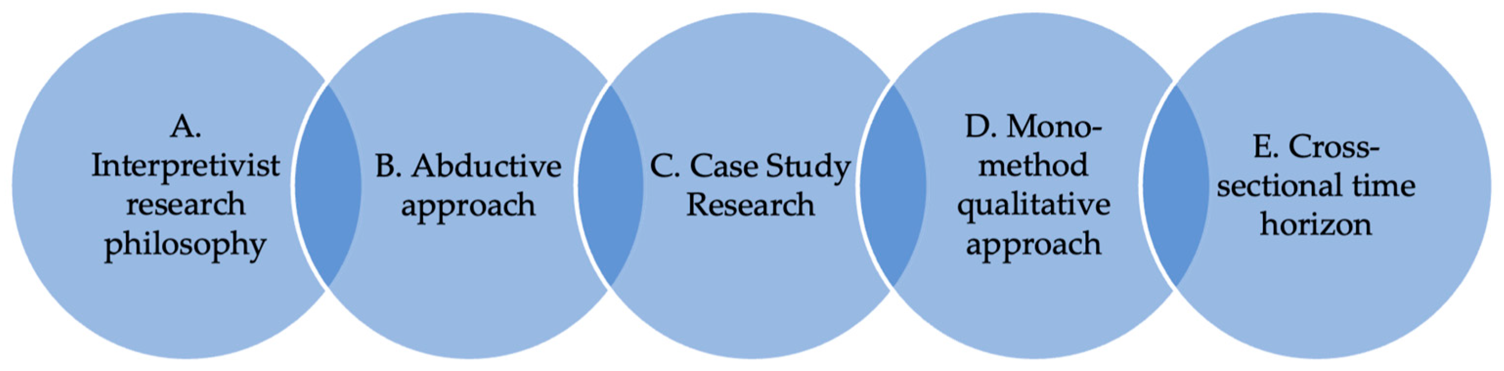
51] layered model of research design, namely, the “Research Onion”. Every level of the model affects methodological choices, and these are as follows (
Figure 2).
This study is framed in the interpretivist paradigm which acknowledges the multiplicity of social phenomena and the importance of subjective meaning to understand urban planning and environmental governance. Interpretivism is particularly appropriate for UGI research in that it is amenable to the exploration of place-based ecological, political and socio-cultural factors affecting urban resilience [
52]. This approach recognises that urban systems are social constructions and that it is in becoming, not the being that we must allow for some flexibility in our analysis rather than be fixated on generalisation.
An abductive method is used, which allows for moving back and forth between theoretical and empirical data. Abduction is well suited to conceptual work in that it enables researchers to draw new meanings from patterns that are recognised as well as from synthesised cases studies. This study responds to this challenge by merging well-established theoretical concepts, such as ecosystem services, resilience theory, and urban green infrastructure (UGI), with new frameworks like the Green Blueprint, using empirical demonstration and thematic cross-case comparison to illustrate their integration in practice.
This research is underpinned by a mono-method qualitative approach that can be used by secondary researchers with reference to the aims of theory building. This study is entirely dependent on qualitative sources of evidence such as peer-reviewed academic literature, planning reports/policy papers, and government agendas specifically pertaining to UGI and ecosystem services in the UK.
The method used is that of documentary analysis, a feature of secondary research designs [
53]. This is a method for the systematic collection, analysis, and synthesis of current sources to identify patterns, critically appraise case examples, and develop theoretical insights. The main databases used are SCOPUS, Web of Science, and Google Scholar, alongside grey literature from governmental and NGO organisations (e.g., DEFRA and The Wildlife Trusts) and planning authorities (such as in London, Manchester, and Sheffield).
This study is conducted within a cross-sectional time horizon, based on a literature and policy analysis of developments over the last 15–20 years, with a particular focus on events since the critical period of 2007 onwards when UGI was thrust onto the policy agenda in the UK. Although we allude to historical facts where necessary, we will focus on contemporary readings of the city and discussion of models for future-oriented urban planning.
Secondary data was selected based on the inclusion criteria including relevance to UK cities and UGI/ecosystem services and credibility of the publication. In the analysis, a thematic synthesis was applied that constitutes the merging of content analysis and grounded coding [
54]. Specifically, the content analysis involved identifying recurrent phrases and constructs such as ‘ecosystem services’, ‘climate resilience’, ‘biodiversity corridors’, and ‘community co-design’, while grounded coding was used to iteratively generate categories and themes, including governance innovation, multifunctionality, and spatial equity based on patterns emerging across the textual data. Case-study evidence from London, Manchester and Sheffield was compared to learn of any transferable principles and best practices.
4. Case Studies: UGI Implementation in Practice
This section presents the main findings of our investigation, focusing on how urban green infrastructure (UGI) is taking shape in practice across three UK cities: London, Manchester, and Sheffield. While formally titled “Case Studies”, this part of the paper effectively serves as the results section, capturing patterns, insights, and emerging trends from policy documents, and planning strategies. Although UGI has gained visibility in UK planning discourse, its implementation remains uneven, with each city responding differently based on local priorities, institutional arrangements, and community dynamics. To reflect this diversity, we structure the section around six interrelated themes. We begin by situating each city within its broader urban and ecological context, laying out why these cases were selected. We then explore how multifunctionality and ecosystem services are being addressed, in terms of environmental performance and in relation to public health, social equity, and climate resilience. Governance and policy integration follow as another key theme, with attention paid to how different levels of authority, planning cultures, and funding mechanisms are enabling, or in some cases obstructing, UGI development. We also examine the role of community participation, especially how citizens are involved in shaping green space and how this affects spatial justice and neighbourhood quality. The section then looks at innovation in nature-based design, showcasing examples where cities are testing new approaches to integrate UGI more effectively within the fabric of everyday urban living. Finally, we reflect on the recurring challenges, compromises, and lessons that emerge when translating UGI theory into practice. These themes provide perspectives on what it means to make cities greener, fairer, and more resilient in the face of complex environmental and social change.
4.1. Study Area
This study focuses on three major urban centres in the United Kingdom: London, Manchester, and Sheffield (
Table 1,
Figure 3). These cities were selected for their diverse geographic, demographic, and institutional contexts and because they represent different stages and strategies of urban green infrastructure (UGI) implementation. Each city provides a unique testing ground for the Green Blueprint framework and reflects the complex relationship between ecological assets and urban development.
London, as a global capital with high population density and substantial policy innovation in green infrastructure (e.g., the All London Green Grid), offers a mature example of integrated strategic planning. In contrast, Manchester, a post-industrial city with significant urban regeneration initiatives, presents a case where UGI is used to address socio-economic inequalities and climate resilience. Sheffield, often described as the UK’s “greenest city”, has a distinct topography and ecological richness. It provides a compelling context for nature-based solutions at the interface of urban and peri-urban land uses, particularly given its proximity to the Peak District National Park.
Table 1 summarises the key characteristics of each city, and
Figure 3 and
Figure 4 illustrate their location, urban footprint, and green-infrastructure systems using OpenStreetMap-derived data.
London, the largest and most complex of the three, exemplifies polycentric urbanism under tight formal planning control. Its built-up area is almost surrounded by an expansive, legally enforced Green Belt (
Figure 3). In that panel, the grey circle denotes London’s concentrated building footprints, while the dark-green hatched ring represents the statutory Green Belt just beyond the urban edge.
Manchester, by contrast, demonstrates a more dispersed, post-industrial urban fabric (
Figure 3). The grey blob illustrates the contiguous built-up core, but numerous small green patches (allotments, parks, fragmented open-space parcels) lie within and just beyond the suburban fringe rather than forming a continuous ring. This fragmentation reflects historical 19th- and 20th-century sprawl, deindustrialisation, and piecemeal redevelopment.
Sheffield occupies a distinct valley-driven footprint that stretches along the Don Valley corridor (
Figure 3). The elongated grey ellipse follows that valley, while the dark-green hatched ring of Green Belt often entails higher-elevation terrain resulting in an irregular, ovoid pattern rather than a neat circle. The Don Valley shape also drives river-corridor connectivity in ways that differ from London and Manchester.
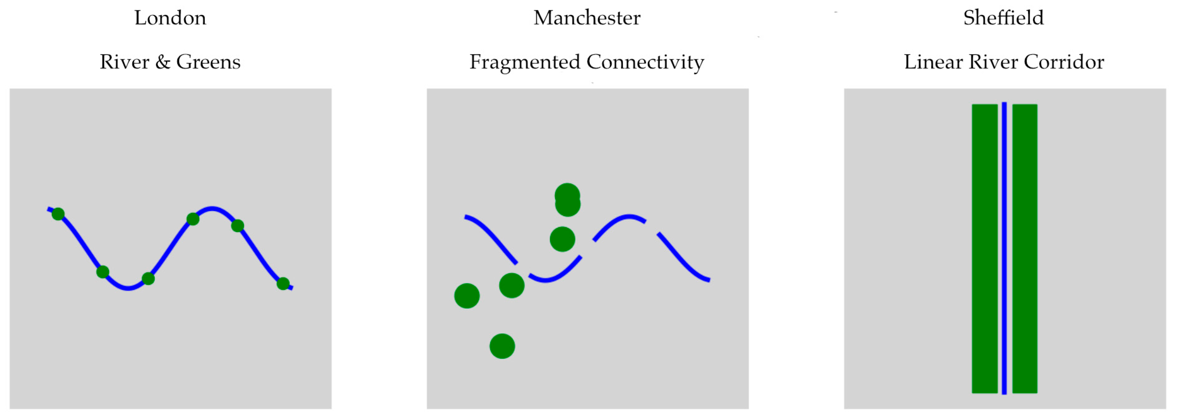
All three cities exhibit very different patterns of green-infrastructure connectivity, particularly along their main rivers. In London (
Figure 4), the Thames goes through a dense grey background, with green dots marking major parks and riverside open spaces. The nearly continuous Thames corridor provides a linear backbone linking inner-city green spaces to larger peri-urban parks. By contrast, Manchester (
Figure 4) displays the River Irwell and its tributary network as a series of broken blue segments. Scattered green circles highlight isolated suburban parks and allotments, illustrating why Manchester’s green infrastructure often requires deliberate “stitching together” (e.g., the Bee Network) to achieve true ecological continuity. Finally, Sheffield’s green-infrastructure network is dominated by a strong north–south “spine” along the River Don (
Figure 4). There, a straight vertical blue line represents the river corridor, flanked on either side by continuous green bands (floodplain meadows, riparian woodlands, linear parks). This robust, valley-driven connectivity extends uninterrupted from the urban core into the Peak District foothills, unlike the fragmented patterns seen in London or Manchester.
Table 1 and
Figure 3 and
Figure 4 provide a concise yet comprehensive overview of each city’s population and governance context (
Table 1), built-up footprint and Green Belt relationship (
Figure 4), and green-infrastructure connectivity along river corridors (
Figure 4). This “Study Area” framework establishes the spatial and policy backdrop for our subsequent analysis of how spatial logic, green belts, and river-corridor retrofits intersect across three diverse English cities.
By comparing these cities, this study reveals both transferable principles and site-specific challenges related to UGI integration. The selection was also informed by data availability, the presence of local green-infrastructure initiatives, and relevance to broader policy trends in the UK.
4.2. Multifunctionality and Ecosystem Services
Multifunctionality is a key principle for UGI, as this approach offers opportunities to address more than one urban challenge. Cities across the UK have started to do so by “operationalising” the concept, that is, by making the delivery of ecosystem services part of the spatial logic that structures the design of new green space. Multifunctional UGI is on a metropolitan scale in the All London Green Grid (ALGG) in London [
55]. The ALGG is conceived as a coordinated spatial structure that integrates ecological networks, recreational uses, and climate adaptation functions into an integrated network system [
50]. For example, plans along the Thames Estuary Path create habitat connectivity and provide flooding defence and cultural benefits, demonstrating co-delivery of regulating, supporting, and cultural ecosystem services [
56]. Manchester is already taking a local-level approach and trying to link UGI interventions with climate mitigation and health [
57]. The Irk Valley Project and green-infrastructure retrofits in post-industrial landscapes demonstrate how multifunctionality can be realised through place-based interventions that integrate carbon sequestration with active mobility corridors and community co-benefits [
7,
58]. These programmes combine green-blue corridors with socio-economic regeneration plans, demonstrating the contribution of UGI to ecological and human systems. In Sheffield, multifunctionality is integrated within the city’s Green and Blue Infrastructure (GBI) Strategy, which allows tolerating urban flooding and promoting biodiversity and attractive landscapes [
59]. For instance, the Porter Brook Pocket Park shows how daylighting a river and restoring wetland enable better stormwater management, urban cooling, and habitat for local species [
60]. This embodies a process of ecosystem services focussed design where built form and ecological function are coproduced.
These cases highlight that there is a commitment to mainstreaming multifunctionality as a core requirement for UGI planning and assessing UGI. Nevertheless, disparities still exist in terms of scale, governance context, and language of design. Whereas London shows strategic-level networking, Sheffield and Manchester emphasise a more localised approach to site-specific initiatives. The UGI strategies in these cities suggest that multifunctionality have the potential to work as a planning principle and performance measure in the realisation of resilient urban environments.
4.3. Governance and Policy Integration
Successful delivery of Urban Green Infrastructure (UGI) relies on innovative design and resourcing and flexibility of governance frameworks. In the UK, the mainstreaming of UGI has been more commonly through multi-scalar governance arrangements, cross-sectoral partnerships, and integrative policy tools that more accurately encapsulate the complexity of urban ecosystems and the services they provide. In London, the leadership of UGI governance has been influenced by the strategic direction of the Greater London Authority (GLA), most specifically the London Environment Strategy [
61] and the All London Green Grid (ALGG) [
55]. The ALGG facilitates policy coherence by connecting environmental planning to transport, housing, and health agendas in all 33 boroughs. Its governance is an embodiment of vertical integration, integrating city-wide strategies with local delivery plans. In addition, the “Opportunity Areas” (OAs) process enables targeted investment in green infrastructure, frequently through public–private development partnerships.
Manchester exemplifies a different mode of governance based on horizontal collaboration and knowledge production. The Manchester Green Infrastructure Strategy [
62] was developed through collaboration between the council, local universities, environmental NGOs, and regional bodies, including the Greater Manchester Combined Authority. Governance innovation in Manchester is typically structured around pilots, e.g., those of the EU-funded Green Surge and Ignition programmes, providing spaces for trialling new approaches to financing, measurement, or citizen engagement [
63]. These have helped to break down silos between departments dealing with the environment, economy, and health and to increasingly integrate UGI into broad resilience planning. Less strategically networked than London and less experimentation-driven than Manchester, Sheffield provides valuable entry points for work on adaptive governance. The Green and Blue Infrastructure Strategy [
64] was produced in the wake of severe flooding in the 2000s, situating UGI as a vital tool within the city’s flood resilience planning. Sheffield’s process of governing is based on the relationship between City Council, Environmental Agency, and third-sector campaigns, including the Sheffield & Rotherham Wildlife Trust. Such a partnership-based framework allows ecological objectives to be mainstreamed into development control, planning gain, and site-level initiatives, especially in post-industrial areas where regeneration is associated with the development of green corridors. Even with such institutional advancement, they are issues. Fragmentation between different levels of administration, disparities in funding, and the non-binding character of measures often constrain the systemic integration of UGI. In addition, it even promises other smaller cities like Sheffield that their fate will be decided largely on a project-by-project basis and ad hoc alliances rather than with concentrated planning powers of the sort London possesses. Reducing such an asymmetry will be crucial for scaling this Green Blueprint for the nation as proposed in this paper.
4.4. Community Participation and Spatial Equity
Urban Green Infrastructure (UGI) plays a vital role in promoting issues of social inclusion, public health, and sense of place. It provides benefits that are maximised when communities are actively engaged in the design and delivery processes. Spreading benefits while enhancing green infrastructure is a priority for many towns and cities; delivering equitable spatial distribution of these benefits is an ongoing struggle, one often restrained by historical deprivation, housing density, and planning priorities. In London, equity and access form one of a number of key themes in the recent London Environment Strategy [
65], with a specific policy to strive to have all Londoners living within a 400 m walk from green space. Programmes like Greener City Fund and Pocket Parks Plus are delivered to help communities green their local areas, frequently in coproduction with borough councils and civil society. Nevertheless, spatial data reveals that poor boroughs, especially in outer London, remain under-covered after the boost invested to address green equity [
16]. Furthermore, there has been discussion of the experience of “green gentrification”, particularly where flagship greening programmes intersect with real estate-led regeneration [
66]. In Manchester, the focus on community-driven regeneration is a key aspect of UGI strategies. Initiatives such as GrowGreen and My Wild City make clear connections between the creation of green space and social justice by targeting deprived communities [
67]. These ventures engage residents in planning, as well as incorporate environmental education and training. Manchester’s model reflects the importance of environmental justice, since it acknowledges that exposure to climate risk (e.g., from heat, flooding) tends to be greater for the poor and for diverse communities [
68]. Yet, long-term funding and institutional support for participatory mechanisms is tenuous.
There is a distinctive angle in Sheffield where bottom-up activism has been historically influential in maintaining green space policy. Sheffield’s urban–rural interface and its strong civic environmental history (e.g., Sheffield Environment Movement) have developed community-driven campaigns to protect and promote local green assets. The Sheffield Green and Blue Infrastructure Strategy proposes greater access to nature for all, yet recent debates surrounding tree felling show conflicts between local governance, expert knowledge, and community-based environmental custodianship [
69]. In all three urban areas, community engagement needs to be part of a forming a resilient and responsive urban structure. Nevertheless, there are profound variations in both the quality of UGI access and the level of community influence over green planning decisions. Both targeted spatial analyses (e.g., GIS and equity audits) and continuing citizen participation in marginal and rapidly changing neighbourhoods will be essential components of a more equity-centric agenda of UGI.
4.5. Innovation and Nature-Based Design Strategies
Nature-based solutions (NbS) are being considered as critical to how Urban Green Infrastructure (UGI) is both conceived and realised, providing scalable, cost-effective, and ecologically sensitive solutions that respond to urban issues. NbS have been explored to different extents in UK cities and have been embedded in policies and the built environment for innovative design [
70,
71]. This subsection examines how London, Manchester, and Sheffield are making use of design-led approaches to bring together multi-scalar landscapes, re-naturalised systems, and bio-inclusive infrastructures.
London has become a proving ground for large multifunctional NbS projects that combine ecological performance with architectural presence. Examples such as the Queen Elizabeth Olympic Park and the regeneration of Thamesmead both clearly illustrate a mixed approach crossing green-blue corridors, sustainable urban drainage systems (SuDS), and habitat mosaics within a high-density urban setting. The London Plan 2021 includes the Urban Greening Factor policy which establishes minimum greening requirement levels on new development, shifting the market towards bio-inclusive design [
72]. This regulatory experiment mirrors a changing dialogue, which has moved from regarding landscape as the leftover space to a central layer of infrastructure. In Manchester, however, this is very much part of the climate adaptation and post-industrial landscape regeneration agenda, both physically and politically. Examples taken from the Northern Gateway and Irk Valley corridors show how brownfield land can be regenerated into ecologically functional public assets by soil reclamation and clean-up, river restoration, and greenway creation. These typologies often have the blue infrastructure deeply integrated as central spines; the design of water-sensitive landscapes works as flood management and as a catalyser of biodiversity networks. The Ignition Project in Salford, for example, has established demonstrator sites which feature green roofs, rain gardens, and living walls in place to support climate resilience and drive green investment through new finance models. Sheffield, widely known as the UK’s “Outdoor City”, has embraced a place- and bioregional design logic. NbS in Sheffield are based on its topographical and hydrographic characteristics, using the urban river system of the Don as structuring elements of the renewal of neighbourhoods. This approach is illustrated by the Grey to Green programme, which has seen traffic-dominated corridors replaced with linear parks which incorporate SuDS, pollinator planting, and permeable paving. Importantly, the design guidelines here emphasise image legibility and local distinctiveness, which enhance ecological identity and placemaking.
In all three, innovation in UGI design is pushed by a confluence of ecological science, urban aesthetics, and policy experimentation. London is ahead in terms of innovation and profile regarding regulation; Manchester shows technical integration with climate change impacts; and Sheffield promotes landscape character and civic identity. These cases demonstrate the flexible and site-specific nature of nature-based urbanism and the mediating role that design plays in relation to the integrity of ecosystems versus everyday urban experience.
4.6. Barriers, Trade-Offs, and Lessons Learned
Urban Green Infrastructure (UGI) is increasingly recognised in UK cities for its multifunctional benefits. However, its inclusive and systemic implementation remains uneven due to persistent barriers and trade-offs. This subsection explores these challenges through a comparative lens, based on the analysis of London, Manchester, and Sheffield. Each city presents a different governance model and policy architecture, yet they all struggle with similar institutional and financial hurdles.
Table 2 shows the key dimensions of UGI strategy, governance, and community engagement, and explicitly connects these with observed barriers, enabling conditions, and lessons learned. This typology illustrates both the diversity of implementation models and the common structural constraints that hinder scaling.
For instance, institutional fragmentation remains a cross-cutting issue. London’s borough-level autonomy creates patchy delivery despite strategic oversight by the Greater London Authority. In Manchester, short project cycles limit continuity, even with its partnership-driven governance. Sheffield faces limitations in technical and fiscal capacity that constrain the scaling of successful pilots. Funding volatility, governance silos, and competing land-use priorities further complicate UGI mainstreaming.
Trade-offs between ecological performance and urban functionality, such as balancing flood resilience with high-use public space, require sensitive, site-specific design. Additionally, concerns over green gentrification underline the social risks of poorly integrated UGI.
Despite these challenges, innovative mechanisms like London’s Urban Greening Factor and Manchester’s private-sector-engaged Ignition Project offer promising routes for more systemic implementation. A refined Green Blueprint must respond to these insights, creating adaptive pathways that are context-specific yet scalable across varied urban typologies.
5. A Green Blueprint for Future Cities in the UK
5.1. Conceptual Overview
As UK cities face mounting challenges from climate volatility, biodiversity loss, and socio-spatial inequality manifested in uneven access to green space, environmental risk exposure, and health disparities, there is an urgent need to operationalise a coherent, scalable, and context-sensitive framework for Urban Green Infrastructure (UGI). The Green Blueprint addresses these inequities by drawing together insights from spatial planning theory, ecosystem services, participatory governance, and nature-based urbanism.
The Green Blueprint conceptualises a multi-layered approach to mainstreaming UGI. It is premised on the recognition that UGI must be treated not as an ancillary design feature but as a critical infrastructural system with co-benefits across environmental, social, and economic domains. The framework is structured into five integrated domains: (1) Spatial Planning; (2) Governance and Policy; (3) Community Engagement; (4) Design and Innovation; and (5) Monitoring and Evaluation, each addressing distinct yet interdependent levers for systemic transformation. As shown in
Table 3, these domains outline strategic objectives, key actions, and the lead stakeholders responsible for implementation. The framework emphasises vertical alignment (national to local) and horizontal integration (across policy silos) to overcome institutional fragmentation and optimise resource mobilisation.
5.2. Spatial Planning Integration
Strategic planning remains the most potent aspect for embedding UGI within the urban form. The Green Blueprint advocates for the codification of UGI through instruments such as Urban Greening Factors (UGFs), spatial zoning for ecosystem services, and urban ecological networks. Drawing from the London Plan’s UGF and the ALGG, the framework calls for mandatory green space performance standards within all new developments, adapted to local biophysical and demographic conditions. Integration into Local Plans and National Planning Policy Framework (NPPF) updates is essential to mainstream ecological design principles at scale.
5.3. Governance and Policy Alignment
Effective governance of UGI requires institutional innovation beyond environmental departments. The Blueprint proposes the establishment of UGI Coordination Units within city administrations to ensure coherent delivery across health, housing, and transport portfolios. National guidance from bodies such as Defra and the Environment Agency should enable regional adaptation, with cross-sectoral taskforces developing city-specific UGI Action Plans. Inter-municipal knowledge exchange platforms (e.g., through Core Cities or UK100) should be formalised to accelerate policy learning and technical standardisation.
5.4. Community Engagement and Equity
To realise the full socio-ecological potential of UGI, community participation must be structurally embedded throughout the planning and implementation cycle. The Green Blueprint calls for participatory design methodologies, such as green charrettes, citizen juries, and equity audits [
85]. Municipal funding streams should be directed to support local stewardship models and community-led greening projects, especially in under-served neighbourhoods. Publicly available spatial tools (e.g., Green Space Access Maps) can improve transparency and empower citizens to advocate for improved access and quality.
5.5. Nature-Based Design and Innovation
The success of the Green Blueprint also depends on embedding innovation in both ecological and urban design. This entails incentivising multifunctional landscapes that serve as stormwater infrastructure, biodiversity habitat, thermal buffers, and community spaces. The use of design standards (e.g., CIRIA SuDS Manual), performance modelling (e.g., i-Tree Eco), and demonstration projects (e.g., Salford’s Ignition Living Lab) can help diffuse best practices. Policies must ensure that ecological integrity is not compromised by aesthetic or real estate imperatives, particularly in dense urban areas.
5.6. Monitoring, Evaluation, and Adaptive Learning
Lastly, the Blueprint emphasises the importance of robust evaluation mechanisms. Standardised indicators, such as percentage green cover, ecosystem service provision, and equitable access metrics must be developed and adopted across jurisdictions. The framework supports the creation of a National Urban Green Observatory, potentially housed within the Office for National Statistics (ONS), to track progress and inform adaptive governance. Longitudinal research partnerships with academic institutions can further ensure that policy evolves in response to emerging evidence and local feedback.
5.7. Operational Guidelines and Examples for Implementing the Green Blueprint
To translate the Green Blueprint into practice, cities should begin by integrating UGI directly into spatial planning. For example, local councils can amend Development Plans to include a dedicated UGI chapter, requiring all major proposals, such as residential developments over ten units or commercial projects exceeding 1000 m2, to submit a “Green Infrastructure Statement” that demonstrates net gains in green corridors, permeable surfaces, and tree canopy cover. In Manchester, such an approach could mandate that each District Spatial Strategy site incorporates a publicly accessible green corridor, effectively embedding multifunctional green space from the planning stage. At the same time, governance frameworks must adapt to support UGI coordination. Establishing a cross-departmental UGI Coordination Unit within the city council comprising representatives from Planning, Environmental Protection, Public Health, and Transport ensures that monthly meetings review upcoming applications, align budgets, and monitor progress against UGI targets. For instance, Sheffield could formalise a “City-Wide UGI Taskforce” tasked with producing an annual implementation report tracking new green roofs, street tree plantings, and blue-green corridor completions, while fostering inter-agency memoranda to co-finance SuDS projects between Highways and Parks teams.
Community engagement must be embedded early and continuously: councils might develop a standardised “UGI Co-Design Toolkit” for councils to facilitate two to three charrettes per year. These workshops would combine mapping exercises, identifying “green deserts” with “Design Your Street” sessions and micro-grant programmes, deliberately directing at least thirty percent of funding to wards in the lowest two deciles of the Index of Multiple Deprivation. London’s boroughs, for example, could adopt and expand the “Pocket Parks Plus” scheme so that any street tree or micro-park initiative requires a virtual interactive map for resident nominations, a half-day workshop to finalise planting species, and formation of a Community Steering Committee that receives a small maintenance fund to organise quarterly “Tree Care Days”.
Design and innovation guidelines should be captured in a citywide “Green Infrastructure Design Guide” that sets minimum performance standards: for instance, requiring that at least half of all new development rooftops larger than 1000 m2 be planted with extensive green roofs containing a minimum of 80 mm of substrate. The guide can include a “UGI Palette” listing approved technologies such as modular green walls, bioretention planters, native pollinator plants with technical specifications for soil mix and infiltration rates. Developers bidding for Manchester’s Large-Scale Regeneration Zones could be required to submit a “UGI Innovation Plan” demonstrating, for instance, a 20 percent reduction in peak runoff by integrating infiltration trenches beneath parking areas, blue-green roof systems linked to rainwater harvesting, and pocket parks at regular intervals.
Finally, robust monitoring and evaluation mechanisms are crucial. Local research and innovation units should host a “UGI Metrics Dashboard” with indicators such as hectares of new tree canopy, tonnes of carbon sequestered, percentage reduction in combined sewer overflow events, and the number of residents living within 300 m of green space. Data collection protocols might specify LiDAR canopy surveys every two years and water quality sampling before and after SuDS installations. In Sheffield, a partnership with the University of Sheffield could create “Living Labs” in three neighbourhoods, where sensors in rain gardens and green roofs feed real-time data to an open portal. Students and council officers could then analyse performance biannually, adjusting planting palettes or soil depths based on observed outcomes. Using these operational steps and real-world examples, planners can move from abstract principles to tangible green infrastructure on the ground, ensuring that the Green Blueprint becomes a living, adaptable framework for building resilient, inclusive urban futures.
6. Discussion
The conceptualisation of Urban Green Infrastructure (UGI) as the central framework of new city design in the UK marks a significant shift in the way that cities are planned, one that integrates systems reasoning with spatial justice and climate adaptation. This research explores a holistic view of UGI through the Green Blueprint framework, but several barriers and knowledge gaps remain. A dominant tension in the operationalisation of UGI is the gap between policy ambition and operational delivery. Despite the national orientation of policy statements like the NPPF and the Environment Act 2021 toward a “pro-nature” ethos, the means to translate these ambitions into spatially just and ecologically significant infrastructure are still piecemeal. Development viability and housing targets are prioritised within the planning systems, at the expense of multifunctional green space in high-rise and deprived areas. This raises a question of how space is organised, regardless of the urban land-use values, embedded in low-income housing decisions [
86]. The conversation is also a testament to the critical nature of inter/transdisciplinary synthesis. UGI integration is at the nexus of urban design, landscape ecology, environmental psychology, hydrology, public health, and economics. However, institutional and academic arrangements often work in silos of discipline. For instance, landscape architects may highlight aesthetics, engineers work on stormwater functions, and public health professionals ensure access and equity. Without such integrative knowledge systems, UGI will remain a piecemeal intervention that fails to realise its full multitasking potential [
87]. There is a great demand for spatially explicit data on the provision of ecosystem services, spatial equity, and community preference. UGI assessments generally focus on biophysical measures (e.g., temperature cooling, runoff capture) or economic valuation, with little consideration of cultural and social services that affect long-term public acceptance and care. Critically, citizen-led work on green infrastructure has been inadequately documented in the academic literature, despite its potential contribution to inclusive governance practices [
88,
89,
90].
This study also observes an unattended issue in long-term adaptive monitoring. Today, feedback loops for assessment and learning are a rare input to UGI projects, which hinders their responsiveness to dynamic socio-ecological processes such as urbanisation, demographic shift, or climate shocks. There is an increasing argument to incorporate living labs, citizen science, and nature-based indicators into planning to facilitate evidence-based adaptation. Another issue that has been under researched is the relation between UGI and urban inequality. Although UGI is frequently presented as an inherently positive intervention, it may serve to reinforce existing inequalities through green gentrification and displacement. It can be tackled through design of planning and funding processes that work to deliberately include distributive and procedural justice considerations and make space for marginalised voices in co-design processes. Although there is generally a wide recognition of nature-based solutions, the current planning cultures and governance modes are frequently risk-averse, control-oriented, and process-driven, heavily influenced by ongoing short-term economic logics and departmental silos. Dislodging this inertia will take transformative leadership, regulatory modernisation, and capacity building in all levels of government, in the private and third sectors. This paper aims at contributing to this new governance of change with its ambitions and risks by means of discussing how the Green Blueprint provides a particularly strong vision of UK cities of the future but one that is also contingent upon a new governance ethos: an ethos of inclusion, adaptability, and interdisciplinary, evidence-informed practice.
While this study provides a strategic conceptualisation of Urban Green Infrastructure (UGI) through the Green Blueprint framework, it is not without limitations. First, the analysis is based on secondary data and case studies from three UK cities, London, Manchester, and Sheffield, chosen for their relative maturity in UGI adoption. As such, the findings may not fully capture the diversity of challenges faced in smaller or less-resourced urban areas. Secondly, while the qualitative, interpretivist methodology enabled a rich synthesis of governance, spatial, and community factors, it lacks empirical validation through primary data such as stakeholder interviews, surveys, or performance metrics.
Future research should build on this foundation by engaging in participatory action research with local authorities, planners, and communities to co-develop and test the Green Blueprint in varied urban contexts. Additionally, the operationalisation of UGI monitoring frameworks, particularly longitudinal impact tracking, remains underdeveloped and warrants deeper exploration. Incorporating socio-economic data, environmental performance indicators, and citizen-reported outcomes will be essential to strengthen the evidence base for UGI’s contribution to urban resilience, equity, and ecological integrity. Expanding the framework to account for rural–urban interfaces, post-industrial regeneration zones, and climate justice considerations also offers promising avenues for advancing the application of green infrastructure in future planning systems.
7. Conclusions
This paper has critically explored UGI as a central strategy for improving urban resilience, equity, and sustainability in UK cities. Based on the literature review, case studies, and conceptual framing, we suggested the “Green Blueprint”, a model and scalable multifunctional approach. This model coincides with an ecological system thinking in conjunction with modern-day urban requirements.
The results highlight UGI’s potential for providing multiple ecosystem services, including heat amelioration, stormwater regulation, biodiversity support, social well-being, and economic co-benefits. Such services not only manage the material vulnerabilities of cities in the Anthropocene but also build towards a more equitable and inclusionary urban fabric. Yet these studies also uncover continued obstacles to implementation, from policy siloes and organisational inertia to social injustice and data deficits.
Various policy implications arise from the Green Blueprint framework. At the national level, there is a need for a comprehensive Urban Green Infrastructure (UGI) plan that outlines specific goals, establishes robust monitoring frameworks, and secures long-term funding mechanisms. Embedding ecosystem service accounting into local development plans is essential to ensure that the multiple benefits of UGI are systematically valued and integrated into urban planning decisions. Local governments should also institutionalise interdisciplinary planning teams that bring together expertise from environmental science, urban design, public health, and community development to ensure more holistic and coordinated implementation. Furthermore, upscaling community-driven and co-governed models of green infrastructure will be crucial to promote spatial equity and long-term stewardship. Realising these ambitions will require sustained investment in long-term monitoring systems, the creation of urban living labs, and the use of adaptive feedback mechanisms that allow policies and designs to evolve in response to emerging challenges and evidence. Moving forward, the Green Blueprint is a flexible framework designed to adapt to evolving local conditions, support innovation, and reflect community aspirations. It holds the potential to bridge disciplines, scales, and stakeholder groups, fostering urban environments that are both vibrant and inclusive.
If UK cities are to respond to the multiple challenges of climate change, biodiversity loss and social inequality, Urban Green Infrastructure must shift from the margins to the mainstream of planning discussion. This shift requires intellectual rigor and political will, institutional innovation, and collective imagination to create cities that are not just sustainable but thriving, equitable, and resilient by design.


