1. Introduction
During the 20th century, urbanization led to the creation of a new kind of city, known as compact cities [
1]. Compact cities and eco-cities are among the most promoted models of sustainable urban design and represent key approaches in sustainable urbanism [
2]. Compact cities are defined by extensive areas of buildings and paved surfaces, leaving limited space for greenery [
3].
This could pose a significant problem for city residents, as they would lose the valuable ecosystem services that trees and green spaces offer. As defined by the Millennium Ecosystem Assessment [
4,
5], ecosystem services are the multiple benefits provided by ecosystems to mankind, and the same document divides them into four categories [
6]:
Supply services, covering products obtainable from ecosystems;
Regulatory services, which are the benefits obtained by active processes in different ecosystems;
Cultural services, covering all non-material benefits obtained by ecosystems;
Life support services, which are the services necessary for the production of all other ecosystem services.
In the urban context, the benefits referring to supply services are not so many, while the benefits related to regulatory, cultural, and life support services have a predominant role. An example is the mitigation of the Urban Heat Island (UHI) effect by vegetation, which dissipates energy through evapotranspiration and acts as a thermal insulator for buildings when present on green roofs and facades [
7,
8,
9,
10]. Another significant benefit of urban greenery is its ability to mitigate air pollution through two primary mechanisms. First, it involves the storage of carbon within plant biomass [
11]. Second, vegetation, particularly trees, acts as a natural filter by capturing particulate matter from the air [
12]. Vegetation also plays a crucial role in improving rainwater management through a threefold process, particularly in the case of trees [
13]: rainwater is partially intercepted by the canopy, partially flows along the stems/trunks of various species, and partially infiltrates into the ground, avoiding the formation of intense runoff, which is significantly exacerbated in urban areas by impervious soil [
14]. In addition, the presence of green areas in urbanized environments makes it possible to satisfy important recreational and social needs by making cities more livable and raising the population’s awareness of environmental issues [
15]. In fact, although the available literature on this topic is still limited, recent studies indicate that exposure to green spaces significantly enhances individuals’ psychophysical well-being [
16]. This conclusion is supported by the evaluation of physiological indicators such as brain activity in the prefrontal cortex, heart rate, blood pressure, and levels of adrenaline and noradrenaline in urine, as well as various psychological indices [
17,
18,
19].
The planning and management of these natural areas in the city are becoming increasingly important, not only for the maintenance of the above-mentioned services, but also for the protection of biodiversity and for their active role in the establishment of ecological networks. As reported by [
20], ecological networks in urban and rural areas are crucial, as they provide the only means to establish ecological corridors, promote connectivity, and enable the movement of wildlife in these fragmented landscapes. In this regard, [
21] also argue that urbanization, in addition to being a threat to global biodiversity, can surprisingly also be crucial for the conservation of some species, especially through the management, conservation, and planning of urban green spaces.
The presence of vegetation in urban areas, while offering numerous benefits to residents, also brings certain drawbacks or ecosystem disservices (EDSs). EDSs are often grouped into categories that highlight their negative effects [
22]. These include health-related issues (e.g., disease spread and allergens), economic and financial costs (e.g., soil degradation and damage to infrastructure), safety and security challenges (e.g., storm damage, perceived crime, and wildlife conflicts), as well as esthetic impacts (e.g., obstructed views or undesirable flora). EDSs associated with trees may have the most significant impact [
23,
24] and include the production of pollen and other substances that can trigger allergies, such as exacerbating respiratory problems in sensitive subjects [
25], falling fruits and branches [
26], the conflict with urban infrastructure (e.g., trees can block traffic signs, streetlights, and views, reducing visibility and safety), the intrusion and outcropping of roots that can break sidewalks, roads, and building foundations, and the risk of uprooting and crashing, especially in high winds. The latter occurrences are often aggravated by various stresses, particularly abiotic factors, to which city trees are frequently exposed. These include soil compaction and paving over the root zone that reduces gas exchange and rainwater infiltration, planting in soils poor in organic matter, high temperatures, pollution, and incorrect management activities, especially pruning (
Figure 1). In this regard, appropriate tree pruning minimizes interference with structures, enhances wind tolerance, and decreases the likelihood of branch failures that could endanger people or property. Conversely, improper pruning techniques not only compromise a tree’s esthetic appeal, but also create extensive wounds that heal slowly [
27]. These wounds can become entry points for harmful pathogens, such as parasitic fungi. Some fungi, like
Fomes fomentarius, may undermine the tree’s structural integrity, while others, such as
Armillaria species, can diminish its overall vitality [
28].
The annual ISTAT (Italian Institute of Statistics) reports contain data on felled trees in Italy’s provincial capitals, offering valuable insights into local administrations’ concerns regarding the impact of the damage caused by falling branches or entire trees. In the latest published report referring to data from 2021, for example, it is reported that 27,960 trees were cut down in that year, with 21,580 (approximately 77% of the total) removed due to the risk of falling. Notably, in the province of Venice, all 403 trees removed (100%) were due to this risk. The 2023 Statistical Yearbook of the Italian Fire Brigade (
https://www.vigilfuoco.it/chi-siamo/le-statistiche/annuari-delle-statistiche-ufficiali-del-corpo-nazionale-dei-vigili-del-fuoco, accessed on 20 April 2025) reveals that securing unstable trees ranks fifth among the most frequent type of technical rescue operation. In particular, nationwide interventions required for dangerous trees show a steadily increasing trend over the ten-year period from 2014 to 2023, with the exception of the period 2020/2021. The number of interventions rose from about 3500 in 2014 to almost 68,000 in 2023, with an increase of more than 35% from 2022 to 2023. These statistics underscore the growing significance of tree-related hazards in urban environments, highlighting the urgent need for improved urban forestry management strategies and risk assessment protocols to ensure public safety while preserving the valuable ecosystem services provided by urban trees.
A study was conducted to identify and analyze the key factors influencing tree falls in urban environments, with the aim of improving urban forest management and public safety. The main objectives of the study were as follows:
To determine the relationship between meteorological conditions and tree fall incidents;
To analyze the spatial distribution patterns of fallen trees;
To identify tree-specific characteristics (e.g., species, location, and grouping) that influence fall susceptibility;
To develop recommendations for enhancing monitoring, maintenance, and preventive strategies for urban trees.
2. Materials and Methods
The metropolitan City of Venice, located in north-eastern Italy, was chosen as a case study (45°26′23″ N 12°19′55″ E). Venice’s unique history, artistic heritage, and urban landscape led to its designation as a UNESCO World Heritage Site. The City of Venice has approximately 260,000 inhabitants, unevenly distributed across an area of 415.9 km2 (including the lagoon area).
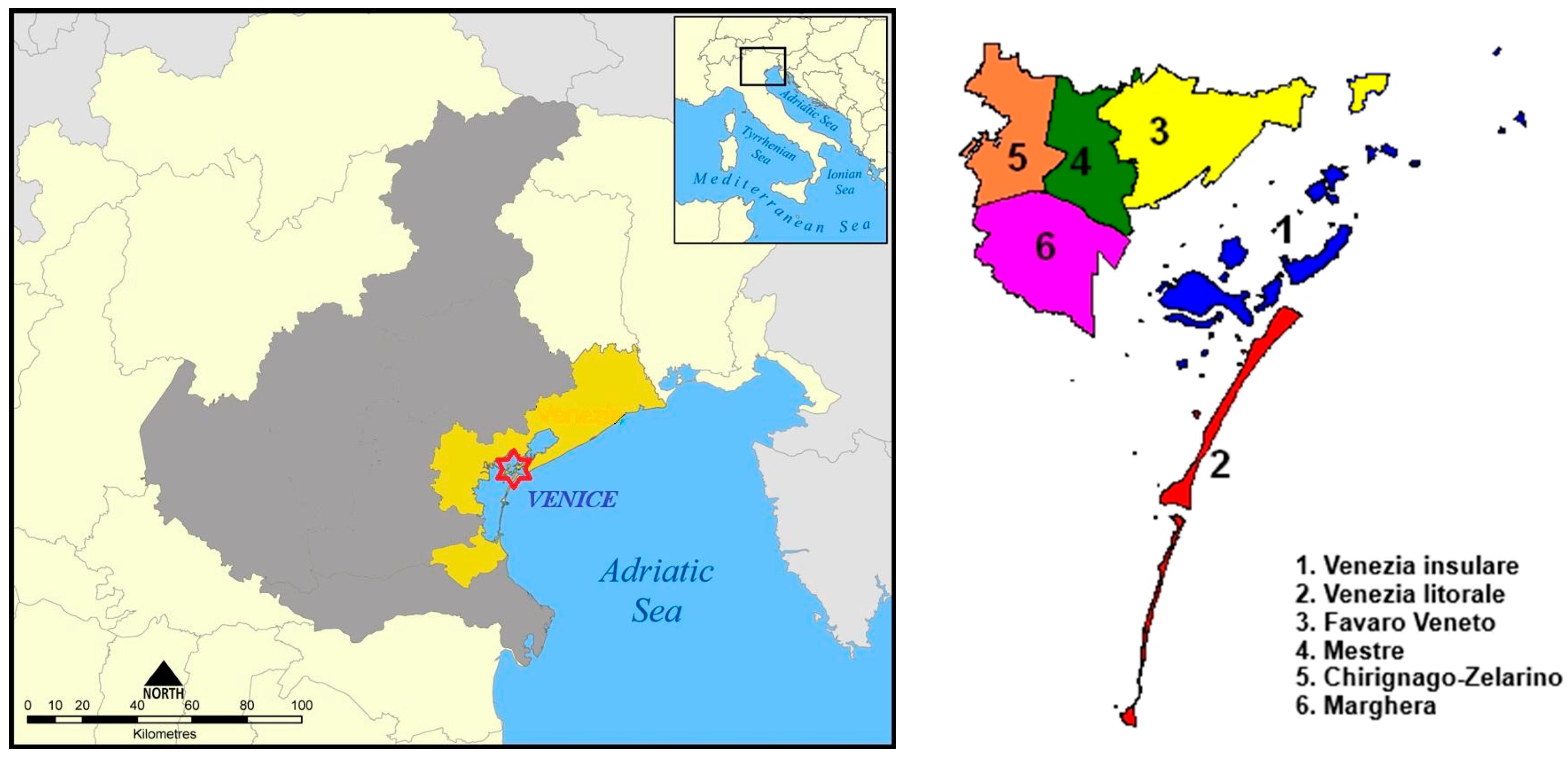
The City of Venice is divided into six municipalities, established to represent local communities, address their needs, and foster development across the metropolitan area. The six municipalities are as follows: 1. Venezia insulare, 2. Venezia litorale, 3. Favaro Veneto, 4. Mestre, 5, Chirignago-Zelarino, 6. Marghera (
Figure 2). This subdivision also plays a role in organizing the work required for the management of green areas. This territorial division was used for the various useful comparisons analyzing weather-related tree falls. Beyond the six municipalities, a separate category designated as ‘0′ has been established for school grounds, which are managed independently.
The study was conducted over a four-year period from 2019 to 2022. During this time, all tree falls resulting from extreme weather events were documented. For each event, relevant meteorological data along with the dendrometric and taxonomic information of the affected trees were collected. Data collection was conducted in partnership with Consorzio Zorzetto, a social consortium operating in various sectors, including public green space management. This consortium coordinates multiple cooperatives responsible for maintaining green areas across the City of Venice.
Weather data were obtained from the database available on the website of ARPAV (Agenzia Regionale per la Prevenzione e protezione Ambientale del Veneto), the regional agency for environmental protection and prevention in Veneto, which collects weather data from the network of stations distributed throughout the territory. Specifically, in the City of Venice, there are two weather stations, one located on the mainland and one in Venezia insulare. The daily data of the following meteorological parameters were collected: rainfall, air temperature, average wind speed and wind direction, and maximum gust speed. This comprehensive set of weather data allowed for a detailed analysis of the meteorological conditions associated with tree failures. The study examined 106 weather events in total. Data on fallen trees were obtained from the management software GreenSpaces version 5.2 (R3GIS, Bolzano, Italy), an integrated and geo-referenced platform used by Consorzio Zorzetto.
Over the four-year study period, 450 fallen trees were recorded and analyzed (
Figure 3). This dataset includes all trees that either broke or were completely uprooted during extreme weather events within the timeframe. It is worth noting that distinguishing between broken and uprooted trees would have been valuable information for our analysis. However, this distinction was not possible, as our assessments were conducted after the removal crews had already cleared the fallen trees. This limitation in data collection highlights an area for potential improvement in future studies. Additionally, trees that fell in private areas were unfortunately excluded from this study, as they could not be accounted for by the tree data collection survey.
For each tree in the dataset, the following information was collected based on the GreenSpaces database:
Tree I;
Zone number (from 0 to 6, derived from the internal subdivision of the territory);
Location code and location name;
Gender, species, and variety;
Growth site (e.g., permeable or impermeable pavement, grassed ground, or containers);
Physiological phase (as classified by Raimbault and Tanguy [
29]);
Date of felling;
Height class (m) and diameter at breast height DBH (cm);
Social position (e.g., in groups, isolated, or as street trees);
Coordinates.
Historical data on prior pruning practices, infrastructure conflicts (e.g., sidewalk damage and utility interference), and root zone conditions were unavailable, potentially obscuring relevant confounding factors that could influence tree health and stability assessments.
A significant portion of the data analysis focused on evaluating the distribution of tree failures across various factors. The primary factor considered was time, examining the distribution of failures over the four-year study period. This analysis helped identify the seasons and the months when tree failures were most prevalent.
Subsequently, the study examined the relationship between tree failures and weather conditions, particularly wind gust intensity and cumulative rainfall. For wind intensity, four classes were established (0–5, 5–10, 10–15, and >15 m/s). This subdivision was based on the Beaufort scale definitions of strong wind (above approximately 10 m/s) and very strong wind (above approximately 15 m/s). Weather events were categorized according to these intensity classes, and the number of fallen trees was recorded for each event.
To enable meaningful comparisons, the average number of fallen trees per event was calculated for each intensity class. This was carried out by dividing the total number of fallen trees in each class by the number of events in that class. This approach was crucial for accurately assessing the relationship between wind gust intensity and tree failure rates.
Weather events were categorized into six classes, each with a 5 °C temperature range, to assess the potential influence of temperature on tree failures. A similar approach was applied to cumulative rainfall, for which four classes were created (0–20, 20–40, 40–60, and >60 mm). It is important to note that these class divisions were established based on the authors’ professional judgment and field experience, as no previous studies addressing this specific categorization were found in the literature.
The distribution of tree failures was evaluated across municipalities to identify the most affected areas. This was carried out by calculating the number of failures per hectare, obtained by dividing the number of failures in each municipality by its surface area.
Species-specific vulnerability was analyzed by examining the distribution of failures among different tree species. To understand which areas of the City of Venice are most susceptible to tree failures, the distribution was assessed according to growth site and social position. This analysis aimed to identify the most suitable areas for planting specific tree species. An additional analysis evaluated the distribution of tree failures according to physiological stage, with the goal of defining the optimal structure for urban tree populations. These analyses collectively provide insights into the spatial, species-specific, and age-related patterns of tree failures, informing future urban forestry management strategies.
The next step involved analyzing the spatial autocorrelation among fallen trees. This analysis required both geographical data and a spatial weights matrix, which was constructed using the X and Y coordinates extracted from the database of fallen trees. The analysis was conducted using R version 4.1.2 [
30], incorporating the date of tree failure as the variable of interest in conjunction with the created matrix.
This spatial autocorrelation analysis aimed to identify any significant patterns or clusters in the distribution of tree failures across the study area, potentially revealing localized risk factors or environmental conditions contributing to tree instability. The matrix of spatial weights was produced using the
knearneigh() function of the “spdep” package [
31]. In addition, the
knn2nb() function was used to perform Moran’s I test. The spatial autocorrelation analysis was performed with the function
moran.test() considering the date of the event.
3. Results
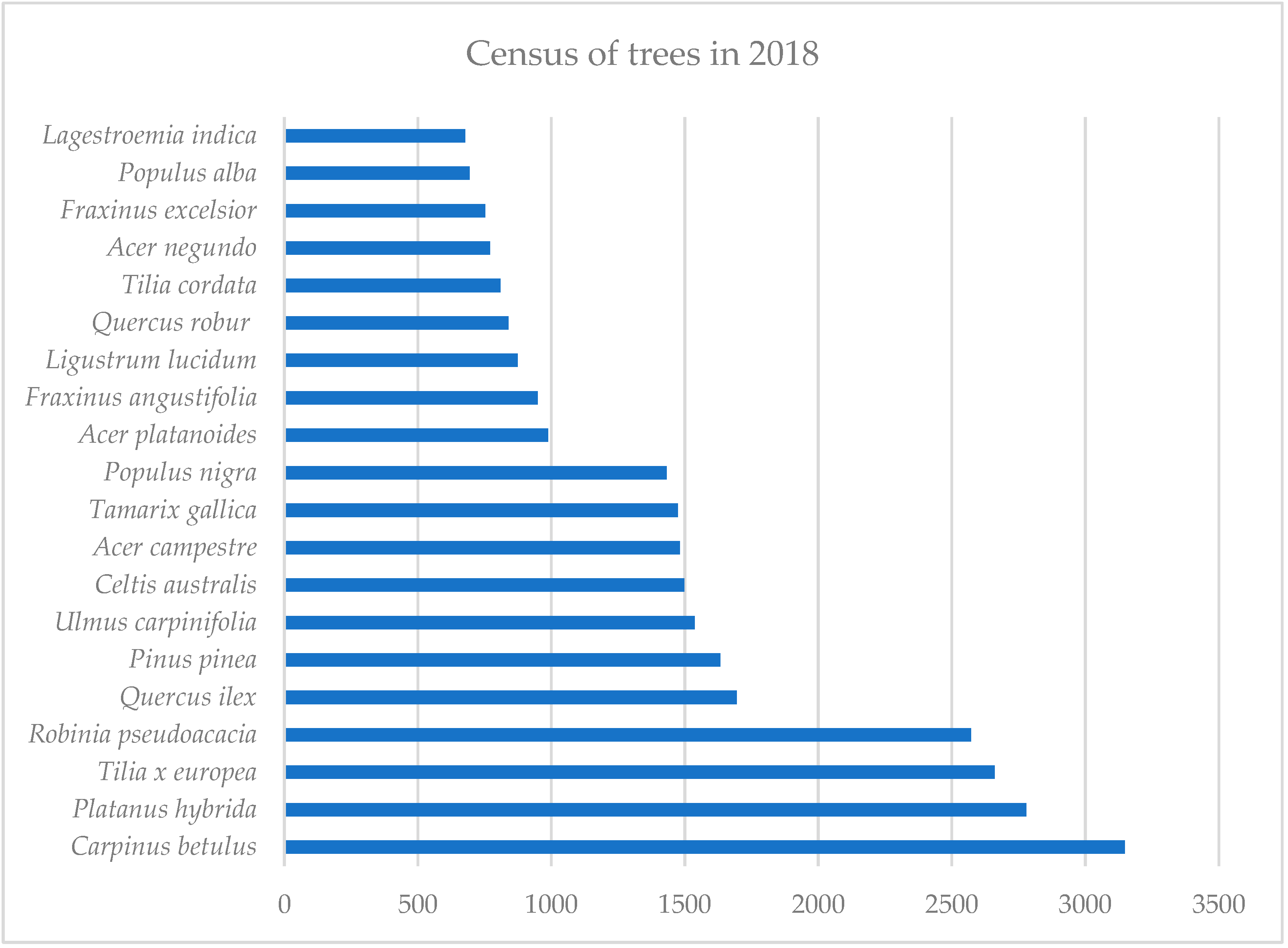
Figure 4 illustrates the 20 most prevalent tree species, out of a total of 74 species identified in the urban forest inventory, observed in 2018. This year serves as the baseline year for assessing fallen trees over the four-year study period. These species are characteristic of urban environments in the Po Valley and along the Italian coast, including notable examples such as
Pinus pinea L. (stone pine) and
Tamarix gallica L. (French tamarisk). This composition reflects the typical urban forest structure in Northern Italian cities, which often combines native species with non-native trees selected for their adaptability to urban conditions [
32].
The evaluation of the distribution of tree failures during the four years under review provides the results visible in
Figure 5. As we can observe, the majority of the falls occurred during the summer months, particularly July and August, with the only exception of an abnormal extreme weather event occurring in November 2019. The most significant event occurred on the night between 16 and 17 August 2021, when 83 trees were felled. Although the precipitation in those days was relatively low (34 mm), high wind gusts were recorded with a peak of 26.8 m/s, a value close to that of a Category 12 hurricane on the Beaufort Wind Scale (speed of 32.5 m/s). The event on the night of 12 November 2019 occurred during a period of intense precipitation (more than 150 mm in a few days), but also with a maximum gust of 22.9 m/s, which was also the peak value for the year.
The year 2020 stands out as an anomaly due to the surprisingly low number of tree falls during the summer months, despite experiencing some of the most extreme weather conditions recorded throughout the study period. While we cannot be certain, this peculiarity might be attributed to the partial lockdown in effect at the time. It is possible that tree removal operations were conducted as “extraordinary” measures, potentially bypassing standard reporting procedures and thus not being reflected in routine data collection.
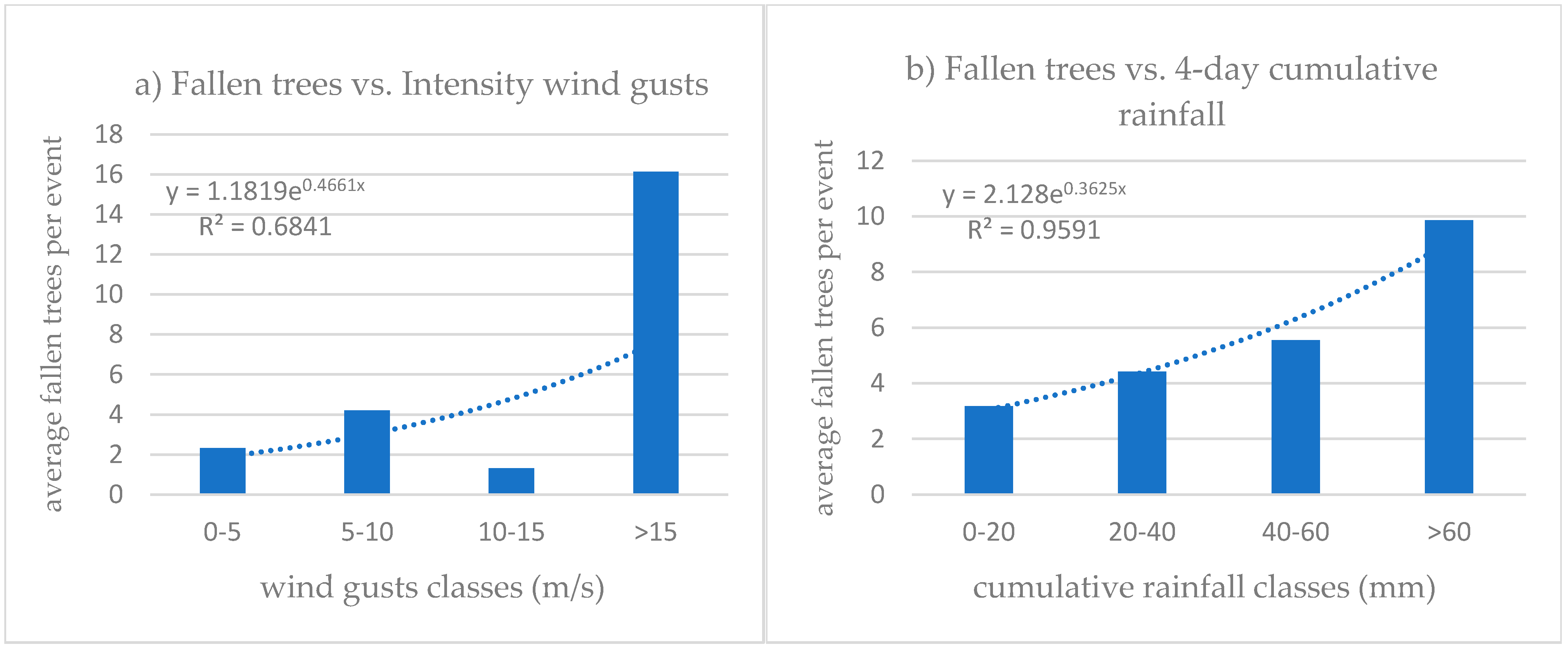
Moving on to consider the distribution of tree failures in relation to the environmental factors that characterized the weather events considered, it is easy to observe how the average number of fallen plants per event increases as the intensity of the wind gusts and the intensity of cumulative rainfall increase (
Figure 6). This observation, while intuitively logical, is substantiated by the linear regressions performed on both graphs, expressed as exponential functions. The resulting R
2 values of 0.6841 and 0.9592, respectively, indicate a good to excellent model fit. The R
2 values range from 0 to 1, with 1 signifying that the predictor variable perfectly explains the response variable without error. In this context, the high R
2 values suggest that the regression models effectively capture the trends in the data as the considered variables (cumulative rainfall intensity and wind gust speed) change. Specifically, the model for wind gust speed (R
2 = 0.9592) shows a particularly strong fit to the observed data.
Performing the Kruskal–Wallis rank sum test on the number of fallen trees and the categories of both cumulative rainfall values and wind gusts, the following results were obtained:
Data related to wind gusts: Kruskal–Wallis chi-squared = 105, df = 4, p-value < 2.2 × 10⁻¹⁶. This indicates a significant difference in the average number of tree falls between at least two categories. Therefore, the wind speed is strongly associated with the rate of tree falls.
Data related to rainfall: Kruskal–Wallis chi-squared = 105, df = 4, p-value < 2.2 × 10⁻¹⁶. The p-value is much lower than 0.05, allowing us to conclude that there are significant differences in tree fall rates among the different categories considered. This means that at least one category has a different tree fall rate to the others.
Spearman’s correlation was then evaluated, considering the number of fallen trees in relation to the rainfall values and wind gusts. A value of Spearman’s rho = 0.051 was obtained, suggesting the absence of correlation. From this, we can state that the two phenomena (rainfall and wind gusts) may affect tree falls differently.
The same analysis, conducted considering events related to tree falls in relation to rainfall values and wind gusts, provided Spearman’s rho value of 0.791. This indicates a strong positive correlation between the number of events linked to rainfall and those linked to wind gusts. In other words, we can say that where we observe a higher number of tree falls related to rainfall, we also observe more tree falls related to wind gusts.
Table 1 presents a comprehensive overview of tree distribution and fall incidents across municipalities. It includes the number of trees and their density per square kilometer in each municipality as of 2018, and the distribution of trees that fell from 2019 to 2022.
The data reveal that the municipalities most significantly affected by tree fall incidents were Venezia insulare, Venezia litorale, and Mestre. This analysis provides insights into the spatial distribution of tree fall events and their relationship to the overall tree population density in different areas of the city.
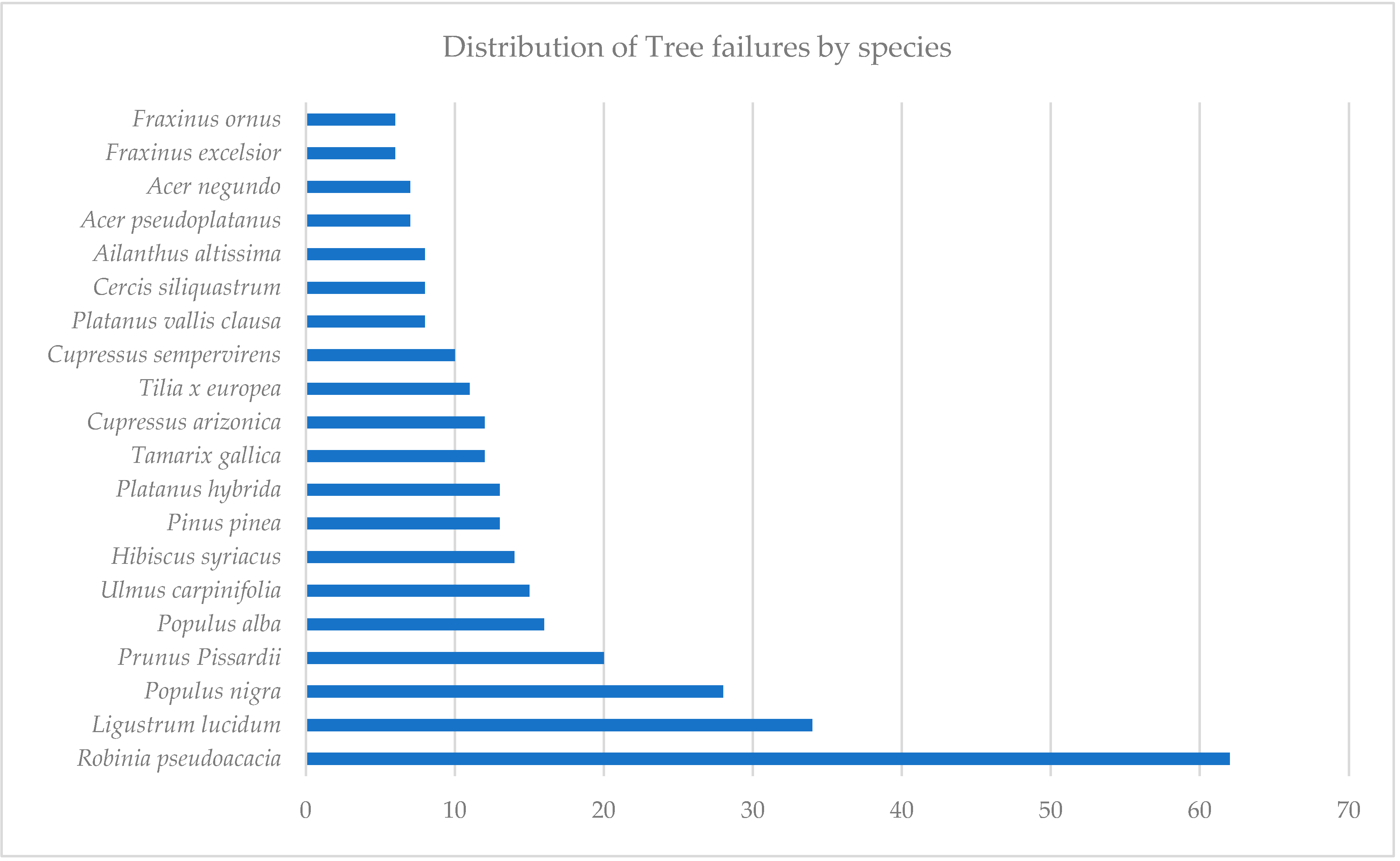
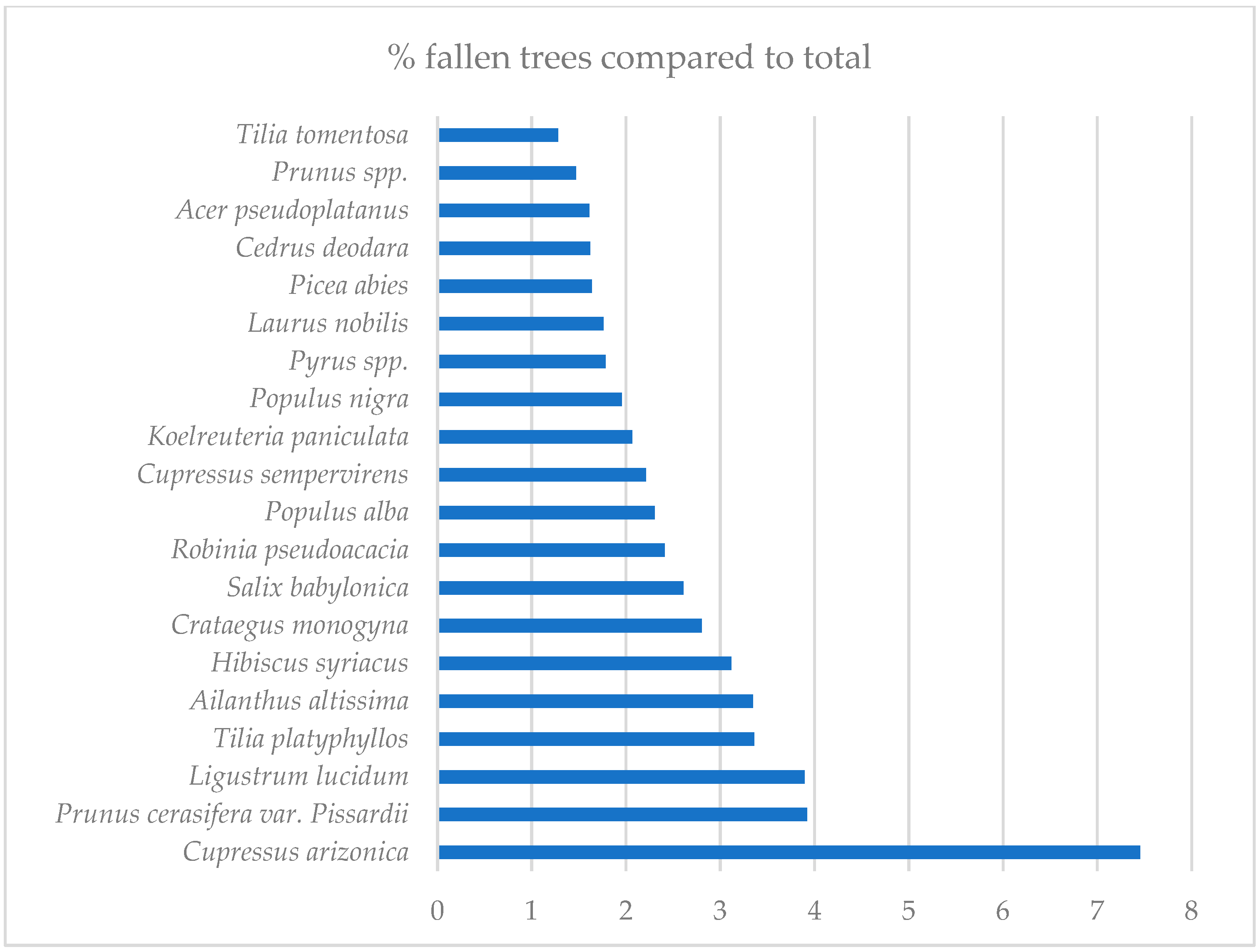
Figure 7 illustrates the distribution of tree failures among different species following severe weather events. The data provide information on which tree species were most susceptible to falling or sustaining damage during severe weather conditions. These findings can be compared with those shown in
Figure 8, which illustrates the percentage of fallen trees in relation to the total number surveyed for each species. For this analysis, we considered only species with at least 100 surveyed specimens (53 out of 74 total species). This criterion excluded some species with high fall rates but low overall numbers, such as
Chamaecyparis lawsoniana (Murray) Parl., which had two out of five specimens fall (40%), and
Broussonetia papyrifera (L.) Vent., with six out of twenty-eight falling (21.4%). In both figures, only the 20 species with the highest values are displayed. This comparative analysis can help inform future risk management and urban forestry strategies.
No significant trends were observed in the distribution of trees related to their social location, growth site conditions (e.g., permeable or impermeable pavement, grassed ground, or containers), or physiological stages.
The spatial autocorrelation test performed among the fallen trees shows that they are not distributed in random order (with k = 1; Moran’s I = 0.35349;
p < 0.001). There is a clear positive spatial autocorrelation in the tree fall dates within approximately 1500 m, as shown in
Figure 9. In contrast, a negative autocorrelation is observed at around 5000 m.
4. Discussion
Multiple factors contribute to the hazards associated with tree collapse. These include senescence, imbalance between aerial and underground systems, physical damage to roots and trunks, and infestation by insects and fungi [
33]. Collectively, these factors can lead to structural failure in trees. The risk of tree fall may further increase when combined with adverse weather conditions [
34].
The prevalence of severe thunderstorms in the area of the City of Venice during the summer months can be attributed to the presence of warm, humid air. This atmospheric condition triggers strong vertical air movements, leading to the formation of cumulonimbus clouds, which are characteristic of thunderstorms. In contrast, differing from the observations in Venice, a similar study conducted in Lisbon, Portugal, found that most tree falls occurred during autumn and winter [
35]. However, it should be noted that this period is precisely characterized by the increased activity of Atlantic disturbances, which bring storms, strong winds, and heavy rainfall to the Iberian Peninsula [
36].
A study conducted in São Paulo, Brazil [
37] revealed that tree fall is significantly influenced by climatic factors, particularly precipitation, wind gusts, and temperature. In this region, tree fall is predominantly a seasonal event, occurring mainly during the wet season. The researchers found that wind gusts have a delayed effect, ranging from days to weeks, which leads to cumulative structural damage in trees. Similarly, rainfall exhibits a delayed impact of 4–16 days during wet seasons, primarily affecting soil stability. These findings suggest that climate conditions can have both immediate and long-term consequences on tree fall through two main mechanisms: accumulated structural damage to the trees themselves and alterations in soil anchorage. This research highlights the complex interplay between climate variables and urban forestry, emphasizing the need for proactive management strategies in cities with similar climatic conditions.
The municipalities most affected in terms of fallen trees per hectare were ‘Venezia insulare’, ‘Venezia litorale’, and ‘Mestre’. The high number of fallen trees in Venezia litorale and Mestre can be attributed to their large tree stock, making it a probabilistic issue (see
Table 1). For the two Venice municipalities (V. insulare and V. litorale), the high number of fallen trees can be explained by their greater exposure to strong wind gusts from the northeast and southeast. In fact, in Venice, the predominant winds are the Bora, a cold and dry wind blowing from the northeast, typically more frequent during autumn and winter, and the Scirocco, a warm and humid wind coming from the southeast, more common in spring and summer [
38]. Trees along the littoral in these areas lacked protection against these wind directions.
The spatial autocorrelation test results reveal a positive autocorrelation in the graph segment from 0 to approximately 1500 m (
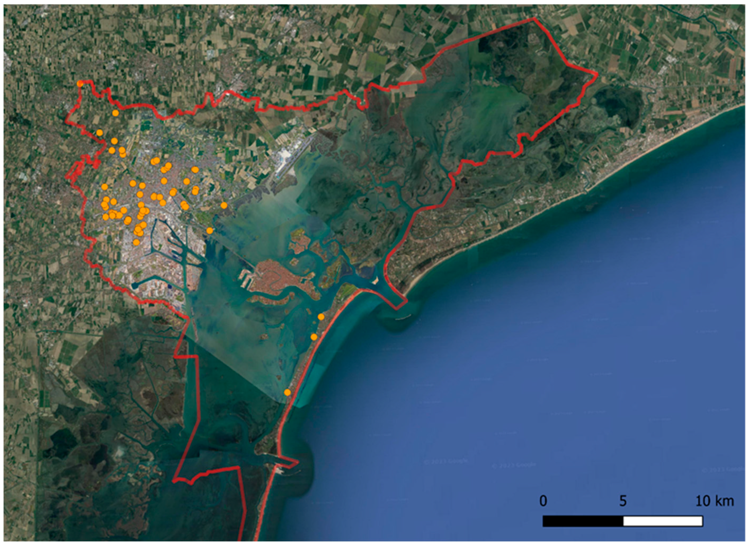
Figure 9). This finding indicates that during an extreme weather event, trees exhibit a higher likelihood of falling in close proximity to one another within a 1500 m radius. For instance, examining the extreme event of 17 August 2021, which resulted in the fall of 83 trees in a single day, we can observe—using the map in
Figure 10—that the fallen trees are predominantly concentrated in the municipalities of Mestre and Marghera. They tend to cluster in groups within a radius of approximately 1 km, with the sole exception being three trees that fell in the Venezia litorale municipality.
The evaluation of the distribution of failure in relation to species established that the five most affected species were the following:
Robinia pseudoacacia L.,
Populus alba L.,
Populus nigra L.,
Ligustrum lucidum W.T.Aiton, and
Prunus cerasifera Ehrh. var.
pissardii (
Figure 7). Interestingly, some of these species, particularly
R. pseudoacacia and the Populus species, are pioneers, which typically implies a fast-growing and adaptable root system that should ensure their stabilization. However, the data obtained do not support this principle. This discrepancy might be explained by considering the wood properties of these species. Despite their pioneer status, many of these trees, especially those in the Populus genus, are known for their relatively soft and brittle wood [
39]. This characteristic makes them more susceptible to wind-induced stress and breakage, even if their root systems are well developed. The high failure rate observed in these species could therefore be attributed to the poor resistance of their wood to strong winds, rather than issues with root anchorage. This finding underscores the importance of considering not only root structure, but also wood strength when assessing a tree’s resilience to severe weather events in urban environments.
Among the species with the highest percentage of falls relative to their total population (
Figure 8),
Cupressus arizonica (or
Hesperocyparis arizonica) (Greene) Bartel stands out notably. These specimens, predominantly 50–60 years old, have often been compromised by diseases. Such infections are frequently linked to improper and severe pruning practices carried out in previous years. This historical mismanagement has likely contributed to their increased vulnerability to storm damage. However, it is important to note that trees in urban environments are subjected to numerous other stressors, including those related to soil conditions. In fact, urban soils generally derive from the accumulation of debris, landfill materials, and excavation remains, which leads to the creation of soils with little organic substance and poor structure, which therefore tend to create a surface crust that causes a reduction in aeration and drainage, as well as a poor water retention capacity [
40,
41]. All these conditions are amplified by soil compaction, typical of city soils, due to the vehicular and pedestrian traffic that populates urban areas. In addition to this, there are also the numerous works to which the soil is frequently subjected in the city, for the construction of infrastructures, for the passage of underground utilities, or for construction digs.
Regarding the selection of optimal tree species for urban environments, while the establishment of comprehensive guidelines is highly desirable, it remains a nuanced and complex challenge. Tree selection must be context-specific, as blanket recommendations without considering local conditions are inappropriate and potentially counterproductive Reference. [
42] developed a list of relative wind resistances for tropical and subtropical tree species based on a survey of 85 arborists, scientists, and urban foresters. However, the selection process should involve a comprehensive analysis of the local climate conditions, soil characteristics, urban infrastructure, potential future climate scenarios, and the intended ecosystem services. Each urban environment presents unique challenges and opportunities, making it crucial to tailor tree species choices to the specific needs and constraints of each location. Furthermore, the dynamic nature of urban environments and the ongoing impacts of climate change necessitate a flexible and adaptive approach to urban forestry. What might be an ideal species choice today could become less suitable in the future, underscoring the importance of diversity in urban tree populations and continuous monitoring and research in this field [
43,
44,
45].
While no statistically significant trend emerged from the data, the analysis of tree fall distribution in relation to social location revealed noteworthy patterns. The majority of affected trees were concentrated in two primary areas: roadside rows and associated groups typically found in parks. These locations are characterized by high volumes of vehicular and pedestrian traffic, raising significant safety concerns for both people and property. This finding underscores the importance of targeted maintenance and risk assessment strategies in these high-traffic urban areas to mitigate the potential hazards associated with tree falls [
46].
The analysis of fallen trees in relation to their development stage takes into account the age of the plant at the time of its fall. It emerges that most of the fallen trees belong to the four and five classes (according to Raimbault’s model [
29]), which roughly correspond to the average age of the individual. This can be attributed to the fact that younger trees retain elastic properties that allow them to absorb the forces exerted by the winds [
47]. In contrast, mature and senescent trees are largely absent in urban areas due to the continuous environmental stresses they face, which ultimately compromise their longevity.
Despite our efforts, a comprehensive analysis of the propensity to failure class could not be completed due to significant data inconsistencies and gaps in the available information. This analysis would have yielded crucial insights for developing targeted tree management and maintenance strategies [
34]. The absence of this vital information hinders our ability to optimize urban forestry practices and implement proactive risk mitigation measures. Future efforts should prioritize improving data collection and management processes to enable more robust analyses and informed decision-making in urban tree care.
Our findings for the case study area indicate that tree felling incidents are predominantly concentrated during the summer season. To address this local issue, we recommend implementing strategic felling plans that prioritize the removal of highly vulnerable specimens, such as severely decaying trees, before the onset of summer. This proactive approach would eliminate easy targets for wind-induced falls. The strategy should be part of a comprehensive tree management program. Such a program should encompass best practices, including the following:
Careful selection of high-quality nursery stock;
Proper tree planting techniques;
Appropriate maintenance of trees, especially mature ones;
Strict adherence to Tree Protection Zone (TPZ) guidelines [
48].
By combining targeted pre-summer felling with these long-term management practices, we can significantly enhance the resilience and safety of urban forests.
When applying these findings to other cities, several factors must be considered for effective adaptation. Climate, urban forest composition, population density, and available resources all play crucial roles in shaping management strategies:
Cities with different climates might need to adjust the intervention period, focusing on seasons that pose the greatest risk to tree stability in their specific context;
The composition of the urban forest also plays a crucial role, as different tree species may have varying levels of resistance to wind or drought, necessitating tailored management strategies;
Urban density is another factor to consider, with more densely populated areas potentially requiring more frequent interventions and intensive monitoring, especially in high-pedestrian-traffic zones;
Available resources will inevitably shape the scope and pace of implementation, with some cities needing to focus on critical areas first before expanding their efforts.
Community engagement can be a valuable asset in urban forest management. Involving citizens in tree care and monitoring through “citizen science” programs can extend the reach of official efforts and foster a sense of shared responsibility for urban greenery [
49]. The integration of advanced technologies, such as remote sensing and geographic information systems (GISs), can significantly enhance monitoring and management capabilities, though the specific applications may vary based on each city’s needs and resources [
50].
To ensure the effective implementation of these urban forestry strategies, it is essential to adopt a structured and collaborative approach. First, it is advisable to develop a phased approach, prioritizing and implementing these recommendations over time, in line with budget cycles and existing municipal planning processes [
51]. This will allow for a smoother and more sustainable transition towards improved urban forest management practices. Furthermore, it is crucial to establish key performance indicators (KPIs) to monitor the progress and effectiveness of these initiatives. By creating measurable targets for tree health, fall incidents, and public engagement, administrations will be able to assess the impact of their actions and make adjustments where necessary [
52,
53]. Finally, fostering public–private partnerships can significantly amplify the impact of these efforts. Engaging local businesses, universities, and community organizations in urban forestry initiatives can expand the range of resources and expertise available, leading to more robust and sustainable outcomes.
5. Conclusions
This study successfully identified a positive correlation between tree falls and both wind gust intensity and cumulative rainfall. It also found that most failures occurred during summer months, associated with severe thunderstorms due to warm, humid air. Conclusions regarding meteorological factors are logical: as the intensity of wind gusts and cumulative rainfall increases, so does the number of tree falls. While we cannot control these factors, preventive measures can be integrated into municipal workflows:
Develop a severe weather response protocol: Municipalities can create a standardized procedure for pre-emptive tree inspections and potential temporary closures of high-risk areas during severe weather events;
Implement a public awareness campaign that integrates tree fall risk information into existing municipal communication channels (e.g., city websites, social media, and local news partnerships) to improve safety measures and preparedness;
Establish a data-driven tree management system using GISs and tree inventory software to map and monitor high-risk trees, allowing for targeted maintenance and risk mitigation.
The spatial distribution of tree failures revealed varying patterns across different municipalities. In areas with a large tree stock, the high number of fallen trees can be partially attributed to a probabilistic effect—more trees inherently lead to more potential failures. However, for the Venice municipalities, which are more exposed to strong wind gusts, the elevated incidence of tree falls is likely due to their unique geographical position. The lack of natural windbreaks in these coastal areas leaves trees more vulnerable to the prevailing winds, especially during severe weather events.
The results of this study show that the most susceptible species are those with low-strength wood, such as Robinia pseudoacacia and Populus species. However, the high failure rate is likely not solely due to inherent wood properties, but is probably also related to the presence of diseases (e.g., wood rot), often resulting from historical mismanagement (e.g., improper pruning and root damage). This highlights the complex interplay between species characteristics, environmental factors, and human interventions in determining tree stability in urban environments. Future urban forestry strategies should consider both species selection and long-term management practices to enhance overall tree resilience. To enhance the species selection process, a context-specific tree species selection guide should be created. This involves developing a municipal guideline that takes into account local climate, soil conditions, and urban stressors to inform tree planting decisions. Additionally, implementing a soil quality assessment and improvement program is essential. This program should integrate regular soil testing and amendment practices into urban forestry management to address poor soil conditions that may compromise tree health. Lastly, establishing an interdepartmental urban forestry task force can foster collaboration between urban planning, parks and recreation, and public works departments. This collaboration ensures a holistic consideration of tree-related issues in all urban development projects, ultimately leading to more successful and sustainable urban forests.
By strategically implementing these recommendations, municipalities can carry out the following:
Enhance urban sustainability through improved tree management practices;
Create safer and more livable urban spaces;
Maximize the benefits of urban green spaces (e.g., improved air quality, reduced heat island effects, and enhanced biodiversity);
Mitigate potential ecosystem disservices associated with urban trees.
In conclusion, by adopting this comprehensive approach, cities can not only improve the health and resilience of their urban tree stock, but also create greener, healthier, and more livable communities for all residents.


