
A Broader View of Conservation: Mapping Nature and Culture of Working Lands in the Texas Hill Country


Abstract
1. Introduction
2. Methods
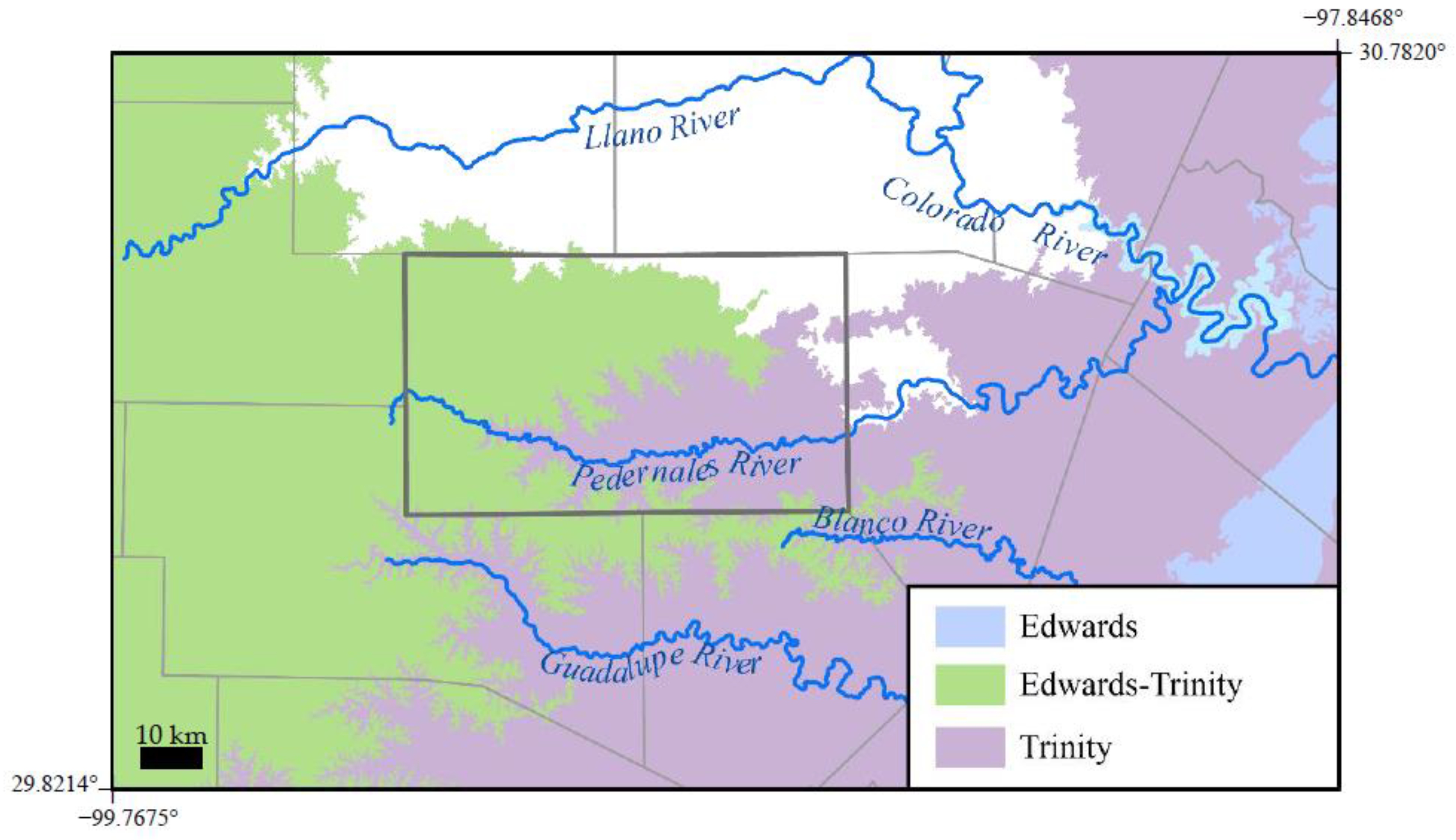
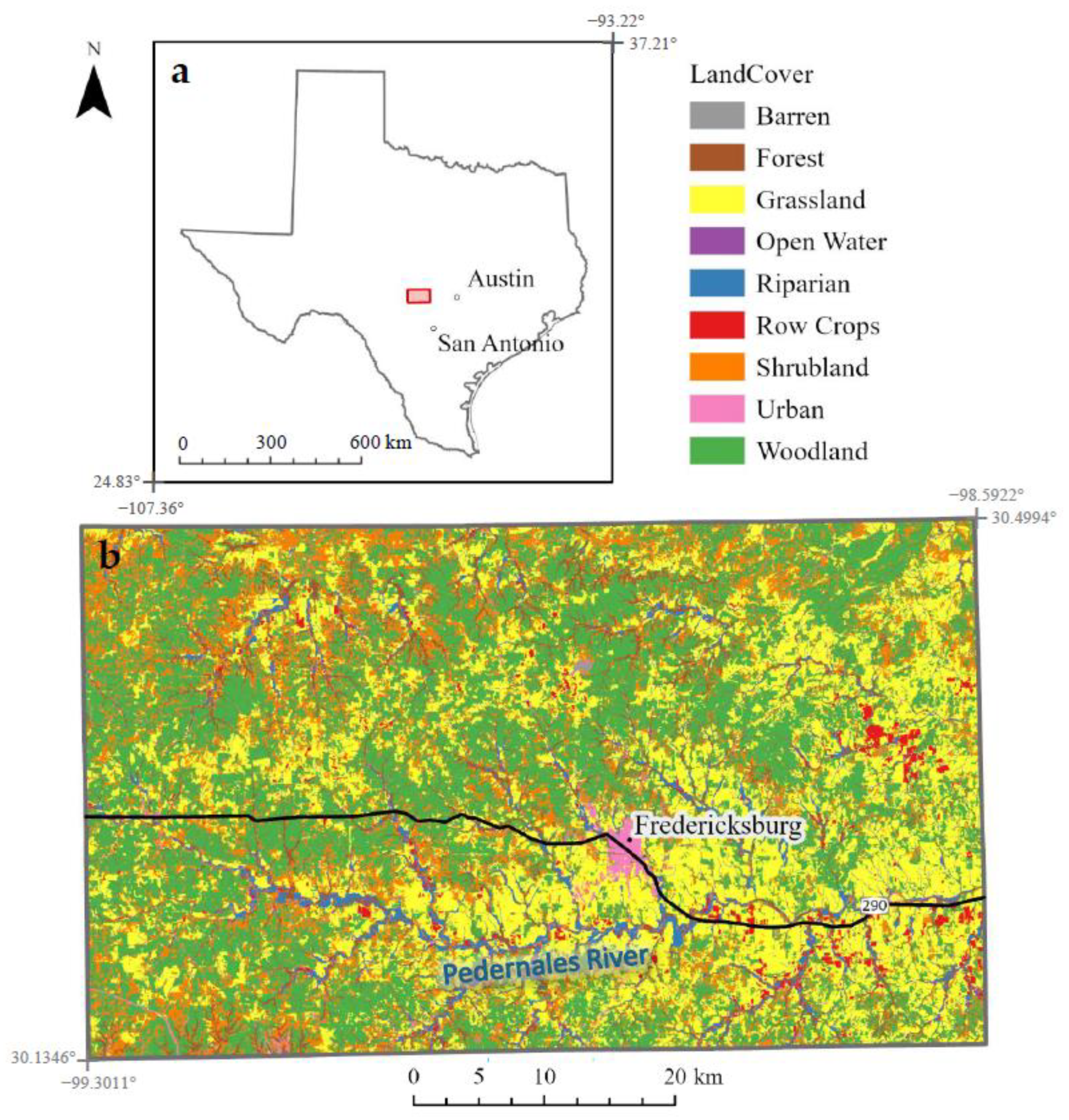
2.1. Study Area
2.1.1. Gillespie County, Texas, USA
2.1.2. Hershey Ranch
2.2. Conceptual Framework
2.3. County Inventory of Benefits
2.3.1. Data
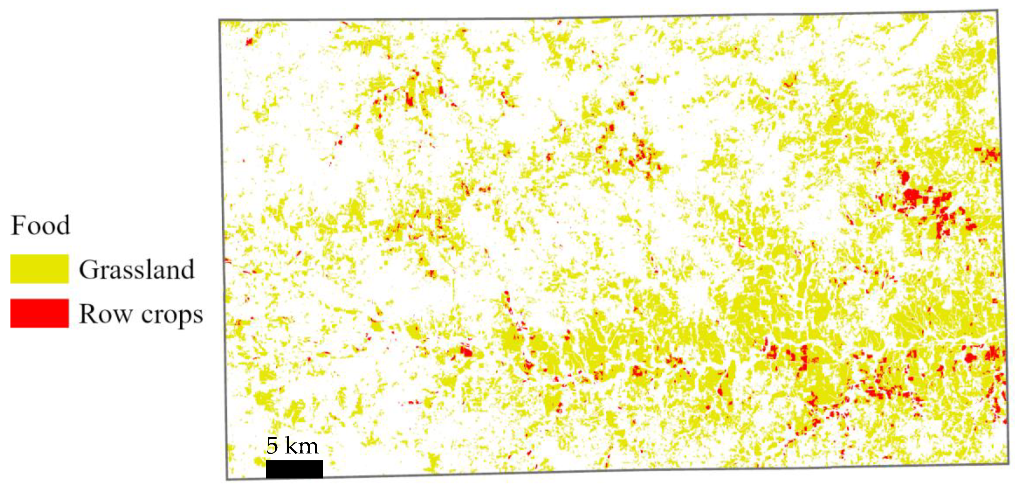
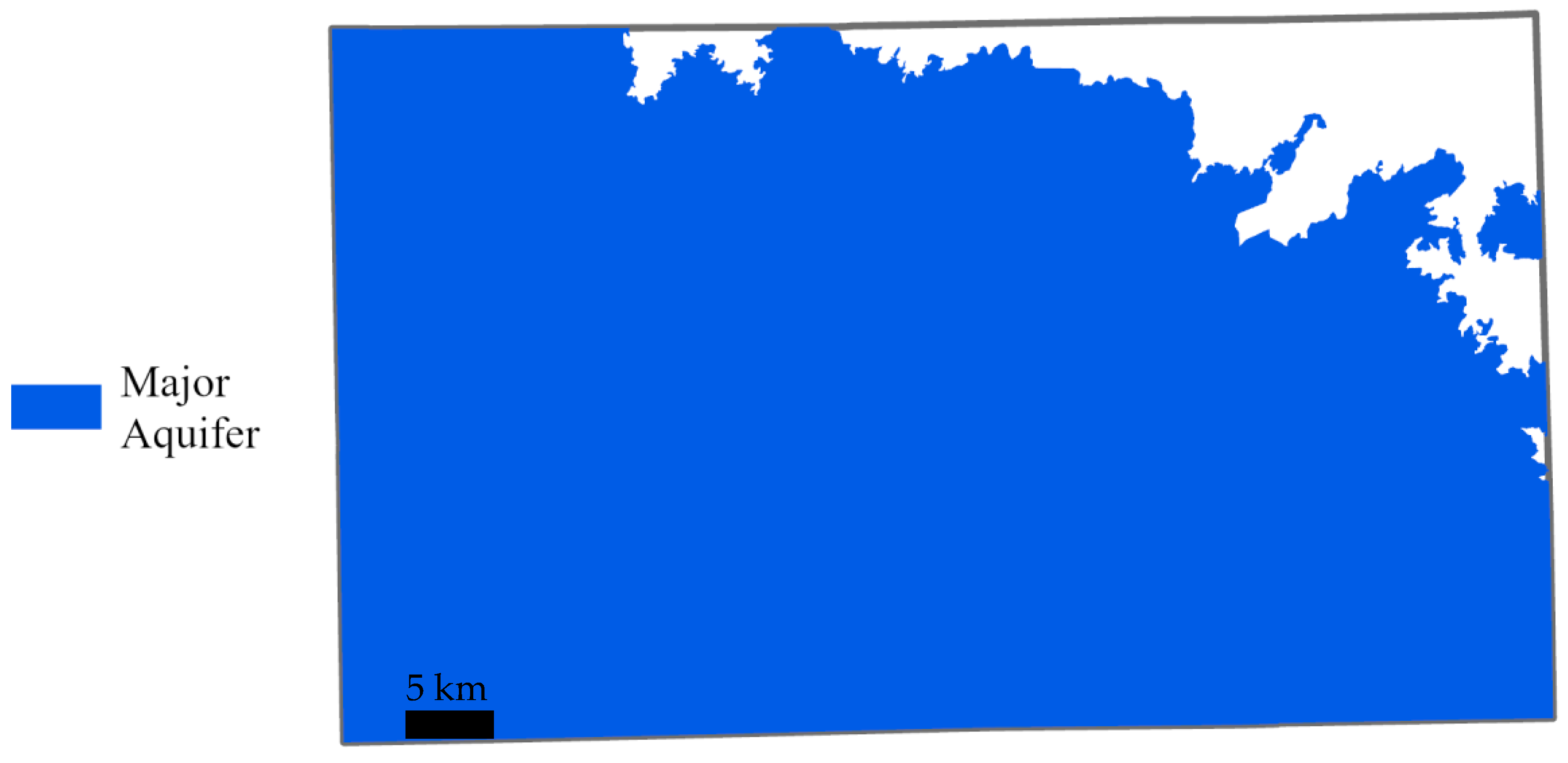
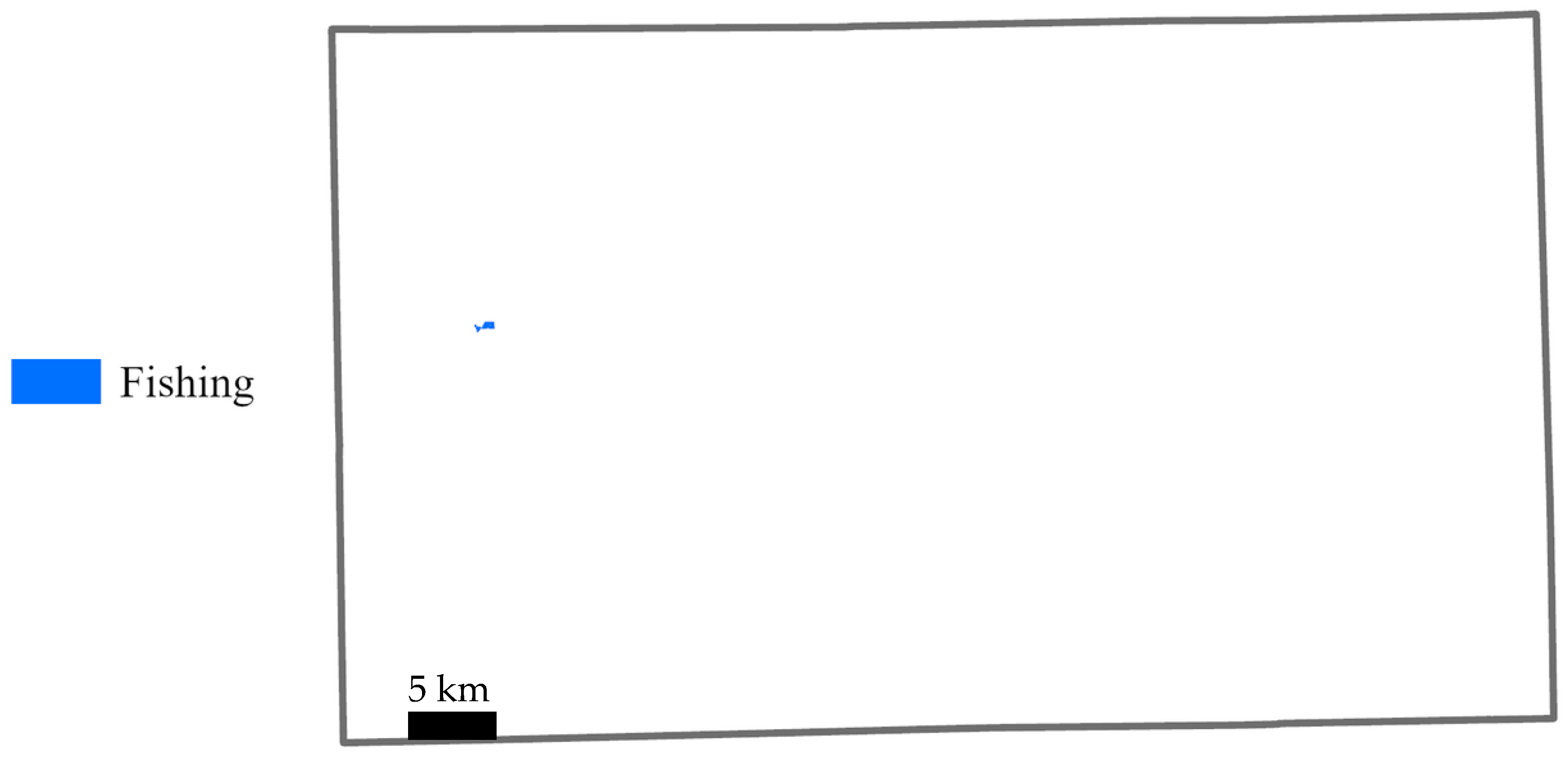
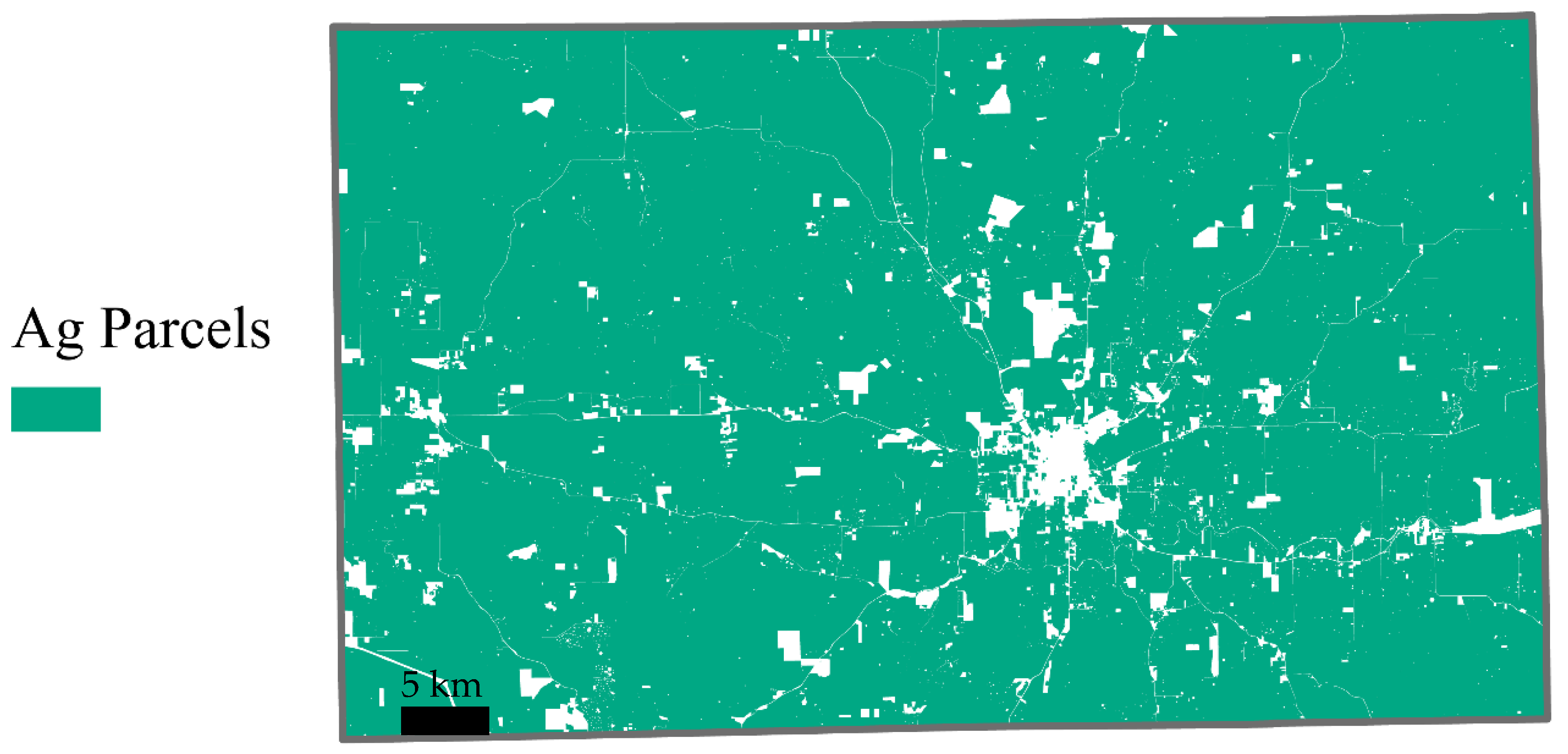
2.3.2. Provisioning Benefits
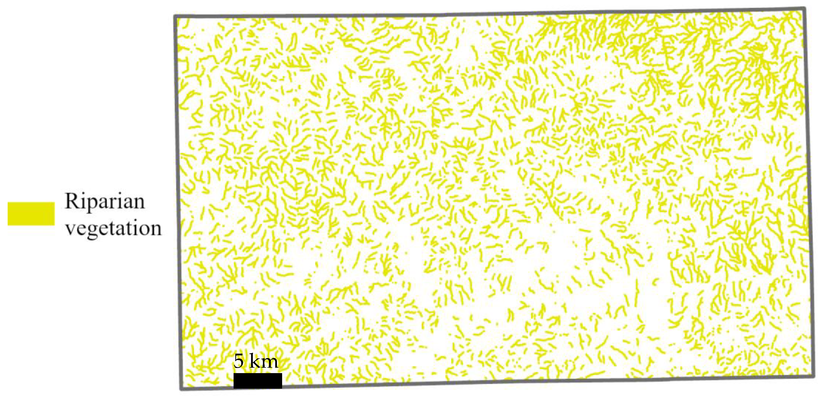
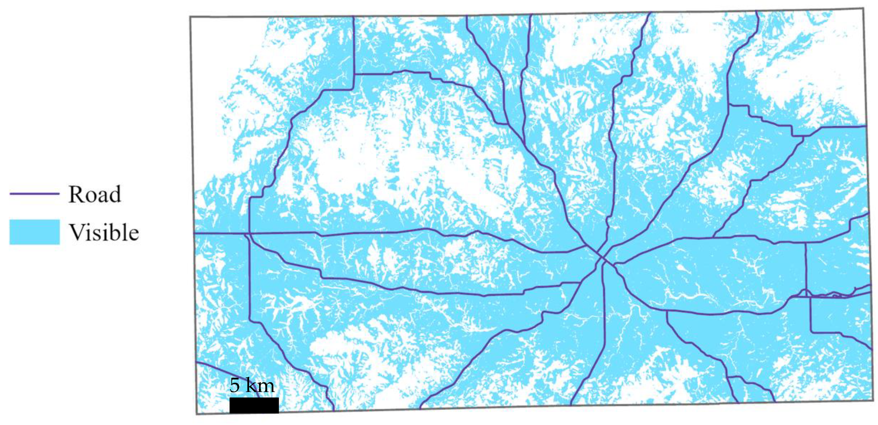
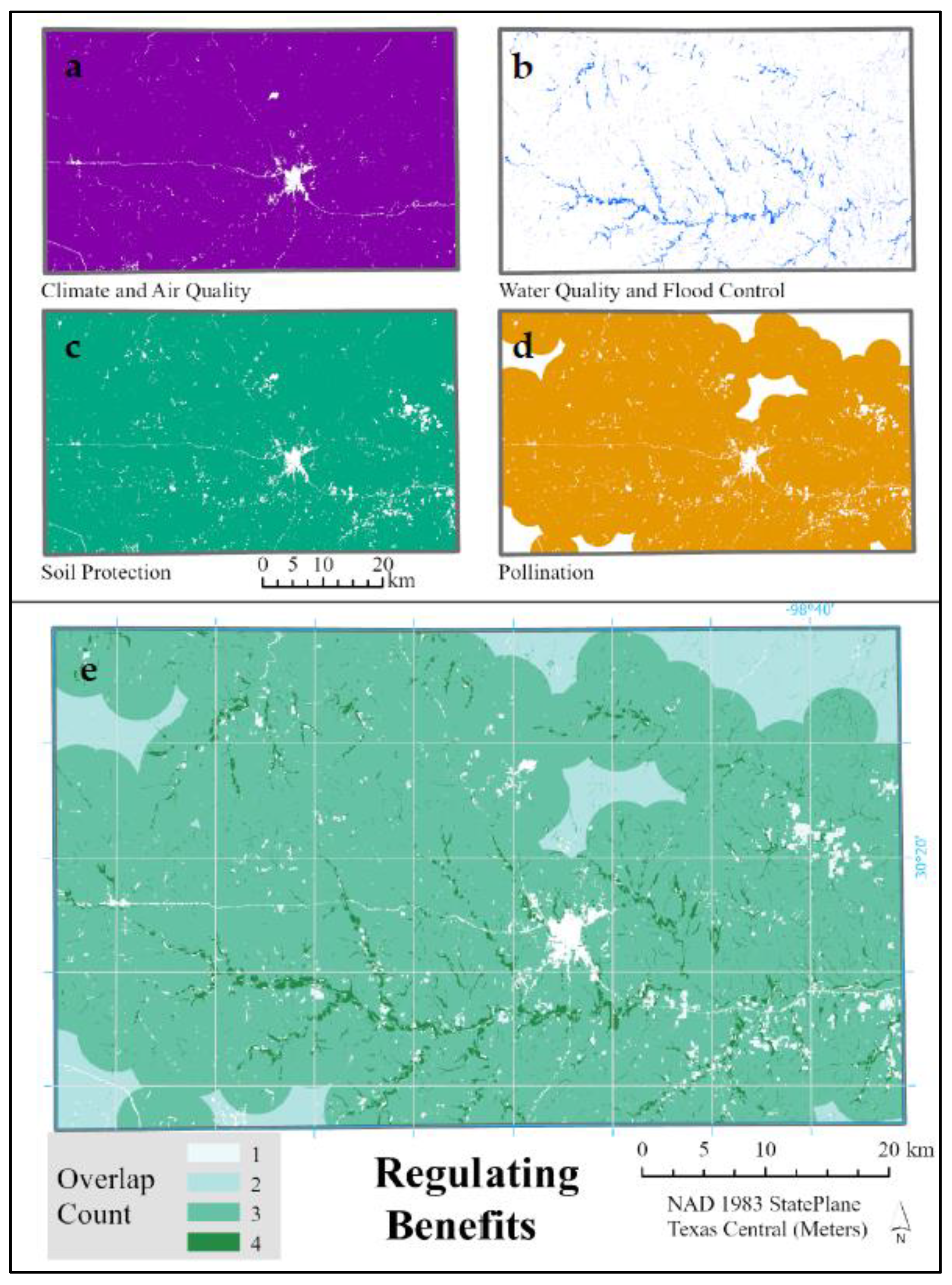
2.3.3. Regulating Benefits
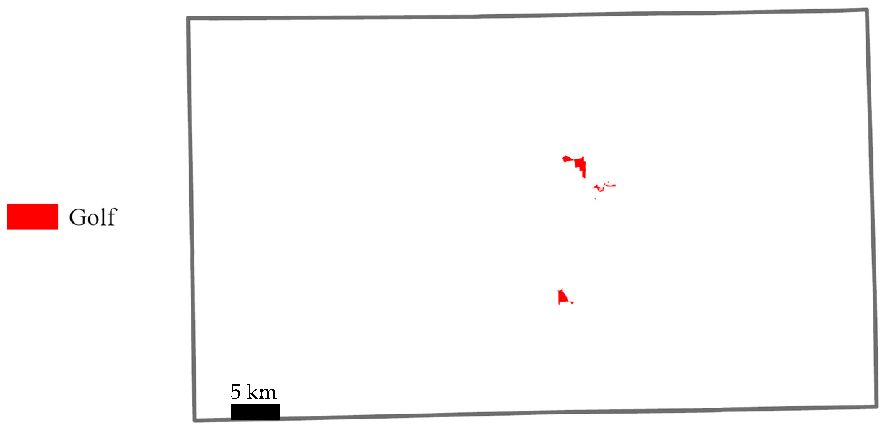
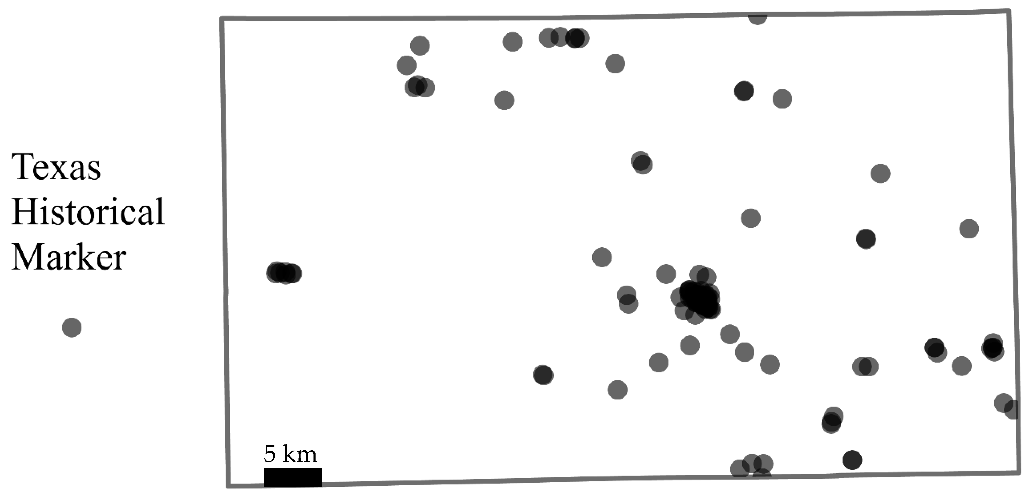
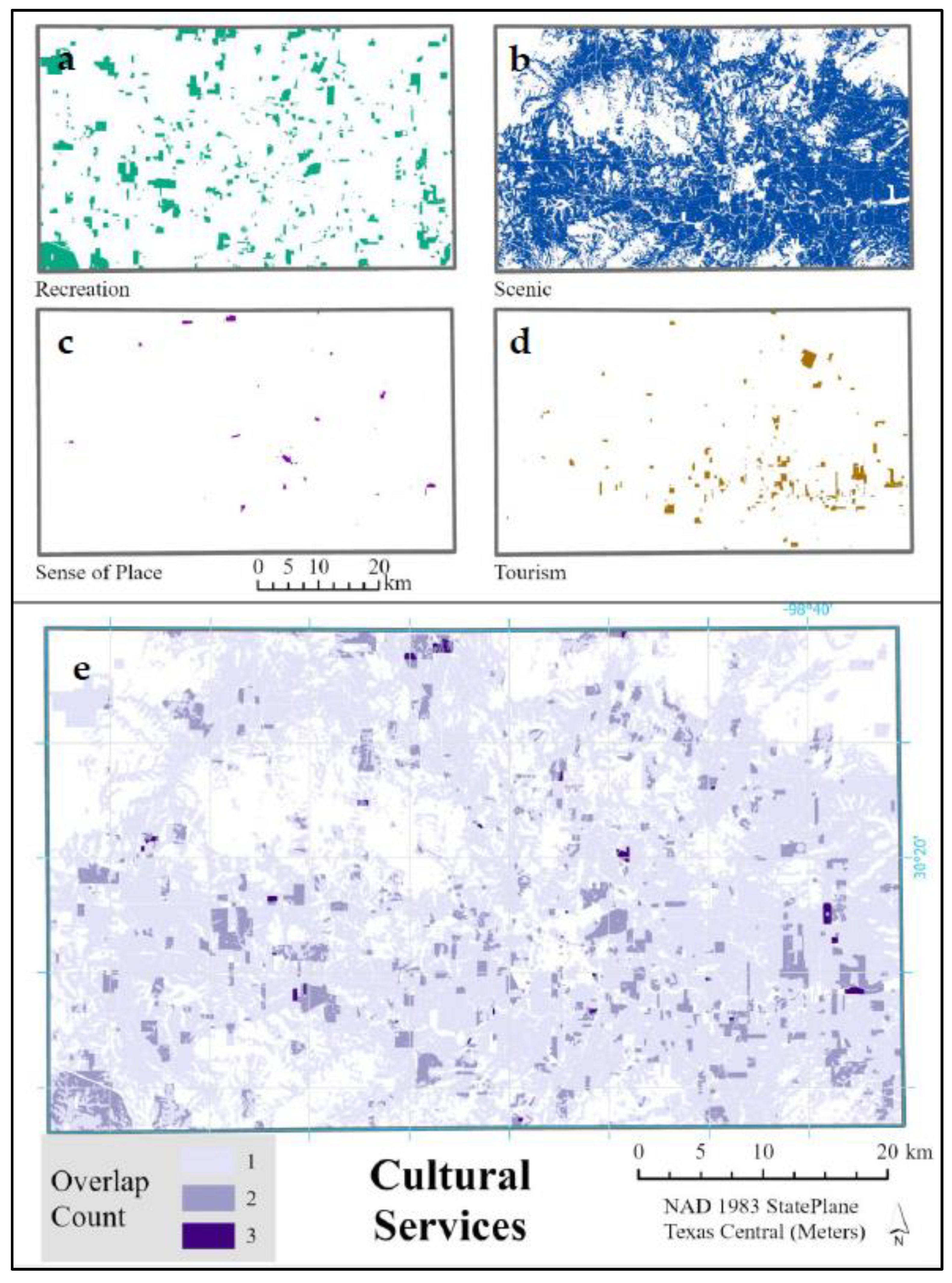
2.3.4. Cultural Benefits
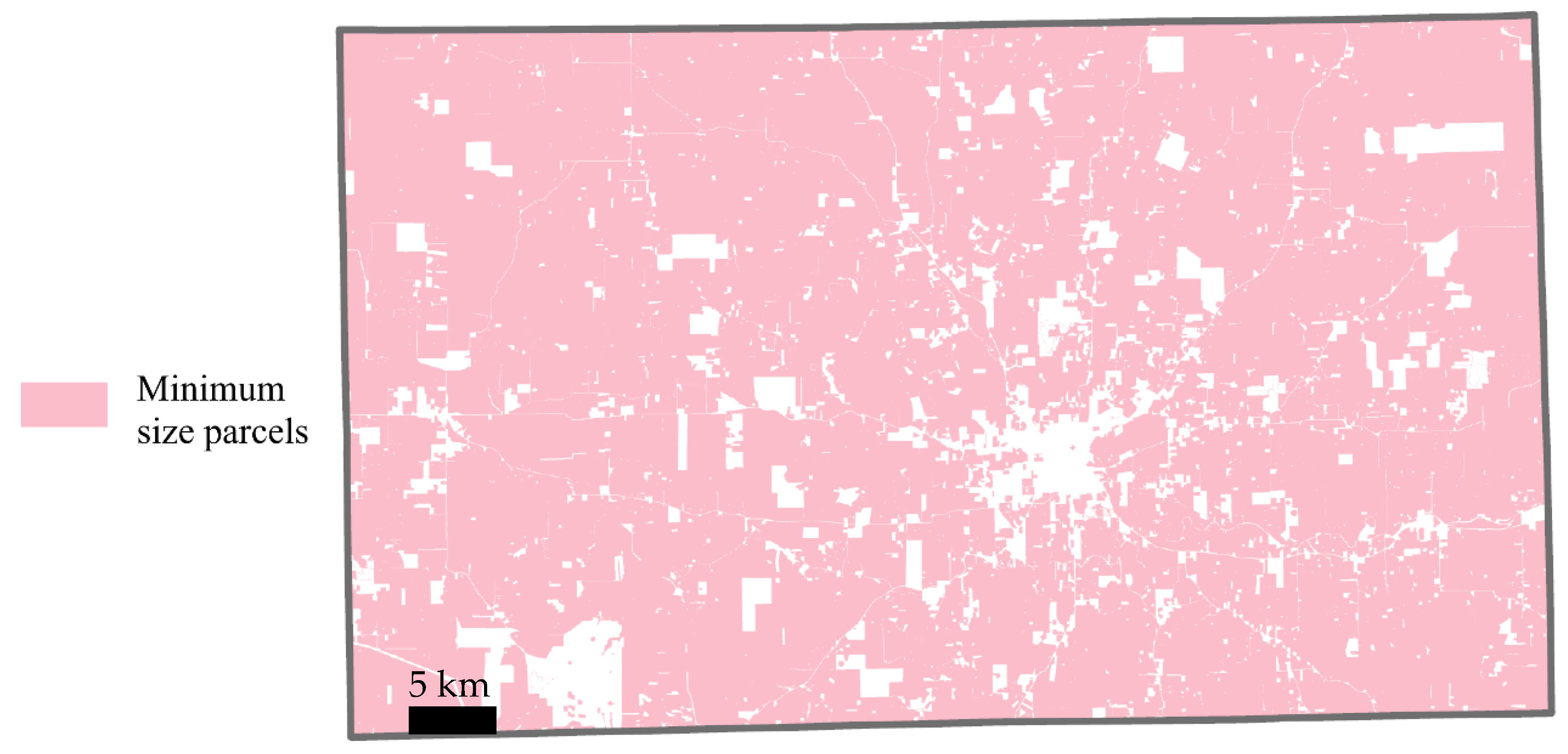
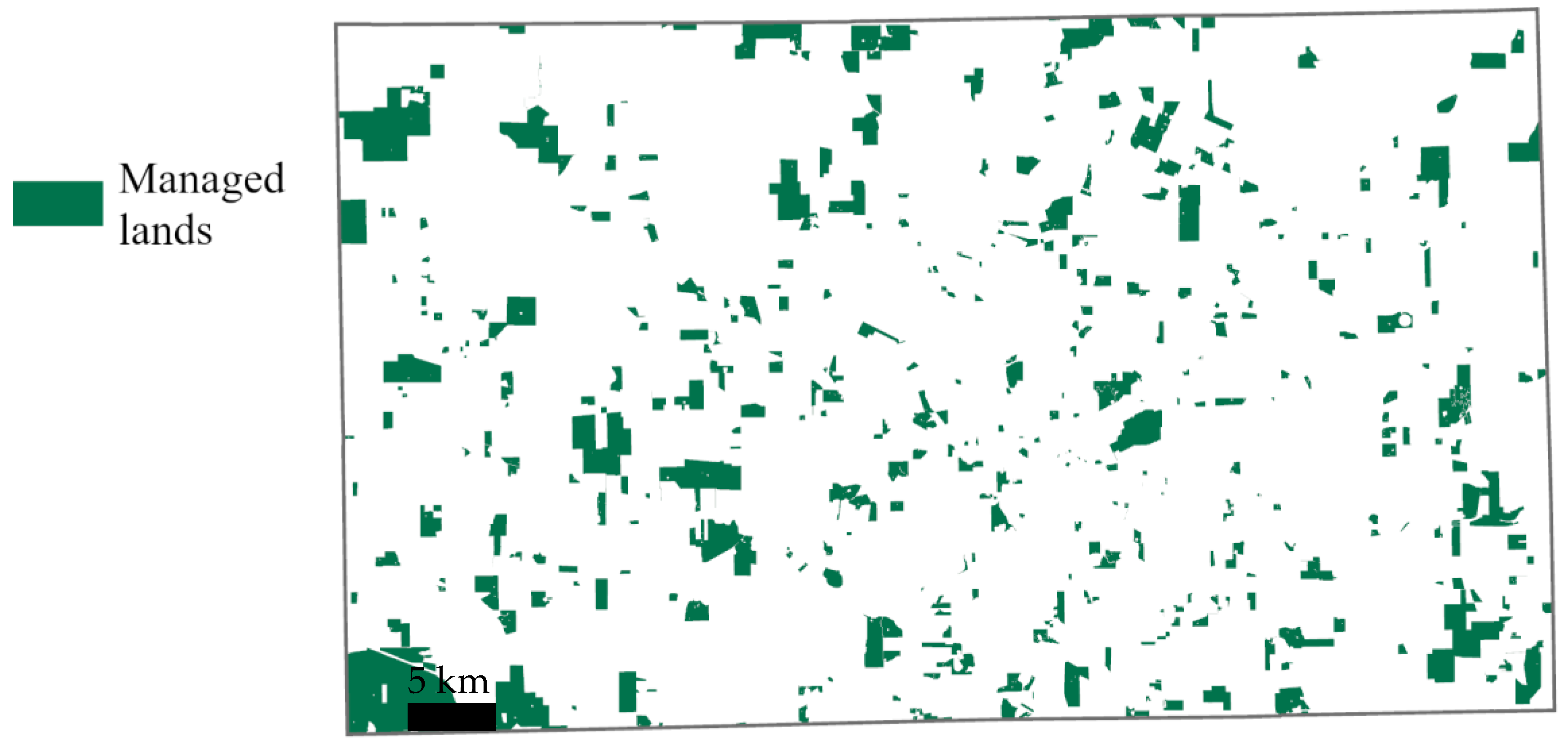
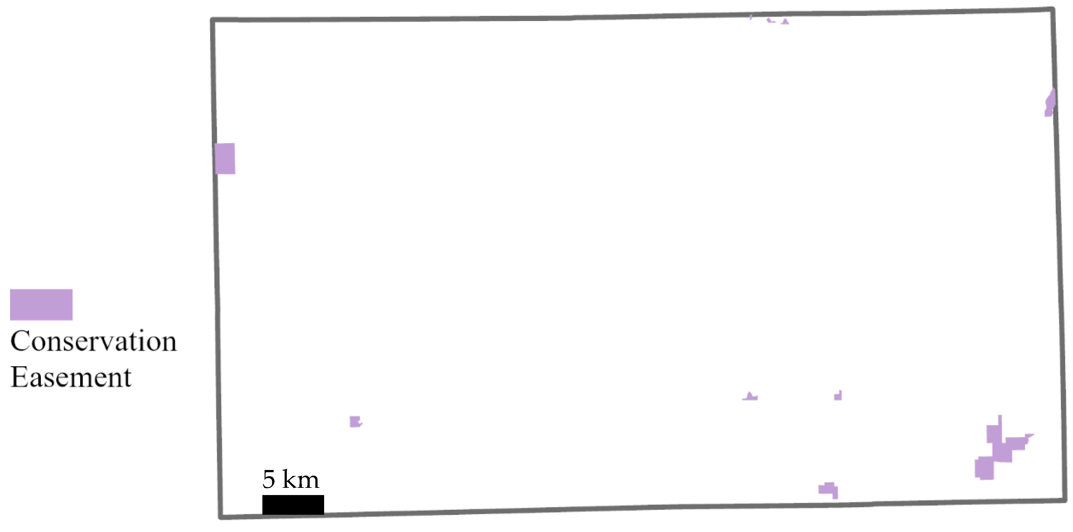
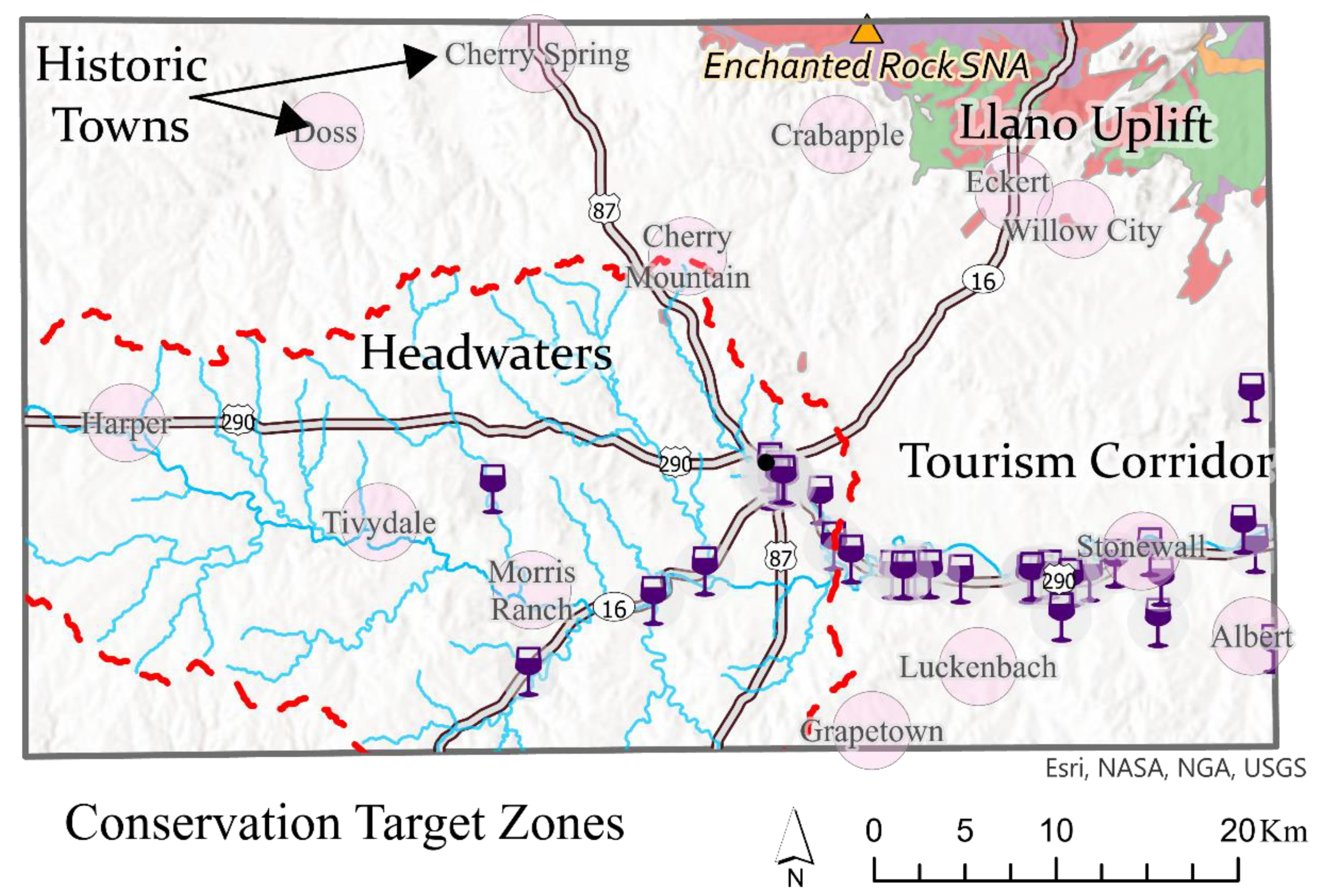
2.4. Mapping of Conservation Target Zones
3. Results
3.1. Hershey Ranch Local Knowledge
3.2. County-Scale Benefits
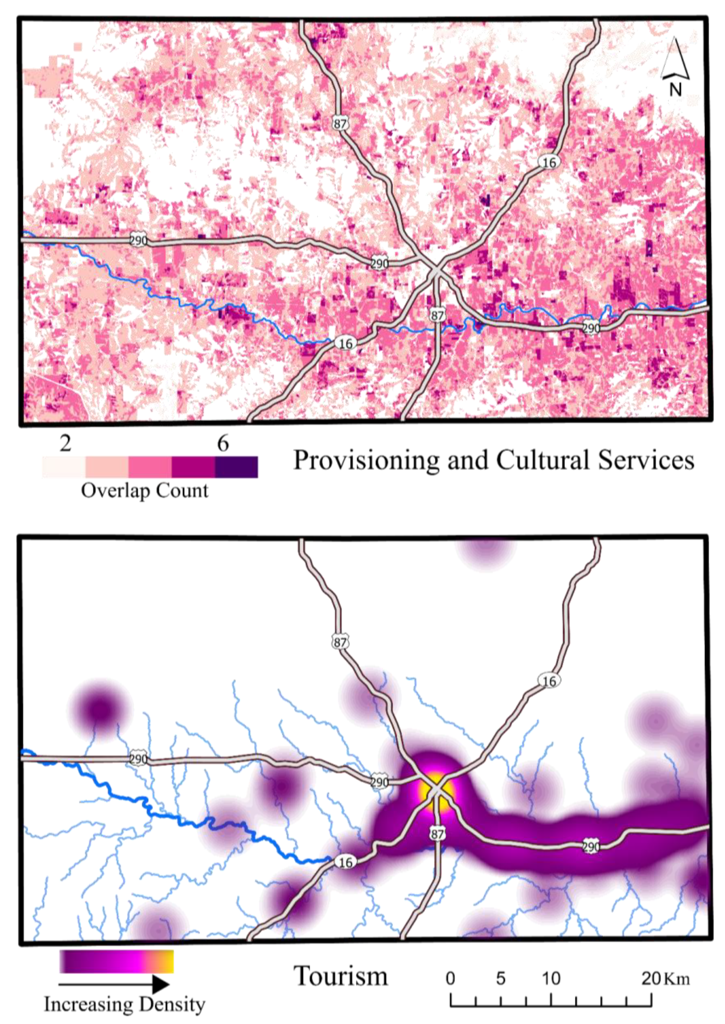
3.2.1. Provisioning ES Benefits
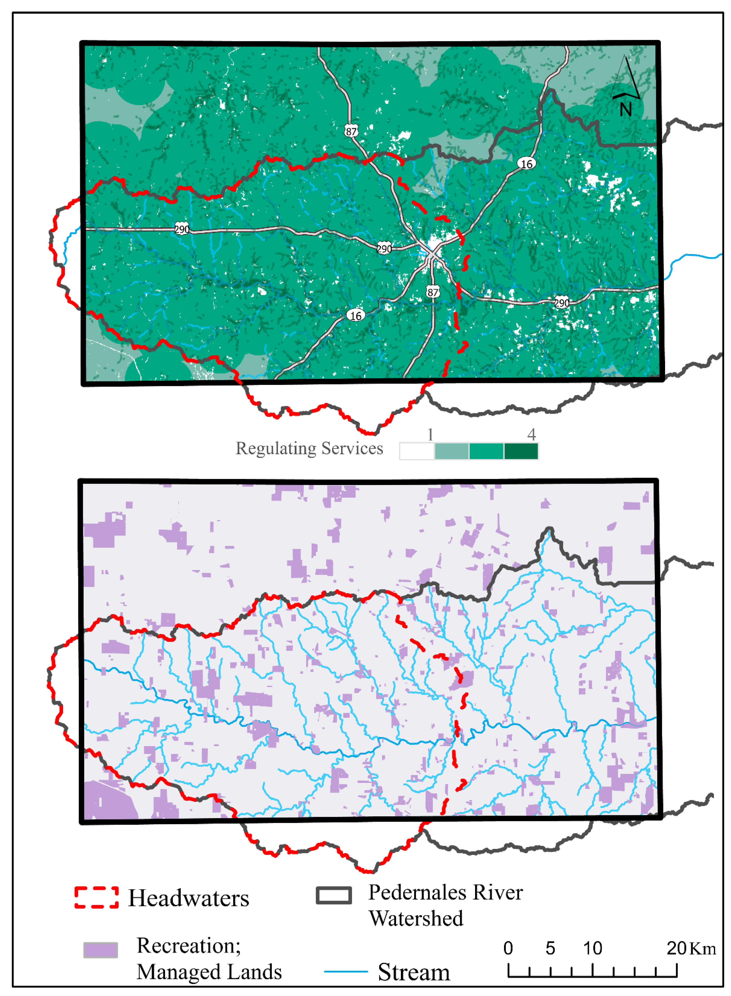
3.2.2. Regulating ES Benefits
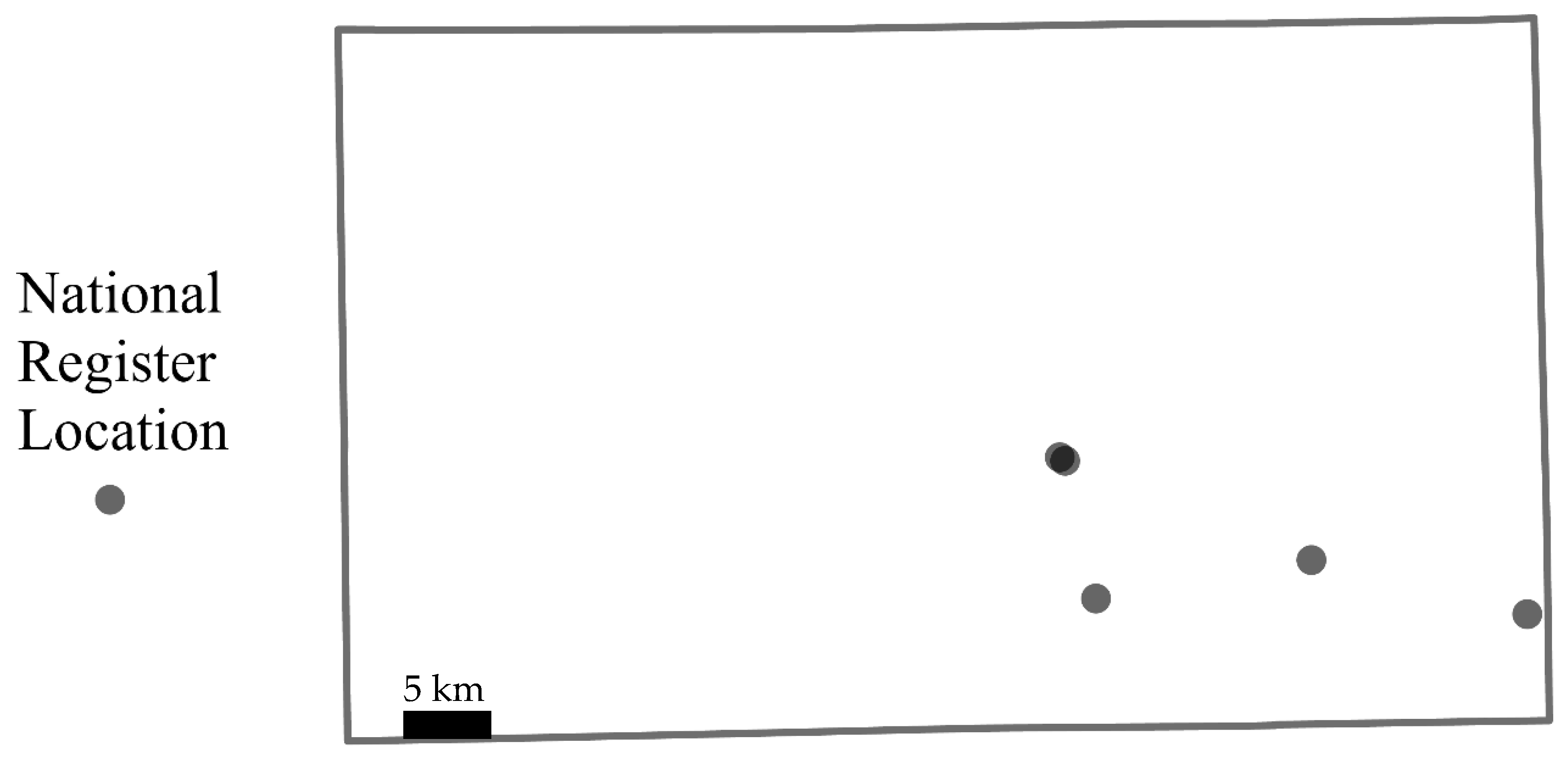
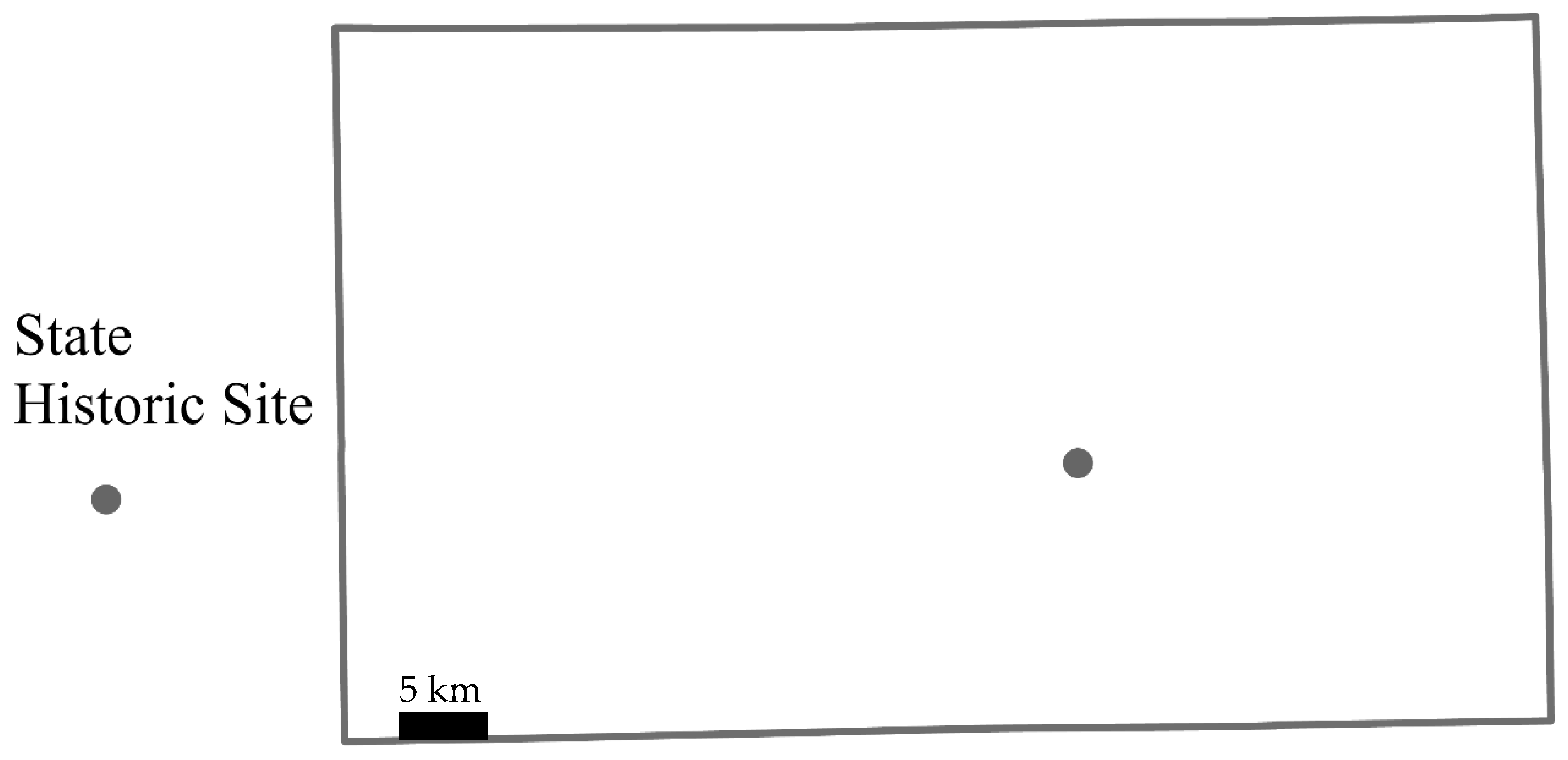
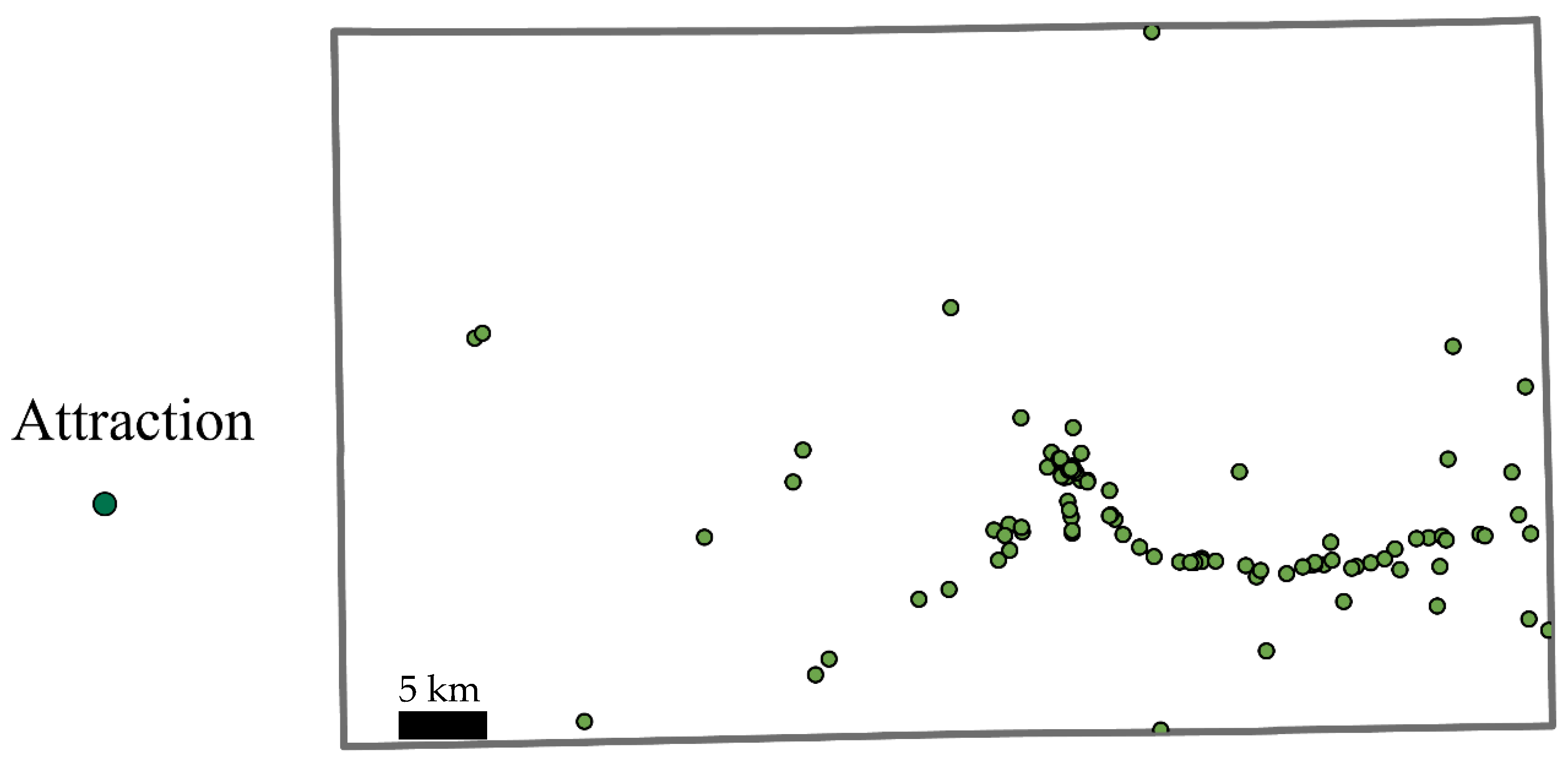
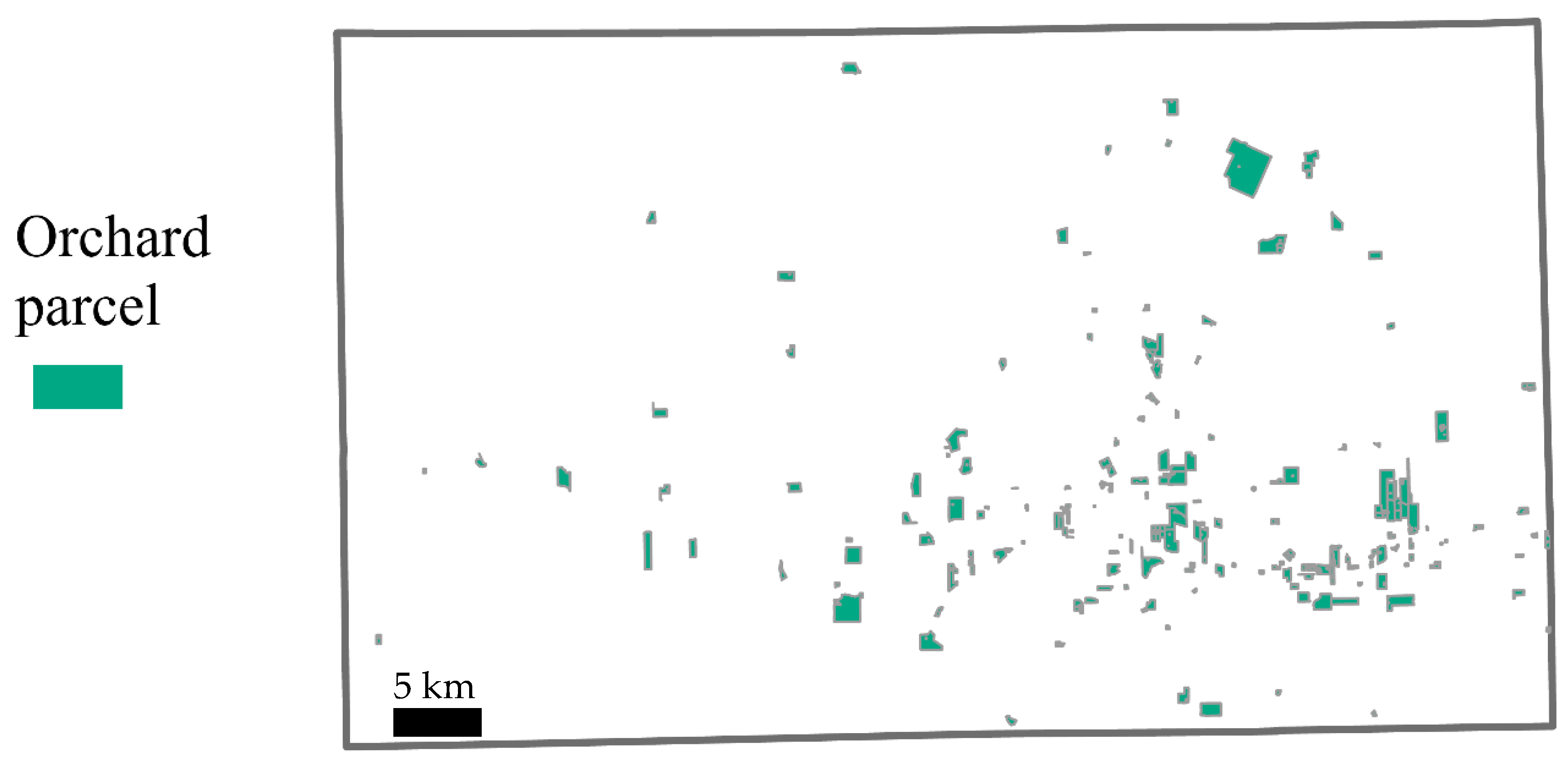
3.2.3. Cultural ES Benefits
3.2.4. Summation and Summary of Benefits for Gillespie County
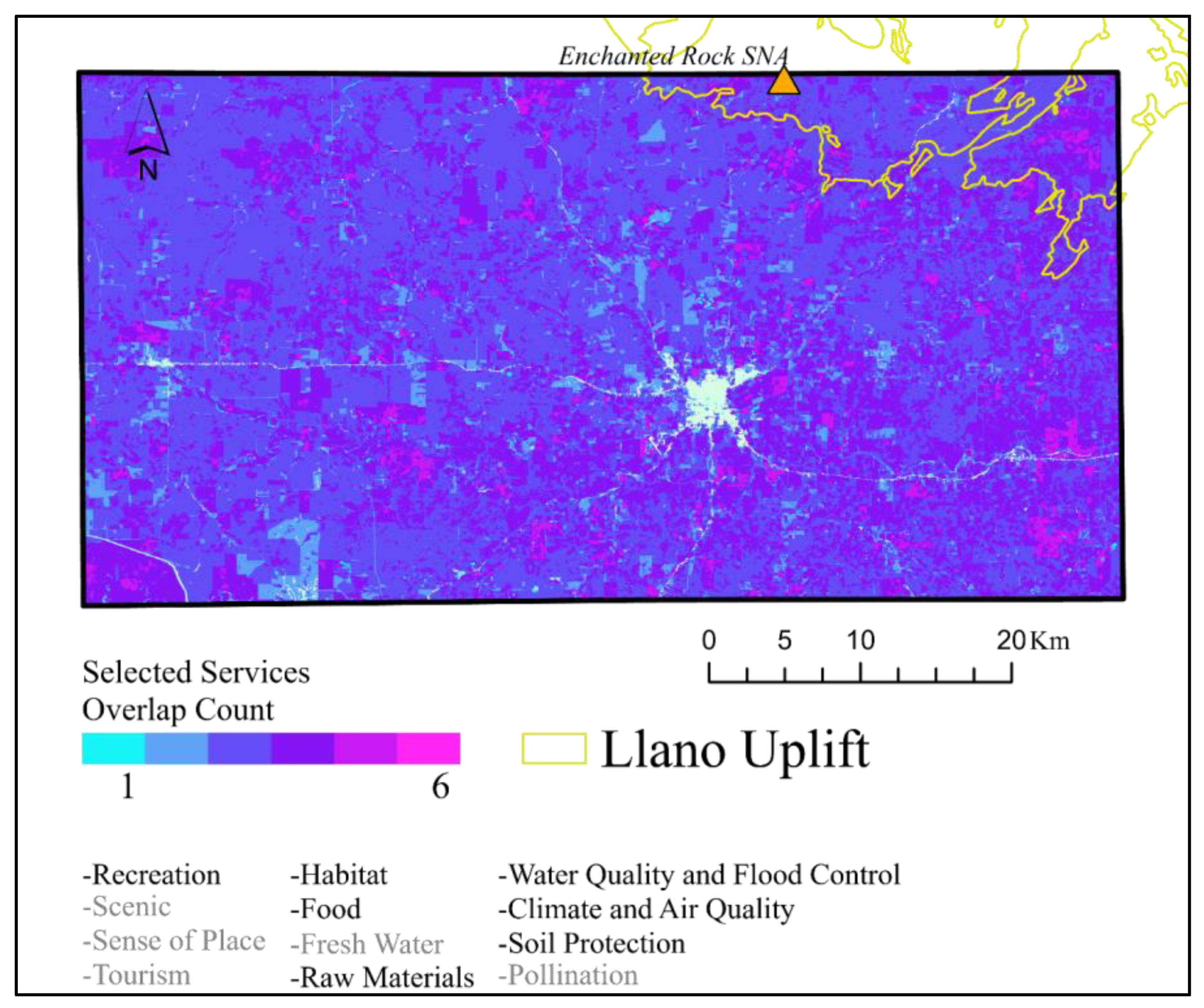
3.3. Conservation Target Zones
4. Discussion
4.1. Multi-Dimensional Conservation Challenges and Opportunities
4.1.1. Tourism
4.1.2. Protecting Land for Water
4.1.3. Heritage Hubs
4.1.4. Working (Ranches) for Conservation?
4.2. Context, Cautions, and Limitations
5. Conclusions
Author Contributions
Funding
Data Availability Statement
Acknowledgments
Conflicts of Interest
Appendix A


References
- DeFries, R.S.; Foley, J.A.; Asner, G.P. Land-use choices: Balancing human needs and ecosystem function. Front. Ecol. Environ. 2004, 2, 249–257. [Google Scholar] [CrossRef]
- Foley, J.A.; DeFries, R.; Asner, G.P.; Barford, C.; Bonan, G.; Carpenter, S.R.; Chapin, F.S.; Coe, M.T.; Daily, G.C.; Gibbs, H.K.; et al. Global Consequences of Land Use. Science 2005, 309, 570–574. [Google Scholar] [CrossRef]
- Bigelow, D.; Borchers, A. Major Uses of Land in the United States, 2012; 178, U.S.; Department of Agriculture, Economic Research Service: Washington, DC, USA, 2017. [Google Scholar] [CrossRef]
- Ramankutty, N.; Graumlich, L.; Achard, F.; Alves, D.; Chhabra, A.; DeFries, S.R.; Foley, A.J.; Geist, H.; Houghton, A.R.; Goldewijket, K.K.; et al. Global Land-Cover Change: Recent Progress, Remaining Challenges. In Land Use and Land Cover Change: Local Processes and Global Impacts; Geist, H., Lambin, F.E., Eds.; Springer: Berlin/Heidelberg, Germany, 2006; pp. 117–135. [Google Scholar] [CrossRef]
- Ramankutty, N.; Mehrabi, Z.; Waha, K.; Jarvis, L.; Kremen, C.; Herrero, M.; Rieseberg, L.H. Trends in Global Agricultural Land Use: Implications for Environmental Health and Food Security. Annu. Rev. Plant Biol. 2018, 69, 789–815. [Google Scholar] [CrossRef]
- Kremen, C.; Merenlender, A.M. Landscapes that work for biodiversity and people. Science 2018, 362, 6412. [Google Scholar] [CrossRef]
- Wilson, E.O. Half Earth: Our Planet’s Fight for Life; Liveright Publishing Corporation: New York, NY, USA, 2016. [Google Scholar]
- Trzyna, T. (Ed.) The Urban Imperative: Urban Outreach Strategies for Protected Area Agencies; InterEnvironment for IUCN: Sacramento, CA, USA, 2005; Available online: https://portals.iucn.org/library/sites/library/files/documents/PAPS-015.pdf (accessed on 1 November 2023).
- Gray, C.; Hill, S.; Newbold, T.; Hudson, L.N.; Borger, L.; Contu, S.; Hoskins, A.J.; Ferrier, S.; Purvis, A.; Scharlemann, J. Local biodiversity is higher inside than outside terrestrial protected areas worldwide. Nat. Commun. 2016, 7, 12306. [Google Scholar] [CrossRef] [PubMed]
- Smith, L.A.; Lopez, R.R.; Lund, A.A.; Wegner, B.N.; Cathey, J.C.; Lopez, A.; Anderson, R.E.; Powers, G.W.; Skow, K.L.; Crawford, M.A. Status Update and Trends of Texas Working Lands, 1997–2017; Texas A&M Natural Resources Institute: College Station, TX, USA, 2019. [Google Scholar]
- Coffin, A.W.; Sclater, V.; Swain, H.; Ponce-Campos, G.E.; Seymour, L. Ecosystem Services in Working Lands of the Southeastern USA. Front. Sustain. Food Syst. 2021, 5, 541590. [Google Scholar] [CrossRef]
- Putman, A.; Lopez, R.; Smith, L.; Uzquiano, J.; Lund, A.; Anderson, D.; Gan, J.; Ellis, C.; Roberts, J.; Kneuper, C.; et al. Texas Ecosystem Services: A statewide Assessment; Texas A&M Natural Resources Institute: College Station, TX, USA, 2022. [Google Scholar]
- Mitchell, N.J.; Barrett, B. Heritage Values and Agricultural Landscapes: Towards a New Synthesis. Landsc. Res. 2015, 40, 701–716. [Google Scholar] [CrossRef]
- Burkhard, B.; Kandziora, M.; Hou, Y.; Müller, F. Ecosystem Service Potentials, Flows and Demands—Concepts for Spatial Localisation, Indication and Quantification. Landsc. Online 2014, 34, 1–32. [Google Scholar] [CrossRef]
- Crossman, N.; Burkhard, B.; Nedkov, S.; Willemen, L.; Petz, K.; Palomo, I.; Drakou, E.G.; Martín-Lopez, B.; McPhearson, T.; Boyanova, K.; et al. A blueprint for mapping and modelling ecosystem services. Ecosyst. Serv. 2013, 4, 4–14. [Google Scholar] [CrossRef]
- Spiegal, S.; Bestelmeyer, B.T.; Archer, D.W.; Augustine, D.J.; Boughton, E.H.; Boughton, R.K.; Cavigelli, M.A.; Clark, P.E.; Derner, J.D.; Duncan, E.W.; et al. Evaluating strategies for sustainable intensification of US agriculture through the Long-Term Agroecosystem Research network. Environ. Res. Lett. 2018, 13, 034031. [Google Scholar] [CrossRef]
- Díaz, S.; Pascual, U.; Stenseke, M.; Martín-López, B.; Watson, R.; Molnár, Z.; Hill, R.; Chan, K.M.; Baste, I.A.; Brauman, K.A.; et al. Assessing nature’s contributions to people. Science 2018, 359, 270–272. [Google Scholar] [CrossRef]
- Chan, K.M.; Balvanera, P.; Benessaiah, K.; Chapman, M.; Díaz, S.; Gómez-Baggethun, E.; Turner, N. Why protect nature? Rethinking values and the environment. Proc. Nat. Acad. Sci. USA 2016, 113, 462–1465. [Google Scholar] [CrossRef]
- Pascual, U.; Balvanera, P.; Díaz, S.; Pataki, G.; Roth, E.; Stenseke, M.; Watson, R.T.; Dessane, E.B.; Islar, M.; Kelemen, E.; et al. Valuing nature’s contributions to people: The IPBES approach. Curr. Opin. Environ. Sustain. 2017, 26, 7–16. [Google Scholar] [CrossRef]
- Lopez, C.W.; Wade, M.T.; Julian, J.P. Nature-human relational models in a riverine social-ecological system: San Marcos River, Texas, USA. Geographies 2023, 3, 197–245. [Google Scholar] [CrossRef]
- Biggs, R.; De Vos, A.; Preiser, R.; Clements, H.; Maciejewski, K.; Schlüter, M. The Routledge Handbook of Research Methods for Social-Ecological Systems; Taylor & Francis: Abingdon, UK, 2021. [Google Scholar]
- Ogletree, S.; Powell, R.; Baldwin, R.; Leonard, P. A framework for mapping cultural resources in landscape conservation planning. Conserv. Sci. Pract. 2019, 1, e41. [Google Scholar] [CrossRef]
- Tengberg, A.; Fredholm, S.; Eliasson, I.; Knez, I.; Saltzman, K.; Wetterberg, O. Cultural ecosystem services provided by landscapes: Assessment of heritage values and identity. Ecosyst. Serv. 2012, 2, 14–26. [Google Scholar] [CrossRef]
- Xie, H.; Zhu, Z.; He, Y.; Zeng, X.; Wen, Y. Integrated framework of rural landscape research: Based on the global perspective. Landsc. Ecol. 2022, 37, 1161–1184. [Google Scholar] [CrossRef]
- Blocker, B. Cultural Landscapes, Historic Preservation, and Cattle Ranches: A New Protocol for Documenting & Preserving Working Cattle Ranches in Texas. Master’s Thesis, University of Texas-Arlington, Arlington, TX, USA, 2021. [Google Scholar]
- Willemen, L.; Jones, S.; Estrada Carmona, N.; DeClerck, F. Ecosystem service maps in agriculture. In Mapping Ecosystems Services; Burkhard, B., Maes, J., Eds.; Pensoft Publishers: Sofia, Bulgaria, 2017; pp. 319–323. [Google Scholar]
- U.S. Census Bureau. Texas Joins California as State with 30-Million-Plus Population. United States Department of Commerce. 2023. Available online: https://www.census.gov/library/stories/2023/03/texas-population-passes-the-30-million-mark-in-2022.html#:~:text=From%202000%20to%202022%2C%20the%20state%20gained%209%2C085%2C073%20residents%2C%20more,Nevada%2C%20Utah%2C%20and%20Idaho (accessed on 1 November 2023).
- U.S. Census Bureau. Top Fastest-Growing Cities. United States Department of Commerce. 2024. Available online: https://www.census.gov/library/visualizations/2024/comm/fastest-growing-cities.html (accessed on 16 May 2024).
- Kjelland, M.; Kreuter, U.; Clendenin, G.; Wilkins, R.; Wu, X.; Afanador, E.G.; Grant, W.E. Factors related to spatial patterns of rural land fragmentation in Texas. Environ. Manag. 2007, 40, 231–244. [Google Scholar] [CrossRef]
- Lund, A.A.; Smith, L.A.; Lopez, R.R. Texas Farm and Ranch Lands Conservation Program: 2024 Evaluation Report; Texas A&M Natural Resources Institute: College Station, TX, USA, 2024; Research Report Number 2024-1. [Google Scholar]
- U.S. Geological Survey (USGS) Gap Analysis Project (GAP). Protected Areas Database of the United States (PAD-US) 4.0. U.S. Geological Survey Data Release. 2024. Available online: https://doi.org/10.5066/P96WBCHS (accessed on 30 August 2024).
- Elliott, L.F.; Treuer-Kuehn, A.; Blodgett, C.F.; True, C.D.; German, D.; Diamond, D.D. Ecological Systems of Texas: 391 Mapped Types. Phase 1—6, 10-Meter Resolution Geodatabase, Interpretive Guides, and Technical Type Descriptions; Texas Parks & Wildlife Department and Texas Water Development Board: Austin, TX, USA, 2014; Available online: http://www.tpwd.state.tx.us/gis/data/downloads#EMS-T (accessed on 30 August 2024).
- Fredericksburg Convention and Visitors Bureau (CVB). Annual Report 2018. 2019. Available online: https://assets.simpleviewinc.com/simpleview/image/upload/v1/clients/fredericksburgtx/FCVB_551_Annual_Report_2018_r7_WEB_e57fba28-a3f5-48d6-b4e6-c4870904e52f.pdf (accessed on 10 November 2024).
- CBS Texas. Texas Ranks 2nd Most Visited Wine Region in the US. CBS News. 2023. Available online: https://www.cbsnews.com/texas/news/texas-ranks-2nd-most-visited-wine-region-in-the-u-s/ (accessed on 12 September 2023).
- Myles, C.C.; Townsend, C.G.; Collins, K. Texas in Transition: Considering the Production of Grapes, Wine, and Place. Soc. Sci. 2022, 11, 488. [Google Scholar] [CrossRef]
- Krausman, P.R.; Bleich, V.C.; Block, W.M.; Naugle, D.E.; Wallace, M.C. An assessment of rangeland activities on wildlife populations and habitats. In Conservation Benefits of Rangeland Practices: Assessment, Recommendations, and Knowledge Gaps; Briske, D.D., Ed.; U.S. Department of Agriculture, Natural Resources Conservation Service: Washington, DC, USA, 2011; Chapter 6; pp. 253–290. [Google Scholar]
- TEEB. The Economics of Ecosystems and Biodiversity: Mainstreaming the Economics of Nature: A Synthesis of the Approach, Conclusions and Recommendations of TEEB; United Nations Environment Programme: B’Kara, Malta, 2010. [Google Scholar]
- Julian, J.P. Old forts and new amenities in the Southern Plains. In Collateral Values: The Natural Capital Created by Landscapes of War; Lookingbill, T., Smallwood, P., Eds.; Springer: Cham, Switzerland, 2019; Chapter 4; pp. 77–109. [Google Scholar]
- U.S. Geological Survey. National Hydrography Dataset (NHD). Available online: https://www.usgs.gov/national-hydrography/national-hydrography-dataset (accessed on 30 January 2023).
- Texas Water Development Board (TWDB). GIS Data. Available online: https://www.twdb.texas.gov/mapping/gisdata.asp (accessed on 30 January 2023).
- U.S. Geological Survey. The National Map. Available online: https://www.usgs.gov/the-national-map-data-delivery/gis-data-download (accessed on 30 January 2023).
- U.S. Geological Survey (USGS). Mineral Resources Data System (MRDS). Available online: https://mrdata.usgs.gov/mrds/ (accessed on 30 August 2024).
- Texas Historical Commission (THC). Texas Historic Sites Atlas. Available online: https://atlas.thc.state.tx.us/ (accessed on 30 August 2024).
- Texas Department of Transportation. Roadway Inventory. Available online: https://www.txdot.gov/data-maps/roadway-inventory.html (accessed on 30 January 2023).
- Gillespie County Appraisal District (CAD). Gillespie CAD Certified Appraisal; Parcels 2021. Available online: https://gillespiecad.org/ (accessed on 30 January 2023).
- U.S. Department of Agriculture. National Agricultural Statistics Service, NASS—Quick Stats. 2017. Available online: https://www.nass.usda.gov/Quick_Stats/ (accessed on 30 January 2023).
- Hill Country Underground Water District. Gillespie County Regional Water Management Plan. 1995. Available online: https://www.twdb.texas.gov/publications/reports/contracted_reports/doc/93483369a.pdf (accessed on 1 May 2024).
- Wierman, D.A.; Butler, W.; Miller, M.; Zappitello, S.; Schwartz, B. How Much Water is in the Pedernales? The Meadows Center for Water and the Environment: San Marcos, TX, USA, 2015; p. 46. [Google Scholar]
- Ribbands, C. The Flight Range of the Honey-Bee. J. Anim. Ecol. 1951, 20, 220–226. [Google Scholar] [CrossRef]
- Griffith, G.E.; Bryce, S.B.; Omernik, J.M.; Rogers, A. Ecoregions of Texas; Texas Commission on Environmental Quality: Austin, Texas, USA, 2007; p. 125. [Google Scholar]
- Coenen, L.; Truffer, B. Places and Spaces of Sustainability Transitions: Geographical Contributions to an Emerging Research and Policy Field. Eur. Plan. Stud. 2012, 20, 367–374. [Google Scholar] [CrossRef]
- Gössling, S. Global environmental consequences of tourism. Glob. Environ. Change 2002, 12, 283–302. [Google Scholar] [CrossRef]
- Ammirato, S.; Felicetti, A.M.; Raso, C.; Pansera, B.A.; Violi, A. Agritourism and Sustainability: What We Can Learn from a Systematic Literature Review. Sustainability 2020, 12, 9575. [Google Scholar] [CrossRef]
- Myles, C.C. Fermented Landscapes: Lively Processes of Socio-Environmental Transformation; University of Nebraska Press: Lincoln, NE, USA, 2020. [Google Scholar]
- Okonkwo, E.; Odey, A. Impact of sustainability on tourism development in Nigeria: A case study of cross river state, Nigeria. Int. J. Tour. Sci. 2018, 18, 89–109. [Google Scholar] [CrossRef]
- LeBlanc, P. In Fredericksburg, tourists come for the wine, stay for the peaches. Austin American Statesman 2016. Available online: https://www.statesman.com/story/news/2016/09/23/in-fredericksburg-tourists-come-for-the-wine-stay-for-the-peaches/10104643007/ (accessed on 30 November 2024).
- Russell, R. What one should know about Texas wine. Shreveport Times 2021. Available online: https://www.shreveporttimes.com/story/life/columnists/2021/02/16/robert-russell-what-know-texas-wine/6757003002/ (accessed on 30 November 2024).
- Ellis, M. Implications for Resilience in the Cruise Tourism-Marine Protected Area Nexus in the Caribbean: The Case of St. Lucia. In Managing Crises in Tourism; Lewis-Cameron, A., Jordan, L.-A., Roberts, S., Eds.; Palgrave Macmillan: Cham, Switzerland, 2021; pp. 67–87. [Google Scholar] [CrossRef]
- Kramer, K. The Living Waters of Texas; Texas A&M University Press: College Station, TX, USA, 2010. [Google Scholar]
- Alexander, R.B.; Boyer, E.W.; Smith, R.A.; Schwarz, G.E.; Moore, R.B. The role of headwater streams in downstream water quality. J. Amer. Water Resour. Assoc. 2007, 43, 41–59. [Google Scholar] [CrossRef]
- Julian, J.P.; de Beurs, K.M.; Owsley, B.C.; Davies-Colley, R.J.; Ausseil, A.-G. River water quality changes in New Zealand over 26 years: Response to land use intensity. Hydrol. Earth Syst. Sci. 2017, 21, 1149–1171. [Google Scholar] [CrossRef]
- Hegemier, T. Making the Case for Source Water Protection: Pedernales River Basin Evaluation; Texas Hill Country Conservation Network: Austin, TX, USA, 2022; Available online: https://hillcountryalliance.org/wp-content/uploads/Source_Water_Report_2022_Single.pdf (accessed on 1 May 2024).
- de Groot, R.; Brander, L.; van der Ploeg, S.; Costanza, R.; Bernard, F.; Braat, L.; Christie, M.; Crossman, N.; Ghermandi, A.; Hein, L.; et al. Global estimates of the value of ecosystems and their services in monetary units. Ecosyst. Serv. 2012, 1, 50–61. [Google Scholar] [CrossRef]
- Wallace, C. Luckenbach is a Hill Country Treasure. Can it be saved? Texas Monthly 2022. Available online: https://www.texasmonthly.com/being-texan/can-luckenbach-be-saved/ (accessed on 30 November 2024).
- City of Austin. Water Quality Protection Lands Annual Report, FY. 2014. Available online: https://services.austintexas.gov/edims/document.cfm?id=240099 (accessed on 1 May 2024).
- McKenney, B.; Kiesecker, J. Policy development for biodiversity offsets: A review of offset frameworks. Environ. Manag. 2010, 45, 165–176. [Google Scholar] [CrossRef]
- Julian, J.P.; Weaver, R.C. Demand for Stream Mitigation in Colorado, USA. Water 2019, 11, 174. [Google Scholar] [CrossRef]
- Texas Parks & Wildlife Department (TPWD). Texas Landowner Incentive Program. Available online: https://tpwd.texas.gov/landwater/land/private/lip/ (accessed on 30 August 2024).
- Tread Coalition. Eminent Domain. Available online: https://treadcoalition.org/eminent-domain/ (accessed on 30 August 2024).
- Texas Land Trust Council. Texas Conservation Lands. Available online: https://texaslandtrustcouncil.org/ (accessed on 30 August 2024).
- Irwin, E.; Isserman, A.; Kilkenny, M.; Partridge, M. A century of research on rural development and regional issues. Am. J. Agric. Econ. 2010, 92, 522–553. [Google Scholar] [CrossRef]
- González-García, A.; Palomo, I.; González, J.; García-Díez, V.; García-Llorente, M.; Montes, C. Biodiversity and ecosystem services mapping: Can it reconcile urban and protected area planning? Sci. Total Environ. 2022, 803, 150048. [Google Scholar] [CrossRef] [PubMed]
- Knight, A.; Cowling, R. Embracing opportunism in the selection of priority conservation areas. Conserv. Biol. 2007, 21, 1124–1126. [Google Scholar] [CrossRef] [PubMed]
- Hill, R.; Díaz, S.; Pascual, U.; Stenseke, M.; Molnár, Z.; Van Velden, J. Nature’s contributions to people: Weaving plural perspectives. One Earth 2021, 4, 910–915. [Google Scholar] [CrossRef]
- Lund, A.; Smith, L.; Lopez, A.; Lopez, R. Texas Landowner Changes and Trends; Texas A&M Natural Resources Institute: College Station, TX, USA, 2017. [Google Scholar]
- Chen, G.; Li, X.; Liu, X. Global projections of future urban land expansion under shared socioeconomic pathways. Nat. Commun. 2020, 11, 537. [Google Scholar] [CrossRef]


| Category | Benefit | Definition |
|---|---|---|
| Provisioning | Habitat | Managed lands (conservation easements, parks, and wildlife use parcels) and undeveloped properties > 8 hectares containing food, water, and shelter needed by plants and animals to survive. |
| Food and Fiber | Ranches (pasture/grassland) and farms (row crops) that provide food and fiber for human consumption. | |
| Raw Materials | Pits, mines, and quarries that provide stone, gravel, and mineral resources. | |
| Freshwater | Surface and groundwater sources used for any purpose. | |
| Regulating | Climate and Air Quality | Trees, grass and other vegetation that remove pollutants from atmosphere, store/sequester carbon, contribute to the water cycle, and contribute to the water cycle. |
| Water Quality and Flood Control | Riparian vegetation that filter pollutants and mitigate downstream flooding. | |
| Soil Protection | Undisturbed vegetative cover that protects soil. | |
| Pollination | Vegetation within 3 km of a farm. | |
| Cultural | Recreation | Locations designed and used for activities such as hunting, fishing, wildlife viewing, hiking, biking or golf. |
| Aesthetics | Potential scenic resources defined as working lands visible from a major road. | |
| Sense of Place | Locations with historical significance and that create a sense of place/pride. | |
| Tourism | Land uses and locations that attract visitors including orchards, wineries and vineyards, museums, and monuments. |
| Provisioning Benefit Count | Percent of County |
|---|---|
| 0 | 0 |
| 1 | 11.4 |
| 2 | 63.0 |
| 3 | 25.4 |
| 4 | 0.1 |
| Regulating Benefit Count | Percent of County |
|---|---|
| 0 | 1.3 |
| 1 | 1.8 |
| 2 | 9.4 |
| 3 | 83.2 |
| 4 | 4.3 |
| Cultural Benefit Count | Percent of County |
|---|---|
| 0 | 37.2 |
| 1 | 54.9 |
| 2 | 7.7 |
| 3 | 0.3 |
| 4 | 0 |
| Benefit Overlap Count | Percent of County |
|---|---|
| 0 | 0 |
| 1 | 0.8 |
| 2 | 0.4 |
| 3 | 2.4 |
| 4 | 8.5 |
| 5 | 26.4 |
| 6 | 36.2 |
| 7 | 22.2 |
| 8 | 2.8 |
| 9 | 0.1 |
| Category | Benefit | Area (ha) | Percent of County |
|---|---|---|---|
| Provisioning | Habitat | 247,828 | 90.2 |
| Food and Fiber | 82,988 | 30.2 | |
| Raw Materials | 1680 | 0.6 | |
| Freshwater | 256,113 | 93.2 | |
| Regulating | Climate and Air Quality | 271,095 | 98.7 |
| Water Quality and Flood Control | 12,165 | 4.4 | |
| Soil Protection | 266,155 | 96.9 | |
| Pollination | 239,859 | 87.3 | |
| Cultural | Recreation | 28,627 | 10.4 |
| Aesthetics | 159,478 | 58.0 | |
| Sense of Place | 916 | 0.3 | |
| Tourism | 5974 | 2.2 |
Disclaimer/Publisher’s Note: The statements, opinions and data contained in all publications are solely those of the individual author(s) and contributor(s) and not of MDPI and/or the editor(s). MDPI and/or the editor(s) disclaim responsibility for any injury to people or property resulting from any ideas, methods, instructions or products referred to in the content. |
© 2025 by the authors. Licensee MDPI, Basel, Switzerland. This article is an open access article distributed under the terms and conditions of the Creative Commons Attribution (CC BY) license (https://creativecommons.org/licenses/by/4.0/).
Share and Cite
Weathersby, J.; Julian, J.P. A Broader View of Conservation: Mapping Nature and Culture of Working Lands in the Texas Hill Country. Land 2025, 14, 991. https://doi.org/10.3390/land14050991
Weathersby J, Julian JP. A Broader View of Conservation: Mapping Nature and Culture of Working Lands in the Texas Hill Country. Land. 2025; 14(5):991. https://doi.org/10.3390/land14050991
Chicago/Turabian StyleWeathersby, Joanna, and Jason P. Julian. 2025. "A Broader View of Conservation: Mapping Nature and Culture of Working Lands in the Texas Hill Country" Land 14, no. 5: 991. https://doi.org/10.3390/land14050991
APA StyleWeathersby, J., & Julian, J. P. (2025). A Broader View of Conservation: Mapping Nature and Culture of Working Lands in the Texas Hill Country. Land, 14(5), 991. https://doi.org/10.3390/land14050991