Systematic Review

Unplanned Land Use in a Planned City: A Systematic Review of Elite Capture, Informal Expansion, and Governance Reform in Islamabad

1
College of Civil Engineering and Architecture, Zhejiang University, Hangzhou 310058, China
2
Institute of Urban and Sustainable Development, City University of Macau, Macau 999078, China
3
School of Public Affairs, Zhejiang University, Hangzhou 310058, China
*
Author to whom correspondence should be addressed.
Land 2025, 14(11), 2248; https://doi.org/10.3390/land14112248
Submission received: 2 September 2025 / Revised: 23 October 2025 / Accepted: 30 October 2025 / Published: 13 November 2025

Abstract

Planned capitals across the Global South frequently experience unplanned land use transitions that contradict their founding visions. Despite six decades of planning and academic inquiry, Islamabad’s research remains fragmented. Environmental studies have documented land use and land cover changes through remote sensing, while governance-oriented analyses have highlighted institutional weaknesses and policy failures. However, these domains rarely intersect, and few studies systematically link spatial transformations with the underlying governance structures and political–economic processes that drive them. Consequently, the existing literature provides valuable but partial explanations for why Islamabad’s planned order unraveled. This study examines Islamabad, conceived in 1960 as a model of order and green balance, where the built-up area expanded by 377 km2 (from 88 to 465 km2; +426%) and forest cover declined by 83 km2 (−40%) between 1979 and 2019. Using a PRISMA-guided systematic review integrating spatial, governance, and policy data, we synthesized 39 peer-reviewed and gray literature sources to explain why Islamabad’s planned order unraveled. The findings reveal that governance fragmentation between the Capital Development Authority (CDA) and Metropolitan Corporation Islamabad (MCI), combined with elite capture and weak enforcement of the 2020–2040 Master Plan, has produced enduring contradictions between policy intent and urban reality. These conditions mirror those of other planned capitals, such as Brasília and Abuja. Grounded in Pakistan’s institutional context, the study proposes four actionable reforms: (1) regularization frameworks for informal settlements, (2) cross-agency spatial and fiscal coordination, (3) ecological thresholds within zoning by-laws, and (4) participatory master-plan reviews. Islamabad’s experience illustrates how planned capitals can evolve toward inclusive and ecologically resilient futures through governance reform and adaptive planning.

1. Introduction

National governments have long created planned capital as a symbol of modernization, administrative efficiency, and territorial cohesion [1,2]. From Brasília’s superquadras [3], Abuja’s greenbelts [4], Canberra’s garden-city wedges [5], and Naypyidaw’s monumental avenues [2], these purpose-built cities were designed to embody rational order through zoning, state ownership of land, and environmental control [1,2]. They were intended to demonstrate how design and planning can transcend social fragmentation and ecological disorder [1]. However, over time, the ideal of planned capital collided with the realities of political economy, rapid urbanization, and weak institutional capacity [6,7]. Across the Global South, planned cities increasingly exhibit the problems they were meant to prevent: informality, congestion, and ecological decline [4,6,7,8].
This paradox of “unplanned expansion within planned capital” reveals a structural tension between technocratic design and governance practice [9]. Planned capital is often conceived as an instrument of political engineering founded on centralized decision-making and state-led development [5,10,11,12]. While this approach enabled the swift creation of administrative cores, it also entrenched hierarchical planning systems that have proven inflexible in the face of demographic and economic changes [9]. Similar trajectories are evident in Brasília, where peripheral informality houses over one-quarter of the population despite strict zoning [13]; Abuja, where the original greenbelt has been eroded by speculative housing [4]; and Dodoma, where institutional and financial constraints have slowed the implementation of the relocation plan [11]. These global cases show that Islamabad’s trajectory is not exceptional but represents broader governance crises in postcolonial planned capitals.
Established in 1963 under the Capital Development Authority (CDA) Ordinance, Islamabad was envisioned by Greek planner Constantinos A. Doxiadis as a “city of the future”—a model of order, efficiency, and environmental harmony [14,15,16,17,18]. The 1960 Master Plan mandated sector-based zoning, 40% green cover, and strict height controls to symbolize national unity and ecological modernity [12,14,17]. However, six decades later, these foundational ideals were undermined. Between 1979 and 2019, the city’s built-up area expanded by 377 km2 (from 88 to 465 km2; +426%) [19], forest cover declined by 83 km2 (−40%) [20], and groundwater tables dropped by more than a meter annually [21]. Informal settlements, now home to nearly one-third of residents, have proliferated along ravines and flood-prone nullahs, often without tenure security or essential services [12,22,23]. These outcomes contradict the original policy vision of green, equitable, and planned capital [12,22,24].
The causes of this divergence lie less in technical planning failure and more in institutional fragmentation, elite capture, and policy inertia [12,22,24,25,26]. Since the creation of the Metropolitan Corporation Islamabad (MCI), in 2015 [14], governance authority has been split between the CDA and MCI, leading to overlapping mandates and weak enforcement. Elites, developers, bureaucrats, and political patrons exploit these administrative ambiguities to regularize encroachments and rezone ecologically sensitive lands [24]. Such dynamics align with emerging theoretical perspectives from urban political ecology and critical planning studies, which interpret unplanned growth not as a random by-product of urbanization but as a politically mediated process shaped by power, property regimes, and state–market alliances [27].
Despite a growing body of research on Islamabad’s urban challenges [12,17,18,19,20,22,23,28,29,30,31,32,33,34,35,36,37,38], the scholarship remains fragmented. Remote sensing studies quantify land cover change and heat island effects [39], whereas policy analyses critique institutional weaknesses [12,22,24,28,40]. However, few studies have systematically linked spatial outcomes to governance dynamics [19,29]. The existing literature also tends to treat urban growth as a technical or demographic phenomenon, rarely addressing its political and ecological dimensions. Thus, there is a pressing need for an integrated synthesis that bridges spatial evidence, governance analysis, and policy design to explain how and why Islamabad’s planned order has been unraveled and what lessons it offers for sustainable planning in other capitals.
This study addresses this gap through a systematic review of 39 peer-reviewed and gray literature sources, following PRISMA-2020 and the PRISMA-P extension for scoping reviews [41]. Guided by a critical realist framework [42], it interrogates both measurable spatial transformations and the institutional logic that drives them. Three research questions were used for the analysis.
(a)
How have governance structures and institutional decisions contributed to land use policy gaps in Islamabad?
(b)
What are the spatial, social, and ecological consequences of unplanned urban growth and informal urban expansion?
(c)
How can land use policy instruments be redesigned to integrate informal settlements/slums, restore ecological thresholds, and strengthen multilevel governance?
By synthesizing multidisciplinary evidence and situating Islamabad within the comparative landscape of globally planned capital, this study seeks to advance both theory and practice in land use governance, highlighting how master-planned cities can evolve toward more inclusive, adaptive, and ecologically resilient futures.

2. Materials and Methods

2.1. Study Area Geography

Islamabad, the capital city of Pakistan, is situated on the northern edge of the Potohar Plateau at the foot of the Margalla Hills, forming the southwestern extension of the Himalayan range [14]. The city lies between 33° 28′ and 33° 49′ N latitude and 72° 48′ and 73° 24′ E longitude, covering an administrative area of 906 km2, of which the urbanized portion is approximately 220 km2 (See Figure 1) [14,17,43]. The metropolitan area includes rural settlements, forests, and agricultural land, making it one of the few capitals with a significant share of nonurban land within its boundaries [14].
The Rawalpindi District borders Islamabad to the south and east, Haripur District (Khyber Pakhtunkhwa) to the northwest, and Margalla Hills National Park to the north [14,17,43]. The topography is characterized by undulating plains in the south, dissected by seasonal streams (locally called nullahs), and rising terrain towards the Margalla Hills, with elevations ranging from approximately 500 m to over 1600 m above sea level. The climate of the city is humid subtropical, with hot summers, a monsoon season (July–September), and cool winters; the annual precipitation averages 1100–1200 mm and is concentrated in the monsoon months [8,19,29,35].
Islamabad was selected as the federal capital in 1960 because of its strategic central location, relative climatic comfort, and potential for planned expansion [14], compared to the congested Karachi, the former capital [44,45,46]. Designed by the Greek planner Constantinos Doxiadis [15,16,17,18,37], the city follows a sectoral grid pattern oriented around green belts and wide boulevards, with land use divided into residential, commercial, administrative, institutional, and recreational zones [12,14,17]. Despite this planned structure, expansion pressures have pushed beyond the original grid, particularly towards the south and west, where unplanned settlements and peri-urban sprawl have altered land cover and fragmented ecological zones [19,23,26].
Geographically, Islamabad represents a hybrid landscape: a part planned capital and a rapidly urbanizing frontier embedded within a sensitive ecological setting of hills, forests, and aquifers. These geographical dimensions make it critical to examine how planned land use interacts with topography, ecological thresholds, and metropolitan expansion in the capitals of developing countries.

2.2. Study Design

We employed a convergent mixed-methods systematic review aligned with PRISMA-2020 (See Table S4. PRISMA Checklist) [41] and the recently published PRISMA-P extension for scoping reviews [47]. The design is explicitly “policy-facing”: every methodological choice was made to maximize the replicability of the study while producing outputs that can be directly inserted into land use policy briefs. We adopted a critical realist epistemology, acknowledging that the observed land-cover changes are shaped by the underlying governance structures, power relations, and legal frameworks [48,49]. This stance guided our dual focus on (a) measurable spatial outcomes and (b) the institutional rules and discourses that produce these outcomes.
To enhance the transparency and reproducibility of our research, the study design, including primary hypotheses, experimental procedures, sample size determination, and planned statistical analyses, was registered on the Open Science Framework (OSF). The full registration record is permanently available and can be accessed via DOI: https://doi.org/10.17605/OSF.IO/8V23S.

2.3. Conceptual Framework

Figure 2 depicts the analytical lens that steered the entire review process. At the macro level, we position Islamabad within the comparative literature on “post-colonial planned capitals” [50]. This article examines how the concept of power and national identity shaped the urban landscape of 1960s Islamabad, Pakistan’s new capital city. In the aftermath of World War II, many capital cities emerged that represented their nations, either by negating or reinforcing ties with sovereign or imperial power. Pakistan is one such nation that gained independence from Britain in 1947. Islamabad, designed by Constantinos A. Doxiadis in 1959, aimed to construct its identity in a postcolonial paradigm [18,37]. This article examines the urban layout and pattern of a city, emphasizing the relationship between power and identity in its social constructs [50]. At the meso level, we deploy a governance lens that distinguishes three intertwined subsystems: (i) statutory planning instruments (master plans, zoning regulations, building by-laws); (ii) land administration and tenure regimes (CDA Ordinance 1960, ICT Local Government Act 2015); and (iii) informal regulatory practices (elite encroachments and Katchi Abadi regularization schemes). At the micro level, we mapped the distributional outcomes, including who gains, who loses, and which ecosystems are degraded.

2.4. Search Strategy

2.4.1. Database Selection

To balance international peer-reviewed evidence with locally grounded gray literature, we searched three complementary sources.
  • Web of Science Core Collection (for high-impact international scholarship).
  • Scopus (for interdisciplinary planning and legal journals).
  • Google Scholar (to capture theses, donor evaluations, and government gazettes).

2.4.2. Search Strings and Piloting

Working with an information scientist, we developed a three-tier Boolean syntax (see Table S1. Search Strings and Piloting).
  • Tier 1: Islamabad OR “Islamabad Capital Territory”.
  • Tier 2: (“land use” OR “land-use policy” OR zoning OR “master plan” OR “informal settlement” OR Katchi-Abadi OR “urban sprawl”).
  • Tier 3: (governance OR “planning failure” OR “policy gap” OR regulation OR “property rights”).
We also used proximity operators to capture phrases such as “CDA zoning regulation.”

2.4.3. Time Horizon and Language Restrictions

Consistent with the establishment of Islamabad in 1960, the date range was 1 January 1960 to 31 March 2025. Only English-language documents were included; bilingual team members translated Urdu-language policy documents and checked their reliability via back translation.

2.4.4. Supplementary Search Techniques

  • Forward citation chaining of seminal planning documents (Doxiadis, 1965; CDA 2020 Interim Report). Backward chaining of recent high-impact papers.
  • Hand search of key policy websites (CDA, MCI, UN-Habitat Pakistan).
  • We consulted land use practitioners in Pakistan, whose suggestions added one additional gray literature report to our review.

2.5. Eligibility Criteria (Detailed Operationalization)

Inclusion Required All Four Conditions
-
P (Population): The document must focus on the Islamabad Capital Territory (spatial boundary defined by the ICT Act 2015).
-
C (Concept): Must address at least one of our three governance subsystems or quantify spatial change (LULCC) within ICT.
-
Co (Context): Empirical, legal, or evaluative evidence published between 1960 and 2024.
-
S (Study type): Peer-reviewed articles, book chapters, doctoral theses, government ordinances, master plans, donor or NGO evaluation reports, and conference papers with policy focus.
Additional Criteria
-
It focuses specifically on Islamabad’s urban planning, development history, governance structure, and the issues arising as a result.
-
The actual plan and deviations from, or revisions to, the city’s master plan are discussed.
-
Addressed the impacts of informal settlements and unregulated urban growth on the environment.
-
Published in English between 1947 and 2024.
Exclusion Criteria:
-
Focused solely on other cities in Pakistan without a comparative reference to Islamabad.
-
Opinion pieces lacking empirical or conceptual grounding.
-
Duplicated findings from already-included studies.

2.6. Screening and Data Management

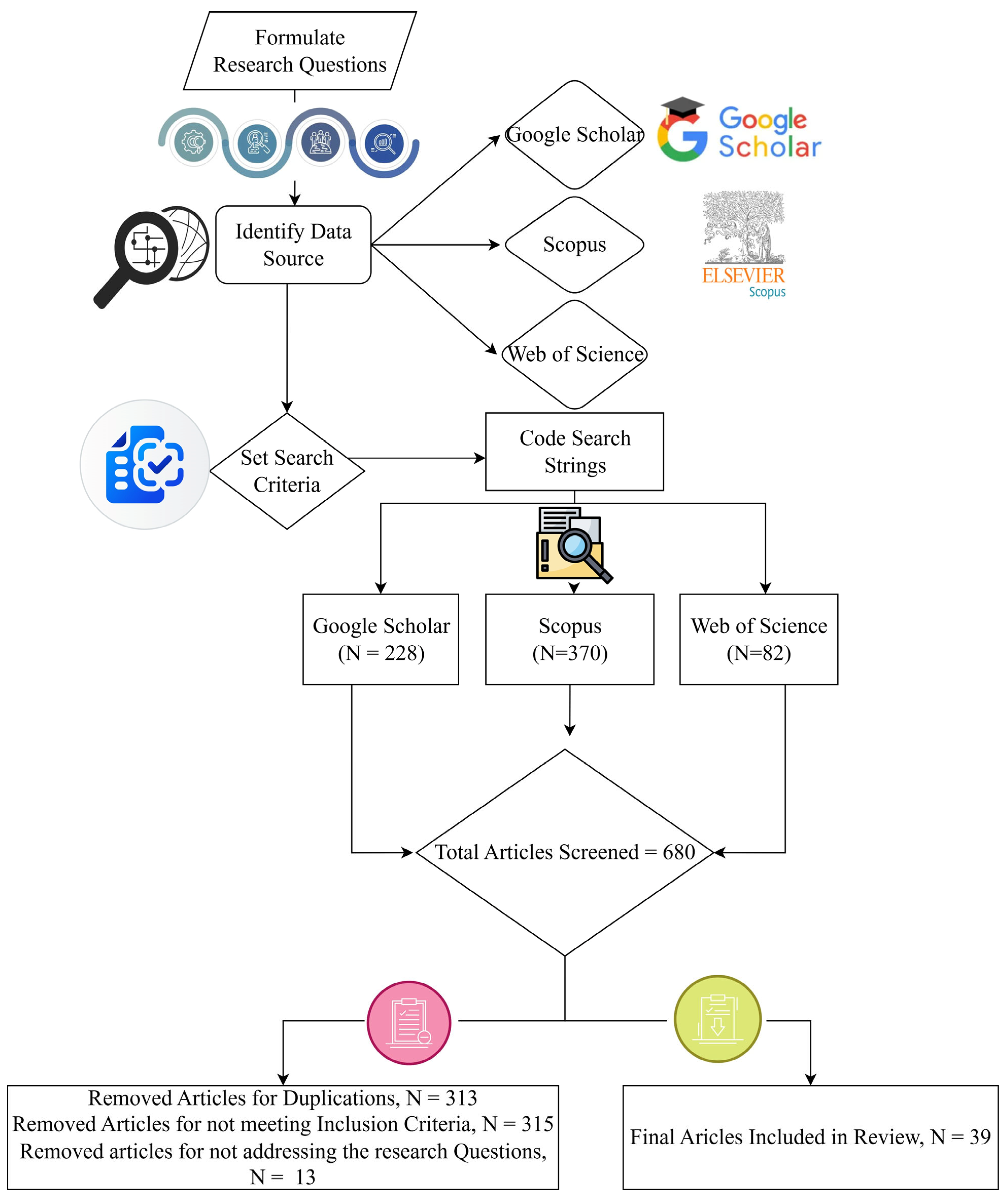
The records were imported to ZOTERO and MS Excel. Two reviewers (Authors 1 and 2) independently screened the titles/abstracts, achieving a κ of 0.84 (95% CI, 0.79–0.89). The full-text screening reached a κ of 0.90. Disagreements were resolved by Author 3, and consensus was reached in 96% of the cases. Figure 2 shows a PRISMA flow diagram.

2.7. Quality Appraisal Tools

2.7.1. Peer-Reviewed Literature

We used the Mixed Methods Appraisal Tool (MMAT, v. 2018), which comprises five core criteria: clarity of research questions, adequacy of data, appropriateness of the method, interpretation, and contextualization. Studies were rated as “high,” “moderate,” “low,” or “excluded.” Only moderate- and high-quality studies were included in the meta-analysis.

2.7.2. Grey Literature

We adapted the Authority, Accuracy, Coverage, Objectivity, and Date (AACOD) checklist [51] to create a 5-point rubric. Two reviewers scored each document, and the inter-rater reliability (ICC = 0.88) was excellent. Documents with a score < 3/5 were excluded.

2.8. Data Extraction Framework

Using a piloted Google Forms sheet, we extracted 42 variables that were grouped into four domains:
-
Descriptors (author, year, document type, funding).
-
Governance actors (CDA, MCI, federal ministries, judiciary, military, private developers, and community organizations).
-
Policy instruments (master plan, zoning regulation, building by-laws, land titling programs, eviction orders, regularization schemes).
-
Spatial outcomes (built-up changes, forest loss, agricultural conversion, heat island intensity, and flood risk).

2.9. Positionality, Trustworthiness, and Reproducibility

Research team composition: Three Pakistan-based urban planners and one GIS specialist. All authors had prior engagement with CDA/MCI projects. Potential bias was mitigated by (a) double coding, (b) an external audit by two independent land use scholars not involved in the study, and (c) reflexive journaling throughout the process. The full search strings (See Table S1. Search Strings and Piloting) protocol (See Table S2. Review Protocols and Guidebook for Screening and Coding the Documents), screening sheets, and extraction templates are provided as Supplementary Material of this manuscript, ensuring maximum transparency for researchers and planning practitioners.

2.10. Ethical Considerations

This study relied solely on publicly accessible documents, and no human subjects were involved. Therefore, ethical approval was not required for this study.

2.11. Review Protocol

Before initiating the content screening process, a protocol guidebook (See Table S2) was developed to ensure the consistency and methodological rigor of the process. The protocol outlined the research questions, eligibility criteria, data extraction processes, and synthesis methods used. The protocols guided the handling of discrepancies and biases in study selection and extraction. Although the review protocol was not registered, as the focus was on synthesizing the existing literature and providing insights into urban planning, all steps were clearly defined and adhered to throughout the process.
The selected content was reviewed in-depth, with particular attention paid to how it addressed the research question, incorporating references to issues such as institutional design, spatial inequality, planning evolution, and sustainability. Throughout the review process, the mind map (Figure 3) was updated iteratively to reflect emerging insights, evolving research directions, and crosscutting themes. This iterative refinement ensured conceptual clarity and methodological consistency of the study. Figure 3 presents the final version of the mind map, illustrating the structured process from search term identification and database selection to screening, data extraction, and thematic synthesis (See Table S5. Research Questions, Codes, Themes and the exemplary excerpt). This approach ensures that the review meets the standards of transparency, reproducibility, and academic rigor, thereby offering a solid foundation for evidence-based insights into Islamabad’s past, present, and future urban development trajectories.

3. Results

The analysis of the extracted data reveals that, while there is some scholarly attention to urban governance and development challenges in Islamabad, the level of study and research on urban planning and design remains insufficient. The dataset comprises 39 scholarly articles published primarily between 2020 and 2025, reflecting the growing academic interest in Islamabad’s urban issues in recent years. However, compared with the scale and complexity of urbanization challenges in cities, the overall volume of research remains limited. Given the rapid expansion of and increasing pressure on cities, in-depth research on urban planning and design is necessary.
These articles appear in 21 different scholarly journals, highlighting the diversity of platforms that contribute to Islamabad’s urban planning discourse. However, despite this variety, representation remains limited. This reflects a gap in the breadth of academic inquiry in this critical field. The limited number of journals also suggests that many urban planning issues in Islamabad have not been fully addressed or studied from any perspective. Among these journals, Sustainability (Switzerland), GeoJournal (Springer), and Cities (Elsevier) stand out as the most active, publishing 17 articles covering approximately 43.5% of the total research. This indicates a strong alignment between the urban development challenges of Islamabad and concerns about global sustainability. However, this focus on sustainability may overlook more localized and specific urban planning challenges that require tailored, context-specific solutions for Islamabad’s complex urban landscapes.
A noticeable increase in publications occurred in 2021, with 13 articles likely reflecting the growing academic interest in Islamabad’s urban development following the introduction of the Islamabad 2020–2040 Master Plan. While this surge suggests heightened awareness and a potential shift towards more comprehensive urban development strategies, it also indicates that such attention is recent and not sustained over the long term. This may be because of the relatively recent implementation of the Master Plan, which may have prompted academic inquiries into its potential outcomes and challenges. However, subsequent publications (2022–2024) show only a moderate continuation of this research interest, revealing a lack of consistent and long-term scholarly engagement with Islamabad’s urban planning. The limited research output in the years following the peak suggests that the academic community does not consistently address the evolving challenges of urbanization in the city, thus failing to offer comprehensive and long-term solutions to these problems.
Thematically, the articles in the dataset address major issues, including governance structures and institutional challenges, spatial concerns such as unplanned urban sprawl, and the socioeconomic impacts of informal settlements. Most articles acknowledge these as critical problems, but only a few have thoroughly explored the multifaceted nature of these urban issues and their long-term implications for Islamabad’s growth. These studies primarily focused on governance inefficiencies, policy inconsistencies, and administrative complexities; however, the analyses remain limited in addressing the full extent of these challenges. While governance issues are frequently mentioned, literature does not delve deeply into the specific ways in which Islamabad’s governance structures contribute to urbanization. Furthermore, the relationship between the fragmented political structures and inefficient urban management remains unclear.

3.1. Cluster Analysis via VOSViewer Network Visualization

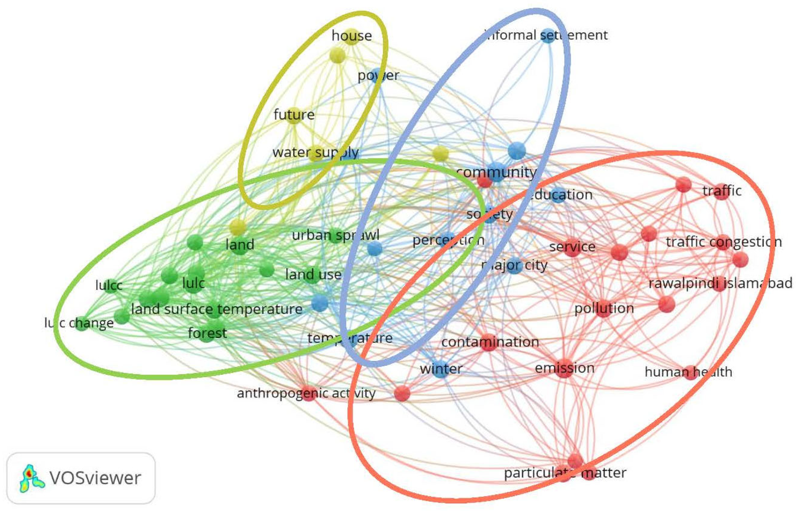
Network visualization (Figure 4), generated using VOSviewer, version 1.6.20, provides a detailed and insightful representation of the relationships between key terms associated with urban development, environmental factors, societal issues, and infrastructure challenges [52]. This visual network analysis offers a clearer understanding of how researchers have explored Islamabad’s urbanization and its associated impacts. This analysis highlights the critical dynamics that shape Islamabad’s urban environment and growth trajectory, particularly as the city navigates through the pressures of development, environmental preservation, and social equity. This image serves as a tool for visualizing how various concepts, including urbanization, pollution, community health, and infrastructure, have been studied. By examining these relationships, we can gain a deeper understanding of how urban development affects a city’s environmental and social fabric. These dynamics are particularly relevant as the city faces challenges, such as rapid urban sprawl, politically driven policymaking, power politics, infrastructure overload, and environmental degradation, all of which are reflected in the visualization.
The visualization was organized into four distinct clusters, each representing a unique and interconnected theme. Each node in the network corresponds to a specific term, such as “land use,” “water resources,” “socio-economic disparity,” “urban sprawl,” and “public health.” The edges between nodes indicate the strength and nature of the relationships, shedding light on how one concept influences the other. For example, terms such as “urban sprawl” and “land use” are likely to have strong connections, indicating that urban growth patterns significantly affect land allocation and environmental conditions. Similarly, the link between “pollution” and “community health” underscores the direct impact of environmental degradation on the well-being of residents, which is a grave concern in rapidly urbanizing cities such as Islamabad.
Furthermore, the relationships between these clusters revealed a web of interconnected challenges. For instance, the expansion of urban sprawl in Islamabad not only increases the pressure on land resources [19], but also elevates pollution levels, which in turn impacts public health [53]. These feedback loops, in which one issue exacerbates the other, are essential for developing sustainable, long-term urban planning solutions. This network visualization via the VOS viewer provides a valuable tool for understanding the complexities of urban development, particularly in rapidly growing cities, such as Islamabad. By visualizing the interactions between environmental, societal, and infrastructural factors, it becomes clear that addressing one issue, such as land use, pollution, or social inequality, requires an integrated approach that considers a broader urban ecosystem. Sustainable urban planning in Islamabad must strike a delicate balance between promoting growth and ensuring that the city remains environmentally resilient, socially equitable, and infrastructural for future generations.
The green cluster in the visualization provides a comprehensive view of the relationship between land use and environmental factors as well as concepts that are particularly relevant to urban planning in Islamabad, Pakistan. This cluster, which encompasses terms such as “land use,” “urban sprawl,” “aquifer,” “forest,” and “barren land,” reflects the ongoing transformation of the city’s landscape as it expands, along with the environmental consequences of these transformations. In the case of Islamabad, a city designed with a vision for long-term sustainability, these factors highlight both the success and challenges of Islamabad’s urban planning strategy, which have been studied previously. A significant aspect of Islamabad’s development is “land use.” Islamabad’s original urban design, developed in the late 1950s by Constantinos A. Doxiadis, carefully planned different zones for residential, commercial, and recreational activities [17,24,28], aiming to strike a balance between urban development and preservation of the natural environment [8,53]. However, over the decades, cities have experienced changes in land use, as urban expansion continues [29,39]. As more residential and commercial spaces have been developed to accommodate the city’s growing population, agricultural and green lands on the outskirts of Islamabad have been repurposed for real-estate development [20,23,30,31,53]. This shift has had significant implications for the surrounding environment, as natural ecosystems have been disrupted and valuable resources such as water and soil quality have been affected.
Urban sprawl is one of the most pressing environmental issues resulting from urban expansion in Islamabad [19]. The rapid growth of the city has led to the extension of its boundaries, encroaching on once-rural areas and causing urban landscapes to sprawl into previously undeveloped regions [12,20,22,30]. This expansion consumes valuable land and poses an environmental challenge. For example, urban sprawl in Islamabad has increased pressure on the city’s infrastructure [54], with insufficient resources dedicated to mitigating the environmental impact of this rapid development. This has also led to a loss of forests, agricultural land, and wetlands [8,29,39], further exacerbating the environmental pressure facing the city.
A particularly relevant term in the context of Islamabad is the “aquifer.” Islamabad’s location near Margalla Hills is a key environmental asset; however, as the city grows, the demand for water resources increases [21,32,55]. The city depends heavily on underground water sources, particularly aquifers, to meet increasing water demand. [32]. However, the rapid pace of urbanization combined with poor land management practices has led to the overextraction of groundwater, raising concerns about the depletion of these vital resources in the region. [32]. In recent years, unsustainable groundwater extraction, primarily driven by the expansion of residential areas, has placed pressure on the aquifers that supply the city. Overextraction can reduce water quality and availability [56], which increasingly affects a city’s long-term sustainability, particularly because climate change further exacerbates water scarcity in the region [33].
Terms such as “forest,” “barren land,” “climate,” “temperature,” and “land cover” are closely linked to environmental issues arising from urban planning in Islamabad. [33,53]. Islamabad, originally designed to integrate nature into urban life [14,53], has experienced a decline in green space due to urban sprawl. Forested areas on the outskirts, particularly around Margalla Hills National Park, have been encroached upon, diminishing the natural resources of the city [20]. The loss of forested areas, coupled with an increase in impervious surfaces such as roads and buildings, contributes to habitat destruction, reduced carbon sequestration, and heightened vulnerability to climate change. The term “land cover” is also crucial for understanding climate-related changes in Islamabad, Pakistan. The conversion of natural land cover, such as forests and agricultural land, into urban development has led to significant changes in the ecological balance of cities [8,29,31,34,39]. These land cover changes increase the risk of flooding owing to reduced water absorption. [53], reduces the city’s capacity to regulate temperature [39], and decreases overall environmental resilience [53]. The loss of natural land cover is particularly concerning in Islamabad, where the natural landscape has historically played a crucial role in maintaining the ecological balance, regulating water flow, and improving air quality. While the original urban plan aimed to create a city that would be sustainable in the long term, the pressures of rapid urbanization [17], urban sprawl [19], and increased demand for water resources [21,33] have strained the natural environment of the city.
The relationship between “community” and “pollution,” “traffic,” and “water supply” in the red cluster indicates that issues such as access to clean air, water, and essential services are crucial to the well-being of Islamabad’s urban population. Furthermore, the strong connections between “land use” and “climate” demonstrate how urbanization contributes to environmental changes. The spread of urban areas often leads to the destruction of forests and other natural landscapes [20,29], exacerbating climate change and disrupting local ecosystems [35,53,54]. This creates a feedback loop in which the impacts of urbanization worsen environmental conditions, further affecting communities, particularly in vulnerable areas, such as informal settlements [26,40,54].

3.2. Governance, Inequality, and Politics in Islamabad’s Urban Development

Islamabad, Pakistan’s capital, was officially designated as the country’s capital in 1960 [12,14,17,22]. The decision to establish Islamabad as the seat of the government was not merely pragmatic; it was a visionary attempt to create a symbol of national unity in a nation that was deeply divided both ethnically and geographically. [12,14,18,22,36,37,43]. At the time of its selection, Pakistan had a heterogeneous population comprising various ethnic groups and regional identities [18]. The relocation of the capital from Karachi to Islamabad was intended to foster a sense of national cohesion by providing a neutral ground that could represent the unity of Pakistan [12,17,44,45,46]. Islamabad was envisioned as a flag-bearer of modernity, symbolizing a forward-looking and progressive future for the country [14,43]. Its design and infrastructure reflect the aspirations of a newly independent nation striving to assert itself globally. The city is also intended to serve as a central hub for government activities, housing the main administrative offices and residences of the nation’s key political leaders [14,17,38,43].
The establishment of the city was formalized through the Capital Development Authority (CDA) Ordinance of 1960, which legally constituted the CDA [14]. The CDA was tasked with overseeing the management, planning, and development of Islamabad, ensuring that the city was designed to accommodate the country’s growing administrative and political functions of the country [12,14,19,35,43]. Under the provisions of the CDA Ordinance 1960 and the Pakistan Capital Regulation (MLR) 1982, the CDA was granted significant autonomy to guide the development of Islamabad according to a specific urban vision that aligned with the broader goals of modernization and national integration [14]. The CDA mandate, as outlined in the ordinance, provided the authority to acquire land, design master plans, and regulate urban growth [14,17,23,28,43].
In 1992, as the city continued to grow and evolve, the CDA introduced the Zoning Regulation of 1992 [14,23,28,43]. This regulation played a critical role in shaping the spatial organization of the city, dividing Islamabad into five distinct zones, each with its own designated function and development guidelines [17,38,43,57]. Zone 1, considered the central and most critical area, was designated for development by the CDA, ensuring that central administration and political functions were concentrated in this region [14]. This was viewed as a means of maintaining control over the core areas of the city, ensuring that it could continue to serve its purpose as the epicenter of national governance. Zones 2 and 5, on the other hand, were allocated for private development, specifically housing societies [43]. These zones allow private developers to undertake residential projects, thereby contributing to the expansion of Islamabad’s urban landscape. However, this also introduced the challenge of ensuring that the rapid growth of private housing does not overwhelm the city’s infrastructure or undermine the planned nature of the city. Zone 3 was designated as a reserved area intended to preserve natural landscapes and prevent overdevelopment in this part of the city [43]. This area has remained largely undeveloped to protect the natural environment, contributing to Islamabad’s identity as a green city, known for its natural beauty and scenic views. Zone 4 has a multifaceted role, with land earmarked for a range of activities, including national parks, agro-farming areas, educational institutions, and R&D facilities [14,17,43]. This zone reflects the broader vision of Islamabad, not just as political capital but also as a center of knowledge, innovation, and sustainable development. It was intended to balance urbanization with the preservation of green spaces and to promote research and educational activities that could drive Pakistan’s economic and social development.
Islamabad faces considerable challenges in urban planning, many of which stem from its governance structures and institutional decisions [22,23,24,36,43]. The rapid growth and urbanization of cities have created immense pressure on infrastructure, housing, and services [18,19,20]. These issues are compounded by the fragmented nature of governance, which hinders cities’ ability to respond effectively. At the core of these governance issues is the division of authority between key institutions, primarily the Capital Development Authority (CDA) and Metropolitan Corporation Islamabad (MCI), [17,18,36]. Historically, the CDA has been responsible for overseeing Islamabad development. However, the establishment of the MCI under the Islamabad Capital Territory Local Government Act of 2015 was intended to decentralize governance and provide greater local control. Unfortunately, rather than fostering a more streamlined decision-making process, this move has led to dual governance [28,40]. The CDA continues to dominate urban planning decisions, while the MCI, although given responsibility for local services, has become financially dependent on the federal government and CDA [43]. This has resulted in a lack of autonomy, limiting MCI’s ability to enact independent urban policies [40].
The inability to resolve the fragmented governance structure has contributed to a host of urban planning issues, including the proliferation of informal settlements and urban sprawl [12,19,24]. In a city like Islamabad, where land management is a key challenge, the lack of coordinated governance has led to ineffective land use planning and regulations. Urban expansion has largely occurred without adherence to formal zoning laws [23] and critical natural spaces, including agricultural and forested land, have been converted into built-up areas [29]. The failure of governance to prevent sprawl has exacerbated the city’s environmental problems such as the loss of green spaces, increased pollution, and decreased biodiversity. Furthermore, informal settlements have emerged in ecologically sensitive areas, often lacking adequate infrastructure, waste management, or access to essential services [23,25,26,58].
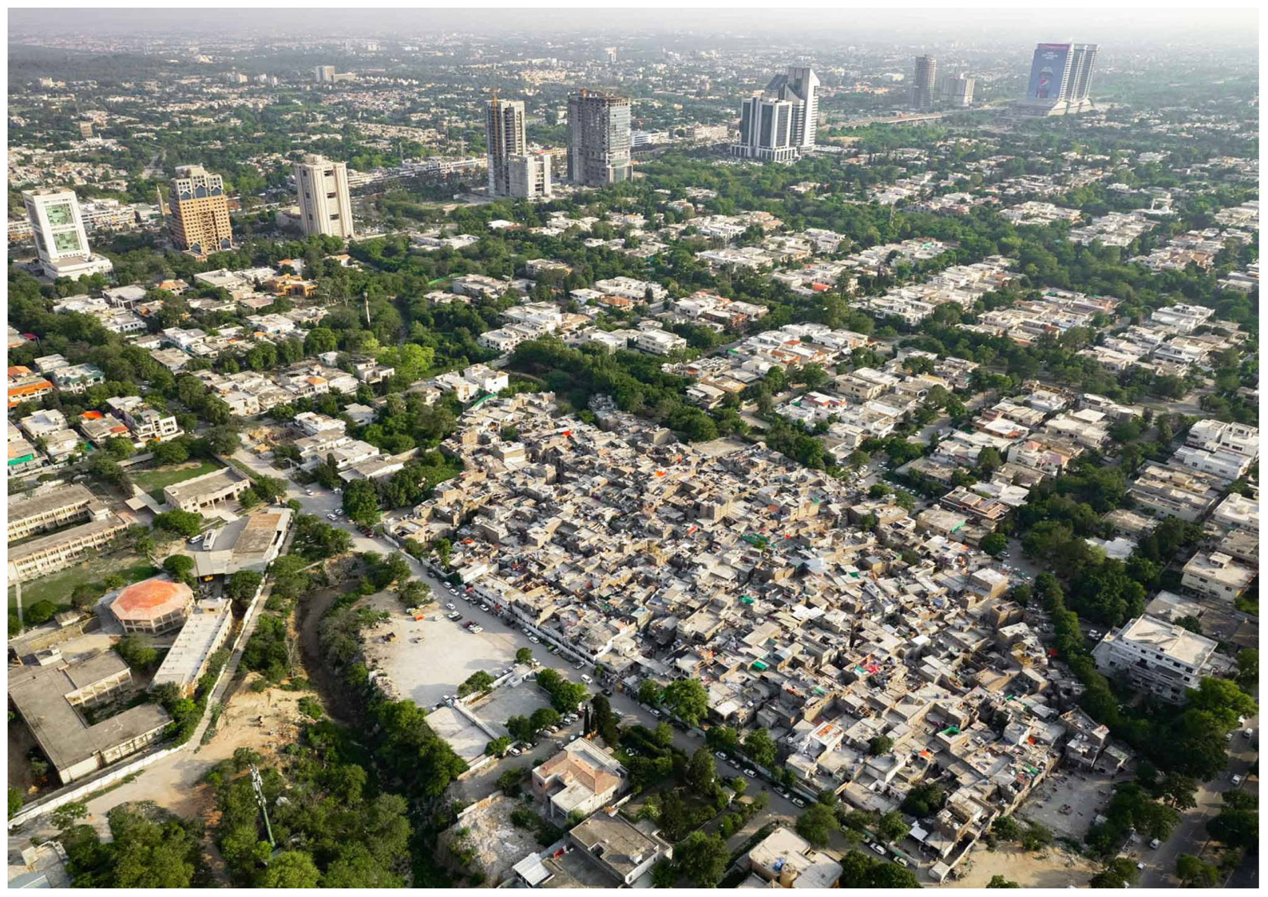
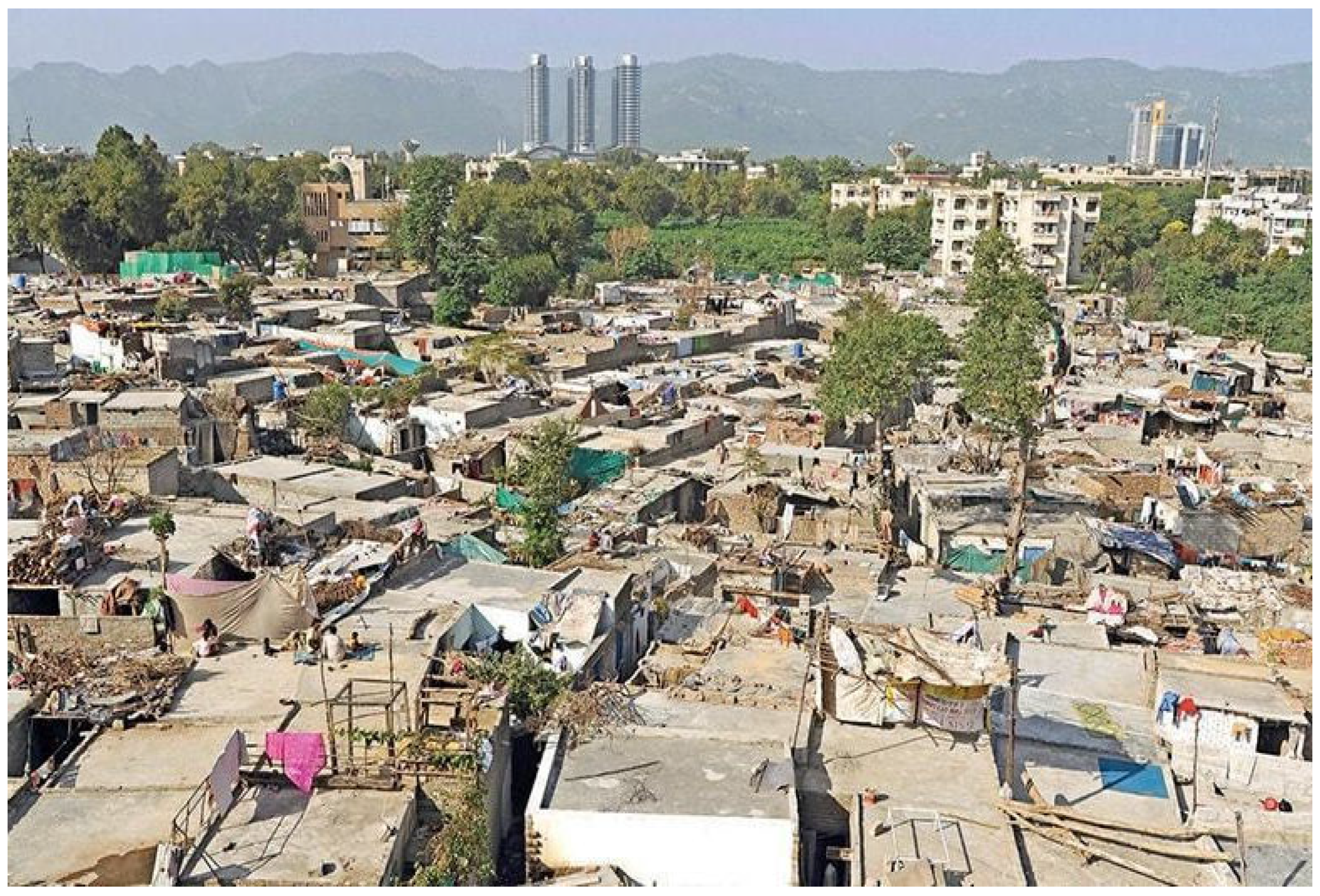
Another issue related to governance structures is the exclusion of informal settlements from the formal urban framework [17,22,59]. These informal areas, which often lack legal recognition and property rights, are marginalized in urban planning [12,22,24]. In neighborhoods like the France Colony (see Figure 5 and Figure 6), residents are left to fend for themselves in terms of accessing services such as clean water, sanitation, and healthcare [60]. Despite the increasing number of informal settlements, the government has been slow to formalize these areas or integrate them into the broader urban system [12,25,38]. The failure to address the growing need for affordable housing and basic infrastructure in informal areas has contributed to inequality, poverty, and social exclusion in the country. Informal communities are often stigmatized, and their contributions to the city’s economy, such as informal labor and local trade, are neither acknowledged nor supported by urban policies. The summary of the articles that explored all these issues is presented in Table 1.

3.3. Spatial, Social, and Economic Impacts of Unplanned Growth in Islamabad

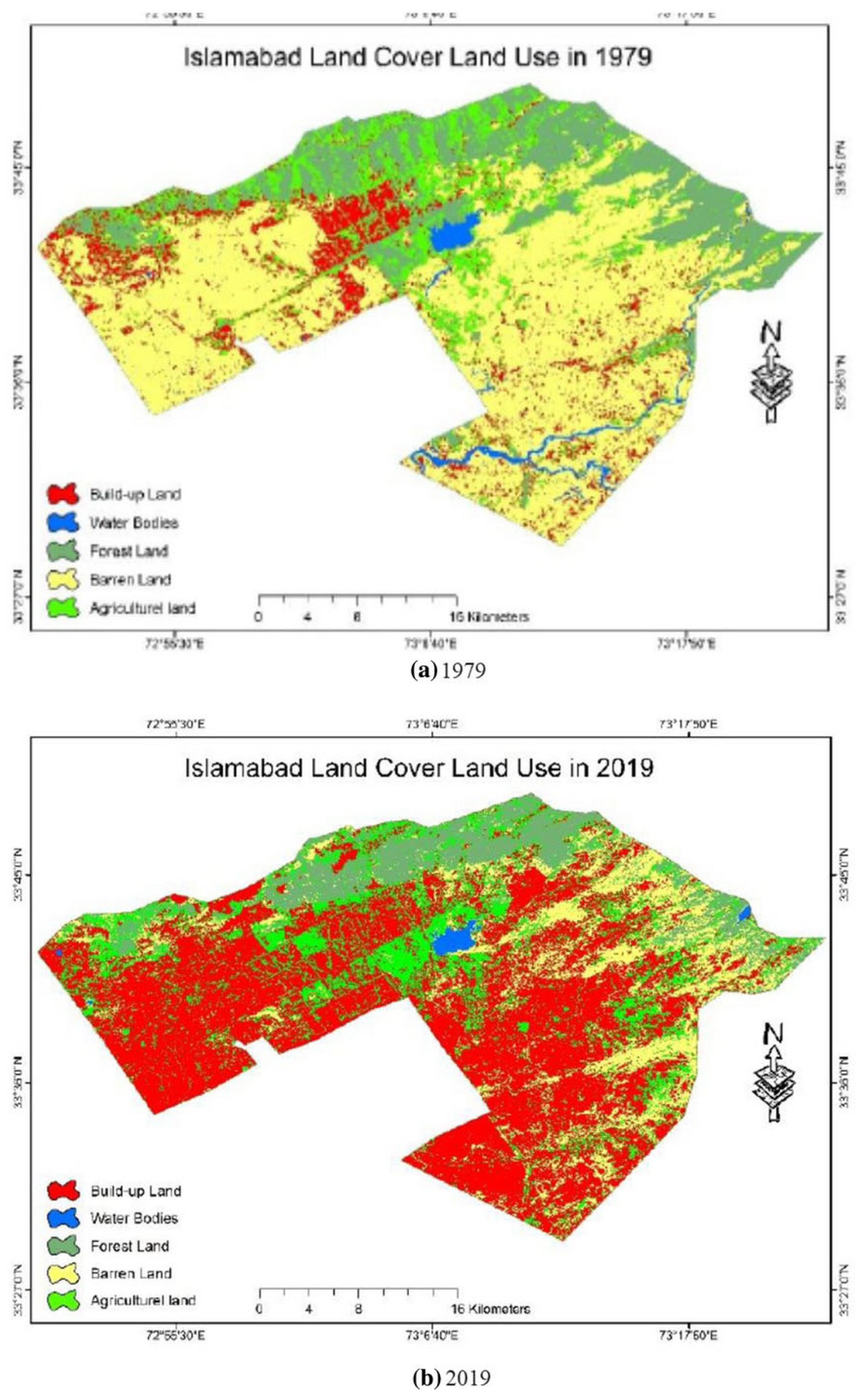
A review of peer-reviewed studies addressing the spatial patterns of unplanned growth and informal settlements in Islamabad revealed converging concerns about unsustainable urban expansion and marginalization of vulnerable populations. These studies, which employ both satellite image analysis and social surveys, collectively show how spatial transformations have reshaped a city’s ecological and socioeconomic landscapes. Remote sensing-based studies [29,39] have shown a consistent and extraordinary increase in built-up areas of Islamabad. Using a novel object-based backdating method, Liu et al. [30] reported a 426% increase in the urban land area between 1990 and 2018, with impervious surface cover increasing by more than 273% during the same period. Similarly, Shah et al. [19] detailed an expansion (see Figure 7) of 377 km2 of built-up land from 1979 to 2019, accompanied by significant losses in forest cover (83 km2) and barren land (333 km2). These land cover transitions not only signal rapid urbanization but also indicate long-term ecological degradation. Aslam et al. [35] and Mannan et al. [20] highlighted the impact of such an expansion on the local climate, including increased land surface temperatures and reduced carbon storage capacity in forested areas, where the estimated carbon stock declined to 139.17 Mg C/ha. Several studies have linked land use changes to declining sustainability across the environmental, economic, and social dimensions. Aziz and Anwar. [64] reported that urban growth disrupted urban green infrastructure and raised land surface temperatures, placing both environmental and economic sustainability at risk. [8]. While spatial data establishes the magnitude of urban growth, cross-sectional surveys reveal human consequences, particularly for residents of informal settlements.
Khan et al. [58] reported a substantial increase in impervious surfaces (11.9%) at the expense of green and agricultural land, suggesting a decline in environmental resilience that disproportionately affects marginalized communities. Health vulnerabilities associated with poor land use planning were made explicit by Akmal and Jamil [65], who found that households located within 100 m of open waste disposal sites experienced significantly higher rates of malaria, dengue, and asthma. Zia et al. [66] further reinforced the city’s waste governance challenges; daily solid waste generation was reported at 0.6 kg per capita, with little differentiation in waste management services across socioeconomic strata (SES). Spatial inequity is also evident in the housing markets. Hussain et al. [26] concluded that proximity to slum areas negatively affected rental values, reinforcing the spatial stigmatization of informal settlements. Their findings show that property rents increase as the distance from slums increases, reflecting deeply entrenched perceptions of slums as urban disamenities rather than as communities that need to be integrated.
Collectively, these studies paint a picture of a city expanding rapidly but unevenly, where land use changes driven by unregulated urban growth intersect with governance shortcomings to produce spatial and social inequity. Although quantitative satellite-based studies effectively chart environmental degradation, they often lack critical engagement with institutional and political drivers of land transformation. Conversely, social science–oriented studies, although fewer in number, underscore the lived consequences of these spatial changes, especially in informal settlements that remain underserved and are excluded from mainstream urban planning. A summary of the articles reporting the spatial, social, and economic impacts of unplanned growth in Islamabad is provided in Table 2.

3.4. The Urban Development Strategies and Challenges Associated with Islamabad

A diverse body of peer-reviewed research has examined Islamabad’s urban development strategies and challenges through the lens of sustainability, resilience, infrastructure, governance, and integration of informal settlements. The studies covered in this synthesis reflect a growing recognition that urban sustainability in Islamabad is shaped not only by physical infrastructure and environmental systems, but also by community behavior, cultural practices, and institutional frameworks. Several studies have investigated the social and behavioral dimensions of sustainable urban communities (SUCs). Hasnain [63] highlighted how routine disruptions in electricity, water, and gas supplies significantly affect food security, mobility, and everyday life in Islamabad’s middle class, underscoring the need for integrated urban service planning. Rehman et al. [68] similarly underscored the role of public behavior and environmental awareness in shaping sustainable futures, reporting that individual conservation practices regarding water, energy, and recycling have a strong influence on overall urban sustainability outcomes. Shahid et al. [54] introduced a Social Capital Index to quantify community cohesion across formal and informal settlements, revealing that informal settlements often have stronger internal trust and support networks, despite limited access to institutional resources. This distinction contributes to our understanding of social capital as the foundation of urban resilience in several ways.
Khan et al. [23] further explored the resilience of marginalized Islamabad populations by emphasizing how geographic scale, resource limitations, and financial constraints significantly affected the sustainability of residents of informal settlements in Islamabad. Khan et al. [58] assessed data-driven urban management and revealed that privacy and security concerns could partially mediate the effectiveness of digital governance systems intended to upgrade slums. These findings highlight the tension between technological innovation and community trust, and underscore the need for digital solutions to be paired with social safeguards to achieve inclusive development.
Infrastructure-specific studies have focused on resource efficiency and the environmental impacts of urban systems. Jameil [55] evaluated the energy demands of urban water and found that water distribution alone accounts for up to 98% of total energy consumption, raising concerns about the sustainability of Islamabad’s water infrastructure. Maqsoom et al. [21] presented a rainwater harvesting assessment model using Building Information Modeling (BIM), estimating collection potentials ranging from 8190 to 103,300 L annually, depending on site selection. These technical assessments provide valuable evidence for designing more resilient water-supply strategies in the face of increasing demand and climate variability in the future. A complementary line of inquiry explored cultural heritage and placemaking in informal settlements, providing critical insights into grassroots resilience. Shafqat et al. [60] and Shafqat et al. [69] examined informal settlements as repositories of rural culture and argued that the organic placemaking practices of rural migrants foster socially cohesive and adaptable communities. Naqvi [70] added a political dimension to this discourse, showing how residents of katchi abadis strategically adopt the language of neoliberal property rights in pursuit of formal recognition by the state. Together, these studies complicate the dominant narratives that frame informal settlements as urban liabilities, revealing these communities as sites for negotiation, adaptation, and cultural sustainability.
Environmental monitoring remains a key focus in urban development research. Ali et al. [67] utilized satellite-derived land surface temperature (LST) data to document rising temperature trends, thereby contributing to concerns regarding urban heat island effects. Similarly, Basharat et al. [32] conducted a geospatial analysis of groundwater quality and quantity, identifying sectoral variations and elevated electrical conductivity in areas, such as G-8 and G-11. These findings reinforce the earlier concerns regarding hydrological stress and water insecurity, particularly in densely populated areas. Collectively, these studies highlight the multiscale and interdisciplinary nature of the urban sustainability challenges in Islamabad. Although infrastructure and environmental systems remain critical areas of focus, questions regarding governance, community resilience, and social inclusion are equally important. The literature emphasizes that sustainable urban development in Islamabad cannot rely solely on technocratic fixes; it must also incorporate community agencies, cultural knowledge, and equitable policy frameworks to address the city’s long-standing structural and environmental vulnerabilities. A summary of articles addressing urban development strategies and challenges in Islamabad is presented in Table 3.

4. Discussion

The concept of planned cities has long been a subject of intense debate in urban studies, particularly regarding their ability to adapt to the evolving needs of their populations. A prominent example of a planned city is Islamabad, Pakistan’s capital, which was designed by Greek architect Constantinos A. Doxiadis in the late 1950s as a model city for the future, based on his theory of ekistics [17,18,22,37]. Islamabad’s design, conceived with foresight and an emphasis on functionality, sought to harmonize human, social, and physical needs through a carefully structured urban plan. Although Islamabad initially thrived under this master-planned framework, the challenges posed by urban growth, shifting societal demands, and evolving environmental concerns highlight the limitations of rigid planning in contemporary urban settings.
The collective corpus of peer-reviewed research addressing Islamabad’s urbanization reveals a diverse, yet fragmented academic landscape, wherein spatial diagnostics, governance critiques, and development strategies have been examined in relative isolation. When analyzed together, the studies summarized in Table 1, Table 2 and Table 3 provide a multilayered understanding of the ongoing urban transformation of cities. However, there are significant intellectual gaps in this synthesis. Although scholars have advanced our empirical knowledge of land cover change, informal settlements, infrastructure vulnerabilities, and institutional failures, their analyses often remain confined to specific disciplines. This has led to rich documentation of outcomes but comparatively shallow interrogation of the political, institutional, and historical processes that drive them.
The first significant cluster of studies (Table 1) predominantly focuses on the spatial and environmental manifestations of unregulated urban growth. Through satellite image surveys and remote sensing methodologies, studies by Liu et al. [30], Shah et al. [19], and Mannan et al. [20] offered quantitative evidence of land use and land cover (LULC) transformations, such as the expansion of impervious surfaces, deforestation, reduction in vegetative cover, and a significant rise in land surface temperatures. These environmental indicators reflect the intensifying ecological crisis in Islamabad over the past three decades. For instance, Liu et al. [30] reported a staggering 426% increase in urban land, whereas Mannan et al. [20] quantified a decline in forest carbon stocks, indicating a deteriorating local climate. However, despite their methodological sophistication, these studies often suffer from ecological reductionism, in which urban growth is conceptualized in biophysical terms without interrogating the political economy of land use. In many cases, land transformation is portrayed as an inevitable byproduct of demographic expansion or natural urban evolution rather than a consequence of deliberate governance choices, speculative real estate practices, and elite interests. For example, Bokhari et al. [8] highlighted the dramatic increase in built-up areas in Pakistan. However, they did not explore the role of regulatory loopholes or state-private sector partnerships in shaping these changes. Similarly, while aquifer depletion and flood risk are well documented [32,53], institutional accountability for the use of illegal borewells, issuance of land conversion permits, and absence of zoning enforcement remain conspicuously lacking.
The second body of research, presented in Table 3, focuses on urban development strategies and technological interventions that aim to mitigate the consequences of unplanned growth. These include studies evaluating rainwater harvesting [21], life cycle assessments of water treatment infrastructure [55], and the potential of data-driven decision-making for urban upgrading [23]. There are also valuable contributions to social capital, community resilience, and citizen behavior in sustainability transitions [54,68]. These studies are notable for incorporating human agency and technical solutions into sustainability discourse. However, a recurring limitation is their technocratic framing, where urban resilience is often reduced to behavioral change or engineering fixes, decoupled from structural determinants, such as inequality, displacement, or entrenched power dynamics. For example, while Khan et al. [23] highlighted resilience challenges in slum communities, their proposed solutions largely focused on resource allocation, without addressing historical exclusion or legalized marginalization.
In contrast, Table 1 provides a much-needed corrective by foregrounding the politics of urban spaces. This cluster of studies examines governance structures, legal instruments, and ideological frameworks that have historically influenced the spatial order of Islamabad. Scholars such as Moatasim [12,22,24], Waheed [62], and Akhtar and Rashid [36] have revealed that planning decisions in cities consistently favor elite groups, often at the expense of low-income and informal residents. Moatasim [12,22,24] examined Bani Gala and illustrated how influential residents successfully lobbied for zoning changes, resulting in structural shifts in the planning regime of Islamabad. Similarly, Waheed [62] shows how official narratives criminalize informal settlements, framing them as threats to the urban order rather than products of exclusionary planning. These studies have deepened our understanding of how spatial inequality is legally produced, discursively justified, and politically maintained.
However, a disconnect remains, while environmental and technological studies chart the degradation of natural systems, and governance-focused research outlines the structures that enable these patterns; these bodies of work rarely intersect. Consequently, the relationship between ecological outcomes and political intent is often under-theorized. For instance, extensive literature on heat islands, flooding, and air pollution [19,39] rarely acknowledges the unequal distribution of these risks across different social groups. As highlighted by Ahmed [46] and Akmal and Jamil [65], informal settlements face three burdens: environmental exposure, infrastructure neglect, and policy invisibility. However, these vulnerabilities are seldom understood as outcomes of systemic neglect rooted in the institutional history of the Islamabad Master Plan [28], land regularization politics, and militarized urban development practices [36].
Another notable shortcoming of the reviewed literature is the lack of cross-sectional and longitudinal analyses. Most studies, whether spatial, technological, or political, rely on cross-sectional data, limiting their ability to track the evolution of environmental burden, displacement, or exclusion. Moreover, demographic lenses, particularly those of gender, ethnicity, and class, are weakly developed, which flattens the lived experiences of urban inequality into generalized statistical categories. The dominant emphasis on satellite data in environmental studies, while valuable, has inadvertently contributed to the depersonalization of the urban poor, reducing communities to mere pixels and trends, rather than recognizing them as political actors with agency, history, and knowledge.
Methodologically, this reflects the broader epistemological divide in Islamabad. While environmental sciences often prioritize remote sensing and spatial modeling, critical urban studies emphasize discourse analysis, participatory research, and institutional ethnography. These paradigms rarely intersect or communicate with one another. This has led to a research ecosystem in which the causes and consequences of urban change are studied in parallel, rather than through dialogue. For instance, while Shahid et al. [54] highlighted the strength of social capital in informal settlements, planning-oriented studies have not utilized such insights to imagine co-produced solutions for the future. Similarly, findings on carbon sequestration or aquifer decline are rarely linked to land governance practices or concerns regarding political economies.
In synthesizing the literature, it becomes clear that Islamabad’s urban crisis is not just a technical failure or ecological emergency; it is a political project shaped by legal exclusion, elite negotiations, market logic, and bureaucratic inertia. The real estate sector’s influence on zoning, inconsistent revision of master plans, and institutional criminalization of informal communities all point to a more profound structural logic underpinning unsustainable development. Therefore, addressing this crisis requires more than just better models and green technology. This demands a normative shift in how research engages with urban politics from documenting problems to interrogating the systems that produce them to address the issue. Future research must adopt interdisciplinary, justice-oriented frameworks that center on marginalized voices, question power asymmetries, and integrate spatial diagnostics and institutional analyses. Participatory mapping, ethnographic engagement, and historical tracing of land policies can enrich remote sensing outputs, whereas governance critiques can be strengthened by embedding them within spatial and environmental evidence. Until then, urban research in Islamabad continued to operate in silos, capturing degradation without confronting the systems of privilege, governance, or dispossession that sustain it.

5. Conclusions

This study explored the limitations of a rigid planning model using Islamabad as a key case study. This paper presents a case of integrating adaptability and organic growth into the urban planning process. Although research on the urban development of Islamabad has emerged over the past decade, it remains conceptually fragmented. Published peer-reviewed research is dominated by satellite-based assessments that map land use changes, heat island effects, groundwater stress, and biophysical indicators. These studies have powerfully documented ecological decline but have tended to treat urban growth as an apolitical by-product of population pressure rather than an outcome of land speculation, elite zoning privileges, and uneven state enforcement. A second stream, rooted in engineering and sustainability science, proposed technical fixes, rainwater harvesting, energy-efficient water treatment, and data-driven slum upgrading, but rarely addressed institutional or distributive obstacles that block implementation. More recent contributions in critical planning, history, and urban politics have begun to fill this gap by revealing how Islamabad’s master plan revisions, real estate financialization, and militarized governance have produced systematic dispossession, spatial segregation, and the criminalization of informal settlements. Taken together, the literature demonstrates that resilience, climate adaptation, and environmental sustainability are frequently acknowledged, but seldom integrated into a holistic framework linking infrastructure investment with social justice, participatory governance, and long-term ecological stewardship. Therefore, future research must move beyond parallel diagnostic silos towards integrative, justice-oriented approaches that place informal settlements, gendered and class inequalities, and political economy at the center of planning debates. Only by coupling robust spatial evidence with institutional reform and community co-production can Islamabad and cities facing similar postcolonial pressures translate sustainability rhetoric into an inclusive, adaptable, and genuinely resilient urban future.

Supplementary Materials

The following supporting information can be downloaded from https://www.mdpi.com/article/10.3390/land14112248/s1, Table S1. Search Strings and Piloting; Table S2. Review Protocols and Guidebook for Screening and Coding the Documents; Table S3. Articles included in the final thematic analysis; Table S4. PRISMA Checklist; Table S5. Research Questions, Codes, Themes and the exemplary excerpt.

Author Contributions

Conceptualization, G.S. and H.H.; methodology, J.A.; validation, N.A. and J.A.; writing—original draft preparation, N.A.; writing—review and editing, G.S. and H.H.; visualization, N.A. and J.A.; supervision, G.S. and H.H. All authors have read and agreed to the published version of the manuscript.

Funding

This research received no external funding.

Data Availability Statement

The data will be made available upon request.

Conflicts of Interest

The authors declare no conflict of interest.

Abbreviations

The following abbreviations are used in this manuscript.
CDACapital Development Authority
MCIMetropolitan Corporation Islamabad
LULCLand Use Land Cover Changes
OSFOpen Science Framework
ICTIslamabad Capital Territory
PRISMAPreferred Reporting Items for Systematic reviews
SUCsSustainable Urban Communities

References

  1. Mkrtchyan, N. Nation-Building Projects through New Capitals: From St. Petersburg to Yerevan and Astana. Natl. Pap. 2017, 45, 485–498. [Google Scholar] [CrossRef]
  2. Lessoff, A.H. Washington Under Federal Rule, 1871–1945. In Berlin–Washington, 1800–2000; Daum, A., Mauch, C., Eds.; Cambridge University Press: Cambridge, UK, 2005; pp. 235–262. ISBN 978-0-521-84117-7. [Google Scholar]
  3. Holston, J. The Modernist City: An Anthropological Critique of Brasília; University of Chicago Press: Chicago, IL, USA, 1989; ISBN 978-0-226-34978-7. [Google Scholar]
  4. Ismail, N.A.; Adu-Ampong, E.A.; Aceska, A. The Making of Urban Informal Settlements: Critical Junctures and Path Dependency in Governing Abuja, Nigeria. Cities 2024, 147, 104789. [Google Scholar] [CrossRef]
  5. Park, J. Between a Beautiful City and a Garden City: Walter Burley Griffin’s Design of Canberra. J. East–Asian Urban Hist. 2020, 2, 297–308. [Google Scholar] [CrossRef]
  6. Syaban, A.S.N.; Appiah–Opoku, S. Unveiling the Complexities of Land Use Transition in Indonesia’s New Capital City IKN Nusantara: A Multidimensional Conflict Analysis. Land 2024, 13, 606. [Google Scholar] [CrossRef]
  7. Putra, A.A.; Makmur, M.; Takdir, R.A.; Wibowo, A.H.; Ladianto, A.J.; Wulandari, N.R.; Nugraha, F.W. Towards A Sustainable City: Strategic Approach to Smart City Development. FCE 2025, 11, 14. [Google Scholar] [CrossRef]
  8. Bokhari, S.A.; Saqib, Z.; Amir, S.; Naseer, S.; Shafiq, M.; Ali, A.; Zaman–ul–Haq, M.; Irshad, A.; Hamam, H. Assessing Land Cover Transformation for Urban Environmental Sustainability through Satellite Sensing. Sustainability 2022, 14, 2810. [Google Scholar] [CrossRef]
  9. Sengupta, U.; Nielsen, K. The Politics of Urban Land in South Asia: Current Challenges and New Directions, 1st ed.; Routledge India: New Delhi, India, 2025; ISBN 978-1-003-53066-4. [Google Scholar]
  10. Chalana, M. Chandigarh: City and Periphery. J. Plan. Hist. 2015, 14, 62–84. [Google Scholar] [CrossRef]
  11. Pambila, G.F.; Kazaura, W.G.; Magina, F.B. Is It a Local Community-Centered Plan? Community Participation in the Dodoma Master Planning and Implementation Processes. GeoScape 2025, 19, 42–63. [Google Scholar] [CrossRef]
  12. Moatasim, F. Master Plans and Encroachments: The Architecture of Informality in Islamabad; University of Pennsylvania Press: Philadelphia, PA, USA, 2023; ISBN 978-1-5128-2519-0. [Google Scholar]
  13. Guedes, R.; Iachan, F.S.; Sant’Anna, M. Housing Supply in the Presence of Informality. Reg. Sci. Urban Econ. 2023, 99, 103875. [Google Scholar] [CrossRef]
  14. CDA History. Available online: https://www.cda.gov.pk/about_islamabad/history/ (accessed on 25 September 2024).
  15. Doxiadis, C.A. Islamabad The Capital of Pakistan; Greece, 1965; p. 16. Available online: https://www.doxiadis.org/Downloads/islamabad_the_capital_of_pakistan.pdf (accessed on 10 October 2024).
  16. Doxiadis, C.A. Islamabad: The Creation of a New Capital. Town Plan. Rev. 1965, 36, 1–28. [Google Scholar] [CrossRef]
  17. Abbassi, M. Social Implications of the Modernist Urbanism: Islamabad Master Plan by Doxiadis. Master’s Thesis, Middle East Technical University, Ankara, Turkey, May 2019. Available online: https://etd.lib.metu.edu.tr/upload/12623230/index.pdf (accessed on 15 October 2024).
  18. Daechsel, M. Misplaced Ekistics: Islamabad and the Politics of Urban Development in Pakistan. South Asian Hist. Cult. 2013, 4, 87–106. [Google Scholar] [CrossRef]
  19. Shah, A.; Ali, K.; Nizami, S.M. Spatio-Temporal Analysis of Urban Sprawl in Islamabad, Pakistan During 1979–2019, Using Remote Sensing. GeoJournal 2022, 87, 2935–2948. [Google Scholar] [CrossRef]
  20. Mannan, A.; Yongxiang, F.; Khan, T.U.; Nizami, S.M.; Mukete, B.; Ahmad, A.; Amara, U.; Liu, J.; Wali Muhammad, M. Urban Growth Patterns and Forest Carbon Dynamics in the Metropolitan Twin Cities of Islamabad and Rawalpindi, Pakistan. Sustainability 2021, 13, 12842. [Google Scholar] [CrossRef]
  21. Maqsoom, A.; Aslam, B.; Ismail, S.; Thaheem, M.J.; Ullah, F.; Zahoor, H.; Musarat, M.A.; Vatin, N.I. Assessing Rainwater Harvesting Potential in Urban Areas: A Building Information Modelling (BIM) Approach. Sustainability 2021, 13, 12583. [Google Scholar] [CrossRef]
  22. Moatasim, F. Walls and Openings: The Politics of Containment of Informal Communities in Islamabad. Urban Stud. 2024, 61, 2565–2584. [Google Scholar] [CrossRef]
  23. Khan, M.; Wu, Q.; Yan, S.; Peng, J. Factors Affecting Urban Resilience and Sustainability: Case of Slum Dwellers in Islamabad, Pakistan. J. Urban Plan. Dev. 2021, 147, 04021053. [Google Scholar] [CrossRef]
  24. Moatasim, F. Entitled Urbanism: Elite Informality and the Reimagining of a Planned Modern City. Urban Stud. 2019, 56, 1009–1025. [Google Scholar] [CrossRef]
  25. Asad, M. Plan to Remove Illegal Slums Submitted to IHC. DAWN. 2015. Available online: https://www.dawn.com/news/1190765 (accessed on 15 October 2024).
  26. Hussain, T.; Abbas, J.; Wei, Z.; Nurunnabi, M. The Effect of Sustainable Urban Planning and Slum Disamenity on The Value of Neighboring Residential Property: Application of The Hedonic Pricing Model in Rent Price Appraisal. Sustainability 2019, 11, 1144. [Google Scholar] [CrossRef]
  27. Troy, L. (Re)Producing Nature in P Yrmont and U Ltimo. Geogr. Res. 2014, 52, 387–399. [Google Scholar] [CrossRef]
  28. Hasan, L.; Chaudhry, A.; Ahmed, A.; Jalil, H. The Islamabad Master Plan (Policy). Pak. Dev. Rev. 2022, 501–509. [Google Scholar] [CrossRef]
  29. Hassan, Z.; Shabbir, R.; Ahmad, S.S.; Malik, A.H.; Aziz, N.; Butt, A.; Erum, S. Dynamics of Land Use and Land Cover Change (LULCC) Using Geospatial Techniques: A Case Study of Islamabad Pakistan. SpringerPlus 2016, 5, 812. [Google Scholar] [CrossRef]
  30. Liu, Y.; Ul Din, S.; Jiang, Y. Urban Growth Sustainability of Islamabad, Pakistan, over the Last 3 Decades: A Perspective Based on Object-Based Backdating Change Detection. GeoJournal 2021, 86, 2035–2055. [Google Scholar] [CrossRef]
  31. Rauf, M.A.; Weber, O. Urban Infrastructure Finance and Its Relationship to Land Markets, Land Development, and Sustainability: A Case Study of the City of Islamabad, Pakistan. Env. Dev. Sustain. 2021, 23, 5016–5034. [Google Scholar] [CrossRef]
  32. Basharat, H.; Ahmed, T.; Ahmad, S.S.; Zahir, M.; Scholz, M. Integrating Water Quality Index and Advanced Geographic Information System for Groundwater Quantity and Quality Mapping: Insights from Islamabad’s Aquifer. Sustainability 2025, 17, 1373. [Google Scholar] [CrossRef]
  33. Rana, S.A.; Ali, S.M.; Ashraf, M.; Iqbal Gondal, N.; Rahman, S.; Akhtar, N. Estimation of the Domestic Water Demand-supply Scenario and Its Key Driving Factors in the Islamabad-Rawalpindi Metropolitan Area, Pakistan. PLoS ONE 2025, 20, e0293927. [Google Scholar] [CrossRef] [PubMed]
  34. Ali, M.; Khan, S.J.; Aslam, I.; Khan, Z. Simulation of the Impacts of Land-Use Change on Surface Runoff of Lai Nullah Basin in Islamabad, Pakistan. Landsc. Urban Plan. 2011, 102, 271–279. [Google Scholar] [CrossRef]
  35. Aslam, A.; Rana, I.A.; Bhatti, S.S. The Spatiotemporal Dynamics of Urbanisation and Local Climate: A Case Study of Islamabad, Pakistan. Environ. Impact Assess. Rev. 2021, 91, 106666. [Google Scholar] [CrossRef]
  36. Akhtar, A.S.; Rashid, A. Dispossession and the Militarised Developer State: Financialisation and Class Power on the Agrarian–Urban Frontier of Islamabad, Pakistan. Third World Q. 2021, 42, 1866–1884. [Google Scholar] [CrossRef]
  37. Daechsel, M. Islamabad and the Politics of International Development in Pakistan; Studies in International Planning History; Cambridge University Press: Cambridge, UK, 2015; ISBN 978-1-107-05717-3. [Google Scholar]
  38. Beacco, D. Urban Planning in Islamabad: From the Modern Movement to the Contemporary Urban Development Between Formal and Informal Settlements. In Sustainable Urban Development and Globalization; Petrillo, A., Bellaviti, P., Eds.; Research for Development; Springer International Publishing: Cham, Switzerland, 2018; pp. 65–74. ISBN 978-3-319-61987-3. [Google Scholar]
  39. Irshad, Z.; Hassan, M.; Akbar, S.; Farooq, M.; Chishtie, F.A. Spatiotemporal Changes in LULC and Associated Impact on Urban Heat Islands over Pakistan Using Geospatial Techniques. Urban Clim. 2024, 57, 102112. [Google Scholar] [CrossRef]
  40. Lubna, H. Strategies to Improve Revenue Generation for Islamabad Metropolitan Corporation (Policy). Pak. Dev. Rev. 2022, 61, 511–517. [Google Scholar] [CrossRef]
  41. Page, M.J.; McKenzie, J.E.; Bossuyt, P.M.; Boutron, I.; Hoffmann, T.C.; Mulrow, C.D.; Shamseer, L.; Tetzlaff, J.M.; Akl, E.A.; Brennan, S.E.; et al. The PRISMA 2020 Statement: An Updated Guideline for Reporting Systematic Reviews. BMJ 2021, 372, n71. [Google Scholar] [CrossRef]
  42. Hastings, C. A Critical Realist Methodology in Empirical Research: Foundations, Process, and Payoffs. J. Crit. Realism 2021, 20, 458–473. [Google Scholar] [CrossRef]
  43. Government of Pakistan. Review of Master Plan of Islamabad (2020–2040); Capital Development Authority: Islamabad, Pakistan, 2020; p. 95. [Google Scholar]
  44. Anwar, N.H.; Viqar, S. Producing Cosmopolitan Karachi: Freedom, Security and Urban Redevelopment in the Post-Colonial Metropolis. South Asian Hist. Cult. 2014, 5, 328–348. [Google Scholar] [CrossRef]
  45. Al Nahyan, M.B.T. Karachi in the Twenty-First Century: Political, Social, Economic and Security Dimensions; Cambridge Scholars Publishing: Newcastle upon Tyne, UK, 2016; ISBN 978-1-4438-8706-9. [Google Scholar]
  46. Ahmed, N. Karachi. In Routledge Handbook of Asian Cities; Routledge: London, UK, 2023; pp. 249–256. ISBN 978-1-003-25653-3. [Google Scholar]
  47. Pollock, D.; Peters, M.D.J.; Khalil, H.; McInerney, P.; Alexander, L.; Tricco, A.C.; Evans, C.; De Moraes, É.B.; Godfrey, C.M.; Pieper, D.; et al. Recommendations for the Extraction, Analysis, and Presentation of Results in Scoping Reviews. JBI Evid. Synth. 2023, 21, 520–532. [Google Scholar] [CrossRef] [PubMed]
  48. Albert, K.; Brundage, J.S.; Sweet, P.; Vandenberghe, F. Towards a Critical Realist Epistemology? J. Theory Soc. Behav. 2020, 50, 357–372. [Google Scholar] [CrossRef]
  49. Vincent, S.; O’Mahoney, J. Critical Realism and Qualitative Research: An Introductory Overview. In The SAGE Handbook of Qualitative Business and Management Research Methods: History and Traditions; SAGE Publications Ltd.: London, UK, 2018; pp. 201–216. ISBN 978-1-5264-2926-1. [Google Scholar]
  50. Sarshar, S. Power and Identity: The Case of Islamabad. J. Urban Hist. 2019, 45, 247–264. [Google Scholar] [CrossRef]
  51. Tyndall, J. AACODS Checklist (Authority, Accuracy, Coverage, Objectivity, Date, Significance) for Evaluating Grey Literature 2010. Flinders Academic Commons. Available online: http://dspace.flinders.edu.au/dspace/ (accessed on 10 October 2024).
  52. Van Eck, N.J.; Waltman, L. Software Survey: VOSviewer, a Computer Program for Bibliometric Mapping. Scientometrics 2010, 84, 523–538. [Google Scholar] [CrossRef]
  53. Abdul, L.; Yu, T.; Yousif Mangi, M. Climate Change and Urban Vulnerabilities: Analysing Flood and Drought Resilience of Islamabad. Local Environ. 2025, 9, 1082–1098. [Google Scholar] [CrossRef]
  54. Shahid, M.; Rana, I.A.; Jamshed, A.; Najam, F.A.; Ali, A.; Aslam, A. Quantifying the Role of Social Capital for Enhancing Urban Resilience against Climate Crisis: Empirical Evidence from Formal and Informal Settlements of Pakistan. Cities 2022, 130, 103851. [Google Scholar] [CrossRef]
  55. Jamil, S.; Pervez, S.; Sarwar, F.; Abid, R.; Jamil, S.U.U.; Waseem, H.; Gilbride, K.A. Lifecycle Assessment of Two Urban Water Treatment Plants of Pakistan. Sustainability 2023, 15, 16172. [Google Scholar] [CrossRef]
  56. Khorrami, M.; Malekmohammadi, B. Effects of Excessive Water Extraction on Groundwater Ecosystem Services: Vulnerability Assessments Using Biophysical Approaches. Sci. Total Environ. 2021, 799, 149304. [Google Scholar] [CrossRef]
  57. Capital Development Authority Islamabad–The Beautiful. Available online: https://www.cda.gov.pk/public/aboutIslamabad (accessed on 10 October 2024).
  58. Khan, M.; Wu, Q.; Yan, S.; Peng, J. Data-Driven Urban Management and Its Impact on Upgradation of Slums in Islamabad, Pakistan: Mediating Role of Privacy and Security Concerns. J. Urban Plann. Dev. 2022, 148, 04022009. [Google Scholar] [CrossRef]
  59. Samuel, P.; Nisar, M.S. Inequalities and Opportunity Gaps for Two Religious’ Groups: A Case Study of Regularized Katchi Abadi, in Islamabad Pakistan. Cities 2021, 111, 103098. [Google Scholar] [CrossRef]
  60. Shafqat, R.; Marinova, D.; Khan, S. Placemaking in Informal Settlements: The Case of France Colony, Islamabad, Pakistan. Urban Sci. 2021, 5, 49. [Google Scholar] [CrossRef]
  61. Miller, J. Pakistan. Pakistan. 2024. Available online: https://unequalscenes.com/pakistan (accessed on 10 October 2024).
  62. Waheed, A. “I Will Obey Whatever Orders Will Be Given to Me”: A Critical Discourse Analysis of an Affidavit from a Slum Upgradation and Rehabilitation Project in Islamabad, Pakistan. Soc. Sci. 2021, 10, 187. [Google Scholar] [CrossRef]
  63. Hasnain, S. Disruptions and Food Consumption in Islamabad. Geoforum 2020, 108, 49–58. [Google Scholar] [CrossRef]
  64. Aziz, A.; Anwar, M.M. Assessing the Impacts of Urban Expansion on Sustainability; Empirical Evidence from Islamabad, Pakistan. GeoJournal 2024, 89, 82. [Google Scholar] [CrossRef]
  65. Akmal, T.; Jamil, F. Assessing Health Damages from Improper Disposal of Solid Waste in Metropolitan Islamabad–Rawalpindi, Pakistan. Sustainability 2021, 13, 2717. [Google Scholar] [CrossRef]
  66. Zia, A.; Batool, S.; Chauhdry, M.; Munir, S. Influence of Income Level and Seasons on Quantity and Composition of Municipal Solid Waste: A Case Study of the Capital City of Pakistan. Sustainability 2017, 9, 1568. [Google Scholar] [CrossRef]
  67. Ali, S.; Khatak, N.U.R.; Saqib, S.E.; ur Rehman, S. Impact of Tenancy Status on Wheat Productivity in Central Khyber Pakhtunkhwa, Pakistan. Sarhad J. Agric. 2022, 38, 693–700. [Google Scholar] [CrossRef]
  68. Rehman, A.; Naeem Nawaz, S.M.; Alvi, S. Is It the Behavior and Actions of People That Determine Sustainable Urban Communities? Cities 2024, 148, 104854. [Google Scholar] [CrossRef]
  69. Shafqat, R.; Marinova, D.; Khan, S. Adapting Grounded Theory to Investigate Sustainability Heritage in Informal Settlements: Case Studies from Islamabad, Pakistan. Sustainability 2022, 14, 1515. [Google Scholar] [CrossRef]
  70. Naqvi, I. Contesting Access to Power in Urban Pakistan. Urban Stud. 2018, 55, 1242–1256. [Google Scholar] [CrossRef]
Figure 1. A schematic representation of Islamabad’s location and axial and sector-based layouts. Source: [14,15,17,43].
Land 14 02248 g001
Figure 2. Study flowchart illustrating the systematic review process.
Land 14 02248 g002
Figure 3. Mind map to depict the study’s conceptual and operational framework.
Land 14 02248 g003
Figure 4. Keywords: cluster analysis of the articles included in the study.
Land 14 02248 g004
Figure 5. “France Colony”, one of the informal settlements in the planned city of Islamabad. Source: [61].
Land 14 02248 g005
Figure 6. Depiction of social inequality at the heart of Islamabad; Kachi Abadis vs. Skyscraper [25].
Land 14 02248 g006
Figure 7. Land Use Land Cover Change in Islamabad 1979–2019. Source: Shah et al. [19].
Land 14 02248 g007
Table 1. Summary of the articles that touch upon governance, inequality, and politics in Islamabad’s urban planning and development.
Author(s), YearStudy DesignKey AimsKey FindingsCodesClusterTheme
Samuel & Nisar [59]QualitativeExplore inequalities between religious groups in slums.Structural inequality enables opportunity hoarding in Islamabad’s slums.Socio-spatial stratificationElite CapturePower Dynamics and Socio-Spatial Inequities in Islamabad’s Urban Development
Iqbal & Khurshid [33]Case StudyExamine urban informality at pedestrian bridges.Formal/informal bridge use gaps reveal systemic planning failures.Spatial appropriationFragmented Governance
Waheed [62]Case StudyAnalyze the discursive framing of slum rehabilitation.Official texts naturalize inequalities and criminalize the urban poor.Discursive inequalityPlanning as an Ideological Tool
Rauf & Weber [31]SurveyLink real-estate financialization to urban sustainability.Urban finance prioritizes investor needs over housing equity.Urban infrastructure financeFragmented Governance
Hasnain [63]QualitativeStudy the role of informal food spaces in urban connectivity.Informal food networks reconnect marginalized consumers with producers.Food justiceInformality as Resistance
Hasan, et al. [28]ReviewCritique the Islamabad Master Plan (IMP) failures.IMP’s flawed inception and lack of revisions exacerbate urban decay.Master plan failuresPlanning as an Ideological Tool
Beacco [38]QualitativeIdentify Islamabad’s planning principles.Documents planning ideals but overlook implementation gaps.Ideological planningPlanning as an Ideological Tool
Sarshar [50]Case StudyAnalyze power/identity in Islamabad’s urban layout.City’s significance stems from political symbolism, not economic logic.State power, IdentityPlanning as an Ideological Tool
Daechsel [18]Case StudyHistoricize Islamabad’s design ideology.City planning reflects Cold War-era ideological displacement.Historical ideologyPlanning as an Ideological Tool
Akhtar & Rashid [36]Case studyExamine financialization and dispossession in real estate.Working-class dispossession enables elite-centric real estate development.Militarized developer stateElite Capture + Fragmented Governance
Moatasim [24]QualitativeTrace elite informality in Bani Gala’s zoning changes.Elite actors reshaped planning frameworks to institutionalize privileges.Elite informality, Zoning manipulationElite Capture + Fragmented Governance + Planning as an Ideological Tool
Moatasim [12]QualitativeExamine the walls surrounding low-income communities in elite areas.Walls reinforce elite segregation while failing to contain informality.Spatial segregationElite Capture + Fragmented Governance
Hasan et al. [29]ReviewReassess IMP’s legacy as a “city of the future.”Islamabad’s visionary ideals have devolved into urban decay.Master plan failuresPlanning as an Ideological Tool
Table 2. Summary of the articles addressing spatial aspects of unplanned growth and informal settlements in Islamabad.
Author(s), YearStudy
Design
Key AimsKey FindingsCodesClusterTheme
Liu et al. [30]Satellite Image SurveyQuantify urban expansion (1990–2018) using satellite-based change detection.Impervious surfaces ↑273.10%, urban area ↑426.21% in 3 decades.Urban expansion metricsUnsustainable Urban ExpansionUnplanned Urbanization and the Struggle for Space: Informal Settlements in Islamabad’s Fragmented Landscape
Shah et al. [19]Satellite Image SurveyAnalyze LULC changes (1979–2019) via satellite imagery.Built-up areas ↑377 km2; forests ↓83 km2; water bodies depleted.Land-use changeEcosystem Depletion + Urban Sprawl
Aziz & Anwar [64]Satellite Image Survey and Social SurveyAssess the environmental/socio-economic impacts of urban expansion.Rising land temperatures and degraded green infrastructure pose a threat to sustainability.Climate-urbanization feedbackClimate Vulnerabilities
Aslam et al. [35]Satellite Image SurveyStudy LULC/LST dynamics under rapid urbanization.Unplanned growth exacerbates urban heat islands and microclimates.Urban heat island effectsClimate Vulnerabilities
Mannan et al. [20]Satellite Image SurveyQuantify carbon storage in Islamabad’s forests.Reserved forests store 139.17 ± 12.15 Mg C/ha.Carbon sequestrationEcosystem Services
Bokhari et al. [8]Satellite Image SurveyEvaluate ecosystem service impacts of LULC changes (1976–2016).Built-up areas exploded from 0.83% to 23.23%.Land-cover transformationUrban Sprawl
Khan et al. [58]Cross-sectional SurveyIdentify resilience factors for slum dwellers.11.9% ↑ of impervious surfaces replaced forests/water (1995–2021).Land-cover lossEcosystem Depletion
Akmal & Jamil [65]Cross-sectional SurveyLink waste disposal proximity to disease prevalence.Residents within 100 m of waste sites face ↑ malaria /dengue/ asthma risks.Environmental health risksGovernance Failures
Hussain et al. [26]Cross-sectional surveyExamine the’ impact of slums on property values.Proximity to slums ↓ rental values by 15–20%; distance ↑ premiums.Spatial inequalitySocio-Spatial Stratification
Zia et al. [66]Cross-sectional surveyCompare waste generation across socio-economic groups.Average waste: 0.6 kg/capita/day (no significant class differences).Waste management gapsGovernance Failures
Irshad et al. [39]Satellite image surveyTrack LULC changes and UHI effects (2000–2020).Urban area ↑21.3%, correlated with ↑ heat island intensity.LULC-climate nexusClimate Vulnerabilities
Ali et al. [67]GIS and Satellite image surveyModel storm-runoff impacts of Master Plan land-use changes.Projected ↑ runoff (51.6–100%) and peak discharge (45.4–83.3%).Hydrological risksPlanning-Induced Hazards
Ahmed [46]Satellite image and cross-sectional surveyWater quality audit in Sector I-8.57% of samples were microbiologically contaminated (despite chemical safety).Water governance gapsGovernance Failures
Table 3. Summaries of articles addressing the urban development strategies and challenges associated with Islamabad.
Author(s), YearStudy
Design
ObjectivesKey FindingsCodesClusterThemes
Hasnain [63]QualitativeExamine disruptions in food sourcing due to utility failures.Electricity/water/gas disruptions severely impact food security and mobility.Infrastructure fragilityUrban Resilience GapsContested Strategies and Systemic Challenges in Islamabad’s Development
Rehman et al. [68]Cross-sectional surveyIdentify behavioral drivers of urban sustainability.Citizen preferences for recycling/conservation significantly shape sustainability.Pro-environmental behaviorSustainable Communities
Shahid et al. [54]Cross-sectional surveyQuantify social capital in formal/informal settlements.Informal settlements exhibit stronger social ties, while formal areas tend to have better resources.Social Capital Index (SCI)Community Resilience
Khan et al. [23]Cross-sectional surveyAnalyze slum resilience factors.Geographic size and financing are critical for slum sustainability.Slum resilience metricsInformal Settlement Challenges
Khan et al. [58]Cross-sectional surveyAssess data-driven slum upgradation in light of privacy concerns.Privacy/security concerns mediate evidence-based slum upgrading.Data governance trade-offsSmart Urban Governance
Jamil et al. [65]Case studyEvaluate the environmental impacts of water treatment systems.Water distribution accounts for 98% of energy consumption in the treatment lifecycle.Energy-water nexusInfrastructure Sustainability
Maqsoom et al. [21]Case studyModel rainwater harvesting (RWH) potential via BIM.RWH potential ranges from 8190–103,300 L/yr across sites.Decentralized water solutionsClimate Adaptation
Shafqat et al. [60]Case studyStudy cultural sustainability in informal settlements.Organic placemaking fosters resilient communities in slums.Rural-urban cultural continuityInformal Settlement Resilience
Naqvi [70]QualitativeAnalyze neoliberal property rights in informal settlements.Slum residents internalize formal property rights discourses.Neoliberal urbanizationGovernance & Informality
Shafqat et al. [69]Case studyInvestigate cultural heritage in informal settlements.Intangible rural heritage enhances urban sustainability.Cultural placemakingInformal Settlement Resilience
Ali et al. [67]Satellite image surveyLink urban development to temperature trends.Rising Tmax/Tmin trends correlate with sprawl.Urban heat dynamicsClimate Vulnerabilities
Basharat et al. [32]Satellite image surveyAssess groundwater quantity/quality variations.Sectors G-7 to G-11 show elevated salinity (EC levels).Hydrogeological risksResource Scarcity
Disclaimer/Publisher’s Note: The statements, opinions and data contained in all publications are solely those of the individual author(s) and contributor(s) and not of MDPI and/or the editor(s). MDPI and/or the editor(s) disclaim responsibility for any injury to people or property resulting from any ideas, methods, instructions or products referred to in the content.