Article

Beyond the Flow: The Many Facets of Gazelle Valley Park (Jerusalem), an Urban Nature-Based Solution for Flood Mitigation in a Mediterranean Climate

by
Yoav Ben Dor
1,*,
Galit Sharabi
1,
Raz Nussbaum
2,
Sabri Alian
1,
Efrat Morin
2,
Elyasaf Freiman
3,
Amanda Lind
4,
Inbal Shemesh
4,
Amir Balaban
4,
Rami Ozinsky
4 and
Elad Levintal
3
1
Geochemistry and Environmental Geology Division, Geological Survey of Israel, Jerusalem 9692100, Israel
2
The Fredy and Nadine Herrmann Institute of Earth Sciences, The Hebrew University of Jerusalem, Jerusalem 9190401, Israel
3
Zuckerberg Institute for Water Research, The Jacob Blaustein Institutes for Desert Research, Ben-Gurion University of the Negev, Sede Boker 8499000, Israel
4
Gazelle Valley Park, Society for the Protection of Nature in Israel, Jerusalem 9370102, Israel
*
Author to whom correspondence should be addressed.
Land 2025, 14(11), 2174; https://doi.org/10.3390/land14112174
Submission received: 25 September 2025 / Revised: 13 October 2025 / Accepted: 27 October 2025 / Published: 31 October 2025
(This article belongs to the Special Issue Blue-Green Infrastructure and Territorial Planning)

Abstract

Rapid urban expansion and increasing population density intensify the loss of open spaces, exacerbate flooding frequency and runoff pollution, increase the urban heat island effect, and deteriorate ecological resilience and human well-being. This study presents Gazelle Valley Park (GVP) in Jerusalem (Israel), a unique large-scale ecohydrological infrastructure within a dense Mediterranean city. GVP was established in 2015 following a public-led campaign and comprises a multifunctional nature-based solution designed to collect and circulate stormwater through a series of vegetated ponds, enhancing filtration, aeration, and pollutant removal, while sustaining a wetland ecosystem. Its design follows international ecological standards and embodies the principle “from nuisance to resource”, transforming urban runoff into an asset that supports rich biodiversity while offering recreational, cultural, and educational activities. During the dry summer, reclaimed wastewater is introduced in order to support a perennial aquatic habitat, which introduces various challenges due to increased salinity, oxygen demand, and contaminants. Hydrometric and geochemical monitoring demonstrates strong correlations between rainfall and runoff and point at the role of sedimentation and vegetation in reducing pollutant loads. The park benefits from its holistic operation, where hydrology, ecology, education, and public engagement are integrated, thus making the whole greater than the sum of its parts.

Graphical Abstract

1. Introduction

1.1. The Potential of Nature-Based Solutions in the Urban Environment

Continuous population growth and the expansion of urban areas at the expense of open and natural environments exacerbate the paradoxical impact of increasing density and urbanization on human society. On one hand, urban development and increasing population density enable the provision of advanced services and infrastructure, but on the other hand, open, undeveloped areas are compromised, thus reducing life quality (Figure 1). The ongoing development and covering of open areas and soil with impermeable materials such as asphalt and concrete reduce groundwater recharge, increase runoff and flood frequency, and pollute surface water [1,2,3,4]. Furthermore, the replacement of natural soil and vegetated habitats with heat-absorbing materials such as concrete, metal, and glass increases the urban heat island effect, hurts ecological resilience and connectivity, and diminishes urban climatic comfort, leaving future residents to cope with the perils of increasing the frequency and the intensity of heat waves [5,6,7,8]. Consequently, the efficient use of land and water resources, alongside the establishment of climate-sensitive and livable urban environments, is a key challenge for modern societies, emphasizing the need to preserve open spaces within both the city and its vicinity.
Disruptions to the urban water cycle in recent decades have sharply increased the frequency of urban floods, due to impermeable surface cover, coupled with a worrying increase in emerging contaminants [9,10,11,12,13]. Various legislation and regulation efforts have been made across the world for better water management, focusing on the importance of maintaining clean and sufficient water resources [14,15,16,17] and more recently on stormwater collection and treatment for reducing flood risk and pollution [18,19,20,21,22,23,24,25,26]. The loss of infiltration capacity throughout the city and the increasing reliance on engineered systems for diverting stormwater reflect the common perception of seeing runoff as a nuisance to be disposed of [27,28]. However, this approach proves problematic in the Mediterranean climate, which is characterized by pronounced hydroclimatic variability [29,30,31,32], and where decreasing rainfall and increasing frequency of extreme weather events are expected to alter precipitation patterns under global climate change (Figure 2) [33,34,35,36,37,38]. Within this scope, NbSs built in Mediterranean climate zones are an excellent analog for climate change due to the prolonged dry seasons, which might resemble the possible outcomes of climate change in other climate zones across the world.
Addressing these challenges requires innovative solutions that integrate multiple uses within the limited urban area. Green construction and blue–green infrastructure, which combine open water bodies, vegetation, and recreational landscapes, can help mitigate flood risk and the urban heat island effect while providing recreational areas that improve life quality [40,41,42]. Globally, an increasing number of nature-based solutions are designed for capturing stormwater, improving its quality, and reusing it either for irrigation within public parks or for groundwater recharge [43,44,45]. These nature-based solutions follow ecohydrological concepts and are designed to harness natural processes in order to address engineering challenges [46,47,48,49,50,51].
Ecohydrological approaches are being increasingly incorporated into urban infrastructure due to the expected increase in extreme precipitation and urban flooding, as the guiding principle—“from nuisance to resource”—has become central to planning discourse, highlighting the potential value of urban runoff and the risks of ignoring it [52,53,54,55]. Thus, effective integration of multifunctional open green spaces in an urban setting can optimize stormwater use, preserve recreational areas, reduce irrigation costs, and improve water quality while moderating the urban climate [56,57,58,59]. Such infrastructure can be incorporated into the urban fabric in order to reduce heat stress, enhance biodiversity, help build stable ecosystems, and provide accessible open recreational spaces to enjoy the outdoors, within and around densely populated cities.

1.2. Gazelle Valley Park, Jerusalem

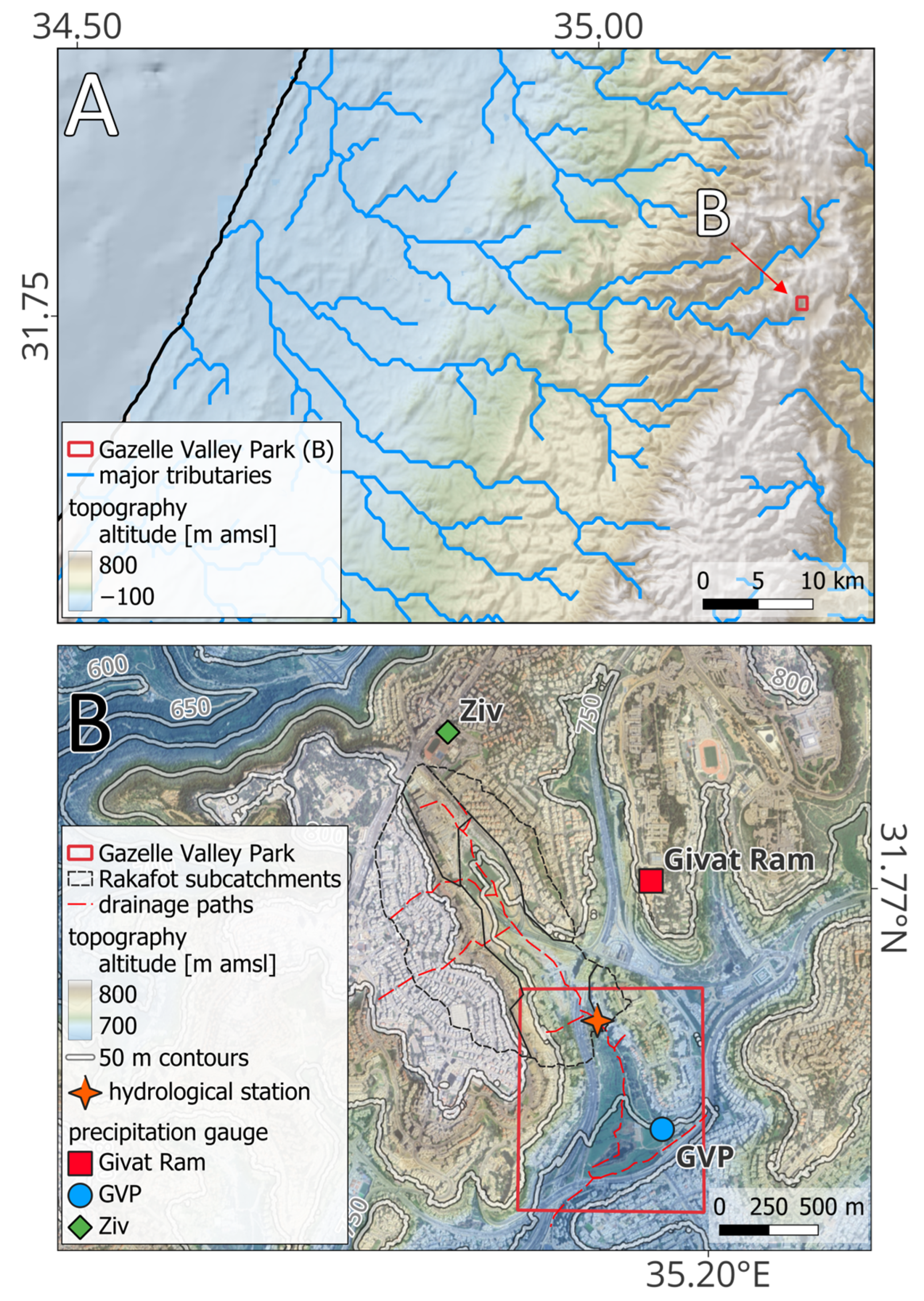
Gazelle Valley Park (GVP) is a freely accessible public park developed by the Jerusalem municipality and managed by the Society for the Protection of Nature in Israel. The park was developed on the remains of an abandoned orchard in the center of Jerusalem, and features a runoff management system designed for flood mitigation. Over the last decades, the valley was used for agriculture in the outskirts of the growing city of Jerusalem, primarily for deciduous fruit tree plantations, such as apples and pears, and accommodated a small herd of endangered gazelles (Gazella gazella). The park is located at the southern end of Rakafot Stream (catchment area ~1.2 km2; Figure S1) and comprises the northern edge of an open, semi-natural Mediterranean corridor that was once connected to the Refaim Stream (a major tributary of the Sorek Stream, which flows to the Mediterranean Sea through the Judea Mountains; Figure 3). The gazelles that reside in the surrounding open mountains and streams used to travel along the open vegetated corridor, reaching the backyards of houses in the adjacent neighborhoods of Jerusalem. As the city of Jerusalem continued to grow, the Rakafot Stream was gradually covered with roads and buildings. The valley was engulfed by built-up, dense neighborhoods, shopping malls, parking lots, and roads, and the gazelles were eventually trapped inside it, cut off from the open spaces that surround the city. The expansion of the city also increased runoff and resulted in repetitive flooding of the Malcha shopping and sports complex and raised land value, which consequently drove ambitious plans to construct dense luxury housing, putting this unique remnant open space and the gazelles residing inside it at risk [60].
The establishment of GVP despite its land’s high real-estate value is the result of a successful and lengthy public campaign carried out by the local residents with ongoing support from “green” organizations such as the Society for the Protection of Nature in Israel (SPNI), petitioning the courts and public opinion with a call for justice and nature conservation. In an unprecedented event, the development plans were abandoned, and a master plan for the valley was developed in cooperation with the city residents [60]. The implementation of the plan was supported by the park’s potential to manage urban runoff, owing to its location in a valley surrounded by heavily populated neighborhoods (Figure 3). The hydrological system was designed along the Rakafot Stream, which traverses the park from north to south, thereby demonstrating the applicability of urban nature-based solutions for water management in a Mediterranean climate (Figure 2 and Figure 4).
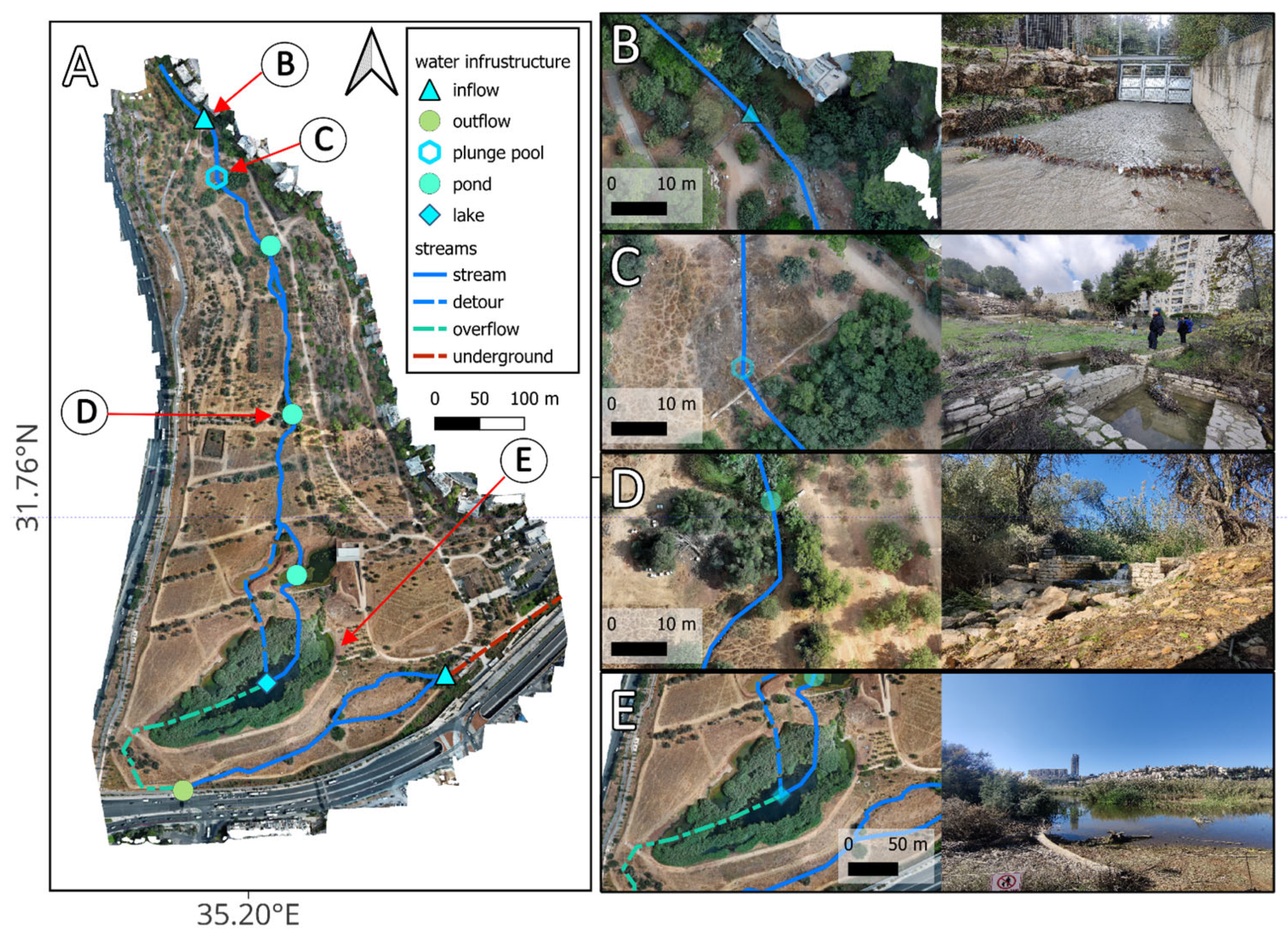
Since its establishment in 2015, GVP has become a model of ecological, social, and urban balance—meeting the needs of local communities while protecting wildlife such as gazelles and migratory birds, which enjoy a large portion of the park that was dedicated to a “natural core”, where people are not allowed to visit (Figure 4) [61,62,63]. The park was designed according to the renowned international ecological planning standards of the IUCN [64] and is therefore both a major recreational attraction for nature lovers and a case study for investigating the benefits and effectiveness of integrating ecohydrological infrastructure within the dense urban fabric [65].
The Gazelle Valley Park hydrological system thus functions as a large-scale pilot (30,000 m3 capacity) for testing the hydrological function of a large-scale NbS and the impact of alternating runoff and reclaimed wastewater on its physicochemical dynamics and ecological resilience. By monitoring and evaluating its performance, we aim to assess the broader potential of utilizing reclaimed wastewater for maintaining aquatic ecosystems as an analog for future conditions, where increased drought would require innovative solutions. We further discuss how the integration of such systems into urban blue–green spaces provides numerous ecosystem services such as flood mitigation, improvement in stormwater and reclaimed wastewater quality, mitigation of the urban heat island, and enhancement of biodiversity and ecological resilience, while providing valuable recreational spaces.

2. Materials and Methods

2.1. The Urban Hydro-Ecological System of Gazelle Valley Park

One reason behind the maintenance of such a substantial open space within the city (and for the abandonment of the ambitious and profitable development plans) was to construct a runoff collection system designed to reduce flood risk downstream in the Malcha shopping and sports complex. The park was therefore designed along a hydrological system, which follows the local topographic low of the Rakafot Stream and captures stormwater from its watershed (Figure 4). Stormwater is stored in a main reservoir at the southern part of the park (pool 1, or “the lake”), from which it is circulated through a series of small ponds that support riparian vegetation and a perennial wetland ecosystem. The impermeable nylon sheets that line the ponds’ bottoms were covered by clay in order to support the riparian vegetation system (Figure 5). The water flows between the ponds by gravity, crossing cascades and riffles, and so it is naturally filtered and aerated while supporting diverse aquatic life forms. Initial monitoring shows that this system effectively improves water quality, notably reducing water turbidity after winter storm events.
Two ephemeral, heavily engineered streams flow through the park: the Rakafot Stream, along which a water retention system was built, and the Rehavia Stream, which flows downstream along the southern edge of the park. The engineering works within the valley were carried out on the Rakafot stream to create an ecological water regulation and retention system that required considerable ingenuity. In order to prevent gazelles from escaping and predators from entering the park, for example, water enters the park through custom-built, one-directional gates that open only during flood events (Figure 5). The water then flows through the Rakafot and the Rehavia Streams that join at the southwestern edge of the park and flows into the Refaim Stream, a tributary of the Sorek Stream (Figure 3 and Figure 4).
Although no water retention system was built along the Rehavia Stream, it was modified in accordance with ecohydrological principles. The channel was split into two shallow channels in a way that promotes bank overflow during winter storms, and its banks are stabilized with mountainous stream vegetation, such as Elm (Ulmus minor subsp. canescens) and brook willow (Salix acmophylla). In the Rakafot stream, several shallow ponds (up to 1 m depth) were constructed, connected by a vegetated channel. The stormwater is collected in the large lake (~30,000 m3, ~3 m depth) at the lower part of the Rakafot Stream and pumped upstream into the small ponds, from which it flows by gravity through the vegetated channel that comprises several waterfalls and riffles for improved oxygenation.
The perennial flow along the Rakafot stream provides a key landscape feature and sustains a diverse ecosystem, supported by the mixing and continuous filtration of the water by the vegetation. The pumping of the water and its downstream flow aerate the large lake and prevent the development of anoxic conditions. Since the park’s establishment, a notable reduction in runoff load has been observed in the municipal drainage infrastructure, which further affects water quality in the Refaim Stream, draining into the Sorek and ultimately into the Mediterranean Sea.
During the first years, stormwater was sufficient to maintain the large lake and the park’s water system only for several months, as precipitation in the Mediterranean watershed is limited to a short wet season between October and May [29]. However, the aquatic environment within GVP was so successful, while providing shelter for unique migratory birds [66], that some concerns were raised about the risk posed to these threatened species, prompting the search for a solution to prevent desiccation during the dry months (June–October). Thus, the system, which was originally intended for flood mitigation and a seasonal wetland, has since been supplemented with reclaimed wastewater (following secondary treatment). While the addition of reclaimed wastewater now sustains the ecosystem year-round, it also poses challenges due to its unique physicochemical properties, such as high salinity, high organic load, and increased oxygen demand, as well as the introduction of persistent pollutants [67,68,69]. This unique setting not only poses challenges but also sets the stage to study the ecological impacts of reclaimed wastewater, as well as the effectiveness of nature-based solutions in improving water quality for potential reuse.

2.2. Hydrometric Measurements

Precipitation in the vicinity of GVP is monitored by automated tipping-bucket rain gauges. The nearest official precipitation station is located on the nearby campus of the Hebrew University at Givat Ram (Jerusalem), as part of the national precipitation monitoring network, managed by the Israeli Meteorological Service (IMS). The IMS reports rainfall data in mm at fixed time intervals (e.g., every 10 min) that can be integrated over time to calculate the amount of precipitation during the flow event. Two additional precipitation stations were installed at the upper and lower parts of the watershed at Ziv School and within GVP, respectively (Figure 3).
A hydrological measurement station was installed at the open concrete channel diverting the Rakafot Stream to the northern entrance to Gazelle Valley Park (Figure 3 and Figure 5). The channel cross-section at this segment is quasi-rectangular, with one vertical concrete wall, while its other side is a nearly flat stepped wall constructed of limestone boulders (Figure S2). All geometric parameters (cross-sectional area, hydraulic radius, and slope) were measured in the field, and Manning’s roughness coefficient for the channel was evaluated according to common reference values (Table S1 [70]). Manning’s equation was then used to derive stage–discharge estimations, which were subsequently fitted with a fourth-order polynomial to establish the rating curve applied in converting stage records into a continuous discharge series (Equation (S1)).

2.3. Geochemical Measurements

The water system was monitored using two sets of measurements. Physicochemical properties were measured in situ using a handheld multimeter (WTW model 3630, Xylem Analytics Germany, Weilheim, Germany) with electrodes for measuring electrical conductivity, dissolved oxygen, pH, and temperature. The electrodes were calibrated following standard procedures and verified against reference solutions (e.g., buffers of known pH). The measurements were recorded after all electrodes stabilized, and the maximum temperature difference between any pair of electrodes was less than 0.2 °C.
Samples for chemical analyses were also collected from the park for detailed laboratory measurements at the nearby Geological Survey of Israel (GSI). Sampling locations included the inflowing water from the Rakafot and Rehavia Streams and key points along the hydrological system of GVP (i.e., its lake, pools, and connecting stream; Figure 5). Additional sampling of rainwater took place from a bucket placed on the roof of the nearby GSI, whereas reclaimed wastewater was sampled from the hose feeding the GVP water system. Sampling was performed using several bottles for determining salinity, alkalinity, and major ion profile (~100 mL of unfiltered sample), as well as trace element content. Sampling for trace elements was carried out by filtering (<45 µm) ~50 mL of water into a pre-cleaned Nalgene bottle spiked with HNO3 at a 1:5 ratio (Pico-Pure 67–69%). An additional Nalgene bottle was filled with ~50 mL of unfiltered water and spiked with 2 N HNO3 in order to release adsorbed ions from solid particles. This sampling scheme enabled the measurement of the dissolved and adsorbed fractions on the filtered and unfiltered samples, respectively. Chloride and alkalinity were determined using standard titration procedures with 0.1 N AgNO3 (702 SM Titrino, Metrohm AG, Herisau, Switzerland) and 0.02 N HCl (785 DMT Titrino, Metrohm AG, Herisau, Switzerland), respectively. Major cations were determined by ICP-OES (Avio 500 Max, PerkinElmer, Shelton, CT, USA), and trace elements were determined by ICP-MS (Nexion 300D, PerkinElmer, CT, USA), calibrated using commercial elemental solutions (e.g., MERCK VI multi-element standard (Merck KGaA, Darmstadt, Germany), and the USGS water reference material). Additional anions were determined by ion chromatography (Dionex ICS-2100, Thermofisher, Waltham, MA, USA).

3. Results

3.1. Hydrological Measurements

Precipitation over the Rakafot watershed occurred in discrete storms, typically during extra-tropical cyclones, locally known as Mediterranean Cyclones (or Mediterranean Lows) [71]. The total precipitation in a single storm event, measured at Givat Ram, ranged between 0.8 and 107 mm, with mean and median values of 25 and 14 mm, respectively. The maximum 10 min rainfall intensity within storms ranged between 2 and 35 mm·h−1 with a mean of 12 mm·h−1, and a median of 8 mm·h−1. Rain events lasted between 24.5 h (November 2023) and 203.5 h (January 2024), with average and median durations of 70 and 60.5 h, respectively.
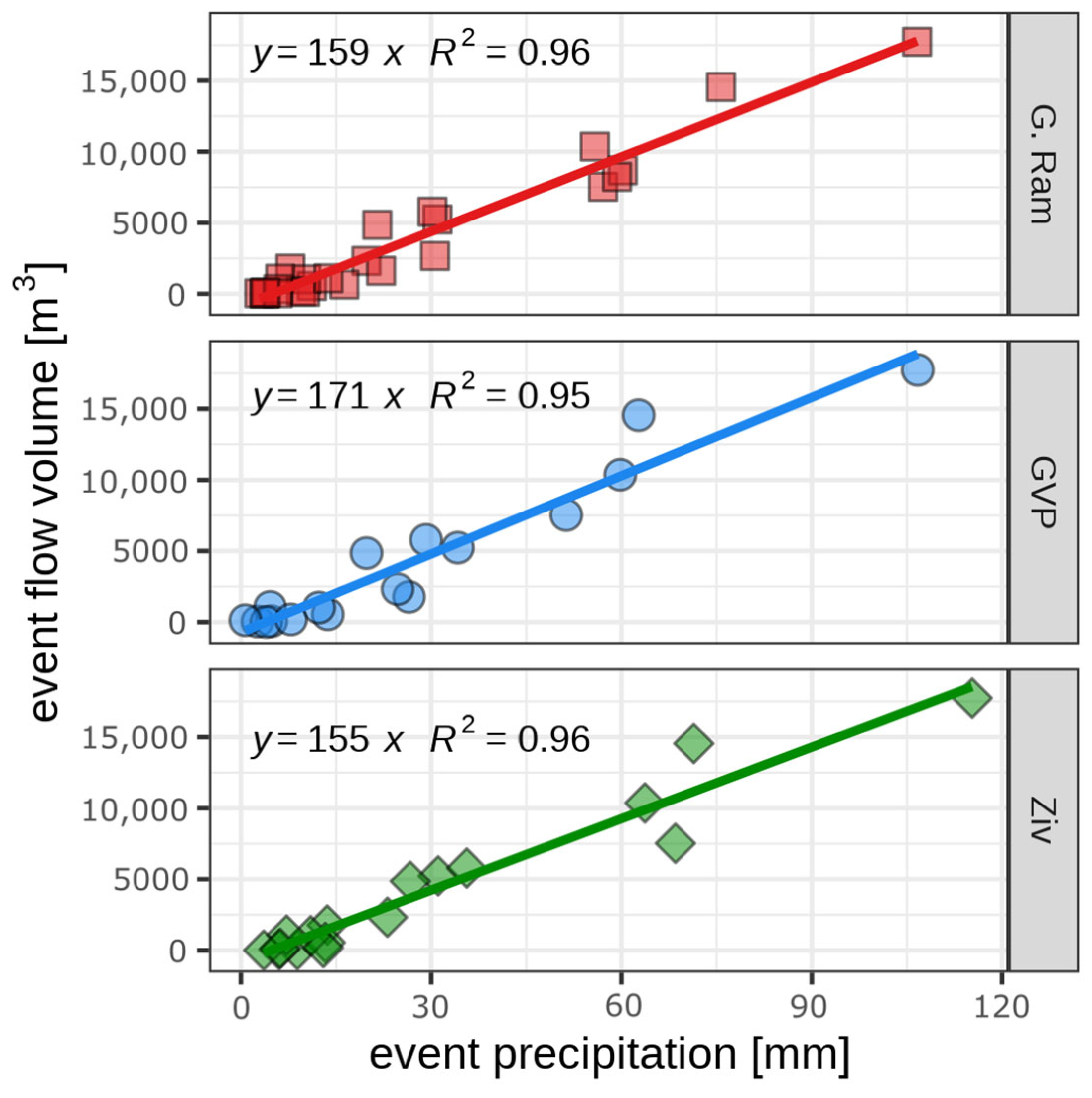
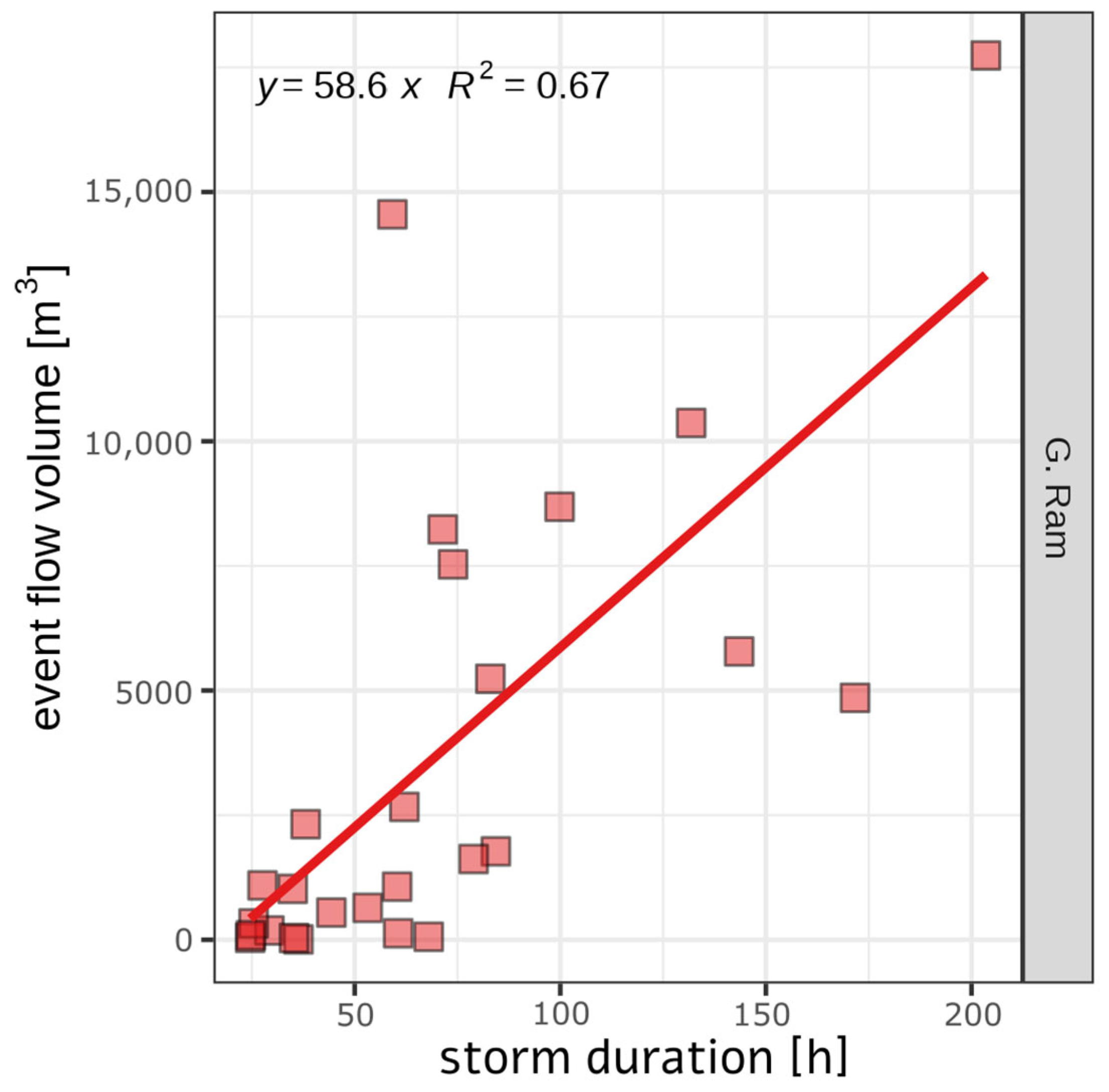
A total of 27 flow events were recorded during the study period. All flows occurred between November and March, except for a single flow recorded in May 2025. The cumulative flow volume ranged between 8 m3 (March 2024) and 17,738 m3 (January 2024) with average and median values of 3964 m3 and 1621 m3, respectively. Flow volume and precipitation are highly correlated with (r2 > 0.95 for all precipitation stations; Figure 6), whereas the total stormwater volume is only moderately correlated with precipitation duration (r2 = 0.67; Figure 7). The correlation between maximum 10 min rainfall intensity and peak discharge varied among the different precipitation stations (Figure 8), where the nearby Givat Ram station had the lowest correlation (r2 = 0.66), and the station within GVP had the highest correlation (r2 = 0.85). Peak discharge ranged between 0.024 m3·s−1 (March 2024) and 0.897 m3·s−1 (February 2025), with average and median values of 0.305 m3·s−1 and 0.218 m3·s−1, respectively.

3.2. Hydrochemical Dynamics

A clear annual cycle is observed in the physicochemical water properties across GVP. Overall, stormwater is characterized by lower temperature, increased dissolved oxygen content, higher pH, and lower conductivity compared with reclaimed wastewater (~400 µS·cm−1 vs. ~1500 µS·cm−1; Figure 9). The uniformity of both temperature and conductivity across various sampling sites within GVP indicates that the circulation system effectively mixes the water collected in the large “lake”. Falling oxygen levels in the small ponds during spring, decreasing from ~7 mg·L−1 to ~0 mg·L−1, suggest that increased oxygen demand due to the introduction of reclaimed wastewater depletes dissolved oxygen in these small ponds. However, the flow of the water through the stream and the surface area of the large lake allow some segments of the system to maintain elevated dissolved oxygen levels year-round in these parts (~6 mg·L−1; Figure 9).
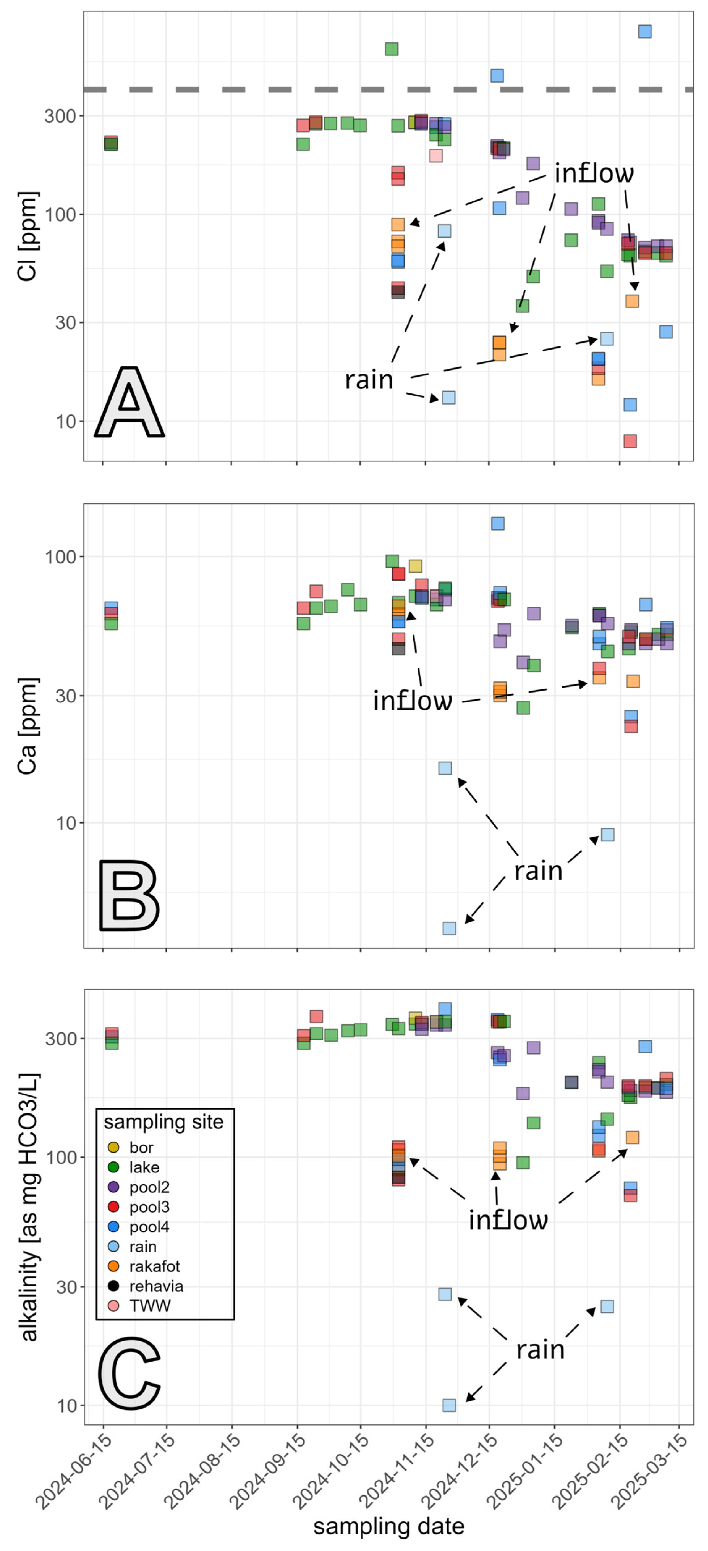
The water composition in the GVP system is generally of low salinity (TDS < 0.1%) and moderate chloride concentrations (up to 300 ppm). Rainwater and inflow exhibit moderate chloride levels (10–100 ppm) and TDS (10–300 ppm), highlighting the significant role of reclaimed wastewater in contributing to the salinity load of the hydrological system (Figure 10).
By the end of the dry season, metal concentrations in the GVP water system generally remain within regulatory limits (Figure 11 [72]). However, inflowing floodwater is enriched with various metal elements, most of which are delivered in an adsorbed form and are only labile under acid leaching, rather than in dissolved form, as indicated by the large differences between the dissolved and acid-labile fractions, determined on the filtered and unfiltered samples, respectively. The concentrations of some metals exceed the recommended threshold for drinking water in Israel (e.g., Al, Fe, and Mn), with values ranging from <10 to 106 ppb (Figure 11). Nevertheless, the composition of water in the lake does not vary substantially due to its large reservoir volume.

4. Discussion

4.1. Potential and Risk in Urban Stormwater and Reclaimed Wastewater

Gazelle Valley Park provides an excellent example of the potential for incorporating nature-based solutions (NbSs) into a dense urban environment, offering a spacious open area that serves multiple functions. First and foremost, its hydrological system collects the majority of urban runoff generated in the Rakafot watershed during the wet season, with limited overflow that occurs only rarely at the end of winter, typically when two significant storms occur in close succession.
The catchment response to precipitation is typical of urban environments, where total precipitation is strongly correlated with inflow volume (R2 > 0.95), although the correlation between 10 min maximum rainfall intensity and peak discharge is somewhat lower (R2 = 0.65–0.85). These correlations indicate that infiltration and storage processes play only a minor role in catchment hydrology, as the drainage network rapidly conveys precipitation downstream. This response is further amplified by the catchment’s elevated topography and steep slopes, which accelerate water flow. Moreover, runoff is generated even during relatively small rainfall events and low precipitation intensities, highlighting the high sensitivity of urban catchments with extensive impervious surfaces [3].
However, despite these characteristics, the calculated mean runoff coefficient was lower than typical values for urban areas, ranging from 0.09 to 0.14, with slight variations between the different rainfall gauge [73]. This discrepancy highlights the difficulty of accurately delineating contributing areas in densely built environments. Subsurface drainage systems can modify the effective runoff-contributing area by diverting water outside the topographic catchment [74,75], emphasizing the need to consider engineered drainage pathways in addition to topographic boundaries when delineating runoff-contributing areas in urban watersheds.
While accurately delineating runoff-contributing areas in dense urban settings remains challenging, the case of GVP demonstrates the potential of urban green–blue spaces to mitigate negative stormwater impacts. Similar designs in other urban parks have incorporated retention ponds, permeable vegetated zones, and wetland systems that enhance retention and infiltration processes, thereby moderating runoff peaks and volumes [76]. Although the current monitoring setup records only the inflow from the Rakafot catchment to the park, expanding hydrometric observations in the future to include all inflows and outflows will be essential for accurately quantifying the park’s contribution to flood mitigation and peak attenuation.
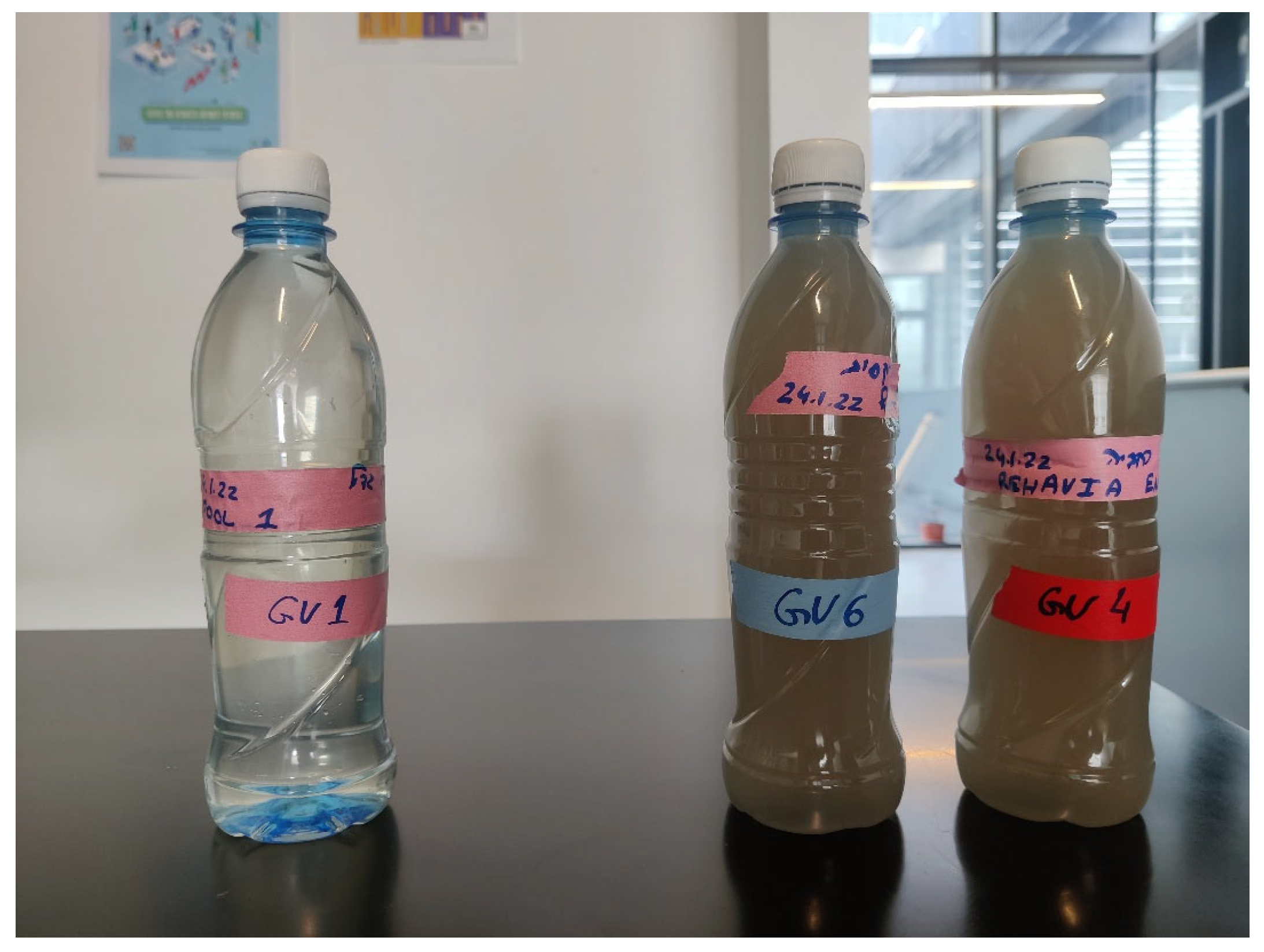
The construction of the GVP hydrological system not only reduces the load on local drainage infrastructure during storm events, but also decreases downstream pollution through the settling of particles and filtering of water, as evidenced by the color and clarity of water collected during storm events (Figure 12). Because the majority of metal pollution is found in adsorbed form, particle settling effectively removes most of it, highlighting its importance.
During the summer, as temperatures rise (~7 °C vs. ~25 °C) and reclaimed wastewater is introduced into the system, a clear oxygen deficit develops in the small ponds, reducing dissolved oxygen levels to ~0 mg·L−1. Together with increasing salinity, these variations impose new conditions on the entire ecosystem, and its stability is jeopardized. Indeed, it was noted during sampling that the oxygen-deprived pools are infested with diptera larvae such as Chironomidae (e.g., Chironomus plumosus) and Culicidae (e.g., Culex pipiens) due to their ability to endure anoxic conditions [77]. This is also because the majority of heavy metal pollution that reaches GVP is adsorbed onto particles and could be released under the developing anoxic conditions. This highlights the need for improved filtration and removal of particles, either in plunge pools or by constructing additional filtration systems. The incorporation of a “bio-filter” [78], or more advanced filters, such as combined clay and polymers [79,80], within the water system has the potential not only to improve pollutant removal but also to lower its organic load and improve its oxygenation, thereby increasing the resilience and sustainability of the ecosystem.

4.2. Urban Ecological Resilience

Gazelle Valley Park provides an open ecological niche that supports a diverse ecosystem for endangered gazelles, reptiles, migratory birds, invertebrates, and plants. Generally speaking, landscaping and vegetation maintenance in the park follow a nature-oriented approach, with minimal intervention in order to reduce maintenance costs, while creating a “semi-natural” environment. Aside from the hydrological system, which was built to establish a local wetland, the planting of new plants and their maintenance are limited to the areas open to the public, where trees are pruned sparingly, and dry grasses and therophytes are removed only to reduce fire risk. Overall, a visit to the park immerses the visitors in a semi-natural, extensive setting, contrasting with the intensive, heavily planned urban landscaping that typically incorporates a mixture of non-native plant species. In this semi-natural landscape, gazelles are free to roam across the open, steppe-like landscape (Figure 4 and Figure 5).
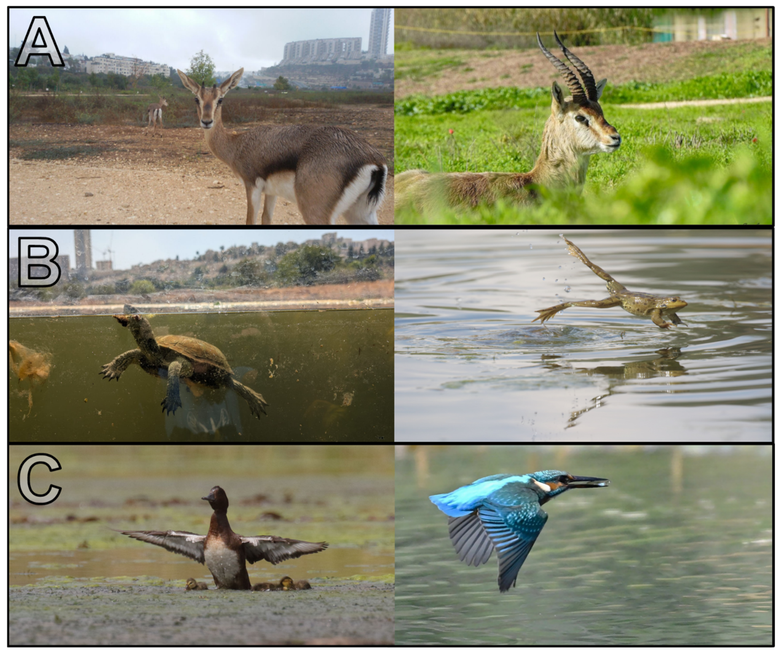
The large area of the park provides shelter and numerous niches for different animals, forming an independent and resilient ecological web that serves as a strong natural core within the city (Figure 13). Gazelles and birds offer recreational opportunities for wildlife observation and birdwatching, while insects and birds spread from the park to adjacent areas (Figure 3). Since the establishment of the park ten years ago, gazelles have successfully reproduced, enabling young individuals to be released by the Society for the Protection of Nature in Israel and the Israel Nature and Parks Authority into wild regions where their population has severely declined. Additionally, the park’s large open blue–green space helps mitigate the urban heat island effect through its vegetated area and moisture contribution from the hydrological system, which provides another substantial benefit for the nearby residents and visitors.

4.3. Education and Public Engagement

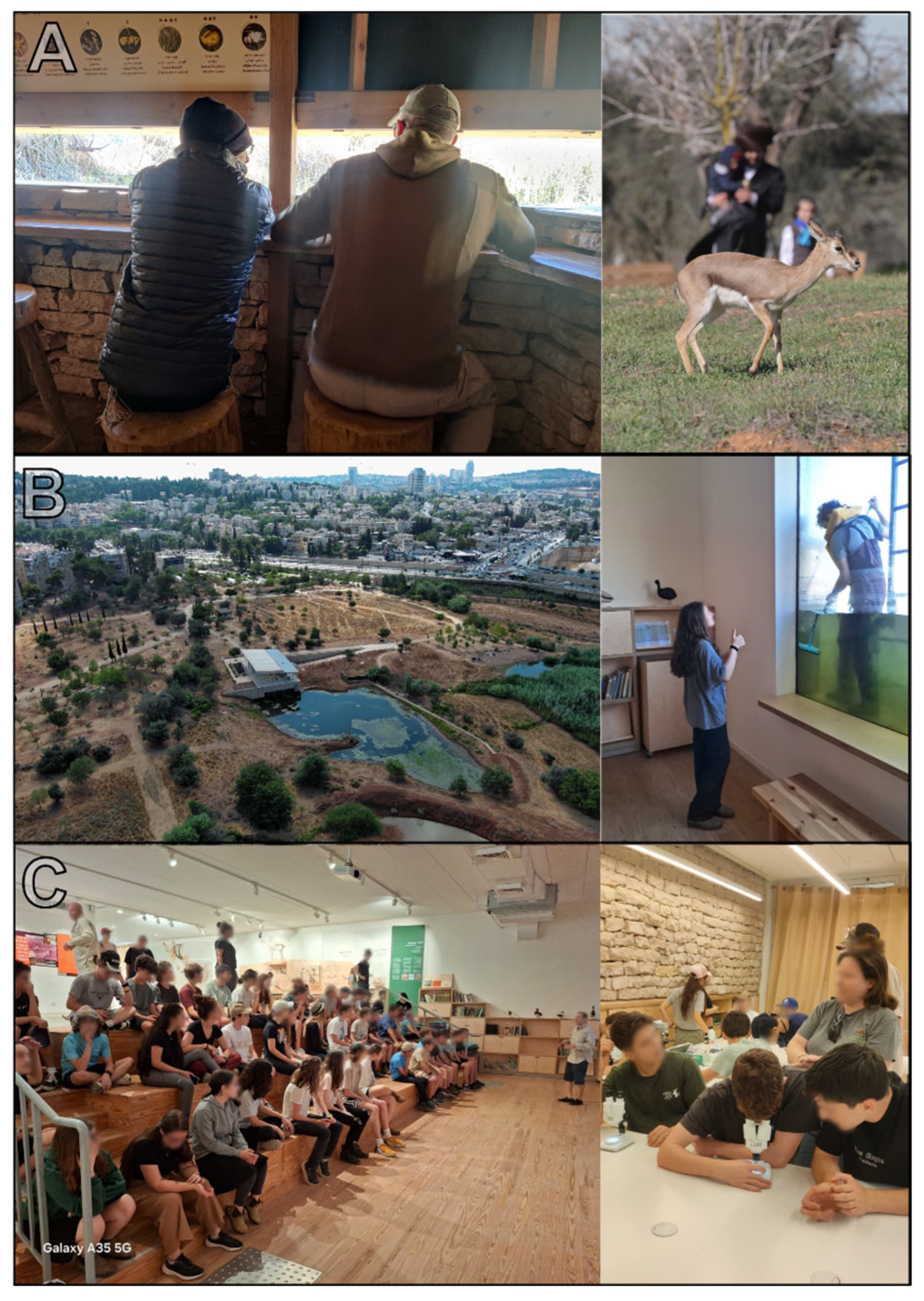
Gazelle Valley Park also plays an important role in the education of visitors and school pupils. The visitors can observe the animals from walking trails, hideouts, and benches (Figure 14). A key principle in the ecological restoration process of Gazelle Valley Park follows the idea that “if you build it, they will come”. Creating a clean and high-quality natural environment in terms of landscaping, maintenance and vegetation encourages the natural return of wildlife and enhances biodiversity. The same principle is emphasized in the design of physical infrastructure. For example, a natural core zone closed to visitors is only marked by a simple rope, accompanied by educational explanations of is importance by park personnel. Although this barrier is held by a single symbolic yellow rope that cannot physically stop visitors from crossing over into the protected natural core, visitors have learned to respect this separation between wildlife and people, thus enabling sensitive ecosystems to persist within the heart of the city. Even elements sometimes perceived as “less attractive”, such as spiky summer thistles, are presented as integral components of the ecosystem, supporting species such as the European goldfinch (Carduelis carduelis). This understanding reshapes visitors’ relationships with the landscape and deepens their sense of connection and responsibility toward it.
Over the course of 2024–2025, a new ambitious education and research center was constructed next to one of the ponds. The building was excavated to reach the bottom of the pond so that the visitors could explore the entire water column as if visiting an urban underwater observatory. The new education center provides an unprecedented opportunity for the public to observe the impact of the annual hydroclimatic cycle on wildlife from a unique perspective without disturbing it. Within the education center, visitors can explore exhibitions highlighting key aspects of the civil efforts that led to the establishment of the park, as well as learn about the wildlife and the natural setting of the park. The observation center also includes a laboratory that serves the city’s school system by providing in-depth scientific education on the biological and chemical aspects of the urban water cycle. This initiative helps promote the importance of nature conservation and demonstrates the role that nature-based solutions and large semi-natural parks can play in the design of future urban environments.
The principle of “if you build it, they will come” further guides the development of educational content and activities as a core component in GVP. By creating diverse opportunities, visitors can engage with urban nature in ways that suit their interests. Interaction may be brief or in-depth—ranging from reading an informational sign, self-guided exploration, and a staff-led encounter to participating in cultural events—while the core value of nature conservation is consistently reinforced (Figure 14). The educational focus extends beyond the “transmission of knowledge” to fostering direct engagement that integrates scientific understanding with emotional connection. Additionally, the park serves as a field site for research projects, citizen-science initiatives, and collaborations with academic researchers, with outcomes translated into content accessible to the broader public. The overarching aspiration is that every visitor will experience at least one educational interaction that imparts their knowledge, inspiration, and a sense of responsibility toward nature.

5. Conclusions

The design and construction of an urban NbS within the crowded metropolitan area of Jerusalem, through the establishment of Gazelle Valley Park, provides a prime example of the role of public activism in maintaining natural and open spaces. The park offers an exceptional semi-natural environment that helps mitigate flood risk and reduce the urban heat island effect under a Mediterranean climate. Today, GVP not only reduces flood risk and improves downstream water quality but also serves as an accessible hub for education and culture, exemplifying the successful integration of community needs and urban design. The park’s management illustrates how continuous learning and adaptive management are used to assess the many facets of an urban NbS, including hydrology, fauna, flora, education, and public outreach. Key conclusions arise from its investigation:
  • Precipitation is linearly correlated with inflow volume (R2 = 0.95–0.96), as typically observed in urban environments, indicating that infiltration and storage processes play only a minor role in catchment hydrology.
  • Runoff is generated even during relatively small rainfall events and low precipitation intensities, highlighting the high sensitivity of urban catchments with extensive impervious surfaces, which is critical for risk assessment under future climate scenarios.
  • The mean runoff coefficient is lower than typical values for urban areas, reflecting the difficulty of accurately delineating runoff-generating zones in dense urban environments and the influence of subsurface drainage systems in diverting water outside topographic catchments.
  • During summer, the introduction of reclaimed wastewater and rising temperatures (~7 °C to ~25 °C) reduce dissolved oxygen in small ponds, jeopardizing ecosystem stability resulting in dipteran larvae infestations.
  • Most heavy metal pollution reaching GVP is adsorbed onto particles, emphasizing the need for improved filtration and particle-settling processes. The hydrological system of GVP reduces downstream pollution through the settling of particles and the water filtration.
  • Incorporation of a biofilter or a combined clay-polymer filter within the park’s water system has the potential to enhance pollutant removal, reduce organic load, and improve oxygenation, thereby contributing to its ecosystem resilience.
  • The park benefits substantially from its multi-disciplinary design and operation, where hydrology, ecology, education, and public engagement are integrated. By considering these many facets, the park demonstrates that “the whole is greater than the sum of its parts.”

Supplementary Materials

The following supporting information can be downloaded at: https://www.mdpi.com/article/10.3390/land14112174/s1, Figure S1: Rakafot Stream catchment; Figure S2: Photographs of the Rakafot Stream; Table S1: Hydraulic parameters; Equation (S1): stage-to-discharge polynomial rating curve.

Author Contributions

Conceptualization, Y.B.; methodology, Y.B., G.S., S.A., R.N., E.M., R.O., E.F. and E.L.; validation, Y.B., G.S., S.A., R.N. and E.M.; formal analysis, Y.B., R.N. and E.M.; investigation, Y.B., R.N. and R.O.; resources, Y.B., E.M. and E.L.; data curation, Y.B., G.S., S.A. and R.N.; writing—original draft preparation, Y.B., R.N., I.S. and G.S.; writing—review and editing, Y.B., G.S., S.A., R.N., E.M., R.O., E.F., E.L., I.S., A.B. and A.L.; visualization, Y.B.; supervision, Y.B., E.M. and E.L.; project administration, Y.B., E.M. and E.L.; funding acquisition, Y.B., E.M. and E.L. All authors have read and agreed to the published version of the manuscript.

Funding

This research was funded by the Ministry of Agriculture and Food Security of Israel, grant number 77-21-0003, and the APC was covered by an invitation by MDPI to contribute to this Special Issue.

Data Availability Statement

The data presented in this publication is available within the article and the Supplementary Material and upon request.

Acknowledgments

The presented article was supported by the work and contribution of staff at the Geological Survey of Israel, the Hebrew University of Jerusalem, and Ben-Gurion University, as well as through constant support by GVP staff. We thank the Gazelle Valley Park team for their dedicated and ongoing support of GVP and their contribution of images used in the paper. Liran Ben-Moshe is thanked for drone images and mapping.

Conflicts of Interest

The authors declare no conflicts of interest. The funders had no role in the design of the study; in the collection, analyses, or interpretation of data; in the writing of the manuscript; or in the decision to publish the results.

Abbreviations

The following abbreviations are used in this manuscript:
GVPGazelle Valley Park
SPNISociety for the Protection of Nature in Israel
GSIGeological Survey of Israel
NbSsNature-based Solutions

References

  1. Carmon, N.; Shamir, U. Water-sensitive planning: Integrating water considerations into urban and regional planning. Water Environ. J. 2010, 24, 181–191. [Google Scholar] [CrossRef]
  2. Fletcher, T.D.; Andrieu, H.; Hamel, P. Understanding, management and modelling of urban hydrology and its consequences for receiving waters: A state of the art. Adv. Water Resour. 2013, 51, 261–279. [Google Scholar] [CrossRef]
  3. Fletcher, T.D.; Burns, M.J.; Russell, K.L.; Hamel, P.; Duchesne, S.; Cherqui, F.; Roy, A.H. Concepts and evolution of urban hydrology. Nat. Rev. Earth Environ. 2024, 5, 789–801. [Google Scholar] [CrossRef]
  4. Oswald, C.J.; Kelleher, C.; Ledford, S.H.; Hopkins, K.G.; Sytsma, A.; Tetzlaff, D.; Toran, L.; Voter, C. Integrating urban water fluxes and moving beyond impervious surface cover: A review. J. Hydrol. 2023, 618, 129188. [Google Scholar] [CrossRef]
  5. Chen, X.-L.; Zhao, H.-M.; Li, P.-X.; Yin, Z.-Y. Remote sensing image-based analysis of the relationship between urban heat island and land use/cover changes. Remote Sens. Environ. 2006, 104, 133–146. [Google Scholar] [CrossRef]
  6. Norton, B.A.; Coutts, A.M.; Livesley, S.J.; Harris, R.J.; Hunter, A.M.; Williams, N.S. Planning for cooler cities: A framework to prioritise green infrastructure to mitigate high temperatures in urban landscapes. Landsc. Urban Plan. 2015, 134, 127–138. [Google Scholar] [CrossRef]
  7. Yin, Z.; Liu, Z.; Liu, X.; Zheng, W.; Yin, L. Urban heat islands and their effects on thermal comfort in the US: New York and New Jersey. Ecol. Indic. 2023, 154, 110765. [Google Scholar] [CrossRef]
  8. Piracha, A.; Chaudhary, M.T. Urban air pollution, urban heat island and human health: A review of the literature. Sustainability 2022, 14, 9234. [Google Scholar] [CrossRef]
  9. Aris, A.Z.; Shamsuddin, A.S.; Praveena, S.M. Occurrence of 17α-ethynylestradiol (EE2) in the environment and effect on exposed biota: A review. Environ. Int. 2014, 69, 104–119. [Google Scholar] [CrossRef]
  10. Carey, R.O.; Hochmuth, G.J.; Martinez, C.J.; Boyer, T.H.; Dukes, M.D.; Toor, G.S.; Cisar, J.L. Evaluating nutrient impacts in urban watersheds: Challenges and research opportunities. Environ. Pollut. 2013, 173, 138–149. [Google Scholar] [CrossRef]
  11. Line, D.; White, N. Effects of development on runoff and pollutant export. Water Environ. Res. 2007, 79, 185–190. [Google Scholar] [CrossRef]
  12. Zinger, Y.; Deletic, A.; Fletcher, T.; Breen, P.; Wong, T. A dual-mode biofilter system: Case study in Kfar Sava, Israel. In Proceedings of the 12th International Conference on Urban Drainage, Porto Alegre, Brazil, 18–21 April 2011. [Google Scholar]
  13. Grodek, T.; Lange, J.; Lekach, J.; Husary, S. Urban hydrology in mountainous middle eastern cities. Hydrol. Earth Syst. Sci. 2011, 15, 953–966. [Google Scholar] [CrossRef]
  14. European Parliament Council. Directive 2000/60/EC—Water Framework Directive (WFD); European Parliament Council: Brussels, Belgium, 2000. Available online: https://eur-lex.europa.eu/eli/dir/2000/60/oj/eng (accessed on 12 October 2025).
  15. United States Congress. Clean Water Act; United States Congress: Washington, DC, USA, 1972. Available online: https://www.govinfo.gov/content/pkg/STATUTE-86/pdf/STATUTE-86-Pg816.pdf (accessed on 12 October 2025).
  16. State of Israel. Drainage and Flood Control Law, 5718-1957 (Israel); State of Israel: Jerusalem, Israel, 1957. Available online: https://faolex.fao.org/docs/pdf/isr4238E.pdf (accessed on 12 October 2025).
  17. State of Israel. Water Law, 5719-1959 (Israel); State of Israel: Jerusalem, Israel, 1959; Available online: https://faolex.fao.org/docs/pdf/isr1321.pdf (accessed on 12 October 2025).
  18. European Council. Council Directive 91/271/EEC—Urban Waste Water Treatment Directive (UWWTD); European Council: Brusseles, Belgium, 1991. Available online: https://eur-lex.europa.eu/legal-content/EN/ALL/?uri=celex%3A31991L0271 (accessed on 12 October 2025).
  19. European Parliament Council. Directive 2007/60/EC—Floods Directive; European Parliament Council: Brussels, Belgium, 2007. Available online: https://eur-lex.europa.eu/eli/dir/2007/60/oj (accessed on 12 October 2025).
  20. U.S. Environmental Protection Agency. EPA—Compendium of MS4 Permitting Approaches (Off-site Stormwater Management); U.S. Environmental Protection Agency: Washington, DC, USA, 2022. Available online: https://www.epa.gov/system/files/documents/2023-01/off-site-stormwater-management-MS4-compendium.pdf (accessed on 12 October 2025).
  21. U.S. Environmental Protection Agency. EPA—Stormwater Management Program (SWMP) Template; U.S. Environmental Protection Agency: Washington, DC, USA, 2019. Available online: https://www.epa.gov/sites/default/files/2019-06/documents/r10-npdes-pocatello-ua-ms4-ids028053-appendix-b1-swmp-template.pdf (accessed on 12 October 2025).
  22. U.S. Environmental Protection Agency. EPA—Stormwater Discharges from Municipal Sources (MS4 Guidance); U.S. Environmental Protection Agency: Washington, DC, USA, 2023. Available online: https://www.epa.gov/npdes/stormwater-discharges-municipal-sources (accessed on 12 October 2025).
  23. U.S. Environmental Protection Agency. EPA Stormwater Phase II Final Rule Fact Sheet Series; U.S. Environmental Protection Agency: Washington, DC, USA, 2005. Available online: https://www.epa.gov/npdes/stormwater-phase-ii-final-rule-fact-sheet-series (accessed on 12 October 2025).
  24. Tel Aviv-Yafo Municipality. Tel Aviv-Yafo Climate Adaptation Action Plan; Tel Aviv-Yafo Municipality: Tel Aviv, Israel, 2019. Available online: https://www.tel-aviv.gov.il/en/Documents/Climate%20Adaptation%20Action%20Plan.pdf (accessed on 12 October 2025).
  25. Israel Ministry of Environmental Protection. Climate Change Info Center—Plan Outline for Local Authorities (Israel Ministry of Environmental Protection); Israel Ministry of Environmental Protection: Jerusalem, Israel, 2013. Available online: https://www.gov.il/BlobFolder/reports/climate_change_info_center_report3/he/research_sviva_climate_change_climate_change_info_center_plan_outline_for_local_authorities_2013.pdf (accessed on 12 October 2025).
  26. Ashley, R.; Walker, L.; D’Arcy, B.; Wilson, S.; Illman, S.; Shaffer, P.; Woods-Ballard, B.; Chatfield, P. UK sustainable drainage systems: Past, present and future. Proc. Inst. Civ. Eng. Civ. Eng. 2015, 168, 125–130. [Google Scholar] [CrossRef]
  27. Shamir, U.; Carmon, N. Water-Sensitive Planning: Integrating Water Considerations into Urban and Regional Planning; Israel Institute of Technology (Technion): Haifa, Israel, 2007; p. 301. Available online: https://shamir.net.technion.ac.il/files/2012/03/water-sensitive-planning-book.pdf (accessed on 29 September 2022).
  28. Starkey, E.; Rollason, E.; Cotterill, S.; Sreenivas, P.; Bracken, L. Maximising urban resilience using sustainable drainage systems (SuDS): Making the case for community-led urban water management. Land Use Policy 2025, 158, 107732. [Google Scholar] [CrossRef]
  29. Kushnir, Y.; Dayan, U.; Ziv, B.; Morin, E.; Enzel, Y. Climate of the Levant. In Quaternary of the Levant; Enzel, Y., Bar-Yosef, O., Eds.; Cambridge University Press: Cambridge, UK, 2017; pp. 31–44. [Google Scholar] [CrossRef]
  30. Ben Dor, Y.; Armon, M.; Ahlborn, M.; Morin, E.; Erel, Y.; Brauer, A.; Schwab, M.J.; Tjallingii, R.; Enzel, Y. Changing flood frequencies under opposing late Pleistocene eastern Mediterranean climates. Sci. Rep. 2018, 8, 8445. [Google Scholar] [CrossRef] [PubMed]
  31. Marra, F.; Armon, M.; Adam, O.; Zoccatelli, D.; Gazal, O.; Garfinkel, C.I.; Rostkier-Edelstein, D.; Dayan, U.; Enzel, Y.; Morin, E. Toward Narrowing Uncertainty in Future Projections of Local Extreme Precipitation. Geophys. Res. Lett. 2021, 48, e2020GL091823. [Google Scholar] [CrossRef]
  32. Morin, E.; Harats, N.; Jacoby, Y.; Arbel, S.; Getker, M.; Arazi, A.; Grodek, T.; Ziv, B.; Dayan, U. Studying the extremes: Hydrometeorological investigation of a flood-causing rainstorm over Israel. Adv. Geosci. 2007, 12, 107–114. [Google Scholar] [CrossRef]
  33. Armon, M.; Marra, F.; Enzel, Y.; Rostkier-Edelstein, D.; Garfinkel, C.I.; Adam, O.; Dayan, U.; Morin, E. Reduced rainfall in future heavy precipitation events related to contracted rain area despite increased rain rate. Earth’s Future 2022, 10, e2021EF002397. [Google Scholar] [CrossRef]
  34. Hochman, A.; Mercogliano, P.; Alpert, P.; Saaroni, H.; Bucchignani, E. High-resolution projection of climate change and extremity over Israel using COSMO-CLM. Int. J. Climatol. 2018, 38, 5095–5106. [Google Scholar] [CrossRef]
  35. Hochman, A.; Alpert, P.; Kunin, P.; Rostkier-Edelstein, D.; Harpaz, T.; Saaroni, H.; Messori, G. The dynamics of cyclones in the 21st century: The Eastern Mediterranean as an example. Clim. Dyn. 2020, 54, 561–574. [Google Scholar] [CrossRef]
  36. Reale, M.; Cabos Narvaez, W.D.; Cavicchia, L.; Conte, D.; Coppola, E.; Flaounas, E.; Giorgi, F.; Gualdi, S.; Hochman, A.; Li, L. Future projections of Mediterranean cyclone characteristics using the Med-CORDEX ensemble of coupled regional climate system models. Clim. Dyn. 2022, 58, 2501–2524. [Google Scholar] [CrossRef]
  37. Yosef, Y.; Aguilar, E.; Alpert, P. Changes in extreme temperature and precipitation indices: Using an innovative daily homogenized database in Israel. Int. J. Climatol. 2019, 39, 5022–5045. [Google Scholar] [CrossRef]
  38. Zappa, G.; Hawcroft, M.K.; Shaffrey, L.; Black, E.; Brayshaw, D.J. Extratropical cyclones and the projected decline of winter Mediterranean precipitation in the CMIP5 models. Clim. Dyn. 2015, 45, 1727–1738. [Google Scholar] [CrossRef]
  39. Beck, H.E.; McVicar, T.R.; Vergopolan, N.; Berg, A.; Lutsko, N.J.; Dufour, A.; Zeng, Z.; Jiang, X.; van Dijk, A.I.; Miralles, D.G. High-resolution (1 km) Köppen-Geiger maps for 1901–2099 based on constrained CMIP6 projections. Sci. Data 2023, 10, 724. [Google Scholar] [CrossRef]
  40. Saaroni, H.; Ben-Dor, E.; Bitan, A.; Potchter, O. Spatial distribution and microscale characteristics of the urban heat island in Tel-Aviv, Israel. Landsc. Urban Plan. 2000, 48, 1–18. [Google Scholar] [CrossRef]
  41. Zalewski, M.; Kiedrzyńska, E.; Wagner, I.; Izydorczyk, K.; Boczek, J.M.; Jurczak, T.; Krauze, K.; Frankiewicz, P.; Godlewska, M.; Wojtal-Frankiewicz, A. Ecohydrology and adaptation to global change. Ecohydrol. Hydrobiol. 2021, 21, 393–410. [Google Scholar] [CrossRef]
  42. European Environment Agency. Nature-Based Solutions in Europe Policy, Knowledge and Practice for Climate Change Adaptation and Disaster Risk Reduction; European Environment Agency Publications Office: Copenhagen, Denmark, 2021. Available online: https://data.europa.eu/doi/10.2800/919315 (accessed on 12 October 2025). [CrossRef]
  43. Esraz-Ul-Zannat, M.; Dedekorkut-Howes, A.; Morgan, E.A. A review of nature-based infrastructures and their effectiveness for urban flood risk mitigation. Wiley Interdiscip. Rev. Clim. Change 2024, 15, e889. [Google Scholar] [CrossRef]
  44. Ruangpan, L.; Vojinovic, Z.; Di Sabatino, S.; Leo, L.S.; Capobianco, V.; Oen, A.M.; McClain, M.E.; Lopez-Gunn, E. Nature-based solutions for hydro-meteorological risk reduction: A state-of-the-art review of the research area. Nat. Hazards Earth Syst. Sci. 2020, 20, 243–270. [Google Scholar] [CrossRef]
  45. Huang, Y.; Tian, Z.; Ke, Q.; Liu, J.; Irannezhad, M.; Fan, D.; Hou, M.; Sun, L. Nature-based solutions for urban pluvial flood risk management. Wiley Interdiscip. Rev. Water 2020, 7, e1421. [Google Scholar] [CrossRef]
  46. Goulden, S.; Portman, M.E.; Carmon, N.; Alon-Mozes, T. From conventional drainage to sustainable stormwater management: Beyond the technical challenges. J. Environ. Manag. 2018, 219, 37–45. [Google Scholar] [CrossRef] [PubMed]
  47. Kiedrzyńska, E.; Belka, K.; Jarosiewicz, P.; Kiedrzyński, M.; Zalewski, M. The enhancement of valley water retentiveness in climate change conditions. Sci. Total Environ. 2021, 799, 149427. [Google Scholar] [CrossRef]
  48. Markus, L.; Gazit, A.; Carmon, N. The Use of Road Runoff for Ecological and Societal Benefits by Water-Sensitive Planning. 2015, pp. 8–15. Available online: https://www.researchgate.net/publication/319182886_symws_bngr_kbysym_lhsgt_twlwt_qwlwgywt_whbrtywt_bmzwt_yyswm_qrwnwt_trm_-_tknwn_rgys_lmym (accessed on 12 October 2025).
  49. Polyakov, M.; Iftekhar, S.; Zhang, F.; Fogarty, J. The amenity value of water sensitive urban infrastructure: A case study on rain gardens. In Proceedings of the 9th IWA Symposium on Systems Analysis and Integrated Assessment, Gold Coast, Australia, 14–17 June 2015. [Google Scholar]
  50. Sun, C.; Rao, Q.; Chen, B.; Liu, X.; Adnan Ikram, R.M.; Li, J.; Wang, M.; Zhang, D. Mechanisms and applications of nature-based solutions for stormwater control in the context of climate change: A review. Atmosphere 2024, 15, 403. [Google Scholar] [CrossRef]
  51. Sánchez-García, C.; Corvacho-Ganahín, Ó.; Santasusagna Riu, A.; Francos, M. Nature-Based Solutions (NbSs) to Improve Flood Preparedness in Barcelona Metropolitan Area (Northeastern Spain). Hydrology 2024, 11, 213. [Google Scholar] [CrossRef]
  52. Bookman, S. A discussion on the topic of utilizing urban runoff water. Ecol. Environ. 2017, 8, 83–92. [Google Scholar]
  53. JNF. Urban Runoff Management and Reclamation in Water-Sensitive Cities; JNF: Jerusalem, Israel, 2017; Available online: https://wsc.org.il/wp-content/uploads/2018/08/17_Book_Web.pdf (accessed on 29 September 2022).
  54. Zinger, Y. A step towards water-sensitive cities in Israel; The Kfar Saba biofilter. Ecol. Environ. 2015, 6. [Google Scholar]
  55. Rosmadi, H.S.B.; Ahmed, M.F.; Mokhtar, M.B.; Halder, B.; Scholz, M. Nature-Based Solutions (NbS) for Flood Management in Malaysia. Water 2024, 16, 3606. [Google Scholar] [CrossRef]
  56. Blecken, G.T.; Zinger, Y.; Deletić, A.; Fletcher, T.D.; Viklander, M. Influence of intermittent wetting and drying conditions on heavy metal removal by stormwater biofilters. Water Res. 2009, 43, 4590–4598. [Google Scholar] [CrossRef]
  57. Izydorczyk, K.; Piniewski, M.; Krauze, K.; Courseau, L.; Czyż, P.; Giełczewski, M.; Kardel, I.; Marcinkowski, P.; Szuwart, M.; Zalewski, M. The ecohydrological approach, SWAT modelling, and multi-stakeholder engagement–A system solution to diffuse pollution in the Pilica basin, Poland. J. Environ. Manag. 2019, 248, 109329. [Google Scholar] [CrossRef]
  58. Zalewski, M. Ecohydrology for implementation of the EU water framework directive. In Proceedings of the Institution of Civil Engineers-Water Management; Emerald Publishing: Leeds, UK, 2011; pp. 375–385. [Google Scholar]
  59. Zinger, Y.; Blecken, G.-T.; Fletcher, T.D.; Viklander, M.; Deletić, A. Optimising nitrogen removal in existing stormwater biofilters: Benefits and tradeoffs of a retrofitted saturated zone. Ecol. Eng. 2013, 51, 75–82. [Google Scholar] [CrossRef]
  60. The Gazelle Valley Paek Planning Team. Master Plan for Gazelle Valley; The Gazelle Valley Paek Planning Team: Jerusalem, Israel, 2005. [Google Scholar]
  61. Alon-Mozes, T.; Erl, E.; Berner, A.; Daltik, A.; Wallach, R.; Friedler, E. Management and reutilization of runoff in a water-sensitive sity; from nuisance to resource. Soil 2017, 76, 94. [Google Scholar]
  62. Belkin, O.L. First Place for Gazelle Valley Park in the Caravan Award for Garden and Landscape Architecture. Legit Magazine, 4 July 2019. [Google Scholar]
  63. Rinat, T. Jerusalem’s Gazelle Valley Park Prevents Flooding and Demonstrates Natural Coping with the Climate Crisis. HaAretz. 4 October 2021. Available online: https://www.haaretz.co.il/nature/climate/2021-10-04/ty-article/.highlight/0000017f-dc58-d3a5-af7f-fefe385e0000 (accessed on 1 September 2025).
  64. Cohen-Shacham, E.; Walters, G.; Janzen, C.; Maginnis, S. Nature-Based Solutions to Address Global Societal Challenges; IUCN: Gland, Switzerland, 2016; Volume 97, pp. 2016–2036.
  65. Reuven, Y. The Gazelle Valley Park in Jerusalem Stars in the State of Israel’s Promotional Video Presented at the UN. Kol Ha-Ir 2019. Available online: https://www.kolhair.co.il/jerusalem-news/98463 (accessed on 1 September 2025).
  66. Ganot, N.; Kedem, A.; Hazofe, O.; Erez, M.; Avni-Magen, N. A project to strengthen ferruginous duck (Aythya nyroca) population in Israel through re-entry into the wild from the Biblical Zoo. Ecol. Environ. 2022, 13. [Google Scholar]
  67. Avisar, D.; Lester, Y.; Ronen, D. Sulfamethoxazole contamination of a deep phreatic aquifer. Sci. Total Environ. 2009, 407, 4278–4282. [Google Scholar] [CrossRef]
  68. Fuhrman, V.F.; Tal, A.; Arnon, S. Why endocrine disrupting chemicals (EDCs) challenge traditional risk assessment and how to respond. J. Hazard. Mater. 2015, 286, 589–611. [Google Scholar] [CrossRef] [PubMed]
  69. Malchi, T.; Maor, Y.; Tadmor, G.; Shenker, M.; Chefetz, B. Irrigation of root vegetables with treated wastewater: Evaluating uptake of pharmaceuticals and the associated human health risks. Environ. Sci. Technol. 2014, 48, 9325–9333. [Google Scholar] [CrossRef]
  70. Chow, V.T. Open Channel Hydraulics; McGraw-Hill: New York, NY, USA, 1959. [Google Scholar]
  71. Saaroni, H.; Halfon, N.; Ziv, B.; Alpert, P.; Kutiel, H. Links between the rainfall regime in Israel and location and intensity of Cyprus lows. Int. J. Climatol. 2010, 30, 1014–1025. [Google Scholar] [CrossRef]
  72. The National Environmental Health System in Public Health Services. Public Health Regulations (Sanitary Quality of Drinking Water and Drinking Water Facilities); The National Environmental Health System in Public Health Services, Ministry of Health: Jerusalem, Israel, 2013. Available online: https://www.nevo.co.il/law_html/law00/125912.htm (accessed on 17 March 2025).
  73. Li, Z.; Wu, L.; Zhu, W.; Hou, M.; Yang, Y.; Zheng, J. A new method for urban storm flood inundation simulation with fine CD-TIN surface. Water 2014, 6, 1151–1171. [Google Scholar] [CrossRef]
  74. Vrebos, D.; Vansteenkiste, T.; Staes, J.; Willems, P.; Meire, P. Water displacement by sewer infrastructure in the Grote Nete catchment, Belgium, and its hydrological regime effects. Hydrol. Earth Syst. Sci. 2014, 18, 1119–1136. [Google Scholar] [CrossRef]
  75. Birkinshaw, S.J.; O’Donnell, G.; Glenis, V.; Kilsby, C. Improved hydrological modelling of urban catchments using runoff coefficients. J. Hydrol. 2021, 594, 125884. [Google Scholar] [CrossRef]
  76. Martín Muñoz, S.; Elliott, S.; Schoelynck, J.; Staes, J. Urban stormwater management using nature-based solutions: A review and conceptual model of floodable parks. Land 2024, 13, 1858. [Google Scholar] [CrossRef]
  77. Gaufin, A.R.; Tarzwell, C.M. Aquatic invertebrates as indicators of stream pollution. Public Health Rep. 1952, 67, 57. [Google Scholar] [CrossRef]
  78. Zhang, K.; Barron, N.J.; Zinger, Y.; Hatt, B.; Prodanovic, V.; Deletic, A. Pollutant removal performance of field scale dual-mode biofilters for stormwater, greywater, and groundwater treatment. Ecol. Eng. 2021, 163, 106192. [Google Scholar] [CrossRef]
  79. Shabtai, I.A.; Lynch, L.M.; Mishael, Y.G. Designing clay-polymer nanocomposite sorbents for water treatment: A review and meta-analysis of the past decade. Water Res. 2021, 188, 116571. [Google Scholar] [CrossRef] [PubMed]
  80. Zusman, O.B.; Kummel, M.L.; José, M.; Mishael, Y.G. Dissolved organic matter adsorption from surface waters by granular composites versus granular activated carbon columns: An applicable approach. Water Res. 2020, 181, 115920. [Google Scholar] [CrossRef] [PubMed]
Figure 1. Schematic illustration of the impacts of urbanization and development on the water cycle and life quality in the city. Increased construction and covering of open and natural spaces with impervious surfaces escalates the urban heat island effect, increases flood risk and water pollution, and reduces groundwater recharge.
Land 14 02174 g001
Figure 2. (A) Physiographic context of the eastern Mediterranean. (B) Climatic setting of the eastern Mediterranean, depicting the location of Jerusalem at the southern limit of the Mediterranean climate zone (according to the Köppen–Geiger classification, the letters B, C and D denote dry, Mediterranean and continental climates, respectively [39]).
Land 14 02174 g002
Figure 3. (A) Regional topography indicating the location of GVP at the edge of the Sorek watershed flowing westward to the Mediterranean Sea. (B) Local setting of GVP depicting its location as a remnant of an open area within the densely constructed city and key measuring stations discussed in the text.
Land 14 02174 g003
Figure 4. (A) An orthophoto of Gazelle Valley Park (August 2025) depicting the main water infrastructure and streams. (B) Schematic representation of GVP depicting the “natural core”, where human activity is prohibited, and the area allowed for “human activity”, where visitors may explore the park.
Land 14 02174 g004
Figure 5. (A) An orthophoto of Gazelle Valley Park (August 2025) depicting the main water infrastructure and streams. (B) The inflow gate on the Rakafot stream allowing urban runoff inflow into the GVP water system. (C) The plunge pool designed to reduce debris and sediment input into GVP. (D) A waterfall at the edge of the pond designed to improve aeration by gravity. (E) The main floodwater reservoir (the “lake”) designed to collect floodwater at the lower part of GVP.
Land 14 02174 g005
Figure 6. Comparison of total precipitation [mm] in three adjacent stations and total stormwater discharge [m3] entering Gazelle Valley Park.
Land 14 02174 g006
Figure 7. Comparison of total storm duration [h] and total stormwater discharge [m3] entering Gazelle Valley Park.
Land 14 02174 g007
Figure 8. Comparison of maximum 10 min rain intensity [mm·h−1] and peak discharge of stormwater flow [m3·s−1] entering Gazelle Valley Park.
Land 14 02174 g008
Figure 9. Physicochemical properties of the water system in GVP. Note the sharp increase in conductivity during spring (April–May) due to the introduction of reclaimed wastewater. The similarity of measured conductivity and temperature across several stations demonstrates the good mixing of the system. Dissolved oxygen and pH show more variability between the stations, indicating local processes. While the large lake remains well aerated, the small pools suffer from anoxia due to the introduction of reclaimed wastewater.
Land 14 02174 g009
Figure 10. Major ion content of total chloride (A), calcium (B), and alkalinity (C), measured in the GVP water system depicting the ranges of water composition. Note that rain and inflow are of lower Cl, Ca, and alkalinity, pointing at the effect of urban runoff during winter and salt accumulation during summer due to the supply of reclaimed wastewater and evaporation. Inflow marks water collected from the Rakafot Stream prior to its mixing with the GVP water system.
Land 14 02174 g010
Figure 11. Elemental content of aluminum (A), iron (B), and manganese (C) measured in the GVP water system, depicting the ranges of metals in the water. Note the higher concentrations in the acid-labile fraction compared with the dissolved fraction, pointing to the role of particulate matter in pollution transport in GVP. Dashed lines mark the regulation limits for drinking water in Israel [72]. Inflow marks water collected from the Rakafot Stream prior to its mixing with the GVP water system.
Land 14 02174 g011
Figure 12. Samples collected during a winter storm on 24 January 2022 depicting clarity differences between the lake (left bottle) and the Rakafot and Rehavia Streams (middle and right, respectively), sampled at their entry point to GVP.
Land 14 02174 g012
Figure 13. Animal species found at GVP depicting (A) gazelles (Gazella gazella gazella), (B) reptiles and amphibians (Balkan terrapin; Mauremys rivulata, and Levant water frog; Pelophylax bedriagae), and (C) birds (Ferruginous duck Aythya nyroca, and Common kingfisher Alcedo atthis). Photos courtesy of the GVP website and staff.
Land 14 02174 g013
Figure 14. Education and public engagement in GVP is carried out through (A) the observation of wildlife from hidden birding sites and during walking, (B) the newly built (2025) education and research center, where (C) children and visitors can observe the natural activity of wildlife in the hydrological system through the new constructed urban under water observatory window and its lab.
Land 14 02174 g014
Disclaimer/Publisher’s Note: The statements, opinions and data contained in all publications are solely those of the individual author(s) and contributor(s) and not of MDPI and/or the editor(s). MDPI and/or the editor(s) disclaim responsibility for any injury to people or property resulting from any ideas, methods, instructions or products referred to in the content.