GIS-Based Landscape Character Assessment as a Tool for Landscape Architecture Design: A Case Study from Saudi Arabia
Abstract
1. Introduction
2. Materials and Methods
2.1. Study Area
2.2. Data
2.3. Methodology
2.4. Land Use/Land Cover Mapping
2.5. Mapping and Classification of Landforms
2.6. Mapping Surface Hydrological Settings
2.7. Mapping and Evaluating Landscape Characters
2.8. Development of the Landscape Masterplan of KKU
3. Results
3.1. Results of Land Use/Land Cover Mapping
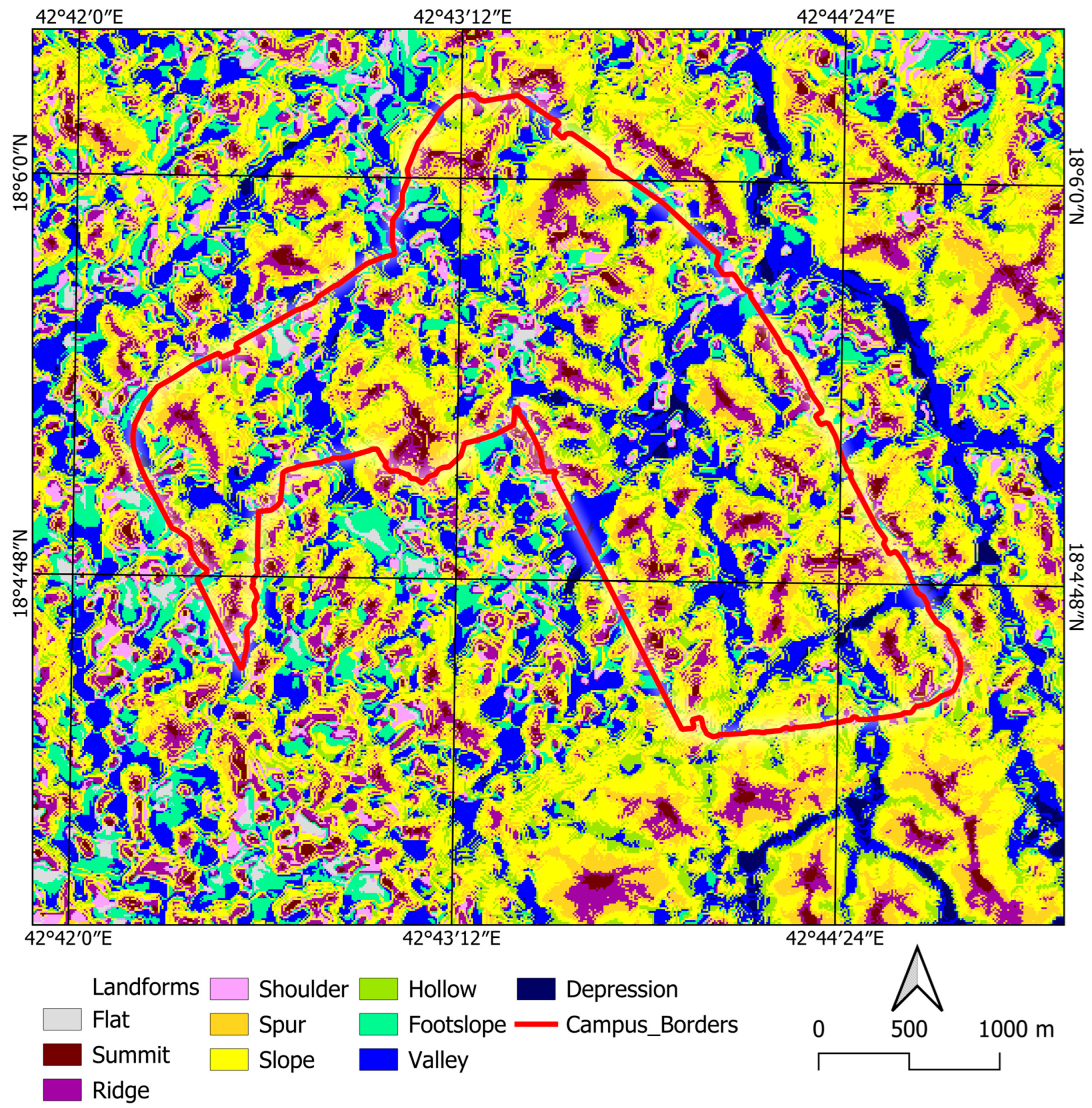
3.2. Results of Landform Mapping
3.3. Results of Hydrological Settings Mapping
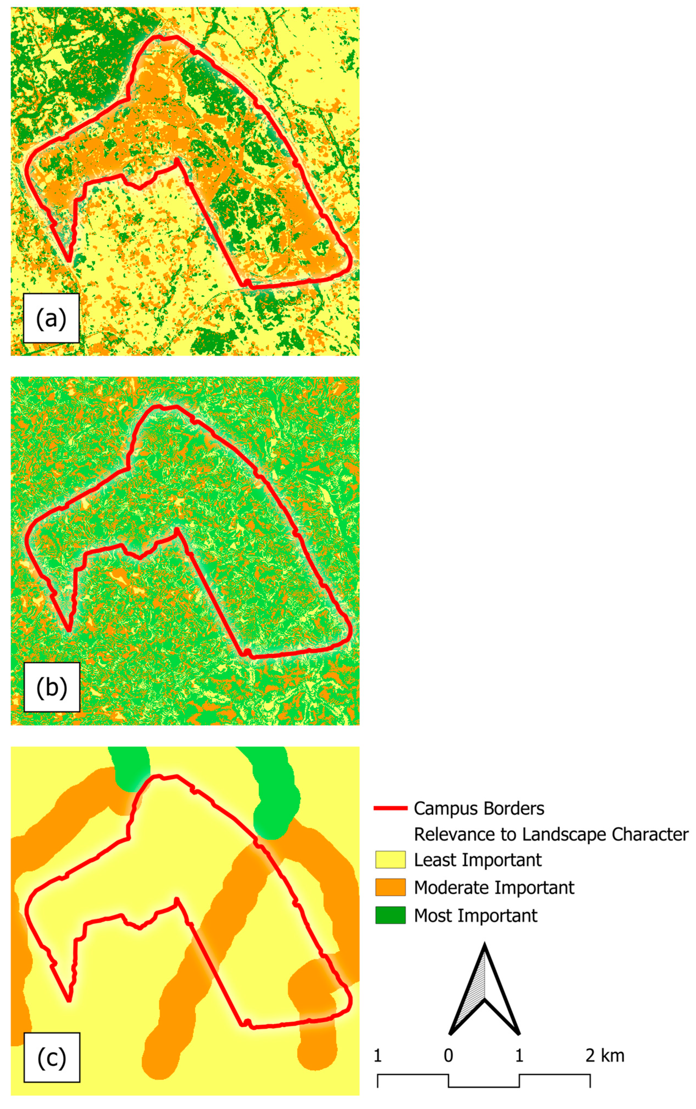
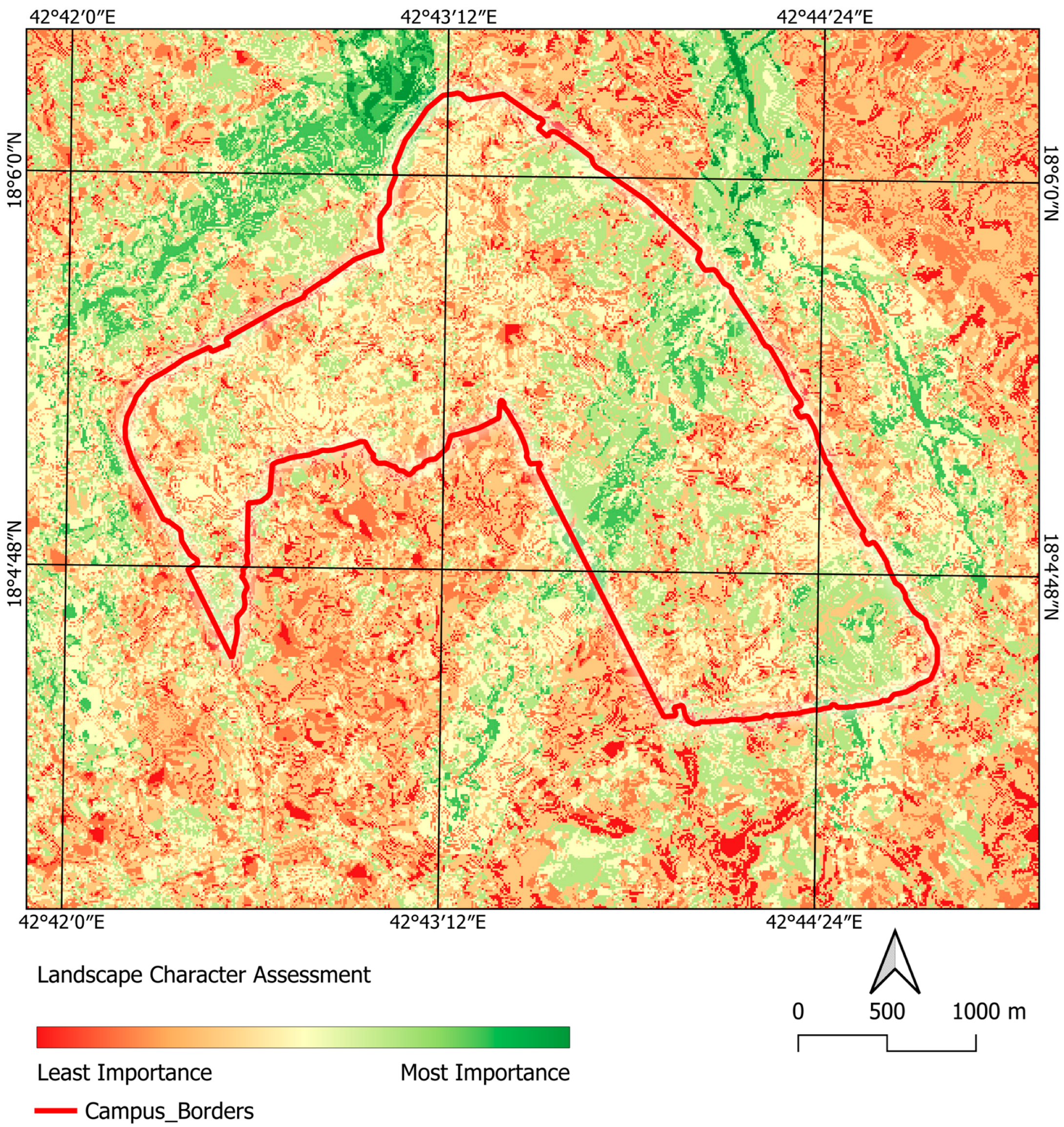
3.4. Results of Mapping and Evaluating Landscape Characters
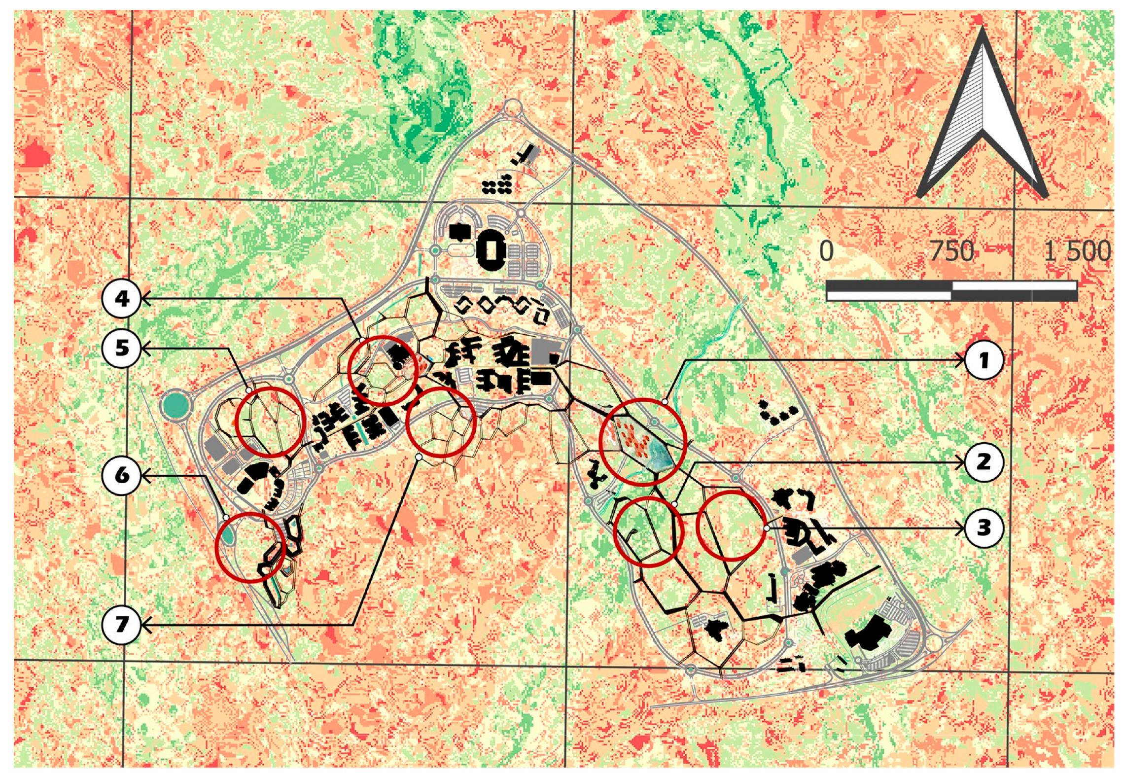
3.5. KUU Landscape Master Plan
- Zone 01: It comprises a central plaza, event space, and food and beverage buildings and creates a vibrant social and cultural hub for the wide university campus. It was intentionally designed in a flat terrain with high visibility from the surrounding landscape. This area allows for flexible open space, accessibility, and visual connection to the rocky backdrop. In the central plaza, a retention water pond is integrated along the natural water collection corridor, in alignment with the hydrological setting map, which acts as an aesthetic and sustainable drainage feature.
- Zone 02: The camping site is located on a mountainous topography in the high landscape character value zone that features steep landforms and dense vegetation. This increases privacy for the camping units and maintains their natural setting and intriguing landscape features.
- Zone 03: The orchard park is strategically situated in the rocky landscape zone, identified as a high-value area according to the LCA results map. This setting is distinguished by a rugged formation, scattered native vegetation, and visual drama, making the park a place to relax, exercise, and socialize.
- Zone 04: This zone comprises the botanical garden and the library plaza and resembles Zone 01 in terms of the flat terrain setting and the high visibility from surrounding buildings and hills. It is easily accessed from surrounding buildings and the main pedestrian route.
- Zone 05: According to the LCA, this mountainous zone achieves a high level of importance due to its physical dominance, landmark quality, and visual connectivity across the wide landscape. It sits at the main gateway to the campus, featuring a welcoming landscape and strong identity. Hence, it was occupied by the observation platform that can provide an expansive 360° panoramic view of the campus and the surrounding landscape.
- Zone 06: In accordance with the LCA results, the investment zone is recognized as an area with a high level of landscape importance and accommodates the investment architecture of commerce, offices, and hotels. It occupies a flat terrain that is suitable for construction and is integrated with the nearby rocky hill.
4. Discussion
5. Conclusions
Supplementary Materials
Author Contributions
Funding
Data Availability Statement
Conflicts of Interest
References
- Vogiatzakis, I.N. Mediterranean experience and practice in Landscape Character Assessment. Eight Const. Med. 2011, 37, 17–31. [Google Scholar] [CrossRef]
- Griffiths, G. Transferring Landscape Character Assessment from the UK to the Eastern Mediterranean: Challenges and Perspectives. Land 2018, 7, 36. [Google Scholar] [CrossRef]
- Gülçin, D.; Yılmaz, K.T. Mapping Landscape Potential for Supporting Green Infrastructure: The Case of a Watershed in Turkey. Land 2020, 9, 268. [Google Scholar] [CrossRef]
- Butler, A. Dynamics of Integrating Landscape Values in Landscape Character Assessment: The Hidden Dominance of the Objective Outsider. Landsc. Res. 2016, 41, 239–252. [Google Scholar] [CrossRef]
- Butler, A. Routledge Handbook of Landscape Character Assessment: Edited by Graham Fairclough, Ingrid Sarlöv-Herlin and Carys Swanwick, Abingdon, Routledge, 2018, 249 pp., £175.00 Hardback, £70.00 Ebook, ISBN 9781138803886. Landsc. Res. 2020, 45, 392–393. [Google Scholar] [CrossRef]
- Palmer, J.F.; Smardon, R.C. US approaches related to Landscape Character Assessment. In Routledge Handbook of Landscape Character Assessment; Fairclough, G., Herlin, I.S., Swanwick, C., Eds.; Routledge: Abingdon, UK; New York, NY, USA, 2018; pp. 131–142. ISBN 978-1-315-75342-3. [Google Scholar]
- Jellema, A.; Stobbelaar, D.-J.; Groot, J.C.J.; Rossing, W.A.H. Landscape Character Assessment Using Region Growing Techniques in Geographical Information Systems. J. Environ. Manag. 2009, 90, S161–S174. [Google Scholar] [CrossRef]
- Martín, B.; Ortega, E.; Otero, I.; Arce, R.M. Landscape Character Assessment with GIS Using Map-Based Indicators and Photographs in the Relationship between Landscape and Roads. J. Environ. Manag. 2016, 180, 324–334. [Google Scholar] [CrossRef]
- Moreno-de Las Heras, M.; Saco, P.M.; Willgoose, G.R.; Tongway, D.J. Assessing Landscape Structure and Pattern Fragmentation in Semiarid Ecosystems Using Patch-Size Distributions. Ecol. Appl. 2011, 21, 2793–2805. [Google Scholar] [CrossRef]
- Abolhasani, A.; Zehtabian, G.; Khosravi, H.; Rahmati, O.; Alamdarloo, E.H.; D’Odorico, P. A New Conceptual Framework for Spatial Predictive Modelling of Land Degradation in a Semiarid Area. Land. Degrad. Dev. 2022, 33, 3358–3374. [Google Scholar] [CrossRef]
- Bourgeron, P.S.; Humphries, H.C.; Jensen, M.E. Landscape Characterization: A Framework for Ecological Assessment at Regional and Local Scales. J. Sustain. For. 1994, 2, 267–281. [Google Scholar] [CrossRef]
- Almalki, R.; Khaki, M.; Saco, P.M.; Rodriguez, J.F. Monitoring and Mapping Vegetation Cover Changes in Arid and Semi-Arid Areas Using Remote Sensing Technology: A Review. Remote Sens. 2022, 14, 5143. [Google Scholar] [CrossRef]
- Terkenli, T.; Gkoltsiou, A.; Kavroudakis, D. The Interplay of Objectivity and Subjectivity in Landscape Character Assessment: Qualitative and Quantitative Approaches and Challenges. Land 2021, 10, 53. [Google Scholar] [CrossRef]
- Bagheri Bodaghabadi, M.; Martínez-Casasnovas, J.A.; Khakili, P.; Masihabadi, M.H.; Gandomkar, A. Assessment of the FAO Traditional Land Evaluation Methods, A Case Study: Iranian Land Classification Method. Soil. Use Manag. 2015, 31, 384–396. [Google Scholar] [CrossRef]
- Costanza, J.K.; Riitters, K.; Vogt, P.; Wickham, J. Describing and Analyzing Landscape Patterns: Where Are We Now, and Where Are We Going? Landsc. Ecol. 2019, 34, 2049–2055. [Google Scholar] [CrossRef]
- Sowińska-Świerkosz, B.; Michalik-Śnieżek, M. Landscape Indicators as a Tool of Assessing Landscape Quality. E3S Web Conf. 2020, 171, 02011. [Google Scholar] [CrossRef]
- Hill, M.J.; Braaten, R.; Veitch, S.M.; Lees, B.G.; Sharma, S. Multi-Criteria Decision Analysis in Spatial Decision Support: The ASSESS Analytic Hierarchy Process and the Role of Quantitative Methods and Spatially Explicit Analysis. Environ. Model. Softw. 2005, 20, 955–976. [Google Scholar] [CrossRef]
- Wróżyński, R.; Pyszny, K.; Sojka, M. Quantitative Landscape Assessment Using LiDAR and Rendered 360° Panoramic Images. Remote Sens. 2020, 12, 386. [Google Scholar] [CrossRef]
- Wartmann, F.M.; Mackaness, W.A.; Bauer, N.; Bolliger, J.; Kienast, F. Towards an Interdisciplinary Understanding of Landscape Qualities: Wilderness, Tranquillity and Dark Skies. In Current Trends in Landscape Research; Mueller, L., Eulenstein, F., Eds.; Innovations in Landscape Research; Springer International Publishing: Cham, Switzerland, 2019; pp. 191–220. ISBN 978-3-030-30068-5. [Google Scholar]
- Mansori, M.; Badehian, Z.; Ghobadi, M.; Maleknia, R. Assessing the Environmental Destruction in Forest Ecosystems Using Landscape Metrics and Spatial Analysis. Sci. Rep. 2023, 13, 15165. [Google Scholar] [CrossRef] [PubMed]
- Chang, K. Introduction to Geographic Information Systems, 9th ed.; McGraw-Hill Education: New York, NY, USA, 2019; ISBN 978-1-260-09258-5. [Google Scholar]
- Baude, M.; Meyer, B.C. Changes in Landscape Structure and Ecosystem Services since 1850 Analyzed Using Landscape Metrics in Two German Municipalities. Ecol. Indic. 2023, 152, 110365. [Google Scholar] [CrossRef]
- Bhermana, A.; Suparman, S.; Tunisa, H.; Hendro Sunarminto, B. Identification of Land Resource Potential for Agricultural Landscape Planning Using Land Capability Evaluation Approach and GIS Application (a Case in Central Kalimantan Province, Indonesia). J. Lahan Suboptimal 2021, 10, 170–177. [Google Scholar] [CrossRef]
- Buczyńska, A. Remote Sensing and GIS Technologies in Land Reclamation and Landscape Planning Processes on Post-Mining Areas in the Polish and World Literature. AIP Conf. Proc. 2020, 2209, 040002. [Google Scholar] [CrossRef]
- Mat Isa, M.; Ismail, N.A.; Abdul Rasam, A.R.; Teh, M.Z. Landscape Characterization Using GIS-Based Landscape Character Assessment in Hulu Langat District, Malaysia. Geografia 2023, 19, 17–33. [Google Scholar] [CrossRef]
- Menasra, A.; Bouzaher, S. GIS Tools for Landscape Character Assessment: Case of Ziban Region in Algeria. Geomat. Landmanagement Landsc. 2021, 4, 19–29. [Google Scholar] [CrossRef]
- Pan, Y.; Wu, Y.; Xu, X.; Zhang, B.; Li, W. Identifying Terrestrial Landscape Character Types in China. Land 2022, 11, 1014. [Google Scholar] [CrossRef]
- Zhao, Y.; Harvey, D.C.; Gao, C. Identifying Shan-Shui Characteristics for National Landscape Heritage: Reconciling Western and Chinese Landscape Characterisation from a Trans-Cultural Perspective. Geogr. J. 2020, 186, 300–313. [Google Scholar] [CrossRef]
- Karasov, O.; Vieira, A.A.B.; Külvik, M.; Chervanyov, I. Landscape Coherence Revisited: GIS-Based Mapping in Relation to Scenic Values and Preferences Estimated with Geolocated Social Media Data. Ecol. Indic. 2020, 111, 105973. [Google Scholar] [CrossRef]
- Chang Chien, Y.-M.; Carver, S.; Comber, A. An Exploratory Analysis of Expert and Nonexpert-Based Land-Scape Aesthetics Evaluations: A Case Study from Wales. Land 2021, 10, 192. [Google Scholar] [CrossRef]
- Eben Saleh, M.A. Value Assessment of Cultural Landscape in Alckas Settlement, Southwestern Saudi Arabia. AMBIO A J. Hum. Environ. 2000, 29, 60–66. [Google Scholar] [CrossRef]
- Addas, A. Landscape Architecture and The Saudi Arabia Quality of Life Program. Emir. J. Eng. Res. 2018, 24, 2. [Google Scholar]
- Alharbi, O.A.; Rangel-Buitrago, N. Landscape Degradation in the Jazan Coastal Desert: Understanding the Impact of Human Activities. Mar. Pollut. Bull. 2023, 190, 114874. [Google Scholar] [CrossRef]
- Nijhuis, S. Applications of GIS in Landscape Design Research. Res. Urban. Ser. 2016, 4, 43–56. [Google Scholar] [CrossRef]
- Adkar, N.; Rajput, B.; Devi, T.O.; Tarawade, S.; Jindam, D. Verifying the Underutilizationof Geographic Information Systems (GIS) in the Realm of Landscape Architecture and Planning. In Proceedings of the 2020 Advances in Science and Engineering Technology International Conferences (ASET), Dubai, United Arab Emirates, 20–23 February 2020; IEEE: Dubai, United Arab Emirates, 2020; pp. 1–6. [Google Scholar]
- Kempa, D.; Lovett, A.A. Using GIS in Landscape Planning. In Landscape Planning with Ecosystem Services; Von Haaren, C., Lovett, A.A., Albert, C., Eds.; Landscape Series; Springer: Dordrecht, The Netherlands, 2019; Volume 24, pp. 77–88. ISBN 978-94-024-1679-4. [Google Scholar]
- Reljić, D.T.; Koscak, V.; Butula, S.; Andlar, G. An Overview of GIS Applications in Landscape Planning. Kartogr. I Geoinformacije 2017, 16, 26–43. [Google Scholar]
- Ahmed, B. Climate of the Kingdom of Saudi Arabia; Kuwait University: Kuwait City, Kuwait, 1993. [Google Scholar]
- Mohammed, W.E.; Algarni, S. A Remote Sensing Study of Spatiotemporal Variations in Drought Conditions in Northern Asir, Saudi Arabia. Environ. Monit. Assess. 2020, 192, 784. [Google Scholar] [CrossRef]
- Delwart, S. Sentinel-2 User Handbook; European Space Agency (ESA): Paris, France, 2015; p. 64. [Google Scholar]
- Mahato, R.; Nimasow, G. Morphometric Analysis of Bichom River Basin, Arunachal Pradesh, India Using ALOS PALSAR RTC DEM and Geospatial Technology. Appl. Geomat. 2023, 15, 853–870. [Google Scholar] [CrossRef]
- Liu, X.; Zhao, C.; Zhang, Q.; Lu, Z.; Li, Z.; Yang, C.; Zhu, W.; Liu-Zeng, J.; Chen, L.; Liu, C. Integration of Sentinel-1 and ALOS/PALSAR-2 SAR Datasets for Mapping Active Landslides Along the Jinsha River Corridor, China. Eng. Geol. 2021, 284, 106033. [Google Scholar] [CrossRef]
- Alves, M.L.P.R.; Oliveira, R.G.L.; Rocha, C.A.A.; Filgueira, H.J.A.; Da Silva, R.M.; Santos, C.A.G. Assessing Flood Susceptibility with ALOS PALSAR and LiDAR Digital Terrain Models Using the Height Above Nearest Drainage (HAND) Model. Environ. Dev. Sustain. 2024. [Google Scholar] [CrossRef]
- Wang, X.; Honda, H.; Djamaluddin, I.; Taniguchi, H.; Mitani, Y. Quantitatively Detecting Ground Surface Changes of Slope Failure Caused by Heavy Rain Using ALOS-2/PALSAR-2 Data: A Case Study in Japan. Sci. Rep. 2024, 14, 23110. [Google Scholar] [CrossRef]
- Saraf, A.K.; Choudhury, P.R.; Roy, B.; Sarma, B.; Vijay, S.; Choudhury, S. GIS Based Surface Hydrological Modelling in Identification of Groundwater Recharge Zones. Int. J. Remote Sens. 2004, 25, 5759–5770. [Google Scholar] [CrossRef]
- Bartlett, D.; Milliken, S. Landscape Character and Ecosystem Services Assessment: A Case Study from India. In Current Trends in Landscape Research; Mueller, L., Eulenstein, F., Eds.; Innovations in Landscape Research; Springer International Publishing: Cham, Switzerland, 2019; pp. 521–543. ISBN 978-3-030-30068-5. [Google Scholar]
- Rosas-Chavoya, M.; Gallardo-Salazar, J.L.; López-Serrano, P.M.; Alcántara-Concepción, P.C.; León-Miranda, A.K. QGIS a Constantly Growing Free and Open-Source Geospatial Software Contributing to Scientific Development. Cuad. Investig. Geogr. 2022, 48, 197–213. [Google Scholar] [CrossRef]
- Conrad, O.; Bechtel, B.; Bock, M.; Dietrich, H.; Fischer, E.; Gerlitz, L.; Wehberg, J.; Wichmann, V.; Böhner, J. System for Automated Geoscientific Analyses (SAGA) v. 2.1.4. Geosci. Model Dev. 2015, 8, 1991–2007. [Google Scholar] [CrossRef]
- Phiri, D.; Simwanda, M.; Salekin, S.; Nyirenda, V.; Murayama, Y.; Ranagalage, M. Sentinel-2 Data for Land Cover/Use Mapping: A Review. Remote Sens. 2020, 12, 2291. [Google Scholar] [CrossRef]
- Pessiot, L. Sentinel-2 Products Specification Document; European Space Agency (ESA): Paris, France, 2024. [Google Scholar]
- Chavez, P.S. Image-Based Atmospheric Corrections—Revisited and Improved. Photogramm. Eng. Remote Sens. 1996, 62, 1025–1036. [Google Scholar]
- Santosa, P.B. Evaluation of Satellite Image Correction Methods Caused by Differential Terrain Illumination. Forum Geogr. 2016, 30, 1. [Google Scholar] [CrossRef]
- Chuvieco, E. Fundamentals of Satellite Remote Sensing: An Environmental Approach, 3rd ed.; CRC Press: Boca Raton, FL, USA; London, UK; New York, NY, USA, 2023; ISBN 978-1-032-65444-7. [Google Scholar]
- Jasiewicz, J.; Stepinski, T.F. Geomorphons—A Pattern Recognition Approach to Classification and Mapping of Landforms. Geomorphology 2013, 182, 147–156. [Google Scholar] [CrossRef]
- Luo, W.; Liu, C.-C. Innovative Landslide Susceptibility Mapping Supported by Geomorphon and Geographical Detector Methods. Landslides 2018, 15, 465–474. [Google Scholar] [CrossRef]
- Flynn, T.; Rozanov, A.; Ellis, F.; De Clercq, W.; Clarke, C. Farm-Scale Soil Patterns Derived from Automated Terrain Classification. Catena 2020, 185, 104311. [Google Scholar] [CrossRef]
- O’Callaghan, J.F.; Mark, D.M. The Extraction of Drainage Networks from Digital Elevation Data. Comput. Vision. Graph. Image Process. 1984, 28, 323–344. [Google Scholar] [CrossRef]
- Tara, A.; Lawson, G.; Davies, W.; Chenoweth, A.; Pratten, G. Integrating Landscape Character Assessment with Community Values in a Scenic Evaluation Methodology for Regional Landscape Planning. Land 2024, 13, 169. [Google Scholar] [CrossRef]
- O’Neill, R.V.; Hunsaker, C.T.; Jones, K.B.; Riitters, K.H.; Wickham, J.D.; Schwartz, P.M.; Goodman, I.A.; Jackson, B.L.; Baillargeon, W.S. Monitoring Environmental Quality at the Landscape Scale. BioScience 1997, 47, 513–519. [Google Scholar] [CrossRef]
- Sohel, M.S.I.; Ahmed Mukul, S.; Burkhard, B. Landscape׳s Capacities to Supply Ecosystem Services in Bangladesh: A Mapping Assessment for Lawachara National Park. Ecosyst. Serv. 2015, 12, 128–135. [Google Scholar] [CrossRef]
- Florinsky, I.V.; Kulagina, T.B.; Meshalkina, J.L. Influence of Topography on Landscape Radiation Temperature Distribution. Int. J. Remote Sens. 1994, 15, 3147–3153. [Google Scholar] [CrossRef]
- Sofia, G.; Tarolli, P. Hydrological Response to ~30 years of Agricultural Surface Water Management. Land 2017, 6, 3. [Google Scholar] [CrossRef]
- Morgan, M. Power, Culture, and Materiality in Modernity. Cult. Sociol. 2022, 16, 112–117. [Google Scholar] [CrossRef]
- Amoroso, N. Representing Landscapes: A Visual Collection of Landscape Architectural Drawings; Taylor & Francis Group: London, UK; New York, NY, USA, 2012; ISBN 978-0-415-58956-7. [Google Scholar]


| Class | Description |
|---|---|
| Asphalt | any area covered with asphalt that facilitates the transportation of vehicles and individuals. |
| Domestic vegetation | any area where cultivated plants cover at least 50% of the area, particularly in urban contexts. |
| Undeveloped | any area that remains undisturbed and pristine, characterized by minimal human interference. |
| Natural vegetation | any area where vegetation growth takes place independently of human influence or agricultural practices. |
| Rock land | any area characterized by a predominance of exposed rock surfaces, boulders, or rocky outcrops, exhibiting minimal soil cover and a lack of vegetation. |
| Built-up | any area that has undergone significant development or alteration due to human activities, characterized primarily by the presence of structures, infrastructure, and impervious surfaces. |
| Significance | Weight | LU\LC | Landform | Channel |
|---|---|---|---|---|
| Most important | 3 | Natural vegetation | ridges | 4th Order |
| Rocky land | summits | |||
| valleys | ||||
| slopes | ||||
| Moderate important | 2 | Domestic vegetation | Spurs | 3rd Order |
| Built-up | shoulders | |||
| Foot-slopes | ||||
| Least important | 1 | Undeveloped | Flats | 2nd Order |
| Asphalt | Depressions | 1st Order | ||
| Hollows |
Disclaimer/Publisher’s Note: The statements, opinions and data contained in all publications are solely those of the individual author(s) and contributor(s) and not of MDPI and/or the editor(s). MDPI and/or the editor(s) disclaim responsibility for any injury to people or property resulting from any ideas, methods, instructions or products referred to in the content. |
© 2025 by the authors. Licensee MDPI, Basel, Switzerland. This article is an open access article distributed under the terms and conditions of the Creative Commons Attribution (CC BY) license (https://creativecommons.org/licenses/by/4.0/).
Share and Cite
Mohammed, W.E.; Mohammad, O.H.; Alabdulla, M.M. GIS-Based Landscape Character Assessment as a Tool for Landscape Architecture Design: A Case Study from Saudi Arabia. Land 2025, 14, 2173. https://doi.org/10.3390/land14112173
Mohammed WE, Mohammad OH, Alabdulla MM. GIS-Based Landscape Character Assessment as a Tool for Landscape Architecture Design: A Case Study from Saudi Arabia. Land. 2025; 14(11):2173. https://doi.org/10.3390/land14112173
Chicago/Turabian StyleMohammed, Wisam E., Omar H. Mohammad, and Montasir M. Alabdulla. 2025. "GIS-Based Landscape Character Assessment as a Tool for Landscape Architecture Design: A Case Study from Saudi Arabia" Land 14, no. 11: 2173. https://doi.org/10.3390/land14112173
APA StyleMohammed, W. E., Mohammad, O. H., & Alabdulla, M. M. (2025). GIS-Based Landscape Character Assessment as a Tool for Landscape Architecture Design: A Case Study from Saudi Arabia. Land, 14(11), 2173. https://doi.org/10.3390/land14112173


