Article

Open Spaces in the European Alps—GIS-Based Analysis and Implications for Spatial Planning from a Transnational Perspective

1
Chair of Geography and Regional Science, Julius-Maximilians-University Würzburg, 97074 Wurzburg, Germany
2
Academy for Territorial Development in the Leibniz Association (ARL), 30179 Hannover, Germany
3
ALPARC—The Alpine Network of Protected Areas, 73000 Chambery, France
4
Urban Planning Institute of the Republic of Slovenia (UIRS), 1000 Ljubljana, Slovenia
5
Eurac Research, Institute for Regional Development, 39100 Bolzano, Italy
6
Salzburg Institute for Regional Planning and Housing (SIR), 5020 Salzburg, Austria
7
Research Unit Land Policy and Land Management, TU Wien, 1040 Vienna, Austria
*
Author to whom correspondence should be addressed.
Land 2022, 11(9), 1605; https://doi.org/10.3390/land11091605
Submission received: 11 August 2022 / Revised: 10 September 2022 / Accepted: 12 September 2022 / Published: 19 September 2022

Abstract

:
This article presents an open space concept of areas that are kept permanently free from buildings, technical infrastructure, and soil sealing. In the European Alps, space is scarce because of the topography; conflicts often arise between competing land uses such as permanent settlements and commercial activity. However, the presence of open spaces is important for carbon sequestration and the prevention of natural hazards, especially given climate change. A GIS-based analysis was conducted to identify an alpine-wide inventory of large-scale near-natural areas, or simply stated, open spaces. The method used identified the degree of infrastructure development for natural landscape units. Within the Alpine Convention perimeter, near-natural areas (with a degree of infrastructural development of up to 20%) account for a share of 51.5%. Only 14.5% of those areas are highly protected and are mostly located in high altitudes of over 1500 m or 2000 m above sea level. We advocate that the remaining Alpine open spaces must be preserved through the delimitation of more effective protection mechanisms, and green corridors should be safeguarded through spatial planning. To enhance the ecological connectivity of open spaces, there is the need for tailored spatial and sectoral planning strategies to prevent further landscape fragmentation and to coordinate new forms of land use for renewable energy production.

1. Introduction

In Central Europe, open spaces are continuously being transformed into settlement areas and used for technical infrastructure, causing ongoing soil sealing [1,2,3]. The primary consequence is a loss of agricultural land. In addition, the landscape is being fragmented because of urban sprawl, leading to natural habitat isolation and the deterioration of ecological connectivity, and ultimately causing biodiversity loss [4]. Yet why should we care about the Alps, as it is the least populated and economically significant area in Central Europe? In the Alpine region, spatial planning is needed to safeguard open spaces for the following reasons:
First, the relative speed of temperature increases as a result of climate change is faster than the European average [5,6,7]. This impacts the energy transition role of the Alps [8] and its ability to supply (drinking) water to extra-alpine areas [9]. Second, the alpine ecosystems and the population face numerous geohazards because of the terrain– increased extreme events due to severe gravitational processes through more relief energy, and flooding risks in narrow valleys [10,11,12,13]. The Alpine region, therefore, has the potential to serve as a pioneer in risk prevention spatial planning, which might be more common in the future and might also apply to the lowlands or pre-alpine areas. Third, the alpine topography has little potential for permanent settlements leading to numerous land use conflicts [14,15,16,17]. Hence, the Alps can be seen as a “burning glass” concerning the need for sustainable settlement development and limiting land take, proving important lessons for spatial planning in other (central) European regions.
The Alps are not a homogeneous area. Two opposing trends can be observed in its territorial development: While peripheral areas are partly characterized by population decline, and abandonment of agricultural land uses (e.g., in mountain areas of Friuli-Venezia-Giulia, Italy), processes of urbanization and urban sprawl often dominate the valleys (such as, e.g., in the Austrian Inn valley) [18]. The latter trend is accompanied by a loss of limited agricultural land. In certain Alpine areas, there is an ongoing development of technical infrastructure for recreational purposes and ski resorts in high mountain areas [19]. “Hybrid” forms of accommodation (e.g., chalet villages, resorts, apartment buildings, etc.) are appearing alongside “classic” land requirements such as tourist infrastructure, accommodation, and locally induced settlement development. In some regions of the Alps, second homes are a significant factor in the building land demand [20]. Tourism structures in the Alps are unevenly distributed and typically have significant seasonality. The combination of climate change and competition in the limited permanent settlement space [21] highlights the need for supra-local management of tourism development by spatial planning [22].
The project “ALPBIONET2030” has identified strategically important areas (transnational/-regional corridors and barriers) for the preservation of ecological connectivity in the EUSALP1 Alpine macro-region, called Strategic Alpine Connectivity Areas (SACA) [23]. In this respect, spatial planning has an important role to play in ensuring structural and functional ecological connectivity in terms of coherent Green Infrastructure (GI) planning. Climate change must be considered in several respects, e.g., it will lead to a shift in the distribution range of threatened species so that their focal points may no longer lie within existing protected areas [24]. Furthermore, it increases the risk of natural hazards, such as landslides, rockfalls, or flooding [11,25,26]. Hence, it is obvious that spatial planning for open spaces at the local level solely within the framework of municipal land use planning cannot be sufficient. Knowing that the challenges faced in the Alps are often cross-border in nature and can best be solved through cooperation, the Alpine countries, together with the European Union, signed the Alpine Convention in 1991. This pioneering convention was the first legally binding international treaty that aimed to sustainably develop and protect an entire mountain range. It also features several legally binding (implementation) protocols, which set various requirements for the preservation of open spaces as a mandate for spatial planning and nature conservation in the alpine countries.
Overall, three research questions needed to be answered in this article: Why is it necessary to safeguard open spaces in the Alpine region? Which open spaces still exist in the Alps, and how can they be identified? How can they be further safeguarded using spatial and sectoral planning? The paper first introduces the open space concept from a spatial planning viewpoint and discusses the state of the art of research on the detection and analysis of alpine open spaces. Subsequently, the methodological approach of the paper is presented. A GIS-based cartographic analysis was executed, which identified the degree of infrastructure development of hydro-geographically delimited spatial landscape units. In Section 3, the main challenges were identified, followed by a discussion of the approach and potential steering mechanisms and the last section presents urgent tasks regarding spatial or sectoral planning.

2. Materials and Methods

2.1. Detecting Alpine Open Spaces—State of the Art

Before discussing spatial planning issues, we present an overview of recent state-of-the-art research that analyses open spaces in the Alps (see Table 1). The research works described were all conducted using Geographic Information Systems (GIS) and quantitative research methods that build on each other methodologically. Chronologically they form a sequence and are presented starting with a regional pilot study (Vorarlberg), then a profound national work (Switzerland), and finally an ambitioned analysis for the macro-regional EUSALP area, which was politically delimited by the EU. In terms of the data basis on infrastructure, challenges of compatible parameters arise as the study area gets larger. The issue of spatial units leads to another problem: the reliability of the demarcation of watershed units. Based on the fact that the analysis from ALPARC 2021 [27] on the EUSALP perimeter used watershed basins with a too coarse resolution, a subsequent analysis in this article was performed, focusing on the Alpine Convention perimeters as the core area of high mountains, deep valleys inside the Alps, and their foreland.
Empirical evidence obtained by Kopf et al. (2017) [28] shows that only 6% of Vorarlberg’s area is undeveloped, with negligible infrastructure rates ranging from 0–5%. Landscape “chambers” are delimited with less than 20% infrastructural development. These “white zones” account for 19% of the territory. More than three-quarters of those are at high altitudes (the mean elevation of white zones is 1942 m above sea level), 28% are used for Alpine meadows, and over 50% are barren Alpine land. The potential for valuable landscapes worthy of protection is especially high in white zones: 50% of white zones are officially designated as valuable biotopes (without protection status). However, protected areas only account for about 30% [28].
In Switzerland, Nischik and Pütz (2018) [29] identify 32.5% of the territory as “semi-natural open spaces” (defined by a degree of infrastructure development between 0% and 20%), with a mean size of 4.7 km2. Only a small number of the identified semi-natural open spaces are at low altitudes, usually in valleys: 12.7% are located between the altitudes of 1000 m and 1500 m above sea level. Only 2.5% are below 1000 m above sea level, and a negligible 0.2% can be found below 500 m above sea level. These low-lying areas are usually flat and covered by soil that can be cultivated. In contrast, many of the detected semi-natural open spaces are at high altitudes and characterized by steep slopes, vegetation-free, or glaciated terrain. The largest semi-natural open space in Switzerland covers an area of 122 km2. This is the water catchment area of the Great Aletsch Glacier, the largest and longest glacier in the Alps. Furthermore, the analysis shows that only around 47% of all identified semi-natural open spaces fall under nationally protected areas, mainly located at high altitudes of around 2000 m above sea level.
Coronado and Plassmann (ALPARC 2021) [27] also delimitate “near-natural open spaces” with a spatial development of up to 20%. On the scale of the EUSALP macro-region, this represents only 29% of the area. In contrast, the Alpine Convention perimeter covers 55% of spaces featuring infrastructure development of up to 20%. When excluding the areas inside the Alpine Convention perimeter, this proportion decreases to 6%. Nearly all spaces with infrastructure development of under 10% in the EUSALP are concentrated inside the Alpine Convention perimeter, resulting in 31% of the surface of the Alpine Convention. This indicates the huge importance of the Alpine arc as a retreat area for biodiversity. Near-natural open spaces are mostly covered by bare rocks (47%), sparsely vegetated areas (45%), glaciers, and perpetual snow (8%)2.
Furthermore, on average, 80% of the “SACA 1”3 area is covered by the near-natural open spaces. The already mentioned SACA overlay of near-natural open spaces [23] determines the connectivity potential of a given area. Scholars show that the ecological connectivity function is fully achieved in the intersected areas when the infrastructure presence is low, and the Continuum Suitability Index (CSI—a combined parameter of structural landscape connectivity and landscape permeability) [31] has a higher value. Therefore, the locations identified might be prioritized for ecological connectivity, conservation, and restoration.
Starting from the work of ALPARC 2021 [27], a more detailed GIS analysis was conducted in this article. This included focusing on the smaller perimeter of the Alpine convention—because the Alpine arc is a biodiversity sanctuary–and choosing a finer resolution, using hydrological basins from EU-HYDRO [32] with a mean size of 22.5 km2 (in the Alpine Convention perimeter). In doing so, we differentiated the immaculate (“pure”) open spaces in the absence of any considered development or infrastructure (as well as buffers, quasi-executing an explicit “binary” approach). We were also able to identify ‘near-natural open spaces’ with a degree of infrastructure development— larger than 0.1% and up to 20%—largely free of heavy anthropogenic development.
Next, we present our definition of the open space concept and explain the methods applied to analyzing Alpine open spaces.

2.2. Definitions

The term open space has not been clearly and conclusively defined by scholars. So far, there is no consistent understanding among the alpine countries, especially with Alpine languages providing different notions of the concept. The understanding discussed here is mainly led by past and present academic and professional discussions in Germany, Austria, and Switzerland (DE: Freiraumschutz). Historically, open space was a spatial planning concept that first emerged during the reorientation of spatial planning toward an emerging environmental policy at the beginning of the 1970s [33]. This was because of a general trend in society following the United Nations Conference on the Human Environment in 1972 in Stockholm: the first worldwide political platform to raise the environment as a major issue. This was triggered by the problem of increasing greenfield land take owing to rapid urbanization in European countries. From a landscape ecology perspective, open space is viewed as a part of the landscape not affected by built development or linear infrastructure facilities resembling a built development [34]. Hence, of interest are mostly semi-natural areas with predominantly sustainable uses (e.g., extensive agricultural areas, forests, moors, rivers and lakes, farm tracks, cycle paths, and hiking trails), which might be subject to interactions between natural or anthropogenic factors. They, therefore, consist of both natural areas, almost untouched by humans, and cultural landscapes that have been subject to minor transformations [29].
As mentioned above, open space is not an unambiguous term in itself; it must be carefully used in the respective disciplinary context. In countries such as Germany and Austria, open space is a term anchored in planning and environmental law as well as spatial development strategies. However, in other Alpine countries such as Slovenia or Italy, the term itself is less common or refers only to inner-urban open spaces [22]. As a first basic definition, open space can be considered an area that is free from extensive anthropogenic intervention and thus allows for the area-bound functions of landscapes [35]. Extensive anthropogenic intervention is primarily considered to involve constructive development and soil sealing. Other forms of human land use, e.g., agricultural use, also have a considerable influence on the natural characteristics and ecological processes of an area, but they are generally considered to be compatible with open space. Thus, the concept of open space used for spatial planning is not about the absence of anthropogenic use—in the sense of extreme remoteness and wilderness per se—but about limiting intensive forms of land use associated with the construction of buildings and technical infrastructure [22]. Open spaces within settlement structures (e.g., public parks) are not relevant in this analysis because we argue on a supra-local landscape scale [36].
To comparatively analyze the structure and distribution of open spaces in the Alpine region, we have developed a specific definition following Job et al. [14,36]: “Open spaces comprise areas outside housing/settlement areas, commercial/industrial areas and other specially designated areas (e.g., golf courses and leisure parks) that are kept free from building developments, which are not predominantly developed (punctual, linear or planar infrastructure) and are widely free of soil sealing, ideally free of traffic or largely reserved for non-motorized traffic and thus noise-free. Technical infrastructures not belonging to the landscape structure are either non- or hardly existent.” “Not predominantly developed” ideally means a semi-natural open space completely free of disruptive infrastructure, or at least with only a small proportion of not more than 20% of the space covered with infrastructure development.
The above definition is a negative definition, which uses different exclusion criteria for the delimitation of open spaces. This is mainly for the ease of implementation of criteria sets in a GIS-based model and the better transnational data available for buildings and technical infrastructure (compared with specific features of open/green spaces). However, open spaces should not be understood simply as residual spaces. Building on the approaches of Green Infrastructure (GI) [37,38] and Ecosystem Services (ES) [39,40], open spaces can also be defined in terms of multifold overlapping functions for ecology, economy, and society [22]. The targeted inclusion of the structure, qualities, and functions, as well as the intrinsic value of open spaces into spatial planning, is referred to as open space planning. It can be understood as an integrated component of spatial planning. Open space planning must be guided by specific open space functions. However, certain functions are only effective if the respective areas are spatially and functionally connected to other open spaces, e.g., as a supra-local biotope network [41].

2.3. Data and Methodology

The approach of the GIS analysis is based on the selection of geodata representing building development, soil sealing, and technical infrastructures. The most precise and up-to-date geodata sets for these criteria are usually only available from national or regional authorities. However, these national or regional data often differ in terms of their structure and the definition of infrastructure categories, and not all of them are publicly available for research purposes. To cover all states and regions of the Alps equally, geodata available across Europe are used for the analyses presented, as shown in Table 2. The main data sources are provided by the European Copernicus Land Monitoring Service (LMS): the comparatively coarse-resolution Corine Land Cover 2018 [42] and the high-resolution Impervious Built-up 2018 [43] dataset. However, many linear infrastructure elements (such as roads, cable cars, or power lines) can only be integrated with the freely available data of the OpenStreetMap community. No fundamental guarantee can be given that these OpenStreetMap data are always accurate, comprehensive, and up to date. However, several studies [44,45,46] and our pilot samples in selected alpine regions (comparisons of OpenStreetMap and official geodata for selected infrastructures) suggest that they are suitable for analyses on an alpine-wide scale. Accuracy analysis of used geodata (with specialized remote sensing methods) would go beyond the scope of this article. Suggested reading for evaluation of OpenStreetMap and Copernicus HRL datasets includes, e.g., [47,48]. In the methodology of this paper (aggregated buffers resulting from different infrastructure input datasets), potential accuracy deficits of single datasets are compensated by the mix of several datasets (e.g., the area around buildings/settlements usually also gets buffered/classified as non-open space because of the presence of roads and other linear infrastructure, and vice versa). In some cases, only certain sub-categories (such as cable car types) of the infrastructure layers of OpenStreetMap were extracted to pursue an open space analysis under the presented definition.
Based on the open space definition presented in Section 2.2, corresponding criteria were derived to operationalize the GIS analysis. An area can thus be designated as open space if it is free of built-up areas and technical infrastructure (direct integration of layers representing the corresponding built-up areas and linear (transport) infrastructures) and their disturbance effects (indirect integration by calculating distance buffers). The central criteria for the inclusion of infrastructure layers are that they either directly serve motorized human traffic or the energy supply of human settlements or have a corresponding disturbance effect through noise and pollutant emissions that extend beyond their area. From a conceptual point of view, certain disturbance effects on the respective environments must be assumed for the technical infrastructures under consideration. As these noise and pollutant emissions cannot be individually or realistically modeled for the entire Alpine region, various spatial buffers are modeled as “proxy” assumptions, which differ depending on the specific type of built-up area or infrastructure (cf. Table 2). In the GIS analysis, the resulting open space area is obtained by subtracting (in GIS terms: erasing) the built-up and infrastructure layers and their buffer areas. The first step of the analysis is a “binary” consideration, the result of which distinguishes between open space and non-open space (cf. Figure 1) and is the basis for the further steps of the analysis. In the second step, the specific level of infrastructure development is then calculated for each natural landscape unit (hydro-geographical basins: landscape “chambers”). In the maps and figures of this article, the entire range of infrastructure development is displayed while setting a maximum threshold of 20% for the identification of near-natural areas to produce an analysis that is comparable to previous studies that are mentioned in Table 1 and that use the same threshold. The level of infrastructure development is calculated as follows, with a resulting value between 0 and 100 percent:
L e v e l   o f   i n f r a s t r u c t u r e   d e v e l o p m e n t   ( % ) = m e r g e d   a r e a   o f   b u i l d i n g   &   i n f r a s t r u c t u r e   l a y e r s   &   b u f f e r s   t o t a l   a r e a   o f   t h e   n a t u r a l   l a n d s c a p e   u n i t × 100 %
The geodata of the natural landscape units is taken from the Copernicus LMS “imagery and reference data” section. Within the EU-Hydro dataset, Copernicus LMS offers a drainage model (also called Drainage Network), derived from EU-DEM (digital elevation model), with catchments and drainage lines and nodes [32]. From this dataset, the basic units of “basins” are incorporated, which feature a mean size of 22.5 km2 within the Alpine Convention perimeter. Before processing the basins, lakes were extracted, using the “inland water” layer as well from the EU-hydro river network. After calculating the level of infrastructure development for every natural landscape unit, statistical summaries are created for different political (Alpine Convention perimeter and EUSALP macro-region) and administrative territories (countries), the results of which are presented in Section 3. It is important to mention that when overlaying the perimeters, the natural landscape units are not cut off at the respective administrative boundary (only for cartographic purposes). Still, all landscape units are statistically included that are completely or partially located in the respective perimeter. The EUDEM v.1.1 digital elevation model [49] from the Copernicus Land Monitoring Service with a spatial resolution of 25 m is used for the overlay and analysis of the elevation levels. For the respective zonal statistics, mean values of the raster cells of the DEM in the GIS are generated.
To investigate the respective conservation status of the detected open spaces, an overlay analysis is conducted with the demarcations of alpine protected areas. The data and classification of highly protected (National Park: core zone, nature reserve, nature/regional park from Italy) and other protected areas are provided by ALPARC from its database. Concrete data on spatial planning designations could not be used in the alpine-wide analysis, as there exist no transnational databases. However, similar planning data was used for the specific example of the cross-border area between the German federal state of Bavaria and the Austrian federal state of Salzburg (cf. Figure 6). The geodata is either freely available from state authorities in the respective region or obtained upon request.

3. Results

The results are divided into three sections corresponding to the consecutive steps of the analysis. Based on an alpine-wide cartographic analysis, spatial differentiations are made, and statistical parameters are analyzed.

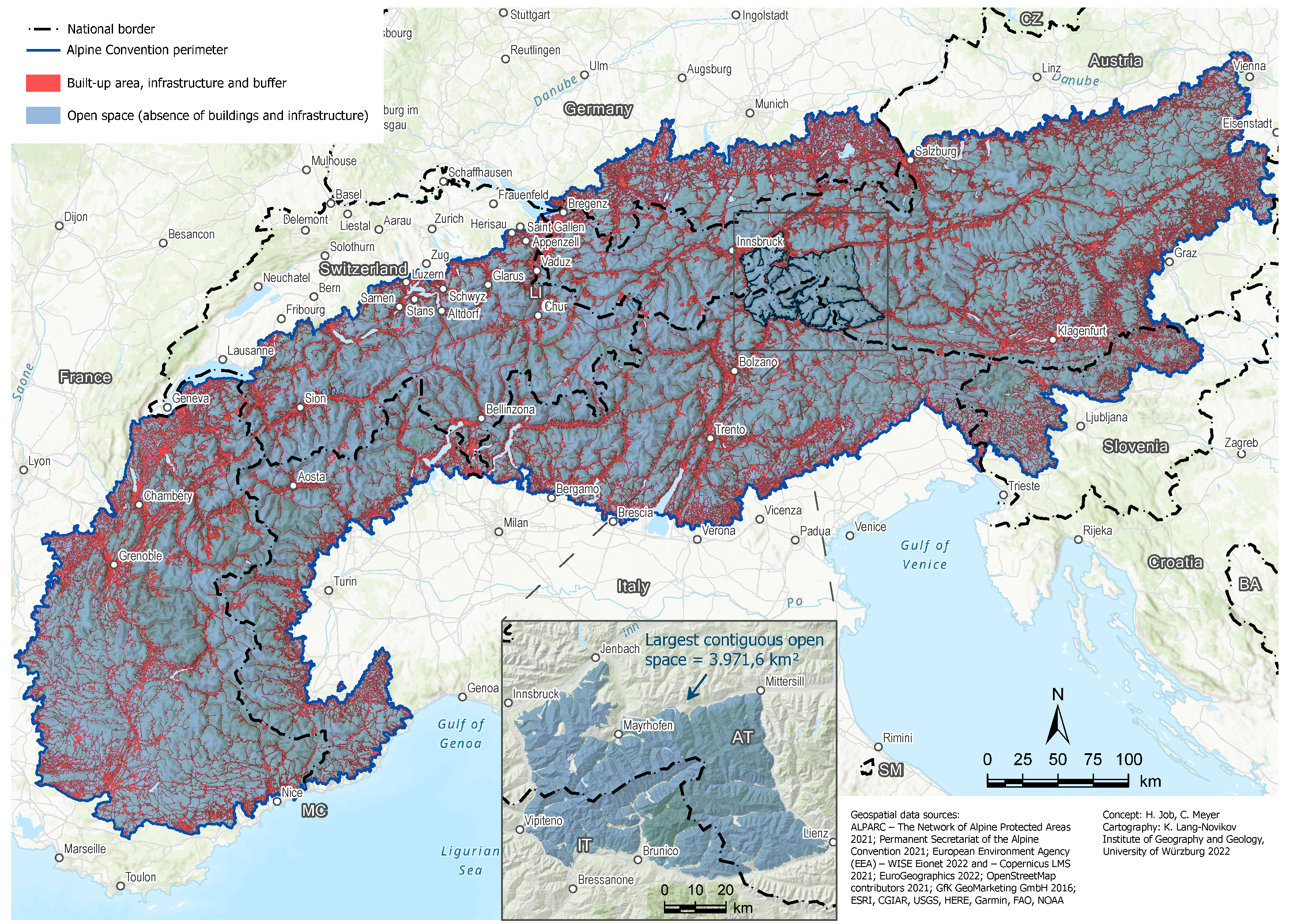
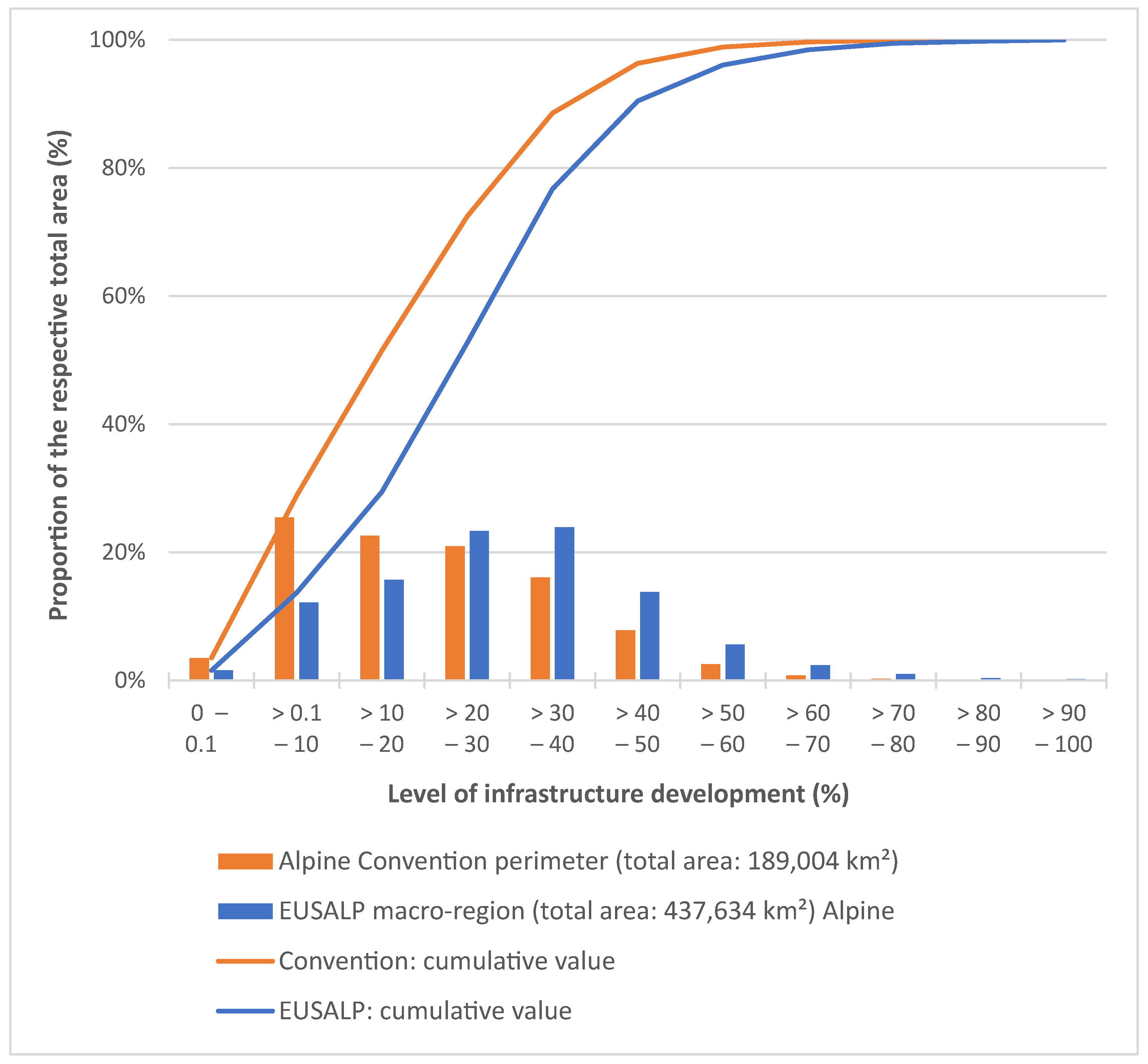
3.1. Binary Open Space Analysis

Once the selected layers of infrastructure and built-up areas have been buffered according to their spatially effective disturbance effect, a binary approach is taken, representing the infrastructure buffers as well as the remaining open spaces. This approach provides a total of 114,509 individual open space “patches,” which have a mean area size of 1.32 km2 (standard deviation: 31.2 km2). In total, these open spaces cover an area of 150,760.2 km2, which is about 79.8% of the Alpine Convention perimeter. The largest contiguous open space (cf. Figure 1), with an area of 3971.6 km2, is an area between Austria and Italy (North-, East- and South-Tyrol) with boundaries roughly located around Innsbruck, Bressanone/Brixen, Lienz and Mittersill, and thus comprising mainly of the areas of Tux and Zillertal Alps and the Hohe Tauern in the core (representing protected area designations such as national park, nature park, and “Tyrolean quiet areas”).
Figure 1 shows the spatial distribution. The red areas correspond to well-known patterns of settlement density in the Alps but also become more apparent in areas that feature a high density of cable cars and other technical lifts. Large inner alpine valleys such as the Inn valley, the Rhine valley, the Adige valley, or the Rhone valley are characterized by dense infrastructure coverage and thus have few remaining open spaces. A high degree of settlement sprawl (and thus landscape fragmentation) can be observed at the edges of the Alpine Convention perimeter, for example in Bavaria (DE), Haute-Savoie (FR), or Carinthia (AT).

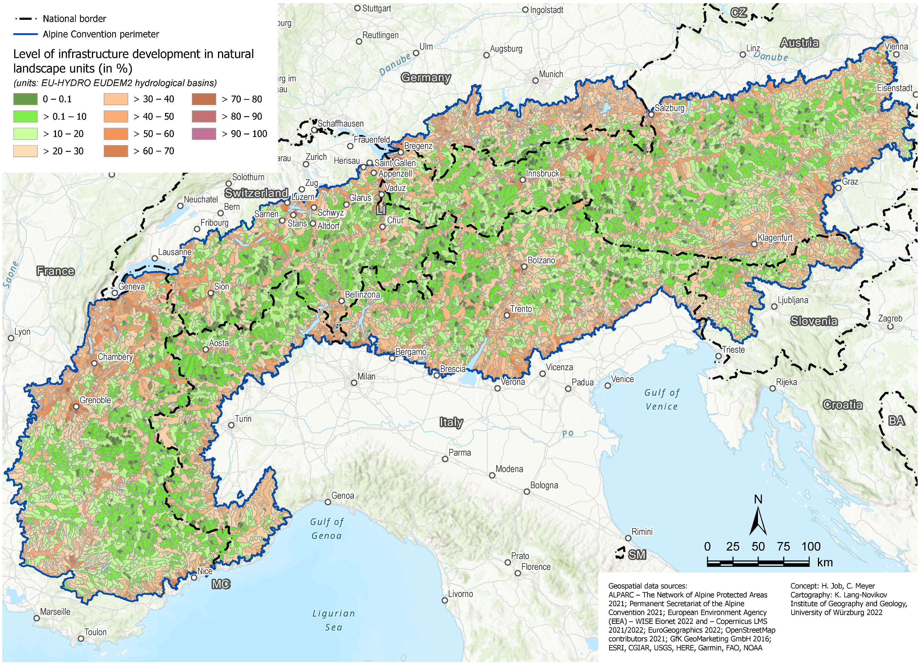
3.2. Analysis of Natural Landscape Units

The results obtained in the ”binary” approach (Section 3.1) already offer initial valuable insights but are not yet able to adequately show the structure and distribution of open spaces in the Alps, especially on a landscape scale. For this purpose, as described in the methodology, the degree of infrastructure development is calculated for small-scale hydrological catchments as natural landscape units. These also represent visual axes, since the spatial units in the alpine landscapes each respectively range between larger mountain ridges and thus delimit, e.g., valley areas. Of great importance here are those areas that can be classified as “pure” open spaces (level of infrastructure development: 0–0.1%) or near-natural open spaces (level of infrastructure development: up to 20%).
The analysis of infrastructure development levels is carried out in 10%-increments. In the Alpine Convention perimeter, near-natural areas with a degree of development of up to 20% account for 51.5% of the total area. The spaces marked as “pure” open spaces (0–0.1%) account for a share of 3.5% of the Alpine Convention perimeter. The largest share is formed in the class “>0.1–10%” with 25.4%, as can be seen in Figure 2. With an increase in the level of infrastructure development, a decrease in the respective area of the Alpine Convention perimeter can be observed so that areas with a medium level of infrastructural development (between 20% and 50%) account for about 44.8% of the total area. Highly developed landscape units (with a development level of more than 50%) form a share of 3.7% of the total Alpine Convention perimeter. Those areas with a very high development level (>80% or >90%) are mostly located in densely populated (peri-alpine) valley areas, such as Salzburg, Klagenfurt, or Geneva.
Figure 3 also shows the distribution of areas classified as immaculate (“pure”) open spaces. These are distributed across all states, mostly in inner alpine core areas, e.g., along the main alpine mountain ridges of the Hohe Tauern (AT) or the Bernese Alps (CH). Due to an accumulation of these undeveloped areas in high altitudes and peripheral regions, they are often located on national borders. This underlines the urgent call for cross-border spatial planning for open spaces of the OpenSpaceAlps project [22,50]. Of particular importance for spatial planning and nature conservation are those near-natural areas (infrastructure development of up to 20%) that are spatially interconnected, especially for wildlife and their migration corridors. Here, an accumulation can be observed in some alpine regions. These include, for example, large areas in Italy and Switzerland (north) west of Lago Maggiore or the Carnic Alps along the Italian-Austrian border.
To better contextualize the open space structure in the Alps, a comparison with extra-Alpine areas is useful. The EU Strategy for the Alpine Region (EUSALP) macro-region is suitable for this purpose since it was broadly delimited for political reasons and thus also includes extra-Alpine conurbations such as Munich (DE), Milan (IT) or Lyon (FR). It should be noted that the EUSALP macro-region includes the Alpine Convention perimeter, which forms its core area. Figure 2 shows how the share of the development levels changes when the remaining EUSALP areas are included in addition to the Alpine Convention perimeter. It is clearly noticeable that especially the classes “>20–30%” and “>30–40%” with 23.3% and 23.9% respectively, show the largest shares. In the EUSALP macro-region, near-natural areas (up to 20%) only account for a share of about 29.4% (compared with 51.5% in the Alpine Convention perimeter). Especially the share of “pure” open spaces is very low at 1.6%, and only about 0.05% (238 km2) can be found outside the Alpine Convention perimeter. The EUSALP perimeter areas, with high infrastructure development (>50%), are an exception, with a total share of 9.6% (compared with 3.7% for the Alpine Convention perimeter).

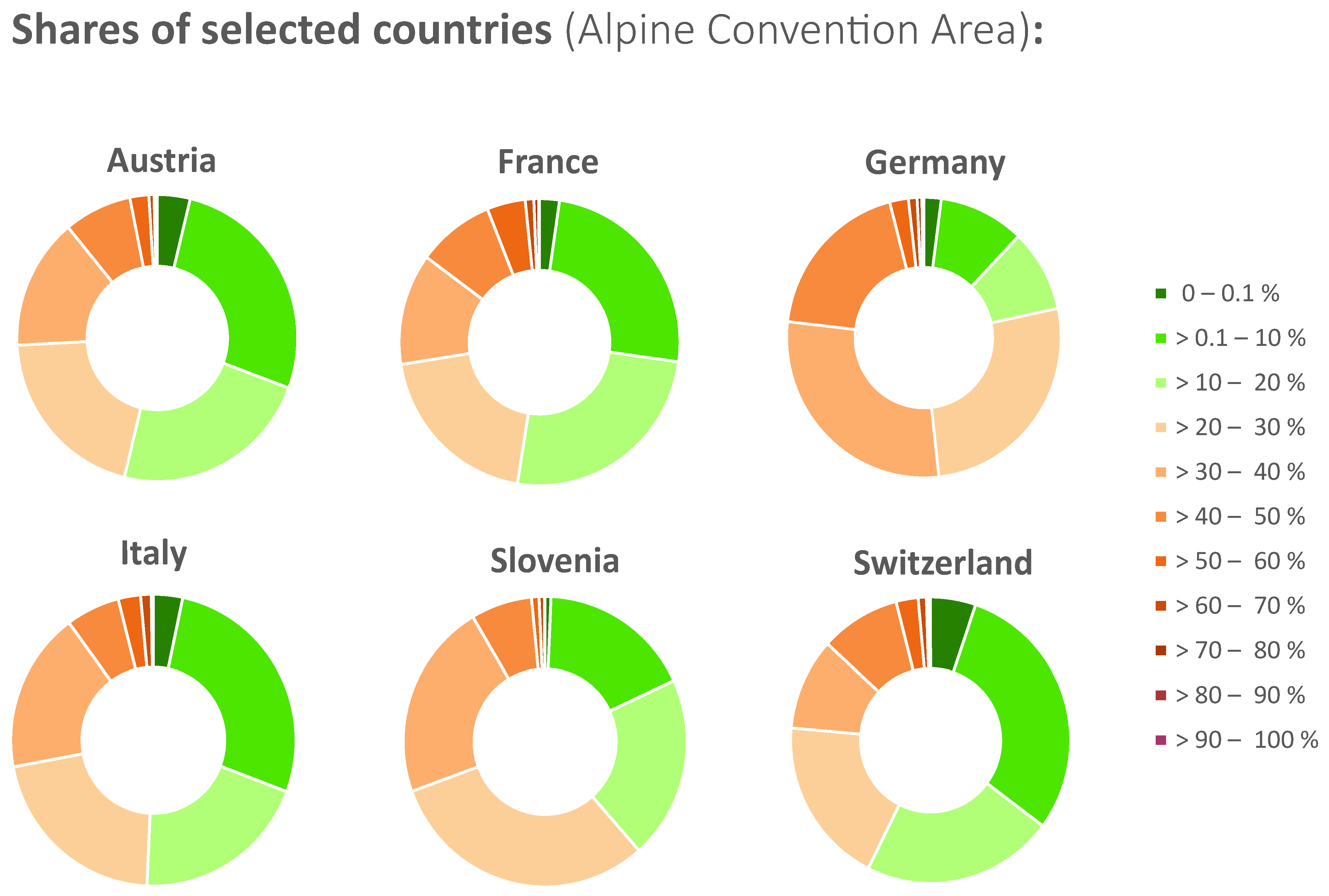
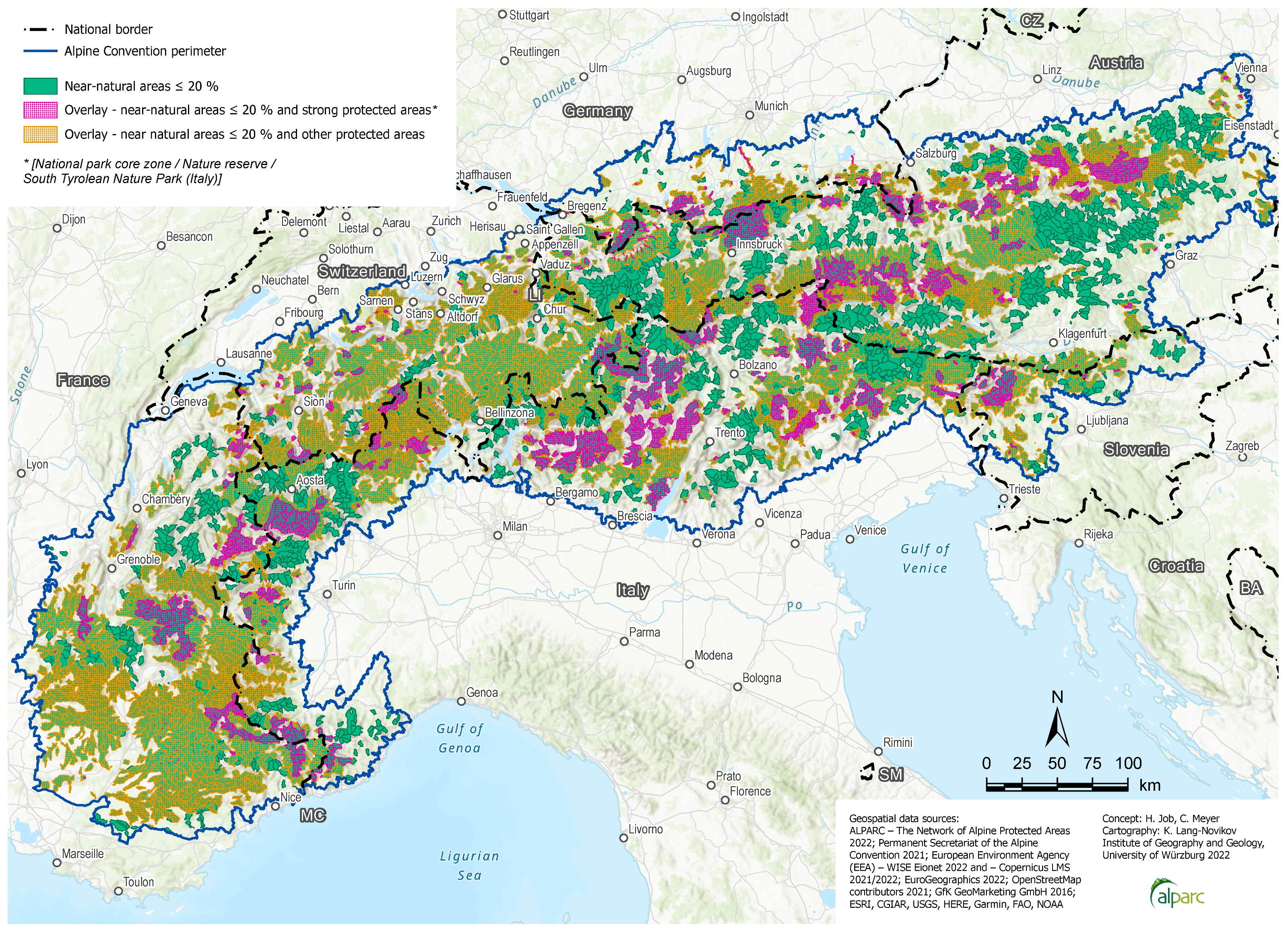
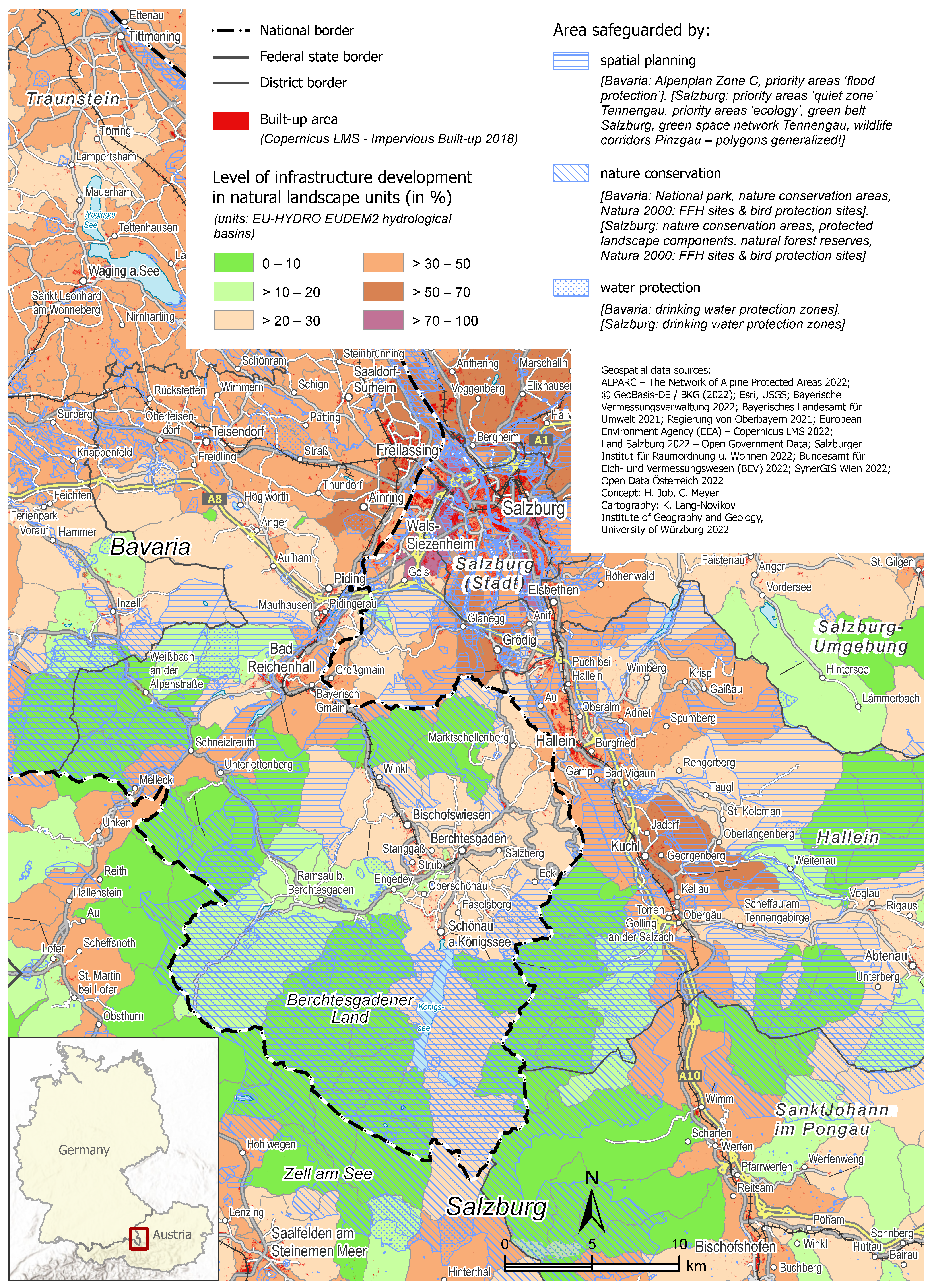
3.3. Spatial Differentiation and Overlay Analysis

Focussing on statistical analyses of the Alpine Convention perimeter, it is important to examine development at different altitudes in an alpine context. Therefore, the mean elevations are determined for different levels of development. The results show large differences, with infrastructure development decreasing gradually with increasing altitude (except for a few examples) (cf. Table 3). This is not surprising given the altitudinal dimension of alpine settlement structures, which is also determined by the settlement history of the Alps. Nevertheless, the analysis of the distribution according to altitude levels makes it clear that sparsely and undeveloped areas are almost only found at high altitudes of over 1500 (Northern and Southern Alps) or 2000 m (Central Alps) above sea level. This relates to the “worthless land” hypothesis [51], as these areas often represent spaces with little human land use competition.
As an additional differentiation, the distribution of the development share between the major Alpine countries (Monaco and Liechtenstein not considered) is of particular interest, which is visualized in Figure 4. The largest share of near-natural open spaces (level of infrastructure development up to 20%) is in the Alpine Convention perimeter of Switzerland (ca. 57.4%), followed by Austria (ca. 53.8%), France (ca. 52.5%) and Italy (ca. 50.7%). This percentage is significantly lower in the Slovenian (ca. 38.5%) and especially in the German (ca. 21.7%) Alps. The German section of the Alpine Convention perimeter is formed by the southernmost districts in the federal state of Bavaria, mainly featuring landscape units with a level of infrastructure development of between 20% and 50%. This is consistent with the previously expressed finding that the Bavarian Alpine foreland is characterized by significant settlement sprawl and development pressure [25]. This is partly because of the spatial proximity to dynamically growing agglomeration areas such as Munich (DE), Salzburg (AT) or Augsburg (DE) [25]. The distribution of the category “pure” open spaces between the Alpine countries is also interesting with Switzerland occupying a leading position with a share of 5.2%, followed by Austria (3.8%), Italy (3.3%), France (2.3%) and Germany (2.1%). In Slovenia, this share is at a comparatively low level of 0.7.
Conservation areas—based either on environmental or planning law—are an important instrument for safeguarding near-natural open spaces. With more than 53,000 km2, the Alpine protected area system covers about 28 percent of the Alpine Convention perimeter [52]. In an overlay analysis (Figure 5), the near-natural open spaces identified in the GIS analysis are placed in relation to the Alpine protected area system. Previously, the alpine protected areas were classified into “highly protected areas” (national park core zone, nature reserve, and Italian nature/regional park) and “other protected areas” (with a lower protection intensity) according to a classification by ALPARC. The results show that only 14.5% of the near-natural open spaces corresponded to highly protected areas and about 58.4% with other protected areas, with less conservation impact. Consequently, there is currently no overlay for about 27.2%.
As shown on the map (Figure 5), these areas are mostly located, e.g., in South Tyrol north of Bolzano/Bozen (IT), north-east of the Aosta Valley (IT), or in the Lechtal Alps (AT), and many other alpine regions without a specific spatial pattern. Spatially, however, it is noticeable that Switzerland and France have a high degree of protected area coverage. This is mainly because of weaker types of protected areas, such as, e.g., large-scale nature parks in the Southwest of the French Alps. The observation of a missing overlay does not necessarily mean that these areas are completely unprotected. It is rather difficult to establish an alpine-wide database on other open space protection instruments. Here, spatial planning can play a coordinating role in bridging bottlenecks between protected areas and safeguarding important open space corridors. Therefore, an example of cross-border analysis of spatial planning (also concerning nature conservation and water protection designations) between Germany and Austria is presented in Section 4.3.

4. Discussion

The results of this paper can be summarized as follows: There are hardly any open spaces left in the European Alpine Space that are completely free from human land use. There are still near-natural areas covering about half of the total area with a very small human footprint (concerning the existence of buildings and infrastructure). These near-natural areas tend to be located at high altitudes where there is (almost) no land use competition (above 1500–2000 m elevation). They are therefore unsuitable to be used as connections between habitat “islands.” Open spaces that still exist at the lower altitudes around permanent settlement space (below 1000 m elevation) should be preserved and better protected. More specifically, new land use competitions, especially with the expansion of renewable energies, must be addressed in the following discussion.

4.1. Methods

The GIS-based mapping of open spaces provides a general delimitation of areas with little or no infrastructure in the European Alps. A more detailed delimitation applicable to the regional and local levels would require improvements in the availability, comparability, and accuracy of data. The methodology developed had to address a well-known fundamental problem: the lack of comparable high-resolution land use and infrastructure geodata between European countries and regions. This is also connected to the conceptual problem relating to research on land take/land consumption [2,53], with only a few comprehensive contributions to the scientific literature on the extra-urban open spaces on the landscape level [36]. Approaches to harmonize official data and remove inconsistencies in land use and land cover data, such as the European EAGLE [54] initiative, should be advanced and implemented to enable research approaches such as the one presented here. The use of OpenStreetMap data for key components of the GIS analysis (infrastructure layers such as roads, railways, cable cars, and power lines) has provided a solid basis for analyzing the status quo but is unsuitable for continuous monitoring. This is because it cannot be determined whether land use changes result from real changes or only from an update/improvement of the data from the OpenStreetMap community. In contrast, the continuously updated data of the Copernicus Land Monitoring Service is of great value. The Corine Land Cover data [42] offer the longest time series but only a low spatial resolution with a minimum mapping unit of 25 ha. In particular, the high-resolution layers, especially the Impervious Built-up Layer [43], which has been available since 2018, are promising for continuous transnational monitoring but also feature some methodological weaknesses [47]. The method carried out is only an initial step in the analysis of open spaces. To generate more relevant databases for spatial planning decisions, analyses of this kind must, in the future, include more qualitative aspects of open spaces such as ecosystem services (e.g., specific soil functions or habitat functions).
The long-term evolution and prospects of open spaces should be supported by the monitoring of commonly defined key indicators, which are derived from the binding obligations of the Alpine Convention Protocols. Based on common quantitative and qualitative criteria and a harmonized international data basis, a practical definition should be agreed on among alpine countries to support transnational coordination of spatial planning. Furthermore, a standardized permanent Alps-wide monitoring system might be implemented to observe and identify the development of open spaces and their modification by quantitative and qualitative impacts [50]. It should cover the Alps according to the delimitation of the Alpine Convention (with the most sensitive near natural landscapes) and could comprehensively improve protected areas [55] as core zones.

4.2. Emerging Pressures on Open Spaces

Unbuilt open spaces are challenged by different pressure factors. In Europe, the annual rate of land take and consequent habitat loss has gradually slowed, but ecosystems are still under pressure from the fragmentation of peri-urban and rural landscapes [1]. From a European perspective, the following six factors can be summarized as the most significant threats and pressures for ecosystems [56]: climate change, invasive species, fragmentation, land use change, pollution, and overexploitation—for the Alps, this also counts as true [57]. The analysis showed the quantitative dimension of the remaining open spaces in the European Alps. For future work, however, it will be even more important to complement such analyses with qualitative criteria. Examples of these potential qualitative criteria are High nature value (HNV) farmland [27,58] or soil functions/soil quality indices [59,60]. To establish scientifically sound monitoring approaches of open spaces and their pressures, a better comparison of timelines and the underlying data is required, as identified in Section 4.1.
The most prominent emerging pressure is the growing land use pressure from renewable energy installations, such as solar power plants, which might be built increasingly in open areas of Alpine landscapes, to achieve sufficient renewable energy production. This can be exemplified by the Austrian federal state of Tyrol, which has set itself the goal of increasing the share of solar power to thirty percent by 2050. This means that solar power production in Tyrol would have to be increased by about thirty times over the next 30 years [60]. Another example is Böhm et al. (2022) [61], who showed that ground-mounted photovoltaics (GM PV) in Germany feature a higher land demand (around 25,500 ha) compared with previous estimates. Their analysis shows that by 2018 around 52% of GM PV have been constructed on arable land as well as 15% on grassland, resulting in a share of only 33% for conversion areas and other land use types. In South Tyrol, Italy, photovoltaic systems may only be installed on roof surfaces. For South Tyrol, Moser et al. (2014) [62] showed that the goals for renewable energy supply could be achieved when using non-conventional surfaces (e.g., artificial lakes and transport infrastructure). In. addition, in other Alpine countries, transport-area-integrated photovoltaics near roadways and railways (e.g., noise barriers, roadside embankments, and road roofing systems) could be a probable solution [63]. The photovoltaic development over sealed surfaces without additional land consumption could be a return on investment with infrastructure projects and increase the acceptance of the extension of photovoltaic energy sources in society.
In light of the necessary expansion acceleration of renewable energy sources, spatial planning has a special coordination function: to simultaneously manage the energy transition and qualitatively develop open spaces, preserving their most important ecosystem services. From a research perspective, this would increase the need for tailored impact assessment of renewable energy installations [61] and joint strategies/methods for spatial and energy planning [62]. Renewable energies were not directly included in the analysis of this article. This is mainly because hardly any reliable geodata is available for energy sources such as wind turbines or ground-mounted photovoltaic plants, which would enable a transnational analysis. To include it in spatial monitoring, it is necessary to create European-wide geodata for the use and planning of renewable energies, which should also be accessible for research purposes.

4.3. Role of Spatial Planning

To date, spatial planning has been based on legally defined responsibilities concerned with the built environment, focusing on requirements for living, working, and transport. From a comparative, transnational perspective, the ESPON COMPASS project defines spatial planning as “the ensemble of institutions that are used to mediate competition over the use of land and property, to allocate rights of development, to regulate change and to promote preferred spatial and urban form” [63]. Open spaces have thus far mostly been considered as residual areas due to their negative definition. We advocate that for ecological connectivity reasons, tailored planning strategies for open spaces are needed to safeguard them from further urbanization and fragmentation [41].
There is a lack of cross-border planning coordination between Alpine countries and regions relating to protected areas as sectoral planning instruments and open spaces serving as connectivity landscapes [64]. Regional planning should focus on certain key issues of supra-local relevance, such as interconnected open space networks or the coordination of tourism infrastructures. Coordination between the municipalities within the framework of regional planning procedures should be guided by developing regional concepts of settlement and open space development. Spatial planning should put a stronger focus on the implementation of agricultural priority areas in valleys, ecological corridors, and large recreational open spaces [50,65]. Neighboring regions should commit to consulting each other in regional planning procedures. For highly interdependent bordering areas, such as cross-border agglomerations, joint strategic planning documents should be elaborated or enhanced (e.g., “Masterplan Kernregion Salzburg”) to provide bilateral strategic guidelines for spatial planning. This shall endeavor to reduce cross-border competition for residents, businesses, and retail locations as a driving force of urban sprawl. Rather, such planning decisions should be coordinated across borders to determine the most suitable locations and minimize land take [41].
There are many examples of successful spatial planning interventions, such as the Bavarian Alpenplan [66]. However, area-wide data on spatial planning designations relevant for the safeguarding of open spaces are not available at an alpine-wide scale. Figure 6 shows the specific border region between Germany (Federal State of Bavaria) and Austria (Federal State of Salzburg), for which data/evidence on relevant spatial planning designations was compiled for this article.
In addition to the infrastructural development of the natural landscape units (hydrological basins) presented in Section 3, area-related designations of (supra-local) spatial planning, nature conservation, and water protection on both sides of the German-Austrian border are indicated. In all blue area types shown, building construction or development with new technical infrastructure is generally not permitted. The difference between densely populated areas (e.g., the transnational Salzburg metropolitan area and the Salzach valley) and the more rural areas can be seen. In the southern part of the Berchtesgadener Land district, there is a comparatively extensive coverage of planning instruments that safeguard open space, most prominently the Berchtesgaden National Park. This is continued on the other side of the border with protected areas in the state of Salzburg, strengthening supra-local ecological connectivity. In contrast, the northern part of Berchtesgadener Land only has only a few areas designated for the safeguarding of open space, primarily for the protection of drinking water sources. This area is influenced by the dynamic growth of the city of Salzburg with a continuous risk of land take for buildings and infrastructure at the expense of agricultural production areas resulting in landscape fragmentation. There are also differences in the intensity and coverage of planning instruments in the federal state of Salzburg. For example, in the planning region Tennengau (district Hallein), there is a large-scale “Alpine quiet zone” as a regional planning instrument, which does not exist in other sub-regions.

5. Conclusions and Outlook

Global change is causing new crosscutting challenges where the safeguarding of open spaces is an important solution as they provide climate, groundwater and flood, natural heritage (biodiversity) protection, and soil conservation. Stakeholders should strive to connect the topic of safeguarding open spaces with these future key challenges [50]. It is, therefore, high time to describe the term “open space” in a proactive and positive manner. Planning instruments need to integrate ecosystem services delivered within open spaces into their regulatory portfolio [40,67,68]. Renewable energy production requires additional land and contributes to emerging land use conflicts. Planning needs to have the foresight to address these arising pressures caused by the requirements from the green energy transition (and the problematic dependence of Central European countries on the import of fossil energy sources) in advance. That is why spatial planning must act in anticipation of emerging land use trends by developing criteria to delimit specific exclusionary areas to spatially coordinate renewable energy installations and diminish their impact on the land take and landscape fragmentation [41].
Alpine open spaces must be maintained and deliberately safeguarded through enhanced spatial and sectoral planning instruments for biodiversity, the reduction of natural hazards, and climate change mitigation. We have learned that most remaining open spaces tend to be in high altitudes of over 1500 m (Northern and Southern Alps) or 2000 m (Central Alps) above sea level. Those areas must soon receive an enhanced protection status to be able to fulfill the 30 × 30 CBD [Convention on Biological Diversity] COP 15 Kunming goal [69]. Agricultural land in the Alpine valleys is mostly affected by land take. Therefore, particular attention must be paid to the preservation of productive agricultural soil. In addition, ecological connectivity requires the safeguarding of green corridors on valley floors to link the core areas mentioned above [41]. As nature-based solutions [70,71] in spatial planning, green corridors must further be identified through targeted data-based analysis and comprehensively defined in spatial planning documents at the regional and local levels. In addition, in valleys that feature major connectivity barriers (such as major roads or railways), technical solutions such as green bridges (wildlife crossings) need to be installed to restore ecological connectivity in the Alps [41].

Author Contributions

Conceptualization, H.J. and C.M.; Methodology, H.J., C.M., G.P., O.C., P.L., W.R. and S.K.; Data curation, O.C., S.K., C.M., P.L. and W.R.; Formal analysis, O.C. and C.M.; Project administration, P.V., G.P. and A.O.; Supervision, H.J. and A.S.; Visualization, C.M. and O.C.; Writing—original draft, H.J. and C.M.; Writing—Review and Editing, A.S. and S.K. All authors have read and agreed to the published version of the manuscript.

Funding

This research was funded by the “OpenSpaceAlps” (ASP886) project, co-financed by the European Regional Development Fund (ERDF) through the Interreg Alpine Space program. This publication was supported by the Open Access Publication Fund of the University of Wuerzburg.

Data Availability Statement

Publicly available datasets from Copernicus Land Monitoring Service and OpenStreetMap were analyzed and processed in this study. The resulting geodata for the central result (level of infrastructure development) can be found here (ArcGIS Feature Server): https://services5.arcgis.com/qjjtr5pMpt3PDiiR/arcgis/rest/services/Job_et_al__2022__Level_of_infrastructure_development/FeatureServer (accessed on 10 September 2022).

Acknowledgments

The authors gratefully acknowledge the willingness to provide information about the involved institutions and their experts. Special thanks to the Academy of Territorial Development in the Leibniz Association (ARL) for the indispensable logistic support of AlpPlan, the Alpine Spatial Planning Network. The authors would also like to thank Katrin Lang-Novikov for her great support with the production of maps.

Conflicts of Interest

The authors declare no conflict of interest. The funders had no role in the design of the study, in the collection, analyses, or interpretation of data, in the writing of the manuscript, or in the decision to publish the results.

Notes

1
EU Strategy for the Alpine Region (EUSALP), cf. www.alpine-region.eu (accessed on 1 September 2022).
2
Land use analysis using Corine Land Cover 2018 data. Available online: https://land.copernicus.eu/pan-european/corine-land-cover/clc2018?tab=metadata (accessed on 2 August 2022).
3
According to ALPARC [23] Strategic Alpine Connectivity Areas (SACA) consist of: Ecological Conservation Areas (SACA 1), Ecological Intervention Areas (SACA 2) and Connectivity Restoration Areas (SACA 3).

References

  1. The European Environment—State and Outlook 2020. In Knowledge for Transition to a Sustainable EUROPE; European Environment Agency: Copenhagen, Denmark, 2019.
  2. Marquard, E.; Bartke, S.; Gifreu i Font, J.; Humer, A.; Jonkman, A.; Jürgenson, E.; Marot, N.; Poelmans, L.; Repe, B.; Rybski, R.; et al. Land Consumption and Land Take: Enhancing Conceptual Clarity for Evaluating Spatial Governance in the EU Context. Sustainability 2020, 12, 8269. [Google Scholar] [CrossRef]
  3. Barbosa, A.; Vallecillo, S.; Baranzelli, C.; Jacobs-Crisioni, C.; Batista e Silva, F.; Perpiña-Castillo, C.; Lavalle, C.; Maes, J. Modelling built-up land take in Europe to 2020: An assessment of the Resource Efficiency Roadmap measure on land. J. Environ. Plan. Manag. 2016, 60, 1439–1463. [Google Scholar] [CrossRef]
  4. Meyer, C.; Peters, J.C.; Thiel, M.; Rathmann, J.; Job, H. Monitoring der Freiflächeninanspruchnahme und -versiegelung als Beitrag für eine nachhaltige Raumentwicklung in Bayern. Raumforsch. Raumordn. Spat. Res. Plan. 2021, 79, 172–189. [Google Scholar] [CrossRef]
  5. Hock, R.; Rasul, G.; Adler, C.; Cáceres, B.; Gruber, S.; Hirabayashi, Y.; Jackson, M.; Kääb, A.; Kang, S.; Kutuzov, S.; et al. High Mountain Areas. In IPCC Special Report on the Ocean and Cryosphere in a Changing Climate; Pörtner, H.-O., Roberts, D.C., Masson-Delmotte, V., Zhai, P., Tignor, M., Poloczanska, E., Mintenbeck, K., Alegría, A., Nicolai, M., Okem, A., et al., Eds.; Cambridge University Press: Cambridge, UK; New York, NY, USA, 2022; pp. 131–202. [Google Scholar]
  6. Gobiet, A.; Kotlarski, S.; Beniston, M.; Heinrich, G.; Rajczak, J.; Stoffel, M. 21st century climate change in the European Alps—A review. Sci. Total Environ. 2014, 493, 1138–1151. [Google Scholar] [CrossRef] [PubMed]
  7. Gobiet, A.; Kotlarski, S. Future Climate Change in the European Alps. In Oxford Research Encyclopedia of Climate Science; Oxford University Press: Oxford, UK, 2020. [Google Scholar]
  8. Gurung, A.B.; Borsdorf, A.; Füreder, L.; Kienast, F.; Matt, P.; Scheidegger, C.; Schmocker, L.; Zappa, M.; Volkart, K. Rethinking Pumped Storage Hydropower in the European Alps. Mt. Res. Dev. 2016, 36, 222–232. [Google Scholar] [CrossRef]
  9. Vanham, D. The Alps under climate change: Implications for water management in Europe. J. Water Clim. Chang. 2012, 3, 197–206. [Google Scholar] [CrossRef]
  10. Schindelegger, A. Natural Hazard Risk Governance. Report on the State of the Alps; Alpine Convention: Mountain View, CA, USA, 2019. [Google Scholar]
  11. Einhorn, B.; Eckert, N.; Chaix, C.; Ravanel, L.; Deline, P.; Gardent, M.; Boudières, V.; Richard, D.; Vengeon, J.-M.; Giraud, G.; et al. Climate change and natural hazards in the Alps. Rev. Géogr. Alp. 2015, 103-2, 1–39. [Google Scholar] [CrossRef]
  12. Fuchs, S.; Röthlisberger, V.; Thaler, T.; Zischg, A.; Keiler, M. Natural Hazard Management from a Coevolutionary Perspective: Exposure and Policy Response in the European Alps. Ann. Am. Assoc. Geogr. 2016, 107, 382–392. [Google Scholar] [CrossRef]
  13. Raška, P.; Bezak, N.; Ferreira, C.S.S.; Kalantari, Z.; Banasik, K.; Bertola, M.; Bourke, M.; Cerdà, A.; Davids, P.; Madruga de Brito, M.; et al. Identifying barriers for nature-based solutions in flood risk management: An interdisciplinary overview using expert community approach. J. Environ. Manag. 2022, 310, 114725. [Google Scholar] [CrossRef]
  14. Job, H.; Mayer, M.; Haßlacher, P.; Nischik, G.; Knauf, C.; Pütz, M.; Essl, J.; Marlin, A.; Kopf, M.; Obkircher, S. Analysing, Assessing and Safeguarding Alpine Open Spaces through Spatial Planning; ARL—Academy for Territorial Development in the Leibniz Association: Hannover, Germany, 2017. [Google Scholar]
  15. The Alpine Region and Its Key Environmental Challenges. Available online: https://www.eea.europa.eu/themes/regions/the-alpine-region/key-environmental-challenges/key-environmental-challenges/challenges (accessed on 1 August 2022).
  16. Heeb, J.; Hindenlang, K. Negotiating Landscape in the Swiss Alps. Mt. Res. Dev. 2008, 28, 105–109. [Google Scholar] [CrossRef] [Green Version]
  17. Schirpke, U.; Scolozzi, R.; Dean, G.; Haller, A.; Jäger, H.; Kister, J.; Kovács, B.; Sarmiento, F.O.; Sattler, B.; Schleyer, C. Cultural ecosystem services in mountain regions: Conceptualising conflicts among users and limitations of use. Ecosyst. Serv. 2020, 46, 101210. [Google Scholar] [CrossRef]
  18. Bätzing, W. Die Alpen. Geschichte und Zukunft Einer Europäischen Kulturlandschaft; C.H.BECK: München, Germany, 2015. [Google Scholar]
  19. Mayer, M.; Mose, I. The opportunity costs of worthless land: The nexus between national parks and glacier ski resorts in the Alps. Eco.mont 2017, 9, 35–45. [Google Scholar] [CrossRef]
  20. Sonderegger, R.; Bätzing, W. Second homes in the Alpine Region. Rev. Géogr. Alp. 2013, 1–14. [Google Scholar] [CrossRef]
  21. Elmi, M. Sustainable tourism perspectives for Alpine destinations. In Destination und Lebensraum; Entrepreneurial Management und Standortentwicklung; Springer: Wiesbaden, Germany, 2019; pp. 195–204. [Google Scholar]
  22. Meyer, C.; Job, H.; Laner, P.; Omizzolo, A.; Kollmann, N.; Clare, J.; Vesely, P.; Riedler, W.; Plassmann, G.; Coronado, O.; et al. OpenSpaceAlps Planning Handbook: Perspectives for Consistent Safeguarding of Open Spaces in the Alpine Region; Würzburg/Salzburg/Bolzano/Chambéry/Ljubljana/Rome. 2022. Available online: https://nbn-resolving.org/urn:nbn:de:bvb:20-opus-270401 (accessed on 1 September 2022).
  23. ALPARC—The Alpine Network of Protected Areas. ALPBIONET2030. Integrative Alpine Wildlife and Habitat Management for the Next Generation. Spatial Analysis and Perspectives of [Ecological] Connectivity in the Wider Alpine Areas; Extremdruck: Chambéry, France, 2019. [Google Scholar]
  24. Egner, H.; Jungmeier, M. Non-Territorial Nature Conservation? On Protected Areas in the Anthropocene. Mitt. Der Österreichischen Geogr. Ges. 2019, 1, 115–142. [Google Scholar] [CrossRef]
  25. Job, H.; Meyer, C. 50 Jahre Bayerischer Alpenplan—Würdigung und Plädoyer für eine Weiterentwicklung. Nat. Landschaft. Z. Nat. Landsch. 2022, 97, 117–123. [Google Scholar] [CrossRef]
  26. Paranunzio, R.; Laio, F.; Chiarle, M.; Nigrelli, G.; Guzzetti, F. Climate anomalies associated with the occurrence of rockfalls at high-elevation in the Italian Alps. Nat. Hazards Earth Syst. Sci. 2016, 16, 2085–2106. [Google Scholar] [CrossRef]
  27. ALPARC—The Alpine Network of Protected Areas. The Evolution of Open Spaces in the Alps—Between Land-Use and Conservation for Generations to Come; Interreg Alpine Space Project Open Space Alps: Chambéry, France, 2021. [Google Scholar]
  28. Kopf, M.; Marlin, A.; Obkircher, S. Wenig Erschlossene Landschaftsräume. Inventar Weißzone; Amt der Vorarlberger Landesregierung: Bregenz, Austria, 2017. [Google Scholar]
  29. Nischik, G.; Pütz, M. Naturnahe Freiräume in der Schweiz: Analysekonzept, Identifizierung und Raumplanerische Sicherung; Eidg. Forschungsanstalt für Wald, Schnee und Landschaft WSL: Birmensdorf, Switzerland, 2018. [Google Scholar]
  30. Kienast, F.; Frick, J.; Steiger, U. Neue Ansätze zur Erfassung der Landschaftsqualität. Zwischenbericht Landschaftsbeobachtung Schweiz (LABES); BAFU: Bern, Switzerland, 2013. [Google Scholar]
  31. Haller, R. Mapping relevant factors for ecological connectivity—The JECAMI mapping service. In Alpine Nature 2030. Creating [Ecological] Connectivity for Generations to Come; Federal Ministry for the Environment, Nature Conservation, Building and Nuclear Safety (BMUB): Berlin, Germany, 2016; pp. 137–146. [Google Scholar]
  32. Gallaun, H.; Dohr, K.; Puhm, M.; Stumpf, A.; Hugé, J. Copernicus Land Monitoring Service. Reference Data: EU-Hydro. River Net User Guide 1.3; European Environment Agency: Copenhagen, Denmark, 2019.
  33. Ritter, E.-H. Freiraum/Freiraumschutz. In Handwörterbuch der Raumordnung; ARL—Akademie für Raumforschung und Landesplanung/Academy for Territorial Development in the Leibniz Association: Hannover, Germany, 2005; pp. 336–340. [Google Scholar]
  34. Baier, H.; Erdmann, F.; Holz, R.; Klenke, R.; Waterstraat, A. Problemaufriss und Forschungsansatz. In Freiraum und Naturschutz. Die Wirkungen von Störungen und Zerschneidungen in der Landschaft; Baier, H., Erdmann, F., Holz, R., Klenke, R., Waterstraat, A., Eds.; Springer: Berlin/Heidelberg, Germany, 2006; pp. 3–16. [Google Scholar]
  35. Maruani, T.; Amit-Cohen, I. Open space planning models: A review of approaches and methods. Landsc. Urban Plan. 2007, 81, 1–13. [Google Scholar] [CrossRef]
  36. Job, H.; Willi, G.; Mayer, M.; Pütz, M. Open Spaces in Alpine Countries: Analytical Concepts and Preservation Strategies in Spatial Planning. Mt. Res. Dev. 2020, 40, D1–D11. [Google Scholar] [CrossRef]
  37. Monteiro, R.; Ferreira, J.; Antunes, P. Green Infrastructure Planning Principles: An Integrated Literature Review. Land 2020, 9, 525. [Google Scholar] [CrossRef]
  38. Seiwert, A.; Rößler, S. Understanding the term green infrastructure: Origins, rationales, semantic content and purposes as well as its relevance for application in spatial planning. Land Use Policy 2020, 97, 104785. [Google Scholar] [CrossRef]
  39. Von Haaren, C.; Lovett, A.A.; Albert, C. Landscape Planning with Ecosystem Services. Theories and Methods for Application in Europe; Springer Nature: Dodrecht, The Netherland, 2019; Volume 24. [Google Scholar]
  40. Ronchi, S. Ecosystem Services for Spatial Planning. Innovative Approaches and Challenges for Practical Applications; Springer International: Cham, Switzerland, 2018. [Google Scholar]
  41. Bartol, B.; Červek, J.; Fanjeau, B.; Humerca Šolar, L.; Job, H.; Klee, A.; Laner, P.; Lintzmeyer, F.; Meyer, C.; Novljan, Ž.; et al. Safeguarding Open Spaces in the Alpine Region; ARL—Academy for Territorial Development in the Leibniz Association: Hannover, Germany, 2022. [Google Scholar]
  42. Corine Land Cover (CLC) 2018, Version 2020_20u1 (Metadata). Available online: https://land.copernicus.eu/pan-european/corine-land-cover/clc2018?tab=metadata (accessed on 2 August 2022).
  43. High Resolution Layer: Impervious Built-Up (IBU) 2018 (Metadata). Available online: https://land.copernicus.eu/pan-european/high-resolution-layers/imperviousness/status-maps/impervious-built-up-2018?tab=metadata (accessed on 1 August 2022).
  44. Ali, M.; Barrington-Leigh, C.; Millard-Ball, A. The world’s user-generated road map is more than 80% complete. PLoS ONE 2017, 12, e0180698. [Google Scholar] [CrossRef]
  45. Jokar Arsanjani, J.; Mooney, P.; Zipf, A.; Schauss, A. Quality Assessment of the Contributed Land Use Information from OpenStreetMap Versus Authoritative Datasets. In OpenStreetMap in GIScience; Lecture Notes in Geoinformation and Cartography; Springer: Cham, Switzerland, 2015; pp. 37–58. [Google Scholar]
  46. Koblar, S.; Pajk Koblar, V. Analiza prometne dostopnosti s podatki OpenStreetMapa. In GIS-i v Sloveniji—Modeliranje Pokrajine; Založba ZRC: Ljubljana, Slovenia, 2020; pp. 165–173. [Google Scholar] [CrossRef]
  47. Strand, G.-H. Accuracy of the Copernicus High-Resolution Layer Imperviousness Density (HRL IMD) Assessed by Point Sampling within Pixels. Remote Sens. 2022, 14, 3589. [Google Scholar] [CrossRef]
  48. Zhou, Q.; Wang, S.; Liu, Y. Exploring the accuracy and completeness patterns of global land-cover/land-use data in OpenStreetMap. Appl. Geogr. 2022, 145, 102742. [Google Scholar] [CrossRef]
  49. European Digital Elevation Model (EU-DEM), Version 1.1 (Metadata). Available online: https://land.copernicus.eu/imagery-in-situ/eu-dem/eu-dem-v1.1?tab=metadata (accessed on 1 August 2022).
  50. Schoßleitner, R.; Vesely, P.; Job, H.; Meyer, C.; Laner, P.; Omizzolo, A.; Plassmann, G.; Coronado, O.; Praper Gulič, S.; Gulič, A.; et al. OpenSpaceAlps Strategic Recommendations. Extended Version; Salzburg/Würzburg/Bolzano/Chambéry/Ljubljana/Rome. 2022. Available online: https://www.eurac.edu/en/institutes-centers/institute-for-regional-development/projects/openspacealps (accessed on 1 September 2022).
  51. Runte, A. Worthless“ lands—Our national parks: The enigmatic past and uncertain future of America’s scenic wonderlands. Am. West 1973, 10, 4–11. [Google Scholar]
  52. ALPARC—The Alpine Network of Protected Areas. The Protected Areas. Available online: https://alparc.org/the-protected-areas (accessed on 3 August 2022).
  53. Colsaet, A.; Laurans, Y.; Levrel, H. What drives land take and urban land expansion? A systematic review. Land Use Policy 2018, 79, 339–349. [Google Scholar] [CrossRef]
  54. Arnold, S.; Smith, G.; Hazeu, G.; Kosztra, B.; Perger, C.; Banko, G.; Soukup, T.; Strand, G.-H.; Valcarcel Sanz, N.; Bock, M. The EAGLE Concept: A Paradigm Shift in Land Monitoring. In Land Use and Land Cover Semantics: Principles, Best Practices and Prospects; Ahlqvist, O., Varanka, D., Fritz, S., Janowicz, K., Eds.; CRC Press: Boca Raton, FL, USA, 2016; pp. 107–144. [Google Scholar]
  55. Bender, O.; Roth, C.E.; Job, H. Protected areas and population development in the Alps. J. Prot. Mt. Areas Res. Manag. 2017, 9, 5–16. [Google Scholar] [CrossRef]
  56. Threats & Pressures. Available online: https://biodiversity.europa.eu/threats (accessed on 1 August 2022).
  57. Egarter Vigl, L.; Marsoner, T.; Schirpke, U.; Tscholl, S.; Candiago, S.; Depellegrin, D. A multi-pressure analysis of ecosystem services for conservation planning in the Alps. Ecosyst. Serv. 2021, 47, 101230. [Google Scholar] [CrossRef]
  58. Data: High Nature Value (HNV) Farmland. Available online: https://www.eea.europa.eu/data-and-maps/data/high-nature-value-farmland-1 (accessed on 8 September 2022).
  59. Greiner, L.; Keller, A.; Grêt-Regamey, A.; Papritz, A. Soil function assessment: Review of methods for quantifying the contributions of soils to ecosystem services. Land Use Policy 2017, 69, 224–237. [Google Scholar] [CrossRef]
  60. Drobnik, T.; Greiner, L.; Keller, A.; Grêt-Regamey, A. Soil quality indicators—From soil functions to ecosystem services. Ecol. Indic. 2018, 94, 151–169. [Google Scholar] [CrossRef]
  61. Poggi, F.; Firmino, A.; Amado, M. Planning renewable energy in rural areas: Impacts on occupation and land use. Energy 2018, 155, 630–640. [Google Scholar] [CrossRef]
  62. Stöglehner, G.; Neugebauer, G.; Erker, S.; Narodoslawsky, M. Integrated Spatial and Energy Planning. Supporting Climate Protection and the Energy Turn with Means of Spatial Planning; Springer Nature: Berlin, Germany, 2016. [Google Scholar]
  63. Nadin, V.; Fernández Maldonado, A.M.; Zonneveld, W.; Stead, D.; Dabrowski, M.; Piskorek, K.; Sarkar, A.; Schmitt, P.; Smas, L.; Cotella, G.; et al. COMPASS—Comparative Analysis of Territorial Governance and Spatial Planning Systems in Europe. Final Report; ESPON EGTC: Luxembourg, 2018. [Google Scholar]
  64. Haßlacher, P.; Pütz, M.; Nischik, G.; Knauf, C.; Mayer, M.; Job, H. Alpine open spaces in spatial planning—A plea for greater cross-border cooperation. In Cross-Border Spatial Development in Bavaria—Dynamics in Cooperation—Potentials of Integration; Chilla, T., Sielker, F., Eds.; Arbeitsberichte der ARL; ARL—Academy for Territorial Development in the Leibniz Association: Hannover, Germany, 2022; pp. 23–44. [Google Scholar]
  65. Laner, P.; Ranzoni, M.; Omizzolo, A. Current Governance and Planning Systems for Open Spaces in Pilot Sites. WPT2—Local Governance and Implementation Level. Deliverable D.T2.1.1; Interreg Alpine Space Project OpenSpaceAlps: Bolzano, Italy, 2020. [Google Scholar]
  66. Job, H.; Mayer, M.; Kraus, F. Die beste Idee, die Bayern je hatte: Der Alpenplan. Raumplanung mit Weitblick. GAIA Ecol. Perspect. Sci. Soc. 2014, 23, 335–345. [Google Scholar] [CrossRef]
  67. Babí Almenar, J.; Rugani, B.; Geneletti, D.; Brewer, T. Integration of ecosystem services into a conceptual spatial planning framework based on a landscape ecology perspective. Landsc. Ecol. 2018, 33, 2047–2059. [Google Scholar] [CrossRef]
  68. Longato, D.; Cortinovis, C.; Albert, C.; Geneletti, D. Practical applications of ecosystem services in spatial planning: Lessons learned from a systematic literature review. Environ. Sci. Policy 2021, 119, 72–84. [Google Scholar] [CrossRef]
  69. A New Global Framework for Managing Nature Though 2030: First Detailed Draft Agreement Debuts. Available online: https://www.cbd.int/article/draft-1-global-biodiversity-framework (accessed on 3 August 2022).
  70. Albert, C.; Brillinger, M.; Guerrero, P.; Gottwald, S.; Henze, J.; Schmidt, S.; Ott, E.; Schröter, B. Planning nature-based solutions: Principles, steps, and insights. Ambio 2020, 50, 1446–1461. [Google Scholar] [CrossRef] [PubMed]
  71. European Environment Agency. Nature-Based Solutions in Europe. Policy, Knowledge and Practice for Climate Change Adaptation and Disaster Risk Reduction; European Environment Agency: Copenhagen, Denmark, 2021.
Figure 1. Binary open space analysis (source: authors’ figure, based on ALPARC 2021).
Land 11 01605 g001
Figure 2. Level of infrastructure development, statistical comparison of Alpine Convention perimeter and EUSALP macro-region (source: authors’ figure) (Note: Area sums for AC and EUSALP differ from those in Table 1, as landscape units are also included that are only partially located in the respective perimeter (at the edges)).
Land 11 01605 g002
Figure 3. Level of infrastructure development in natural landscape units (hydrological basins) (source: authors’ figure).
Land 11 01605 g003
Figure 4. Comparison of the degree of infrastructure development for major countries (Monaco and Liechtenstein excluded) within the Alpine Convention perimeter (source: authors’ figure).
Land 11 01605 g004
Figure 5. Overlay analysis of near-natural areas (≤20%) and alpine protected areas (source: authors’ figure, data provided by ALPARC).
Land 11 01605 g005
Figure 6. “Zoom-in” on the cross-border area between the federal states of Bavaria (DE) and Salzburg (AT) with cartographic integration of planning designations (source: authors’ figure).
Land 11 01605 g006
Table 1. Synopsis of GIS-based approaches of open spaces analysis in the Alpine region (Source: own compilation).
“White Zones”, Vorarlberg, Austria“Semi-Natural Open Spaces”, Switzerland“Near-Natural Open Spaces”, EUSALP“Near-Natural and Pure Open Spaces” in the Alpine Convention
Editors and dateKopf, Marlin and Obkircher 2017 [28]Nischik and Pütz 2018 [29]Plassmann and Coronado (ALPARC 2021) [27]Job et al., 2022 (approach of this article)
InstitutionVorarlberg Department of Spatial Planning and Building Law, Bregenz (AT)Swiss Federal Institute for Forest, Snow and Landscape Research, Birmensdorf (CH)ALPARC—The Alpine Network of Protected Areas, Chambery (FR) within the OpenSpaceAlps projectAlpPlan, Academy for Territorial Development (DE) and the OpenSpaceAlps project
Research area: size and inhabitants (rounded numbers)Federal State of Vorarlberg (AT):
2601 km2;
ca. 400,000
Switzerland:
41,290 km2;
ca. 8,700,000
Alpine macro-region (EUSALP):
442,697 km2;
>80,000,000
Alpine Convention perimeter:
191,888 km2;
ca. 14,900,000
Spatial analysis units20,000 water catchments manually combined into hydrological units: 681 landscape “chambers” (mean size: 3.3 km2)7388 landscape perception units based on hydrological basins (larger than 2 km2) defined by the Swiss Federal Office for the Environment and aggregated in GISAnalysis based on watershed basins defined by European Catchments and Rivers Network (ECRINS) System (EEA 2012); functional elementary catchments (mean size: 40.8 km2)similar to ALPARC 2021, but choosing a finer resolution: EU-HYDRO hydrological basins (EEA 2020) (mean size: 22.5 km2)
Data basisVoGIS and aerial photographs Infrastructure data records of the Swiss Topographic Landscape Model and Swiss ALTI3D digital elevation modelOpen Street Map and Corine Land Cover 2018; High-resolution raster of Copernicus Land Monitoring Service 2020Open Street Map and Corine Land Cover 2018; High-resolution raster of Copernicus Land Monitoring Service 2020 (results from ALPARC 2021)
Selection of disturbing infrastructures and buffers11 infrastructure categories with a general 200 m buffer for each featureDifferent buffer classes from 25 to 1000 m, relate to disturbing effect of different infrastructure categories Presence of infrastructure relating to 11 disruptive components and buffers based on Nischik and Pütz 2018Presence of infrastructure relating to 11 disruptive components and buffers based on Nischik and Pütz 2018 (results from ALPARC 2021)
GIS processingCalculation of the infrastructure buffer’s proportion for the area of each landscape “chamber” Operationalization based on the approach of Kopf et al., 2017; population survey on landscape features and noise measurement studies of traffic infrastructure **Vector processing: Selection of infrastructure components and creation of buffer zones, Raster processing: Rasterization of buffer zones and merging of layersVector processing: Selection of infrastructure components and creation of buffer zones, Raster processing: Rasterization of buffer zones and merging of layers
Terminology of identified open spacesClassifying of cores of rather undeveloped landscape units with a degree of infrastructural development up to 20% *; “white zone” inventory comprising 83 individual units Spatial development of a water catchment unit is determined by overlaying the interference effect of all infrastructure including buffers; 2394 “semi-natural open spaces” are defined as having a degree of infrastructure development of up to 20%Polygons with an infrastructure development between 0% and 20% are extracted to identify the areas that remain with a low presence of infrastructure called ‘near-natural open spaces’Differentiation of “pure open spaces” (defined as 0% altered by any technical development) and “near-natural open spaces” having a degree of infrastructure development of up to 10%, up to 20%, up to 30%, 40%, 50% and so forth
Critical remarksOnly buildings with a floor area of min. 200 m2 considered; a uniform buffer of 200 m does not differentiate the effective disturbanceEffects of infrastructures on landscape aesthetics not used as justification; data do not refer to the entire perimeter of the Alpine Convention (cf. Job et al., 2020)Demarcation of hydrological basins (natural landscape units) is not precise enough and does not allow to make inferences for the local levelDemarcation of hydrological basins is precise from a transnational perspective but does not involve the human landscape perception adequately
* The threshold of a maximum developed area of 20% assumes that three-quarters to four-fifths of a landscape should be undeveloped if it is to be perceived as a natural and relatively undisturbed area. This value also shows relatively high flexibility; if the threshold is raised to 25% or 30% or lowered to 15%, the result remains spatially similar, and the overall results change only slightly. Given this, one can conclude firstly that a maximum degree of infrastructural development of 20% yields a spatially coherent result and secondly that minor deficits in the input data do not significantly affect the overall picture. ** The representative study on landscape perception was done by Kienast et al., 2013 [30]. The noise calculation is based on the Swiss GIS noise database sonBASE.
Table 2. Layers and datasets used in the GIS analysis (Source: own compilation; choice of layers and buffer sizes derived from Nischik/Pütz 2018).
Layer (Infrastructure Component)Sub-Categories of Datasets
(If Applicable)
Buffer Size for GIS-AnalysisData Source
Buildings (building footprints) 25 mCopernicus Land Monitoring Service: Impervious Built-up 2018
Roads (except road segments in tunnels)Motorway/Primary/Trunk200 mOpenStreetMap (Roads and links)
(OpenStreetMap contributors 2021)
Secondary/Tertiary100 m
Residential/Unclassified100 m
Railways (except railway segments in tunnels) 200 mOpenStreetMap (OpenStreetMap contributors 2021)
Cable cars, Ropeways, Ski lifts (Linear Infrastructure Provision)Ski lifts/facilities500 mOpenStreetMap (OpenStreetMap contributors 2021)
(Other) cable cars500 m
Material cableway/Ropeway200 m
Airport/Airfield 1000 mCopernicus Land Monitoring Service: Corine Land Cover 2018
Mine, Stone Quarry, Raw Material Extraction Site 500 mCopernicus Land Monitoring Service: Corine Land Cover 2018
Artificial Leisure Areas (e.g., Golf Course, Amusement Park, Campsites) 200 mCopernicus Land Monitoring Service: Corine Land Cover 2018
(High-voltage) Power Lines 200 mOpenStreetMap (OpenStreetMap contributors 2021)
Dams, Hydropower Facilities 200 mCopernicus Land Monitoring Service: Corine Land Cover 2018
Landfills/Waste Deposit Sites 500 mCopernicus Land Monitoring Service: Corine Land Cover 2018
Power Plants, Waste Incineration Plants, etc. (High Emission Facilities) 1000 mCopernicus Land Monitoring Service: Corine Land Cover 2018
Table 3. Calculation of mean elevation values for zones of different infrastructure development levels within the Alpine Convention perimeter (source: own compilation, numbers rounded).
Level of infrastructure development (%)0–0.1>0.1–10>10–20>20–30>30–40>40–50>50–60>60–70>70–80>80–90>90–100
Mean elevation (meters above sea level)2104173113821136925809659641744866508
Publisher’s Note: MDPI stays neutral with regard to jurisdictional claims in published maps and institutional affiliations.

