


An Evaluation Model of Riparian Landscape: A Case in Rural Qingxi Area, Shanghai


Abstract
:1. Introduction
2. Research Area and Data
2.1. Research Area
2.2. Quadrat Selection and Plant Community Investigation
2.3. Types and General Characteristics of Riparian Landscape
3. Research Method
3.1. Theoretical Base of Evaluation Model
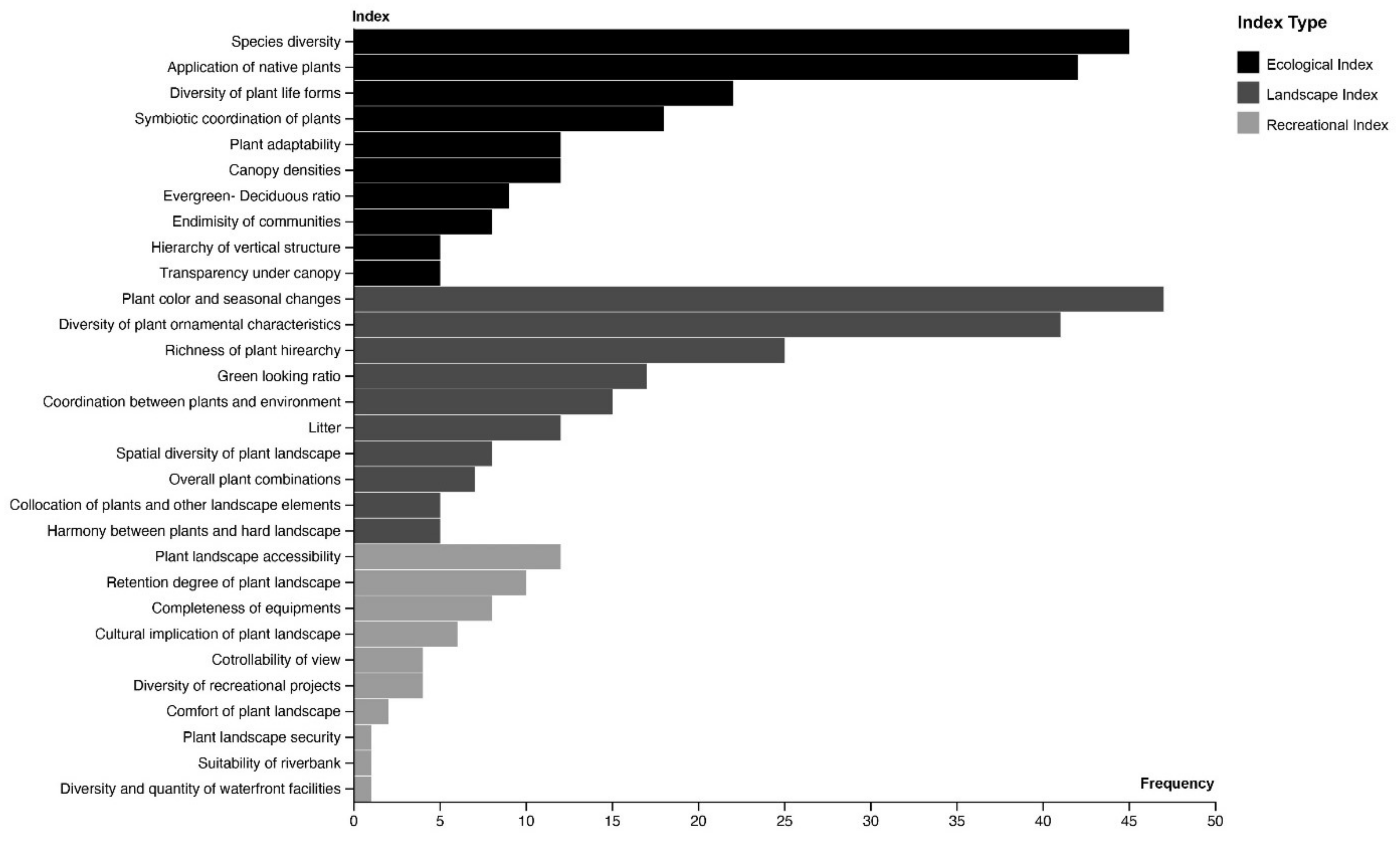
3.1.1. Determining the Evaluation Indicators
3.1.2. Establishment of Index Value and Ranking Standard
3.1.3. Determining the Weights of Evaluation Indicators
3.2. Establishment of Evaluation Model
4. Results and Analysis
4.1. Evaluation of Riparian Landscape
4.2. Evaluation Results
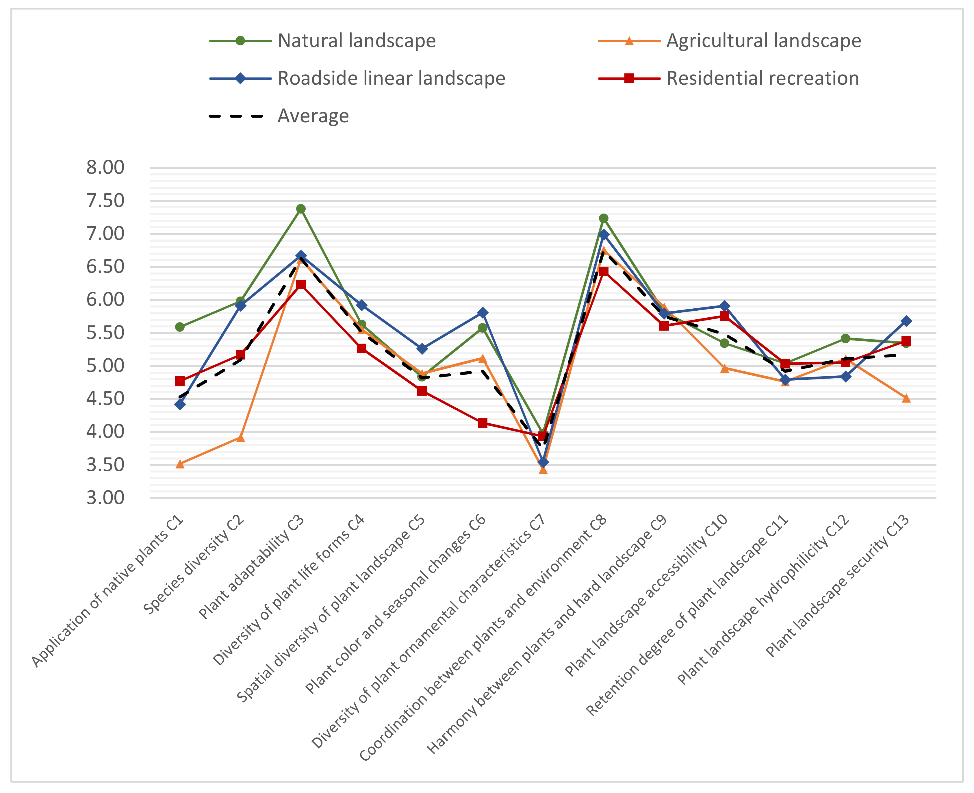
4.3. Analysis
4.3.1. Overall Evaluation
4.3.2. Vegetation Characteristics Analysis
4.4. Suggestions on Improving the Rural River Landscape in Qingxi Area
4.4.1. Increasing Vegetation Diversity
4.4.2. Choosing Native and Culturally Representative Species
4.4.3. Improving Waterfront Planting Design
4.4.4. Achieving Ecological Riverbank Construction
4.4.5. Building a Greenway System and Recreational Space
5. Discussion and Conclusions
Author Contributions
Funding
Data Availability Statement
Conflicts of Interest
References
- Sender, J. Differentiation of the vegetation of the Szum river (Central Roztocze). In Annales Universitatis Mariae Curie-Sklodowska; Maria Curie-Skłodowska University: Lublin, Poland, 2008; Volume 63, p. 71. [Google Scholar]
- Dybkjaer, J.B.; Baattrup-Pedersen, A.; Kronvang, B.; Thodsen, H. Diversity and distribution of riparian plant communities in relation to stream size and eutrophication. J. Environ. Qual. 2012, 41, 348–354. [Google Scholar] [CrossRef] [PubMed]
- Garssen, A.G.; Baattrup-Pedersen, A.; Voesenek, L.A.; Verhoeven, J.T.; Soons, M.B. Riparian plant community responses to increased flooding: A meta-analysis. Global Chang. Biol. 2015, 21, 2881–2890. [Google Scholar] [CrossRef] [PubMed]
- Yang, S. Plant allocation model of rural river bank landscape in Hangzhou. Fujian For. Sci. Technol. 2016, 43, 234–237. [Google Scholar]
- Su, G.; Chen, F.; Bao, M. Analysis on plant contraposition allocation mode in river ecological construction in Beijing. Soil Water Conserv. China 2019, 5, 34–37. [Google Scholar]
- Dong, J. Study on urban river ecosystem construction and plant allocation optimization method. Green Technol. 2016, 23, 17–18. [Google Scholar]
- Maseyk, F.J.F.; Dominati, E.J.; White, T.; Mackay, A.D. Farmer perspectives of the on-farm and off-farm pros and cons of planted multifunctional riparian margins. Land Use Policy 2017, 61, 160–170. [Google Scholar] [CrossRef]
- Burton, M.L.; Samuelson, L.J.; Mackenzie, M.D. Riparian woody plant traits across an urban-rural land use gradient and implications for watershed function with urbanization. Landsc. Urban Plan. 2009, 90, 42–55. [Google Scholar] [CrossRef]
- Tsai, C.-W.; Young, T.; Warren, P.H.; Maltby, L. Riparian thermal conditions across a mixed rural and urban landscape. Appl. Geogr. 2017, 87, 106–114. [Google Scholar] [CrossRef]
- Oleson, K.W.; Monaghan, A.; Wilhelmi, O.; Barlage, M.; Brunsell, N.; Feddema, J.; Hu, L.; Steinhoff, D. Interactions between urbanization, heat stress, and climate change. Clim. Chang. 2015, 129, 525–541. [Google Scholar] [CrossRef]
- Groffman, P.M.; Bain, D.J.; Band, L.E.; Belt, K.T.; Brush, G.S.; Grove, J.M.; Pouyat, R.V.; Yesilonis, I.C.; Zipperer, W.C. Down by the riverside: Urban riparian ecology. Front. Ecol. Environ. 2003, 1, 315–321. [Google Scholar] [CrossRef]
- de Souza, A.L.T.; Fonseca, D.G.; Libório, R.A.; Tanaka, M.O. Influence of riparian vegetation and forest structure on the water quality of rural low-order streams in SE Brazil. For. Ecol. Manag. 2013, 298, 12–18. [Google Scholar] [CrossRef]
- Alam, G.M.M.; Alam, K.; Mushtaq, S.; Filho, W.L. How do climate change and associated hazards impact on the resilience of riparian rural communities in Bangladesh? Policy implications for livelihood development. Environ. Sci. Policy 2018, 84, 7–18. [Google Scholar] [CrossRef]
- Folke, C. Resilience: The emergence of a perspective for social–ecological systems analyses. Glob. Environ. Chang. 2006, 16, 253–267. [Google Scholar] [CrossRef]
- Shanghai Municipal People’s Government. Notice of Shanghai Municipal People’s Government on Printing and Distributing and the 14th Five-Year Plan for Rural Revitalization in Shanghai. Available online: https://www.shanghai.gov.cn/nw12344/20210720/046782b10d2145c0b201c41aca762196.html (accessed on 21 April 2021).
- Shanghai Municipal People’s Government. Overall Urban Planning of Shanghai (2017–2035). Available online: https://www.shanghai.gov.cn/nw42806/index.html (accessed on 16 May 2018).
- Cole, L.J.; Stockan, J.; Helliwell, R. Managing riparian buffer strips to optimise ecosystem services: A review. Agric. Ecosyst. Environ. 2020, 296, 106891. [Google Scholar] [CrossRef]
- Shanghai Municipal People’s Government. Notice of Shanghai Municipality on Printing and Distributing the Medium and Long Term Development Plan of Dianshan Lake Area (Full Text). Available online: http://district.ce.cn/zt/zlk/wj/201308/21/t20130821_24679511.shtml (accessed on 21 August 2013).
- Lei, F. Study on landscape plant evaluation based on SD method—Taking Xiangsihu campus of Guangxi University of finance and economics as an example. J. Shandong Agric. Univ. 2020, 51, 858–862. [Google Scholar]
- Zou, W.; Hu, X.; Cheng, L. Plant landscape evaluation of road green space in Shanghang County. J. Northwest For. Coll. 2020, 35, 265–272. [Google Scholar]
- Yang, T.; Wang, X.; Zhang, Q. Study on plant landscape evaluation of mountain park based on landscape suitability—Taking Qianling Mountain Park in Guiyang as an example. Chin. Gard. 2020, 36, 117–121. [Google Scholar]
- Liu, L. Study on spatial distribution characteristics and evaluation of rural settlement landscape in Hunan Province. Agric. Resour. Reg. China 2020, 41, 284–289. [Google Scholar]
- Yang, Y.; Tang, X.; Liu, L.A.N. Evaluation of plant landscape quality in Nanjing based on principal component method and beauty degree method—A case study of 6 university campuses. J. Northwest For. Coll. 2020, 35, 256–264. [Google Scholar]
- Kang, X. Plant landscape evaluation of 8 parks in Guilin based on AHP method. J. Northwest For. Coll. 2018, 33, 273–278. [Google Scholar]
- Zhe, Z.; Huitang, P. Research on the evaluation of garden plant landscapes. J. Zhejiang A F Univ. 2011, 28, 926–967. [Google Scholar]
- Dindaroglu, T. Determination of ecological networks for vegetation connectivity using GIS & AHP technique in the Mediterranean degraded karst ecosystems. J. Arid. Environ. 2021, 188, 104385. [Google Scholar]
- Li, G.; Li, Y. Optimization spatial pattern method for vegetation landscape in bay based on AHP. Microprocess. Microsyst. 2021, 83, 104041. [Google Scholar] [CrossRef]
- Lifang, Q.; Yichuan, Z.; Wei, C. Evaluation of urban river landscape design rationality based on AHP. Water Sci. Eng. 2008, 1, 75–81. [Google Scholar]
- Wang, B.; Xie, H.-L.; Ren, H.-Y.; Li, X.; Chen, L.; Wu, B.-C. Application of AHP, TOPSIS, and TFNs to plant selection for phytoremediation of petroleum-contaminated soils in shale gas and oil fields. J. Clean. Prod. 2019, 233, 13–22. [Google Scholar] [CrossRef]
- Ebrahimabadi, A. Selecting proper plant species for mine reclamation using fuzzy AHP approach (case study: Chadormaloo iron mine of Iran). Arch. Min. Sci. 2016, 61. [Google Scholar] [CrossRef]
- Jayawickrama, H.M.M.M.; Kulatunga, A.K.; Mathavan, S. Fuzzy AHP based Plant Sustainability Evaluation Method. Procedia Manuf. 2017, 8, 571–578. [Google Scholar] [CrossRef]
- Wang, L.H. Plant landscape design simulating natural community by using AHP method based on TWINSPAN classification. In AIP Conference Proceedings; AIP Publishing LLC: New York, NY, USA, 2018; p. 030010. [Google Scholar]
- Zhang, X. The Optimization of spatial art pattern of vegetation landscape in the bay area. J. Coast. Res. 2020, 103, 1051–1055. [Google Scholar] [CrossRef]
- Cram, S.; Sommer, I.; Morales, L.-M.; Oropeza, O.; Carmona, E.; González-Medrano, F. Suitability of the vegetation types in Mexico’s Tamaulipas state for the siting of hazardous waste treatment plants. J. Environ. Manag. 2006, 80, 13–24. [Google Scholar] [CrossRef]
- Dai, H.; Xiong, X.; Zhang, X.; Chen, K. The Comprehensive Evaluation of Slope Vegetation Based on AHP and Fuzzy Math Method. In Proceedings of the 2012 International Conference on Fuzzy Theory and Its Applications (iFUZZY2012), Taichung, Taiwan, 16–18 November 2012; pp. 374–378. [Google Scholar]
- Yang, N.; Chen, L.; Sepahvand, K.; Yi, H.; Marburg, S. Structural-acoustic optimization based on fast multipole boundary element method sensitivity analysis of a coupled acoustic fluid-structure system. J. Acoust. Soc. Am. 2017, 141, 3513. [Google Scholar] [CrossRef]
- Shen, X.; Handel, S.N.; Kirkwood, N.G.; Huang, Y.; Padua, M.G. Locating the responsive plants for landscape recovery: A toolkit for designers and planners. Ecol. Restor. 2022, 40, 33–35. [Google Scholar] [CrossRef]
- Nighswander, G.P.; Sinclair, J.S.; Dale, A.G.; Qiu, J.; Iannone, B.V. Importance of plant diversity and structure for urban garden pest resistance. Landsc. Urban Plan. 2021, 215, 104211. [Google Scholar] [CrossRef]
- Nassauer, J.I. Messy ecosystems, orderly frames. Landsc. J. 1995, 14, 161–170. [Google Scholar] [CrossRef]
- Fischer, A.; Selge, S.; Van Der Wal, R.; Larson, B.M. The public and professionals reason similarly about the management of non-native invasive species: A quantitative investigation of the relationship between beliefs and attitudes. PLoS ONE 2014, 9, e105495. [Google Scholar]
- Peterson, M.N.; Thurmond, B.; McHale, M.; Rodriguez, S.; Bondell, H.D.; Cook, M. Predicting native plant landscaping preferences in urban areas. Sustain. Cities Soc. 2012, 5, 70–76. [Google Scholar] [CrossRef]
- Alam, H.; Khattak, J.Z.K.; Ppoyil, S.B.T.; Kurup, S.S.; Ksiksi, T.S. Landscaping with native plants in the UAE: A review. Emir. J. Food Agric. 2017, 29, 729–741. [Google Scholar] [CrossRef]
- Gillis, A.J.; Swim, J.K. Adding native plants to home landscapes: The roles of attitudes, social norms, and situational strength. J. Environ. Psychol. 2020, 72, 101519. [Google Scholar] [CrossRef]
- Tockner, K.; Stanford, J.A. Riverine flood plains: Present state and future trends. Environ. Conserv. 2002, 29, 308–330. [Google Scholar] [CrossRef]
- Cavaillé, P.; Ducasse, L.; Breton, V.; Dommanget, F.; Tabacchi, E.; Evette, A. Functional and taxonomic plant diversity for riverbank protection works: Bioengineering techniques close to natural banks and beyond hard engineering. J. Environ. Manag. 2015, 151, 65–75. [Google Scholar] [CrossRef]
- Shen, X.; Chen, M.; Ge, M.; Padua, M.G. Examining the conceptual model of potential urban development patch (PUDP), VOCs, and food culture in urban ecology: A case in Chengdu, China. Atmosphere 2022, 13, 1369. [Google Scholar] [CrossRef]
- Kitchen, L.; Marsden, T. Creating sustainable rural development through stimulating the eco-economy: Beyond the eco-economic paradox? Sociol. Rural. 2009, 49, 273–294. [Google Scholar] [CrossRef]

| Village Name | Quadrat Quantity | Quadrat Number |
|---|---|---|
| Ye Gang | 8 | 01#–08# |
| Zheng Pu | 12 | 09#–20# |
| Wang Jin | 14 | 21#–34# |
| Dong She | 10 | 35#–44# |
| Shuang Xiang | 6 | 45#–50# |
| Chen Dong | 6 | 51#–56# |
| Cen Bu | 10 | 57#–66# |
| Patriotic | 7 | 67#–73# |
| Ai Guo | 9 | 74#–82# |
| Li Zhuang | 9 | 83#–91# |
| Riparian Landscape Types | Surrounding Environment and Plant Landscape Characteristics | Schematic Diagram of the Area where the Quadrat is Located | Number/Proportion of Classified Quadrats | |
|---|---|---|---|---|
| 1 | Natural landscape | The ecological benefits and visual effects of plants in the plots that have not been interfered by human activities for a long time are uneven. |  | 18/19.8% |
| 2 | Residential recreation landscape | Located in the rural settlements near the water, the general plant landscape has both ornamental and recreational functions. | 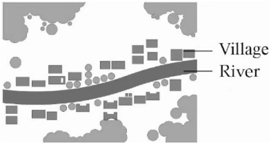 | 35/38.5% |
| 3 | Roadside linear landscape | The plant landscape is located between the road near the water and the river, which generally presents a linear landscape corridor. | 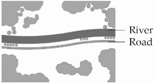 | 13/14.2% |
| 4 | Agricultural landscape | Riverside plants are staggered with farmland, fish ponds and economic forests, and the plant landscape has the characteristics of field scenery. |  | 25/27.5% |
| Level | Meaning |
|---|---|
| 1 | Comparing indicator i and j, i is as important as j |
| 3 | Comparing indicator i and j, i is a little more important than j |
| 5 | Comparing indicator i and j, i is obviously more important than j |
| 7 | Comparing indicator i and j, i is strongly more important than j |
| 9 | Comparing indicator i and j, i is extremely more important than j |
| 2, 4, 6, 8 | Indicates the intermediate value of the above level |
| CR Test | A-B | B1-C | B2-C | B3-C |
|---|---|---|---|---|
| value | 0.0279 | 0.0398 | 0.0846 | 0.0699 |
| Target Layer A (Weight) | Criterion Layer B (Weight) | Indicator Layer C (Weight) | Weight Ranking | Indicator Property |
|---|---|---|---|---|
| Evaluation of riparian landscape in rural Qingxi area (1.0) | Ecological capacity B1 (0.4806) | Application of native plants C1(0.0272) | 9 | Quantitative |
| Species diversity C2(0.0988) | 4 | Quantitative | ||
| Plant adaptability C3(0.2782) | 1 | Quantitative | ||
| Diversity of plant life forms C4(0.0765) | 5 | Quantitative | ||
| Landscape aesthetics B2 (0.4054) | Spatial diversity of plant landscape C5(0.1692) | 2 | Quantitative | |
| Plant color and seasonal changes C6(0.109) | 3 | Quantitative | ||
| Diversity of plant ornamental characteristics C7(0.0702) | 6 | Quantitative | ||
| Coordination between plants and environment C8(0.0328) | 8 | Qualitative | ||
| Harmony between plants and hard landscape C9(0.0241) | 11 | Qualitative | ||
| Social service B3 (0.1140) | Plant landscape accessibility C10(0.0189) | 12 | Qualitative | |
| Retention degree of plant landscape C11(0.0244) | 10 | Quantitative | ||
| Plant landscape hydrophilicity C12(0.0073) | 13 | Qualitative | ||
| Plant landscape security C13(0.0633) | 7 | Qualitative |
| Quadrat | Ecological Capacity | Landscape Aesthetics | Social Service | CEI (%) | CEI Level |
|---|---|---|---|---|---|
| 01# | 3.73 | 1.98 | 0.49 | 62.23 | Ⅲ |
| 02# | 3.68 | 1.84 | 0.84 | 63.74 | Ⅲ |
| 03# | 2.71 | 2.28 | 0.58 | 55.86 | Ⅲ |
| 04# | 2.99 | 2.05 | 0.51 | 55.62 | Ⅲ |
| 05# | 2.29 | 2.04 | 0.45 | 47.98 | Ⅳ |
| 06# | 2.96 | 1.95 | 0.45 | 53.79 | Ⅳ |
| 07# | 3.27 | 2.41 | 0.53 | 62.26 | Ⅲ |
| 08# | 2.33 | 1.72 | 0.32 | 43.83 | Ⅳ |
| 09# | 3.38 | 2.06 | 0.53 | 59.92 | Ⅲ |
| 10# | 3.22 | 2.51 | 0.63 | 63.77 | Ⅲ |
| 11# | 3.13 | 1.7 | 0.64 | 54.90 | Ⅳ |
| 12# | 3.05 | 2.22 | 0.59 | 58.79 | Ⅲ |
| 13# | 3.08 | 2.37 | 0.77 | 62.35 | Ⅲ |
| 14# | 2.75 | 1.55 | 0.81 | 51.34 | Ⅳ |
| 15# | 2.14 | 2.42 | 0.61 | 51.80 | Ⅳ |
| 16# | 3.35 | 2.11 | 0.63 | 61.03 | Ⅲ |
| 17# | 3.1 | 1.77 | 0.58 | 54.60 | Ⅳ |
| 18# | 2.47 | 2.09 | 0.28 | 48.54 | Ⅳ |
| 19# | 2.83 | 2.07 | 0.7 | 56.13 | Ⅲ |
| 20# | 2.44 | 2.07 | 0.62 | 51.45 | Ⅳ |
| 21# | 2.32 | 2.22 | 0.65 | 52.02 | Ⅳ |
| 22# | 2.87 | 1.89 | 0.48 | 52.49 | Ⅳ |
| 23# | 3.09 | 1.85 | 0.48 | 54.42 | Ⅳ |
| 24# | 2.21 | 1.26 | 0.6 | 40.84 | Ⅳ |
| 25# | 3.32 | 2.56 | 0.59 | 64.89 | Ⅲ |
| 26# | 2.78 | 1.71 | 0.71 | 52.18 | Ⅳ |
| 27# | 2.39 | 2.02 | 0.6 | 50.25 | Ⅳ |
| 28# | 2.73 | 1.27 | 0.79 | 48.10 | Ⅳ |
| 29# | 2.84 | 1.77 | 0.59 | 52.12 | Ⅳ |
| 30# | 2.8 | 2.41 | 0.42 | 56.46 | Ⅲ |
| 31# | 2.92 | 1.9 | 0.49 | 53.24 | Ⅳ |
| 32# | 1.91 | 0.71 | 0.47 | 31.10 | Ⅴ |
| 33# | 2.71 | 1.96 | 0.39 | 50.71 | Ⅳ |
| 34# | 3.61 | 2.36 | 0.86 | 68.46 | Ⅲ |
| 35# | 3.82 | 2.48 | 0.57 | 68.77 | Ⅲ |
| 36# | 2.81 | 2.5 | 0.66 | 59.78 | Ⅲ |
| 37# | 2.79 | 1.48 | 0.57 | 48.60 | Ⅳ |
| 38# | 2.84 | 1.28 | 0.61 | 47.47 | Ⅳ |
| 39# | 3.37 | 2.18 | 0.65 | 62.15 | Ⅲ |
| 40# | 3.19 | 2.37 | 0.66 | 62.31 | Ⅲ |
| 41# | 2.08 | 0.99 | 0.35 | 34.29 | Ⅴ |
| 42# | 1.67 | 2.28 | 0.3 | 42.62 | Ⅳ |
| 43# | 1.89 | 1.26 | 0.57 | 37.41 | Ⅴ |
| 44# | 2.28 | 2.5 | 0.66 | 54.47 | Ⅳ |
| 45# | 1.74 | 2.25 | 0.4 | 43.97 | Ⅳ |
| 46# | 1.82 | 2.16 | 0.62 | 46.19 | Ⅳ |
| 47# | 2.24 | 0.64 | 0.44 | 33.40 | Ⅴ |
| 48# | 2.5 | 2.25 | 0.47 | 52.27 | Ⅳ |
| 49# | 3.27 | 2.04 | 0.39 | 57.16 | Ⅲ |
| 50# | 2.85 | 2.33 | 0.7 | 58.98 | Ⅲ |
| 51# | 2.48 | 2.08 | 0.49 | 50.70 | Ⅳ |
| 52# | 2.82 | 2.3 | 0.38 | 55.17 | Ⅲ |
| 53# | 2.57 | 2.54 | 0.5 | 56.23 | Ⅲ |
| 54# | 3.63 | 2.33 | 0.58 | 65.54 | Ⅲ |
| 55# | 2.69 | 1.93 | 0.62 | 52.63 | Ⅳ |
| 56# | 3.12 | 2.15 | 0.62 | 59.01 | Ⅲ |
| 57# | 3.97 | 2.66 | 0.65 | 72.89 | Ⅱ |
| 58# | 3.06 | 1.71 | 0.67 | 54.56 | Ⅳ |
| 59# | 3.04 | 2.07 | 0.81 | 59.41 | Ⅲ |
| 60# | 3.49 | 2.09 | 0.9 | 64.93 | Ⅲ |
| 61# | 2.97 | 1.47 | 0.56 | 50.17 | Ⅳ |
| 62# | 2.52 | 2.05 | 0.66 | 52.47 | Ⅳ |
| 63# | 2.58 | 1.7 | 0.51 | 47.95 | Ⅳ |
| 64# | 3.01 | 1.94 | 0.55 | 55.11 | Ⅲ |
| 65# | 3.82 | 2.26 | 0.81 | 69.00 | Ⅲ |
| 66# | 2.42 | 2.16 | 0.67 | 52.64 | Ⅳ |
| 67# | 3.02 | 2.08 | 0.63 | 57.50 | Ⅲ |
| 68# | 2.73 | 2.4 | 0.71 | 58.64 | Ⅲ |
| 69# | 2.8 | 1.94 | 0.72 | 54.73 | Ⅳ |
| 70# | 3.2 | 1.93 | 0.39 | 55.38 | Ⅲ |
| 71# | 3.14 | 1.5 | 0.46 | 51.12 | Ⅳ |
| 72# | 2.94 | 2.06 | 0.51 | 55.27 | Ⅲ |
| 73# | 2.45 | 2.14 | 0.74 | 53.43 | Ⅳ |
| 74# | 3.52 | 2.23 | 0.46 | 62.14 | Ⅲ |
| 75# | 2.99 | 1.98 | 0.55 | 55.38 | Ⅲ |
| 76# | 3.69 | 2.08 | 0.6 | 63.91 | Ⅲ |
| 77# | 2.78 | 1.42 | 0.47 | 46.86 | Ⅳ |
| 78# | 3.15 | 2.36 | 0.61 | 61.40 | Ⅲ |
| 79# | 3.81 | 2.26 | 0.44 | 65.22 | Ⅲ |
| 80# | 3.15 | 2.08 | 0.55 | 57.88 | Ⅲ |
| 81# | 3.02 | 2.36 | 0.5 | 58.92 | Ⅲ |
| 82# | 3.41 | 0.44 | 0.76 | 46.21 | Ⅳ |
| 83# | 3.28 | 1.33 | 0.72 | 53.51 | Ⅳ |
| 84# | 3.27 | 1.96 | 0.82 | 60.64 | Ⅲ |
| 85# | 2.89 | 1.85 | 0.68 | 54.27 | Ⅳ |
| 86# | 2.38 | 1.81 | 0.58 | 47.85 | Ⅳ |
| 87# | 2.35 | 2.05 | 0.7 | 51.14 | Ⅳ |
| 88# | 3.14 | 2.46 | 0.57 | 61.80 | Ⅲ |
| 89# | 3.36 | 2.58 | 0.62 | 65.63 | Ⅲ |
| 90# | 2.79 | 0.86 | 0.49 | 41.52 | Ⅳ |
| 91# | 2.81 | 1.87 | 0.54 | 52.40 | Ⅳ |
| Quadrat | CEIAverage Value(%) | CEI Grade | Ⅰ (85–100%) | Ⅱ (70–85%) | Ⅲ (55–70%) | Ⅳ (40–55%) | Ⅴ (<40%) | Total |
|---|---|---|---|---|---|---|---|---|
| Grade Definition | Excellent | Good | Medium | Poor | Very Poor | |||
| All quadrats | 54.60 | Number of samples (PCs) | 0 | 1 | 42 | 44 | 4 | 91 |
| Proportion (%) | 0 | 1.10 | 46.15 | 48.35 | 4.40 | 100 | ||
| Natural landscape | 59.11 | Number of samples (PCs) | 0 | 0 | 13 | 5 | 0 | 18 |
| Proportion (%) | 0 | 0 | 72.22 | 27.78 | 0 | 100 | ||
| Agricultural landscape | 52.73 | Number of samples (PCs) | 0 | 0 | 17 | 8 | 0 | 25 |
| Proportion (%) | 0 | 0 | 68.00 | 32.00 | 0 | 100 | ||
| Roadside linear landscape | 57.78 | Number of samples (PCs) | 0 | 0 | 8 | 5 | 0 | 13 |
| Proportion (%) | 0 | 0 | 61.54 | 38.46 | 0 | 100 | ||
| Residential recreation landscape | 52.42 | Number of samples (PCs) | 0 | 1 | 13 | 17 | 4 | 35 |
| Proportion (%) | 0 | 2.86 | 37.14 | 48.57 | 11.43 | 100 |
| Strategies | Method | Goal |
|---|---|---|
| Increasing Vegetation Diversity | Using more species in a reasonable way; create more effective plant communities. | Enhance ecological resilience; increase biodiversity; improve ornamental characteristics. |
| Choosing Native and Culturally Representative Species | Increase the proportion of native plants. | Improve natural and cultural. Improve geographical identifiability; making plants and communities more adaptable to the local environment. |
| Achieving Ecological Riverbank Construction | Utilizing bioengineering approaches; using a more naturalized shape. | Reduce surface runoff and protect water bodies; provide more diverse habitats for animals, plants, microorganisms, etc. |
| Improving Waterfront Planting Design | Make full use of the gentle slope of a riverside; protect existing wetland; create more space for vegetations. | Improve the diversity of waterfront plant communities; purify water bodies; restore ecological environment |
| Building a Greenway System and Recreational Space | Connect riverside trails with the greenway system; recreational spaces; low-impact development. | Enhance rural attractiveness; create economic, social and environment benefits. |
| Ecological Restoration Plant | Landscape Aesthetics Plants | Ecological and Economical Friendly Plants | |
|---|---|---|---|
| Evergreen Canopy | Cinnamomum septentrionale, Eriobotrya japonica, Ligustrum lucidum, Pinus elliottii, Castanopsis sclerophylla, Quercus glauca, Osmanthus fragrans, Phyllostachys heteroclada, Cyperus alternifolius, Phyllostachys sulphurea var. viridis, Bambusa textilis | Cinnamomum septentrionale, Ligustrum lucidum, Osmanthus fragrans, Trachycarpus fortunei, Ilex rubra | Phyllostachys violascens, Phyllostachys violascens cv. Prevernalis, Phyllostachys edulis, Eriobotrya japonica, Citrus medica, Citrus maxima |
| Deciduous Canopy | Salix babylonica, Salix rosthornii, Taxodium distichum, Metasequoia glyptostroboides, ×Taxodiomera peizhongii, Taxodium distichum var. imbricatum, Pterocarya stenoptera, Ficus carica, Poncirus trifoliata, Celtis sinensis, Zelkova serrata, Ailanthus altissima, Toona sinensis, Melia azedarach, Triadica sebifera, Firmiana simplex, Diospyros kaki, Paulownia fortunei, Euonymus maackii, Acer palmatum, Camptotheca acuminata | Celtis sinensis, Zelkova serrata, Acer buergerianum, Albizia julibrissin, Triadica sebifera, Metasequoia glyptostroboides, Taxodium distichum var. imbricatum, Taxodium distichum, ×Taxodiomera peizhongii, Rhus chinensis, Euonymus maackii, Staphylea forrestii, Melia azedarach | Morus alba, Maclura tricuspidata, Prunus persica, Toona sinensis, Triadica sebifera, Vernicia fordii, Rhus chinensis, Toxicodendron succedaneum, Toxicodendron vernicifluum, Diospyros kaki, Paulownia fortunei |
| Evergreen Shrub | Ficus pumila, Senna spectabilis, Mucuna sempervirens, Citrus maxima, Citrus reticulata, Euonymus fortunei, Ilex cornuta, Ilex chinensis, Nerium oleander, Trachelospermum jasminoides, Adina pilulifera, Gardenia jasminoides, Bambusa multiplex, Indocalamus tessellatus | Nerium oleander, Adina pilulifera, Ligustrum sinense var. variegatum, Camellia sasanqua | Camellia oleifera, Poncirus trifoliata, Citrus reticulata |
| Deciduous Shrub | Chimonanthus praecox, Cercis chinensis, Amorpha fruticosa, Wisteria sinensis, Buddleja lindleyana, Hibiscus mutabilis, Celastrus orbiculatus, Tamarix chinensis, Hibiscus syriacus, Lagerstroemia indica, Rhododendron simsii, Forsythia suspensa, Vitex negundo var. cannabifolia, Adina rubella, Boehmeria nivea, Akebia trifoliata, Lespedeza thunbergii subsp. formosa | Chimonanthus praecox, Rosa multiflora, Hibiscus mutabilis, Malus halliana, Hibiscus hamabo, Lagerstroemia indica, Cercis chinensis, Wisteria sinensis, Rhododendron simsii, Forsythia viridissima, Vitex negundo var. cannabifolia, Hibiscus syriacus, Viburnum macrocephalum, Sambucus williamsii, Weigela florida | Pyrus spp, Ficus carica, Prunus salicina |
| Herb | Adiantum capillus-veneris, Aristolochia debilis, Persicaria orientalis, Phedimus aizoon, Toxicodendron radicans subsp. hispidum, Trifolium pratense, Trifolium repens, Malva cathayensis, Dichondra micrantha, Colocasia esculenta, Hemerocallis fulva, Ophiopogon bodinieri, Lycoris radiata, Iris lactea, Imperata cylindrica, Arundo donax, Miscanthus sinensis cv. Gracillimus, Pennisetum alopecuroides, Saccharum arundinaceum, Chrysopogon zizanioides, Zoysia japonica, Sedum sarmentosum, Eremochloa ophiuroides, Lolium perenne | Houttuynia cordata, Dichondra micrantha, Scutellaria barbata, Cirsium japonicum, Eremochloa ophiuroides, Hosta plantaginea, Hosta ventricosa, Cortaderia selloana cv. Pumila, Pennisetum alopecuroides, Miscanthus sinensis cv. Gracillimus, Zoysia japonica, Hemerocallis fulva, Ophiopogon bodinieri, Canna indica, Lycoris radiata, Saccharum arundinaceum, Iris tectorum | Hemerocallis fulva, Ophiopogon japonicus, Colocasia esculenta |
| Aquatic | Oenanthe javanica, Sagittaria trifolia subsp. leucopetala, Euryale ferox, Lythrum salicaria, Nymphoides peltata, Typha orientalis, Phragmites australis, Zizania latifolia, Schoenoplectus triqueter, Brasenia schreberi, Alisma plantago-aquatica, Arundo donax, Coix lacryma-jobi, Acorus calamus, Juncus setchuensis, Iris pseudacorus, Typha angustifolia, Canna indica, Ipomoea aquatica, Nelumbo nucifera, Thalia dealbata, Pontederia cordata, Schoenoplectus tabernaemontani, Juncus effusus, Myriophyllum verticillatum, Nymphoides lungtanensis, Nymphaea tetragona, Potamogeton wrightii, Ceratophyllum demersum, Hydrilla verticillata, Potamogeton crispus, Vallisneria natans | Thalia dealbata, Nelumbo nucifera, Nymphaea tetragona, Ceratophyllum demersum, Alopecurus pratensis, Arundo donax, Coix lacryma-jobi, Phragmites australis, Acorus calamus, Juncus effusus, Typha orientalis, Iris pseudacorus, Pontederia cordata, Lythrum salicaria | Sagittaria trifolia subsp. leucopetala, Trapa bispinosa, Nelumbo nucifera, Oenanthe javanica, Brasenia schreberi, Euryale ferox, Coix lacryma-jobi, Zizania latifolia |
| Planting Combination | Aquatic Plants (Below the Normal Water Level) | Normal Water Level to Flood Level | Above Flood Level | River Riparian | Applicable Riparian Landscape Type |
|---|---|---|---|---|---|
| Type 1 | Emerged Plants Typha orientalis | Canopy Metasequoia glyptostroboides Shrub Indigofera bungeana Herb Lythrum salicaria | Canopy Cinnamomum camphora Shrub Hibiscus mutabilis Herb Eremochloa ophiuroides | Canopy Cinnamomum camphora,Triadica sebifera Shrub Weigela florida Herb Eremochloa ophiuroides | Residential recreation, roadside linear landscape, agricultural landscape |
| Type 2 | Emerged Plants Cortaderia selloana | Canopy Salix rosthornii Shrub Lespedeza thunbergii subsp. Formosa Herb Persicaria orientalis | Canopy Ligustrum lucidum Shrub Amorpha fruticose Herb Cynodon dactylon | Canopy Melia azedarach Shrub Photinia serratifolia Herb Cynodon dactylon | Natural landscape, agricultural landscape |
| Type 3 | Swimming Plants Euryale ferox | Canopy Pinus elliottii Shrub Hibiscus mutabilis Herb Canna indica | Canopy Pterocarya stenoptera Shrub Hibiscus mutabilis Herb Zoysia japonica | Canopy Ligustrum lucidum Shrub Cercis chinensis Herb Zoysia japonica | Natural landscape, agricultural landscape |
| Type 4 | Emerged Plants Phragmites australis | Canopy Celtis sinensis Shrub Hibiscus mutabilis Herb Saccharum arundinaceum | Canopy Trachycarpus fortune Shrub Bambusa multiplex Herb Jasminum mesnyi | Canopy Salix babylonica Shrub Indocalamus tessellatus Herb Pennisetum alopecuroides | Natural landscape, agricultural landscape |
| Type 5 | Emerged Plants Typha angustifolia | Canopy Taxodium distichum Shrub Nerium oleander Herb Arundo donax cv. Versicolor | Canopy Koelreuteria bipinnata cv. Integrifoliola Shrub Nerium oleander Herb Canna indica | Canopy Cinnamomum septentrionale Herb Cynodon dactylon | Roadside linear landscape |
| Type 6 | Hydrophyte Herb Taxodium distichum var. imbricatum | Canopy Triadica sebifera Shrub Cercis chinensis Herb Lythrum salicaria | Canopy Liquidambar formosana Shrub Lagerstroemia indica Herb Ophiopogon japonicus | Canopy Liquidambar formosana Shrub Osmanthus fragrans Herb Cynodon dactylon | Natural landscape, agricultural landscape |
| Type 7 | Emerged Plants & Hydrophyte Herb Schoenoplectus tabernaemontani, Nelumbo nucifera | Canopy Celtis julianae Shrub Salix integra cv. Hakuro Nishiki Herb Pontederia cordata | Canopy Liquidambar formosana Shrub Gardenia jasminoides Herb Medicago sativa | Canopy Cornus kousa subsp. Chinensis Shrub Hypericum monogynum Herb Medicago sativa | Residential recreation |
| Type 8 | Hydrophyte Herb Iris pseudacorus | Canopy Salix babylonica Shrub Canna indica Herb Canna indica | Canopy Ligustrum lucidum Shrub Hibiscus syriacus, Malus halliana Herb Hemerocallis fulva | Canopy Ligustrum lucidum, Acer palmatum cv. Atropurpureum Shrub Hibiscus syriacus, Osmanthus fragrans Herb Hemerocallis fulva | Residential recreation |
| Type 9 | Emerged Plants Sagittaria trifolia subsp. Leucopetala, Nymphaea tetragona | Canopy Pterocarya stenoptera Shrub Hibiscus mutabilis Herb Lythrum salicaria | Canopy Melia azedarach Shrub Hibiscus hamabo Herb Miscanthus sinensis cv. Gracillimus | Canopy Eriobotrya japonica Shrub Weigela florida Herb Cynodon dactylon | Residential recreation |
| Type 10 | Emerged Plants Acorus calamus, Typha angustifoli, Cyperus alternifolius | Canopy ×Taxodiomera peizhongii Shrub Nerium oleander Herb Iris pseudacorus | Canopy Koelreuteria bipinnata cv. Integrifoliola Shrub Bambusa multiplex Herb Hemerocallis fulva | Canopy Sapindus Saponaria Shrub Lagerstroemia indica Herb Ophiopogon japonicus | Roadside linear landscape |
Publisher’s Note: MDPI stays neutral with regard to jurisdictional claims in published maps and institutional affiliations. |
© 2022 by the authors. Licensee MDPI, Basel, Switzerland. This article is an open access article distributed under the terms and conditions of the Creative Commons Attribution (CC BY) license (https://creativecommons.org/licenses/by/4.0/).
Share and Cite
Wang, L.; Ge, M.; Chen, N.; Ding, J.; Shen, X. An Evaluation Model of Riparian Landscape: A Case in Rural Qingxi Area, Shanghai. Land 2022, 11, 1512. https://doi.org/10.3390/land11091512
Wang L, Ge M, Chen N, Ding J, Shen X. An Evaluation Model of Riparian Landscape: A Case in Rural Qingxi Area, Shanghai. Land. 2022; 11(9):1512. https://doi.org/10.3390/land11091512
Chicago/Turabian StyleWang, Ling, Mengting Ge, Naiguang Chen, Jiahui Ding, and Xiwei Shen. 2022. "An Evaluation Model of Riparian Landscape: A Case in Rural Qingxi Area, Shanghai" Land 11, no. 9: 1512. https://doi.org/10.3390/land11091512
APA StyleWang, L., Ge, M., Chen, N., Ding, J., & Shen, X. (2022). An Evaluation Model of Riparian Landscape: A Case in Rural Qingxi Area, Shanghai. Land, 11(9), 1512. https://doi.org/10.3390/land11091512