Geological Heritage in the “Arribes del Duero” Natural Park (Western, Spain): A Case Study of Introducing Educational Information via Augmented Reality and 3D Virtual Itineraries
Abstract
1. Introduction
2. Geological Context
3. Materials and Methods
3.1. Assessment of Places of Geological Interest (LIGs) or Geosites
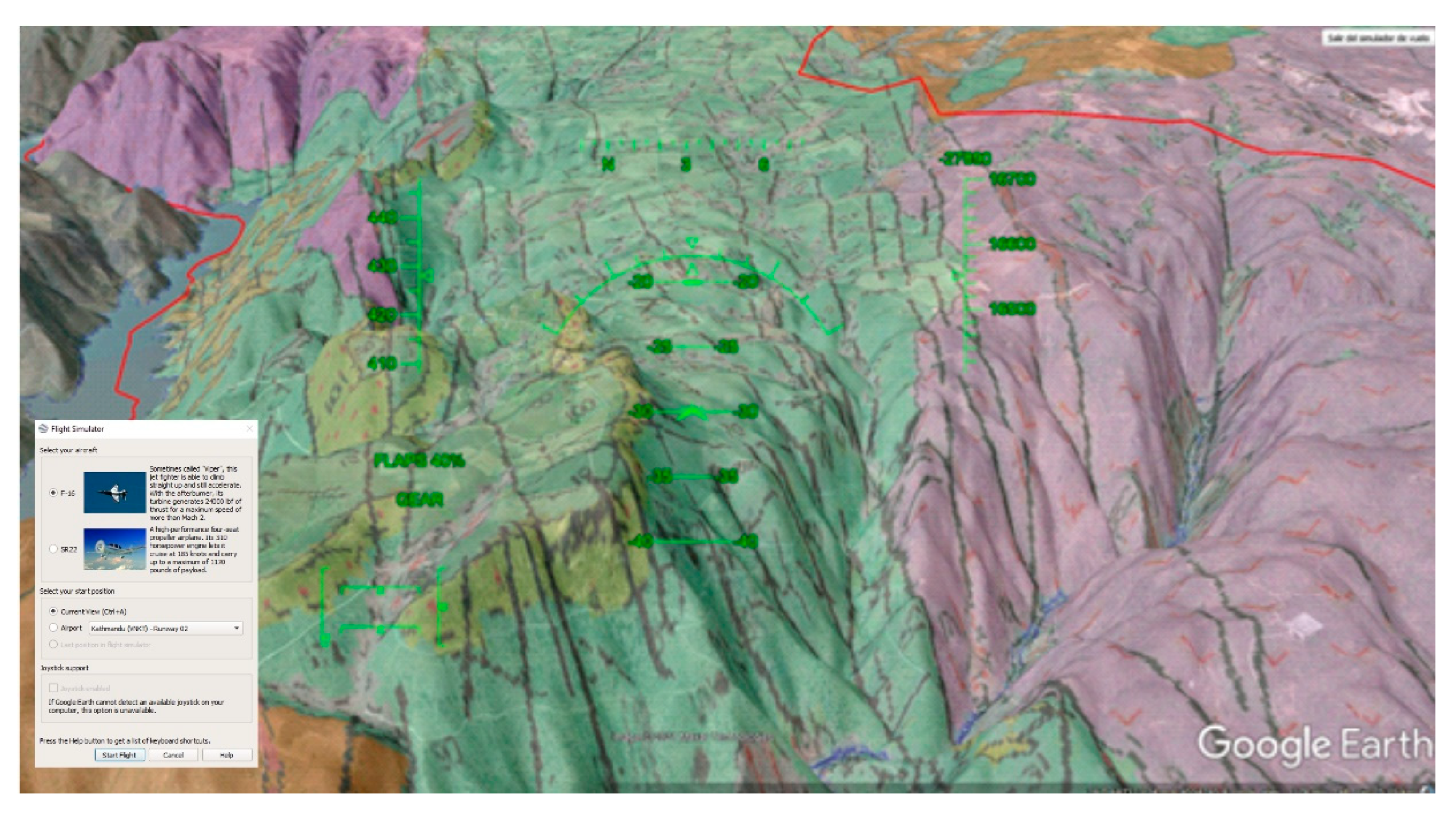
3.2. 3D Virtual Route on the Google Earth Platform
3.3. Educational Resources: Field Guide and Geoapp
4. Results
4.1. Itinerary and Geological Heritage
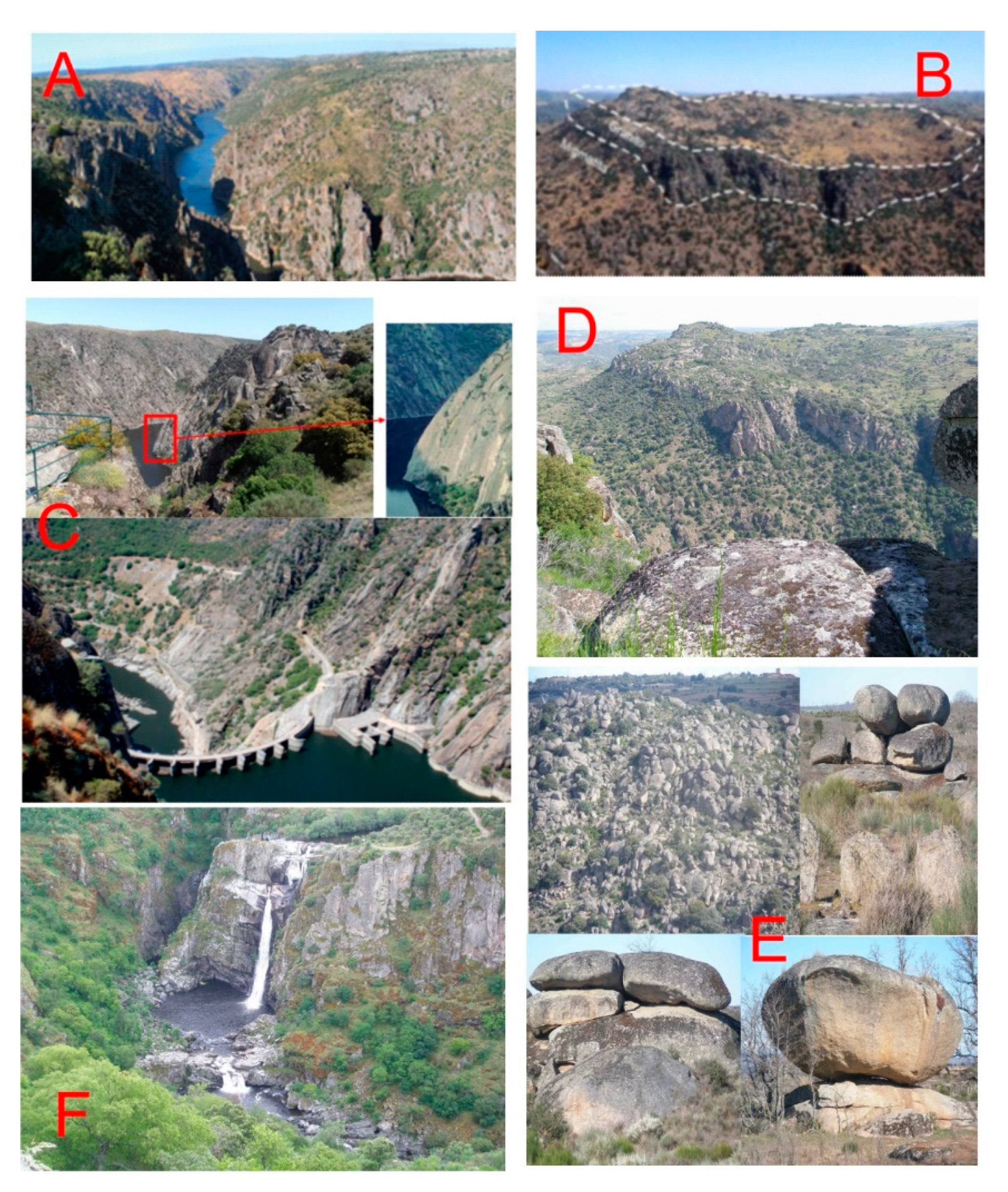
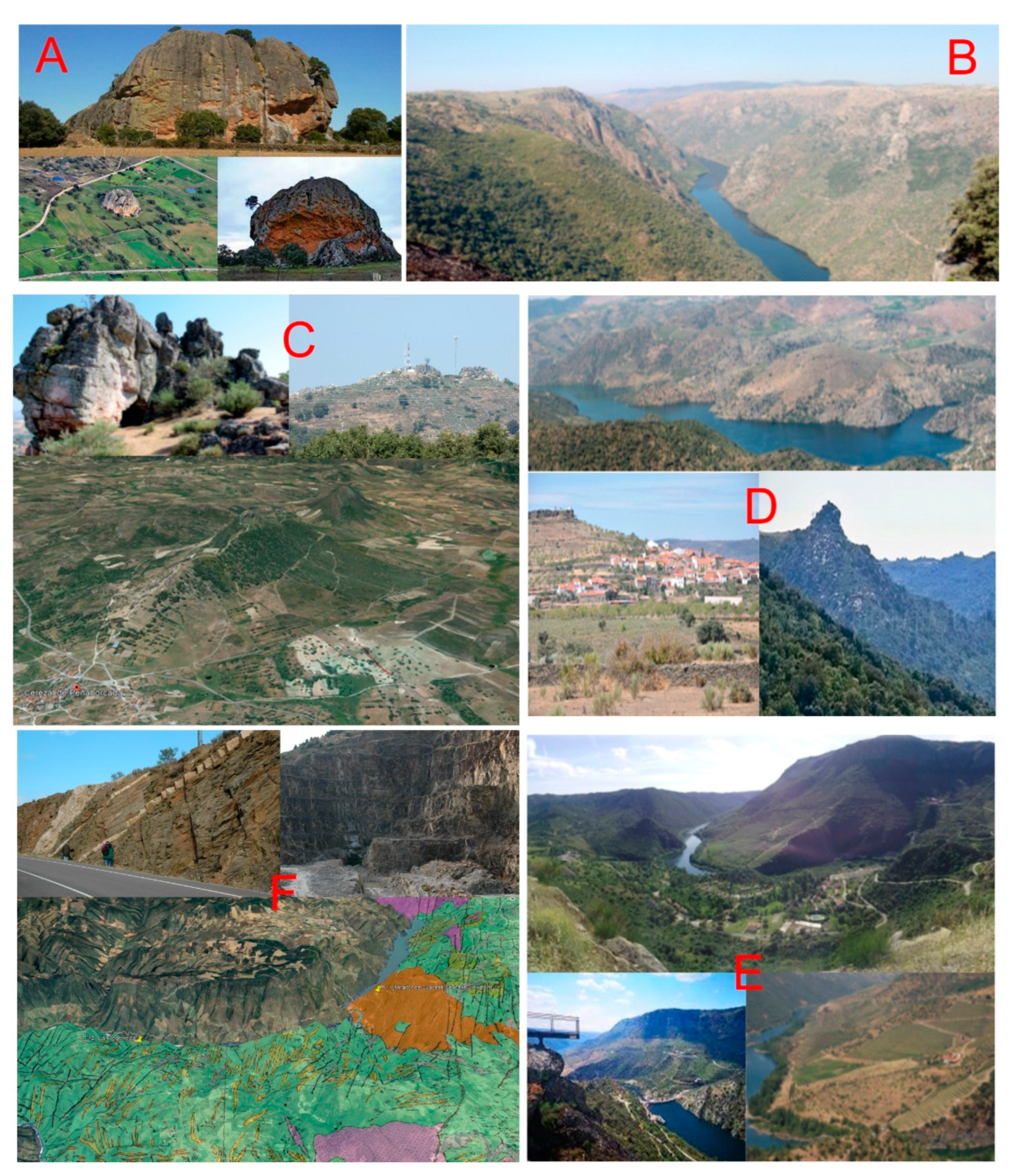
4.2. Description of the Stops
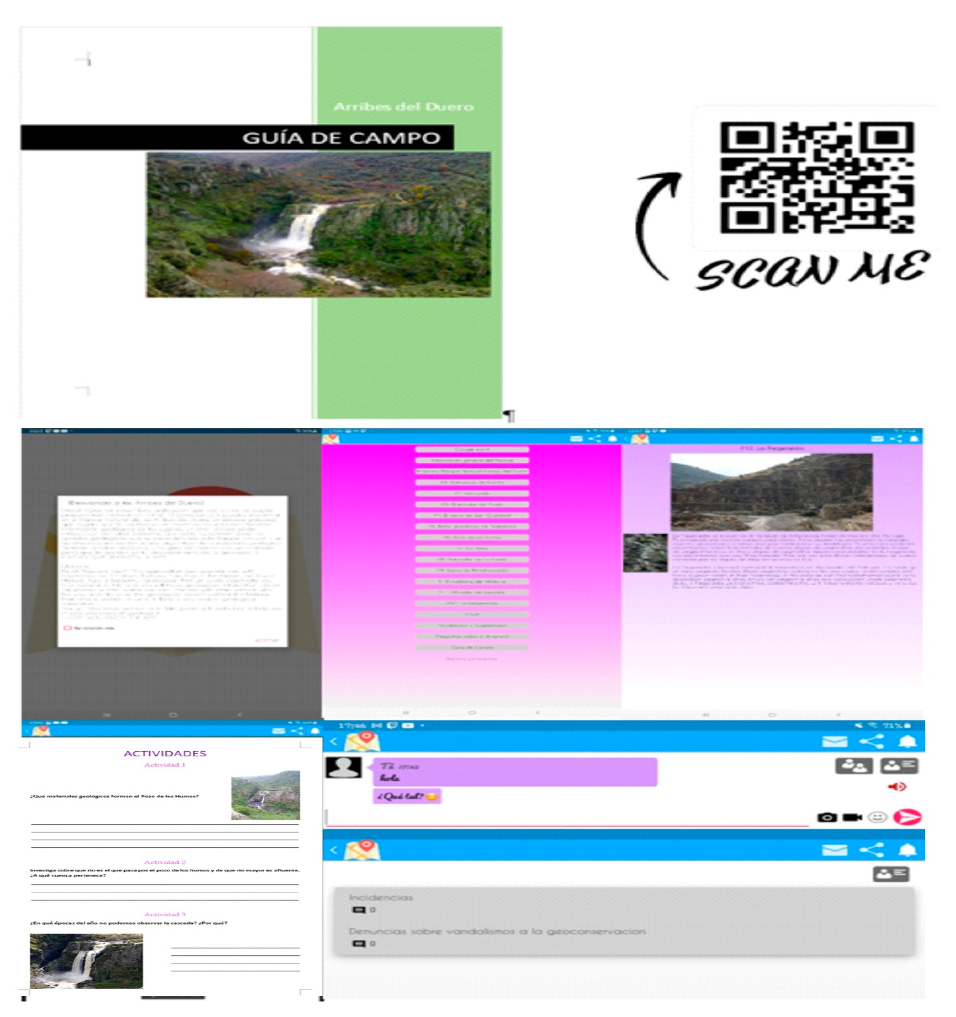
4.3. Didactic Resources
5. Conclusions
Supplementary Materials
Author Contributions
Funding
Institutional Review Board Statement
Informed Consent Statement
Acknowledgments
Conflicts of Interest
References
- Martínez-Graña, A.; Goy, J.L.; González-Delgado, J.A.; Cruz, R.; Sanz, J.; Bustamante, I. 3D Virtual itinerary in the Geological Heritage from Natural Parks in Salamanca-Ávila-Cáceres, Spain. Sustainability 2019, 11, 144. [Google Scholar] [CrossRef]
- Martínez-Graña, A.; Legoinha, P.; Goy, J.L.; González-Delgado, J.A.; Armenteros, I.; Dabrio, C.; Zazo, C. Geological-Geomorphological and Paleontological Heritage in the Algarve (Portugal) Applied to Geotourism and Geoeducation. Land 2021, 10, 918. [Google Scholar] [CrossRef]
- Goy, J.L.; Martínez-Graña, A.; González-Delgado, J.A.; Gonzalo-Corral, J.C.; Rufato, I.; Hernández-Barreña, D.; Legoinha, P. Moving towards a Geopark project in Southwest of Salamanca Province (Castilla y León, Spain). X Int. ProGEO Online Symp. 2021, 189–190. [Google Scholar]
- Alfonso, J.L.M.; Piedrabuena, M.Á.P.; Bergua, S.B.; Arenas, D.H. Geotourism Itineraries and Augmented Reality in the Geomorphosites of the Arribes del Duero Natural Park (Zamora Sector, Spain). Geoheritage 2021, 13, 16. [Google Scholar] [CrossRef]
- Zouros, N. The European Geoparks Network. Geological heritage protection and regional development. Episodes 2004, 27, 165–171. [Google Scholar] [CrossRef]
- Farsani, N.T.; Coelho, C.; Costa, C. Geotourism and geoparks as novel strategies for socio-economic development in rural areas. Int. J. Tour. Res. 2011, 13, 68–81. [Google Scholar] [CrossRef]
- Donaldson, J.A. Geoheritage 2. Examples of Geoeducation, Geoconservation and Geo-rescue Projects in Ontario. Geosci. Can. 2009, 36, 102–106. [Google Scholar]
- Martínez-Graña, A.; González-Delgado, J.; Pallarés, S.; Goy, J.; Llovera, J.C. 3D virtual itinerary for education using Google Earth as a tool for recovery of the geological heritage of Natural Areas: Application in the “Las Batuecas Valley” Nature Park (Salamanca, Spain). Sustainability 2014, 6, 8567–8591. [Google Scholar] [CrossRef]
- Martínez-Graña, A.M.; Legoinha, P.; González-Delgado, J.A.; Dabrio, C.J.; Pais, J.; Goy, J.L.; Zazo, C.; Civis, J.; Armenteros, I.; Alonso-Gavilán, G.; et al. Augmented Reality in a hiking tour on the Miocene geoheritage of central Algarve cliffs (Portugal). Geoheritage 2017, 9, 121–131. [Google Scholar] [CrossRef]
- Brocx, M.; Semeniuk, V. The ‘8Gs’—A blueprint for Geoheritage, Geoconservation, Geo-education and Geotourism. Aust. J. Earth Sci. 2019, 66, 803–821. [Google Scholar] [CrossRef]
- Zafeiro-poulos, G.; Drinia, H.; Antonarakou, A.; Zouros, N. From Geoheritage to Geoeducation, Geoethics and Geotourism: A Critical Evaluation of the Greek Region. Geosciences 2021, 11, 381. [Google Scholar] [CrossRef]
- Martínez, F.J.; Julivert, M.; Sebastian, A.; Arboleda, M.L.; Gil-Ibarguchi, J.I. Structural and termal evolution of higt-grade áreas in the northwestern parts of the iberian massif. Am. J. Sci. 1988, 288, 969–996. [Google Scholar] [CrossRef]
- Escuder, J.; Arenas, R.; Catalán, J.R.M. Tectonothermal evolution associated whit Variscan cristal extensión in the Tormes Gneiss Dome (NW Salamanca, Iberian Massif, Spain). Tectonophysic 1994, 238, 117–138. [Google Scholar]
- Moro, J.L.; Plaza, M.L. Monzonitic series from the Variscan Tormes Dome (Central Iberian Zone): Petrogenetic evolution from monzogabbro to granite magmas. Lithos 2003, 72, 19–44. [Google Scholar] [CrossRef]
- Balda, M.A.D.; Vegas, R.; Lodeiro, F.G. Structure of Central Iberian Zone. In Pre-Mesozoic Geology in Iberia; Dallmeyer, R.D., García, E.M., Eds.; Springer-Verlag: Berlin/Heidelberg, Germany, 1990; pp. 172–188. [Google Scholar]
- Martínez, F.J.; Corretgé, L.G.; Suárez, O. The Central Iberian Zone (auttocthonous sequences); distribution, characteristics and evolution of metamorphism. In Pre-Mesozoic Geology in Iberia; Dallmeyer, R.D., García, E.M., Eds.; Springer: Berlin/Heidelberg, Germany, 1990; pp. 207–224. [Google Scholar]
- Alonso-Castro, E.; Plaza, M.L. Estudio petrológico y estructural del área antiformal del oeste de Pereruela (Provincia de Zamora). Stud. Geol. Salmant. 1994, 29, 65–100. [Google Scholar]
- Escuder, J.; Indares, A.; Arenas, R. P-T path determinations in the tormes dome, NW Iberian Massif, Spain. J. Metam. Geol. 1997, 15, 645–663. [Google Scholar] [CrossRef]
- Plaza, M.L.; Moro, J.L.; Corral, J.C.G.; Carnicero, A. Asociaciones de rocas básicas e intermedias de afinidad calcoalcalina y shoshonítica y granitoides relacionados en el Domo Hercínico del Tormes (Salamanca y Zamora). Bol. Soc. Esp. Mineral. 1999, 22, 211–234. [Google Scholar]
- Plaza, M.L.; Moro, F.J.L. Arribes del Duero: Una disección geológica en el interior del orógeno varisco. In Geomorfología y Geología Ambiental Aplicadas a la Gestión de Espacios Naturales Protegidos; UPM: Helsinki, Finland, 2010. [Google Scholar]
- de Figuerola, L.C.G.; Parga, J.R. Características fundamentales de los sierros de la provincia de Salamanca. Bol. Geol. Min. España 1971, 82, 287–290. [Google Scholar]
- Cortés, A.G.; Carcavilla, L.; Díaz-Martínez, E.; Vegas, J. Documento metodológico para la elaboración del Inventario Español de Lugares de Interés Geológico (IELIG). IGME 2018, 66p. Available online: https://www.igme.es/patrimonio/novedades/METODOLOGIA%20IELIG%20web.pdf (accessed on 1 August 2022).
- Brilha, J. Geoheritage: Inventories and Evaluation. In Geoheritage Assessment, Protection, and Management; Reynard, E., Brilha, J., Eds.; Elsevier: Amsterdam, The Netherlands, 2018; pp. 69–85. [Google Scholar]
- Carcavilla, L.; Delvene, G.; Díaz-Martínez, E.; Cortés, A.G.; Lozano, G.; Rábano, I.; Sánchez, A.; Vegas, J. Geodiversidad y patrimonio geológico. In Instituto Geológico y Minero de España; IGME: Madrid, Spain, 2014; p. 21. [Google Scholar]
- Carcavilla, L.; Durán, J.J.; López-Martínez, J. Geodiversidad: Concepto y relación con el patrimonio geológico. VII Congreso Geológico de España. Las Palmas de Gran Canaria. Geo-Temas 2008, 10, 1299–1303. [Google Scholar]
- Henriques, H.; Tomaz, C.; Sá, A. The Arouca Geopark (Portugal) as an educational resource: A case study. Episodes 2012, 35, 481–488. [Google Scholar] [CrossRef]
- Martínez-Graña, A.; Goy, J.; Cimarra, C. Virtual tour of geological heritage: Valourising geodiversity using Google Earth and QR code. Comput. Geosci. 2013, 61, 83–93. [Google Scholar] [CrossRef]
- Martínez-Graña, A.M.; Serrano, L.; González-Delgado, J.A.; Dabrio, C.J.; Legoinha, P. Digital Geotourism: Tools and resources for sustainability and tourism management. Georoute “Route of the fossil footprints” (Monsagro, Salamanca, Spain). Int. J. Digit. Earth 2017, 10, 121–138. [Google Scholar] [CrossRef]
- Martínez-Graña, A.M.; Goy, J.L.; Cimarra, C. 2D to 3D geologic map transformation using virtual globes, flight simulators, and their applications in the analysis of geodiversity in natural areas. Environ. Earth Sci. 2015, 73, 8023–8034. [Google Scholar] [CrossRef]
- Martínez-Graña, A.M.; Bajo, I.; González-Delgado, J.A.; Cárdenas-Carretero, J.; Abad, M.; Legoinha, P. Virtual geo-resources applied to the palaeontological heritage in Sevilla (Guadalquivir Neogene basin, Spain). Geoheritage 2018, 10, 473–482. [Google Scholar] [CrossRef]
- López-Moro, F.J.; López-Plaza, M.; Franco, P.; Gomes, E.P. El control litológico y los cursos de Agua: Las Cascadas del Pozo de los Humus (Salamanca) y Faia da Agua Alta (Bemposta). In Livro De Resumos Do Encontró Ibérico De Património Geológico Freixo De Espada À Cinta; Portugal, 2005; pp. 34–37. Available online: https://www.researchgate.net/profile/F-Javier-Lopez-Moro/publication/259476668_Arribes_del_Duero_una_diseccion_geologica_en_el_interior_del_orogeno_Varisco/links/5bf1415492851c6b27c7cf43/Arribes-del-Duero-una-diseccion-geologica-en-el-interior-del-orogeno-Varisco.pdf (accessed on 30 July 2022).
- Alfonso, J.L.M.; Piedrabuena, M.A.P.; Bergua, S.B. Paisajes de Interés Natural (PIN) en los Arribes del Duero (Zamora, España). Investig. Geográficas 2020, 73, 95–119. [Google Scholar] [CrossRef]
- Serrano, A.M. La definición y el encajamiento de la red fluvial actual sobre el Macizo Hespérico en el marco de su geodinámica alpina. Rev. Soc. Geol. España 1991, 4, 338–351. [Google Scholar]
- Parga, J.R. Sistemas de fracturas terdihercínicas del Macizo Hespérico. Trab. Lab. Geol. Laxe 1969, 37, 3–15. [Google Scholar]
| Parameters | Scientific | Educational | Tourist/Cultural |
|---|---|---|---|
| Representativeness | 30 | 5 | 0 |
| Character type locality | 10 | 5 | 0 |
| Degree of scientific knowledge of the location | 15 | 0 | 0 |
| State of conservation | 10 | 5 | 0 |
| Viewing conditions | 10 | 5 | 5 |
| Rarity | 15 | 5 | 0 |
| Geological diversity | 10 | 10 | 0 |
| Learning objectives/educational use | 0 | 20 | 0 |
| Logistics infrastructure | 0 | 15 | 5 |
| Population density | 0 | 5 | 5 |
| Accessibility | 0 | 15 | 10 |
| Intrinsic fragility (geosite size) | 0 | 0 | 15 |
| Association with natural and/or cultural elements | 0 | 5 | 5 |
| Beauty | 0 | 5 | 20 |
| Informative content/use | 0 | 0 | 15 |
| Potential for tourism/recreation activities | 0 | 0 | 5 |
| Proximity to recreational areas | 0 | 0 | 5 |
| Socioeconomic environment | 0 | 0 | 10 |
| Parameters | P1 | P2 | P3 | P4 | P5 | P6 | P7 | P8 | P9 | P10 | P11 | P12 |
|---|---|---|---|---|---|---|---|---|---|---|---|---|
| Representativeness | 2 | 1 | 2 | 2 | 2 | 2 | 2 | 2 | 2 | 1 | 2 | 4 |
| Character type locality | 0 | 1 | 1 | 1 | 1 | 1 | 1 | 1 | 1 | 1 | 2 | 2 |
| Degree of scientific knowledge of the location | 2 | 4 | 4 | 4 | 1 | 4 | 4 | 1 | 1 | 1 | 2 | 4 |
| State of conservation | 4 | 4 | 4 | 4 | 4 | 4 | 4 | 4 | 2 | 2 | 4 | 2 |
| Viewing conditions | 4 | 4 | 4 | 4 | 4 | 4 | 4 | 4 | 4 | 4 | 4 | 4 |
| Rarity | 1 | 1 | 1 | 1 | 1 | 1 | 1 | 0 | 1 | 1 | 1 | 2 |
| Geological diversity | 2 | 1 | 4 | 2 | 2 | 2 | 2 | 2 | 1 | 2 | 2 | 2 |
| Learning objectives/educational use | 2 | 4 | 4 | 2 | 2 | 2 | 2 | 1 | 2 | 2 | 2 | 4 |
| Logistics infrastructure | 2 | 4 | 2 | 1 | 2 | 4 | 2 | 1 | 1 | 1 | 4 | 2 |
| Population density | 1 | 1 | 1 | 1 | 1 | 1 | 1 | 1 | 1 | 1 | 1 | 1 |
| Accessibility | 2 | 4 | 2 | 1 | 4 | 1 | 1 | 2 | 2 | 4 | 4 | 1 |
| Intrinsic fragility (geosite size) | 4 | 4 | 4 | 2 | 2 | 4 | 1 | 4 | 2 | 2 | 4 | 2 |
| Association with natural and/or cultural elements | 1 | 4 | 4 | 1 | 2 | 2 | 2 | 2 | 2 | 2 | 4 | 2 |
| Beauty | 2 | 2 | 4 | 2 | 1 | 2 | 2 | 2 | 1 | 2 | 2 | 4 |
| Informative content/use | 2 | 4 | 4 | 1 | 2 | 2 | 2 | 2 | 2 | 4 | 2 | 2 |
| Potential for tourism/recreation activities | 2 | 4 | 2 | 1 | 2 | 2 | 2 | 1 | 1 | 4 | 1 | 4 |
| Proximity to recreational areas | 0 | 0 | 1 | 0 | 0 | 0 | 0 | 0 | 0 | 4 | 1 | 1 |
| Socioeconomic environment | 4 | 2 | 1 | 1 | 4 | 1 | 1 | 4 | 4 | 4 | 1 | 2 |
| TOTAL | 37 | 49 | 49 | 31 | 37 | 39 | 34 | 34 | 30 | 42 | 43 | 45 |
| ASSESSMENT OF SCIENTIFIC, EDUCATIONAL AND TOURIST CULTURAL INTEREST | ||||||||||||
| P1 | P2 | P3 | P4 | P5 | P6 | P7 | P8 | P9 | P10 | P11 | P12 | |
| Scientific interest | 205 | 205 | 265 | 245 | 200 | 250 | 245 | 185 | 170 | 150 | 225 | 310 |
| Educational interest | 195 | 300 | 285 | 170 | 230 | 215 | 190 | 165 | 165 | 205 | 280 | 250 |
| Tourist Cultural interest | 240 | 305 | 300 | 145 | 215 | 220 | 160 | 235 | 185 | 290 | 255 | 240 |
| Total | 640 | 810 | 850 | 560 | 645 | 685 | 595 | 585 | 520 | 645 | 760 | 800 |
Publisher’s Note: MDPI stays neutral with regard to jurisdictional claims in published maps and institutional affiliations. |
© 2022 by the authors. Licensee MDPI, Basel, Switzerland. This article is an open access article distributed under the terms and conditions of the Creative Commons Attribution (CC BY) license (https://creativecommons.org/licenses/by/4.0/).
Share and Cite
Martínez-Graña, A.M.; Díez, T.; González-Delgado, J.Á.; Gonzalo-Corral, J.C.; Merchán, L. Geological Heritage in the “Arribes del Duero” Natural Park (Western, Spain): A Case Study of Introducing Educational Information via Augmented Reality and 3D Virtual Itineraries. Land 2022, 11, 1916. https://doi.org/10.3390/land11111916
Martínez-Graña AM, Díez T, González-Delgado JÁ, Gonzalo-Corral JC, Merchán L. Geological Heritage in the “Arribes del Duero” Natural Park (Western, Spain): A Case Study of Introducing Educational Information via Augmented Reality and 3D Virtual Itineraries. Land. 2022; 11(11):1916. https://doi.org/10.3390/land11111916
Chicago/Turabian StyleMartínez-Graña, Antonio Miguel, Teresa Díez, José Ángel González-Delgado, Juan Carlos Gonzalo-Corral, and Leticia Merchán. 2022. "Geological Heritage in the “Arribes del Duero” Natural Park (Western, Spain): A Case Study of Introducing Educational Information via Augmented Reality and 3D Virtual Itineraries" Land 11, no. 11: 1916. https://doi.org/10.3390/land11111916
APA StyleMartínez-Graña, A. M., Díez, T., González-Delgado, J. Á., Gonzalo-Corral, J. C., & Merchán, L. (2022). Geological Heritage in the “Arribes del Duero” Natural Park (Western, Spain): A Case Study of Introducing Educational Information via Augmented Reality and 3D Virtual Itineraries. Land, 11(11), 1916. https://doi.org/10.3390/land11111916


