Abstract
In previous studies, planners have debated extensively whether compact development can improve air quality in urban areas. Most of them estimated pollution exposure with stationary census data that linked exposures solely to residential locations, therefore overlooking residents’ space–time inhalation of air pollutants. In this study, we conducted an air pollution exposure assessment by scrutinizing one-hour resolution population distribution maps derived from hourly smartphone data and air pollutant concentrations derived from inverse distance weighted interpolation. We selected Wuhan as the study area and used Pearson correlation analysis to explore the effect of compactness on population-weighted concentrations. The results showed that even if a compact urban form helps to reduce pollution concentrations by decreasing vehicle traveling miles and tailpipe emissions, higher levels of building density and floor area ratios may increase population-weighted exposure. With regard to downtown areas with high population density, compact development may locate more people in areas with excessive air pollution. In all, reducing density in urban public centers and developing a polycentric urban structure may aid in the improvement of air quality in cities with compact urban forms.
1. Introduction
Air pollution has become an immense threat to public health worldwide, because it may cause cardiovascular and respiratory diseases and mortality [1,2,3]. Vehicle emissions have gradually become a main source of air pollution in urban areas [4]; thus, some studies have explored the association between urban form and air quality. Some researchers have advocated for compact development (urban form with high density, mixed land use, and better accessibility), because a compact urban form may reduce trip distance and make transit more accessible, thereby reducing vehicle miles traveled (VMT) [5,6]. For example, Bartholomew et al. [7] developed a regional VMT model based on planning scenarios in 18 metropolitan areas in the United States, and they predicted that if compact growth scenarios were utilized, they could reduce VMT in 2050 by 17%. A case study in Beijing, China, also showed that compact development with high-density land use may reduce the probability of long-distance commuting [8]. Therefore, it is assumed that compact urban forms may lead to fewer VMTs, thus reducing vehicle emissions and pollution concentrations [9,10]. However, other studies argued that compact development may bring more pollution sources, greater traffic congestion, and higher concentrations of air pollutants, thus reducing air quality [11,12]. In addition, a compact urban form may cause urban heat island effects, and higher air temperature promotes the formation of O3 (ozone) [13,14]. Schweitzer et al. [9] measured pollution exposure with a metric of population-weighted concentration and found that a compact urban form is negatively correlated with air quality, because it may locate more people in areas with poor air quality. Yuan et al. [15] analyzed air pollution in 157 Chinese cities, and they found that population density is negatively associated with population-weighted concentrations. Hence, there are still some debates on whether compact development helps to improve air quality.
Addressing the question is made even more challenging by the fact that most people spend their time in different locations with different levels of air pollutants; this introduces an incorrect evaluation of pollution exposures based on static census data [16]. Air pollution concentrations in a point may change dynamically because air pollutants may disperse and react [17]. There exist spatial variations of air pollutant concentrations in different areas in a city [18,19], and people living or working in different areas may inhale different amounts of air pollution [20]. The lack of accurate information on actual pollution exposure levels indicates a need for using more advanced technology. Previous epidemiological studies used data from smartphones with GPS devices to track people’s mobility and evaluate air pollution exposure [21,22,23]. Smartphone data were also used to examine the association between compact development and pollution exposure levels, which helped to address the question in this study more accurately. To the best of our knowledge, only limited studies have previously addressed this issue.
This study used data from a location-based service (LBS) to identify population densities in space–time coupled with hourly data of air pollutant concentration for the assessment of population-weighted concentrations to examine the effect of urban form on pollution exposure levels. Wuhan, China, was selected as the study area. Vehicle emissions have become a significant source of air pollution in China [4,24], and urban forms in China are much more compact than those in developed countries [25]. Exploring the relationship between compact development and air pollution exposure levels in Chinese cities may provide important insights for effective policy for urban planning and development. Through the use of refined exposure estimation with a finer spatial and temporal resolution than research based routinely on census data, this study endeavors to address the relationships between compact development and air pollution exposure in Wuhan.
Literature Review
Some studies showed that compact developments can reduce vehicle emissions, because compact urban forms may increase walking and bus riding and reduce vehicle traveling distances [5,6,26]. Urban simulation models have also been used to assess the impacts of urban form on vehicle emissions, and some results showed that compact development scenarios may reduce vehicle emissions [27,28,29]. However, it is not enough to answer the question with only this kind of “bottom-up” model. Air pollutants do not stay in the same place, and air pollution concentrations may change dynamically.
Some empirical studies have used data from pollution ground-monitoring stations to answer the question. On the one hand, some studies advocated for compact development [10,30,31]. For example, Bereitschaft et al. [32] examined the relationship between urban form and air pollution exposure levels in the United States. The results showed that every 25 SGA sprawl index increase reduced 2.8 ppb O3 and 1.0 μg/m3 PM2.5, because compact urban forms may reduce automobile use and air pollution concentrations. An empirical study of 287 cities in China suggested that an urban compactness ratio was negatively associated with 20.56 and 0.54 of NO2 (nitrogen dioxide) and SO2 (sulfur dioxide) column density, respectively, because a more compact urban form may improve industrial efficiency and reduce the amount of traffic [33]. On the other hand, some studies argued that compact development can cause even higher pollution concentrations [11,12]. For example, empirical evidence from Korea showed no significant impact of compact development on air quality [17]. Liu et al. [34] found that one land compactness may increase 0.47 AOD/PM10 (particulate matter 10) with data from 30 Chinese cities, because emissions of PM are generally higher in high-density cities due to increased heating and transportation. In addition, pollution exposure levels should consider concentration and population distribution simultaneously, which is closely related to public respiratory health. However, the abovementioned studies mainly focused on concentrations of air pollutants, and neglected the spatial variability of population within the city.
Other studies have used population census data and pollutant concentration data to measure pollution exposure. For example, Schweitzer et al. [9] examined neighborhood population-weighted concentrations in 80 metropolitan areas in the United States, and the results showed that PM2.5 (particulate matter 2.5) and O3 exposures were higher in compact regions (1 st.d sprawl index with 5.56 O3 exposures and 6.61 PM2.5 exposures). A scenario modeling study in Xiamen, China, showed that compact development may reduce the total amount of vehicle emissions, but it increased about 7% of population-weighted exposures [35]. This is because people moved away from high-pollution areas in the low-density scenario, whereas people gathered within areas of the highest pollution concentrations in the compact scenario. However, these studies did not consider time–activity patterns of the population and assumed that people stay home and inhale invariant concentrations of pollutants. The assessment based on residential census data could not reflect the actual pollution exposure [16], and the results of the association between urban form and pollution exposure levels may be biased. This study addresses this limitation by scrutinizing an hourly population distribution map based on LBS data with pollution concentration data to examine the relationship between compact development and air pollution exposure. Some previous epidemiological studies used population distribution data derived from mobile phones to assess population exposures [16,36], supporting the feasibility of our study.
2. Data and Methodology
2.1. Study Area
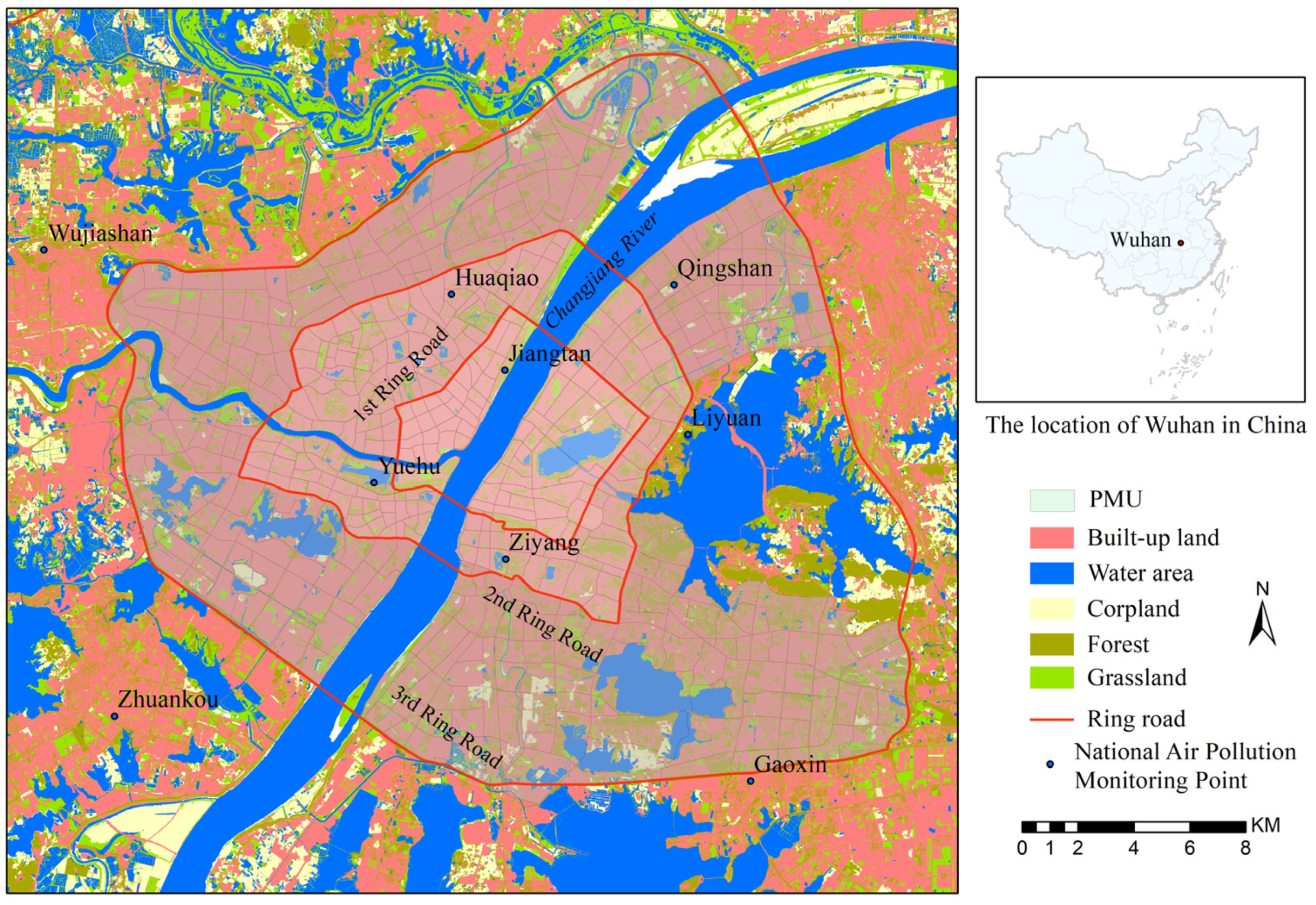
Wuhan is the capital of Hubei Province, China, and the population is about 10 million. With an increasing number of private cars in Wuhan (1 million vehicles in 2010—3.5 million in 2020), vehicle emissions have become a major source of air pollution. The downtown area of Wuhan (about 410 km2 with about 4 million people, about 10,000 persons/km2) was selected as the study area (Figure 1). Most of downtown Wuhan consists of built-up areas of varying densities, and the planning management unit (PMU) was regarded as the unit of analysis. PMU is the unit for regulatory detailed planning (such as zoning) developed by the Wuhan urban planning department. In total, there were 519 PMUs in downtown Wuhan, and the area of PMUs ranged from 0.05 square kilometers (km2) to 6.85 km2, with a mean value of 0.79 km2.
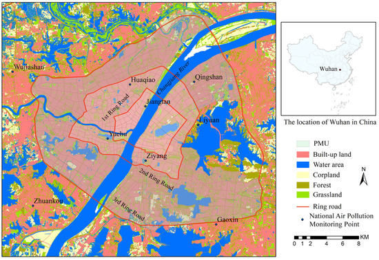
Figure 1.
Study area location.
2.2. Data
Air pollution exposure assessment was conducted for the population in each PMU of downtown Wuhan with hourly population distribution data and hourly air pollutant concentration data. One-hour resolution population distribution maps were derived from smartphone LBS data, and one-hour air pollutant concentration maps were derived from inverse distance weighted (IDW) interpolation with ground monitoring data. Dynamic population density and air pollutant concentration were then matched at the corresponding time and location; this helped to overcome the limitations of estimation based on stationary census data that link exposures solely to residential locations.
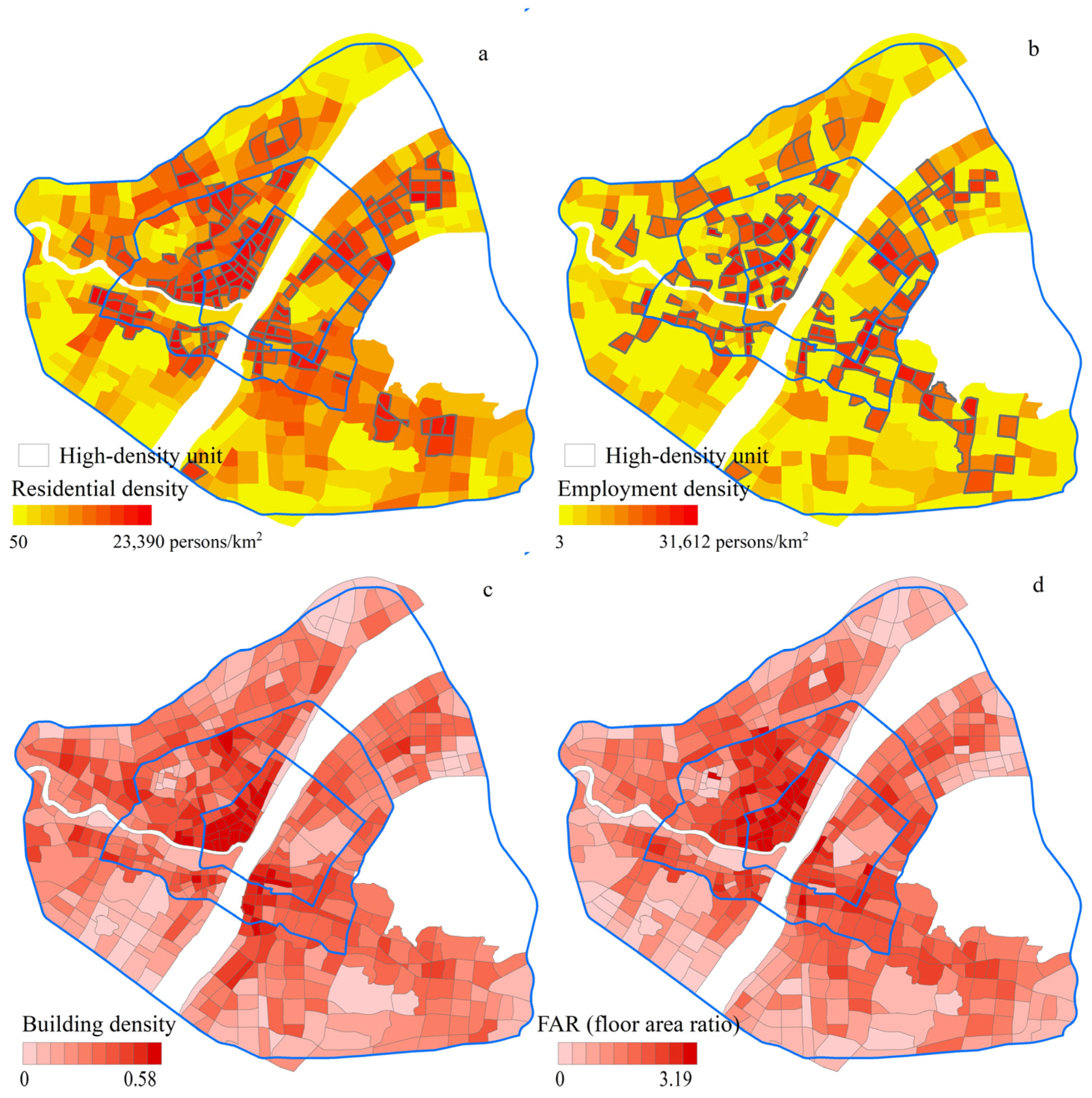
Smartphone LBS data was collected from Jiguang, a big data platform company, and the data included individuals’ locations within Wuhan from Monday, 17 April 2017, to Sunday, 23 April 2017. When a mobile user was using any LBS app (such as QQ or Weixin), the Jiguang database collected the user’s GPS location immediately. In addition, the user’s GPS location is sent to the database periodically when any app using LBS is running. In total, about 2.8 million people were tracked during the week for their position within Wuhan, with a time resolution of one hour, and mapped over the map of PMUs. For each user, the PMU where he or she most frequently used LBS during the nighttime (21:00–7:00) and on weekends was regarded as a residential place, and the PMU where he or she most frequently used LBS during the daytime (10:00–17:00) on weekdays was regarded as an employment place. The total residential population and total employment population in each PMU were summed up, and the residential density and employment density for each PMU were calculated. The study identified PMUs with the top 25% density as high-density residential units and high-density employment units. As shown in Figure 2a,b, most of high-density residential units were located within the first ring road, and high-density employment units were almost entirely located within the first and second ring roads.
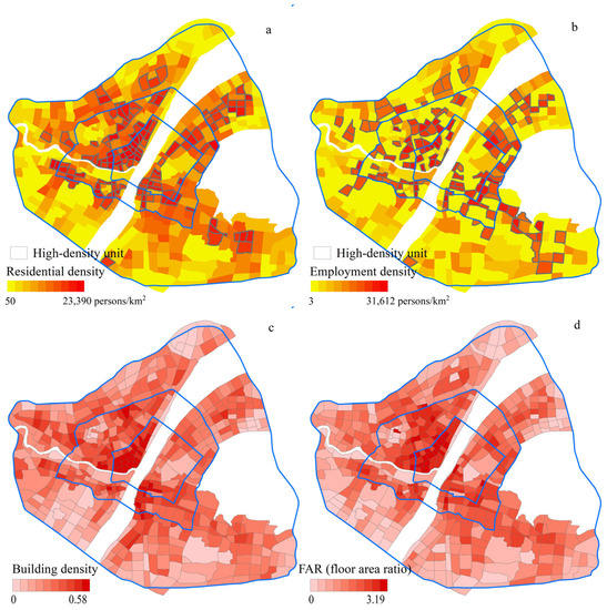
Figure 2.
Population density and urban form metrics.
In order to measure long-term air pollution exposure with different weather conditions, concentrations of PM2.5, PM10, NO2, CO, O3, and SO2 from nine national air pollution monitoring points within or near downtown Wuhan with a resolution of an hour were collected during the whole year of 2017. Annual average concentrations of PM2.5 (53 μg/m3) and PM10 (88 μg/m3) were over the national air quality standard (35 μg/m3 and 50 μg/m3), and the values of other pollutants were below the threshold. Hence, air pollution exposures of PM2.5 and PM10 were measured in this study. We excluded the period with unusual commuting patterns on public holidays (weekends, New Year’s Day, Spring Festival, Tomb Sweeping Day, Labor Day, Dragon Boat Festival, National Day, and Mid-Autumn Festival), and hourly average PM2.5 and PM10 concentrations for each of the nine monitoring points on 250 working days in 2017 were calculated. IDW interpolation was used to calculate hourly concentrations for each PMU with data from nine monitoring points during the period from 6:00 to 21:00.
2.3. Exposure Assessment and Compactness Measures
Hourly average population density data and hourly average pollution concentration data matched in time and space. As shown in Equation (1), we measured air pollution exposure with a population-weighted metric, and it considered hourly population density, hourly air pollution concentration, and air quality standards [9]. The hourly exposure in each PMU was calculated first by multiplying the corresponding population density and air pollution concentration, and then hourly exposures during the study period were added. If the hourly concentration was below the threshold value for the air quality standard, we assumed that its health impact was negligible and the exposure level was zero (Equation (2)). Last, the final air pollution exposure was calculated as the log of the result plus one, both to normalize the variables’ distribution and to eliminate zeros.
where is the air pollution exposure in PMU i, (persons/km2) is the hourly population density of PMU i in the hour t, and (μg/m3) are the adjusted and original air pollution concentrations of PMU i in the hour t, respectively, and s is the threshold value for the air quality standard. Exposures to PM2.5 and PM10 were calculated independently.
GIS data for buildings within downtown Wuhan were collected, and building density and floor-area ratio (FAR) were selected as urban form metrics to measure the compactness of each PMU. FAR is calculated as the ratio between the gross floor area and land area in each PMU. As shown in Figure 2c,d, PMUs within the first and second ring roads were usually much more compact than the others. We used Pearson correlation analysis to evaluate the effect of compactness on population density, pollution concentration, and pollution exposure (population-weighted concentration), and used a spatial autocorrelation analysis tool, Anselin Local Moran’s I for local indicator of spatial association (LISA), to explore the spatial pattern of exposures.
3. Results
3.1. Population Density
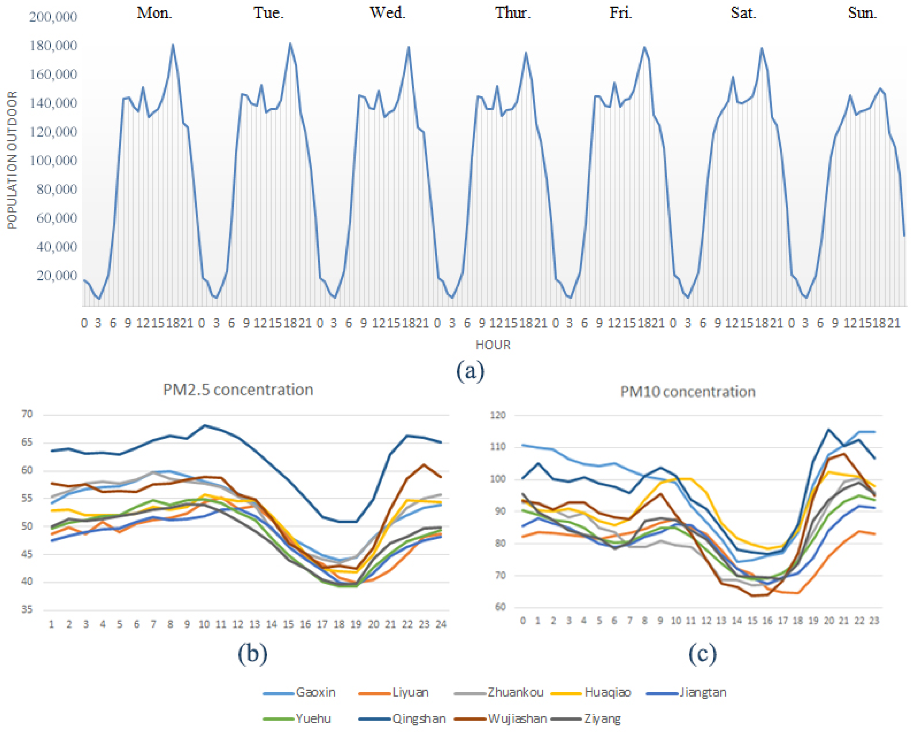
With regard to the air pollution exposure assessment, there is a difference between indoor and outdoor exposure. This study mainly addresses outdoor exposure, and LBS data was used to track people who moved by foot, bike, bus, or car between different PMUs in an hour. In particular, when a user was traveling from or to PMU a in hour t, he or she was assumed to be outdoors and counted to compute the hourly population density of PMU a in hour t. The time series for the total population outdoors in Wuhan derived from LBS data during the sample week is shown in Figure 3a. A periodic traveling pattern was observed on weekdays (Monday to Friday), and the diagram on weekends showed a different curve. People may stay home or travel away from downtown Wuhan on holidays, and the population activity maps on weekends or holidays are not in the scope of this paper. On weekdays, high population density was found at morning rush hour (7:00 to 10:00), noon (12:00 to 13:00), and evening rush hour (17:00 to 20:00). Overnight (21:00–6:00), most people spent their time at home, and the outdoor population density was much lower.
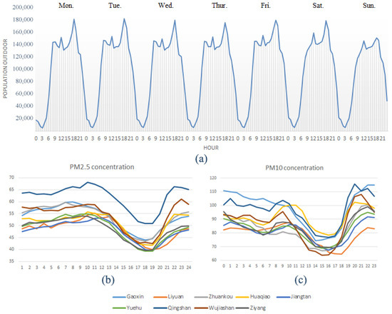
Figure 3.
Time series for hourly population (a) and hourly average PM2.5 and PM10 concentrations (b,c).
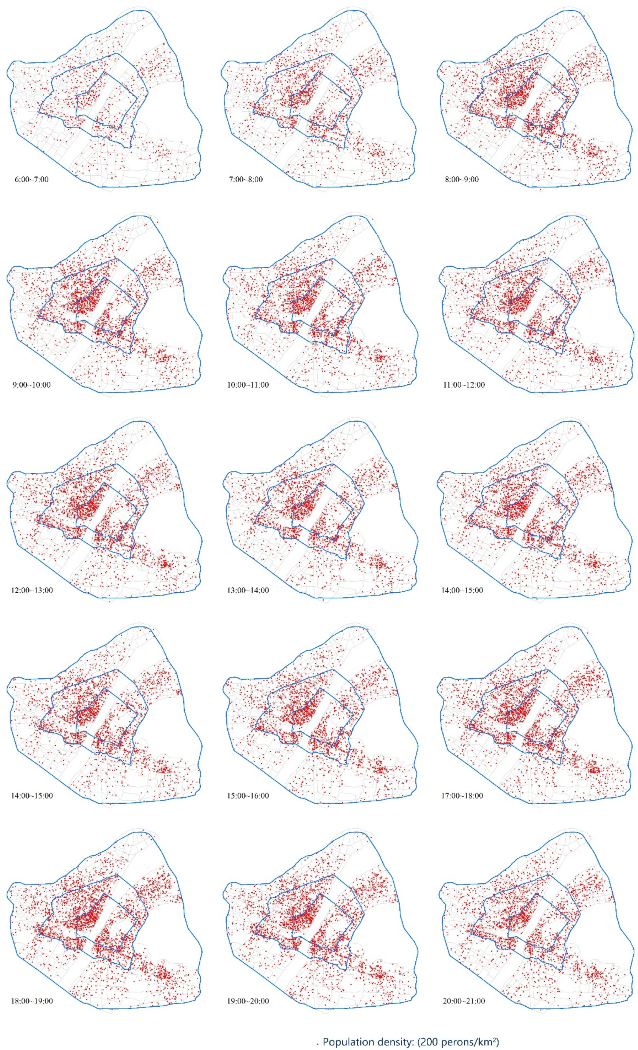
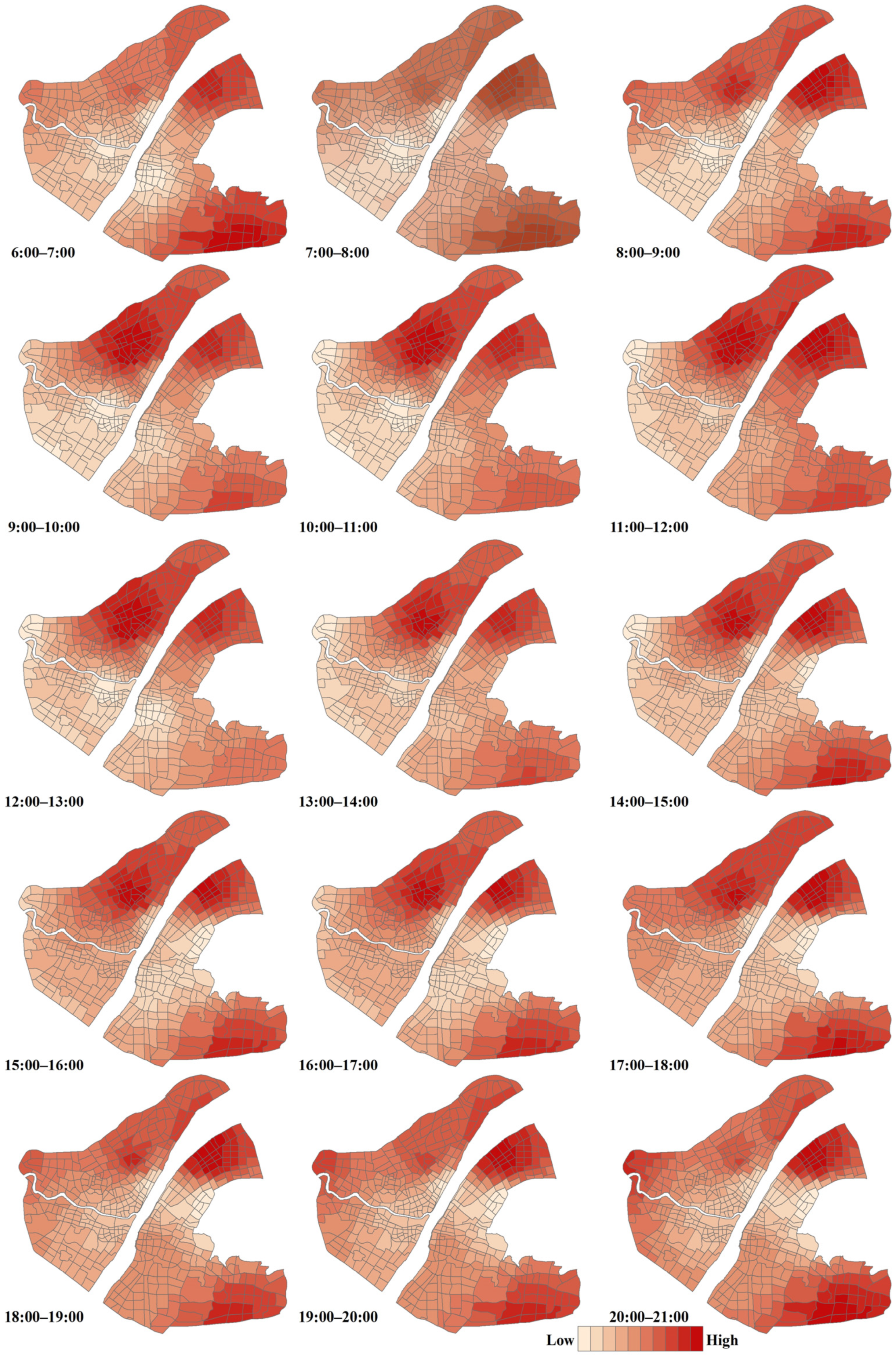
The distribution maps of hourly average population density from 6:00 to 21:00 are shown in Figure 4. Higher population densities were detected in the first ring road than in the third ring road. Building density and FAR showed statistically significant correlations with hourly population density, but r values changed in different areas. For all units in downtown Wuhan, r values were over 0.6 (building density: 0.585–0.637, FAR: 0.739–0.768), and the high-density urban form situated more people outdoors in compact areas.
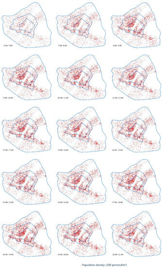
Figure 4.
Hourly population density distribution maps.
3.2. Air Pollution Concentration
Figure 3b,c show the hourly average PM2.5 and PM10 concentrations for each of the nine monitoring points during the working days in 2017. Pollutant concentrations at each monitoring site showed similar trends, and the curves had some relations with the hourly values of population density. PM2.5 concentrations had slow increases from 24:00 to 10:00, declined all the way to the minimum at 19:00, and then increased quickly to 24:00. PM10 concentrations declined gradually from 22:00 to 7:00, raised to a peak during the morning rush hour, dropped to the minimum from 10:00 to 16:00, and surged to a maximum during the evening rush hour. Two peak values of air pollution were probably related to the high population densities during two rush hours, and the increases in pollutant concentrations had a certain delay compared to population changes.
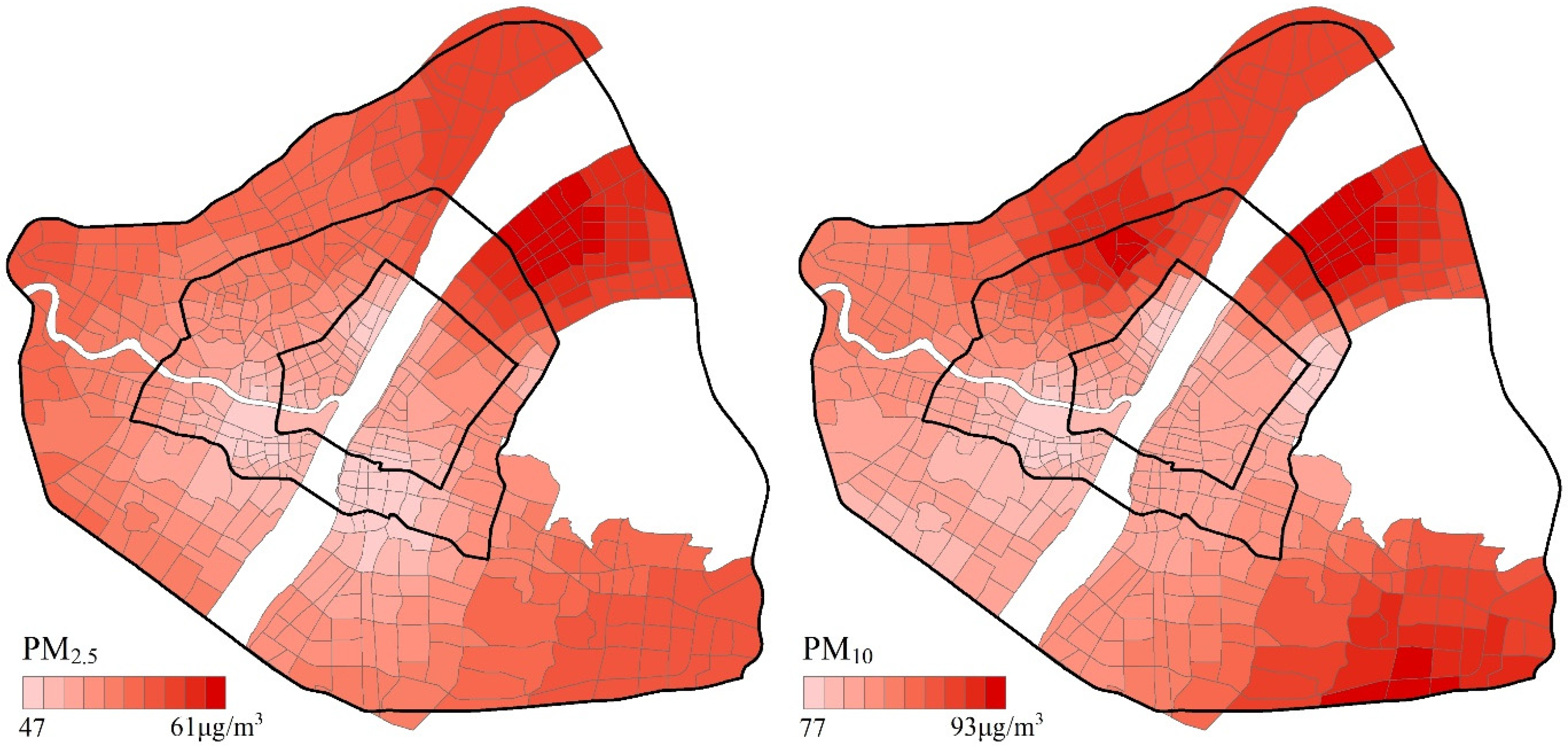
An example of hourly PM10 concentration maps derived from IDW interpolation is shown in Figure 5. Air pollution varied with time and space, and hourly concentrations were lower within the first ring road and higher within the third ring road. Annual mean concentrations for each PMU during the study period were calculated for PM2.5 and PM10 (Figure 6), and Pearson correlation analysis was performed for mean concentrations, building density, and FAR (Table 1). For all units in downtown Wuhan, building density and FAR were negatively associated with PM2.5 and PM10 concentrations. Higher r values of PM2.5 were observed than values of PM10, which suggests that urban actives may contribute a larger portion of PM2.5 pollutant sources compared to PM10. We further analyzed the association in different areas. For high-density residential units and high-density employment units, building density and FAR were negatively correlated with PM2.5 and PM10 concentrations with higher r values. These results suggest that a more compact urban form led to fewer emissions and lower concentrations of PM2.5 and PM10 in downtown Wuhan, and that this effect might be more obvious in high-density urban centers. Correlation analysis was also conducted for the morning peak hour (7:00 to 10:00) and evening peak hour (17:00 to 20:00), and there were higher r values in the rush hours than all day. In the morning, compact urban forms in urban centers may decrease travelling distances and vehicle emissions from commuting people. In the evening rush hour, travelling destinations and distances were diverse, and the effect of urban form on PM2.5 concentration were a little smaller than that in the morning peak.
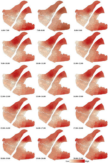
Figure 5.
Hourly PM10 concentration maps.
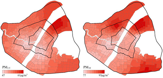
Figure 6.
Maps of mean concentration of air pollutants during the study period.

Table 1.
Correlation between air pollution concentration, building density, and FAR.
3.3. Air Pollution Exposure
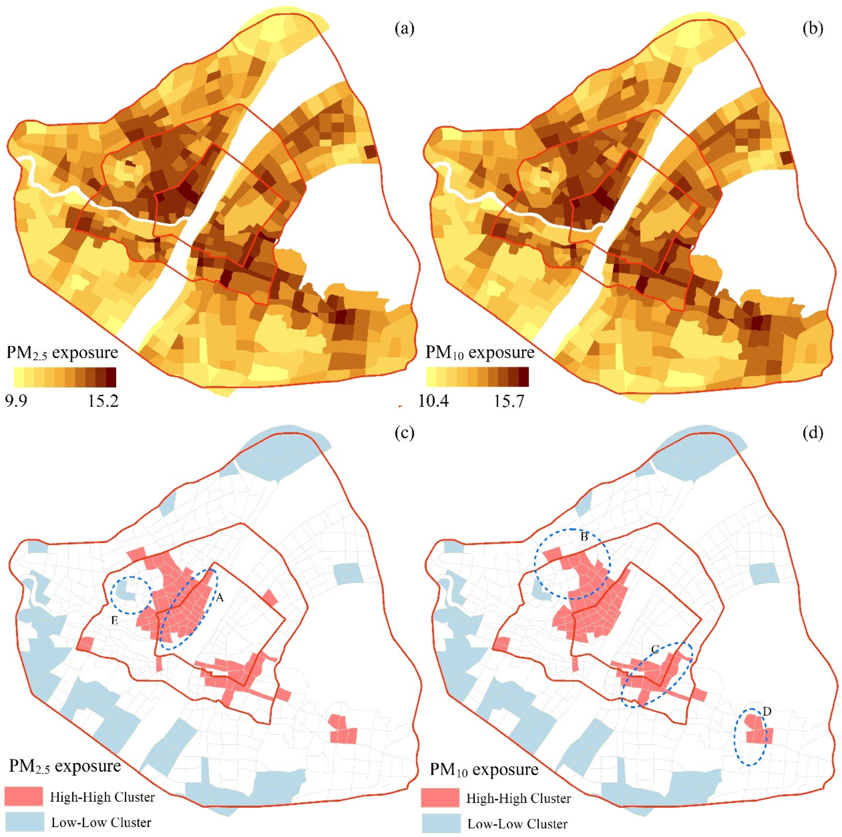
PM2.5 and PM10 exposures on working days of 2017 are shown in Figure 7a,b, and strong variability of exposures was detected as an effect of a time–spatial shift in both population density and pollutant concentrations. Exposures were generally higher within the first ring road area than values in the second ring road area and third ring road area. There was an exception of high exposures in the northeastern area of downtown Wuhan, which may have been caused by industrial pollution from the nearby Wuhan Iron Factory. High-density residential units and high-density employment units suffered from higher PM2.5 and PM10 exposures than other areas. Air pollution exposures at the morning peak, noon, and evening peak were also calculated and compared by paired sample T-tests. For PM2.5, exposures at noon and the evening peak were higher than exposures in the morning peak. For PM10, exposures in the evening peak were higher than exposures at noon and the morning peak.
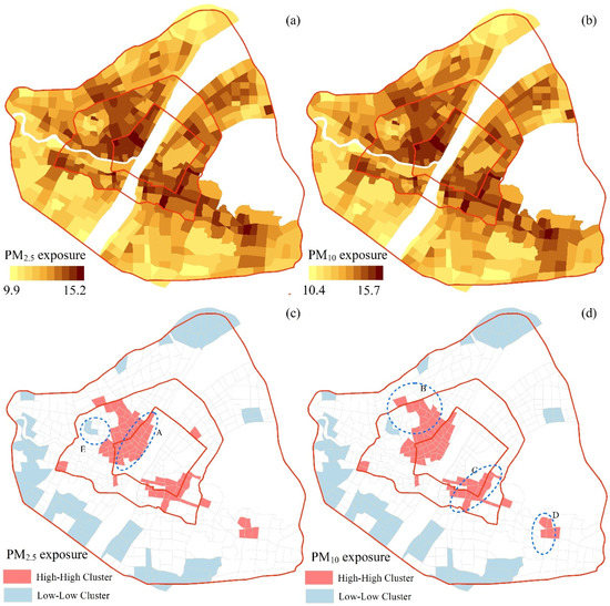
Figure 7.
PM2.5 and PM10 exposure maps.
We used the LISA metric to further study the spatial distributions of PM2.5 and PM10 exposures. As shown in Figure 7c,d, high–high clusters (high exposure units surrounded by high exposure units) were mostly located within the second ring road area, and low–low clusters (low exposure units surrounded by low exposure units) were mainly located on the fringe of the third ring road area. The main finding was that high–high clusters occurred not only in high-density residential or employment areas but also in public centers of downtown Wuhan. For example, Zone A is the Hankou Riverside Zone with integrated commercial, entertainment, and tourism functions, and Zone B is a business and residential zone with commercial, administrative, traffic hub, medical, and other public services. Zone C is an administrative center of Hubei Province with many government agencies located there; it has also become a commercial, business, and recreation center with the development of large malls and office buildings. Zone D has been conceptualized as a sub-center of downtown Wuhan, as proposed by the Wuhan planning department, and it has achieved that goal with integrated functions of high-tech products trade, information services, and other producer services. There is an exception in the low–low cluster of Zone E within the second ring area, because this area (Wangjiadun Central Business District) is still under construction. The above analysis suggests that excessively high population density in urban public centers may increase the level of pollution exposure.
A correlation analysis between urban form and pollution exposures in different areas was conducted (Table 2), and building density and FAR were positively correlated with PM2.5 and PM10 exposures during the peak hour, noon, and all day. Although PM2.5 and PM10 concentrations in compact areas were lower than those in less compact areas, compact development increased the number of people exposed to excessive concentrations.

Table 2.
Correlation between air pollution exposure, building density, and FAR.
4. Discussion
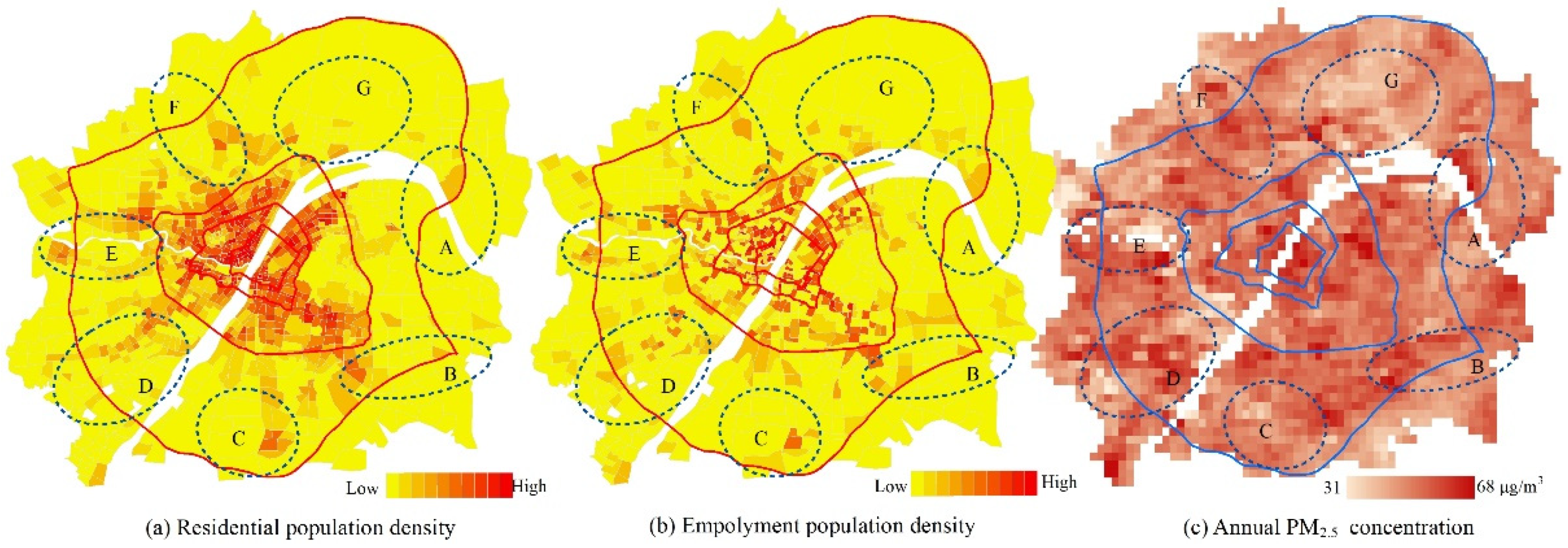
Our study in downtown Wuhan showed that even though air pollution concentration may decrease in compact areas, population-weighted concentrations of PM2.5 and PM10 may increase. The result may be supported by a study on population exposure to air pollution that emphasized the impact of mobile device-based mobility patterns [37]. A micro-scale spatial–temporal study in Guangzhou showed that there were more significant factors of urban forms (e.g., land use and centrality) on PM2.5 concentrations in the evening [38], whereas our study showed that influences of compact urban forms on pollution exposures were quite similar for the morning peak and evening peak in Wuhan. Our findings, based on hourly population density derived from LBS data, were consistent with a previous bottom-up simulation study in China [35]. Compact urban forms may make living places and working places closer, thus reducing trip distances and vehicle emissions. In addition, compact urban forms may make transit more accessible and increase bus sharing rates, for building density and FAR were significantly correlated with the density of bus stations (0.664 **, 0.804 **). A case study in Nanjing showed that compact urban centers with a high density of road networks, a perfect pedestrian system, and complete life service facilities are usually walkable, but are vulnerable to air pollution [39]. People who commute by foot, bicycle, or bus have significantly higher air pollution exposure than those who commute by private car [40]. When concentrations of air pollutants are over the air-quality standard (e.g., PM2.5 and PM10), areas with compact form may suffer from higher levels of population-weighted concentrations, especially for walking and biking. A case study in Shanghai also showed negative effects of compact urban forms with small blocks and dense road networks on respiratory health [41]. Hence, the advantage of shorter trips, walkable streets, and accessible transits in compact areas may be offset by the extremely high density of population and traffic. Both population distribution and pollution concentration matter; hence, it is necessary to reduce pollution exposure through a carefully planned urban structure. For downtown Wuhan, population density was quite high, especially in the second ring road area, and development in surrounding new towns may relieve people in the downtown area. In Figure 8, residential and employment densities derived from the LBS data and annual PM2.5 concentration derived from satellite data [42] in the Wuhan metropolitan area are shown. Zones A through G are planned as new town groups in Wuhan city planning, and compact development in these areas may have different effects on air pollution exposures. For example, moving people away from the downtown area toward Zones B, C, and G would locate people in areas with better air quality. However, compact development in Zones D and F may expose more people to poor air quality.
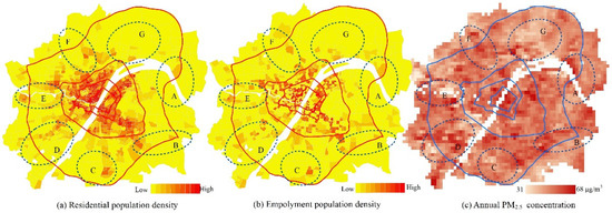
Figure 8.
Employment density and PM2.5 concentration in the Wuhan metropolitan area.
This study has several limitations. First, due to the lack of data availability, we collected the LBS data of one week to reflect population maps of the whole year. Hourly smartphone data of a longer time period should be gathered and applied to evaluate hourly population density and population-weighted concentrations. Second, O3 has gradually become a major pollutant in summer, and the different spatial distribution between O3, PM2.5, and PM10 may yield different conclusions. We primarily considered outdoor population to estimate pollution exposure. Although the time spent indoors was much longer than the time spent outdoors, air pollution exposure based on traffic (especially in the morning and evening rush hours) accounted for a large proportion of the total daily pollution exposure of residents. Last, we did not account for the difference in pollution exposure between different travel modes, which could lead to some biased estimates of pollution exposure. Further studies could use mobility-based real-time assessment.
5. Conclusions
In previous studies, planners often debated whether compact development can improve air quality. However, a consensus has not been reached yet, partly due to lack of information on the relationships among urban form, time–space population distribution, and pollution exposure. We assessed population-weighted concentrations in downtown Wuhan using hourly population data derived from smartphone LBS data and hourly pollution concentration derived from IDW interpolation. The results showed strong spatial variability of PM2.5 and PM10 exposure as an effect of a time–spatial shift in both population density and pollutant concentrations, and high exposures were usually clustered in urban public center areas. Correlation analyses showed that even if compact development helped reduce air pollution concentrations by reducing trip distances and tailpipe emissions, greater compactness increased the number of people exposed to and potentially inhaling air pollutants in excessive concentrations. Therefore, it is necessary to reduce building density and FAR in high-density urban centers and to develop a polycentric urban structure to move people to places with better air quality.
Author Contributions
Conceptualization, M.Y. (Man Yuan); methodology, M.Y. (Man Yuan); formal analysis, M.Y. (Mingrui Yan); data curation, M.Y. (Mingrui Yan); writing—original draft preparation, M.Y. (Man Yuan); supervision, Z.S.; writing—review and editing, Z.S. All authors have read and agreed to the published version of the manuscript.
Funding
This research was funded by the National Natural Science Foundation of China (grant: 51708234, 51708233). Institute of Wuhan Studies Open Project Fund (IWHS20202075).
Institutional Review Board Statement
Not applicable.
Informed Consent Statement
Not applicable.
Data Availability Statement
The data presented in this study are available on request from the corresponding author.
Conflicts of Interest
The authors declare no conflict of interest.
References
- Beelen, R.; Hoek, G.; Brandt, P.A.V.D.; Goldbohm, R.A.; Fischer, P.; Schouten, L.J.; Jerrett, M.; Hughes, E.; Armstrong, B.; Brunekreef, B. Long-Term Effects of Traffic-Related Air Pollution on Mortality in a Dutch Cohort (NLCS-AIR Study). Environ. Heal. Perspect. 2008, 116, 196–202. [Google Scholar] [CrossRef]
- Chen, X.; Shao, S.; Tian, Z.; Xie, Z.; Yin, P. Impacts of air pollution and its spatial spillover effect on public health based on China’s big data sample. J. Clean. Prod. 2017, 142, 915–925. [Google Scholar] [CrossRef]
- Han, X.; Liu, Y.; Gao, H.; Ma, J.; Mao, X.; Wang, Y.; Ma, X. Forecasting PM2.5 induced male lung cancer morbidity in China using satellite retrieved PM2.5 and spatial analysis. Sci. Total. Environ. 2017, 607–608, 1009–1017. [Google Scholar] [CrossRef]
- OECD. The Cost of Air Pollution: Health Impacts of Road Transport; OECD Publishing: Paris, France, 2014. [Google Scholar]
- Ewing, R.; Cervero, R. Travel and the built environment: A meta-analysis. J. Am. Plan. Assoc. 2010, 76, 265–294. [Google Scholar] [CrossRef]
- Cervero, R.; Murakami, J. Effects of Built Environments on Vehicle Miles Traveled: Evidence from 370 US Urbanized Areas. Environ. Plan. A Econ. Space 2010, 42, 400–418. [Google Scholar] [CrossRef]
- Bartholomew, K.; Ewing, R. Land use–transportation scenarios and future vehicle travel and land consumption: A meta-analysis. J. Am. Plan. Assoc. 2008, 75, 13–27. [Google Scholar] [CrossRef]
- Zhao, P.; Lü, B.; de Roo, G. Urban expansion and transportation: The impact of urban form on commuting patterns on the city fringe of Beijing. Environ. Plan. A 2010, 42, 2467. [Google Scholar] [CrossRef]
- Schweitzer, L.; Zhou, J. Neighborhood air quality, respiratory health, and vulnerable populations in compact and sprawled re-gions. J. Am. Plan. Assoc. 2010, 76, 363–371. [Google Scholar] [CrossRef]
- Stone, B. Urban sprawl and air quality in large US cities. J. Environ. Manag. 2008, 86, 688–698. [Google Scholar] [CrossRef] [PubMed]
- Rodríguez, M.C.; Dupont-Courtade, L.; Oueslati, W. Air pollution and urban structure linkages: Evidence from European cities. Renew. Sustain. Energy Rev. 2016, 53, 1–9. [Google Scholar] [CrossRef]
- Yuan, M.; Huang, Y.; Shen, H.; Li, T. Effects of urban form on haze pollution in China: Spatial regression analysis based on PM2.5 remote sensing data. Appl. Geogr. 2018, 98, 215–223. [Google Scholar] [CrossRef]
- Sarrat, C.; Lemonsu, A.; Masson, V.; Guédalia, D. Impact of urban heat island on regional atmospheric pollution. Atmos. Environ. 2006, 40, 1743–1758. [Google Scholar] [CrossRef]
- Taha, H. Meso-urban meteorological and photochemical modeling of heat island mitigation. Atmos. Environ. 2008, 42, 8795–8809. [Google Scholar] [CrossRef]
- Yuan, M.; Song, Y.; Huang, Y.; Hong, S.; Huang, L. Exploring the Association between Urban Form and Air Quality in China. J. Plan. Educ. Res. 2018, 38, 413–426. [Google Scholar] [CrossRef]
- Gariazzo, C.; Pelliccioni, A.; Bolignano, A. A dynamic urban air pollution population exposure assessment study using model and population density data derived by mobile phone traffic. Atmos. Environ. 2016, 131, 289–300. [Google Scholar] [CrossRef]
- Cho, H.-S.; Choi, M.J. Effects of Compact Urban Development on Air Pollution: Empirical Evidence from Korea. Sustainability 2014, 6, 5968–5982. [Google Scholar] [CrossRef]
- Liu, C.; Henderson, B.H.; Wang, D.; Yang, X.; Peng, Z.R. A land use regression application into assessing spatial variation of in-tra-urban fine particulate matter (PM2.5) and nitrogen dioxide (NO2) concentrations in City of Shanghai, China. Sci. Total Environ. 2016, 565, 607–615. [Google Scholar] [CrossRef] [PubMed]
- Zou, B.; Luo, Y.; Wan, N.; Zheng, Z.; Sternberg, T.; Liao, Y. Performance comparison of LUR and OK in PM2.5 concentration mapping: A multidimensional perspective. Sci. Rep. 2015, 5, srep08698. [Google Scholar] [CrossRef] [PubMed]
- Chen, J.; Chen, S.; Landry, P.F. Migration, environmental hazards, and health outcomes in China. Soc. Sci. Med. 2013, 80, 85–95. [Google Scholar] [CrossRef]
- Larkin, A.; Hystad, P. Towards Personal Exposures: How Technology Is Changing Air Pollution and Health Research. Curr. Environ. Heal. Rep. 2017, 4, 463–471. [Google Scholar] [CrossRef]
- Reis, S.; Seto, E.; Northcross, A.; Quinn, N.W.T.; Convertino, M.; Jones, R.L.; Maier, H.R.; Schlink, U.; Steinle, S.; Vieno, M. Inte-grating modelling and smart sensors for environmental and human health. Environ. Model. Softw. 2015, 74, 238–246. [Google Scholar] [CrossRef]
- Su, J.G.; Jerrett, M.; Meng, Y.-Y.; Pickett, M.; Ritz, B. Integrating smart-phone based momentary location tracking with fixed site air quality monitoring for personal exposure assessment. Sci. Total. Environ. 2015, 506–507, 518–526. [Google Scholar] [CrossRef] [PubMed]
- Wu, Y.; Wang, R.; Zhou, Y.; Lin, B.; Fu, L.; He, K.; Hao, J. On-Road Vehicle Emission Control in Beijing: Past, Present, and Future. Environ. Sci. Technol. 2011, 45, 147–153. [Google Scholar] [CrossRef]
- Huang, J.; Lu, X.; Sellers, J.M. A global comparative analysis of urban form: Applying spatial metrics and remote sensing. Landsc. Urban Plan. 2007, 82, 184–197. [Google Scholar] [CrossRef]
- Bento, A.M.; Cropper, M.L.; Mobarak, A.M.; Vinha, K. The Effects of Urban Spatial Structure on Travel Demand in the United States. Rev. Econ. Stat. 2005, 87, 466–478. [Google Scholar] [CrossRef]
- Civerolo, K.; Hogrefe, C.; Lynn, B.; Rosenthal, J.; Ku, J.-Y.; Solecki, W.; Cox, J.; Small, C.; Rosenzweig, C.; Goldberg, R. Estimating the effects of increased urbanization on surface meteorology and ozone concentrations in the New York City metropolitan re-gion. Atmos. Environ. 2007, 41, 1803–1818. [Google Scholar] [CrossRef]
- Hankey, S.; Marshall, J.D. Impacts of urban form on future US passenger-vehicle greenhouse gas emissions. Energy Policy 2010, 38, 4880–4887. [Google Scholar] [CrossRef]
- Martins, H. Urban compaction or dispersion? An air quality modelling study. Atmos. Environ. 2012, 54, 60–72. [Google Scholar] [CrossRef]
- Ewing, R.; Pendall, R.; Chen, D. Measuring sprawl and its transportation impacts. Transp. Res. Rec. J. Transp. Res. Board 2003, 1831, 175–183. [Google Scholar] [CrossRef]
- Bechle, M.J.; Millet, D.B.; Marshall, J.D. Effects of Income and Urban Form on Urban NO2: Global Evidence from Satellites. Environ. Sci. Technol. 2011, 45, 4914–4919. [Google Scholar] [CrossRef] [PubMed]
- Bereitschaft, B.; Debbage, K. Urban form, air pollution, and CO2 emissions in large US metropolitan areas. Prof. Geogr. 2013, 65, 612–635. [Google Scholar] [CrossRef]
- Lu, C.; Liu, Y. Effects of China’s urban form on urban air quality. Urban Stud. 2016, 53, 2607–2623. [Google Scholar] [CrossRef]
- Liu, Y.; Arp, H.P.H.; Song, X.; Song, Y. Research on the relationship between urban form and urban smog in China. Environ. Plan. B Urban Anal. City Sci. 2016, 44, 328–342. [Google Scholar] [CrossRef]
- Yuan, M.; Song, Y.; Hong, S.; Huang, Y. Evaluating the effects of compact growth on air quality in already-high-density cities with an integrated land use-transport-emission model: A case study of Xiamen, China. Habitat Int. 2017, 69, 37–47. [Google Scholar] [CrossRef]
- Calabrese, F.; Colonna, M.; Lovisolo, P.; Parata, D.; Ratti, C. Real-Time Urban Monitoring Using Cell Phones: A Case Study in Rome. IEEE Trans. Intell. Transp. Syst. 2010, 12, 141–151. [Google Scholar] [CrossRef]
- Nyhan, M.; Grauwin, S.; Britter, R.; Misstear, B.; McNabola, A.; Laden, F.; Barrett, S.R.; Ratti, C. ‘Exposure Track’—The Impact of Mobile Device Based Mobility Patterns on Quantifying Population Exposure to Air Pollution. Environ. Sci. Technol. 2016, 50, 9671–9681. [Google Scholar] [CrossRef]
- Zhou, S.; Lin, R. Spatial-temporal heterogeneity of air pollution: The relationship between built environment and on-road PM2.5 at micro scale. Transp. Res. Part D 2019, 76, 305–322. [Google Scholar] [CrossRef]
- Chen, X.; Feng, J. Effects of built environment based on a comparison of walkability and air pollution: A case study of Nanjing city. Prog. Geogr. 2019, 38, 296–304. [Google Scholar]
- Huang, J.; Deng, F.; Wu, S.; Guo, X. Comparisons of personal exposure to PM2.5 and CO by different commuting modes in Beijing, China. Sci. Total. Environ. 2012, 425, 52–59. [Google Scholar] [CrossRef] [PubMed]
- Wang, L.; Jiang, X.; Sun, W.; Zhao, X.; Tang, J. Impact of urban built environment on respiratory health and its planning strategy: A case study of a district in shanghai. City Plan. Rev. 2018, 42, 15–22. (In Chinese) [Google Scholar]
- Li, T.; Shen, H.; Yuan, Q.; Zhang, X.; Zhang, L. Estimating Ground-Level PM2.5 by Fusing Satellite and Station Observations: A Geo-Intelligent Deep Learning Approach. Geophys. Res. Lett. 2017, 44, 11–985. [Google Scholar] [CrossRef]
Publisher’s Note: MDPI stays neutral with regard to jurisdictional claims in published maps and institutional affiliations. |
© 2021 by the authors. Licensee MDPI, Basel, Switzerland. This article is an open access article distributed under the terms and conditions of the Creative Commons Attribution (CC BY) license (https://creativecommons.org/licenses/by/4.0/).

