
Runoff Volume Reduction Using Green Infrastructure


Faculty of Civil Engineering, Architecture and Environmental Engineering, University of Zielona Góra, 65-516 Zielona Góra, Poland
Land 2021, 10(3), 297; https://doi.org/10.3390/land10030297
Submission received: 12 February 2021
/
Revised: 6 March 2021
/
Accepted: 12 March 2021
/
Published: 14 March 2021
(This article belongs to the Special Issue Constructed Green Areas as a Challenge for Spatial Planning at the Local and Regional Levels)
Abstract
:Uncontrolled urbanization is a frequent cause behind the local flooding of catchment areas. This also results in a degradation of water quality in receivers, as well as causing a disruption of the natural water cycle in the catchment. Classical solutions, such as retention, do not prove to be sufficient under all conditions. An alternative solution is the application of low impact development (LID), which, in the analysed case, takes the form of rain gardens, infiltration trenches and controlled unsealing of catchment components. The work presents the influence of a few variants of solutions on a selected urbanized catchment located in Gorzów Wielkopolski. The assessment was developed using a simulation model, making use of EPA’s Storm Water Management Model (SWMM) software. The nalysed design variants are compared with the described existing state before the implementation of modernization works. Previous results showing that LID may be ineffective as the only solution in systems overloaded with runoff generated by rainfall of relatively low intensities were confirmed. In the case of existing systems, LID should be applied in combination with classical retention systems or in a treatment train and every opportunity to implement LID whether on a property or urban site must be taken. Such solutions in the analysed cases will allow for a reduction of the maximum outflow intensity from the analysed subcatchment by 9 to 17% depending on the analysed rainfall. The results are similar to those obtained in other implementations. However, the interpretation of the results is not as simple and obvious for overloaded systems. In addition to flow rate reduction, reduction of surcharge in the sewer network and reduction of the volume of local flooding must be considered. LID solutions should also, whenever possible, be looked into as early as the stage of planning the land development of the infrastructure.
1. Introduction
The increasing share of impervious surfaces in urban areas has led to significant changes in the properties of catchment characteristics, e.g., in Warsaw, the share of sealed impervious surfaces, in relation to the entire surface area of a given catchment in the centre of the city, amounts to approx. 0.9, whereas on the outskirts of the city, this value falls between 0.4 and 0.7 [1]. The extent of native vegetation is limited, along with a reduction in the area occupied by natural shallow depressions of the soil that make the interception, collection and infiltration of rainwater possible. This leads to an increase in the speed and volume of runoff, at the same time limiting evapotranspiration and interception [2]. The observed changes carry over onto the increase in extreme flows, decreasing the time of concentration, generating changes in the water balance and causing sudden increases of flows in rivers and other water courses in the area of the urban catchment [3]. Implementations of new solutions for managing rainwater are a consequence of increasingly severe climate changes [4] and are often forced by changes in legal regulations in terms of environmental management. In many large cities throughout the world, LID methods are used to plan, develop and optimize stormwater management [5]. The term Low Impact Development (LID) has been used in North America and New Zealand since 1977 [6]. The basis for the technique is minimizing the costs of managing rainwater by “design with nature approach” connected with infiltrating the first flush of stormwater runoff. In contrast to classical rainwater management relying on the transport to central retention structures, LID is characterized by dispersed smaller devices for managing rainwater, such as bioretention systems, green roofs and filtration ditches, found near the sources of runoff or in its proximity [7]. Currently, low impact development (LID) indicates hydrological aims as key to both modernized existing as well as new urban catchments. One of the most important rules of LID is the introduction of new concepts, technologies and aims of wastewater management, such as micromanagement and multi-functional landscape features: hydrological functions ought to be imitated or reproduced [8]. Other countries apply a similar approach. In Great Britain, under the term of sustainable urban drainage systems (SuDS), in Australia—water sensitive urban design (WSUD), in France—Integrated Urban Water Management (IUWM) and alternative techniques and others [6]. The benefits stemming from the use of SuDS (LID) to local societies are manifold, including [9], especially reducing the risk of urban flooding and partially restoring the water cycle in the catchment area. Sometimes the term green infrastructure (GI) is being used in the stormwater literature in a way that is almost synonymous with LID [6]. The central idea of green infrastructure is, of course, to use plant systems to provide the desired ecosystem services. In densely built-up city centres, where the location of retention facilities and green infrastructure is difficult or even impossible, a gradual replacement of the surface should be considered. Above all, surfaces made of materials with an increased hydraulic conductivity such as pervious concrete should be designed [10]. Changes that are relatively easy to implement include surface of parking places along roadways (Figure 1), complete parking lots located near multi-family buildings (Figure 2) and garage driveways of single-family, semi-detached and terraced houses. Depending on traffic density and local conditions, the following are used: concrete grid pavers systems [11]—comprised of concrete blocks with voids inside the blocks which also create voids between blocks or plastic grids that add structural support to the topsoil and reduce compaction to maintain permeability (Figure 1 and Figure 2).
The scope and possibility of attaining the mentioned advantages depends on many factors, including properties dependent on location and environmental factors. High effectiveness of LID is observed in the case of phenomena with a high frequency of occurrence in the analysed period. In the case of spread-out catchments, LID techniques work best in connection with traditional solutions of managing stormwater, such as classical retention tanks [5] or as an element of a comprehensive solution, such as “sponge city” [12,13]. Damodaram et al., [14] confirmed that the conventional approach to assessing the strategy of managing rainwater uses typical sets of classical models of rain series (e.g., two-year rainfalls). The obtained results indicate that the range of applied rainfall models ought to be expanded to include rainfalls of low intensity, which will make it possible to adequately assess the influence of both classical solutions as well as LID technologies. A range covering rainfalls with a frequency of occurrence from six months to two years was indicated as optimal [15]. The highest effectiveness of implementing LID technologies was obtained in the case of buildings or residential areas fundamentally designed as ecological, directed at the sustainable management of media [16]. In the case of implementing LID technologies in already existing residential development, such optimistic results are not observed in every case. Very good results are possible to obtain in the case of systems which cover large areas of rooftops, such as in shopping centres or multi-story parking structures [17], or various types of public service buildings [18].
Based on the studies carried out to date, it is possible to pose a thesis that it is feasible to achieve beneficial effects connected with the application of LID, such as decreasing runoff or delaying peak flow intensity. In certain cases, however, LID cannot be treated as the sole method of returning the state of the catchment to the conditions that were present prior to urbanization.
The implementation of LID techniques is connected with various types of limitations. The following are indicated as the basic groups of factors considered to be barriers limiting the scope of these techniques [19] related to institutional problems, such as the lack of design standards and guidelines and the tendency to maintain the status quo and aversion to novelty.
Liu, Bralts and Engel [20] presented an analysis based on 15 scenarios of implementation in various combinations of 12 LID and BMP (Best Management Practices) solutions. The analysis carried out made it possible to indicate that the collection of rainwater (directly on the land plots assigned to a given property) is connected with the lowest costs and displays the highest economic efficiency (cost calculated per 1 m3 decrease of runoff into the sewer system). The annual costs of the optimal solution are also confirmed by the analyses of catchments located in densely built-up urban areas [21]. In this case, included among the best solutions was the collection of rainwater in barrels. Another solution requiring relatively low financial outlays and, at the same time, fitting well into an urban landscape with low-density housing may be the introduction of rain gardens. The use of rain harvesting involves a certain risk associated with the operation of the system. There is a potential possibility that the user, after filling the barrel, will not take any use of the accumulated water and as a result, the tank will be completely filled the next time it rains. The rain garden has no such disadvantage and the user’s influence on operating conditions is limited.
Depending on local possibilities, it is possible to apply one of two solutions:
- locating rain gardens within the borders of a given property—large amount of dispersed LID solutions;
- centralized location in public areas [22].
There are also alternatives that include the integration of several BMP or LID solutions in combination with the treatment’s components. The stormwater treatment trains are designed to maximize the performance and robustness of the entire system [23].
In the first case, small rain gardens serve to limit the runoff of rainwater into the sewer system, under the assumption of the partial introduction of water into the soil in the area where runoff originates. In the second case, rain gardens take on the function of a drainage system supplied by overflow.
In typical solutions to rain gardens, the planting of vegetation can take place at any moment during the vegetation season as long as they are watered. If irrigation is difficult, planting in autumn may be recommended [24]. A vast variety of plants can be anticipated in rain gardens, though plant species that do not tolerate periodical flooding well ought to be avoided. Moreover, plants pone to the rotting of roots should also be avoided.
How often a rain garden gets flooded will depend on the size of the rain garden and the weather; thus, it is important for the garden to be constantly monitored. Examples of plants whose use is encouraged in the area of the UK have been presented in Table 1.
In other countries, the possibility of realizing such gardens in the form of vegetable rain gardens is indicated. Examples of vegetables and herbs applied in Australia include [25]: Onion (Allium cepa), Leek (Allium porrum), Beetroot (Beta vulgaris), Capsicum/Chilli (Capsicum annuum), Cucumber (Cucumis sativus), Lettuce (Lactuca sativa), Basil (Ocimum basilicum), Parsley (Petroselinum crispum), Common bean (Phaseolus vulgaris), Tomato (Solanum lycopersicum), Spinach (Spinacia oleracea) and Broad bean (Vicia faba).
An Australian compilation based on vegetables and herbs is unlikely to find followers in central Europe. In the case of the English guidelines, a comparison with local guides published in Poland, some plants are common. Identical ones can be listed: Yellow flag (Iris pseudocorus), Male fern (Dryopteris felix-mas), Royal fern (Osmunda regalis) and Siberian flag (Iris sibirica) [26].
The application of LID, including rain gardens, rainwater harvesting or combined solutions in a dispersed version, on the scale of individual households, is a recommended and effective solution for returning the natural water cycle to the environment. It should not be treated as a sole remedy for the protection of cities against local flash floods. In the case of newly designed systems and under the assumption that the planned solutions will be implemented on all properties, the efficiency of the system may, in particular cases, prove to be sufficient. In the case of existing systems, which are potentially already currently overburdened [27], the situation is not so simple, with feasible and reliable solutions in such cases being possible to obtain by means of analysis with the use of computer modelling. As a result of the works carried out so far, it has been indicated that, in the majority of cases, it is necessary to simultaneously apply classical solutions, such as delaying retention or runoff in a network of conduits incorporating LID techniques.
Currently, many hydrological models with various possibilities and levels of complexity are being applied, including: SCS (Soil Conservation Service), SWAT (Soil-Water Assessment Tool), MOUSE (Model Urban Sewers, Danish Hydraulic Institute, 1995); Hydro CAD and Storm Water Management Model (SWMM) [28]. Sensitivity analysis carried out by Bosley [29] for 19 of the most frequently used hydrological models or computer systems for an identical area of comparison revealed the SWMM to be one of the most efficient hydrological models for application in urban areas. This is true of both, classical solutions as well as the implementation of LID techniques. Among the main advantages of SWMM is the possibility to obtain proper results of simulations with a low workload based on short-term measurement campaigns [2,29,30]. SWMM is characterized by possibilities similar to commercial programming and contains hydrological, hydraulic and quality modules. This also allows for the simulation of elements of automatics and control. Inconveniences, such as the lack of possibility to transfer data from CAD and GIS environments can be eliminated by creating simple applications which require only moderate programming skills in high-level languages. The possibilities of SWMM enable the analysis of the stormwater sewer system as well as the combined sewer system [31]. Although the possibilities of SWMM in the scope of classical solutions are impressive, they appear to be rather limited in the case of parameters representing the implementation of LID. For example, the module for calculating swales covers only the depth of the retention layer, the volume concentration of plants, the roughness of the surface, the slope of the surface and the swale side slope, but does not cover the location of the overflows, the condition of the vegetation and others [32]. Due to the limited implementation of LID techniques in the SWMM model, in some cases the necessity of applying complementary algorithms allowing for the optimization of solutions and, above all, accelerating simulation calculations are indicated [33]. Dedicated models allow for a much more accurate estimation of the effectiveness of the LID [34] and the assessment of boundary conditions (soil moisture content) [35]. However, lack of integration with the hydraulic model currently limits their use. The open code of the SWMM program gives the possibility to include such models in the future. The SWMM model, as the examples show, allows for the analysis of issues that were probably not initially planned by the software authors [36]. However, such issues should be approached with great caution, as some limitations of the model may result in significant, unpredictable errors [37].
As a result, it was determined that the optimal solution for constructing a simulation model is applying the Storm Water Management Model EPA (SWMM) software. The history of the program begins in 1971 and, since that time, the application has gone through many, frequently revolutionary modifications and improvements. The SWMM was developed with the intention to be used, above all, in urban areas. This makes it possible to realize both, a short-and long-term simulation accounting for the quantity and quality of water [38], whereas the ability to locate LID techniques in the analysed system has existed since July 2010 [32]. Storm catchments in SWMM are treated as non-linear tanks, supplied with water from rainfalls and neighbouring catchments, generating runoff after accounting for losses, such as surface runoff, infiltration and evaporation. The surface retention, represented by flooding, wetting of the surface and depression storage on an area of the surface, describes the dead volume of these reservoirs [39].
Storm water management is usually a very broadly considered concept. The fundamental differences between large-scale retention tanks and solutions directly related to LID are important. In the first case, the usual effect of implementation is to improve the safety of the catchment, i.e., to reduce the scale of local flooding and flattening of the outflow wave flowing into the receiver. The goal to be pursued is to reduce the negative impact of urbanization on the hydrological conditions of land. Simple in implementation and easily accepted by the inhabitants, local tanks are currently a very popular solution in Poland. This is confirmed by the results of competitions for funding for this type of investment at the national level and local governments. However, in conversations with representatives of companies managing stormwater drainage systems, great concerns arise in relation to the proper operation of these facilities. This type of rain catchment is not maintenance-free and the user must ensure an appropriate regime of using the accumulated rainwater—possibly fast emptying the tank, cleaning the filters, etc. In addition, practically all projects indicate the use of water for watering vegetation, so it would be easier to avoid the collection in the tank in favour of introducing the water directly into the ground wherever it is possible. As a result, it is necessary to synchronously implement objects that enable rainwater infiltration as close as possible to the place where precipitation occurs.
LID techniques are an important step towards restoring the natural water circulation in the subcatchment in urbanised areas. In the case of existing systems equipped with an overloaded sewage system, however, it is not a means of protection against floods in urban areas without the synchronous implementation of classic retention tanks. A simulation model prepared using the SWMM software was used to estimate the optimum size of a domestic rain garden with an efficiency similar to that of the previously analysed rain barrel. The boundary condition is, on the one hand, the size of the parcel and, on the other hand, the acceptability of the solution by the owner of the property, as well as the terrain possibilities in municipal areas.
2. Materials and Methods
In the described studies, the dynamic wave theory was applied as a model for calculating hydrological runoff and flows, while infiltration from pervious terrain was estimated using the Horton method [38].
The choice of location for carrying out the analysis in the form of a solely rainwater catchment was influenced by the following issues:
- local urban floods and flooding occur even in the case of low intensity rainfalls;
- due to the soil conditions, LID based on infiltration cannot be applied in the entire area of the catchment;
- the existing form of development and management of the area allow for the implementation of simple rainwater collection systems [12];
- the location of LID structures is possible mainly in the area of private land plots.
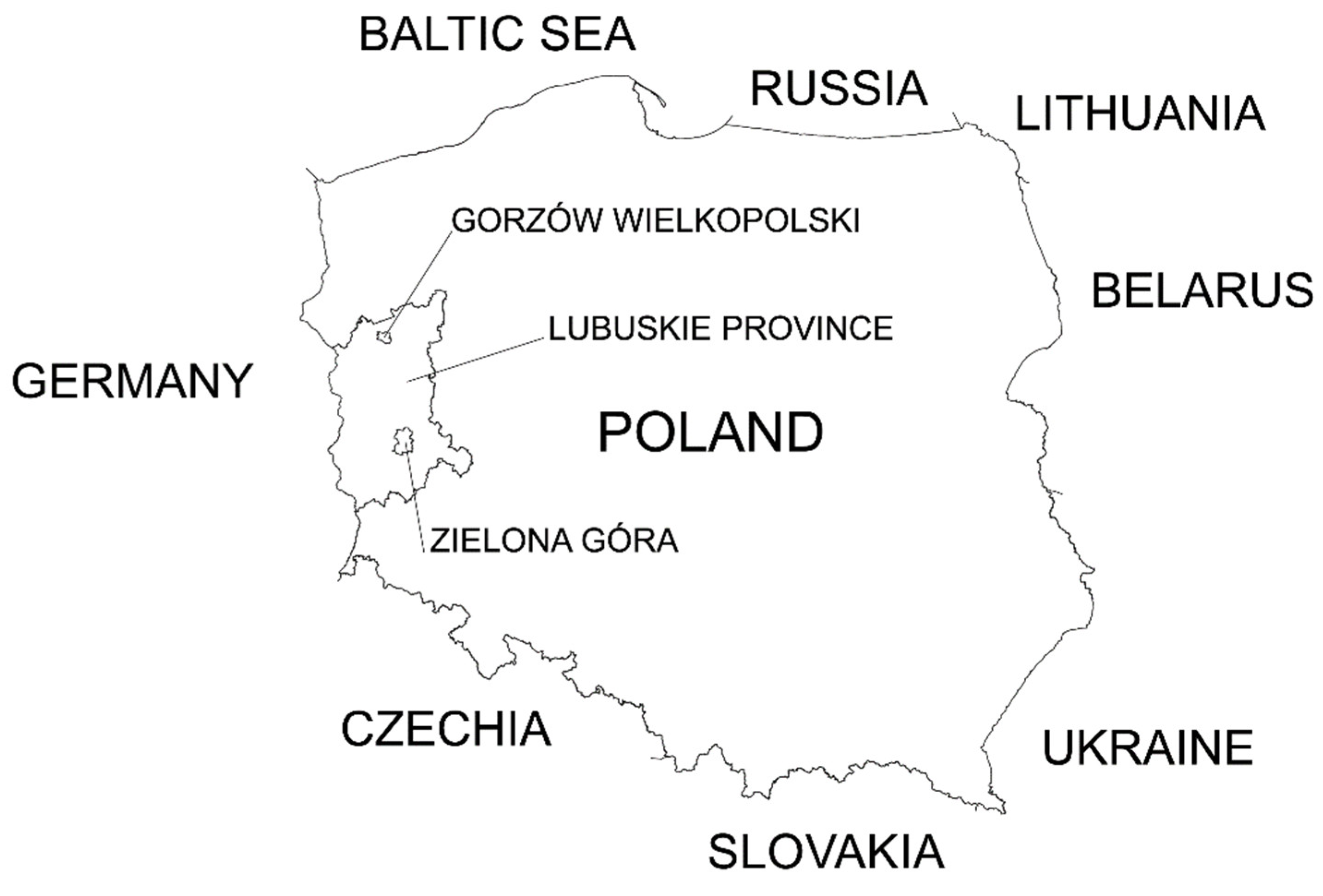
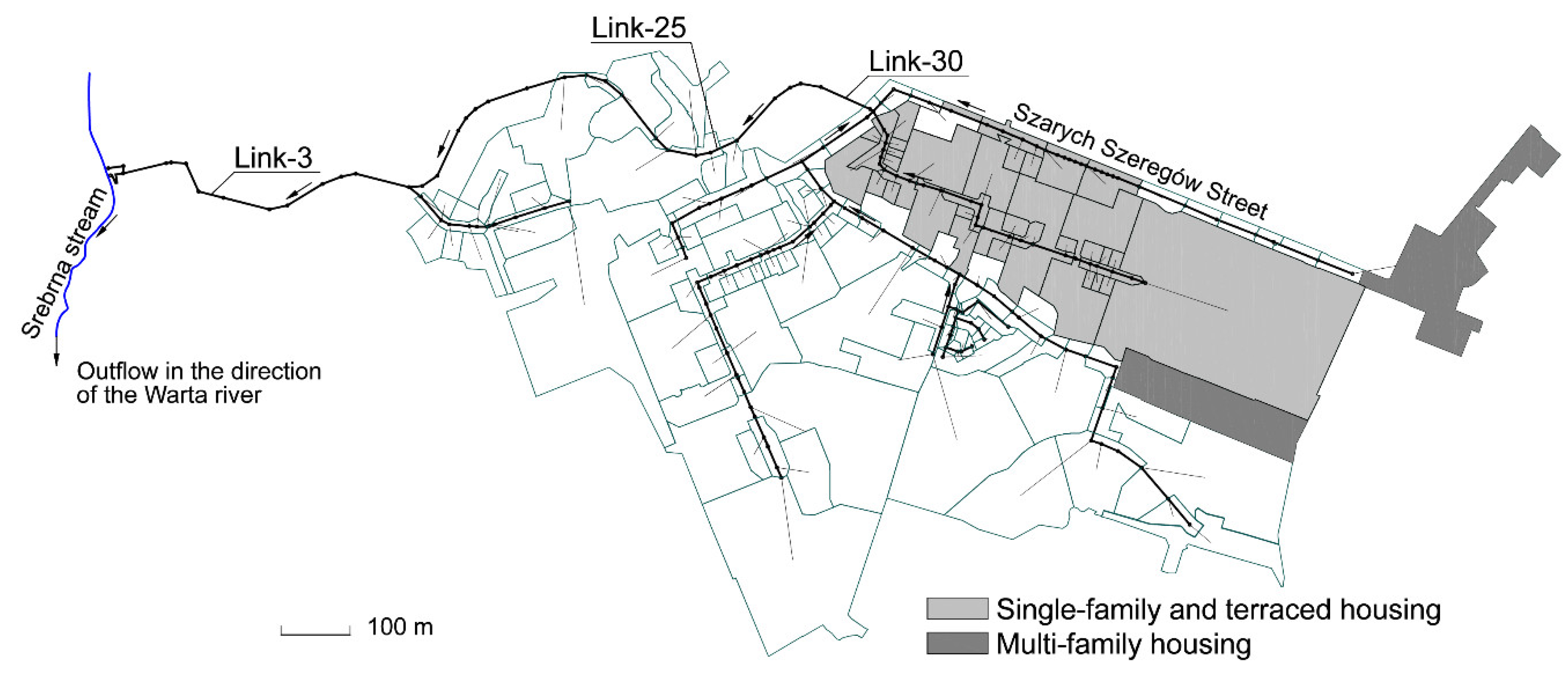
The analysed catchment area is located in Gorzow Wielkopolski, one of the two capitals of Lubuskie Province in Poland (Figure 3). The catchment is one of several dozen catchments—each one has practically independent drainage system. The object is located in the northern part of the city. The receiver of stormwater is the Srebrna stream (Figure 4), a tributary of the Kłodawka river, which flows into the Warta river, Poland’s second-longest river within its borders after the Vistula and third-longest in total length. The calculation sample was carried out using a calibrated simulation model of a chosen subsystem of draining rainwater connected with a separated rainwater catchment [40]. The model was prepared in 2016 and calibrated by a commercial company using measurement data obtained during a measurement campaign carried out in 2016 and 2017. The user of the stormwater drainage system—Gorzów Wielkopolski City Council—makes use of the model to plan its modernization and development, as well as carrying out an analysis of reducing inflows. Currently, the task accounting for the construction of retention tanks, modernization of existing retention-infiltration tanks and reconstruction of the network of canals is being executed. The model describes unitary stormwater catchments with a combined area equal to 68.5 ha (Figure 4). The analysis of the permeability of the catchments allowed the impervious surface of the catchment to be estimated at 35 ha.
The developed model consists of:
- Calculation nodes—190 nodes and 2 outlets;
- Calculation segments—189 segments of canals;
- Stormwater catchments—140 catchments;
- Series of data—such as rainfall data, modelled and historical—registered at the IMGW meteorological station.
The following calculation variants were analysed:
- V1—current state—as a variant of the lack of assumed modernization decisions—described by the calibrated simulation model;
- V2—modernization based on classical methods—mainly retention;
- V3—retention and infiltration in rain gardens;
- V4—retention and infiltration in rain gardens and infiltration trench;
- V5—retention and infiltration in rain gardens and infiltration trench connected with unsealing garage driveways and parking places near multi-family buildings.
where RG = Rain Garden; RB = Rain Barrel.
Variants accounting for storage cover the following implementations, which are present at the stage of realization [40]:
- reinforced concrete, underground retention chamber with an active capacity of 320 m3;
- an underground reinforced concrete tank with an active capacity of 460 m3, including a tank with a capacity of 100 m3 for pre-treated sewage with an uptake point for water for municipal purposes;
- modernization of existing open retention tank, with an active capacity of 3640 m3, including 100 m3 of the tank for pre-treated sewage with an uptake point for water for municipal purposes;
- constructing a by-pass eliminating the influence of too densely located wells in Szarych Szeregów Street;
- reconstruction of conduits situated with a negative slope.
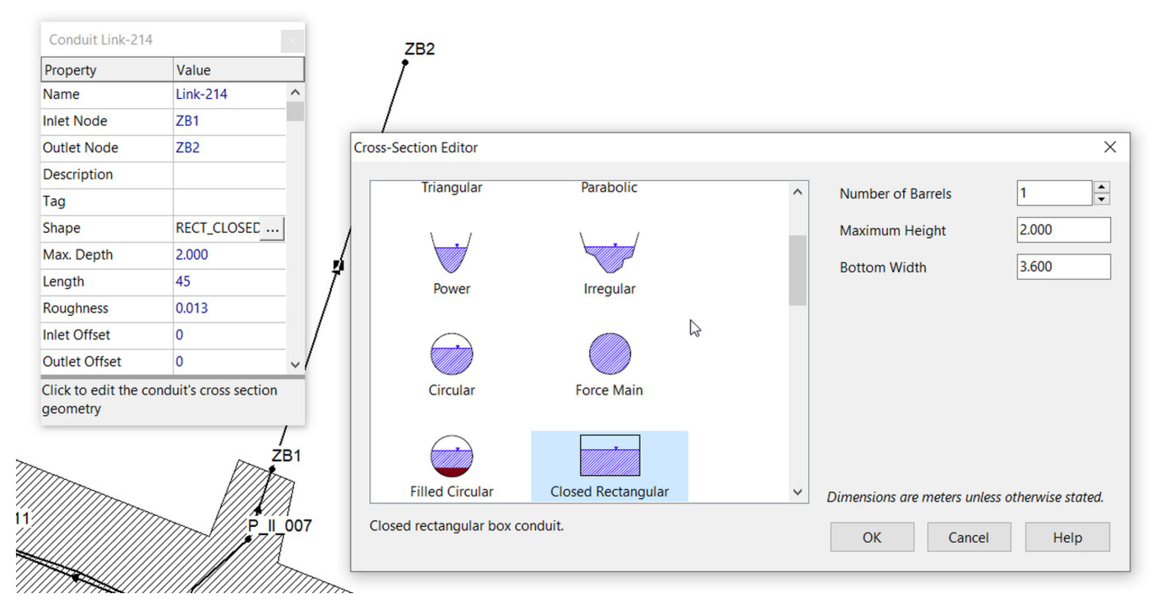
The retention tanks in the model are represented by closed conduits with a rectangular cross-section (Figure 5). Storage unit nodes implemented in EPA SWMM allow only open storage tanks to be simulated.
The proposed solutions are characterized by a classical approach to managing rainwater. Earlier analyses indicate that the described catchments have a significantly higher potential, which may be used when applying even simple LID techniques.
The analysis was carried out using Euler type II model rainfalls with a frequency of occurrence F = 2 years (Figure 6), F = 3 years (Figure 7) and F = 5 years (Figure 8). A rainfall with a duration that was twice longer from the maximum flow time in the network was assumed. At a flow time of close to 20 min, a rainfall duration equal to 45 min. was assumed. In order to prepare the simulation, a Bogdanowicz-Stachy model was used, developed based on 31 maximum rainfalls, with the greatest one selected from each year under observation (1960–1990) for 20 meteorological stations. The application of the model is limited to the F > 1 year [41]:
where:
- hmax—maximum rainfall depth, mm;
- t—duration of rainfalls, min.;
- p—probability of exceeding rainfalls: p ∈ (0,0.5];
- α—parameter dependent on the region of Poland and duration time t.
A rainfall garden was anticipated on each property, regardless of the type of development. The surface area of each rain garden was assumed as equal to 12 m2.
Input data for each object:
- Berm Height—100 mm;
- Vegetation Volume Fraction—0.1;
- Surface Rougness—0.013;
- Surface Slope—1%;
- Soil Thickness—1000 mm;
- Porosity (volume fraction)—0.33;
- Field Capacity (volume fraction)—0.25;
- Wilting Point (volume fraction)—0.15;
- Conductivity—100 mm/h;
- Conductivity Slope—1;
- Suction Head—5 mm.
The runoff is captured only from the roof, with excess water directed to the currently existing storm lateral. Water from driveways will additionally be directed to the stormwater drainage system in the street. The realization of variants covering water collection from rooftops of buildings comprises the location of 234 rainfall gardens in areas built-up with single-family, semi-detached or terraced houses. The total surface area of the catchment subjected to modernization is 14.5 ha—21% of the surface area of the entire catchment. The impervious catchment included under the modernization was estimated to be 7 ha—20% of the impervious surface area of the entire catchment.
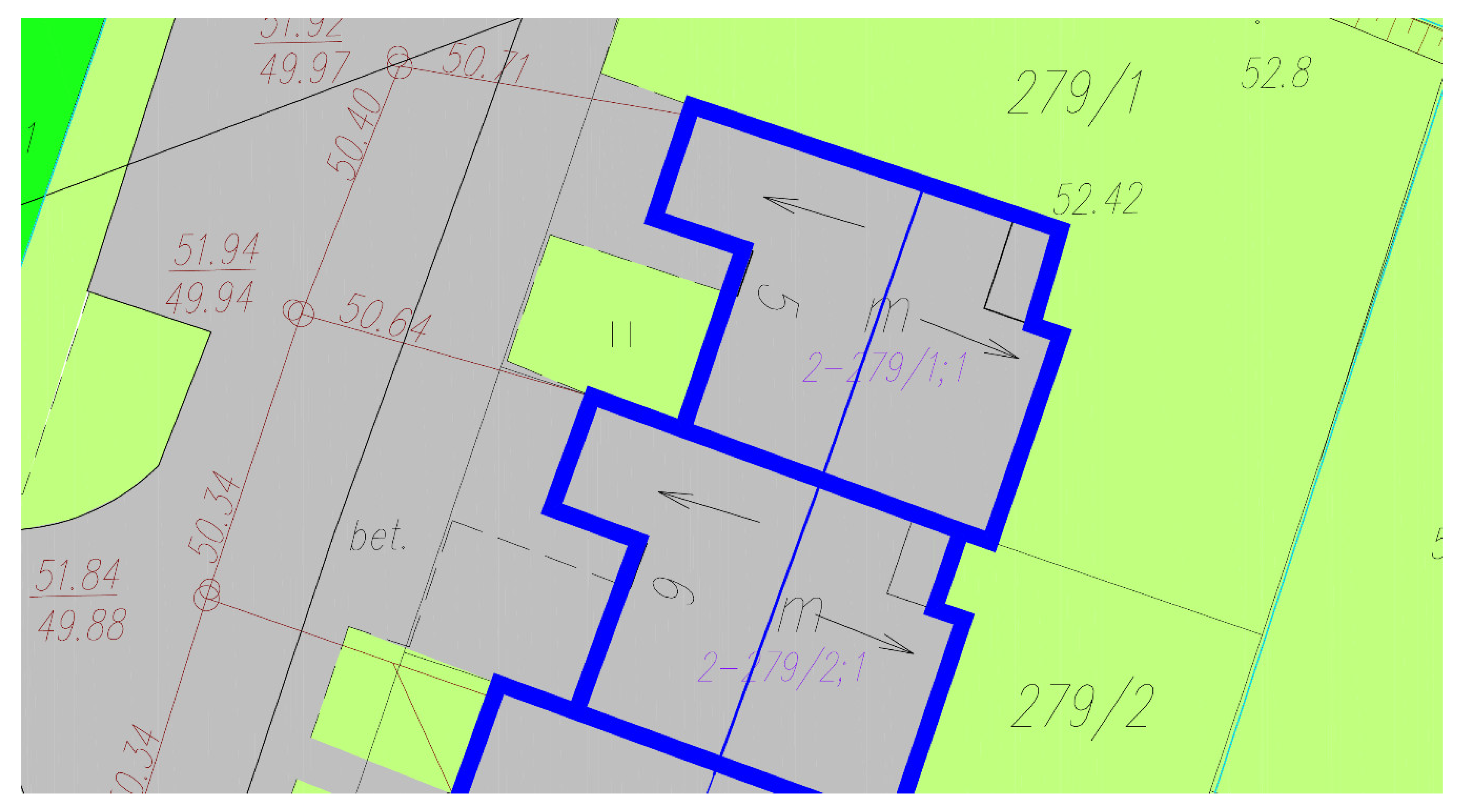
Due to the fact that most of the buildings are covered with a gable roof, for some of the buildings, mainly terraced (Figure 9), it will not be possible to easily adapt using a single LID. Figure 9 shows the range of roof slopes with bold blue line and ridge board with thin blue line (arrows indicate the direction of runoff). The optimal location for a rain garden is in the area at the rear of the buildings. In the case of a gable roof and already implemented pipelines planned as an outlet to the municipal network, this solution may not be technically possible. In addition, on the front side of the buildings, there is usually not enough space reserve to accommodate a rain garden of the planned size. Therefore, variant V4 introduces for half of the roof a rain garden with a reduced area of 6 m2 (located, e.g., on the garden side) and an infiltration trench as an element supporting the part of the building on the entrance side. Infiltration ditches with the width of 1.3 m were planned so that the area did not exceed 4 m2.
Variant V5 utilizes essentially all of the remaining implementation options on both the property owner and municipal side. The following have been planned:
- infiltration trenches along the street on the northern border of the analysed subcatchment;
- unsealing garage driveways in single-family, semi-detached and terraced houses;
A complex issue is the methodology of assessing the effectiveness of the applied solutions. Usually, flow rate reduction in the selected cross-section is indicated as the primary criteria. However, this may not be a valid solution in the case of an overloaded system. Mutual surcharging of individual branches reduces the flow rate and causes a disproportionate increase of depth. As a result, in addition to the change in flow rate, the change in depth, the volume of flooding and the total volume of stormwater discharged were included in the analysis.
3. Results
As a result of the simulation of all of the mentioned calculation variants, results were obtained under the following assumptions:
- the calculations were carried out for a full day;
- a simulation of a preliminary day was introduced with the assumption of rain-free weather, due to the entirely separate nature of the stormwater network;
- the calculations were carried out under the assumption of a calculation step equal to 1 second and reporting every 15 seconds.
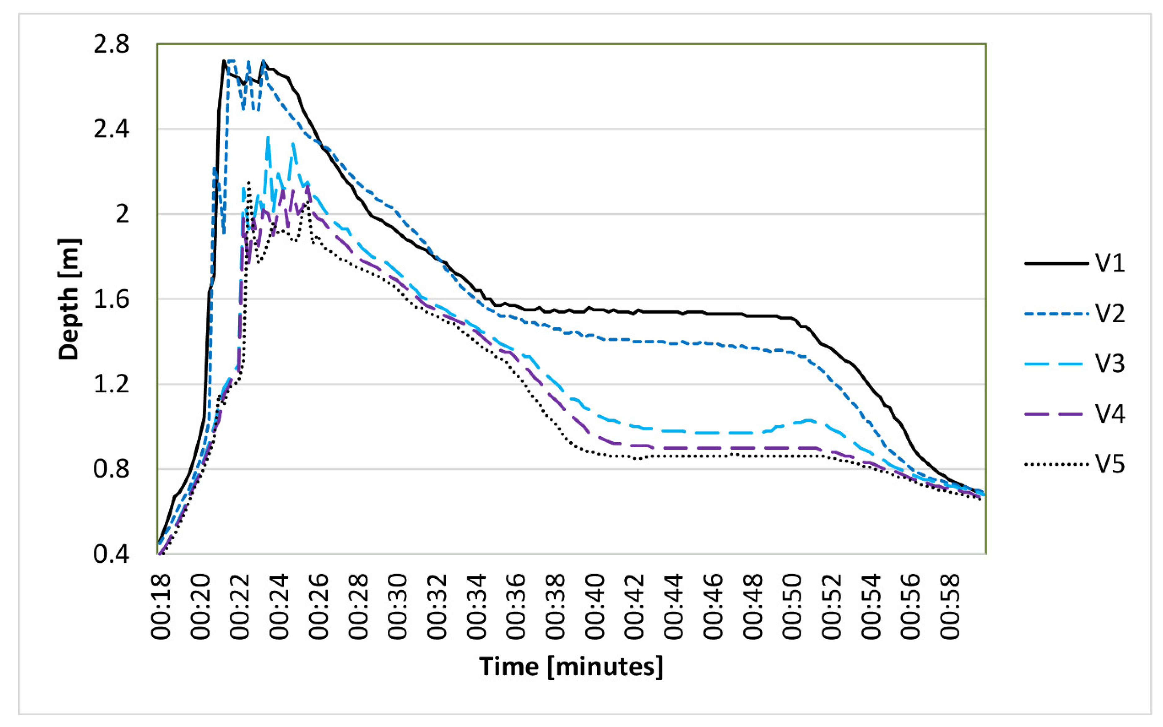
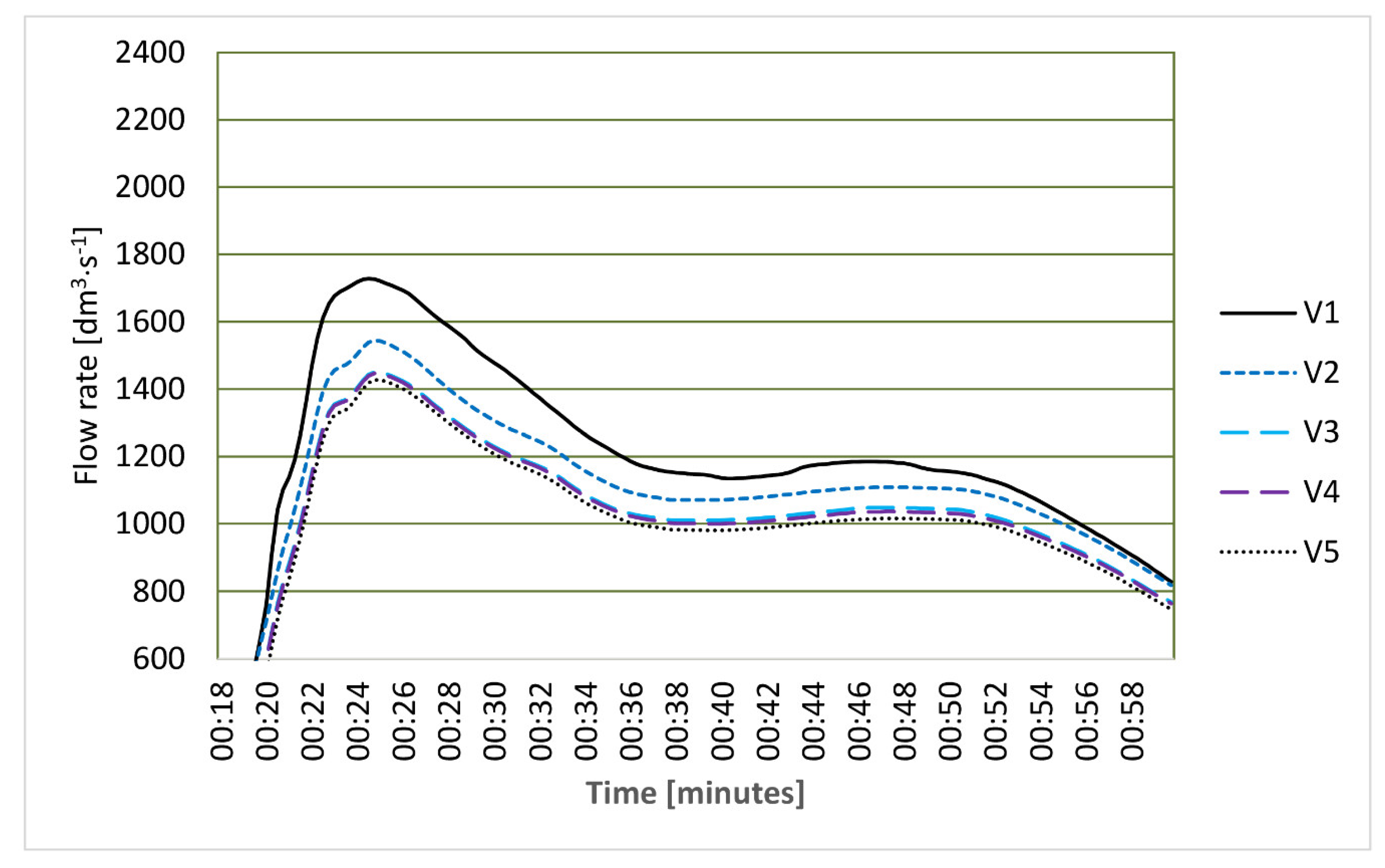
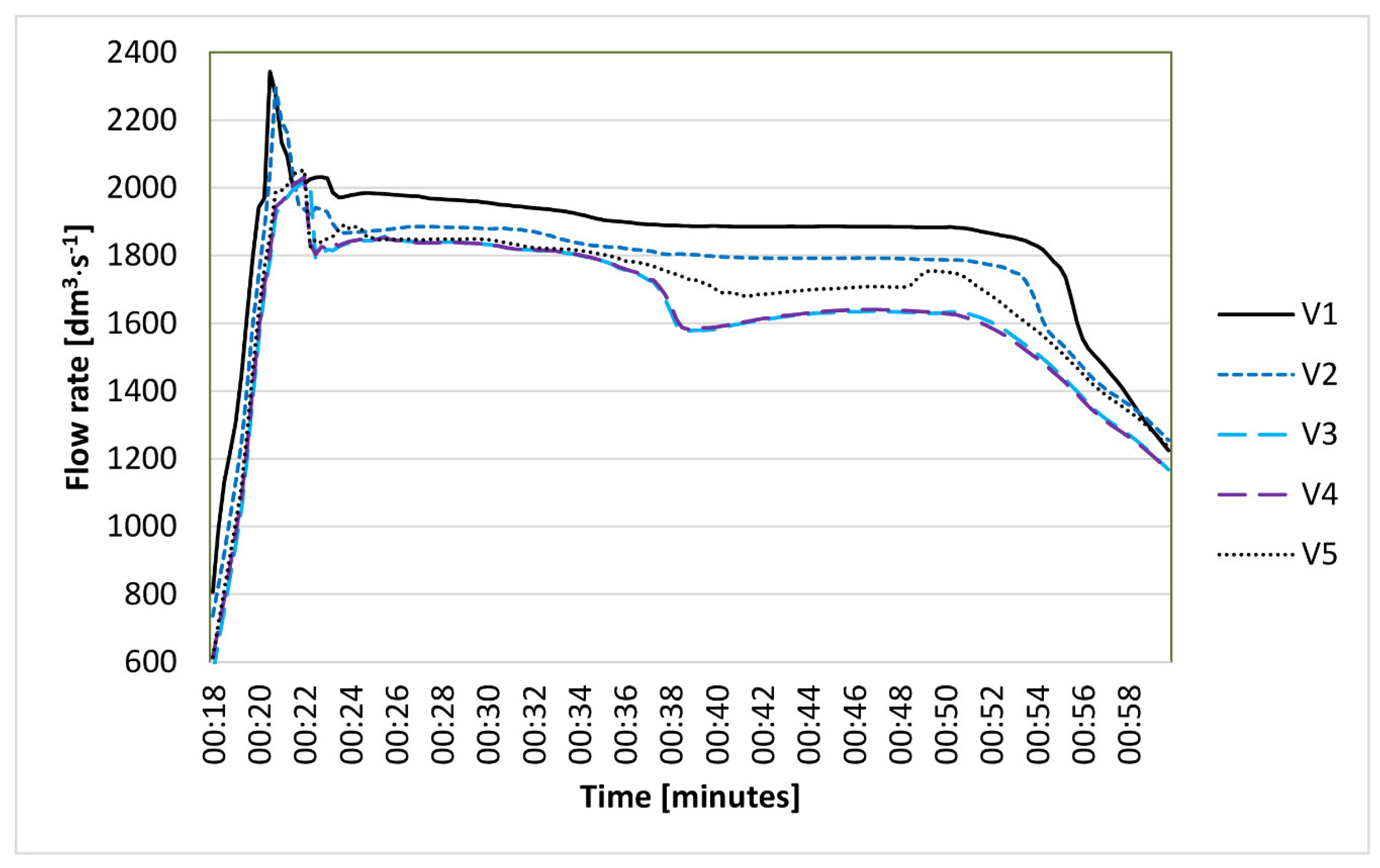
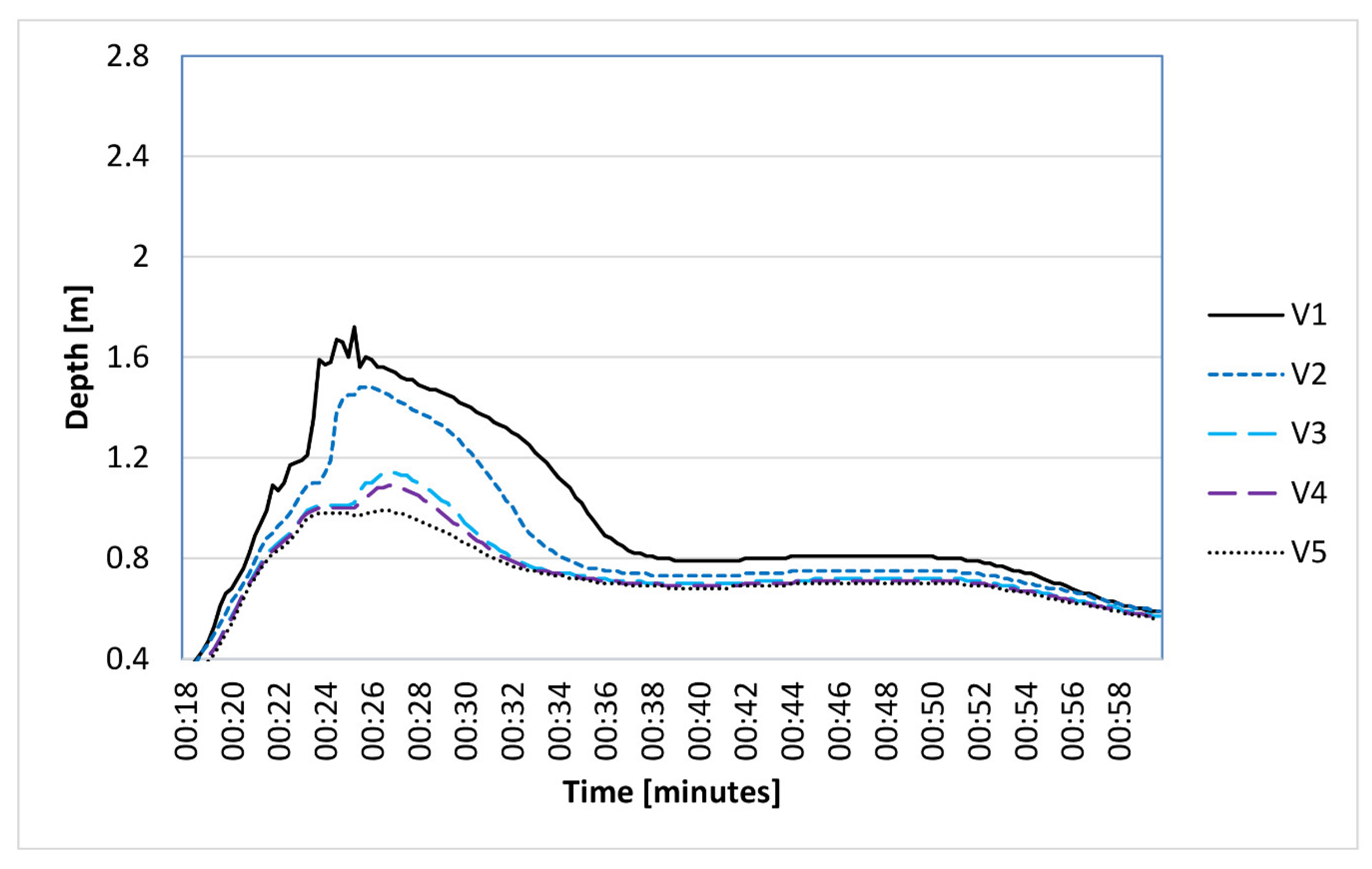
The reporting of results in graphic form was limited to the runoff segment from the area covered by the implementation of LID techniques (Link-30). Figure 10, Figure 11 and Figure 12 present the variability of runoff in a canal related to a rainfall with a frequency of occurrence of F = 2 years (Figure 10), F = 3 years (Figure 11) and F = 5 years (Figure 12). Figure 13, Figure 14 and Figure 15 present the variability of depth in a canal related to a rainfall with a frequency of occurrence of F = 2 years (Figure 13), F = 3 years (Figure 14) and F = 5 years (Figure 15).
Table 2, Table 3 and Table 4 present the estimated reductions of the maximum flow intensity and maximum depth in relation to the base variant. The value of flow intensity and depth was included for the base variant, with the percentage change in relation to the base variant shown for the remaining ones. The compilation was prepared for three calculation sections, the location of which has been marked in Figure 4.
Table 5, Table 6 and Table 7 contain a compilation of the estimated reduction in runoff volume as compared to the base variant. For the base variant, the value of the runoff volume was indicated, whereas in the case of the remaining variants, the percentage change in volume as compared to the base variant was provided.
Table 8 contains a compilation of the estimated reduction in local flooding volume as compared to the base variant. For the base variant, the value of the local flooding volume was indicated, whereas in the case of the remaining variants, the percentage change in volume as compared to the base variant was provided.
Table 9 contains a compilation of the estimated reduction of total outflow volume as compared to the base variant. For the base variant, the value of the total outflow volume was indicated, whereas in the case of the remaining variants, the percentage change in volume as compared to the base variant was provided.
The outflow volume reduction can be interpreted as the part of the total outflow from the catchment that will be managed on site and will not be conveyed by the drainage network to the receiver, the Srebrna stream and then the Warta river.
4. Discussion
Urban flooding is a global problem because rapid urbanization has meant that conventional stormwater management no longer meets the needs of developing liveable and safe cities [42]. Rain gardens and other LID solutions are used worldwide because of their potential to reduce urban runoff, mitigate peak flow and recharge aquifers. In this study, the impact of applying different LIDs in an overloaded urban catchment (rain gardens as domestic facilities are the primary solution) was evaluated. Based on the analysis of charts included in the “Results” chapter, it can be concluded that noticeable differences can already be observed in the case of rainfalls with a lower intensity and higher probability of occurrence [43,44]. This also confirms other results found in literature [45] despite the fact that they were obtained in entirely dissimilar climatic conditions using different LID technologies. The effects of their implementation in this case are more noticeable due to operating under conditions without the overflowing of conduits [27]. The maximum effectiveness of limiting the value of maximum runoff is obtained at F = 2 years. Modernized catchment runoff (Table 3 and Table 4) is limited by 12 to nearly 15% in relation to the base runoff, at a minimum influence of traditional retention. In the case of the frequency of occurrence of model rainfall F = 3, the runoff forms the modernized catchment is limited by 4 to nearly 10% in relation to the base runoff, with a minimal influence of traditional retention allowing for an additional reduction of approx. 3–4% to be attained (Table 3). In the case of a rain model with a 5-year frequency of occurrence, intermediate results were obtained (Table 3). Influence of traditional retention is marginal. The effectiveness of the applied modernization is limited to conduits located directly on the runoff from a modernized catchment. Inflow into the final retention tank, prior to the receiver, is reduced to a maximum of 6% at best (Table 2). In the case of depth analysis, the improvement in conditions is more noticeable (Table 3, Table 4 and Table 5). The largest reductions are observed at F = 3 years (14–42% in Link-30; 19–33% in Link-25). In other cases, it is difficult to find some regularity, nevertheless in most cases the reduction is at least several percent. Here, again, on the inflow to the final retention basin, upstream of the receiver, the reduction is marginal and does not exceed 5%. Similar values were observed for the incidence of F = 3 years. In both cases, the use of LID was clearly more effective. For rainfall events with a frequency of occurrence of F = 5 years, the effectiveness of modernization clearly decreases. The effectiveness of the modernization is limited to the channels located directly on the runoff from the analysed catchment. The reduction of the inflow volume to the final retention basin upstream of the receiver is much smaller compared to the volume obtained in the Link-30 channel.
The obtained results are similar to those obtained by other authors. Ahiableme, Engel and Chaubey [46], under the assumption of different levels of the commonness of applying rain barrels/cisterns and a porous surface, showed a 2–12% reduction in runoff for the two analysed catchments. Zhang, Ye and Shibata indicate a reduction in runoff volume for a catchment in Kyoto, Japan of 12.11–13.78 % [47]. In the analyses described here, smaller values were obtained. This is probably due to the fact that some of the water remaining after a flooding event in the catchment area in the depressions of the terrain. The values obtained for rain gardens are also similar to the examples of using only rain harvesting [40].
In the case of a solution as simple as the application of rain harvesting, home rain gardens or local unsealing of catchment elements, it can be claimed that LID does not create an independent universal solution allowing for peak rainfall runoff to be limited to a level ensuring complete protection from urban flooding. The purpose of LID is to capture the first wave of stormwater and infiltrate it. The presented analysis confirms the necessity of applying hybrid solutions (treatment trains) and the use of every opportunity to retain stormwater. Traditional retention is effective when dealing with rainfall characterized by a low frequency of occurrence, proving to be less and less useful with increasing rainfall intensity. However, this solution will flatten the runoff wave peak and make the runoff longer, but in effect the rainwater will still be discharged to the receiver. The solution will reduce the occurrence of local, uncontrolled flooding, but the effect of gradual drainage of the catchment will still continue. LID techniques, effective in the case of rainfalls with a high intensity, sometimes lose significance as intensity decreases. However, their lower effectiveness does not disqualify such a solution, seeing as how their effect is noticeable even in the case of the most unfavourable variant.
This is confirmed by results presented in other studies [27,48]. Zhu and Chen [27] concluded that, among various parameters, such as: rainfall intensity, the duration of rainfall and the peak rainfall coefficient—the intensity of rainfalls has the highest influence on the effectiveness of LID techniques [45].
The results obtained do not suggest revolutionary changes for the drainage system. The first glance at the graphs in Figure 10, Figure 11 and Figure 12 may even suggest a lack of justification for implementing the proposed technological solutions. However, the profit and loss analysis must cover a wider spectrum of phenomena. As has been mentioned, the system is in operation, currently overloaded with rainwater inflows. On the basis of the data presented in Table 8, another positive effect is the significant reduction in potential local flooding by more than 60%, even in the case of the highest rainfall intensity analysed and can reach up to 70% for frequency F = 2 years. The results obtained indicate low effectiveness of the proposed solution in the case of prolonged outflow time to the receiver. Delay of 2–3 min with the duration of model rainfall of 45 min indicates the necessity to consider the location of larger retention reservoirs retaining rainwater from municipal areas. If LID is used, in the extreme case, it is possible to retain as much as 4.7 to 6.7% of the baseline runoff from the entire sewer system analysed.
The results of the work are important from a practical point of view, especially in the case of existing, usually overloaded systems. When it comes to designing new systems, the possibility of obtaining positive results of implementation is much higher, thanks to the fact that:
- the introduction of LID solutions, such as rain barrels, rain gardens or different forms of infiltration, is possible at the planning, design and realization stage;
- it is possible to correlate design activities in the scope of planned and realized works in common areas (municipal, common areas of communes, etc.) and at the border of properties and urban areas—for example, unsealed driveways from the roadway to the garage gate.
5. Conclusions
The results obtained as an effect of the works carried out allowed for the following conclusions to be drawn:
- reducing the flow rate and depth (surcharge) in the stormwater network facilitates is conducive to reducing the scale of local flooding, especially during low intensity rainfalls events;
- the application of LID in connection with classical methods allowing for stormwater runoff to be delayed has a significant influence on protecting the receiver; among others, by decreasing the flow intensity in canals, it facilitates the reduction of the leaching of contaminants found the stormwater network and reduces the hydraulic and quality load on the receiver;
- runoff in the case of a dispersed manner of applying LID fulfils the condition of partially returning the natural water cycle in the catchment; this is done directly when dealing with rain gardens and other solutions based on infiltration;
- the application of LID may be treated as a universal solution allowing for urban floods or the local flooding of the area or buildings to be prevented only in the case of a stormwater system designed and constructed under assumptions accounting for climate changes and rigorous maintenance of a constant level of imperviousness in the urban catchment area;
- an optimal solution is applying LID elements in a dispersed manner, realized alongside classical solutions, such as retention in tanks, retention in conduits, or introducing elements which direct the flow of stormwater. This is confirmed by the results obtained by Damodaram et al. [14], Liu et al. [20], Xie et al. [49] and Alves et al. [50]. Designing such a "hybrid" system must be preceded by a detailed analysis of the terrain, geological and hydrological possibilities and ensuring appropriate hydraulic conditions for the flow in canals and network facilities (maintaining optimum flow velocity and avoiding surcharging of elements of the drainage system);
- the analysed solutions, whether this be rain gardens or combinations of several solutions, are largely similar from a hydraulic point of view and it is thus, possible to adapt the selection of individual choices based on the individual preferences of the inhabitant, or even applying both solutions concurrently;
- LID solutions ought to be, whenever possible, looked into at the stage of planning the development of the land infrastructure; in areas that are already built-up, the possibilities for their realization drop drastically. Investors and land plot owners will, for the most part, not change their attitude unless financial encouragement programs are implemented.
Summing up, it can be concluded that LID techniques are an important step on the road to recreating the natural water cycle in a catchment in urbanized areas. The issue is significant due to the increasing noticeable influence of climatic changes on the frequency and intensity of extreme rainfalls [53]. The benefits of applying such solutions ought to be looked into not only as an economic aspect; they should also be supported by a hydraulic analysis and an analysis of their influence on the environment. An important issue is both the protection of the receiver from excessive runoff, as well as the successive (in the case of the existing development) return of the natural water cycle in the urban catchment. The issue of safety of the drainage basin and property of the residents living in its area is also important. This undertaking cannot be realized without raising social awareness of real estate owners as well as implementing solutions at the level of local governments [54,55,56]. Compelling investors, including commercial ones such as developers, to create an adequate, clearly defined infrastructure in built-up areas will make it possible to avoid the implementation of irrational, make-shift solutions of dealing with problems connected with local flooding. The provisional solving of problems without a global vision and analysis of a large area may have negative effects in the form of carrying over the consequences of certain phenomena to neighbouring catchments and may thus lead to conflicts between the owners, or even to lawsuits.
The optimum solution is to adopt guidelines at the national level and by local government units for sustainable stormwater management. On the other hand, government units should also be equipped with tools which make it possible to enforce the assumptions imposed at the stage of issuing building permits by oversight during the realization of the investment. Positive results obtained in the pilot area as well as potential observable limitations of the scope of local flooding may be an impulse which makes it possible to persuade a larger amount of inhabitants to invest in the implementation of LID in their area [57]. In extreme cases, it is necessary to impose certain initial conditions in the existing systems, e.g., [6]:
- introducing of national and local limitations connected with the drainage of stormwater into the stormwater sewer network [58];
- raising social awareness on making use of rainwater on private properties and in common residential areas [59], supported by implementing a program of financial initiatives as economic supplementation and support for investment at the border of the property and municipal area.
It would be very difficult to identify fully implementable rules for different regions of the world. The obstacles include large differences in precipitation characteristics—Zhang et al. [42] analyse rains of intensity over 100 mm/h, in Lubuskie Province the record is less than 100 mm per day. As a consequence, diametrically different precipitation models are used and it is sometimes necessary to design several times larger objects.
The use of LID technology is an important step towards partial restoring the natural water cycle in the catchment area in urbanised areas. However, in the case of existing systems with an overloaded sewer network, it is not a means of protection against flooding in urbanised areas without the synchronous implementation of classic retention tanks. It has been shown that a rain garden of about 12 m2 or a similar solution of similar area should be designed to achieve acceptable efficiency. The rain garden can be incorporated into the plot development project by selecting appropriate plants. The rain garden and other infiltration-based LIDs are essentially maintenance-free, so the negative impact of errors in the operation of harvesting solutions is limited.
The presented analysis does not exhaust the topic of applying LID techniques in existing systems operating under unfavourable hydraulic and hydrological conditions. A further step will be carrying out an assessment of the possibility to locate centralized LIDs such as civic water storage tanks or cisterns, replacing or supplementing individual structures for storing stormwater. An advantage of such a solution will surely be the possibility to service a larger sealed catchment [22] and provide hydraulic relief to a larger rain system [53]. In addition, also planned is the use of field measurements realized prior to and after implementing the pilot program of at-home rain gardens, infiltration trenches and rain barrels, making use of actual rainfall data measured in the catchment [60]. As already mentioned, the problem of local flooding as a result of excessive sealing of urban catchments is not a local problem, but concerns cities in countries almost all over the world [40,42]. Ironically, such problems affect not only densely built-up areas [42], but also typical suburban areas with relatively low-density housing [40]. The widespread rainwater management, e.g., through the use of LID, is observed in many countries [9,47], but it is not everywhere accepted or recommended as it is in countries that do well in this field. An example are the countries of Central and Eastern Europe, including Poland, where only individual cities are implementing more or less advanced solutions and national projects are just starting. In general, LID solutions such as rain gardens, infiltration trenches or pavement unsealing in Gorzów Wielkopolski can be considered useful in reducing the risk of flooding associated with storm water. These facilities can be taken into account in urban planning in Poland and other cities in the world with similar climatic conditions.
Funding
This research received no external funding. The APC was funded by the Marshal’s Office of Lubuskie Province in the framework of the competition Small Grants for Public Universities from Lubuskie.
Data Availability Statement
Data presented in this study are available on request from the corresponding author. The data are not publicly available due to internal regulations of the University of Zielona Góra.
Conflicts of Interest
The author declares no conflict of interest.
References
- Suchocka, M.; Siedlecka, M. Vegetation as an important element of precipitation water management on urban areas (Roślinność jako ważny element systemu gospodarowania wodami opadowymi na terenach miejskich). Drogownictwo 2017, 7–8, 236–243. [Google Scholar]
- Palla, A.; Gnecco, I. Hydrologic modeling of Low Impact Development systems at the urban catchment scale. J. Hydrol. 2015, 528, 361–368. [Google Scholar] [CrossRef]
- Eckart, K.; McPhee, Z.; Bolisetti, T. Multiobjective optimization of low impact development stormwater controls. J. Hydrol. 2018, 562, 564–576. [Google Scholar] [CrossRef]
- Berndtsson, R.; Becker, P.; Persson, A.; Aspegren, H.; Haghighatafshar, S.; Jönsson, K.; Larsson, R.; Mobini, S.; Mottaghi, M.; Nilsson, J.; et al. Drivers of changing urban flood risk: A framework for action. J. Environ. Manag. 2019, 240, 47–56. [Google Scholar] [CrossRef] [PubMed]
- Eckart, K.; McPhee, Z.; Bolisetti, T. Performance and implementation of low impact development A review. Sci. Environ. 2017, 607–608, 413–432. [Google Scholar] [CrossRef]
- Fletcher, T.D.; Shuster, W.; Hunt, W.F.; Ashley, R.; Butler, D.; Arthur, S.; Trowsdale, S.; Barraud, S.; Semadeni-Davies, A.; Bertrand-Krajewski, J.L.; et al. SUDS, LID, BMPs, WSUD and more The evolution and application of terminology surrounding urban drainage. Urban Water J. 2015, 12, 525–542. [Google Scholar] [CrossRef]
- Tahvonen, O.; Airaksinen, M. Low-density housing in sustainable urban planning Scaling down to private gardens by using the green infrastructure concept. Land Use Policy 2018, 75, 478–485. [Google Scholar] [CrossRef]
- Coffman, L. Low-Impact Development Design Strategies; An Integrated Design Approach (Report). EPA 841-B-00-003; Department of Environmental Resources, Programs and Planning Division: Prince George’s County, MD, USA, 2000; pp. 25–45.
- Woods-Ballard, B.; Wilson, S.; Udale-Clarke, H.; Illman, S.; Scott, T.; Ashley, R.; Kellagher, R. The SuDS Manual; CIRIA: London, UK, 2015; pp. 19–30. [Google Scholar]
- Zhong, R.; Xu, M.; Vieira Netto, R.; Wille, K. Influence of pore tortuosity on hydraulic conductivity of pervious concrete: Characterization and modeling. Constr. Build. Mater. 2016, 125, 1158–1168. [Google Scholar] [CrossRef]
- Suripin, S.; Sangkawati, S.S.; Pranoto, S.A.; Sutarto, E.; Hary, B.; Dwi, K. Reducing Stormwater Runoff from Parking Lot with Permeable Pavement. E3S Web Conf. 2018, 73, 05016. [Google Scholar] [CrossRef] [Green Version]
- Mao, X.; Jia, H.; Yu, S.L. Assessing the ecological benefits of aggregate LID-BMPs through modelling. Ecol. Model. 2017, 353, 139–149. [Google Scholar] [CrossRef]
- Li, Q.; Wang, F.; Yu, Y.; Huang, Z.; Li, M.; Guan, Y. Comprehensive performance evaluation of LID practices for the sponge city construction: A case study in Guangxi, China. J. Environ. Manag. 2019, 231, 10–20. [Google Scholar] [CrossRef]
- Damodaram, C.; Giacomoni, M.H.; Khedun, C.P.; Holmes, H.; Ryan, A.; Saour, Q.; Zechman, E.M. Simulation of combined best management practices and low impact development for sustainable stormwater management. J. Am. Water Resour. Assoc. 2010, 46, 907–918. [Google Scholar] [CrossRef]
- Zimmer, C.A.; Heathcote, I.W.; Whiteley, H.R.; Schroeter, H. Low Impact Development Practices for Stormwater Implications for Urban Hydrology. Can. Water Resour. J. 2007, 32, 193–212. [Google Scholar] [CrossRef]
- Jia, H.; Lu, Y.; Yu, S.L.; Chen, Y. Planning of LID–BMPs for urban runoff control: The case of Beijing Olympic Village. Sep. Purif. Technol. 2012, 84, 112–119. [Google Scholar] [CrossRef]
- Bąk, J. Modelling the relationship between LID practices and the runoff of rainwater through the example of rainfall data for Krakow. E3s Web Conf. 2018, 45. [Google Scholar] [CrossRef] [Green Version]
- Mrowiec, M.; Sobczyk, M. Ecological management of rainwaters green roofs. Water-Environ. Rural Areas 2014, 48, 53–61. [Google Scholar]
- Olorunkiya, J.; Fassman, E.; Wilkinson, S. Risk: A Fundamental Barrier to the Implementation of Low Impact Design Infrastructure for Urban Stormwater Control. J. Sustain. Dev. 2012, 5, 27–41. [Google Scholar] [CrossRef]
- Liu, Y.; Bralts, V.F.; Engel, B.A. Evaluating the effectiveness of management practices on hydrology and water quality at watershed scale with a rainfall-runoff model. Sci. Total Environ. 2015, 511, 298–308. [Google Scholar] [CrossRef] [PubMed]
- Huang, C.L.; Hsu, N.S.; Liu, H.J.; Huang, Y.H. Optimization of low impact development layout designs for megacity flood mitigation. J. Hydrol. 2018, 564, 542–558. [Google Scholar] [CrossRef]
- Basdeki, A.; Katsifarakis, L.; Katsifarakis, K.L. Rain Gardens as Integral Parts of Urban Sewage Systems-a Case Study in Thessaloniki, Greece. Procedia Eng. 2016, 162, 426–432. [Google Scholar] [CrossRef] [Green Version]
- Strecker, E.; Huber, W.; Heaney, J.; Bodine, D.; Sansalone, J.; Quigley, M.; Leisenring, M.; Pankani, D.; Thayumanavan, A. Critical Assessment of Stormwater Treatment and Control Selection Issues. Final Report to the Water Environment Research Foundation, WERF 02-SW-1. 2005. Available online: http://documents.irevues.inist.fr/bitstream/handle/2042/25192/0263_269strecker.pdf?sequence=1(accessed on 16 March 2019).
- RainGardens.info. Available online: https://raingardens.info/ (accessed on 15 May 2020).
- Raingardens. Melbourne Waters. Available online: https://www.melbournewater.com.au/media/452/download (accessed on 15 May 2020).
- Ogrody Deszczowe w Gruncie. Instrukcja Budowy (in Polish). Sendzimir Foundation. Available online: https://sendzimir.org.pl/publikacje/broszury-instruktazowe-dot-zwiekszania-retencji-krajobrazowej/ (accessed on 28 December 2020).
- Zhu, Z.; Chen, X. Evaluating the Effects of Low Impact Development Practices on Urban Flooding under Different Rainfall Intensities. Water 2017, 9, 548. [Google Scholar] [CrossRef]
- Kong, F.; Ban, Y.; Yin, H.; James, P.; Dronova, I. Modeling stormwater management at the city district level in response to changes in land use and low impact development. Environ. Model. Softw. 2017, 95, 132–142. [Google Scholar] [CrossRef]
- Bosley, E.K., II. Hydrologic Evaluation of Low Impact Development Using a Continuous, Spatially-distributed Model. Master’s Thesis, Virginia Polytechnic Institute and State University, Blacksburg, VA, USA, 2008. Available online: https://www.researchgate.net/publication/265824795_Hydrologic_Evaluation_of_Low_Impact_Development_Using_a_Continuous_Spatially-Distributed_Model_in_Memoriam (accessed on 16 March 2019).
- Granata, F.; Gargano, R.; de Marinis, G. Support Vector Regression for Rainfall-Runoff Modeling in Urban Drainage: A Comparison with the EPA’s Storm Water Management Model. Water 2016, 8, 69. [Google Scholar] [CrossRef]
- Nowogoński, I.; Ogiołda, E. Verification of the combined sewage system simulation model based on the example of the city of Głogów. E3s Web Conf. 2018, 45. [Google Scholar] [CrossRef] [Green Version]
- Rossman, L.A. Modeling Low Impact Development Alternatives with SWMM. J. Water Manag. Modeling 2010, 18, 167–182. [Google Scholar] [CrossRef] [Green Version]
- Zhu, Z.; Chen, Z.; Chen, X.; Yu, G. An assessment of the hydrologic effectiveness of low impact development (LID) practices for managing runoff with different objectives. J. Environ. Manag. 2019, 231, 504–514. [Google Scholar] [CrossRef]
- Brunetti, G.; Šimůnek, J.; Turco, M.; Piro, P. On the use of surrogate-based modeling for the numerical analysis of Low Impact Development techniques. J. Hydrol. 2017, 548, 263–277. [Google Scholar] [CrossRef] [Green Version]
- Brunetti, G.; Šimůnek, J.; Bogena, H.; Baatz, R.; Huisman, J.A.; Dahlke, H.; Vereecken, H. On the information content of cosmic-ray neutron data in the inverse estimation of soil hydraulic properties. Vadose Zone J. 2019, 18. [Google Scholar] [CrossRef] [Green Version]
- Turco, M.; Brunetti, G.; Carbone, M.; Piro, P. Modelling the hydraulic behaviour of permeable pavements through a reservoir element model. In Proceedings of the International Multidisciplinary Scientific GeoConference Surveying Geology and Mining Ecology Management, Sofia, Bulgaria, 2–8 July 2018; pp. 507–514. [Google Scholar] [CrossRef]
- Nowogoński, I.; Ogiołda, E. Modelling technique of interaction between pressure and gravity sewage systems. E3s Web Conf. 2018, 44. [Google Scholar] [CrossRef] [Green Version]
- Rossman, L.A. Storm Water Management Model User’s Manual Version 5.1, [EPA/600/R-14/413b; US EPA National Risk Management Research Laboratory: Cincinnati, OH, USA, 2015; pp. 46–79.
- Krebs, G.; Kokkonen, T.; Valtanen, M.; Setälä, H.; Koivusalo, H. Spatial resolution considerations for urban hydrological modelling. J. Hydrol. 2014, 512, 482–497. [Google Scholar] [CrossRef]
- Nowogoński, I. Low impact development modeling to manage urban stormwater runoff: Case study of Gorzów Wielkopolski. J. Environ. Eng. Landsc. Manag. 2020, 28, 105–115. [Google Scholar] [CrossRef]
- Bogdanowicz, E.; Stachý, J. Maximum rainfall in Poland—a design approach. In The Extremes of the Extremes: Extraordinary Floods; Snorasson, A., Finnsdottir, H.P., Moss, M., Eds.; IAHS Publication: Reykjavik, Iceland, 2002; Volume 171, pp. 15–18. [Google Scholar]
- Zhang, L.; Oyake, Y.; Morimoto, Y.; Niwa, H.; Shibata, S. Flood mitigation function of rain gardens for management of urban storm runoff in Japan. Landsc. Ecol. Eng. 2020, 16, 223–232. [Google Scholar] [CrossRef]
- Jia, Z.; Tang, S.; Luo, W.; Li, S.; Zhou, M. Small scale green infrastructure design to meet different urban hydrological criteria. J. Environ. Manag. 2016, 171, 92–100. [Google Scholar] [CrossRef]
- Li, H.; Sharkey, L.J.; Hunt, W.F.; Davis, A.P. Mitigation of impervious surface hydrology using bio-retention in North Carolina and Maryland. J. Hydrol. Eng. 2009, 14, 407–415. [Google Scholar] [CrossRef] [Green Version]
- Shafique, M.; Kim, R.; Kyung-Ho, K. Green Roof for Stormwater Management in a Highly Urbanized Area: The Case of Seoul, Korea. Sustainability 2018, 10, 584. [Google Scholar] [CrossRef] [Green Version]
- Ahiableme, L.M.; Engel, B.A.; Chaubey, I. Effectiveness of low impact development practices in two urbanized watersheds: Retrofitting with rain barrel/cistern and porous pavement. J. Environ. Manag. 2013, 119, 151–161. [Google Scholar] [CrossRef] [PubMed]
- Zhang, L.; Ye, Z.; Shibata, S. Assessment of rain garden effects for the management of urban storm runoff in Japan. Sustainability 2020, 12, 9982. [Google Scholar] [CrossRef]
- Seo, M.; Jaber, F.; Srinivasan, R.; Jeong, J. Evaluating the Impact of Low Impact Development (LID) Practices on Water Quantity and Quality under Different Development Designs Using SWAT. Water 2017, 9, 193. [Google Scholar] [CrossRef]
- Xie, J.; Chen, H.; Liao, Z.; Gu, X.; Zhu, D.; Zhang, J. An integrated assessment of urban flooding mitigation strategies for robust decision making. Environ. Model. Softw. 2017, 95, 143–155. [Google Scholar] [CrossRef]
- Alves, A.; Gersonius, B.; Sanchez, A.; Vojinovic, Z.; Kapelan, K. Multi-criteria Approach for Selection of Green and Grey Infrastructure to Reduce Flood Risk and Increase CO-benefits. Water Resour. Manag. 2018, 32, 2505–2522. [Google Scholar] [CrossRef]
- La Rosa, D.; Pappalardo, V. Planning for spatial equity A performance based approach for sustainable urban drainage systems. Sustain. Cities Soc. 2019. [Google Scholar] [CrossRef]
- Anim, D.O.; Fletcher, T.D.; Pasternack, G.B.; Vietz, G.J.; Duncan, H.P.; Burns, M.J. Can catchment-scale urban stormwater management measures benefit the stream hydraulic environment? J. Environ. Manag. 2019, 233, 1–11. [Google Scholar] [CrossRef] [PubMed]
- Srishantha, U.; Rathnayake, U. Sustainable urban drainage systems (SUDS) what it is and where do we stand today? Eng. Appl. Sci. Res. 2017, 44, 235–241. [Google Scholar] [CrossRef]
- Church, S.P. Exploring Green Streets and rain gardens as instances of small scale nature and environmental learning tools. Landsc. Urban Plan. 2015, 134, 229–240. [Google Scholar] [CrossRef]
- Kim, S.; An, K. Exploring Psychological and Aesthetic Approaches of Bio-Retention Facilities in the Urban Open Space. Sustainability 2017, 9, 2067. [Google Scholar] [CrossRef] [Green Version]
- Chang, N.B.; Lu, J.W.; Chui, T.F.M.; Hartshorn, N. Global policy analysis of low impact development for stormwater management in urban regions. Land Use Policy 2018, 70, 368–383. [Google Scholar] [CrossRef]
- Pappalardo, V.; La Rosa, D. Policies for sustainable drainage systems in urban contexts within performance-based planning approaches. Sustain. Cities Soc. 2020, 52. [Google Scholar] [CrossRef]
- Goulden, S.; Portman, M.E.; Carmon, N.; Alon-Mozes, T. From conventional drainage to sustainable stormwater management: Beyond the technical challenges. J. Environ. Manag. 2018, 219, 37–45. [Google Scholar] [CrossRef] [PubMed]
- Mahauta, H.; Andrieub, H. Relative influence of urban-development strategies and water management on mixed (separated and combined) sewer overflows in the context of climate change and population growth: A case study in Nantes. Sustain. Cities Soc. 2019, 44, 171–182. [Google Scholar] [CrossRef]
- Ahmed, K.; Chung, E.S.; Song, J.Y.; Shahid, S. Effective Design and Planning Specification of Low Impact Development Practices Using Water Management Analysis Module (WMAM): Case of Malaysia. Water 2017, 9, 173. [Google Scholar] [CrossRef] [Green Version]
Figure 1.
Example of rainwater permeable parking places—Zielona Góra, Cisowa Street.
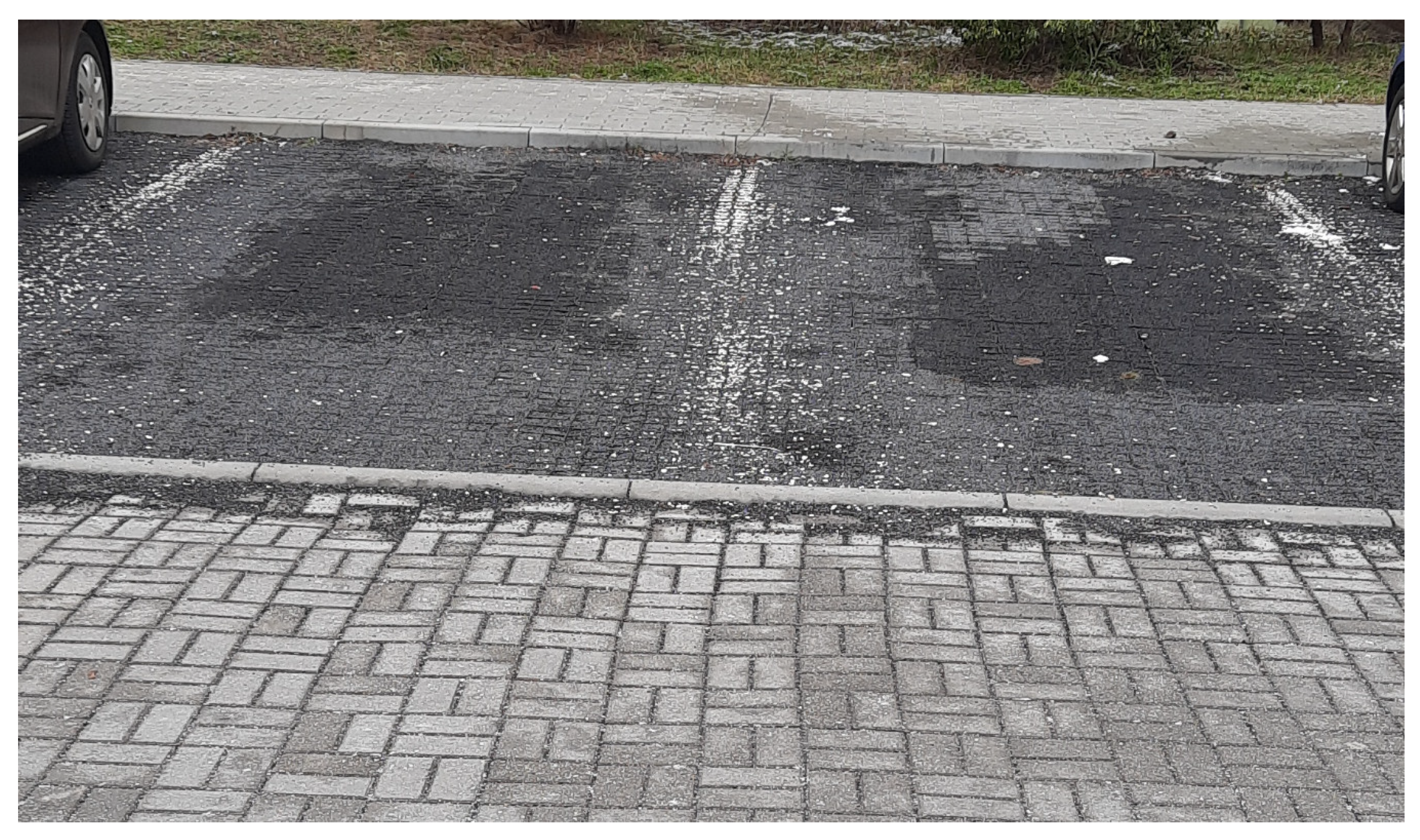
Figure 2.
Example of rainwater permeable parking places and manoeuvring area—Zielona Góra, Cisowa Street.
Figure 2.
Example of rainwater permeable parking places and manoeuvring area—Zielona Góra, Cisowa Street.
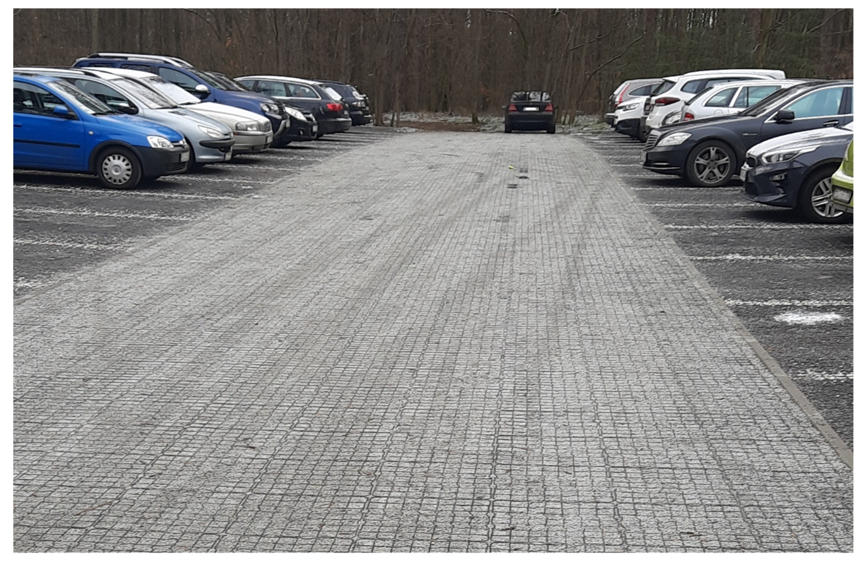
Figure 3.
Location of the analysed object—Gorzów Wielkopolski (Lubuskie Province).

Figure 4.
Scheme of existing stormwater drainage system and rainwater catchments connected to junctions with the analysed sections marked as Link-3, Link-25 and Link-30 [40].
Figure 4.
Scheme of existing stormwater drainage system and rainwater catchments connected to junctions with the analysed sections marked as Link-3, Link-25 and Link-30 [40].

Figure 5.
Representation of the underground retention tank in the Storm Water Management Model (SWMM) software by U.S. Environmental Protection Agency.
Figure 5.
Representation of the underground retention tank in the Storm Water Management Model (SWMM) software by U.S. Environmental Protection Agency.

Figure 6.
Rainfall scheme of Euler type II model—duration 45 min. (frequency of occurrence of modelled rainfall F = 2) [40,41].
Figure 7.
Rainfall scheme of Euler type II model—duration 45 min. (frequency of occurrence of modelled rainfall F = 3) [40,41].
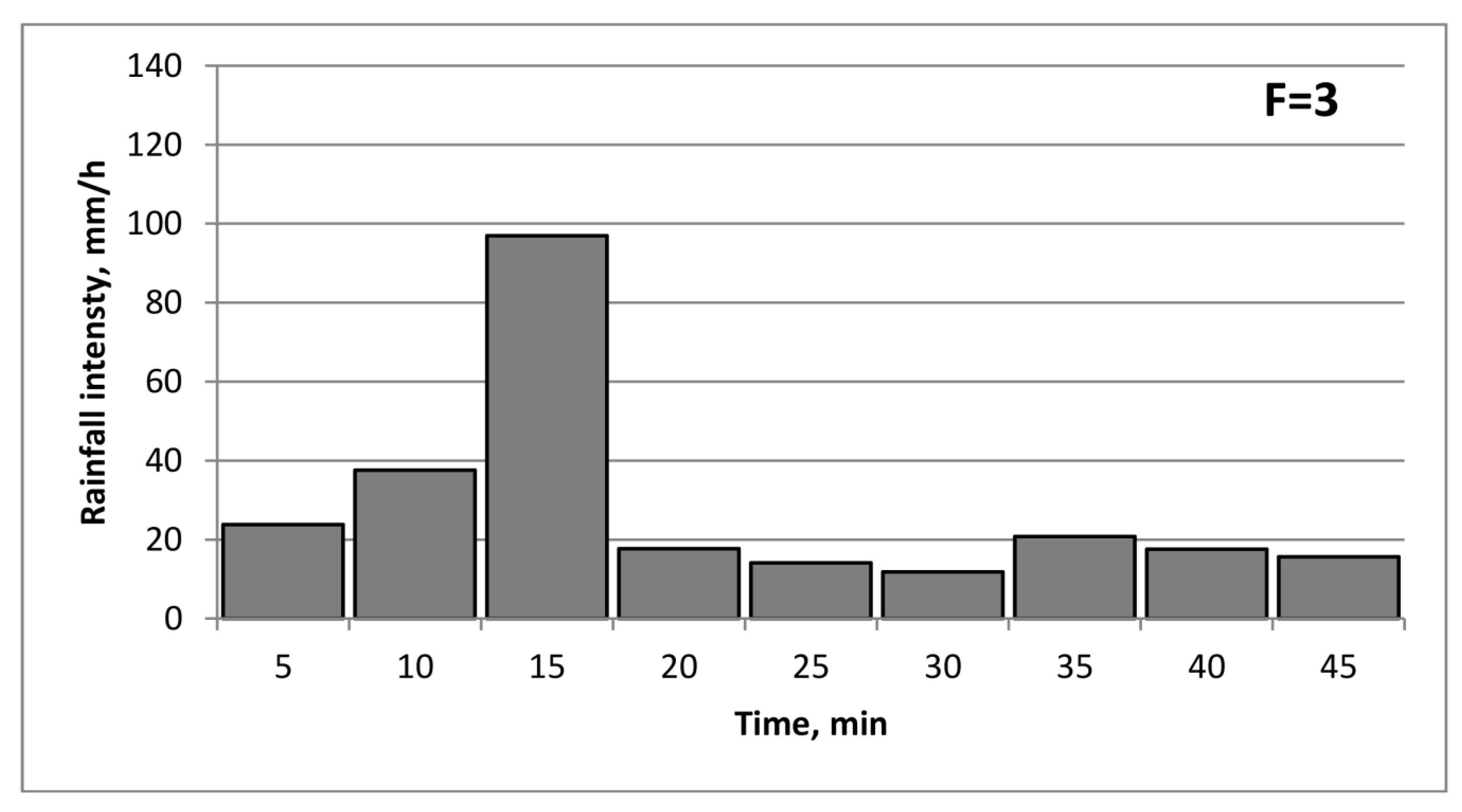
Figure 8.
Rainfall scheme of Euler type II model—duration 45 min. (frequency of occurrence of modelled rainfall F = 5) [40,41].
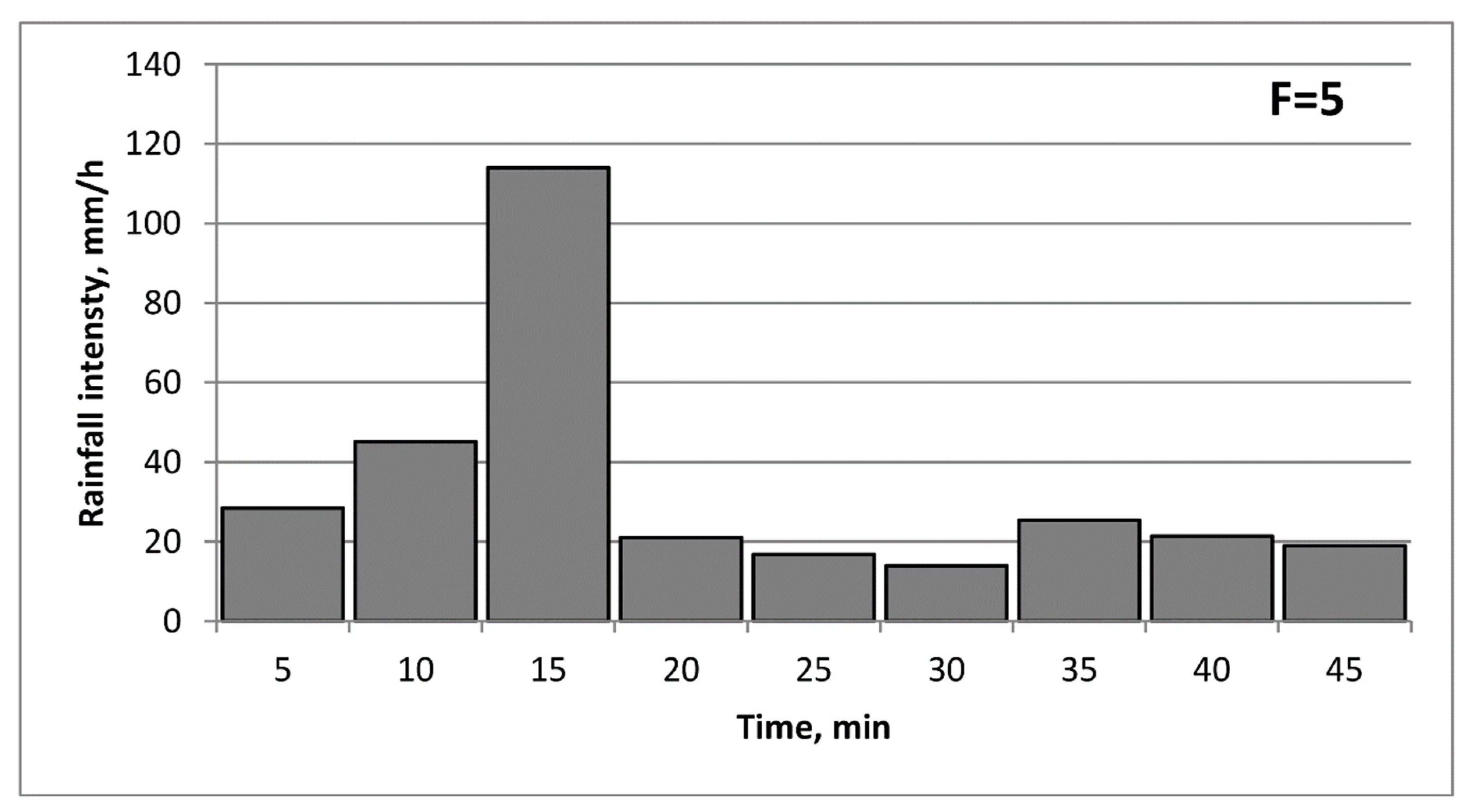
Figure 9.
Terraced houses with pitched roofs.

Figure 10.
Change in flow rate in Link-30 canal—F = 2 years.

Figure 11.
Change in flow rate in Link-30—F = 3 years.
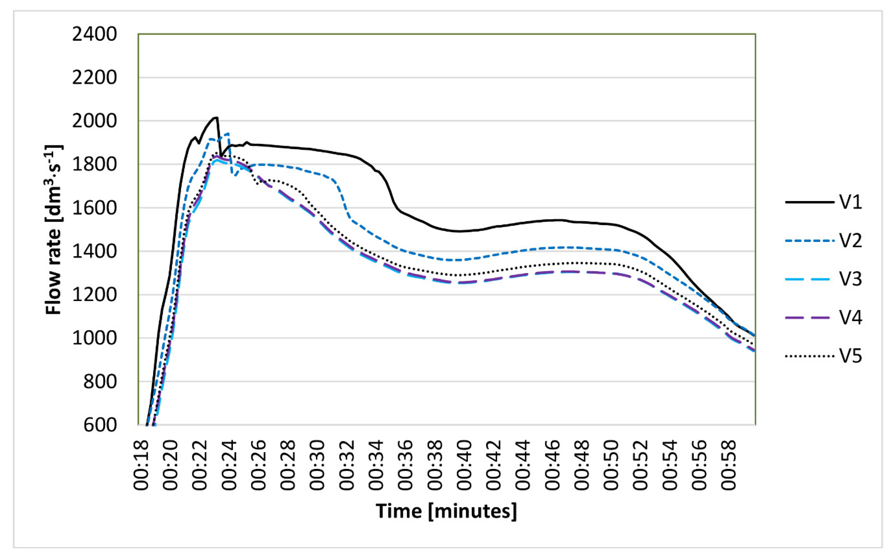
Figure 12.
Change in flow rate in Link 30 canal—F = 5 years.

Figure 13.
Depth change in Link-30 canal—F = 2 years.
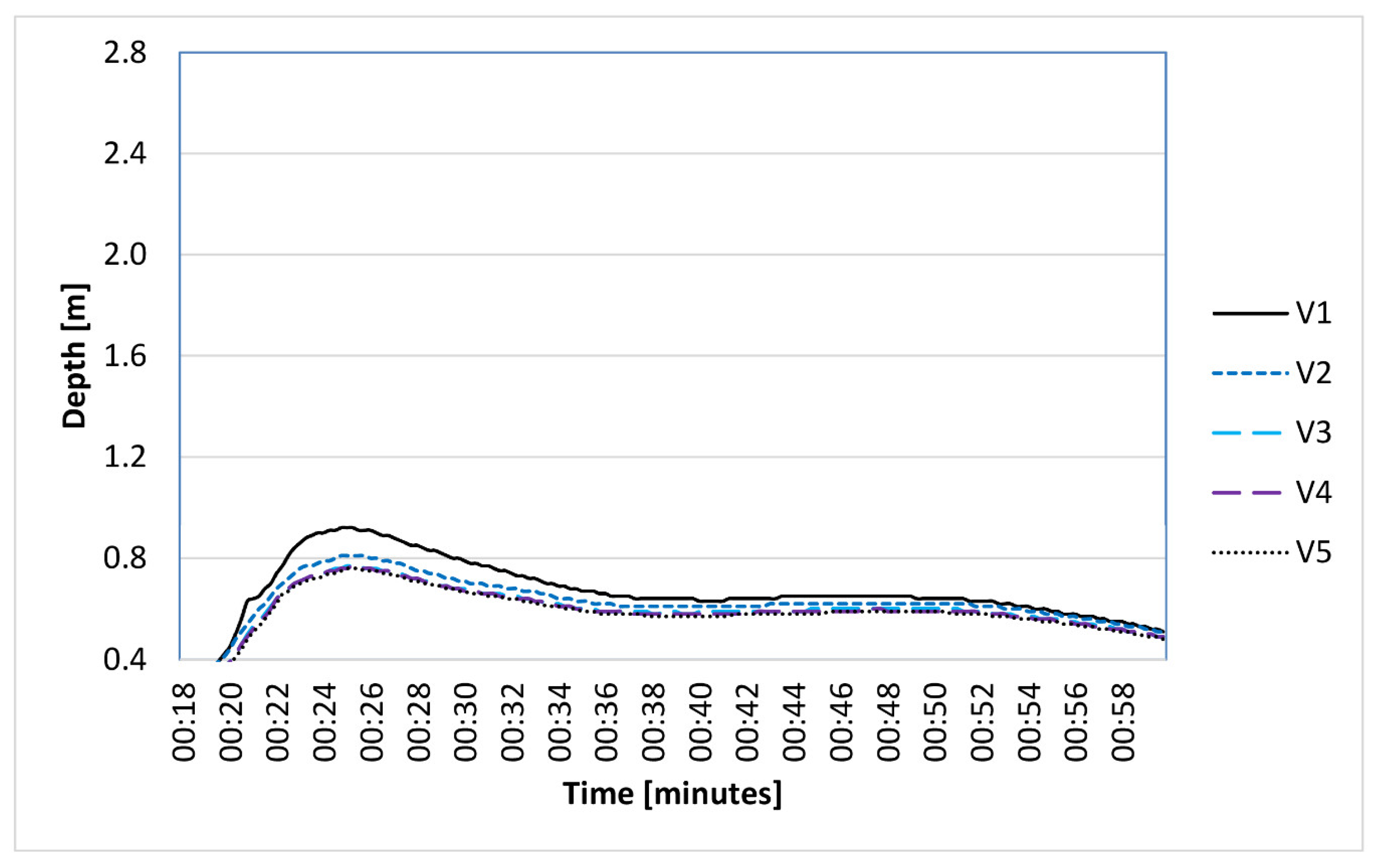
Figure 14.
Depth change in Link-30 canal—F = 3 years.

Figure 15.
Depth change in Link-30 canal—F = 5 years.

Table 1.
Selected suggestions for planting in UK conditions [24].
Table 1.
Selected suggestions for planting in UK conditions [24].
| Habit | Common Name | Scientific Name |
|---|---|---|
| Bulbous perennials | Garlic and onions | Allium spp. |
| Fern | Royal fern | Osmunda regalis |
| Male fern | Dryopteris felix-mas | |
| Broad buckler fern | Dryopteris dilatata | |
| Grass | Switch grass | Panicum virgatum |
| Zebra grass | Miscanthis sinensis | |
| Herbaceous perennial | Culvers root | Veronicastrum virginicum |
| Aster | Aster spp. | |
| Stinking hellebore | Helleborus foetidus | |
| Columbine | Aquilegia spp. | |
| Inula | Inula hookeri | |
| Hemp agrimony | Eupatorium cannabinum | |
| Bellflower | Campanula glomerata | |
| Sneezeweed | Helenium sp. | |
| Plantain lilies | Hosta spp. | |
| Shrub | Guelder rose | Viburnum opulus |
| Dogwood | Cornus sanguinea | |
| Lesser periwinkle | Vinca minor | |
| Rhizomatous perennial | Bugle | Ajuga reptans |
| Elephants ear | Bergenia sp. | |
| Yellow flag | Iris pseudocorus | |
| Siberian flag | Iris sibirica | |
| Pendulous sedge | Carex pendula |
Table 2.
Reduction of the maximum flow intensity and maximum depth in relation to the base variant—Link-3 calculation segment.
Table 2.
Reduction of the maximum flow intensity and maximum depth in relation to the base variant—Link-3 calculation segment.
| Link-3 | Frequency of Model Rainfall | |||||
|---|---|---|---|---|---|---|
| 2 Years | 3 Years | 5 Years | ||||
| Q dm3·s−1 | H m | Q dm3·s−1 | H m | Q dm3·s−1 | H m | |
| Variant V1 | 2016.25 | 0.65 | 2331.69 | 0.72 | 2709.16 | 0.82 |
| Variant V2, % | 3.3 | 1.5 | −0.9 | −1.4 | −1.2 | −1.2 |
| Variant V3, % | 7.6 | 3.1 | 2.8 | 1.4 | 3.6 | 2.4 |
| Variant V4, % | 7.8 | 4.6 | 2.8 | 1.4 | 3.9 | 3.7 |
| Variant V5, % | 8.7 | 4.6 | 3.3 | 1.4 | 4.5 | 3.7 |
Table 3.
Reduction of the maximum flow intensity and maximum depth in relation to the base variant—Link-25 calculation segment.
Table 3.
Reduction of the maximum flow intensity and maximum depth in relation to the base variant—Link-25 calculation segment.
| Link-25 | Frequency of Model Rainfall | |||||
|---|---|---|---|---|---|---|
| 2 Years | 3 Years | 5 Years | ||||
| Q dm3·s−1 | H m | Q dm3·s−1 | H m | Q dm3·s−1 | H m | |
| Variant V1 | 1721.34 | 0.92 | 1912.87 | 1.88 | 2195.13 | 2.38 |
| Variant V2, % | 10.4 | 9.8 | 4.1 | 19.1 | 1.3 | −33.6 |
| Variant V3, % | 15.6 | 15.2 | 6.6 | 30.3 | 12.5 | −3.4 |
| Variant V4, % | 15.6 | 15.2 | 7.5 | 32.4 | 14.0 | 9.2 |
| Variant V5, % | 16.7 | 16.3 | 8.3 | 33.0 | 14.5 | 6.3 |
Table 4.
Reduction of the maximum flow intensity and maximum depth in relation to the base variant—Link-30 calculation segment.
Table 4.
Reduction of the maximum flow intensity and maximum depth in relation to the base variant—Link-30 calculation segment.
| Link-30 | Frequency of Model Rainfall | |||||
|---|---|---|---|---|---|---|
| 2 Years | 3 Years | 5 Years | ||||
| Q dm3·s−1 | H m | Q dm3·s−1 | H m | Q dm3·s−1 | H m | |
| Variant V1 | 1728.23 | 0.92 | 2013.94 | 1.72 | 2342.54 | 2.72 |
| Variant V2, % | 10.6 | 12.0 | 3.6 | 14.0 | 0.8 | 0.0 |
| Variant V3, % | 16.0 | 16.3 | 8.0 | 33.7 | 13.5 | 12.9 |
| Variant V4, % | 16.3 | 16.3 | 8.3 | 36.6 | 14.0 | 21.7 |
| Variant V5, % | 17.4 | 17.4 | 9.6 | 42.4 | 15.2 | 20.6 |
Table 5.
Reduction of runoff volume in relation to the base variant—Link 3 calculation segment.
| Link-3 | Frequency of Model Rainfall | ||
|---|---|---|---|
| 2 Years | 3 Years | 5 Years | |
| Variant V1, m3 | 5710 | 7290 | 8810 |
| Variant V2, % | −2.8 | −4.0 | −6.5 |
| Variant V3, % | 3.3 | 0.8 | −2.8 |
| Variant V4, % | 3.9 | 1.9 | −1.4 |
| Variant V5, % | 6.0 | 4.0 | 0.7 |
Table 6.
Reduction of runoff volume as compared to the base variant—Link-25 calculation segment.
| Link-25 | Frequency of Model Rainfall | ||
|---|---|---|---|
| 2 Years | 3 Years | 5 Years | |
| Variant V1, m3 | 4700 | 5950 | 7100 |
| Variant V2, % | 0.9 | 0.3 | −2.0 |
| Variant V3, % | 8.1 | 6.2 | 2.4 |
| Variant V4, % | 8.7 | 7.6 | 4.2 |
| Variant V5, % | 11.1 | 10.1 | 6.8 |
Table 7.
Reduction of runoff volume in relation to the base variant—Link 39 calculation segment.
| Link-30 | Frequency of Model Rainfall | ||
|---|---|---|---|
| 2 Years | 3 Years | 5 Years | |
| Variant V1, m3 | 4660 | 5900 | 7040 |
| Variant V2, % | 0.9 | 0.5 | −1.8 |
| Variant V3, % | 8.2 | 6.3 | 2.6 |
| Variant V4, % | 8.8 | 7.6 | 4.4 |
| Variant V5, % | 11.6 | 10.3 | 7.0 |
Table 8.
Reduction of local flooding—summed up for the entire catchment area.
| Frequency of Model Rainfall | |||
|---|---|---|---|
| 2 Years | 3 Years | 5 Years | |
| Variant V1, m3 | 78 | 246 | 721 |
| Variant V2, % | 70.5 | 63.8 | 56.6 |
| Variant V3, % | 70.5 | 63.8 | 61.0 |
| Variant V4, % | 70.5 | 63.8 | 61.4 |
| Variant V5, % | 70.5 | 64.2 | 62.0 |
Table 9.
Reduction of total outflow—summed up for the entire catchment area.
| Frequency of Model Rainfall | |||
|---|---|---|---|
| 2 Years | 3 Years | 5 Years | |
| Variant V1, m3 | 5706 | 7407 | 9393 |
| Variant V2, % | −1.9 | −2.5 | −2.2 |
| Variant V3, % | 4.0 | 2.1 | 1.4 |
| Variant V4, % | 4.6 | 3.2 | 2.8 |
| Variant V5, % | 6.7 | 5.3 | 4.7 |
Publisher’s Note: MDPI stays neutral with regard to jurisdictional claims in published maps and institutional affiliations. |
© 2021 by the author. Licensee MDPI, Basel, Switzerland. This article is an open access article distributed under the terms and conditions of the Creative Commons Attribution (CC BY) license (http://creativecommons.org/licenses/by/4.0/).
Share and Cite
MDPI and ACS Style
Nowogoński, I. Runoff Volume Reduction Using Green Infrastructure. Land 2021, 10, 297. https://doi.org/10.3390/land10030297
AMA Style
Nowogoński I. Runoff Volume Reduction Using Green Infrastructure. Land. 2021; 10(3):297. https://doi.org/10.3390/land10030297
Chicago/Turabian StyleNowogoński, Ireneusz. 2021. "Runoff Volume Reduction Using Green Infrastructure" Land 10, no. 3: 297. https://doi.org/10.3390/land10030297
Note that from the first issue of 2016, this journal uses article numbers instead of page numbers. See further details here.