Article

Historical Compilation and Hydrochemical Behavior in the Groundwater Flow System of Central Mexico


by
Selene Olea-Olea
1,*,
Aurora Guadalupe Llanos-Solis
2,
Eric Morales-Casique
1,
Priscila Medina-Ortega
3,
Nelly L. Ramírez-Serrato
4,
Daisy Valera-Fernández
1,
Esperanza Torres-Rodríguez
1,
Felipe Armas-Vargas
5,
Lucy Mora-Palomino
6,7 and
Orlando Valdemar Villa-Cadena
8
1
Departamento de Dinámica Terrestre Superficial, Instituto de Geología, Universidad Nacional Autónoma de México, Ciudad Universitaria, Mexico City 04510, Mexico
2
Facultad de Ciencias, Universidad Nacional Autónoma de México, Ciudad Universitaria, Mexico City 04510, Mexico
3
Instituto de Geología, Universidad Nacional Autónoma de México, Ciudad Universitaria, Mexico City 04510, Mexico
4
Recursos Naturales, Instituto de Geofísica, Universidad Nacional Autónoma de México, Mexico City 04510, Mexico
5
Departamento de Ingeniería de Procesos e Hidráulica, Ciencias Básicas e Ingeniería, Universidad Autónoma Metropolitana-Iztapalapa, Mexico City 09340, Mexico
6
Departamento de Ciencias Ambientales y del Suelo, Instituto de Geología, Universidad Nacional Autónoma de México, Ciudad Universitaria, Mexico City 04510, Mexico
7
Laboratorio Nacional de Geoquímica y Mineralogía (LANGEM), Universidad Nacional Autónoma de México, Ciudad Universitaria, Mexico City 04510, Mexico
8
Ingeniería Geológica, Facultad de Ingeniería, Universidad Nacional Autónoma de Mexico, Mexico City 04510, Mexico
*
Author to whom correspondence should be addressed.
Water 2026, 18(2), 171; https://doi.org/10.3390/w18020171
Submission received: 15 November 2025 / Revised: 19 December 2025 / Accepted: 6 January 2026 / Published: 8 January 2026

Abstract

The Cuitzeo Groundwater Flow System, located in central Mexico within a volcanic rock region, encompasses two of the largest lakes in the country: Lake Cuitzeo and Lake Pátzcuaro. These lakes are sustained by both surface water and groundwater discharge, playing a critical role in local ecosystems and the surrounding population. Groundwater is particularly important for maintaining the lakes’ existence. However, the behavior of the groundwater flow system in this region has not been previously described. This study compiles historical data from 170 groundwater sites within the system from different years and includes temperature (°C), pH, total dissolved solids (TDS), major ions, and geology in detail. The historical data provide a spatial analysis and initial characterization to study the hydrochemistry of the system, identify recharge and discharge zones, assess water-rock interaction processes, and trace the evolution of groundwater. The results highlight distinct chemical behaviors across the different zones of the study area, with the most notable being ion exchange consistent with the weathering of volcanic silicates and interaction with lacustrine sediments. This study is crucial as it offers valuable insights into the hydrochemistry and water levels of the groundwater flow system and highlights areas where additional data are needed to better understand its dynamics.

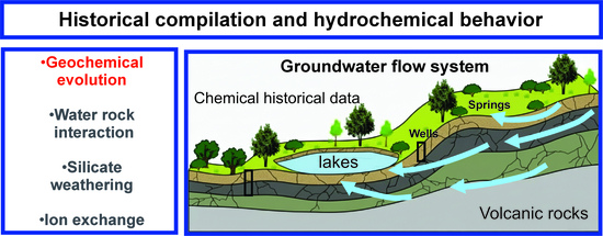
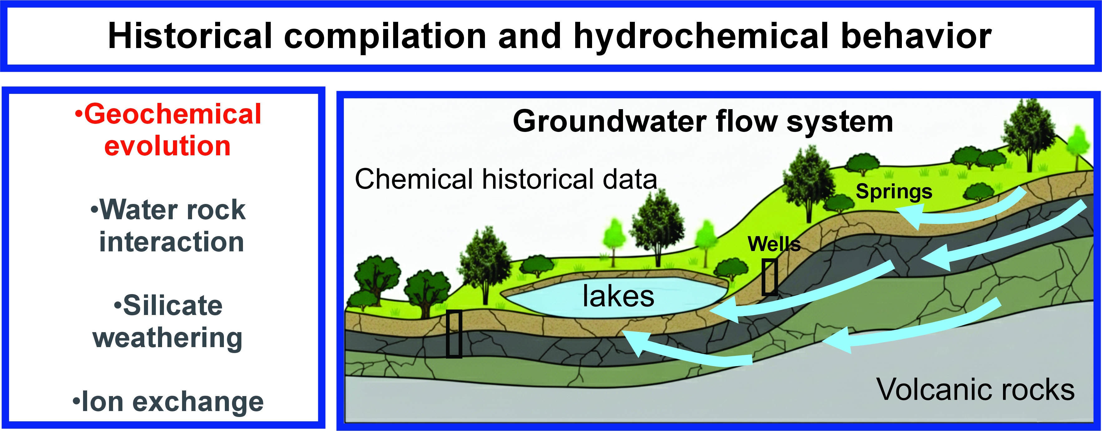
Graphical Abstract

1. Introduction

A groundwater flow system (GFS) is a distinctive groundwater system characterized by various flow paths or components, primarily driven by gravity, which respond to the physical, chemical, and climatological properties of the groundwater and the surrounding geology [1,2,3,4]. In Mexico, the GFS concept refers to a single hydrogeological system with a unified global base discharge level.
The base discharge level is the drainage level of an aquifer, representing the lowest groundwater level that occurs solely due to groundwater flow [5], it is essentially categorized into two types: (a) the global marine base-level, and (b) the continental, terminal, internal drainage system—also referred to as an endorheic base-level—that attracts and discharges convergent groundwater flow [6]. The GFS comprises a common recharge zone and connectivity between surface water bodies and the groundwater flow system [4].
Studying GFS provides valuable insights into its physical, chemical, and climatological behavior. Various approaches have been used worldwide to study GFS, including (a) isotopic analyses [7,8,9], (b) chemical and isotopic data [10,11,12], (c) geological environment data, e.g., well soundings [13], and (d) chemical data [14,15].
Hydrogeochemical studies of GFS enhance our understanding of groundwater behavior and its origins, particularly in relation to the rocks interacting within the flow path. Research on hydrogeochemistry in volcanic zones has been conducted in GFS settings such as in Ecuador [16], Japan [17], and Ethiopia [18,19,20]. In Mexico, however, the GFS have received limited attention despite their delimitation in 2018 by [4]. Nevertheless, several studies have examined the chemical behavior of groundwater and volcanic rocks (e.g., [21,22,23,24,25,26]). While these works provide extensive information on hydrogeochemical processes in volcanic rocks, they typically focus on the conceptualization of the aquifer or study area without addressing physical boundaries, recharge and discharge zones, or base levels of discharge, which are crucial for a more comprehensive understanding of groundwater hydrogeochemistry.
Few studies have investigated the behavior of GFS using hydrogeochemical data of groundwater that flows in volcanic rocks in Mexico, with notable works in Queretaro [27], Jalisco [28], Guanajuato [29], Zacatecas [30], Puebla [31], Michoacán [32,33], and Mexico City [34,35].
This study represents the first attempt to compile historical hydrochemical and groundwater level data for the Cuitzeo GFS to develop a spatial analysis, located in volcanic rocks spanning the states of Michoacán and part of Guanajuato, Mexico. Utilizing historical data to analyze the hydrochemistry and groundwater levels configuration of the GFS is a powerful approach for understanding chemical changes.
The main objectives of this research are to (i) compile historical data of the groundwater flow system to perform a spatial interpretation, (ii) investigate the groundwater levels configuration and hydrochemical behavior within the GFS, (iii) understand the water–rock interactions involving volcanic rocks.
This study investigates the spatial analysis and initial characterization based on historical data in the Cuitzeo GFS basin in central Mexico. The integration of existing data from different sources and years on the quality and availability of groundwater resources in the system, combined with the hydrogeochemical characterization and groundwater level developed in this study, will provide foundational insights into the water resources in the area. The key contribution of this study is that it provides hydrogeochemical information on groundwater flowing in volcanic systems and basic knowledge for sustainable groundwater resources management.

2. Materials and Methods

2.1. Study Area

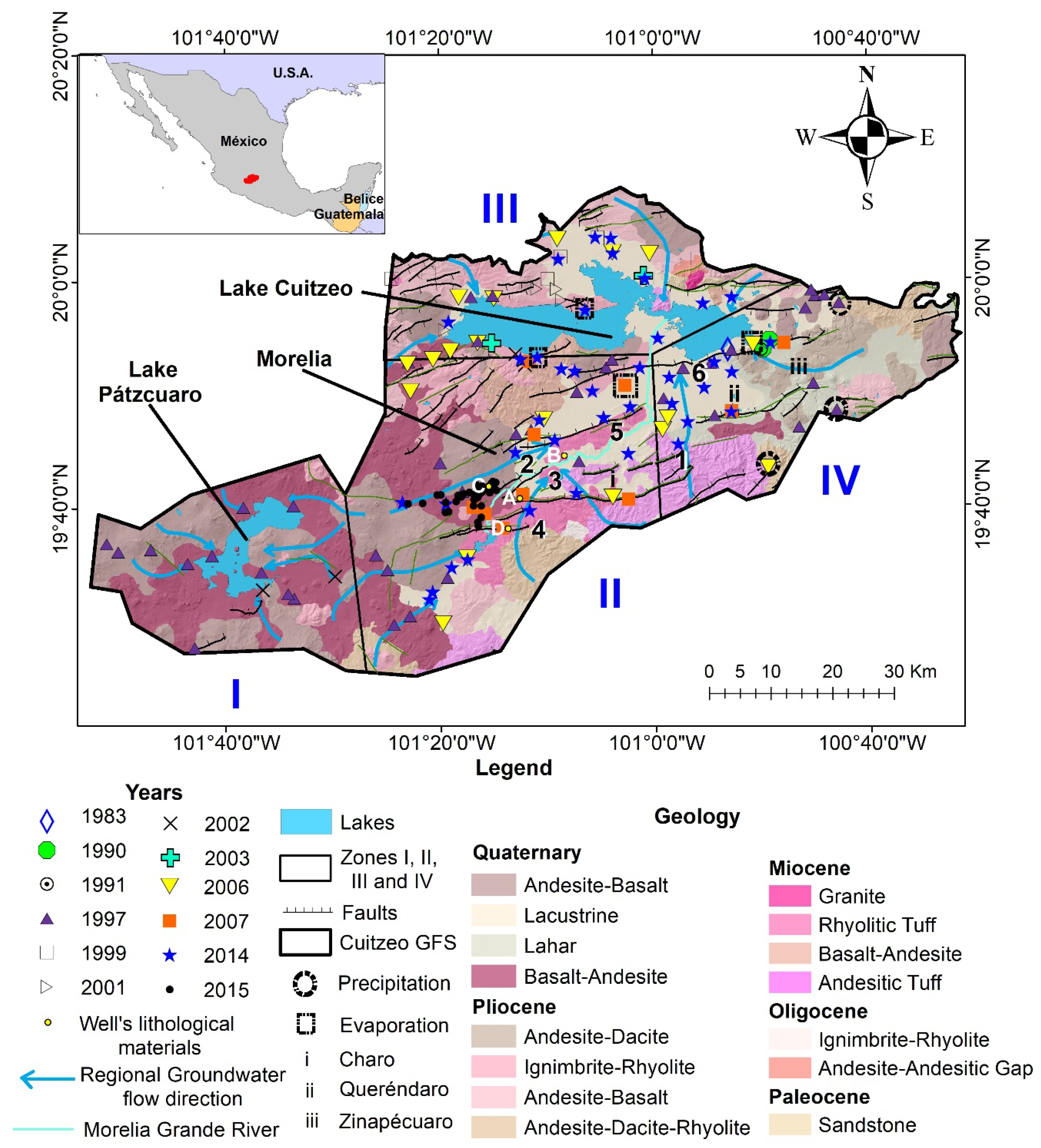
The Cuitzeo Flow System (Figure 1) is situated in the northwest of Michoacán and the southeast of Guanajuato states, central Mexico, covering an area of approximately 5208 km2. Its base discharge level is associated with a freshwater inland lake [4]. The study area includes two of Mexico’s largest lakes, Lake Cuitzeo and Lake Pátzcuaro, which are the second and third largest, respectively [36].
Lake Cuitzeo, formed during the Miocene–Holocene period [37], is located in a region with a temperate climate that transitions between dry and humid temperate zones. The lake experiences an average annual temperature of 17.3 °C and an average annual precipitation of 841 mm [38]. In contrast, Lake Pátzcuaro, formed during the Cenozoic–Quaternary period [39], has a sub-humid temperate climate, with average annual temperatures ranging from 14 to 17 °C and average annual precipitation of around 1000 mm [38].
Within the Cuitzeo GFS, there are 1573 registered groundwater concessions, which represent permits granted by Mexican government agencies for water extraction. These concessions are used for various purposes: agriculture (919 permits), public urban use (397 permits), services (101 permits), industrial activities (83), domestic consumption (31 permits), livestock (26 permits), multiple uses (9 permits), aquaculture (5 permits), and agro-industrial purposes (2 permits) [40].
To understand the hydrochemical behavior of the study area, it was divided into four Zones based on the regional groundwater flow network [4], which identifies recharge zones and flow directions towards the lakes (Figure 1). Zone I encompasses all groundwater contributions to Lake Pátzcuaro in the western region. Zone II, situated in the central region, includes the city of Morelia and groundwater inputs to the Grande de Morelia River. Zone III, located in the northern part of the system, involves the flow from north to south towards Lake Cuitzeo, while Zone IV includes the flow from the southeast to Lake Cuitzeo (Figure 1).
The groundwater depths in the GFS Cuitzeo present different values taken from the literature: in Zone I, in the vicinity of Lake Pátzcuaro from 1 to 4 m, to the east from 80 to 115 m, to the northeast of 120 m [41]; in Zone II, in Morelia from 50 to 160 m, and lowering groundwater level from 20 to 40 m [42]. In Zone III and IV, the phreatic levels show significant variations. Specifically, in the vicinity of Lake Cuitzeo, depths range from 3 to 10 m, while northward they reach depths of 100 to 120 m, and in the northeastern region depths of 200 to 220 m are observed [43].

2.2. Geology

The geology of the Cuitzeo GFS is predominantly composed of volcanic rocks (Figure 1).
Zone I: The El Estribo Volcanic Complex is located beneath Lake Pátzcuaro. It consists of several light-gray breccia units interlayered with lava flows at the base. These rocks are Pleistocene andesites [44].
Zone II: The units are from Miocene age. The Quinceo-Tetillas Volcanic Complex, situated on the southern shore of Lake Cuitzeo, is composed of volcanic materials including pumice sequences, lava flows of basaltic and andesitic-basaltic composition, and fissure breccia. The outcrops are deformed, hydrothermally altered, and tilted [45]. The Sierra de Mil Cumbres Volcanic Complex, located near Morelia, comprises ignimbrites, lava domes, lava flows, and cinder cones, with a thickness of 800 m [46,47]. The Punhuato Volcanic Complex, in the eastern part of Morelia, is characterized by intercalations of lava flows of andesitic and dacitic composition and breccia associated with domes [47]. The La Escalera Ignimbrites are located south of Charo municipality (i in Figure 1) and date to the Miocene [46]. Debris flow and debris avalanche deposits are also present in the southern part of Charo municipality, consisting of massive, hydrothermally altered materials with andesitic and dacitic compositions [46].
Zones III and IV: The fluvio-lacustrine sediments of Cuitzeo, located along the southern edge of Lake Cuitzeo and the paleolake of Cuitzeo (between the municipality of Queréndaro (ii in Figure 1)), consist of epiclastic fluvio-lacustrine sediments, including clays, siltstones, sandstones, conglomerates, diatomites, pumice, obsidian, and basaltic-andesitic fragments. These deposits are approximately 40 m thick and date to the Pliocene [48]. The Garnica Volcanic Complex, at the eastern edge of the Sierra de Mil Cumbres (south of Queréndaro municipality), includes deposits of lava andesitic, ignimbrites, and domes with compositions ranging from andesite to rhyolite, from the Miocene [48]. The Indaparapeo Volcanic Complex, located northeast of La Escalera (to the east of Queréndaro municipality), features basaltic-andesite to dacitic units from the Pliocene–Miocene [46]. The Los Azufres Volcanic Complex, located between Queréndaro and southern Zinapécuaro municipality (iii in Figure 1), is characterized by fluvial-lacustrine sediments covered by rhyolitic domes and associated pyroclastic deposits, dating to the Pleistocene [48]. Pyroclastic deposits located south of Zinapécuaro municipality are composed of pumice, ash, rhyolitic, and basaltic-andesitic protoliths, along with a massive ash and pumice flow deposit, less than 100 m thick [48]. The Rhyolitic Tuff is distributed along the southern margin of Lake Cuitzeo (northwest of Zinapécuaro municipality) and dates from the Upper Tertiary to Quaternary [49]. The Alluvial Unit, found on the slopes of prominences and in volcanic structures, consists of gravel and sand-sized fragments of various compositions. The fragments range from subrounded to rounded, lack cement and contribute to the unit’s high permeability, and date to the Pleistocene [49]. The Basaltic Unit and Basaltic Volcanic Breccia, located in the Morelia region along the southern edge of Lake Cuitzeo (west of Zinapécuaro municipality), are of Holocene age [49]. The Lacustrine Unit extends widely to the south and east of Zinapécuaro municipality and consists of fine sands, silts, and clays deposited in a shallow lagoon environment, dating to the Quaternary [49].
Finally, distributed across all four Zones, the Michoacán-Guanajuato Volcanic Complex represents the central portion of the Trans-Mexican Volcanic Belt (TMVB). This complex consists of over 1000 monogenetic eruptive centers, predominantly andesitic in composition, though the spectrum ranges from alkaline basalts to rhyolites, dating to the Quaternary [50,51]. Zones II, III, and IV have wide distribution of faults, whereas Zone I is poorly in faults presence, the faults in all the Zones are normal [52,53,54].
The Morelia-Acambay Fault System (MAFS), a ~30 km-wide zone, includes E-W to ENE-WSW sinistral strike-slip faults forming the tectonic depressions of Cuitzeo and Morelia [55,56]. Around 12 million years ago, the stress regime shifted, reactivating these faults as normal listric faults with minor sinistral strike-slip components. These extensional faults, still active today [37,57], are the transfer faults within the MAFS, aligning with a NNW-oriented minimum principal stress [58]. NE- and ENE-trending faults also control deep-seated geothermal systems [59].
Key normal faults include La Paloma, which spans 15 km in length and ranges between 1 and 4 km in width, while the Central Morelia fault Zone extends 16 km in length and 2 to 6 km in width, with La Colina identified as an associated fault. Similarly, the Cointzio fault Zone measures 15 km in length and 6 to 8 km in width. The Tarímbaro-Álvaro Obregón fault Zone is the largest, with a length of 40 km and a width of 5 to 6 km. Finally, the Zinapécuaro fault Zone spans 20 km in length and 3 to 6 km in width [37] (Figure 1).

2.3. Historical Data

An extensive compilation of historical data for the study area was carried out using public sources such as Mexico’s National Institute of Statistics and Geography (INEGI), the National Water Commission (CONAGUA), the Mexican Institute of Water Technology (IMTA), as well as theses, research papers, and technical reports.
The compiled data of water levels, deep levels, and hydrogeochemical data come from locations and different dates; they represent regional information of the study area. This study provides the first knowledge of the Cuitzeo GFS in a regional sense because the data has a good spatial distribution.
Groundwater levels data were compiled from the years of 2001 (with 61 sites) and 2007 (with 350 sites) from CONAGUA [60,61] in Zones II, III, and IV. The groundwater levels of Zone I have never been reported previously and cannot be compiled by this study.
The depth of pumping is not possible to define because the wells are traditionally designed to maximize water extraction; consequently, slotted casings often extend through all water-bearing sections, making it impossible to define a specific collection depth.
The depth of wells was compiled from CONAGUA [61] with 134 values in the N of lake Cuitzeo (Zone III) and 8 wells in Zone II close to Morelia (Figure 1) along with unpublished data from the Morelia drinking water operating agency. Additionally, 4 lithological columns were compiled to determine the lithological materials in the subsoil (Figure 1 marked as A, B, C and D) from the drinking water operating agency. This shows that in the area there is no database that integrates information on the wells and their lithological columns, which makes this compilation very important. Consequently, it is not possible to directly determine subsurface materials; instead, we rely on geological mapping from the Mexican Geological Service [54,62] to infer subsurface geology.
The hydrochemical historical data spans the years 1983, 1990, 1997, 1999, 2001, 2002, 2003, 2006, 2007, 2014, and 2015, covering a total of 170 sites. The data set is composed of 33 springs, 89 wells, 3 dug wells, and 45 unknown type sites. Zone I: 6 springs, 6 wells, and 2 dug wells; Zone II: 13 springs, 54 wells, and 20 unknown type; Zone III: 1 spring, 18 wells, and 16 unknown type sites; Zone IV: 13 springs, 11 wells, 1 dug well, and 9 unknown type.
Hydrogeochemical data were obtained from various sources: Data from 1983, 1990, 2001, 2002, and 2015 were extracted from research papers [32,33,63,64,65]; 1997 and 2014 data came from the Hydrological Map at a 1:250,000 scale by INEGI [66]; data from 2006 were derived from a master’s thesis [67]; and 2007 data was taken from CONAGUA-IMTA aquifer update reports [41,42,43].
The compiled parameters include temperature (°C), pH, total dissolved solids (TDS), and major ions (Ca2+, Mg2+, Na+, K+, SO42−, Cl, HCO3, CO32−, and NO3). The TDS values missing in the compilation for samples 29–31, 112–120, and 137–141 were calculated using the major ions values in mg/L.
Prior to using the compiled data and considering the heterogeneity of sources, we validate the data used with the application of charge balance error (CBE) equation (Equation (1)), with values considered acceptable if within a ±10% error limit [68,69]. The samples outside of this error were excluded from the analysis.
CBE% = (∑ Cations)mEq/L − (∑ Anions)mEq/L)/(∑ Cations)mEq/L + (∑ Anions)mEq/L)
It is important to note that the results presented in this study are based on hydrogeochemical data collected over an extended period (1983–2015); therefore, our objective is to provide a first approximation of the spatial distribution of groundwater chemistry using all available historical information, rather than to evaluate its temporal evolution. Because the data are limited and spatially dispersed, it is not possible to directly compare different years or assess long-term geochemical changes, so this approach should be viewed as an initial framework that future studies with more recent and consistent datasets could refine to analyze temporal trends. Despite these limitations, this study is particularly significant as it represents a foundational step toward understanding the Cuitzeo GFS in the region. The compilation of historical water levels and hydrochemical data not only provides an initial framework for analyzing groundwater behavior but also highlights critical gaps in knowledge, serving as a guide for future research. By identifying areas of opportunity, this work lays the groundwork for more detailed investigations into the region’s groundwater dynamics.

2.4. Hydrochemical and Groundwater Level Analysis

The hydrochemical characteristics and factors controlling the groundwater geochemistry of the 170 hydrochemical samples in the GFS were analyzed using the following tools.
We employed the Piper trilinear diagram [70] to depict the variations in groundwater chemistry across the four zones; it facilitates the evaluation of groundwater characteristics by simplifying the estimation of the proportions of key cations (Ca2+, Mg2+, Na+, and K+) and anions (Cl, SO42−, and HCO3). This diagram allows us to evaluate the hydrochemical evolution of groundwater in the GFS.
We used the Gibbs plot to identify the dominant hydrogeochemical processes—precipitation, water–rock interaction, and evaporation—affecting groundwater chemistry [71]. Gibbs diagrams are widely utilized to investigate chemical components’ origins in water and analyze the mechanisms underlying water chemistry formation [72,73]. Additionally, a Gibbs-adapted diagram specifically designed for groundwater [74] was employed to elucidate the primary factors influencing groundwater chemistry: salinization; refreshing; brine; geochemical evolution; and water–rock interaction, particularly with carbonates or silicates, and rainwater. This diagram is crucial for outlining and understanding the complex interactions between groundwater and the surrounding geological formations [74] within the study area.
The relationships between major ions in scatter plots and bivariate diagrams are valuable tools for interpreting geochemical processes involved in water–rock interactions during groundwater circulation [75]. Similarly, ionic ratios, which represent the proportions between major ions and/or trace elements, are widely employed to identify sources of salinity [76]. Therefore, both bivariate plots were used to understand the geochemical processes in groundwater. Additionally, a plot of Na/Ca was used to understand the silicate weathering relations in the compiled samples as a source of chemical composition such as calcium silicate weathering or sodium silicate weathering.
In order to understand the changes in the groundwater direction, the Kriging method [77,78] was using with surfer version 13, for the years 2001 and 2007. This method was used to develop the spatial interpolation of groundwater elevation. The general movement of groundwater was considered perpendicular to the isolines of groundwater elevation [79].
Figure 1. Study area of the Cuitzeo GFS, showing the division into study Zones, the locations of compiled sampling points, and the groundwater flow directions (adapted from [4]). The geological data is based on information from the Mexican Geological Service [54,62]. Names of faults: (1) La Paloma, (2) La Colina, (3) Central Camionera, (4) Coíntzio, (5) Tarímbaro, (6) Zinapécuaro. Wells’ lithological materials (A, B, C and D) can be seen in Table S9 of the Supplementary Materials. Sampling sites where precipitation and evaporation processes dominate, according to the Gibbs diagram, are marked with black circles and dotted lines. All other unmarked sites represent water–rock interaction processes.
Water 18 00171 g001

3. Results

The descriptive statistics of the compiled hydrochemical data are presented in Table 1, while the complete hydrochemical dataset can be found in Tables S1–S4 of the Supplementary Materials: Zone I has 14 data points, Zone II has 87 data points, Zone III has 35 data points, and Zone IV has 34 data points.
The maximum values in Zones I, II, and III are in HCO3 and TDS, whereas in Zone IV, it is K+ and TDS. The minimum value in Zone I, II, and III is Cl. On the contrary, in Zone IV it is HCO3. The highest value of standard deviation in Zone I is HCO3, whereas in Zones II, III, and IV are TDS (Table 1).
The groundwater levels can be seen in Tables S5 and S7 of the Supplementary Materials, with 61 data points for 2001 and 411 data points for 2007, whereas groundwater depths are presented in Tables S7 and S8 of Supplementary Materials, with 8 data points in Zone II and 134 data points in Zone III. In Zone III, 14 sites are shallow (13–40 m), 98 are intermediate depth (40–100 m), and 22 are deeper (100–250 m). Zone II is the deepest with 8 data points (91–300 m).
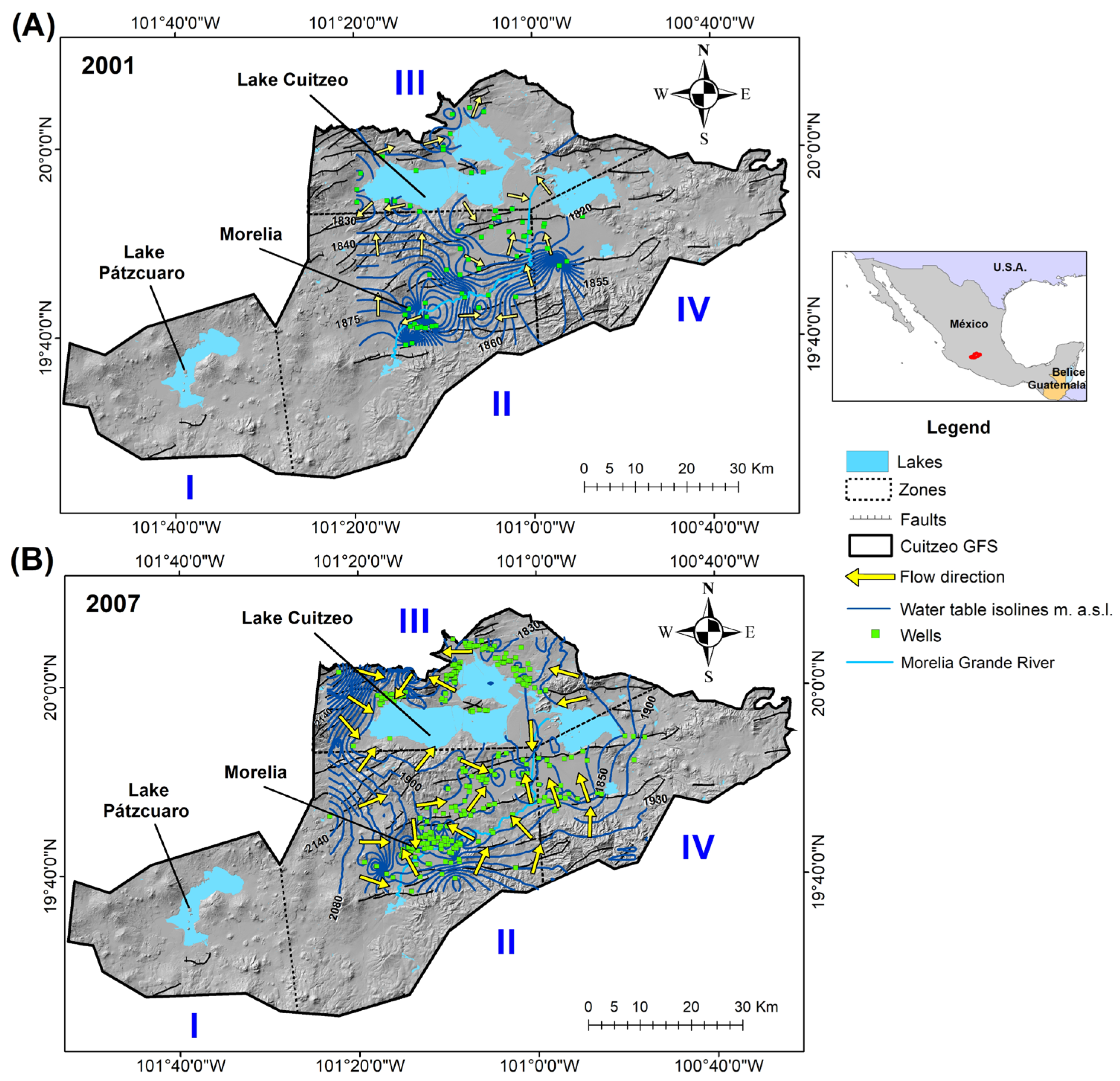
The groundwater levels maps for the years 2001 (Figure 2A) and 2007 (Figure 2B) show the preferential flow directions in Zones II, III, and IV. In the south of Lake Cuitzeo, groundwater flow patterns were similar in 2001 and 2007, flowing toward the faults. In contrast, in the northwest of Lake Cuitzeo, groundwater flow changed between the two periods: in 2001, water flowed away from the lake, whereas in 2007, water flowed toward the lake. The groundwater elevation values can be found in Tables S5 and S6 of Supplementary Materials.
Water is primarily extracted from wells less than 100 m deep, although some deeper wells reach up to 300 m. The deepest wells are located in Zone II, within the city of Morelia. Detailed information can be found in Tables S7 and S8 of the Supplementary Materials.
The lithological columns from the four wells compiled in the Morelia area (Zone II) predominantly consist of basaltic and andesitic rocks. The thickness of these lithological materials is presented in Table S9 of Supplementary Material and the locations are shown in Figure 1.
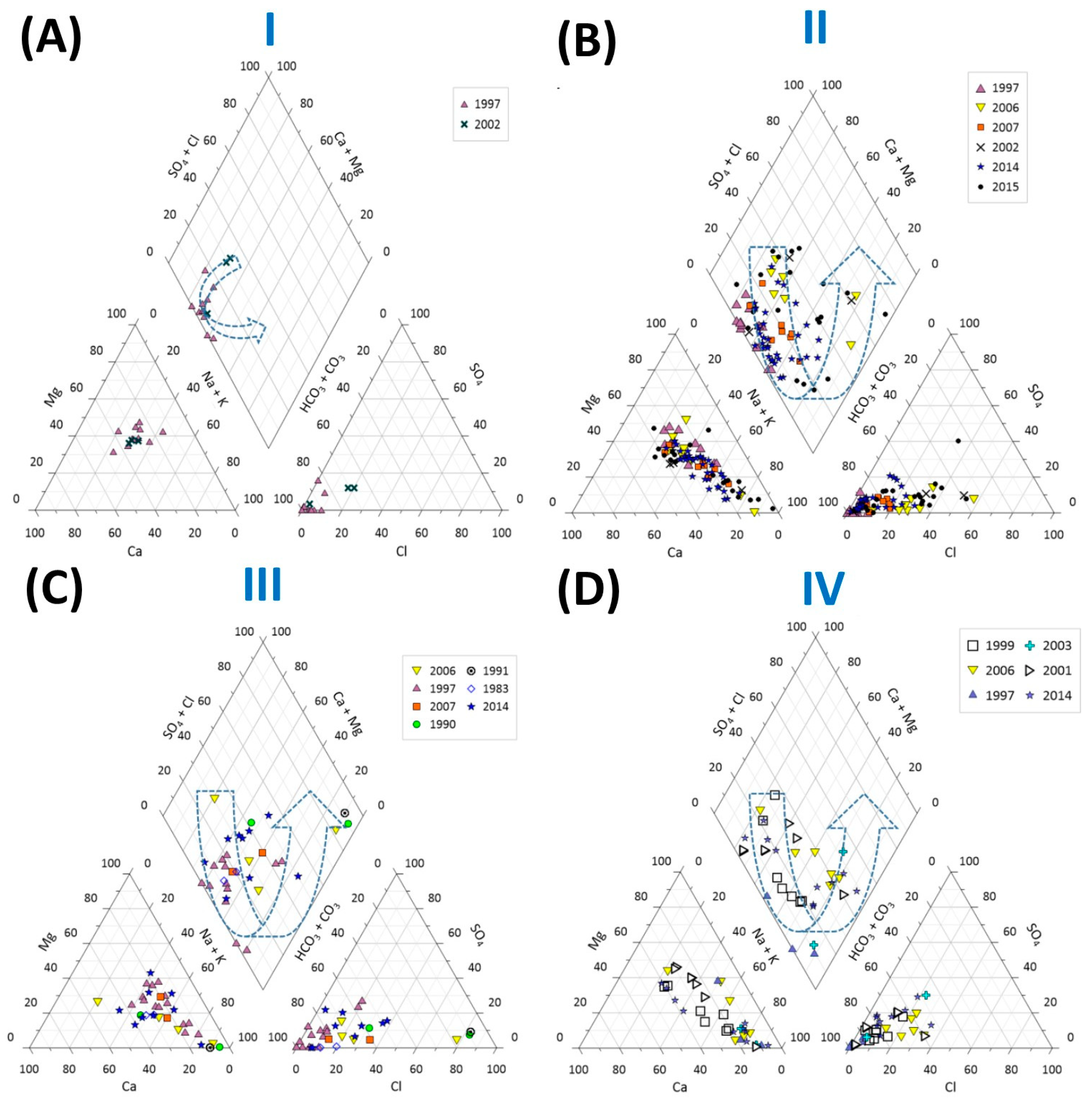
The Piper diagram for the compiled data from the Cuitzeo GFS shows that in Zone I, groundwater is predominantly of the magnesium bicarbonate type. In contrast, Zones II, III, and IV exhibit a transition from magnesium bicarbonate type to sodium bicarbonate type, and to sodium chloride type, with the highest chloride concentrations observed in Zone IV (Figure 3).
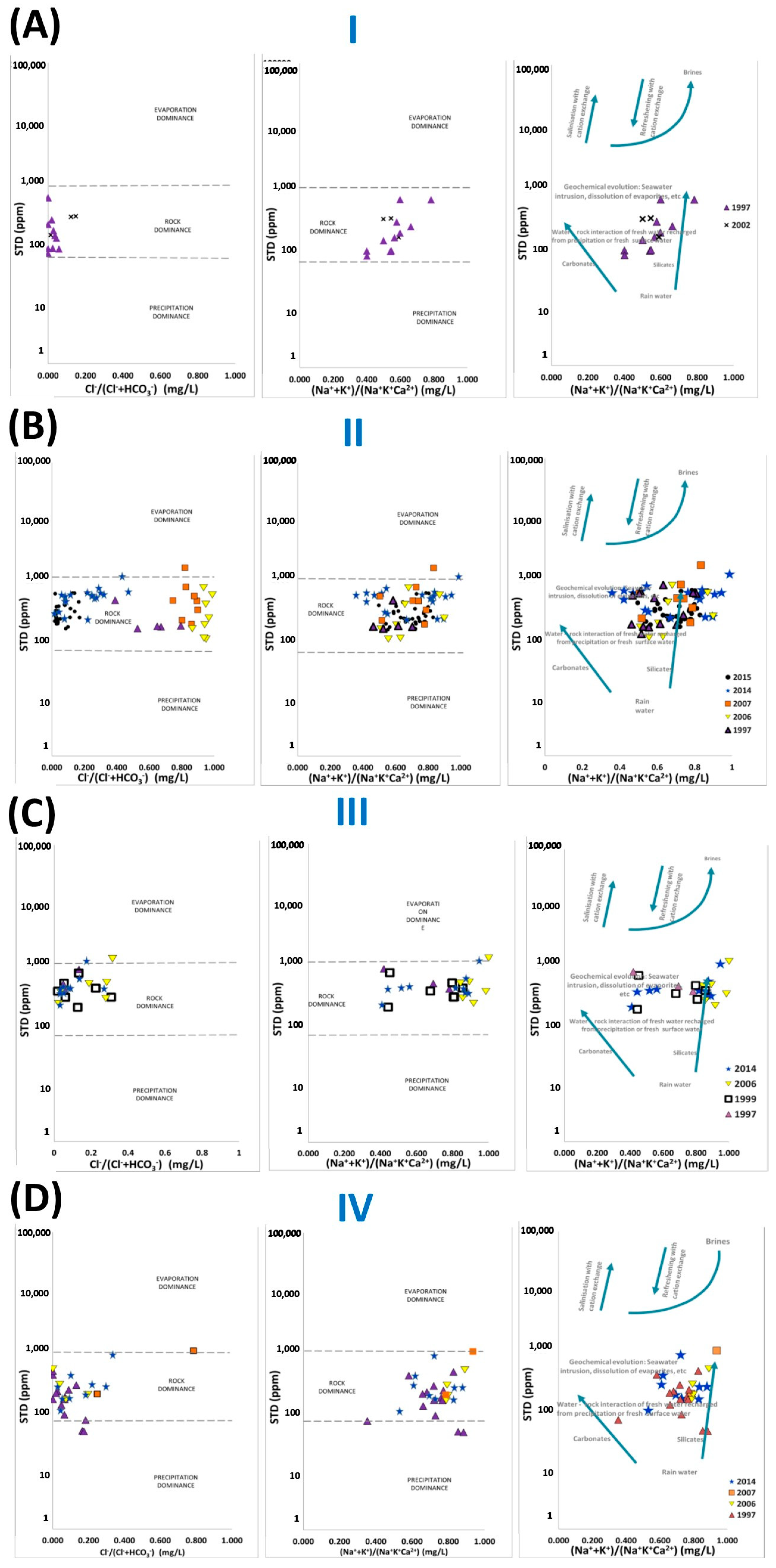
The Gibbs diagrams of the compiled data show that the dominant process across all four Zones is water–rock interaction (Figure 4). However, a few points in Zones II, III, and IV fall within the evaporation field (according to the Gibbs diagram). The precipitation data are only present in Zone IV. Additionally, the data indicate that groundwater in all Zones is mainly associated with silicate weathering and water–rock interaction with fresh water interaction (Figure 4D).
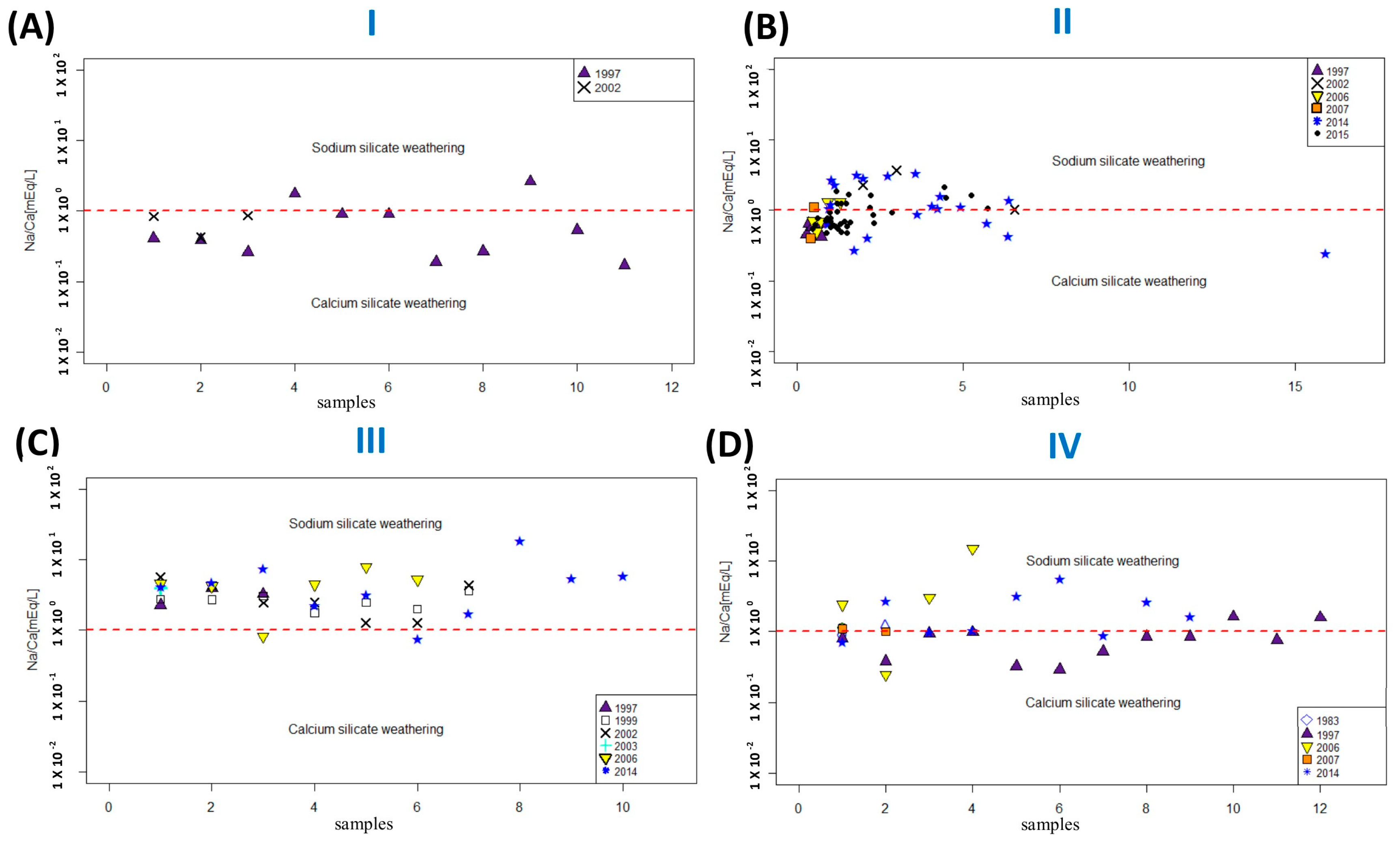
The silicate weathering diagram displays mainly weathering with both sodium and calcium silicates. In Zone I, the dissolution of calcium silicates predominates over sodium silicates, whereas in Zone III, the dissolution of sodium silicate predominates over calcium silicates, with only two samples in the calcium silicate field (Figure 5).
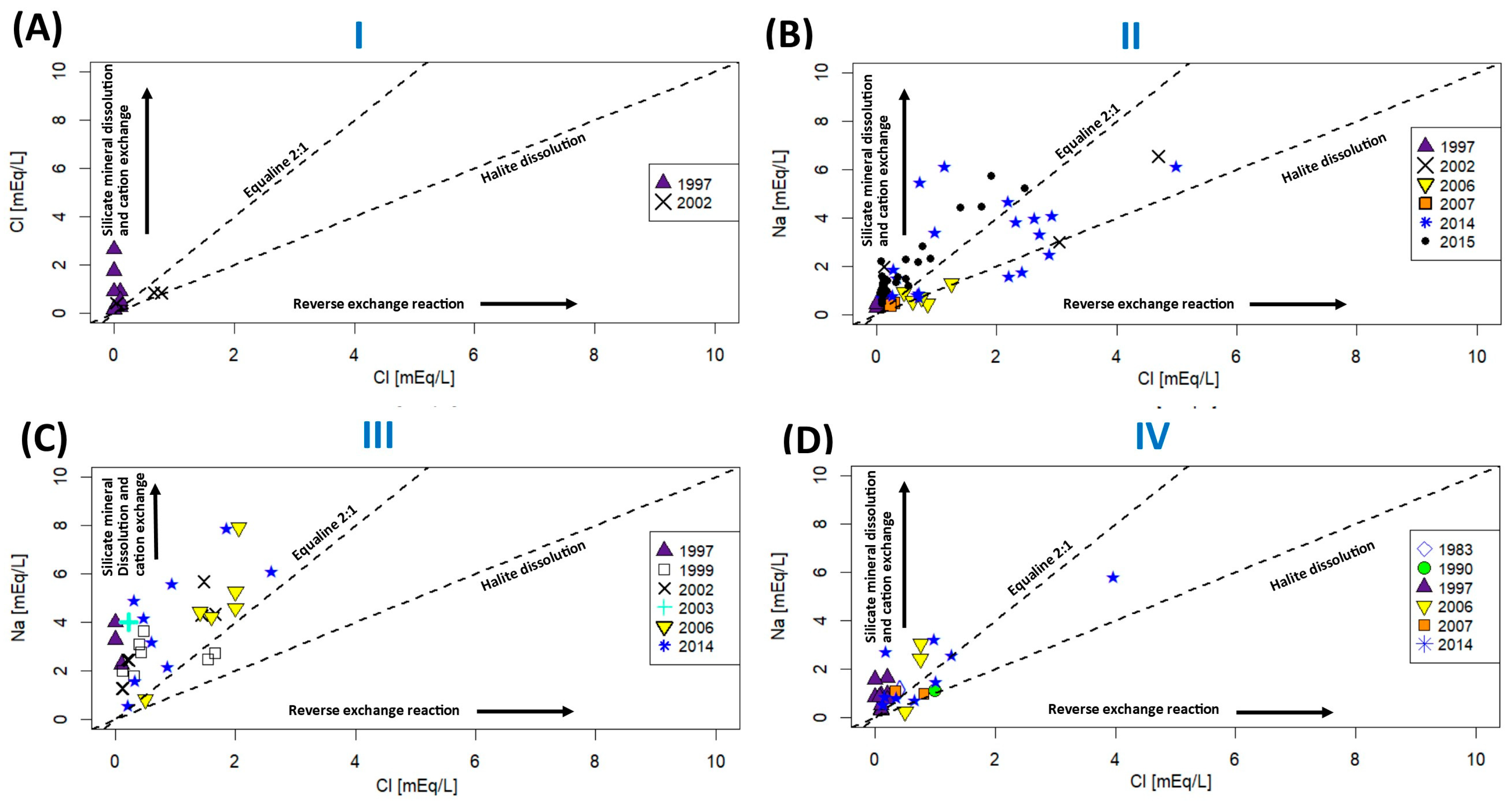
The bivariate plot of Cl vs. Na+ suggests that the predominant processes in the Cuitzeo GFS are the silicate mineral dilution and cation exchange. An exception occurs in Zone II, where some samples plot within the halite dilution and reverse ion exchange fields, although the majority still plot in the ion exchange field. Additionally, Zone IV exhibits lower Na+ values compared to Zones II and III (Figure 6).
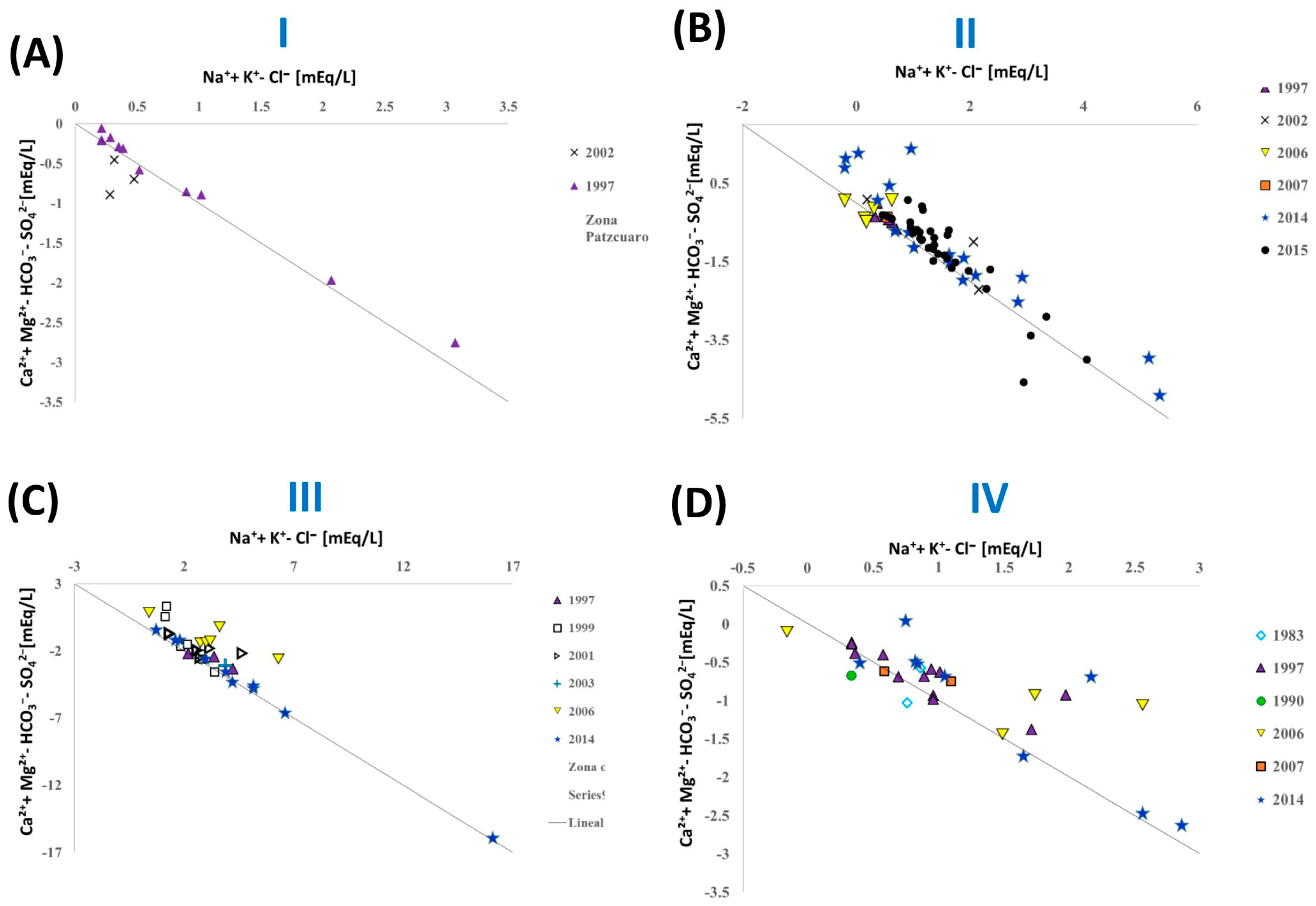
The data points plotted along the line indicate ionic exchange, with the 1997 data from all zones fitting well to the regression line. Zone I is more closely aligned with the regression line in 1997 (Figure 7A), while Zones II and III (Figure 7B,C) also display data that are closely aligned with the regression line.

4. Discussion

4.1. Dynamics of Subsurface Flow Systems

The regional groundwater flow direction, as outlined by [4], explains the evolution of groundwater from recharge areas in the west and east to more chemically evolved compositions in Zones II and III. Temporal variations in flow direction suggest that extraction rates have altered the preferential flow paths to or from Lake Cuitzeo. Groundwater flows from recharge to discharge areas, ultimately discharging near Lake Cuitzeo.
The compiled data on well depths indicate that water is extracted from depths ranging between 15 and 300 m; these are different for Zones, the deepest being Zone II. In Zone II, groundwater depth variability is influenced by pumping rates (Figure 2). The spatial variability in flow directions is particularly notable in geologically contrasting areas. For example, fault zones exhibit flow directions from the north and south, likely influenced by structural controls on groundwater movement. In contrast, the Morelia area, characterized by higher water extraction rates and the deepest wells in the system (Figure 2), presents the highest well density, with convergent groundwater flow direction, a pattern more pronounced in 2007. Unfortunately, the lack of detailed groundwater level data, including well depths in Morelia, prevents a comprehensive assessment of the relationship between deeper well extractions and alterations to flow direction.
Another notable limitation is the absence of groundwater level data in Zone I, which restricts the complete evaluation of the groundwater system (GFS) dynamics in this area. Nevertheless, understanding the depth and flow of the groundwater levels in other parts of the GFS provides critical insights. The restricted availability of data not only complicates the evaluation of the groundwater levels configuration but also highlights the urgent need for systematic data collection. Such efforts would significantly enhance our knowledge of the system’s behavior, particularly in understudied regions like Zone I. Therefore, this study is crucial for highlighting the lack of existing data.
In 2001, the groundwater flow direction was from the north and south toward the River Grande de Morelia. However, by 2007, the flow was observed only from the south toward the river. Despite the river containing residual waters, its hydrological connectivity with the groundwater has not been studied. Nonetheless, groundwater depths exceeding 15 m suggest that the river and groundwater are likely not hydraulically connected. In 2001 and 2007, the groundwater direction suggests groundwater inputs to the Lake Cuitzeo, with some convergent flows in the central zone in the boundary between Zones II, III, and IV, indicating a complex interaction likely influenced by structural controls.

4.2. Chemical Characteristics of Groundwater

The hydrochemical parameters of groundwater reflect an increase in mineralization of zones from Zone I, II, III, and IV (Table 1). Zone I presents the lowest values of TDS and major ions; whereas Zone II shows increased TDS, temperature, sodium and nitrate; while Zone III displays elevated TDS, nitrate, Na, Ca, and Mg; and Zone IV exhibits elevated TDS, temperature, nitrate, and Cl content. The nitrate behavior in the four zones cannot be evaluated because Zone I lacks recent hydrochemical data. It is recommended that future studies evaluate the nitrate values in Zone I. Nevertheless, the Pátzcuaro–Cuitzeo region is among the most agriculturally developed areas of west-central Mexico [80]. The increases in nitrate values in Zones II, III, and IV could be associated with agricultural activities, in Zone II [81], and in Zones III and IV with the irrigated crops across the Lake Cuitzeo basin [82,83].
In the Piper diagram analysis (Figure 3), groundwater from Zone I is classified as magnesium bicarbonate type, consistent with previous findings by [41]. In Zones II, III, and IV, the water transitions from bicarbonate type to mixed water, and ultimately, to sodium/chloride types. The mixing waters could result because the slotted casings extend through all water-bearing sections.
This evolution is particularly evident in Zone IV (Figure 3), where more chemically evolved samples were identified. The observed patterns in the compiled data are consistent with the conceptual model proposed for Zone II using data from 2015 [84], which describes groundwater evolution as progressing from recharge areas with bicarbonate-rich water to chloride-enriched waters in discharge Zones.
According to the Gibbs diagram (Figure 4), groundwater in the study area evolves through interactions with volcanic and silicate rocks, as well as lacustrine deposits. These interactions result in an increase in the concentrations of Na+, K+, Mg2+, and Cl and are consistent with those reported by [84]. Sites located in evaporation zones, particularly in Zones II, III, and IV near Lake Cuitzeo (Figure 4B–D), show a strong correlation with faulting and the proximity to lacustrine environments [55,56]. Conversely, sites within precipitation in Zone IV may represent areas of recent groundwater recharge, located in the high elevation at the boundary of Cuitzeo GFS (Figure 1). The observed evaporation processes near Lake Cuitzeo could be explained by two mechanisms: (1) groundwater evaporation at shallow depths near discharge zones, as proposed by [74], or (2) salinization/mineralization through a regional flow path, which would allow more time for ion dissolution and salinity increase. These processes are less pronounced in areas where the groundwater levels occur at greater depths, aligning with observations by [74,85]. If these points correspond to discharge zones, both mechanisms may be contributing. Future isotopic sampling is essential to understand the evaporation processes occurring in the study area.
Zone II presents a grouping behavior associated with the chloride content, suggesting a different process in this zone that has deeper wells and groundwater levels including (a) different chloride sources: from natural rock–water interaction, evaporation, or anthropogenic inputs; (b) distinct flow systems, if wells tap different components (e.g., local or regional; and (c) temporal variations, where changes in recharge or pumping can alter Cl concentration independently of lithological control.

4.3. Hydrogeochemical Processes

Sodium and calcium silicate weathering constitute the main source of these elements in the groundwater (Figure 5); however, ion exchange processes play a pivotal role in the hydrogeochemical evolution of groundwater in the region (Figure 6 and Figure 7).
The ion exchange process is evident in Zone I (Figure 6), where 2002 samples align close to the 1:1 equality line, indicating that the sodium originates primarily from halite dissolution. However, samples from 1997 and samples in sectors II, III, and IV deviate significantly above this line, showing an excess of sodium that cannot be explained solely by halite dissolution. This excess of sodium, without a proportional increase in chlorine, indicates cation exchange: dissolved calcium and magnesium are replaced by sodium adsorbed on rock minerals. This behavior is confirmed by Figure 7, where the excess sodium increases (horizontal axis), and calcium and magnesium decrease proportionally (vertical axis), which is exactly what is expected in ion exchange. In summary, the progressive displacement of the samples from Zone I to Zones II–IV (Figure 6 and Figure 7) demonstrates that cation exchange is an important process in the evolution of groundwater composition as it flows in the rock medium.
The Na+/K+ is released directly from mineral weathering and Na+ enrichment due to cation exchange. The materials such as sedimentary and lacustrine deposits, and silicates from volcanic rocks (Figure 1), could be the source for cation exchange. The weathering of silicate rocks forms clays rich in aluminosilicates, allowing the adsorption and exchange of cations [69]. High salinity and elevated pH values further enhance this process. For instance, a 2014 groundwater sample from the southwestern region of Lake Cuitzeo, classified as sodium sulfate water, demonstrates the influence of ion exchange in the system (Figure 3B). The positive CBE values for all the samples suggest a possible release of Na+/K+ by cation exchange (Tables S1–S4 of Supplementary Materials). Sodium and potassium in these processes are primarily derived from volcanic rocks containing sodium plagioclase, alkali feldspars, and biotite [86]. Additionally, sedimentary rocks, including lacustrine deposits, contribute significantly to these exchange processes [87]. Lacustrine deposits are located in the vicinity of lakes Cuitzeo and Pátzcuaro.

4.4. Conceptual Model

The overall behavior of the Cuitzeo GFS indicates that groundwater recharge primarily occurs in Zones I (western) and IV (eastern), where it flows through volcanic rocks (Figure 1 and Figure 2), dissolving silicate minerals—mainly from ignimbrites, basalts, and andesites—resulting in increased chemical concentrations. In Zone IV, ignimbrites are present, containing minerals such as plagioclase, olivine, pyroxene, amphibole, biotite, K-feldspar, and volcanic glass [88]. Additionally, basaltic lavas from the Araro–Simario complex occur in this zone, composed of plagioclase, olivine, and pyroxene [48].
Pronounced ion exchange processes are observed in Zones I, II, and III (Figure 6 and Figure 7). This pattern indicates a continental endorheic base level [4], where groundwater evolution may be related to the lake’s salinity. This process is likely linked to the lake’s declining water levels and increasing salinity, a phenomenon documented for the past 3000 years [89]. This natural groundwater evolution reinforces the role of Lake Cuitzeo as a continental endorheic base level, isolated from marine influences [6].
The faults and geology could control other parameters such as temperature. In Zone IV temperatures reaching 111 °C have been reported. Similarly, geothermal sites with temperatures around 70 °C occur in the same zone [90]. To better understand the source of the high temperatures, a sampling campaign should be conducted that includes the determination of physicochemical parameters, major anions, trace elements, and stable isotopes δ18O and δ2H. This would allow evaluation of potential geothermal influence on groundwater temperatures.
Data availability of Zones II, III, and IV provide information on changes in the flow direction and dynamics of Cuitzeo GFS.; these might be used to understand Zone I, where the data availability is limited. Nevertheless, the compilation and analysis of data from all zones provide critical insights into the flow and chemical processes within the GFS, offering a robust framework for understanding its behavior.

5. Conclusions

This research is the first effort to compile and spatially map historical groundwater data for the Cuitzeo GFS, integrating information from 170 sampling sites and hydrogeochemical data from 11 years, supplemented by water levels from 2001 and 2007, and well depths and lithological information from multiple sources. Although the inherent limitations of temporally dispersed and spatially heterogeneous (unequally distributed across zones) data, this compilation provides the first regional framework for characterizing the system’s behavior. This integration of data from multiple sources establishes a methodological precedent for the characterization of complex aquifer systems in Mexican volcanic environments.
The groundwater direction in the Cuitzeo GFS reveals that the dynamics are controlled by extraction rates, evidenced by significant changes in the preferential flow direction between 2001 and 2007. That is, in Zone II, a hydraulic gradient reversal is observed in 2001, flow originated from the north and south toward the Río Grande de Morelia, whereas in 2007, flow came from the south. These changes could indicate a pumping increase. In Zone IV, flow is in the direction of the faults; it demonstrates that geological structures maintain control over flow pathways. The reorganization of flow patterns in just 6 years points to the system vulnerability to accelerated anthropogenic pressures and the urgency of systematic post-2007 monitoring to assess the trends.
The hydrochemical behavior in the Cuitzeo GFS is controlled by silicate weathering and ion exchange as the primary mechanisms of geochemical evolution. Silicate weathering dominated all the zones, being the main source of Na+, K+, Ca2+, and Mg2+ that are released from volcanic minerals. Ion exchange is a secondary process, where the progression from magnesium bicarbonate water type (Zone I) to sodium chloride water type (Zone IV) reflects an increase in residence time and consequently a prolonged interaction with lacustrine deposits and volcanic silicates. This geochemical characterization confirms that Cuitzeo Lake is the discharge zone of a continental endorheic system.
The chemical variations observed in the Piper diagram across the four Zones indicate the natural evolution of groundwater within the flow system. Zone I is characterized by bicarbonate-type waters, while Zones II, III, and IV show a transition toward bicarbonate-sodium and sodium chloride types. The compiled data reflect bicarbonate waters in the recharge Zones and sodium-chloride waters in the discharge Zone located in the vicinity of Lake Cuitzeo.
In base of the groundwater directions, the evolution of groundwater in the system suggests a natural process, with recharge occurring in the western and eastern Zones and discharge taking place near the center, in the vicinity of Lake Cuitzeo. This pattern indicates a continental endorheic base level, where groundwater evolution may be related to the lake’s salinity.
The hydrogeochemical principles and methods applied here can be extrapolated to other groundwater flow systems in volcanic and lacustrine environments. The study’s approach provides a valuable framework for understanding groundwater evolution in similar geologic settings, particularly in regions where water–rock interactions and ion exchange processes play a significant role in shaping groundwater chemistry. These insights can contribute to the development of sustainable groundwater management strategies in comparable regions worldwide.
Understanding the evolution of groundwater chemistry and flow patterns is crucial for managing water availability, preventing over-extraction, and mitigating the impacts of salinity increases in discharge Zones. Although this study provides the first comprehensive spatial characterization of the Cuitzeo GFS hydrochemistry, quantitative limitations exist regarding geological–hydrochemical relationships. Nevertheless, the main process of silicate weathering and ion exchange in hydrogeochemical evolution is clear. This compilation identifies data gaps that guide future quantitative investigations, including isotopic analysis, hydraulic modeling, and groundwater level monitoring to support sustainable groundwater management.

Supplementary Materials

The following supporting information can be downloaded at https://www.mdpi.com/article/10.3390/w18020171/s1, Tables S1–S4: Complete hydrochemical datasets for Zones I-IV, including temperature (°C), pH, total dissolved solids (TDS), and major ions (Ca2+, Mg2+, Na+, K+, SO42−, Cl, HCO3, CO32−, NO3) for 170 groundwater sampling sites across 11 years (1983–2015). Tables S5 and S6: Groundwater level data for 2001 (61 sites) and 2007 (411 sites). Tables S7 and S8: Well depth measurements and lithological columns from the Morelia area (Zone II), providing subsurface stratigraphy and mineral composition. Table S9: Detailed lithological materials by depth interval, including mineral assemblages and thickness data from wells in Zone II.

Author Contributions

S.O.-O.: Conceptualization, methodology, and writing—original draft, project administration; A.G.L.-S.: formal analysis; data curation; E.M.-C. and P.M.-O.: writing—review and editing: N.L.R.-S., L.M.-P. and O.V.V.-C. data curation, D.V.-F., E.T.-R. and F.A.-V.: validation. All authors have read and agreed to the published version of the manuscript.

Funding

DGAPA at UNAM, grant number IA101924.

Data Availability Statement

The original contributions presented in this study are included in the article/Supplementary Materials. Further inquiries can be directed to the corresponding author.

Acknowledgments

We would like to express our gratitude to PAPIIT No. IA101924, Aplicación de un enfoque multifactorial para comprender los procesos hidrogeológicos ambientales en el agua subterránea y los cuerpos con los que tiene conectividad hidrológica: caso de estudio sistema de flujo Cuitzeo. We thank Zaida Martínez Casas of de Instituto de Geología, UNAM for the support in the elaboration of figures.

Conflicts of Interest

The authors declare no conflicts of interest.

References

  1. Makarenko, F.A. On Base Flow. Troudy Laboratorii Gidrogeologicheskikh Problem USSR. Acad. Sci. 1948, 1, 51–71. [Google Scholar]
  2. Mifflin, M.D.M.D. Delineation of Ground-Water Flow Systems in Nevada; University of Nevada, Reno: Reno, NV, USA, 1968; p. 213. [Google Scholar]
  3. Norvatov, A.M.; Popov, O.V. Laws of the Formation of Minimum Strem Flow. Int. Assoc. Sci. Hydrol. Bull. 1961, 6, 20–28. [Google Scholar] [CrossRef] [Scilit]
  4. Escolero, O. Sistemas Regionales de Flujo de Agua Subterránea En México. Available online: http://www.geologia-feflow.unam.mx/ (accessed on 20 September 2025).
  5. Olin, M. Estimation of Base Level for An Aquifer from Recession Rates of Groundwater Levels. Hydrogeol. J. 1995, 3, 40–51. [Google Scholar] [CrossRef] [Scilit]
  6. Kafri, U.; Yechieli, Y. Groundwater Base Level Changes and Adjoining Hydrological Systems; Springer: Berlin/Heidelberg, Germany, 2010; ISBN 978-3-642-13943-7. [Google Scholar]
  7. Shin, W.J.; Park, Y.; Koh, D.C.; Lee, K.S.; Kim, Y.; Kim, Y. Hydrogeochemical and Isotopic Features of the Groundwater Flow Systems in the Central-Northern Part of Jeju Island (Republic of Korea). J. Geochem. Explor. 2017, 175, 99–109. [Google Scholar] [CrossRef] [Scilit]
  8. Hepburn, E.; Cendón, D.I.; Bekele, D.; Currell, M. Environmental Isotopes as Indicators of Groundwater Recharge, Residence Times and Salinity in a Coastal Urban Redevelopment Precinct in Australia. Hydrogeol. J. 2020, 28, 503–520. [Google Scholar] [CrossRef] [Scilit]
  9. Babad, A.; Burg, A.; Adar, E.M. Conceptual Hydrological Approach to a Geologically Complex Basin with Scarce Data: The Hula Valley, Middle East. Hydrogeol. J. 2020, 28, 703–722. [Google Scholar] [CrossRef] [Scilit]
  10. Folch, A.; Menció, A.; Puig, R.; Soler, A.; Mas-Pla, J. Groundwater Development Effects on Different Scale Hydrogeological Systems Using Head, Hydrochemical and Isotopic Data and Implications for Water Resources Management: The Selva Basin (NE Spain). J. Hydrol. 2011, 403, 83–102. [Google Scholar] [CrossRef] [Scilit]
  11. Puig, R.; Folch, A.; Menció, A.; Soler, A.; Mas-Pla, J. Multi-Isotopic Study (15N, 34S, 18O, 13C) to Identify Processes Affecting Nitrate and Sulfate in Response to Local and Regional Groundwater Mixing in a Large-Scale Flow System. Appl. Geochem. 2013, 32, 129–141. [Google Scholar] [CrossRef] [Scilit]
  12. Ruiz-Fernández, A.C.; Sanchez-Cabeza, J.A.; Pérez-Bernal, L.H.; Gracia, A. Spatial and Temporal Distribution of Heavy Metal Concentrations and Enrichment in the Southern Gulf of Mexico. Sci. Total Environ. 2019, 651, 3174–3186. [Google Scholar] [CrossRef] [Scilit]
  13. Akinwumiju, A.S.; Olorunfemi, M.O. Development of a Conceptual Groundwater Model for a Complex Basement Aquifer System: The Case OF OSUN Drainage Basin in Southwestern Nigeria. J. Afr. Earth Sci. 2019, 159, 103574. [Google Scholar] [CrossRef] [Scilit]
  14. Foppen, J.W.; Lutterodt, G.; Rau, G.C.; Minkah, O. Groundwater Flow System Analysis in the Regolith of Dodowa on the Accra Plains, Ghana. J. Hydrol. Reg. Stud. 2020, 28, 100663. [Google Scholar] [CrossRef] [Scilit]
  15. Gao, Y.; Qian, H.; Huo, C.; Chen, J.; Wang, H. Assessing Natural Background Levels in Shallow Groundwater in a Large Semiarid Drainage Basin. J. Hydrol. 2020, 584, 124638. [Google Scholar] [CrossRef] [Scilit]
  16. Procel, S.; Núñez, G.; Puebla, R.; Hirata, R.; Manciati, C.; Mendoza, B. Conceptual Model of Groundwater Flow in a Volcanic-Sedimentary Aquifer System of the Andean Region of Chimborazo, Ecuador. J. S. Am. Earth Sci. 2023, 131, 104641. [Google Scholar] [CrossRef] [Scilit]
  17. Hosono, T.; Hossain, S.; Shimada, J. Hydrobiogeochemical Evolution along the Regional Groundwater Flow Systems in Volcanic Aquifers in Kumamoto, Japan. Environ. Earth Sci. 2020, 79, 410. [Google Scholar] [CrossRef] [Scilit]
  18. Yitbarek, A.; Razack, M.; Ayenew, T.; Zemedagegnehu, E.; Azagegn, T. Hydrogeological and Hydrochemical Framework of Upper Awash River Basin, Ethiopia: With Special Emphasis on Inter-Basins Groundwater Transfer between Blue Nile and Awash Rivers. J. Afr. Earth Sci. 2012, 65, 46–60. [Google Scholar] [CrossRef] [Scilit]
  19. Demlie, M.; Wohnlich, S.; Ayenew, T. Major Ion Hydrochemistry and Environmental Isotope Signatures as a Tool in Assessing Groundwater Occurrence and Its Dynamics in a Fractured Volcanic Aquifer System Located within a Heavily Urbanized Catchment, Central Ethiopia. J. Hydrol. 2008, 353, 175–188. [Google Scholar] [CrossRef] [Scilit]
  20. Woldemariyam, F.; Ayenew, T. Application of Hydrochemical and Isotopic Techniques to Understand Groundwater Recharge and Flow Systems in the Dawa River Basin, Southern Ethiopia. Environ. Earth Sci. 2016, 75, 1002. [Google Scholar] [CrossRef] [Scilit]
  21. Mahlknecht, J.; Steinich, B.; Navarro De León, I. Groundwater Chemistry and Mass Transfers in the Independence Aquifer, Central Mexico, by Using Multivariate Statistics and Mass-Balance Models. Environ. Geol. 2004, 45, 781–795. [Google Scholar] [CrossRef] [Scilit]
  22. Hernández-Antonio, A.; Mahlknecht, J.; Tamez-Meléndez, C.; Ramos-Leal, J.; Ramírez-Orozco, A.; Parra, R.; Ornelas-Soto, N.; Eastoe, C.J. Groundwater Flow Processes and Mixing in Active Volcanic Systems: The Case of Guadalajara (Mexico). Hydrol. Earth Syst. Sci. 2015, 19, 3937–3950. [Google Scholar] [CrossRef] [Scilit]
  23. Morales-Arredondo, I.; Rodríguez, R.; Armienta, M.A.; Villanueva-Estrada, R.E. The Origin of Groundwater Arsenic and Fluorine in a Volcanic Sedimentary Basin in Central Mexico: A Hydrochemistry Hypothesis. Hydrogeol. J. 2016, 24, 1029–1044. [Google Scholar] [CrossRef] [Scilit]
  24. Martínez-Florentino, T.A.K.; Esteller-Alberich, M.V.; Expósito, J.L.; Domínguez-Mariani, E.; Morales-Arredondo, J.I. Hydrogeochemistry and Geothermometry of Thermal Springs in the Eastern Trans-Mexican Volcanic Belt. Geothermics 2021, 96, 102176. [Google Scholar] [CrossRef] [Scilit]
  25. Martínez-Florentino, A.K.; Esteller, M.V.; Domínguez-Mariani, E.; Expósito, J.L.; Paredes, J. Hydrogeochemistry, Isotopes and Geothermometry of Ixtapan de La Sal–Tonatico Hot Springs, Mexico. Environ. Earth Sci. 2019, 78, 600. [Google Scholar] [CrossRef] [Scilit]
  26. Pérez-Martínez, I.; Villanueva-Estrada, R.E.; Cardona-Benavides, A.; Rodríguez-Díaz, A.A.; Rodríguez-Salazar, M.T.; Guadalupe, J. Hydrogeochemical Reconnaissance of the Atotonilco El Alto-Santa Rita Geothermal System in the Northeastern Chapala Graben in Mexico. Geothermics 2020, 83, 101733. [Google Scholar] [CrossRef] [Scilit]
  27. Hernández-Pérez, E.; Levresse, G.; Carrera-Hernandez, J.; Vergnaud, V.; Carreón-Freyre, D.C. Identification of Recharge Processes and Mixing Patterns by Using CFC’s and Isotopic Multi-Tracing (δ18O, δ2H) of Groundwater in a Stratified Volcanoclastic Aquifer of the Semiarid Amazcala Basin in Central Mexico. Appl. Geochem. 2023, 159, 105834. [Google Scholar] [CrossRef] [Scilit]
  28. Morán-Ramírez, J.; Ledesma-Ruiz, R.; Mahlknecht, J.; Ramos-Leal, J.A. Rock-Water Interactions and Pollution Processes in the Volcanic Aquifer System of Guadalajara, Mexico, Using Inverse Geochemical Modeling. Appl. Geochem. 2016, 68, 79–94. [Google Scholar] [CrossRef] [Scilit]
  29. Mahlknecht, J.; Gárfias-Solis, J.; Aravena, R.; Tesch, R. Geochemical and Isotopic Investigations on Groundwater Residence Time and Flow in the Independence Basin, Mexico. J. Hydrol. 2006, 324, 283–300. [Google Scholar] [CrossRef] [Scilit]
  30. Rivera Armendariz, C.A.; Banning, A.; Cardona Benavides, A. Geochemical Evolution along Regional Groundwater Flow in a Semi-Arid Closed Basin Using a Multi-Tracing Approach. J. Hydrol. 2024, 632, 130895. [Google Scholar] [CrossRef] [Scilit]
  31. Salcedo Sánchez, E.R.; Garrido Hoyos, S.E.; Esteller, M.V.; Martínez Morales, M.; Ocampo Astudillo, A. Hydrogeochemistry and Water-Rock Interactions in the Urban Area of Puebla Valley Aquifer (Mexico). J. Geochem. Explor. 2017, 181, 219–235. [Google Scholar] [CrossRef] [Scilit]
  32. Pérez Villarreal, J.; Ávila Olivera, J.A.; Israde Alcántara, I.; Buenrostro Delgado, O. Nitrate as a Parameter for Differentiating Groundwater Flow Systems in Urban and Agricultural Areas: The Case of Morelia-Capula Area, Mexico. Hydrogeol. J. 2019, 27, 1767–1778. [Google Scholar] [CrossRef] [Scilit]
  33. Pérez Villarreal, J.; Ávila Olivera, J.A.; Israde Alcántara, I. Análisis de Los Sistemas de Flujo En Un Acuífero Perturbado Por La Extracción de Aguas Subterráneas. Caso de La Zona Morelia-Capula, Michoacán. Bol. Soc. Geol. Mex. 2018, 70, 675–688. [Google Scholar] [CrossRef] [Scilit]
  34. Olea-Olea, S.; Escolero, O.; Mahlknecht, J.; Ortega, L.; Taran, Y.; Moran-Zenteno, D.J.; Zamora-Martinez, O.; Tadeo-Leon, J. Water-Rock Interaction and Mixing Processes of Complex Urban Groundwater Flow System Subject to Intensive Exploitation: The Case of Mexico City. J. S. Am. Earth Sci. 2020, 103, 102719. [Google Scholar] [CrossRef] [Scilit]
  35. Olea-Olea, S.; Escolero, O.; Mahlknecht, J.; Ortega, L.; Silva-Aguilera, R.; Florez-peñaloza, J.R.; Perez-quezadas, J.; Zamora-martinez, O. Identification of the Components of a Complex Groundwater Flow System Subjected to Intensive Exploitation. J. S. Am. Earth Sci. 2020, 98, 102434. [Google Scholar] [CrossRef] [Scilit]
  36. CONAGUA. Atlas del Agua en México 2018. Available online: https://agua.org.mx/wp-content/uploads/2019/04/AAM_2018.pdf (accessed on 3 January 2026).
  37. Gómez-Vasconcelos, M.G.; Avellán, D.R.; Soria-Caballero, D.; Macías, J.L.; Velázquez-Bucio, M.M.; Jiménez-Haro, A.; Israde-Alcántara, I.; Garduño-Monroy, V.H.; Ávila-Olivera, J.A.; Figueroa-Soto, Á.G.; et al. Geomorphic Characterization of Faults as Earthquake Sources in the Cuitzeo Lake Basin, Central México. J. S. Am. Earth Sci. 2021, 109, 103196. [Google Scholar] [CrossRef] [Scilit]
  38. Garcia, E. Modificaciones Al Sistema de Clasificación Climática de Koeppen Para Adaptarlo a Las Condiciones de La República Mexicana; Instituto de Geografía, Universidad Nacional Autónoma de México: Mexico City, Mexico, 1973. [Google Scholar]
  39. Tamayo, J.L.; West, R.C. The Hydrology of Middle America. In Handbook of Middle America Indians; West, R.C., Ed.; University of Texas: Austin, TX, USA, 1964. [Google Scholar]
  40. CONAGUA. Registro Público de Derechos de Agua (REPDA). Available online: http://sina.conagua.gob.mx/sina/tema.php?tema=usosAgua&ver=mapa&o=0&n=nacional (accessed on 3 January 2026).
  41. CONAGUA. Actualización de La Disponibilidad Media Anual de Agua En El Acuífero Lagunillas-Pátzcuaro (1604), Estado de Michoacán; National Water Commission: Mexico City, Mexico, 2020. [Google Scholar]
  42. CONAGUA. Actualización de La Disponibilidad Media Anual de Agua En El Acuífero Morelia-Queréndaro (1602), Estado de Michoacán; National Water Commission: Mexico City, Mexico, 2020. [Google Scholar]
  43. CONAGUA. Actualización de La Disponibilidad Media Anual de Agua En El Acuífero Lago De Cuitzeo (1121), Estado de Guanajuato; National Water Commission: Mexico City, Mexico, 2020. [Google Scholar]
  44. Pola, A.; Macías, J.L.; Garduño-Monroy, V.H.; Osorio-Ocampo, S.; Cardona-Melchor, S. Successive Collapses of the El Estribo Volcanic Complex in the Pátzcuaro Lake, Michoacán, Mexico. J. Volcanol. Geotherm. Res. 2014, 289, 41–50. [Google Scholar] [CrossRef] [Scilit]
  45. Pola, A.; Martínez-Martínez, J.; Macías, J.L.; Fusi, N.; Crosta, G.; Garduño-Monroy, V.H.; Núñez-Hurtado, J.A. Geomechanical Characterization of the Miocene Cuitzeo Ignimbrites, Michoacán, Central Mexico. Eng. Geol. 2016, 214, 79–93. [Google Scholar] [CrossRef] [Scilit]
  46. Gómez-Vasconcelos, M.G.; Garduño-Monroy, V.H.; Macías, J.L.; Layer, P.W.; Benowitz, J.A. The Sierra de Mil Cumbres, Michoacán, México: Transitional Volcanism between the Sierra Madre Occidental and the Trans-Mexican Volcanic Belt. J. Volcanol. Geotherm. Res. 2015, 301, 128–147. [Google Scholar] [CrossRef] [Scilit]
  47. Figueroa-Miranda, S.; Hernández-Madrigal, V.M.; Tuxpan-Vargas, J.; Villaseñor-Reyes, C.I. Evolution Assessment of Structurally-Controlled Differential Subsidence Using SBAS and PS Interferometry in an Emblematic Case in Central Mexico. Eng. Geol. 2020, 279, 105860. [Google Scholar] [CrossRef] [Scilit]
  48. Gómez-Vasconcelos, M.G.; Macías, J.L.; Avellán, D.R.; Sosa-Ceballos, G.; Garduño-Monroy, V.H.; Cisneros-Máximo, G.; Layer, P.W.; Benowitz, J.; López-Loera, H.; López, F.M.; et al. The Control of Preexisting Faults on the Distribution, Morphology, and Volume of Monogenetic Volcanism in the Michoacán-Guanajuato Volcanic Field. GSA Bull. 2020, 132, 2455–2474. [Google Scholar] [CrossRef] [Scilit]
  49. Sánchez-Núñez, J.M.; Serna, J.V.; Flores, M.E.S.; Treviño, A.R.; Balcazar Vázquez, A.; Quintero Rodríguez, R.; Vázquez, A.R.T.A.B.; Rodríguez, R.Q. Criterios Ambientales y Geológicos Básicos Para La Propuesta de Un Relleno Sanitario En Zinapécuaro, Michoacán, México. Bol. Soc. Geol. Mex. 2008, 61, 305–324. [Google Scholar] [CrossRef] [Scilit]
  50. Kshirsagar, P.; Siebe, C.; Guilbaud, M.N.; Salinas, S. Geological and Environmental Controls on the Change of Eruptive Style (Phreatomagmatic to Strombolian-Effusive) of Late Pleistocene El Caracol Tuff Cone and Its Comparison with Adjacent Volcanoes around the Zacapu Basin (Michoacán, México). J. Volcanol. Geotherm. Res. 2016, 318, 114–133. [Google Scholar] [CrossRef] [Scilit]
  51. Ramírez-Uribe, I.; Siebe, C.; Salinas, S.; Guilbaud, M.-N.; Layer, P.; Benowitz, J. 14C and 40Ar/39Ar Radiometric Dating and Geologic Setting of Young Lavas of Rancho Seco and Mazcuta Volcanoes Hosting Archaeological Sites at the Margins of the Pátzcuaro and Zacapu Lake Basins (Central Michoacán, Mexico). J. Volcanol. Geotherm. Res. 2019, 388, 106674. [Google Scholar] [CrossRef] [Scilit]
  52. Trujillo Hernández, N. Estudio Geológico, Geoquímico y Mineralógico de Las Secuencias Volcánicas de La Porción Suroeste Del Lago de Cuitzeo, Michoacán, Ligadas a La Zona Geotérmica de San Agustín Del Maíz. Master’s Thesis, Universidad Michoacana de San Nicolás de Hidalgo, Morelia, Mexico, 2017. [Google Scholar]
  53. Lázaro-Mancilla, O.; Garduño-Monroy, V.H.; Mendoza-Ponce, A.; Figueroa-Soto, Á.; Vázquez-Rosas, R.; Ramírez-Tapia, G.M.; Cortés-Silva, A. Concentraciones de Gas Radón (222Rn) En Suelo de La Zona Urbana de Morelia, Michoacán, México y Su Relación Con Fallas Potencialmente Sísmicas y Asociadas Con El Proceso de Subsidencia-Fluencia. Rev. Mex. Cienc. Geol. 2020, 37, 157–177. [Google Scholar] [CrossRef] [Scilit]
  54. SGM. Carta Geológico-Minera Morelia E14-1. Available online: https://mapserver.sgm.gob.mx/Cartas_Online/geologia/1471_E14-A24_GM.pdf (accessed on 3 January 2026).
  55. Martínez-Reyes, J.; Nieto-Samaniego, Á. Efectos Geológicos de La Tectónica Reciente En La Parte Central de México. Rev. Mex. Cienc. Geol. 1990, 9, 33–50. [Google Scholar]
  56. Pasquarè, G.; Ferrari, L.; Garduño-Monroy, V.H.; Tibaldi, A.; Vezzoli, L. Geology Map of the Central Sector of the Mexican Volcanic Belt, States of Guanajuato and Michoacán. In Map and Chart Series MCH072; Geological Society of America: Boulder, CO, USA, 1991. [Google Scholar]
  57. Garduño Monroy, V.H.; Spinnler, J.; Ceragioli, E.; Garduño-Monroy, V.H.; Spinnler, J.; Ceragioli Enrico, M. Geological and Structural Study of the Chapala Rift, State of Jalisco, Mexico. Geofis. Int. 1993, 32, 487–499. [Google Scholar] [CrossRef] [Scilit]
  58. Mennella, L.; Garduño, V.H.; Bonassi, O. Fault-Slip Analysis in the Basal Units of the Mexican Volcanic Belt on the Eastern Flank of the Tzitzio Anticline, Michoacan, Mexico. In Cenozoic Tectonics and Volcanism of Mexico; Geological Society of America: Boulder, CO, USA, 2000. [Google Scholar]
  59. Olvera-García, E.; Garduño-Monroy, V.H.; Liotta, D.; Brogi, A.; Bermejo-Santoyo, G.; Guevara-Alday, J.A. Neogene-Quaternary Normal and Transfer Faults Controlling Deep-Seated Geothermal Systems: The Case of San Agustín Del Maíz (Central Trans-Mexican Volcanic Belt, México). Geothermics 2020, 86, 101791. [Google Scholar] [CrossRef] [Scilit]
  60. CONAGUA. Gerencia Estatal en Michoacán; National Water Commission: Mexico City, Mexico, 2001. [Google Scholar]
  61. CONAGUA. Actualización Hidrogeológica de Los Acuíferos: Maravatío-Contepec-Epitacio Huerta, Zacapu, Morelia-Queréndaro y Pastor Ortiz, En El Estado de Michoacán; National Water Commission: Mexico City, Mexico, 2007. [Google Scholar]
  62. SGM. Carta Geológico-Minera Acámbaro, Guanajuato, Michoacán F14-C84 2002. Available online: https://mapserver.sgm.gob.mx/Cartas_Online/geologia/1469_F14-C84_GM.pdf (accessed on 20 July 2025).
  63. Bischoff, J.L.; Israde-Alcántara, I.; Garduño-Monroy, V.H.; Shanks, W.C., III. The Springs of Lake Pátzcuaro: Chemistry, Salt-Balance, and Implications for the Water Balance of the Lake. Appl. Geochem. 2004, 19, 1827–1835. [Google Scholar] [CrossRef] [Scilit]
  64. Segovia, N.; Barragan, R.M.; Tello, E.; Alfaro, R.; Mena, M.; Pulinets, S.; Leyva, A. Geochemical Exploration at Cuitzeo Basin Geothermal Zone (Mexico). J. Appl. Sci. 2005, 5, 1658–1664. [Google Scholar] [CrossRef] [Scilit]
  65. Viggiano Guerra, J.C.; Gutierrez Negrin, L.C.A. Régimen de Flujo Hidrotermal En La Zona Geotérmica de Araró, Michoacán, México. Ing. Hidraul. Mex. 2003, 18, 39–53. [Google Scholar]
  66. INEGI. Zona Hidrogeológica Morelia—Queréntaro. Available online: https://www.inegi.org.mx/app/biblioteca/ficha.html?upc=889463654520 (accessed on 3 January 2026).
  67. Medina Vega, V.H. Estudio Geológico, Geofísico e Hidrogeoquímico Para Generar Un Modelo Conceptual Del Acuífero de Cuitzeo, Michoacán México. Master’s Thesis, Universidad Michoacana de San Nicolás de Hidalgo, Morelia, Mexico, 2008. [Google Scholar]
  68. Appelo, C.A.J.; Postma, D. Geochemistry, Groundwater and Pollution, 2nd ed.; Balkema, A.A.P., Ed.; CRC Press: Boca Raton, FL, USA, 2005. [Google Scholar]
  69. Freeze, R.A.; Cherry, J. Groundwater; Prentice-Hall, Inc.: Englewood Cliffs, NJ, USA, 1979; ISBN 0133653129. [Google Scholar]
  70. Piper, A.M. A Graphic Procedure in the Geochemical Interpretation of Water Analyses. Trans. Am. Geophys. Union 1944, 25, 914–924. [Google Scholar] [CrossRef] [Scilit]
  71. Gibbs, R.J. Mechanisms Controlling World Water Chemistry. Science 1970, 170, 1081–1090. [Google Scholar] [CrossRef] [Scilit]
  72. Zhang, B.; Yan, T.; Wang, X.; Qiao, Y.; Liu, H.; Zhang, B. Hydrogeochemical Characteristics and Enrichment Regularities of Groundwater Uranium in the Erlian Basin, China. Appl. Geochem. 2024, 170, 106094. [Google Scholar] [CrossRef] [Scilit]
  73. Razi, M.H.; Wilopo, W.; Putra, D.P.E. Hydrogeochemical Evolution and Water–Rock Interaction Processes in the Multilayer Volcanic Aquifer of Yogyakarta-Sleman Groundwater Basin, Indonesia. Environ. Earth Sci. 2024, 83, 164. [Google Scholar] [CrossRef] [Scilit]
  74. Marandi, A.; Shand, P. Groundwater Chemistry and the Gibbs Diagram. Appl. Geochem. 2018, 97, 209–212. [Google Scholar] [CrossRef] [Scilit]
  75. Li, Y.; Dor, J.; Zhang, C.; Wang, G.; Zhang, B.; Zhang, F.; Xing, Y. Genesis of the Xifeng Low-Temperature Geothermal Field, Guizhou, SW China: Constrains From Geology, Element Geochemistry, and D-O Isotopes. Front. Earth Sci. 2021, 9, 782943. [Google Scholar] [CrossRef] [Scilit]
  76. Shunmugam, K. Hydrogeochemistry and Ionic Ratios for Identification of Salinity Sources in Parts of Coromandel Coast of Pondicherry, South India. In Groundwater Contamination in Coastal Aquifers; Elsevier: Amsterdam, The Netherlands, 2022; pp. 245–260. [Google Scholar]
  77. Cressie, N. Statistics for Spatial Data; John Wiley & Sons: New York, NY, USA, 1993. [Google Scholar]
  78. Franke, R. Scattered Data Interpolation: Tests of Some Methods. Math. Comput. 1982, 38, 181. [Google Scholar] [CrossRef] [Scilit]
  79. Domenico, P.A.; Schwartz, F.W. Physical and Chemical Hydrogeology, 2nd ed.; John Wiley & Sons: New York, NY, USA, 1990. [Google Scholar]
  80. Orozco-Ramírez, Q.; Astier, M.; Barrasa, S. Agricultural Land Use Change After NAFTA in Central West Mexico. Land 2017, 6, 66. [Google Scholar] [CrossRef] [Scilit]
  81. DGSIAP. Estadística de Producción Agrícola. Nivel Municipio. 2024. Available online: https://nube.agricultura.gob.mx/datosAbiertos/Agricola.php (accessed on 20 September 2025).
  82. Cram, S.; Galicia, L.; Israde-Alcántara, I. Análisis de Su Geografía y Entorno Socioambiental. In Atlas de la Cuenca del Lago Cuitzeo; Ávila-Flores, C., Ed.; Instituto de Geografía, Universidad Nacional Autónoma de México: Mexico City, Mexico; Universidad Michoacana de San Nicolás de Hidalgo: Morelia, Mexico, 2007. [Google Scholar]
  83. Pimienta Ramírez, L.; López Granados, E.M.; Reyes Abrego, G.A. Análisis Del Cambio de Uso Del Suelo Agrícola En La Cuenca Del Lago de Cuitzeo, Michoacán México. Ecosistemas 2025, 34, 2895. [Google Scholar] [CrossRef] [Scilit]
  84. Morales, I.; Villanueva-Estrada, R.E.; Rodríguez, R.; Armienta, M.A. Geological, Hydrogeological, and Geothermal Factors Associated to the Origin of Arsenic, Fluoride, and Groundwater Temperature in a Volcanic Environment “El Bajío Guanajuatense”, Mexico. Environ. Earth Sci. 2015, 74, 5403–5415. [Google Scholar] [CrossRef] [Scilit]
  85. Barica, J. Salinization of Groundwater in Arid Zones. Water Res. 1972, 6, 925–933. [Google Scholar] [CrossRef] [Scilit]
  86. Gómez, P.; Turrero, M.P.J. Una Revision de Los Procesos Geoquímicos de Baja Temperatura En La Interacción Agua-Roca. Estud. Geol. 1994, 50, 345–357. [Google Scholar] [CrossRef] [Scilit]
  87. Hem, J.D. Study and Interpretation of the Chemical Characteristics of Natural Water; U.S. Geological Survey: Alexandria, VA, USA, 1985.
  88. Arce, J.L.; Macías, J.L.; Rangel, E.; Layer, P.; Garduño-Monroy, V.H.; Saucedo, R.; García, F.; Castro, R.; Pérez-Esquivias, H. Late Pleistocene Rhyolitic Explosive Volcanism at Los Azufres Volcanic Field, Central Mexico. In The Southern Cordillera and Beyond; Geological Society of America: Boulder, CO, USA, 2012; pp. 45–82. [Google Scholar]
  89. Metcalfe, S. Lake level studies|Latin America. In Encyclopedia of Quaternary Science; Elsevier: Amsterdam, The Netherlands, 2007; pp. 1383–1389. [Google Scholar]
  90. Pérez-Martínez, I.; Villanueva-Estrada, R.E.; Inguaggiato, C.; Hernández-Hernández, M.A.; Sosa-Ceballos, G. Origin of Fluids in the Araró-Simirao Geothermal System, Central Mexico. J. Geochem. Explor. 2025, 269, 107637. [Google Scholar] [CrossRef] [Scilit]
Figure 2. Groundwater levels configuration for 2001 (A) and 2007 (B), elaborated using unpublished data from CONAGUA.
Water 18 00171 g002
Figure 3. Piper diagram for Zones I (A), II (B), III (C), and IV (D). The arrows in (A) represent the expected evolution, while those in (BD) show the groundwater evolution direction.
Water 18 00171 g003
Figure 4. Gibbs diagram for Zones I (A), II (B), III (C), and IV (D).
Water 18 00171 g004
Figure 5. Silicate weathering plot using Na+ and Ca2+ in for Zones I (A), II (B), III (C), and IV (D).
Water 18 00171 g005
Figure 6. Bivariate plot Cl- vs. Na+ in for Zones I (A), II (B), III (C), and IV (D).
Water 18 00171 g006
Figure 7. Bivariate plot of Ca2++ Mg2+- HCO3 − SO42 vs. Na++ K+- Cl [mEq/L] in for Zones I (A), II (B), III (C), and IV (D).
Water 18 00171 g007
Table 1. Descriptive statistical summary for compiled chemical data of groundwater sites. Note: Min, Max, Avg, and SD stand for minimum value, maximum value, average, and standard deviation.
ZoneVariableTTDSpHCa2+Mg2+Na+K+ClCO32−HCO3SO42−NO3
°Cppmmg/L
IMax23350835.142.260.916.403.6430.222.25.3
IMin134376.83.53.90.80045.800
IAvg17.7144.67.114.613.617.44.901.8150.85.43.5
ISD3.1102.90.38.211.415.34.401.7118.47.51.8
IIMax4016138.774.349.6365.519.8042526317.2141.9
IIMin18755.85.20.16.72.70067.100
IIAvg24.6359.17.525.11655.97.907211.217.213
IISD3.8235.70.617.110.954.43.3010.410435.820.4
IIIMax381783.78.59150.6454.521.10199.7716.8355.683.7
IIIMin221396.54.80.418.40.40012200.3
IIIAvg27.8473.47.43420.2102.59.9015.2305.55414.6
IIISD3.9297.90.520.516.1895.2035.9133.274.118.9
IVMax111.0 1223.58.725767426.573770.2030333.2158.6
IVMin13276.518281.60.15.72.10017.10
IVAvg29.92717.3204919.47.686.112.405.7139.121.1
IVSD17.3292.40.5305.617.25.1168.414.408.176.134.2
Disclaimer/Publisher’s Note: The statements, opinions and data contained in all publications are solely those of the individual author(s) and contributor(s) and not of MDPI and/or the editor(s). MDPI and/or the editor(s) disclaim responsibility for any injury to people or property resulting from any ideas, methods, instructions or products referred to in the content.