1. Introduction
Floods are a natural risk endangering human life and causing severe material damage. However, over time, humanity has adapted settlements and constructions to overcome these catastrophic events. Documents for risk management and assessment have made it possible to develop risk maps and strategies for flood prevention [
1,
2,
3]. In recent years, the risk of flooding has increased considerably as a result of climate change [
4], which causes heavy rains alternating with extremely dry periods and a rise in temperatures that has been especially detrimental to Spain [
5,
6,
7]. Architectural and cultural heritage is often threatened by natural hazards. Several studies have been conducted to assess flood risk for cultural heritage [
8,
9,
10] and its effect on society and economic issues [
11,
12]. Floods can affect historic materials and architectural elements causing direct and indirect structural damage that can lead to the collapse of buildings [
13,
14]. Currently, the concept of vulnerability is considered an essential tool for risk prevention and several authors have developed methodologies to assess the vulnerability of architectural and cultural heritage [
15,
16,
17,
18].
The city of Alzira (Valencia), part of the vast Spanish cultural heritage, has often been threatened by the river Júcar. Built on one of its meanders, where a fluvial peninsula had formed, the city gradually adapted to coexist with the river. The Moors who founded the city made two major interventions affecting the river: an imposing wall and channel. While the channel completely enclosed the city within the river to provide a greater defence from enemy attacks, the wall protected the city and its inhabitants from the floods, whose devastating effects are recorded in official chronicles and collective memory.
The first known flood dates back to the year 1320. Since then, there have been over 80 floods, most notably the 1743 flood which destroyed 900 homes [
7]. In 1573 the city was under threat on several occasions while the year 1590 is remembered as the “year of floods”, with 22 floods [
19,
20]. There were many major floods in the following centuries and in 1805 two major floods caused water levels to rise up to two metres, seriously damaging the city [
21]. However, the flood of 4 November 1864 was one of the most severe. After the flood a report was drafted for the Ministry for Development by the Inspector General of Engineers and Chief of the Commission for Overflowing of the Júcar, M. Bosch y Juliá. In the report Bosch refers to the extraordinary high-water levels reached [
22] and provides data on the damage. In the town centre 100 homes were destroyed, 331 half-submerged, 203 showed major damage, and 50 were at risk of ruin [
7]. Following this flood several strategies were drawn up to prevent and mitigate flood risks in Alzira. One of these was Bosch’s proposal to correct the course of the river Júcar, cutting off the channel on the right and filling up the ditch. An initial phase of the project to change the course of the river Júcar, drafted by the engineer Enrique González Granda and passed in 1909, was completed in the 1920s and 1930s [
23]. This project closed off the right channel of the river with a masonry-clad earthen dam 10 metres high [
23]. The data from the 1869 flood were also used to design a dam near the town of Tous (Valencia), where a maximum (peak) flow of 6000 m
3/s had been recorded [
24]. Unfortunately, the flow used in the design of the size of the Tous dam was much lower than that recorded on 20 October 1982. After heavy rain the input hydrograph in Tous recorded a maximum flow of 10,400 m
3/s and a total volume received of 867 hm
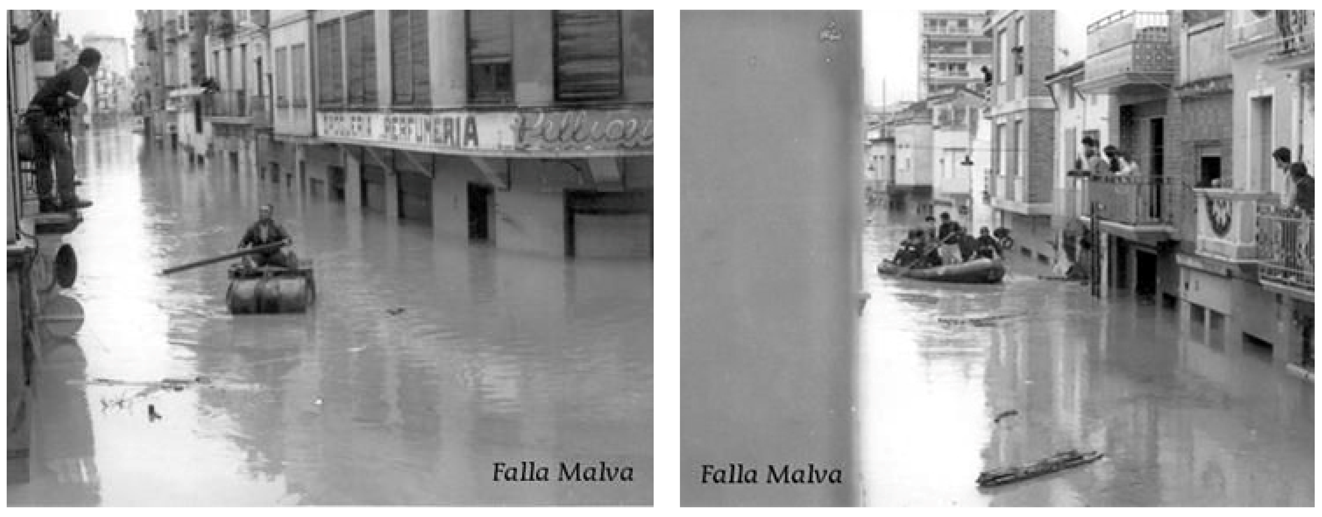
3, almost 17 times higher than the capacity of the design. The power cuts caused by the heavy rain prevented the floodgates from opening so that the level of the water from the rivers Júcar and Escalona caused the dam to overflow, breaking the central sector and submerging Alzira in over 2 metres of water and mud (
Figure 1).
This water level was later exceeded in the 1987 flood when water levels reached 2.8 m in the historic town centre of Alzira, with a maximum flow of 5200 m
3/s in the floodplain [
25]. Archaeological studies by Butzer et al. [
26] reconstruct the variations in the hydrological regime of the river Júcar in Alzira. According to these studies, until the 11th century the peak discharges were gentler, while from the mid-11th century the strata suggest catastrophic floods in the city. Despite the numerous floods, the city of Alzira still preserves its architectural heritage, while “La Vila”, its historic town centre, is listed as an Asset of Cultural Interest, the highest level of protection granted by the Comunitat Valenciana [
27].
As a case study the analysis of Alzira aims to provide a better understanding and knowledge of earthen architecture in terms of flood vulnerability. Very few studies have been conducted to assess the vulnerability of earthen architecture to floods.
This study proposes a methodology for vulnerability assessment based on the intrinsic characteristics of buildings exposed to flood risk. This approach considers the building as an asset and makes it possible to assess the vulnerability of heritage buildings faced by potential floods, thus preventing possible damage. Moreover, the simple methodology proposed aims to provide a very fast and versatile vulnerability assessment tool for heritage buildings, which can be used in various historic contexts.
The determination of the vulnerability level, focusing on the design of flood risk prevention and mitigation measures, will be the starting point for future research, aiming to prevent the disappearance of a traditional architectural technique, an important part of the cultural heritage of the Iberian Peninsula.
2. Geographical Setting and Geological Framework
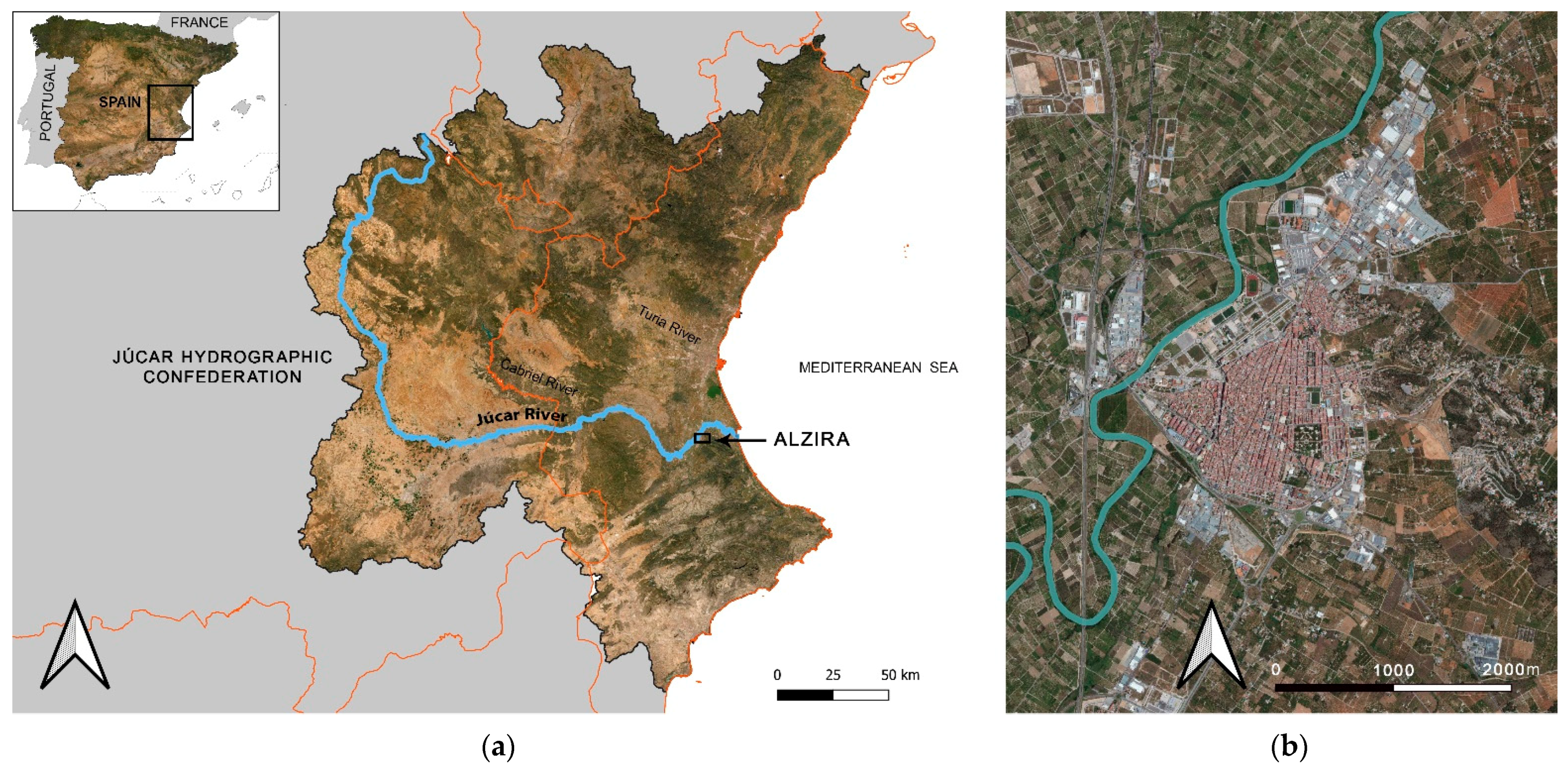
The Júcar is a long meandering Mediterranean river which crosses the Spanish provinces of Cuenca, Albacete, and Valencia before reaching the Mediterranean Sea. Known in Roman times as the Sucro, the Júcar is born at an elevation of 1700 metres, on the south slope of the Cerro de San Felipe in the Montes Universales, where another two Spanish rivers, the Tajo and the Turia, are also born. The course of the river is divided into three segments based on morphology: the initial section which crosses the mountainous terrain of Cuenca; the middle course between Villalba de la Sierra and the Tous dam, where the river Cabriel and the Cortes II reservoir converge; and the lower course between the Tous dam and Cullera (
Figure 2).
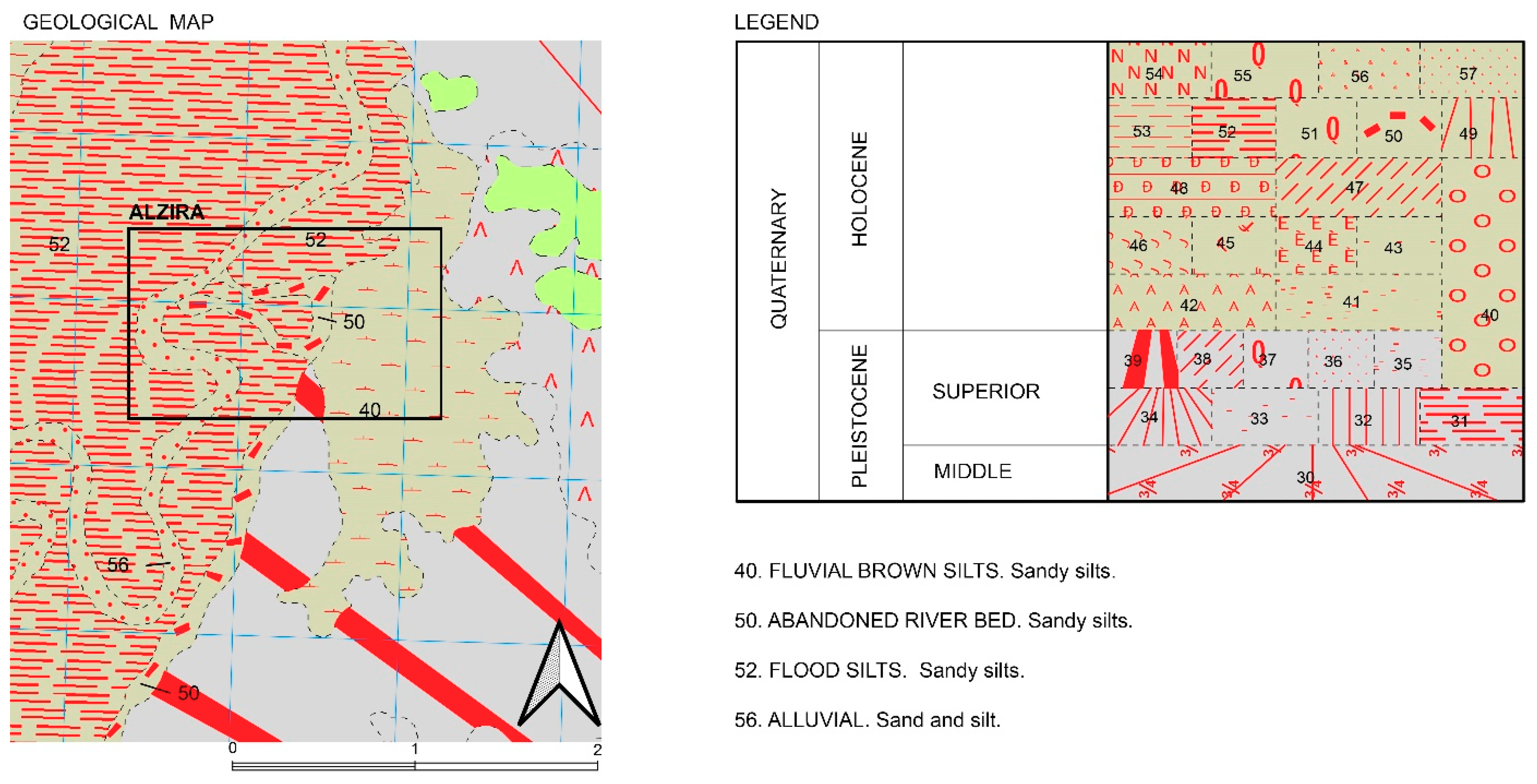
The river’s long course flows into the estuary of the Estany de Cullera. The sediments in the basin of the river Júcar formed in the Mesozoic. During the Cenozoic and Quaternary, the valley created was gradually filled with deposits from the erosion of nearby reliefs and deposits from rivers and lakes (
Figure 3). It is thought that the central floodplain of Valencia was formed from the action of the rivers Júcar and Turia in this period [
28].
In the region of Vallfarta the Júcar forms twenty meanders, changing to five meanders where it coincides with the river Magro, where the bottleneck formed promotes sedimentation. The meander of the Júcar is unequal due to the sedimentation of a large amount of detritus from mountainous areas. This geological model results in the formation of large sediment deposits, restricting the input of solid and liquid flow with output through a small spillway [
29,
30,
31].
The hydrological regime of the river is pluvio-nival at the head and Mediterranean in the final section, presenting a maximum (autumn/winter) and minimum (summer) flow per year. In addition, there is a characteristic disproportion between ordinary and extraordinary flows. The major flows are observed in winter and spring due to the concentration of rainfall, and they decrease in the warmer months [
32,
33]. The severity of the floods is determined, among other factors, by the geological features and hydrological regime of the river.
3. Materials and Methods
The severity of the floods of the Júcar is due to a series of natural and anthropic factors, including the morphology of the Júcar basin and its floodplain, which play a key role in the evolution of the floods. The Júcar basin area studied is large and low, two characteristics which together with the formation of the floodplain favour the formation of a complex pattern of flooding flows. These flows diverge when entering the floodplain to converge near Alzira, where there is strong sedimentation in the meandering Júcar. The progressive sedimentation and the slight slope of the river have caused the riverbed level to rise and have increased the floodplain. The consequences of these geomorphological changes have been key in the formation of the characteristic floods. In fact, given the new geometry of the floodplain, small floods could also affect extensive areas, causing serious damage. However, anthropic factors such as deforestation and the construction of transport infrastructures have contributed to more intense floods [
1]. Alzira is currently classed as a floodable area, according to PATRICOVA (Plan de Acción Territorial sobre Prevención del Riesgo de Inundación en la Comunitat Valenciana) guidelines, which establish six risk levels based on frequency and water depth [
34]. Alzira is affected by a high average risk of levels 2 and 4 (frequency of 25–100 years and a water depth lower or higher than 80 cm) within this danger scale (
Table 1).
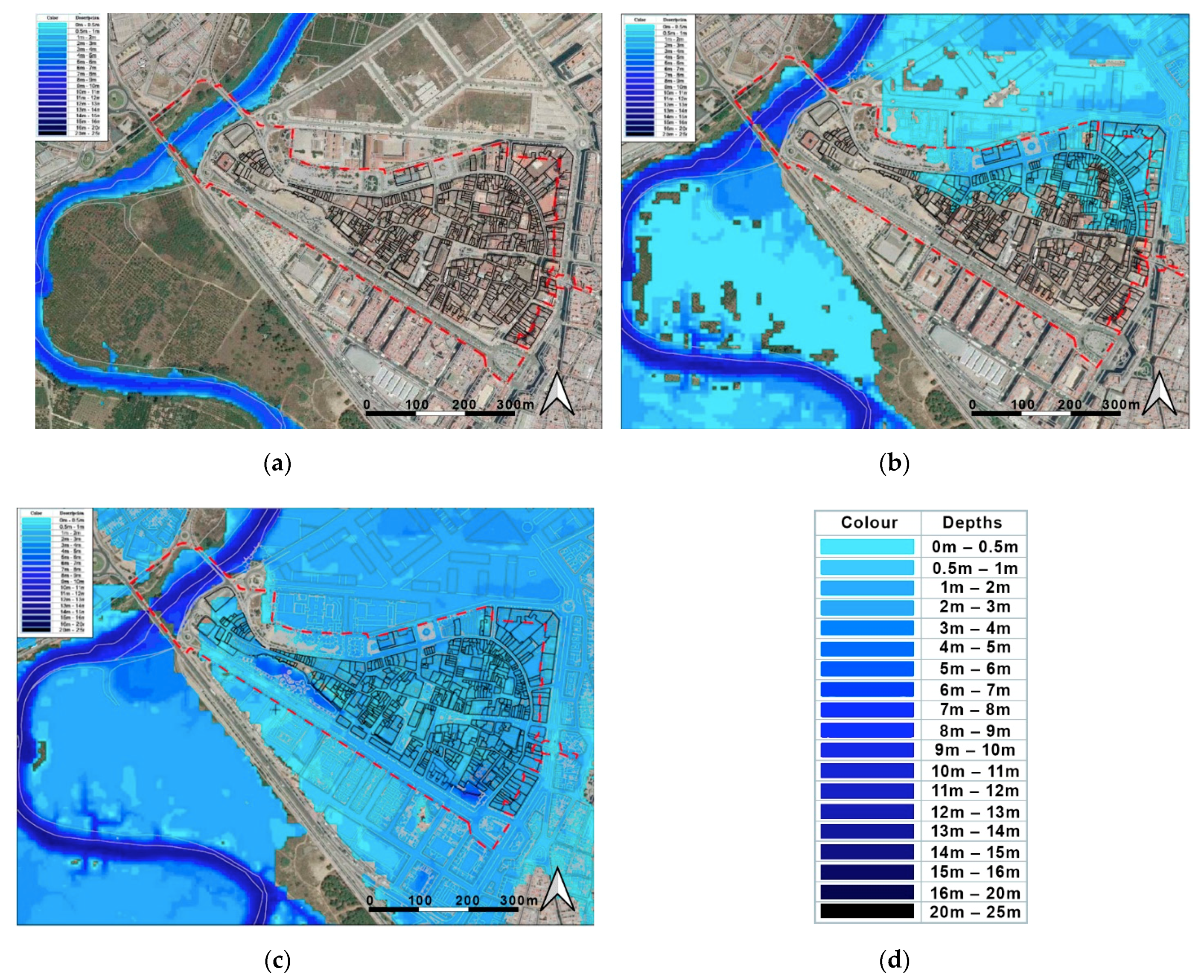
According to the SNCZI (Sistema Nacional de Cartografía de Zonas Inundables) map of floodable areas [
3], in a 100-year return period the water depths would affect the northeast area and in a 500-year return period they would affect the whole historic centre of Alzira (
Figure 4).
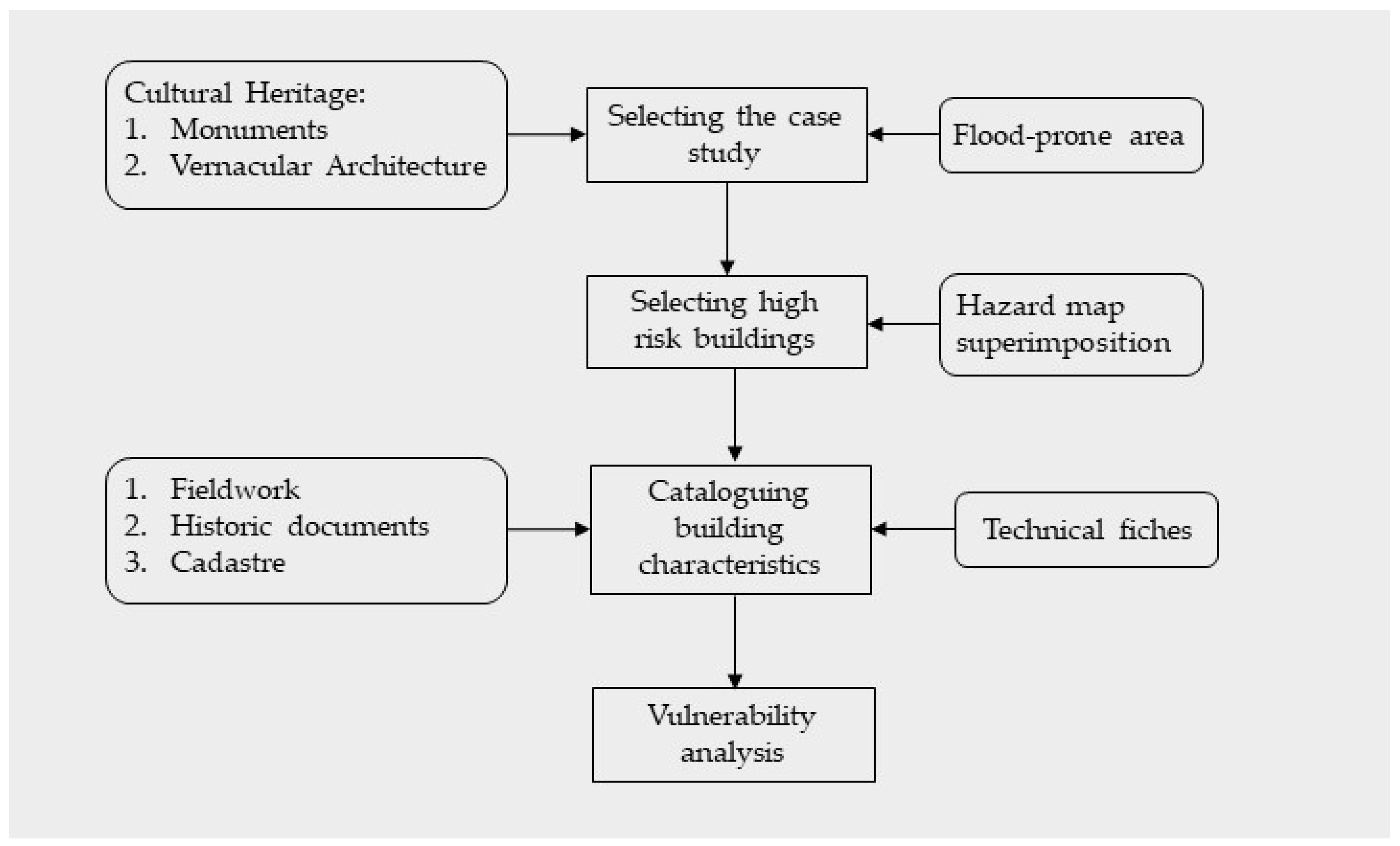
The methodology proposed for the assessment of the vulnerability of heritage earthen architecture in the event of floods was organized into phases (
Figure 5), compiling, analysing, and contrasting data [
35,
36,
37].
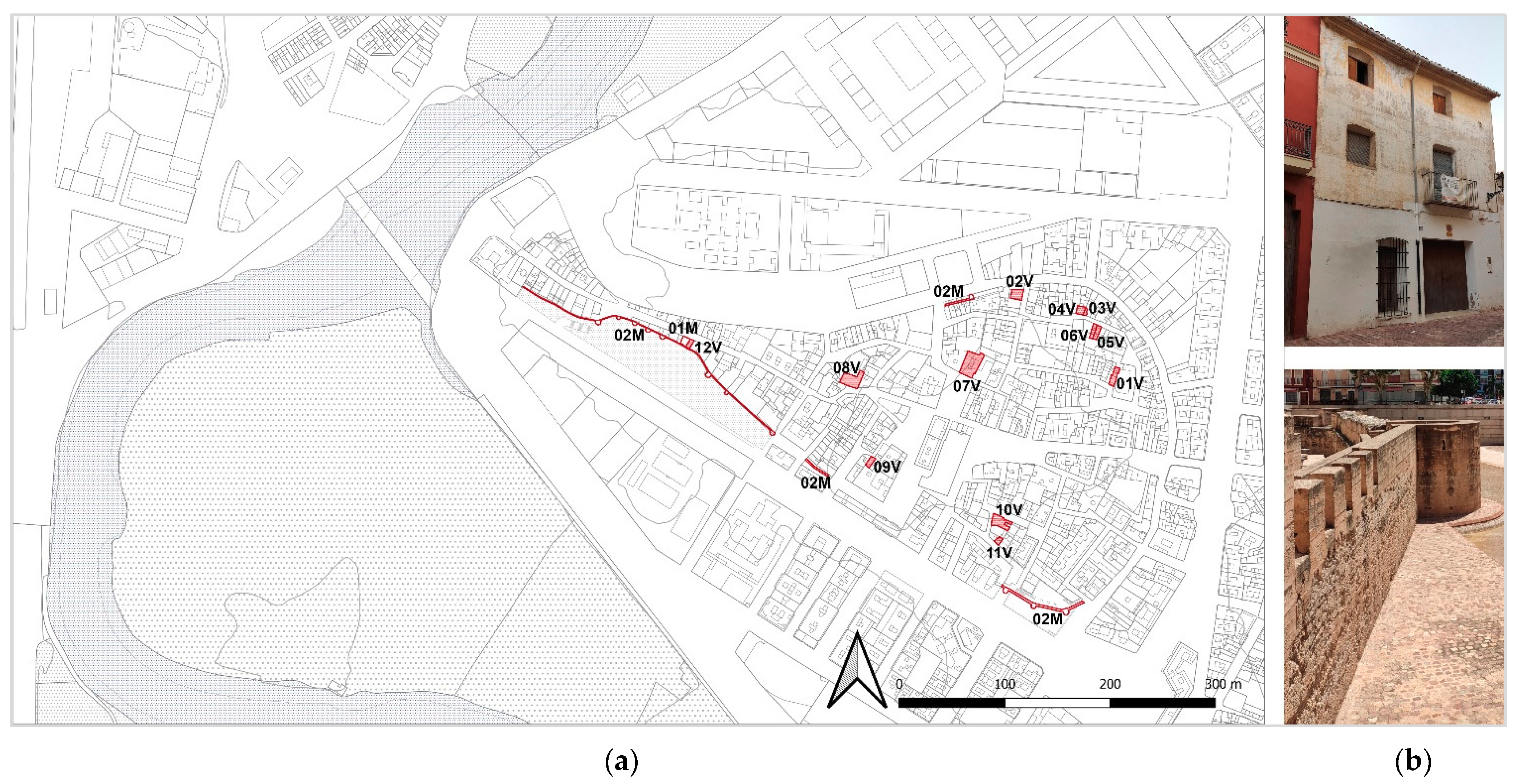
Several resources were used to select buildings. Fieldwork was used to carry out an initial selection of buildings which was subsequently reviewed using historic documents and documents from the cadastre and the Special Protection Plan of the Vila de Alzira [
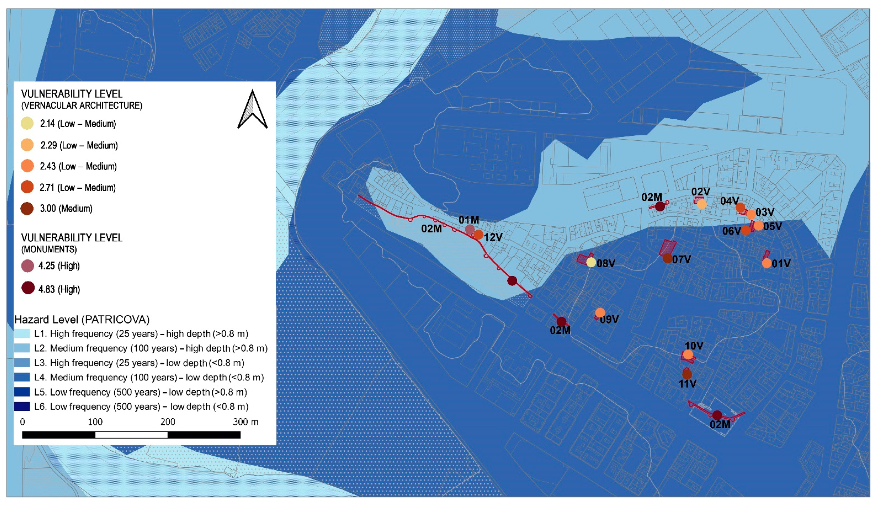
38]. This information was contrasted with that provided by the MUMA museum (Museo Municipal de Alzira), identifying 12 vernacular heritage dwellings and 2 examples of monumental architecture (
Table 2;
Figure 6).
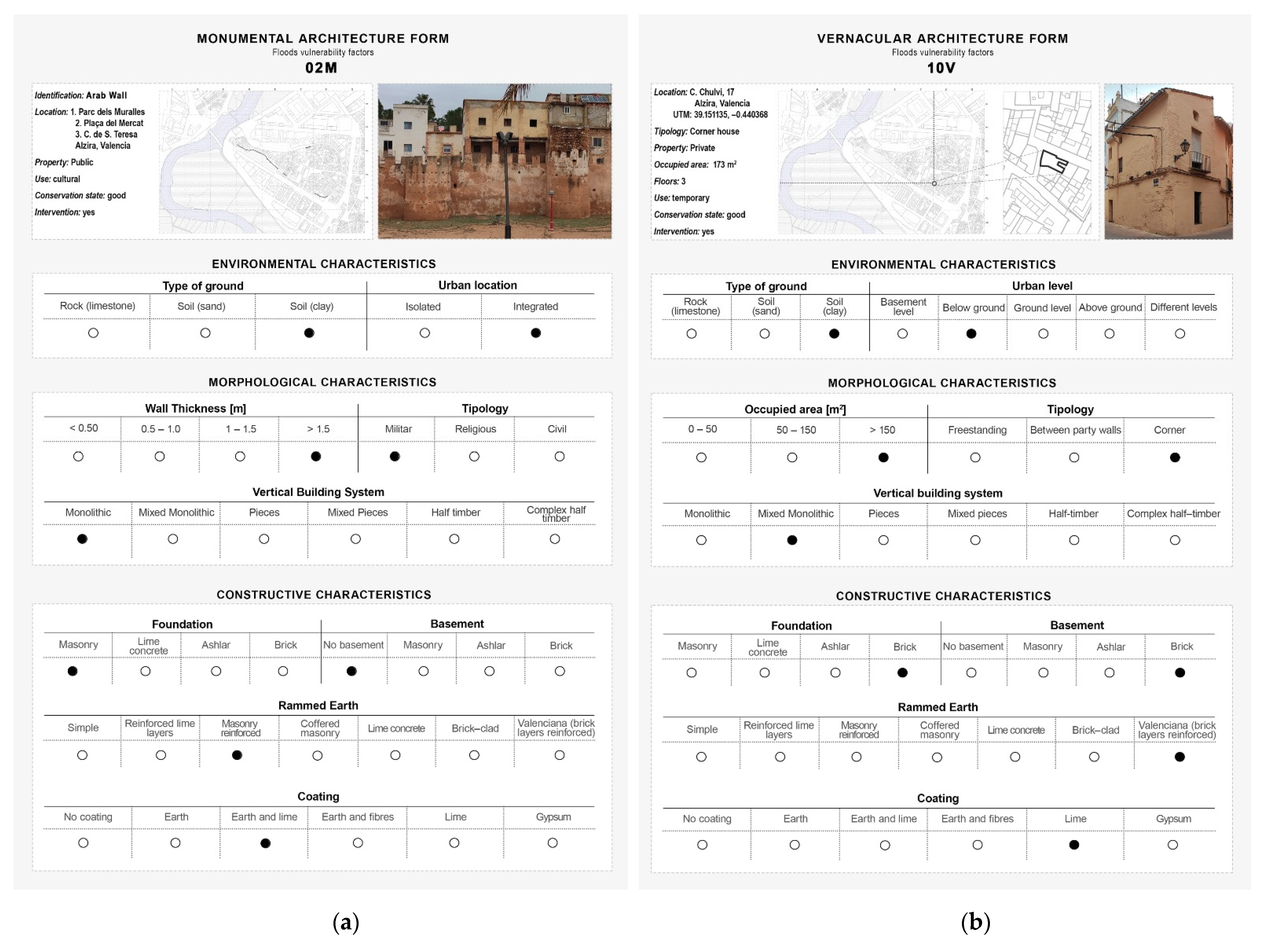
Finally, the case study map was superimposed on a map showing the flood risks for the city of Alzira. Both maps were drawn up by PATRICOVA (Plan de Acción Territorial sobre Prevención del Riesgo de Inundación en la Comunitat Valenciana) [
34]. After the superimposition, the buildings were catalogued using technical fiches divided into sections identifying the architectural, morphological, and constructive features most closely linked to the effects of the floods (
Figure 7). Fourteen types were identified during the fieldwork.
Despite knowing the risk level of the case study analysed, there is little information on flood damage, preventing the use of depth-damage graphs typically employed in vulnerability assessment. In this study, vulnerability was analysed by evaluating the expected response of the building, based on the intrinsic characteristics of the building itself and its conservation condition. This limits the number of parameters to those only relevant to the building and its immediate surroundings, highly useful in the absence of detailed information on previous damage to buildings caused by floods. In the present study, the parameters are not weighted as they are considered equally critical in the overall response of the building. This methodology is in agreement with other studies investigating flood vulnerability of historic buildings [
16,
17].
The study of intrinsic characteristics has focused on measuring environmental, morphological, and constructive characteristics. The influence of surroundings [
39], including the position in the urban context and the typology of the terrain and the correlation between the building and the urban level of the ground, has been considered. The typology of the terrain was assessed through maps from the IGME (Geological and Mining Institute of Spain) and data from the geo-archaeological register of Alzira [
26]. The morphological features highlight the characteristic aspects of the buildings which define their form and composition. Analysis of their vulnerability to floods assessed the footprint, building typology, vertical constructive system, and wall thickness, which are used to measure the building’s exposure to risk. Constructive characteristics such as architectural elements (foundations, plinth, type of wall, rendering), materials and constructive techniques were analysed, providing information on the vulnerability of the building. In order to obtain the parameters for assessment, each characteristic was assigned a numerical value, from 1 (very low) to 5 (very high), on a scale of values by level of influence. The vulnerability value of each parameter was chosen according to its response to flood risk, as vulnerability is considered a function of this risk. For example, a rammed earth wall without a plinth will be more vulnerable than a rammed earth wall with a masonry plinth, as it will be more prone to collapse due to the capillary absorption of water (
Table 3).
The effects of material weathering and structural damage have only been considered for monumental architecture with various forms of material weathering linked to the risk of flooding (
Table 4). The conservation state of the historic buildings can be considered as an index of their resistance to the effects of a specific hazard.
Dividing the total number of parameters by that of parameters used an average vulnerability value was obtained for each earthen building, easily comparable following a vulnerability scale from 1 to 5.
4. Results
Using this methodology, the data necessary for vulnerability assessment were obtained in an initial phase. Fieldwork has provided data on the constructive characteristics of vernacular architecture (
Table 5) and monumental architecture (
Table 6), as well as data on material weathering (
Table 7).
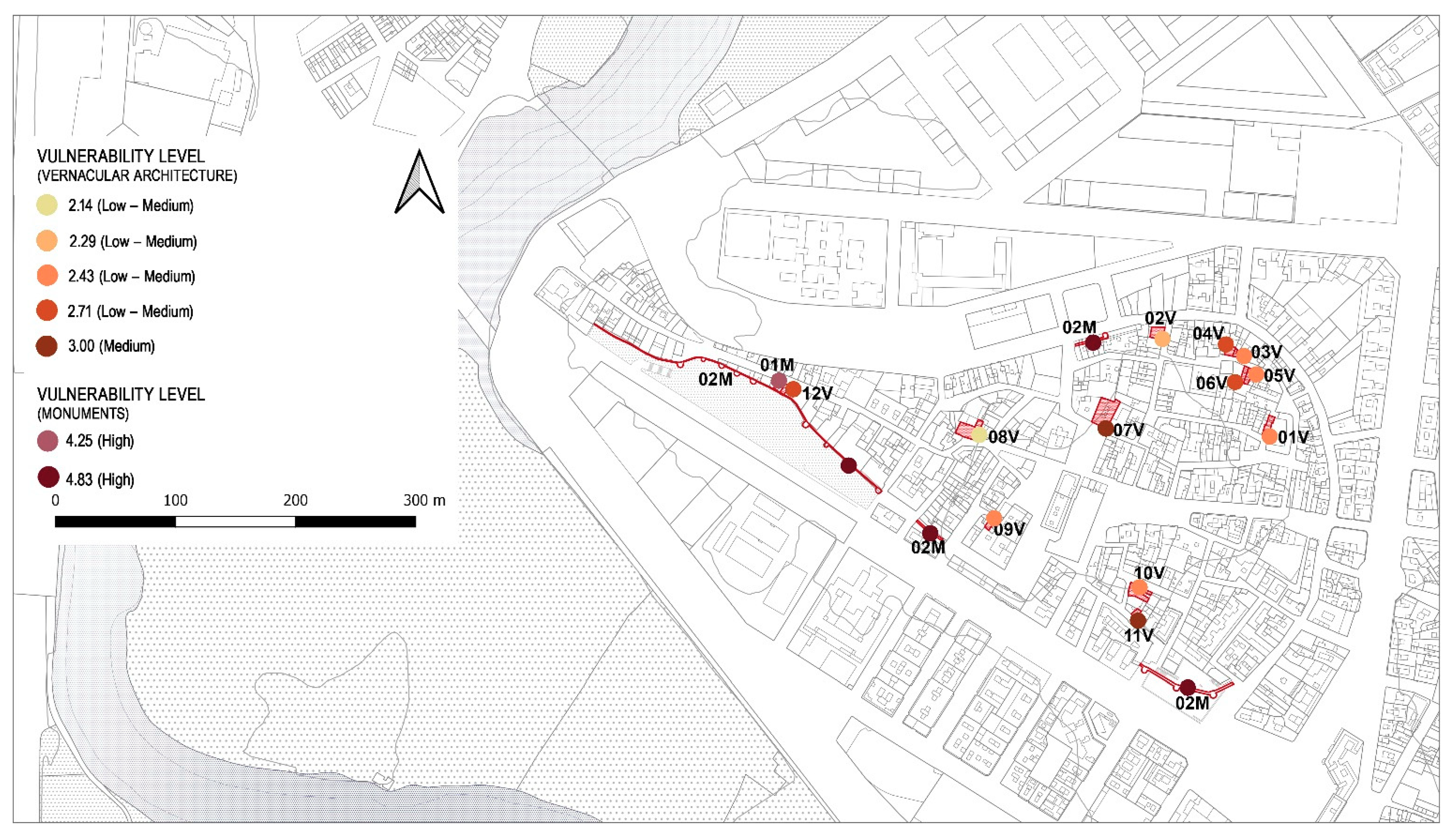
Following data collection, the vulnerability value of individual case studies was calculated (
Table 8), obtaining values of 2.14–3.00 for vernacular architecture and of 4.25–4.83 for monumental architecture (
Figure 8).
Based on the intermediate vulnerability levels 75% of samples are in the medium-low vulnerability level, 13% at medium level, and 8% at low level. It should also be emphasized that these results were obtained analysing case studies with the same constructive system and comparable characteristics. When evaluating monumental architecture, the values calculated also take into account the effect of material weathering, obtaining a minimum value of 4.25 and a maximum value of 4.38. According to the proposed scale these vulnerability levels are considered to be high (
Figure 9).
The analysis of results leads to several considerations. The assessment of the vulnerability of vernacular architecture provides a minimum value (2.14) for the building “Casa del Empeño” (08V), while the maximum value (3.00) is reached for Palacio Casassus (07V) and the dwelling located on Sang Street 10 (11V). The Casa del Empeño and the Palacio Casassus fall within the same constructive and building typology. However, calculating the vulnerability level has provided very different results given the varying degrees of influence of some parameters. Firstly, the terrain parameter, sandy in one case and clayey in the other, results in a difference of two points in this value. Lime rendering is also found on the Casa del Empeño, while the walls of the Palacio Casassus are left bare. This leads to a major variation in the vulnerability level of both buildings, despite the great similarities in their constructive typology. Thus, the presence of rendering improves resistance to the effects of water and the formation of damp. Therefore, the maximum vulnerability levels were found not only in a grand mansion, Palacio Casassus (07V), but also in a far smaller traditional dwelling (11V). In this regard it should be noted that parameters such as the surface occupied by buildings and their rendering were decisive in the calculation of the vulnerability level. The Palacio has a footprint of 150 m
2 while the traditional dwelling is smaller and occupies approximately 50 m
2. However, the difference in the scores for this parameter is balanced by the rating assigned to the rendering parameter, lime in the dwelling and none in the case of the Palacio (
Table 9).
The comparison of the results obtained in the calculation of the vulnerability of this monumental architecture provides interesting data on the influence of the state of conservation of monuments in the event of flooding. In fact, the maximum vulnerability level is observed in the Muralla Árabe (02M), which presents several forms of material weathering (erosion at the springing, erosion of the rammed earth wall, and erosion of the rendering) which worsen resistance during floods, allowing water infiltration, and threatening the cohesion of the system (
Table 10). In addition, in the case of monumental architecture the constructions analysed share the same constructive system so that the difference between the two levels of vulnerability can be attributed to material weathering of the walls.
5. Discussion
The present study has focused on flood vulnerability assessment of earthen historic buildings in the historic centre of the heritage city of Alzira, Spain. As historic buildings are an irreplaceable cultural heritage, reducing their vulnerability is crucial to reducing flood risk and preventing their disappearance. This study has highlighted that the most vulnerable buildings are those which are poorly conserved, whose walls do not have coating and which are built on clayey soil. Building conservation conditions have proved to be a key feature in assessing flood vulnerability. Despite the constructive and typological differences of the buildings analysed, this result agrees with those of Stephenson and D’Ayala [
16]. In their quantitative analysis of the flood vulnerability of historic buildings in England, they found that the vulnerability rating increased in buildings in very poor condition. Some of the buildings assessed in the present study display erosion in the walls, a form of weathering which makes them more vulnerable to the action of water. However, different forms of material weathering can be critical to building conservation conditions. Ortiz et al. [
18], in their assessment of the vulnerability of monumental buildings in the historic centre of Seville, Spain, point out that the proximity of the currently diverted river, the presence of groundwater, and soil permeability damage the lower sections of the heritage buildings studied. Among the most relevant forms of material weathering, Ortiz et al. [
18] identify efflorescence and patches of damp associated with capillary action. Therefore, the results obtained by Ortiz et al. [
18] in the context of the heritage city of Seville also show the influence of building condition in the evaluation of the vulnerability of historical buildings. In the assessment of the vulnerability of the historic buildings of the city of Guimarães, in Portugal, Miranda and Ferreira [
40] find that most of the buildings studied are in good condition, with only a few cases with moderate structural damage suffering from damp. However, most of these buildings are in a flood risk area and therefore potentially at risk. This result is comparable with the results obtained in the present study for vernacular buildings which, unlike monuments, are kept in good condition. Therefore, in this case, vulnerability depends on the intrinsic characteristics of the buildings analysed and their potential exposure to floods. Lanza [
41] uses the collection of historical data on the frequency and magnitude of flood events observed over the past century to draw up a map of the historic centre of Genoa, Italy. This map shows the vulnerability of its artistic and monumental heritage to flooding. However, it only considers the frequency of flooding episodes near vulnerable heritage buildings, rather than their characteristics. Arrighi et al. [
42] conducted a flood risk study of the city of Florence, cataloguing the buildings at three risk levels (high, medium, and low). According to the results obtained, represented in a risk map, most of the buildings have been classified as high and medium risk.
Strategies can be designed to reduce the vulnerability of historic buildings once this level is known. Intervention strategies may be structural or non-structural and may be aimed at consolidating and improving the conditions of the environment or the building itself. According to D’Alaya et al. [
17] the combined use of structural and non-structural measures to increase the resilience of buildings in a heritage district in Kuala Lumpur, Malaysia, has been very effective on the urban scale, halving economic losses. The evaluation of economic losses is influenced by several factors that need to be assessed when estimating flood damage, as seen in Garrote and Bernal [
12]. In order to prevent and mitigate flood damage it is essential to design strategies to reduce the impact of floods on architectural heritage. Emergency plans and guidelines are crucial to reducing damage and loss. In addition, the constant maintenance of historic buildings is fundamental to conserving their structural integrity. The identification of structural damage and material weathering is essential when deciding on the most appropriate interventions, restoring deteriorated elements and materials, and consolidating and reinforcing structural elements. Temporary protective measures such as increasing the strength of light doors or walls, and introducing surface protection for the materials and structures most sensitive to water action (adobe walls, rammed earth walls, clay coating), can also prevent further damage [
43,
44]. The implications of economic factors, together with the design of appropriate restoration measures, will be developed as a research topic in the next stage of this study.
The proposed methodology has been developed using the minimum number of parameters, included in three main categories, and with a simple evaluation system applicable to other case studies with an easy comparison of results. In the present study a total of sixteen parameters has been used, whereas Stephenson and D’Ayala [
16] reduce the parameters to the minimum number of seven parameters, applicable to individual building typologies. In contrast, Gandini et al. [
15] developed an assessment tree composed of two requirements, eight criteria, and fourteen parameters. These studies also provide information on uncertainty relating to the parameters involved in this methodology. This uncertainty is due to the subjectivity of the indicators, sometimes depending on the experience and knowledge of surveyors, who may assess the conservation status and other parameters differently. Therefore, the application of this methodology to other case studies and its implementation in land planning involves adapting the parameters to each specific context, aiming to establish a set of parameters to reduce uncertainty.
The assessment of the intrinsic vulnerability of buildings ascertains their vulnerability in the face of flooding events regardless of the risk level of the site. Although this study has not incorporated risk exposure assessments for individual buildings this will be covered in future lines of research, thus providing a more comprehensive risk analysis and assessment. Moreover, the use of unweighted parameters provides a qualitative assessment of the vulnerability of each building. The next phase of this research will study and introduce coefficients for a more quantitative assessment to form the basis for further analysis, extended to more heritage sites in the Iberian Peninsula.


