
How Flood Hazard Maps Improve the Understanding of Ecologically Active Floodplains

Abstract
1. Introduction
2. Materials and Methods
2.1. Setting
2.2. Data and Data Processing
3. Results
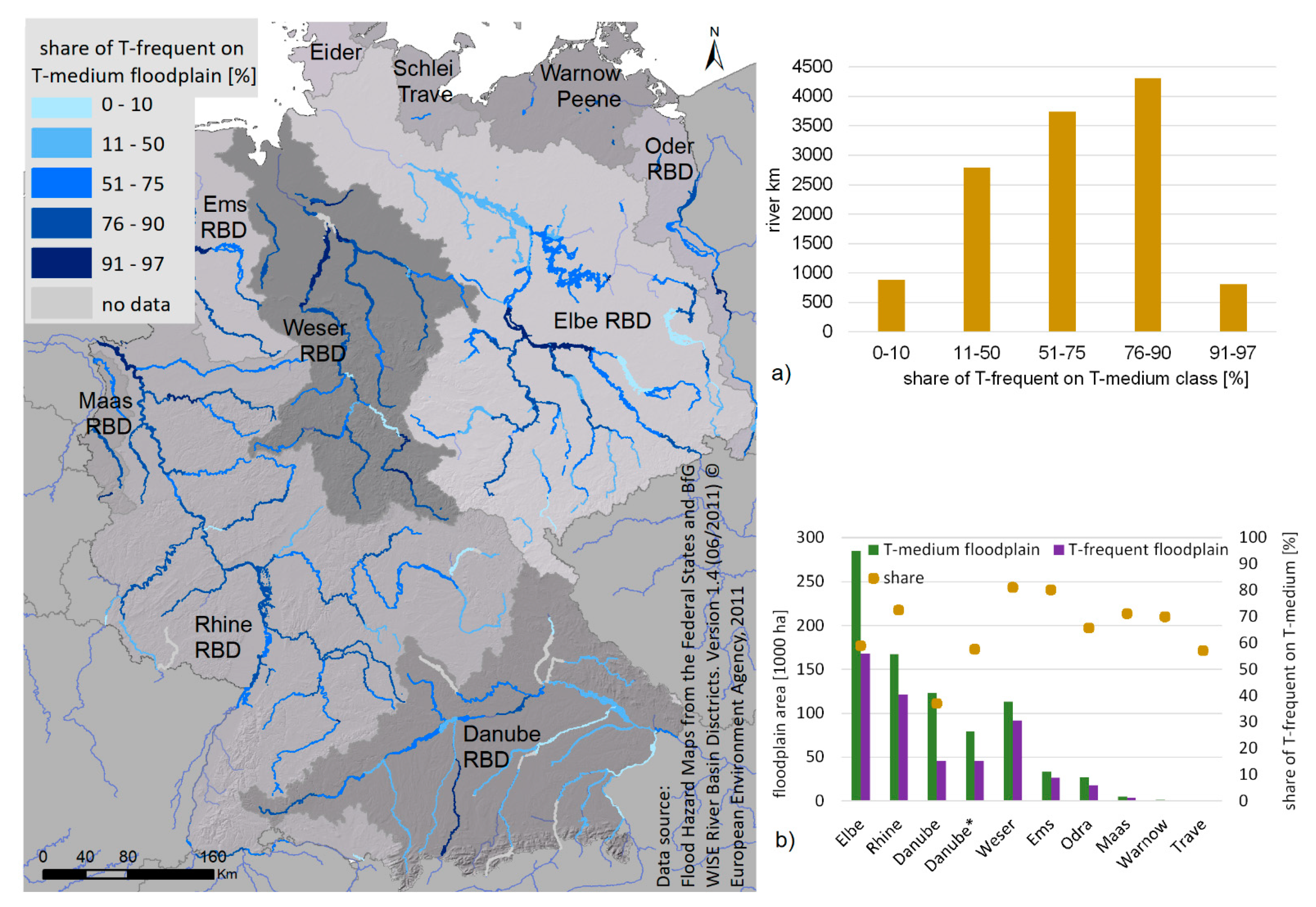
3.1. Comparison of Extent, Water Depth and Static Water Volume between T-Frequent and T-Medium Floodplains
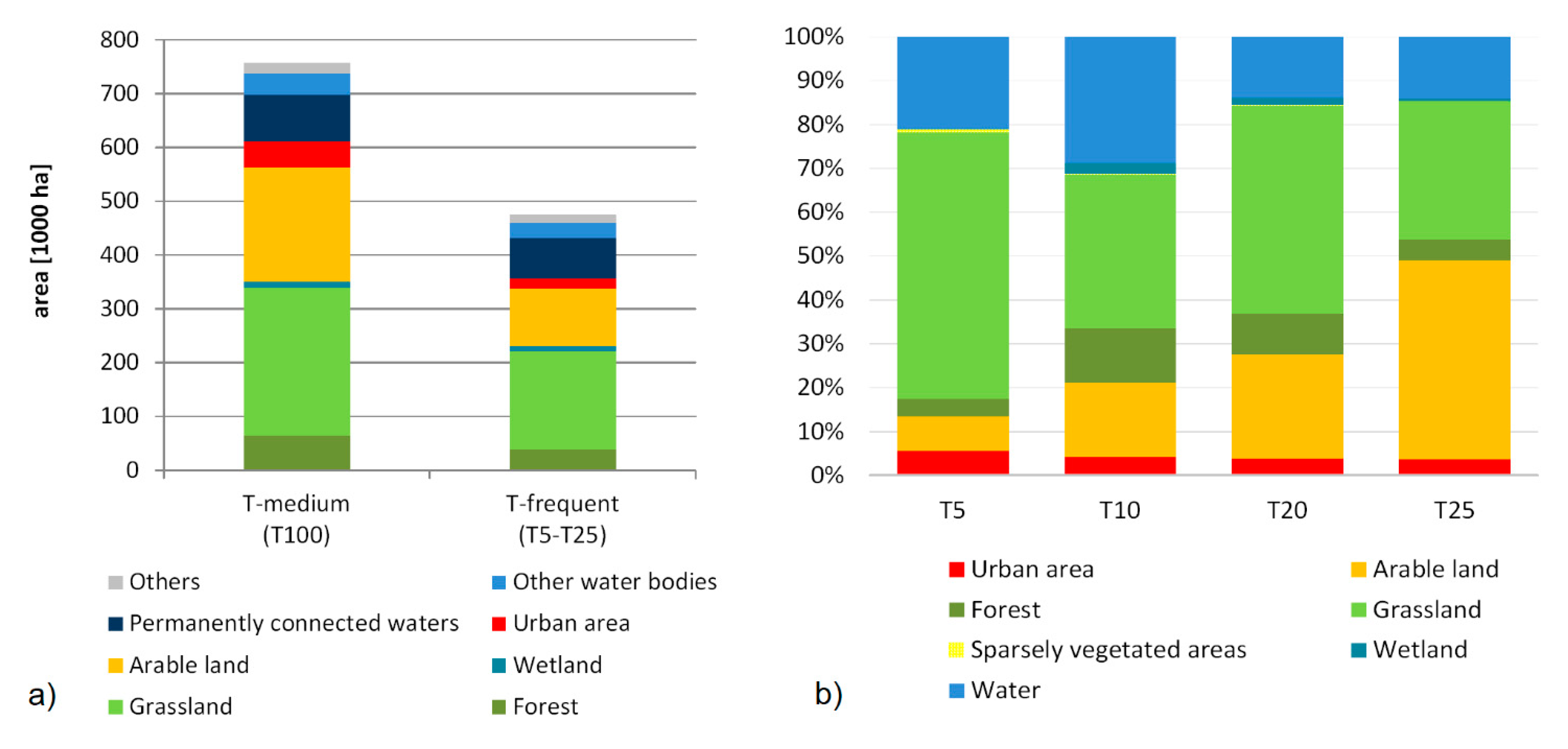
3.2. Indicating Naturalness: Land Use, Protected Habitats and Vegetation Cover
3.3. Actual and Statistical Inundation in T-Frequent Floodplains
4. Discussion
4.1. Delineating Floodplain Borders Considering Their Importance for Regulation Functions
4.2. Indicator for Naturalness of Floodplains and Ecosystem Functioning
4.3. Reliability of Results: Limits of FHM Data
5. Conclusions
Supplementary Materials
Author Contributions
Funding
Institutional Review Board Statement
Informed Consent Statement
Data Availability Statement
Acknowledgments
Conflicts of Interest
References
- Costanza, R.; D’Arge, R.; de Groot, R.; Farber, S.; Grasso, M.; Hannon, B.; Limburg, K.; Naeem, S.; O’Neill, R.; Paruelo, J.; et al. The value of the world’s ecosystem services and natural capital. Nature 1997, 387, 253–260. [Google Scholar] [CrossRef]
- Junk, W.; Bayley, P.B.; Sparks, R.E. The flood pulse concept in river-floodplain systems. Can. Spec. Publ. Fish. Aquat. Sci. 1989, 106, 110–127. [Google Scholar]
- Naiman, R.J.; Décamps, H. The ecology of interfaces: Riparian zones. Annu. Rev. Ecol. Syst. 1997, 28, 621–658. [Google Scholar] [CrossRef]
- Ward, J.V. Riverine landscapes: Biodiversity patterns, disturbance regimes, and aquatic conservation. Biol. Conserv. 1998, 83, 269–278. [Google Scholar] [CrossRef]
- Poff, N.L.; Allan, J.D.; Bain, M.B.; Karr, J.R. The natural flow regime: A new paradigm for riverine conservation and restoration. BioScience 1997, 47. [Google Scholar] [CrossRef]
- Fernandes, M.R.; Aguiar, F.C.; Ferreira, M.T. Assessing riparian vegetation structure and the influence of land use using landscape metrics and geostatistical tools. Landsc. Urban Plan. 2011, 99, 166–177. [Google Scholar] [CrossRef]
- Leyer, I. Effects of dykes on plant species composition in a large lowland river floodplain. River Res. Appl. 2004, 20, 813–827. [Google Scholar] [CrossRef]
- Jackson, M.B.; Colmer, T.D. Response and adaptation by plants to flooding stress. Ann. Bot. 2005, 96, 501–505. [Google Scholar] [CrossRef]
- Weissteiner, C.J.; Ickerott, M.; Ott, H.; Probeck, M.; Ramminger, G.; Clerici, N.; Dufourmont, H.; De Sousa, A.M.R. Europe’s green arteries—A continental dataset of riparian zones. Remote Sens. 2016, 8, 925. [Google Scholar] [CrossRef]
- Brunotte, E.; Dister, E.; Gunther-Diringer, D.; Koenzen, U.; Mehl, D. Flussauen in Deutschland–Erfassung und Bewertung des Auenzustandes. In Naturschutz und Biologische; Bad Godesberg: Bonn, Germany, 2009. [Google Scholar]
- Schulz-Zunkel, C.; Krueger, F. Trace metal dynamics in floodplain soils of the river elbe: A review. J. Environ. Qual. 2009, 38, 1349–1362. [Google Scholar] [CrossRef]
- Weaver, J.C.; Feaster, T.D.; Gotvald, A.J. Magnitude and Frequency of Rural Floods in the Southeastern United States, through 2006—Volume 2, North Carolina. 2009, U.S. Geological Survey Scientific Investigations Report 2009–5158; BiBlioGov: Reston, VA, USA, 2011; p. 111. [Google Scholar]
- Chapin, D.M.; Beschta, R.L.; Shen, H.W. Relationships between flood frequencies and riparian plant communities in the Upper Klamath Basin, Oregon. J. Am. Water Resour. Assoc. 2002, 38, 603–617. [Google Scholar] [CrossRef]
- Hughes, F.M.R.; Rood, S.B. Allocation of river flows for restoration of floodplain forest ecosystems: A review of approaches and their applicability in Europe. Environ. Manag. 2003, 32, 12–33. [Google Scholar] [CrossRef] [PubMed]
- BMU; BfN. Auenzustandsbericht. Flussauen in Deutschland; Bundesamt fur Naturschutz: Bonn, Germany, 2009. [Google Scholar]
- Erős, T.; Bányai, Z. Sparing and sharing land for maintaining the multifunctionality of large floodplain rivers. Sci. Total Environ. 2020, 728, 138441. [Google Scholar] [CrossRef] [PubMed]
- Entwistle, N.S.; Heritage, G.L.; Schofield, L.A.; Williamson, R.J. Recent changes to floodplain character and functionality in England. CATENA 2019, 174, 490–498. [Google Scholar] [CrossRef]
- Grizzetti, B.; Liquete, C.; Pistocchi, A.; Vigiak, O.; Zulian, G.; Bouraoui, F.; De Roo, A.; Cardoso, A.C. Relationship between ecological condition and ecosystem services in European rivers, lakes and coastal waters. Sci. Total Environ. 2019, 671, 452–465. [Google Scholar] [CrossRef]
- Scholz, M.; Mehl, D.; Steinhauser, A.; Kasperidus, H.D. Ökosystemfunktionen von Flussauen–Analyse und Bewertung von Hochwasserretention, Nährstoffrückhalt, Kohlenstoff, Treibhausgasemissionen und Habitatfunktion. In Naturschutz und Biologische; Bad Godesberg: Bonn, Germany, 2012. [Google Scholar]
- EC. Directive 2007/60/EC of the European Parliament and of the Council of 23 October 2007 on the assessment and management of flood risks. Off. J. Eur. Union 2007, 288, 1–8. [Google Scholar]
- Wolman, G.M.; Miller, J.P. Magnitude and frequency of forces in geomorphic processes. J. Geol. 1960, 68, 54–74. [Google Scholar] [CrossRef]
- Schulte in den Bäumen, H.; Többen, J.; Lenzen, M. Labour forced impacts and production losses due to the 2013 flood in Germany. J. Hydrol. 2015, 527, 142–150. [Google Scholar] [CrossRef]
- Venohr, M.; Hirt, U.; Hofmann, J.; Opitz, D.; Gericke, A.; Wetzig, A.; Natho, S.; Neumann, F.; Hurdler, J.; Matranga, M.; et al. Modelling of nutrient emissions in river systems–Moneris–Methods and background. Int. Rev. Hydrobiol. 2011, 96, 435–483. [Google Scholar] [CrossRef]
- Clerici, N.; Paracchini, M.L.; Maes, J. Land-cover change dynamics and insights into ecosystem services in European stream riparian zones. Ecohydrol. Hydrobiol. 2014, 14, 107–120. [Google Scholar] [CrossRef]
- Clerici, N.; Weissteiner, C.J.; Paacchini, M.L.; Boschetti, L.; Baraldi, A.; Strobl, P. Pan-European distribution modelling of stream riparian zones based on multi-source Earth Observation data. Ecol. Indic. 2013, 24, 211–223. [Google Scholar] [CrossRef]
- UNEP-WCMC; IUCN. Protected Planet: [The World Database on Protected Areas (WDPA)]. Available online: www.protectedplanet.net (accessed on 17 December 2019).
- UNEP-WCMC. World Database on Protected Areas User Manual 1.5. UNEP-WCMC. 2017. Available online: http://wcmc.io/WDPA_Manual (accessed on 17 December 2019).
- Schindler, S.; O’Neill, F.H.; Biro, M.; Damm, C.; Gasso, V.; Kanka, R.; van der Sluis, T.; Krug, A.; Lauwaars, S.G.; Sebesvari, Z.; et al. Multifunctional floodplain management and biodiversity effects: A knowledge synthesis for six European countries. Biodivers. Conserv. 2016, 25, 1349–1382. [Google Scholar] [CrossRef]
- BfN. Potential Natural Vegetation of Germany; Bundesamt fur Naturschutz: Bonn, Germany, 2011. [Google Scholar]
- Polley, H.; Heinrich, J. Aufnahmeanweisung für die dritte Bundeswaldinventur (BWI) (2011–2012), 2nd ed.; Johann Heinrich von Thünen Institute: Braunschweig, Germany, 2011. [Google Scholar]
- Natho, S.; Thieken, A.H. Implementation and adaptation of a macro-scale method to assess and monitor direct economic losses caused by natural hazards. Int. J. Disaster Risk Reduct. 2018, 28, 191–205. [Google Scholar] [CrossRef]
- Stammel, B.; Amtmann, M.; Gelhaus, M.; Cyffka, B. Change of regulating ecosystem services in the Danube floodplain over the past 150 years induced by land use change and human infrastructure. Erde 2018, 149, 145–156. [Google Scholar] [CrossRef]
- Natho, S.; Venohr, M.; Henle, K.; Schulz-Zunkel, C. Modelling nitrogen retention in floodplains with different degrees of degradation for three large rivers in Germany. J. Environ. Manag. 2013, 122, 47–55. [Google Scholar] [CrossRef]
- EEA. Flood Risks and Environmental Vulnerability: Exploring the Synergies Between Floodplain Restoration, Water Policies and Thematic Policies; European Environmental Agency: Copenhagen, Denmark, 2016. [Google Scholar]
- Kienast, F.; Bolliger, J.; POtschin, M.; de Groot, R.S.; Verburg, P.H.; Heller, I.; Wascher, D.; Haines-Young, R. Assessing Landscape Functions with Broad-Scale Environmental Data: Insights Gained from a Prototype Development for Europe. Environ. Manag. 2009, 44, 1099–1120. [Google Scholar] [CrossRef]
- Gordon, B.A.; Dorothy, O.; Lenhart, C.F. Nutrient retention in ecologically functional floodplains: A review. Water 2020, 12, 2762. [Google Scholar] [CrossRef]
- Hupp, C.R.; Kroes, D.E.; Noe, G.B.; Schenk, E.R.; Day, R.H. Sediment trapping and carbon sequestration in floodplains of the lower Atchafalaya Basin, LA: Allochthonous versus autochthonous carbon sources. J. Geophys. Res. Bio-Geosci. 2019, 124, 663–677. [Google Scholar] [CrossRef]
- Yarnell, S.M.; Petts, G.E.; Schmidt, J.C.; Whipple, A.A.; Beller, E.E.; Dahm, C.N.; Goodwin, P.; Viers, J.H. Functional flows in modified riverscapes: Hydrographs, habitats and opportunities. BioScience 2015, 65, 963–972. [Google Scholar] [CrossRef]
- Arrighi, C.; Masi, M.; Iannelli, R. Flood risk assessment of environmental pollution hotspots. Environ. Model. Softw. 2018, 100, 1–10. [Google Scholar] [CrossRef]
- Lyubimova, T.; Lepikhin, A.; Parshakova, Y.; Tiunov, A. The risk of river pollution due to washout from contaminated floodplain water bodies during periods of high magnitude floods. J. Hydrol. 2016, 534, 579–589. [Google Scholar] [CrossRef]
- Ponting, J.; Kelly, T.J.; Verhoef, A.; Watts, M.J.; Sizmur, T. The impact of increased flooding occurrence on the mobility of potentially toxic elements in floodplain soil—A review. Sci. Total Environ. 2021, 754, 142040. [Google Scholar] [CrossRef]
- Opperman, J.J.; Luster, R.A.; McKenney, B.; Roberts, M. Ecologically functional floodplains: Connectivity, flow regime, and scale. JAWRA J. of the Am. Water Resour. Assoc. 2010, 46, 211–226. [Google Scholar] [CrossRef]
- Trush, W.J.; McBain, S.M.; Leopold, L.B. Attributes of an alluvial river and their relation to water policy and management. Proc. Natl. Acad. Sci. USA 2000, 97, 11858–11863. [Google Scholar] [CrossRef] [PubMed]
- Hayes, D.S.; Brandle, J.M.; Seliger, C.; Zeiringer, B.; Ferreira, T.; Schmutz, S. Advancing towards functional environmental flows for temperate floodplain rivers. Sci. Total Environ. 2018, 633, 1089–1104. [Google Scholar] [CrossRef]
- Bormann, H.; Pinter, N.; Elfert, S. Hydrological signatures of flood trends on German rivers: Flood frequencies, flood heights and specific stages. J. Hydrol. 2011, 404, 50–66. [Google Scholar] [CrossRef]
- Hall, J.; Arheimer, B.; Borga, M.; Bradzil, R.; Claps, P.; Kiss, A.; Kjeldsen, T.R.; Kriaciuniene, J.; Kundzewicz, Z.W.; Lang, M.; et al. Understanding flood regime changes in Europe: A state-of-the-art assessment. Hydrol. Earth Syst. Sci. 2014, 18, 2735–2772. [Google Scholar] [CrossRef]
- Merz, B.; Dung, N.V.; Apel, H.; Gerlitz, L.; Schroter, K.; Steirou, E.; Vorogushyn, S. Spatial coherence of flood-rich and flood-poor periods across Germany. J. Hydrol. 2018, 559, 813–826. [Google Scholar] [CrossRef]
- Allan, J.D. Landscapes and riverscapes: The influence of land use on stream ecosystems. Annu. Rev. Ecol. Evol. Syst. 2004, 35, 257–284. [Google Scholar] [CrossRef]
- EC. Council Directive 92/43/EEC of 21 May 1992 on the conservation of natural habitats and of wild fauna and flora. Off. J. Eur. Union 1992, 206, 7–50. [Google Scholar]
- Krause, B.; Culmsee, H.; Wesche, K.; Bermeier, E.; Leuschner, C. Habitat loss of floodplain meadows in north Germany since the 1950s. Biodivers. Conserv. 2011, 20, 18. [Google Scholar] [CrossRef]
- Dister, E. Geobotanische Untersuchungen in der hessischen Rheinaue als Grundlage für die Naturschutzarbeit. Ph.D. Thesis, Georg-August-Universität Göttingen, Göttingen, Germany, 1980. [Google Scholar]
- Burkart, M. River corridor plants (Stromtalpflanzen) in Central European lowland: A review of a poorly understood plant distribution pattern. Glob. Ecol. Biogeogr. 2001, 10, 449–468. [Google Scholar] [CrossRef]
- Reich, J.; Moser, M.; Dapp, K.; Heiland, P. Hochwasserrisikomanagement-Planung in Baden-Württemberg; Infrastruktur & Umwelt: Darmstadt, Germany, 2016. [Google Scholar]
- Hoffmann, T.G.; Kreßner, L. Ergänzung des Berichtes zur Vorläufigen Bewertung des Hochwasserrisikos der Binnengewässer nach EU-HWRM-RL in Mecklenburg-Vorpommern; biota Institut für Ökologische: Bützow, Germany, 2013. [Google Scholar]


| Applied Nomenclature in This Study | German | English | ||
|---|---|---|---|---|
| Inundation Frequency According to FHM | T-Year Recurrence Interval | Statistic Main Values as HQT | T-Year Recurrence Interval | Annual Exceedance Probability |
| HQ1 | 1 | 1 | ||
| HQ2 | 2 | 0.5 | ||
| T-frequent | T-5 | HQ5 | 5 | 0.2 |
| T-10 | HQ10 | 10 | 0.1 | |
| T-20 | HQ20 | 20 | 0.05 | |
| T-25 | HQ25 | 25 | 0.04 | |
| T-50 | HQ50 | 50 | 0.02 | |
| T-medium | T-100 | HQ100 | 100 | 0.001 |
| FS | Recurrence Interval of T-Frequent and T-Medium Floods | Data Source | Area along Selected Rivers (1000 ha) | Number of Rivers |
|---|---|---|---|---|
| FHM | ||||
| Brandenburg | T10/T20 | FS | 62.7/5 | 8 |
| T100 | FS | 129.6 | 8 | |
| Baden Württemberg | T10 | FS | 27.2 | 9 |
| T100 | FS | 36.7 | 9 | |
| Bavaria | T5/T10/T20 | FS | 3.2/55.3 | 21 * |
| T100 | FS | 146.5 | 23 | |
| Bremen | T20/T25 | FS | 0 | 2 |
| T100 | BfG | 0.6 | 2 | |
| Hesse | T10/T20/T25 | FS | 25.3/0.8/0.9 | 10 |
| T100 | BfG | 40.2 | 10 | |
| Mecklenburg Western Pomerania | T10/T20 | FS | 2.8 | 5 |
| T100 | FS | 5.4 | 5 | |
| Lower Saxony | T10/T20/T25 | FS | 50.3/45 | 14 |
| T100 | FS | 126.7 | 14 | |
| North Rhine Westphalia | T10/T20/T25 | FS | 37.6/13.8/8.3 | 14 |
| T100 | FS | 72.9 | 15 | |
| Rhineland Palatinate | T10 | FS | 23.9 | 6 |
| T100 | FS | 30.1 | 6 | |
| Saarland | T100 | FS | 4.5 | 4 |
| Saxony | T10/T20/T25 | FS | 19.3/8.2 | 10 |
| T100 | FS | 46.5 | 10 | |
| Saxony Anhalt | T10/T20/T25 | FS | 28.9/42.3 | 11 |
| T100 | FS | 94.3 | 12 | |
| Schleswig-Holstein | T10/T20 | FS | 0 | 2 * |
| T100 | FS | 0.9 | 3 | |
| Thuringia | T10/T20 | FS | 14.5 | 6 |
| T100 | FS | 21.5 | 6 |
| Dataset | URL |
|---|---|
| Copernicus Land Use Dataset for Riparian Zones | http://land.copernicus.eu/local/riparian-zones/land-cover-land-use-lclu-image/view |
| GIS World Dataset of Protected Areas (WDPA) | https://www.protectedplanet.net/country/DE |
| Natura 2000 database and GIS data (Prod-ID: DAT-68-en) | https://www.eea.europa.eu/data-and-maps/data/natura-11 |
| Protection Sites in T-Frequent | Protection Sites in T-Medium | |||||
|---|---|---|---|---|---|---|
| Area [ha] | % | Number | Area [ha] | % | Number | |
| Landscape Protection Area (LPA) | 266,272.5 | 55.9 | 896 | 389,903.9 | 51.5 | 1113 |
| National Park (NP) | 5618.2 | 1.2 | 2 | 6055.5 | 0.8 | 2 |
| Nature Reserve (NR) | 101,227.7 | 21.2 | 755 | 126,557.6 | 16.7 | 900 |
| Ramsar Site | 19,267.2 | 4.0 | 11 | 25,050.2 | 3.3 | 11 |
| Site of Community Importance (SCI) | 215,918.5 | 45.3 | 572 | 283,845.7 | 28.5 | 692 |
| Special Protection Area (SPA) | 188,576.5 | 39.6 | 169 | 279,247.6 | 36.9 | 207 |
| 2018 Level 4 Code | Old Level 4 Description | Applied Level 4 Code | Applied Level 4 Description | Area [ha] T-Frequent | Area [ha] T-Medium | ||
|---|---|---|---|---|---|---|---|
| 3.0.0.0 | UA Forest | 3.0.0.0 | UA Forest | 5974 | 6941 | ||
| 3.1.1.0 | Natural & Semi-Natural Broadleaved Forest | 3.1.1.0 | Natural & Semi-Natural Broadleaved Forest | 7325 | 30,474 | 14,051 | 43,123 |
| 3.1.1.1 | Riparian & Fluvial Broadleaved Forest (T.C.D. > 80%) | 23,150 | 29,072 | ||||
| 3.1.2.0 | Highly Artificial Broadleaved Plantations | 3.1.2.0 | Highly Artificial Broadleaved Plantations | 2 | 3 | ||
| 3.1.2.1 | Riparian & Fluvial Broadleaved Forest (T.C.D. > 50–80%) | 3.1.1.0 | Natural & Semi-Natural Broadleaved Forest | 10 | 6200 | 92 | 8585 |
| 3.1.3.1 | Riparian & Fluvial Broadleaved Forest (T.C.D. > 30–50%) | 6190 | 8492 | ||||
| 3.2.1.0 | Natural & Semi-Natural Coniferous Forest | 3.2.1.0 | Natural & Semi-Natural Coniferous Forest | 82 | 2501 | 298 | 5839 |
| 3.2.1.1 | Riparian & Fluvial Coniferous Forest (T.C.D. > 80%) | 1381 | 3381 | ||||
| 3.2.2.1 | Riparian & Fluvial Coniferous Forest (T.C.D. > 50–80%) | 0 | 6 | ||||
| 3.2.3.1 | Riparian & Fluvial Coniferous Forest (T.C.D. > 30–50%) | 1037 | 2154 | ||||
| 3.3.1.0 | Natural & Semi-Natural Mixed Forest | 3.3.1.0 | Natural & Semi-Natural Mixed Forest | 411 | 3553 | 682 | 6621 |
| 3.3.1.1 | Riparian & Fluvial Mixed Forest (T.C.D. > 80%) | 1971 | 4337 | ||||
| 3.3.2.1 | Riparian & Fluvial Mixed Forest (T.C.D. > 50–80%) | 0 | 1 | ||||
| 3.3.3.1 | Riparian & Fluvial Mixed Forest (T.C.D. > 30–50%) | 1171 | 1601 | ||||
| 3.4.1.0 | Transitional Woodland & Scrub | 3.4.1.0 | Transitional Woodland & Scrub | 943 | 4106 | 1733 | 6068 |
| 3.4.1.1 | Transitional Woodland & Scrub | 3163 | 4335 | ||||
| 3.4.1.2 | Lines of Trees & Scrub | 3.4.2.0 | Lines of Trees & Scrub | 486 | 650 | 735 | 987 |
| 3.4.2.0 | Lines of Trees & Scrub | 164 | 252 | ||||
Publisher’s Note: MDPI stays neutral with regard to jurisdictional claims in published maps and institutional affiliations. |
© 2021 by the author. Licensee MDPI, Basel, Switzerland. This article is an open access article distributed under the terms and conditions of the Creative Commons Attribution (CC BY) license (http://creativecommons.org/licenses/by/4.0/).
Share and Cite
Natho, S. How Flood Hazard Maps Improve the Understanding of Ecologically Active Floodplains. Water 2021, 13, 937. https://doi.org/10.3390/w13070937
Natho S. How Flood Hazard Maps Improve the Understanding of Ecologically Active Floodplains. Water. 2021; 13(7):937. https://doi.org/10.3390/w13070937
Chicago/Turabian StyleNatho, Stephanie. 2021. "How Flood Hazard Maps Improve the Understanding of Ecologically Active Floodplains" Water 13, no. 7: 937. https://doi.org/10.3390/w13070937
APA StyleNatho, S. (2021). How Flood Hazard Maps Improve the Understanding of Ecologically Active Floodplains. Water, 13(7), 937. https://doi.org/10.3390/w13070937