Abstract
The shoreline of Malaysia is exposed to threats of coastal erosion and a rise of sea level. The National Coastal Erosion Study, 2015 reported that 15% of an 8840 km shoreline is currently eroding, where one-third of those falls under the critical and significant categories that require structural protection. The Study of Sea Level Rise in Malaysia, 2017 presented a sea-level increase of 0.67–0.74 mm on average yearly. This study reviewed selected coastal protection structures along the shoreline of Malaysia as an erosion control and sea-level rise adaptation based on coastal management strategies. Hard structures such as rock revetment and breakwater are commonly used as erosion protection systems in the “hold the line” strategy. Increased platform level of seawalls and earth bunds, considered as an “adaptation” approach, are effective in erosion protection and are adaptive to sea-level rise. Mangrove replanting is suitable as a “limited intervention” approach in minimizing the long-term impact of both threats. However, offshore breakwater, groyne, and geotextile tubes are solely for protection purposes and are not as effective for sea-level rise adaptation. As the sea level is continuously increasing, their function as coastal protection will also become less effective. In summary, this comprehensive review on coastal protection in Malaysia will benefit the related agencies on the future assessment.
1. Introduction
As a maritime nation, Malaysia’s shoreline is consistently exposed to threats from the ocean, resulting in coastal erosion and sea-level rise. The country is located near the equator in Southeast Asia where its major ports are situated within international maritime and shipping routes []. It is surrounded by seven sea areas where the total sea area is almost twice the land area []. Hence these two distinctive threats had continuously causing adverse impacts on physical, socioeconomy, and biodiversity along the coast [].
Beach erosion is defined as long-term sediment loss within coastal zones due to changes in a hydrodynamic pattern such as wind, wave, and current [,]. In the natural coastal cycle, sediments are transported and distributed by these hydrodynamic forces along the coast, providing material for dunes, beaches, and marshes []. Even though anthropogenic activities mostly drive erosion, however, with a combination of natural forces; the impacts are exacerbated by climate change []. In Malaysia, the coastal processes are greatly influenced by the East Asian monsoon system that brings a great intensity of the related physical phenomena associated with waves, current velocities, winds, and a high rainfall frequency [], subsequently impacting the cycle of beach erosion and accretion.
Whereas sea level rise (SLR) is a permanent coastal inundation due to the increasing global mean sea level, as a result of climate change impact []. Major contributors to SLR are ocean thermal expansion, melting of ice sheets and glaciers, and changes in terrestrial waters []. SLR can be considered one of the most significant and costly effects of global warming. Potential adverse impacts of SLR are coastal flooding, accelerated coastal erosion, saltwater intrusion, and land subsidence []. Globally sea level rise is also found ultimately responsible for long-term coastal erosion problems [].
The impacts of coastal erosion and sea-level rise include loss of lives, disruption to economic sectors, and degradation of natural ecosystems and biodiversity []. Environmental problems were continuously affecting over 30% of the Malaysian coastal population [] and escalated due to climate change and anthropogenic effects. More than 20% of Malaysia’s coastal zones have been developed mainly for urbanization and tourism purposes [], as it is also the centre of economic activities comprising aquaculture, agriculture, industries, and oil and gas exploitation [,]. These threats severely affect the coastal areas due to land encroachment and inundation, especially with regards to the ageing of coastal structures due to chronic and acute weather exposure hence accelerating infrastructure degradation and projected increased population residing in coastal urban areas [,,].
This paper’s main objectives are to assess the current state of coastal erosion and sea-level rise scenarios in the country. The study also reviews coastal protection structures’ functions as erosion control and sea-level rise adaptation measures at selected locations along the shoreline of Malaysia. From a coastal management point of view, several approaches can be considered, which can be suited both for sea-level rise and erosion defense strategies such as ‘hold the line’, ‘managed realignment’, and ‘move seaward’ []. Depending on erosion categorization and land use needs, the approach of protection could be a selection of hard structures, soft engineering, or a combination of both techniques []. Conventional hard structures, namely seawalls, rock revetments, concrete-type bunds, and groyne structures are generally constructed to armor and defend selected eroded beaches []. However, structural measures are relatively costly, less environmentally friendly, and usually affect natural coastal habitats [,]. Therefore, alternatives to soft engineering methods or ecological-based approaches (EbA) such as beach nourishment and mangrove replanting are favored [].
1.1. Study Area
Malaysia is located near the equator in Southeast Asia on latitude 2°30′ N and longitude 112°30′ E, bordering Thailand, Singapore, Philippines, Indonesia, and Brunei. The coastlines face seven major water bodies: the Andaman Sea, the Straits of Malacca, the Straits of Singapore, the South China Sea, the Gulf of Thailand, the Celebes Sea, and the Sulu Sea. Malaysia comprises fourteen states in two regions; Peninsular or West Malaysia (PM) and East Malaysia (EM), separated by the South China Sea, as presented in Figure 1. PM consists of twelve states and the remaining two states are in EM (not including one federal territory of Labuan Island). Malaysia’s total land area is approximately 330,803 km2, of which 99.63% is land and the remaining 0.37% is inland water area. Whereas the total sea area is almost twice the size of total land area at 614,159 km2 and the size of EEZ alone is 453,186 km2 [].
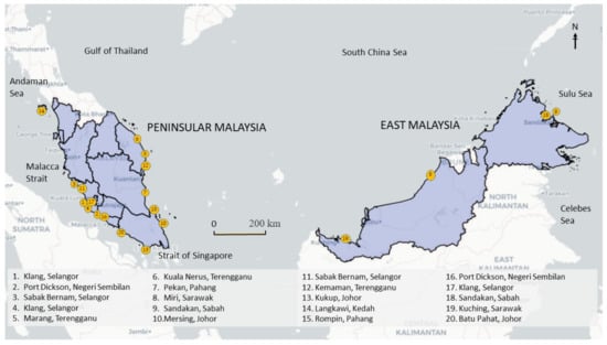
Figure 1.
Study areas along the shoreline of Peninsular (PM) and East Malaysia (EM).
Malaysia’s total shoreline length is 8840 km, of which the coastline of PM is 3771.5 km and EM is significantly longer at 5068.5 km []. The coast is mostly comprising easily eroded alluvium, approximately half of the shoreline is sandy and slightly less is the muddy coast, and very few rocky beaches. Sandy shores are found dominant along with east PM, west EM, and some parts of west PM []. In contrast, the coast of silt, mud, and clay are more distributed at the west coast of PM and north and east EM shoreline. Physical natural phenomena associated particularly with waves, currents, tides, and winds greatly influenced coastal zones’ dynamic process, especially during monsoon seasons.
1.2. Coastal Climate
Malaysia is geographically blessed and generally protected from severe natural disasters such as earthquakes, tsunami, volcanic eruptions, and typhoons, however, it is prone to major flood problems. There are two distinctive types of floods in Malaysia: flash and monsoonal floods. Flash flood often occurs due to heavy rainfall associated with severe thunderstorm by a timescale of fewer than six hours. Whereas monsoonal flood events are induced by prolonged heavy widespread rain that leads to land inundation. The annual average rainfall for PM is 2420 mm and over 2600 mm for EM []. The climate is categorized as tropical, being hot and humid throughout the year. Humidity is high and ranges from 80 to 90% with an average temperature between 21 and 30 °C []. Malaysia experiences insignificant annual variation in sea-surface temperature as the country is located near the equator.
1.2.1. Winds
Air pressure and wind behavior are greatly influenced by seasonal changes; Northeast Monsoon (NEM), Southwest Monsoon (SWM), and Inter Monsoons (IM). NEM begins from November to March during winter in the northern hemisphere dominating the lower troposphere synoptic circulation. During this period, the prevailing north-easterly wind speed is 10–20 knots, reaching up to 30 knots in some areas. In contrast, SWM is between June and September with the average southwest wind at 15 knots. The IM occurs twice a year during April–May and September–October with fluctuating wind direction not exceeding 10 knots [].
PM’s east coastal regions, which face the South China Sea, receive about 50% of its annual total rainfall during the first half of the NEM season between November and December []. During the transition periods, substantial rainfall occurs in April and October within the monsoon seasons []. While during the SWM, the south-westerly winds blow along the Indian Ocean and across the Andaman Sea []. The southwest monsoon in Malaysia is characterized by low precipitation, less cloud, high outgoing long-wave radiation, and often featured by dry epochs [].
1.2.2. Tides
Tides are among the main phenomena that regulate the interactions between coast and sea. Tides are periodic average sea level’s raising and lowering, caused by gravitational interactions between the sun, moon, and rotation of the Earth, occurred throughout the ocean []. There are three main types of tide phenomena, namely diurnal, semidiurnal, and mixed tides. Diurnal tides have one high tide and one low tide every day, while semidiurnal have two high tides every day []. The mixed tide is the combination of semidiurnal and diurnal tides, where significant different heights of successive high tides or low tides occur throughout the cycle [].
PM is dominated by semidiurnal and mixed (dominant semidiurnal) tides. Diurnal tides are dominant along the east coast of the states of Kelantan, Terengganu, Pahang, and Johor []. Whereas two types of tides characterize the west coast states of Kedah, Perak, Penang, and Selangor: semidiurnal and mixed tide prevailing semidiurnal []. On the other hand, both diurnal and semidiurnal tides dominate almost equally in Sabah and Sarawak’s coastal EM. There is no diurnal tide available in Malaysia. Based on tidal station records, the highest tidal range points are in Port Klang, PM, and Sejingkat, EM [].
1.2.3. Wave
Waves are among the most vital and dynamic forces behind the shaping of coastlines. The climate condition of Malaysian’s sea is considered low, where significant wave height is between 0.5 and 1.5 m with peak periods between 5 and 7 s []. The west coast of PM, Malacca Strait, expresses a low wave energy regime because of the Sumatera protection. While the east coast that faces the South China Sea, specifically Terengganu, experienced high wave energy during NEM []. Wave heights are more substantial with an effect on the larger wind fetch and greater wind speed. Wave energy intensity fluctuates seasonally with the highest energy density recorded during this season [].
1.2.4. Nearshore Current
Nearshore currents are principally induced by the impact of surface waves breaking on the beach. During the breaking process, wave energy is reduced and lost to turbulence as the wave hits the beach. The momentum of the wave is transferred into the water column and thus generates nearshore currents []. On the east coast of PM, notably in the states of Kelantan, Terengganu, and Pahang, the circulation of the current is greatly influenced by the monsoon winds. Particularly in Terengganu, coastal currents naturally flow parallel to the coastline as presented by []. The current flows northward during the SWM and southward during the NEM.
On the west coast of PM, the current flow pattern in Malacca Strait is dominated by tidal forcing []. Within the central region offshore Selangor, the dominant direction is 125° from the northwest to the southeast direction []. During SWM, the dominant wind speed and direction are within the range 5–25 m/s and 120–150°, respectively. Sediment transport within the region is generally induced by the longshore and cross-shore transport caused by wave and tidal current, greatly influencing erosion and accretion patterns [].
1.3. Socioeconomic Along the Coastline
Malaysia’s total population was 32.7 million, of which approximately 26 million populate Peninsular Malaysia, with an annual per-capita GDP of 12,478 USD in 2019 []. Among the major populations in PM, the largest ethnic group are Malays with 63% of the population, followed by Chinese, Indians, and other minority ethnic groups []. The country is ranked among the rapidly developing economies and is expected to become a developed world member. Along with economic development, health indicators have also considerably improved over the past few decades. Moreover, in 2018, life expectancy at birth in Malaysia has increased from 59.5 years in 1960 to 76 years [].
The National Coastal Zone Physical Plan 2012 (NCZPP) stated that there was 6.65 million population in PM’s coastal areas, representing 30.6% of the total population in PM in 2009 []. However, these numbers indicated an urgent increase over the past 18 years and revealed that the population placement is centered within the coastal areas. Thus, development within the coastal area will be more focused and may decrease the coast’s stability and security.
The states of Selangor, Federal Territory of Kuala Lumpur, Melaka, Negeri Sembilan, Perak, Johor, and Pulau Pinang are categorized as more developed states. However, Kelantan, Pahang, Kedah, Perlis, Terengganu, Sabah, and Sarawak are recognized as less developed states []. The high ratio of employment in coastal zones are in the states of Selangor (0.39%), Johor (0.37%), and Pulau Pinang (0.3%), where the areas are essential for employment, business, and residence []. The employed person in Malaysia reported a negligible decline of 0.3% month-on-month to 14.89 million persons. The number of the labor force increased marginally by 1.8 thousand persons, as against April 2020, to show 15.71 million persons []. Furthermore, the life quality in Malaysian society changed over the period of 2000–2018 through better access to education, healthcare, housing, and other infrastructures.
The agriculture sector supplied 7.1% of the total gross domestic product in Malaysia, with RM101.5 billion to the gross domestic product (GDP) in 2019 []. In Malaysia, oil palm was the primary contributor to the GDP of the agriculture sector in 2019 at 37.7%, followed by other agriculture (25.9%), livestock (15.3%), fishing (12.0%), forestry and logging (6.3%), and rubber (3.0%). In 2019, total marine fish landings were 1455.4 thousand tonnes, which rose by 0.2% against 1452.9 thousand tonnes in 2018. The production of freshwater aquaculture and brackish water also showed an increase of 3.3 thousand tonnes (3.3%) and 17.0 thousand tons (5.9%), respectively. The impact of agricultural development on beach dynamics is particularly significant as it contributes to sedimentation and nutrient runoff along the river towards the coastal area.
Presently, there are seven (7) major federal ports; namely Port Klang, Johor Port, Kuantan Port, Penang Port, Port of Tanjung Pelepas, Bintulu Port, and Kemaman Port, in which sea freight accounted for more than 90% of the total cargo volume in the country. The ports also provide boat or ferry services travelling around the country, connecting the mainland to the island and island to island. Moreover, Malaysia’s government spent large amounts of funds, particularly in the development of rails such as light rail transit (LRT), monorail, and Keretapi Tanah Melayu (KTM), to minimize the problems of traffic congestion in urban areas especially in Kuala Lumpur and Klang Valley. At the same time, this effort is to encourage the citizen to use railway service as a preferred mode of public transportation []. This connection is also particularly important as to link between the ports to further inland for economic purposes. Moreover, there are also several international airports located within the coastal zones of the country. In term of air freight, Kuala Lumpur International Airport (KLIA) is the main international airport and is one of the biggest airports in Southeast Asia [].
Based on the report by [], socioeconomy activities along the shoreline are highly dependent on coastal and marine resources. There are about 200 marine protected areas recorded where more than half are mangrove reserves. The reserves are set up under the Convention on Wetlands and comprise wildlife and bird sanctuaries, marine parks, fisheries protected area, and mangrove forests. The coral reefs areas are estimated at 3600 km2, most are found on the eastern coast and islands of PM, and also in Sabah and Sarawak. Coastal peat swamps and melaleuca forests were extensively vegetated along the west coast of PM. However, many of the lands have been converted to other economic uses such as agriculture, aquaculture, and industries. Malaysia had the fifth-most extensive mangrove areas globally [], which could be found intermittently along the coastlines. However, reported by [], they estimate that the mangrove areas is equivalent to only 1.75% of the country’s total land area at 575,000 ha. Other than climate change and environmental threats, marine resources in Malaysia are also subjected to issues related to coastal fisheries’ decline, threatened flora and fauna species, habitat destruction, poor marine water quality, and invasive species introduction through ballast water.
2. Coastal Management Strategies
The earliest study by the Intergovernmental Panel on Climate Change (IPCC): Coastal Management Subgroup and Response Strategies Working Group proposed three approaches for adaptation to sea-level rise, namely protection, retreat, and accommodation []. Discussions on available methods evolved and based on a recent management guide for disaster risk reduction in the European coastal zone, five different strategies are adopted [,]. In terms of coastal risk management in Malaysia, these options can be suited for both coastal erosion defense and sea-level rise adaptation. Figure 2 proposes six management strategies, which were also adopted from various studies by [,,].
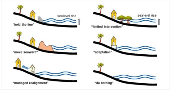
Figure 2.
Classification of adopted coastal management strategies as modified from [].
“Move seaward” is only carried out if coastal land reclamation is critically required, as the strategy leads to various adverse impacts on the environment. Adjacent ecosystems, wetlands, salt marshes, and mangroves are becoming more vulnerable due to coastal squeeze effects. “Hold the line strategy” maintains the existing shoreline due to significant land use, infrastructures, and socioeconomic activities within the coastal zone.
“Managed realignment” involves the relocation of critical structures or land use to further inland. The first two strategies are generally costly due to the construction of hard structures, such as seawall, revetment, breakwater, and a combination of soft engineering beach nourishment techniques. Whereas, the major cost in “managed realignment” consists of land purchase, rebuilding infrastructure, and relocation of existing businesses.
“Limited intervention” requires low or potentially no cost, such as changing existing land use, restoration of wetland, and mangrove replanting. The “Adaptation or accommodate’ strategy is the continuous usage of land at risk with no attempt to prevent the land from damage such as raising the platform level and elevated buildings. “Do nothing” is no active intervention, vacant land, or available wetland that has insignificant physical and economic impacts that are selected as sacrificial areas for inundation or erosion downdrift impact areas. Coastal defense strategy for protection from threats of erosion and sea-level rise is simplified in Table 1.

Table 1.
General comparison of coastal structures modified from []. ‘Reproduced with permission from The manage-ment of coastal erosion [], 2018; published by Elsevier, License Number 5071160448480, Date 17 May 2021’.
The selection of the coastal protection system is site-specific. For shoreline control, hard structures such as seawalls and revetment are the most effective, fast, and easy. Perpendicular structures such as groynes and breakwater promote natural sediment deposition and beach build-up. However, downdrift erosion is expected. Soft engineering techniques are ecologically friendly but are costly and require a longer time for significant impacts.
3. Coastal Erosion
The National Coastal Erosion Study in 2015 showed that 1348 km from a total of 8840 km or 15% of the shoreline is currently facing erosion problems under three categorizations: critical, significant, and acceptable erosions []. In this study, the demarcation of the coastline is between 0.2 and 1 km upstream of river mouths. For the past 30 years, protection works and shoreline management plans have been implemented; hence, the impacts of erosion are controlled even though they still occur primarily during the monsoon seasons. As compared to the earliest study, the National Coastal Erosion Study 1985 stated that 29% of 4809 km (not including islands) coastline was eroded under similar categories []. In the updated NCES 2015, improvements were made towards the descriptions, methods, and techniques in classifying erosion categories, with inclusions of scoring for physical and economic scores. In addition, recommendations on coastal management and mitigation measures were also included.
Based on the NCES 2015, Category 1 or critical erosion is a fast retreating coastline at the rate of more than 4 m/year with generally dense human settlement, some commercial/industrial activities being served by significant public infrastructure and facilities. Significantly eroded or Category 2 is the retreating shoreline at the rate of more than 1 m/year but less than 4 m/year. The area is generally sparsely populated or some agricultural activities are being served by relatively minor public infrastructure and facilities. Whereas, Category 3 is considered acceptable erosion; a slowly retreating coastline of less than 1 m/year with generally no human settlement and minimal agricultural activities not served by public infrastructure and facilities.
Information on eroded sites along the shoreline of Malaysia under the different categorizations is presented in Table 2. Statistically, out of the total eroded length, critical erosion was 4%, followed by significant erosion at 28% and the remaining 68% was acceptable erosion. The aggregate length of erosion under Category 1 and Category 2 was approximately one-third of the total eroded shoreline at 431.3 km. Typical mitigation measures for Category 1 and Category 2 erosions consist of hard structure construction such as revetment, breakwater, seawalls, and similar defense structures that are carried out quickly to avoid disastrous consequences. The proposed mitigation measures of the identified site should be technically feasible, economically viable, environmentally friendly, and socially acceptable.
Table 2.
Coastline erosion condition in 2015 as reported by []. ‘Reproduced from Report on National Coastal Erosion Study, 2015; published by Department of Drainage and Irrigation, Malaysia’.
Moreover, NCES 2015 also recommended a two-pronged approach: curative action and a preventative strategy. The first approach refers to the immediate coastal protection works along with the critically eroding coastal sites. The latter focuses on administrative instruments and development control plans to pre-empt potential erosion problems due to coastal development. Some case studies on available coastal protection structures as curative methods at selected eroded sites are briefly discussed.
3.1. Hard Structures
Hard structures are frequently used in the “hold the line” strategy as they provide a quick solution at the eroded beach. However, they commonly cause erosion at down drift, hence a sacrificial area or vacant land should be provided. The wave impact is higher at impervious structures, such as solid seawall, leading to a higher rate of overtopping and scouring problems at the toe than permeable rock revetment and armor rock structures. Therefore, a sufficient apron as toe protection is commonly required to avoid structural failure.
3.1.1. Seawall and Rock Revetment
Seawalls and rock revetment are considered the most popular, most effective, and quickest solutions for shoreline erosion control, yet are the most expensive and can potentially cause adverse impacts on the surrounding coastal environment (Figure 3). Abdullah et al. [] evaluated the community’s perception and effectiveness of protecting rock revetment at Pantai Jeram and Pantai Remis, Selangor, Malaysia. It was recorded that the beaches increased in width after eight years of implementation, however, the destruction of mangrove forests was observed. It was due to deforestation of the mangrove [] and low awareness amongst the coastline community.
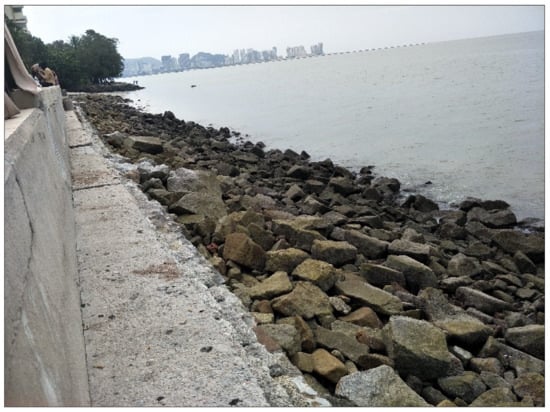
Figure 3.
Non-accessible and less aesthetical tourist beaches due to hard structures.
Rock revetment is designed as less permeable seawalls with a sloping mount and is constructed of large boulders interlocked together to dissipate wave energy. Both seawall and rock revetment have undeniably affected the natural coastal landscape scenery and tourists cannot easily reach the seawater, resulting in the reduction of visitors and income to the residents [].
Rashidi et al. [] developed an innovative porous seawall structure and installed it approximately 100 m long at Port Dickson, Negeri Sembilan. The structure measured 1.2 m × 1.2 m × 1.2 m with a face angle of 45°, made of reinforced concrete, and weighs 2500 kg/unit. As shown in Figure 4, hollow sections on the surface allow sediment movement from the front to the rear area of the structure. It encourages the natural reclamation of sediment and beach expansion after a certain period. Coastal morphology change in the eroded beach was due to the intervention of man-made structures, namely the marina and pipe outfall, which affects the natural sediment process. This “hold the line” structure successfully protected the area from further inland erosion but faced a severe scour problem. A continuous erosion scenario occurred, especially during high wave events due to a lack of natural sediment supply. However, accretion was found close to the constructed marina further south. Eroded sediments at the structural installation area were transported and accumulated at the adjacent shoreline: a classic example of a hard structure impact scenario.
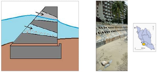
Figure 4.
Innovative porous concrete seawall developed in Port Dickson by [].
3.1.2. Breakwater and Perpendicular Groyne
In general, the types of breakwater is closely related to the sloping mount [] and relative to seawater depth [], which can be classified as detached, headland, nearshore, attached, emerged, floating, and submerged breakwaters. These structures were built close to the coasts as part of the coastal defense and an anchorage from the effects of monsoon, tide, and longshore drift. Additionally, it is usually built to provide calm from energetic ocean waves for harbors and artificial marinas.
Over time, it dramatically reduces wave action through reflection, the dissipation of incoming wave energy, changes of beach profile, and, finally, sand accumulation within a breakwater []. The construction of breakwater requires millions of dollars, for that reason, feasibility studies, including a detailed hydrographic survey, engineering design, seabed geotechnical investigation, wave height evaluation, and material needs assessments, are required. The optimum cross-sectional design of the breakwater is a crucial factor that needs to be considered to minimize significant problems such as beach erosion and sediment scour, which commonly led to dramatic foundation destabilization []. Installation of the combined breakwater with a perpendicular groyne has provided additional stabilization features as sediments accumulated, thus, expanding the beach as such in Pantai Cahaya Bulan, Kelantan, and Pantai Paka, Terengganu. In addition, there is an existing adaptation of the groyne protection structure done by the local community near Cherating Beach.
The emerged breakwater could be either attached or offshore breakwater. An attached breakwater is commonly constructed at the river mouth and is attached to the land, to protect against wave impacts and for navigational purposes. Whereas, the offshore or detached breakwater is solely for wave protection. The detached breakwater is a structure built offshore with its crest above the higher sea level (HSL), mean sea level (MSL), and lower sea level (LSL). This type of breakwater is amongst the famous structures examined in Malaysia. Simply emerged breakwaters have been constructed at Sungai Haji Dorani Beach, near Sabak Bernam, Selangor, Malaysia []. The breakwaters are divided into three different parts with a nominal length of 27 m that are separated by 5 m gaps to reduce water circulation and consequently adverse ecological effects, as shown in Figure 5. The crest heights of the structures varied from 1.5 to 1.7 m. The crest level was measured at an average of 1.80 m above MSL and relatively placed between 5 and 60 m from the shoreline, which improved the sediment deposit behind the structure. However, the Sg Hj Dorani beach is predominantly covered by a very low shear strength of soft mud (22% clay (<2 mm), 56% silt, 17% fine sand, and 5% organic matter), which made the construction process very difficult, impractical, and costly. The total cost of this project was USD 85,000. It was reported that moderate restoration of mangrove approximately 30% of the original sampling survived, however, a substantial volume of sediment was retained on the beach in a short period, demonstrating the efficiency of the coastal structure in raising the beach elevation.
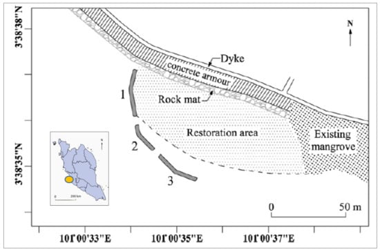
Figure 5.
Emerged breakwater beach restoration in Sg Haji Dorani []. ‘Reprinted with permission from An integrated approach to coastal rehabilitation: Mangrove restoration in Sungai Haji Dorani, Malaysia, 2010; published by Elsevier’.
Kamali et al. [] suggested that the mudflat shore along the west coast of PM is mostly protected by a combination of rock bunds and breakwater for protection from erosion during high tide events to overcome this issue. For example, the coast of Morib, Kuala Langat, Selangor incorporates hard structure and soft engineering techniques, which comprise earth bund as major protection and geotextile tubes to provide a suitable environment for mangrove replanting. The sheltered area provides calmer hydrodynamic conditions and augments sediment deposition suitable for mangrove replanting. This natural “limited intervention” strategy in preserving mangrove forests effectively reduces wave impact [].
Field demonstration tests at Pulau Carey, Selangor, Malaysia have also been conducted by Fitri et al. []. This 85 m-long stretch detached low-crested breakwater with three circulation gaps (5 m) was built in early 2009, as shown in Figure 6. It was mentioned that the sediment traps were slightly higher during the SWM than in the NEM due to calmer hydrodynamic conditions. In addition, an average increment of 4 cm in the coastline profile elevation, which was measured at the landward area near the structures after a year of construction, has potentially improved the mangrove rehabilitation in this area.
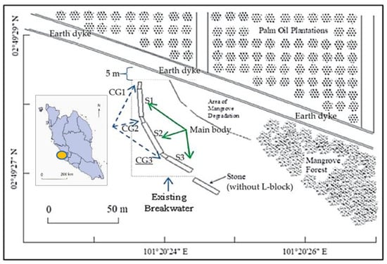
Figure 6.
Low crested breakwater for sediment trap in Pulau Carey []. ‘Reprinted from Dynamics of sediment transport and erosion-deposition patterns in the locality of a detached low-crested breakwater on a cohesive coast, 2019; open access publication by MDPI Water’.
Furthermore, an empirical study of shoreline evolution on a 30-km stretch of the Kuala Terengganu coastline, related to beach profiles and coastal hydrodynamics was carried out by Ariffin et al. []. Figure 7 shows the man-made structures and breakwaters along the Kuala Terengganu coastlines. In the years 2012–2014, high erosion rates were observed in Zone A, accretion in Zone B, and stable conditions in the southern part (Zone C). In Zone A, strong waves and currents during NEM caused structural degradation and moved the erosion to an area just north of the revetment. Airport tarmac extension also affected the process of wave refraction and diffraction and shoaling, resulting in erosion at the up-drift area. However, extensive accretion with an average of +9.03 m/year (total +26.48 m) was recorded in Zone B at the southern airport tarmac extension, due to the effect of the downdrift side. The construction of groynes, artificial structures, and detached breakwaters along the eroding coast had successfully protected the eroded shore. However, their placement may have blocked longshore sediment transport, thus interrupting the natural hydrodynamic process and shoreline evolution.
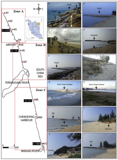
Figure 7.
Coastal protection structures along Kuala Terengganu—Marang beach. (Erosion at locations in subfigure a–g, i and j; accretion at subfigure g, h and l; no changes at subfigure e and k []. ‘Reprinted with permission from [], 2018; Elsevier. License Number 5071150332416, Date 17 May 2021’.
A similar work was also reported by Ariffin et al. [] at Tok Jembal, Kuala Terengganu, Malaysia. Figure 8 shows the accretion and erosion rate changes between 2013 and 2017 at Tok Jembal, Terengganu. Sediment accretion of positive 8 m was measured at the area behind the jetty-type breakwater at Tok Jembal. However, a negative charge of erosion at a maximum rate of −20 m was recorded along the exposed beach. Further north at the UMT beach, the coast experienced some erosion and accretion events. The construction of the groyne structure played a significant role in protecting the area from storms during NEM. In SWM and IM, sand tombolo was developed at the lee-side and promoted a minimum of +30 m sand accretion at the southern part of the UMT coast. The design of groyne structure with extended structure towards the sea caused sediment accretion at only one side of the structure, while the adjacent side demonstrated erosion. Pantai Marang, Terengganu is a natural long sandy beach that only erodes during the NEM. Similar work was also conducted in this region by using armor rocks placed along the eroded shoreline as a temporary defense []. This structure was installed and found successful as erosion control. Sediments were also recorded to accumulate within the structure during calmer months; hence, encouraging seasonal coastal vegetation growth.
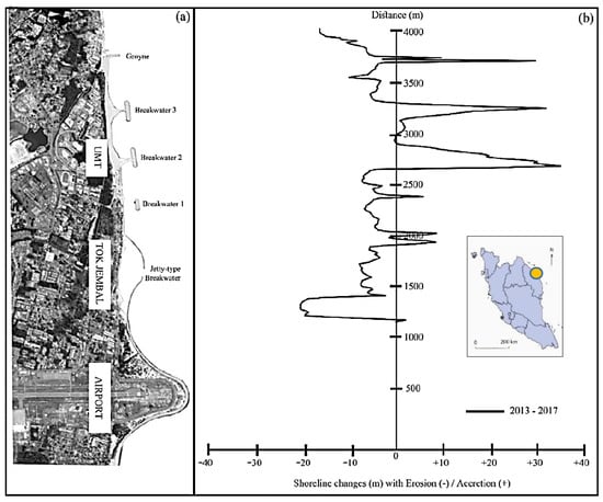
Figure 8.
Shoreline changes along Kuala Nerus beach with (a) the current shoreline in 2017 and (b) erosion and accretion rates between 2013 and 2017 []. ‘Reproduced from [] 2020; JSSM UMT.’
The coastal zone of Pahang plays an important role in its population as it is the centre of social, environmental, and economic activities. However, approximately 125.4 km or 46.3% of the total Pahang shoreline is currently eroded []. To assess the profound impact of the shoreline, Mohd et al. [] conducted a coastal vulnerability index (CVI) study at parts of the Pahang coast, from Cherating to Kuala Pahang as presented in Figure 9. It was suggested that the vulnerable shorelines were reduced from erosion to some extent due to the installation of coastal hazards such as sandbags and breakwater. This was particularly at the north of Pahang including: Pantai Cherating, Jeti Gebeng, Taman Gelora, and Kelab Golf di Raja Pahang. However, the expansion of Kuantan ports affected sediment transport dynamic and, hence, contributed to erosion. Based on the numerical simulation in this study, with a projection of 0.31 m water level increase in 2100, the expected area of inundation is 1041 ha. The proposed “adaptation” and “hold the line” strategies include increasing the height level of rock revetment and installation of breakwater structures [].
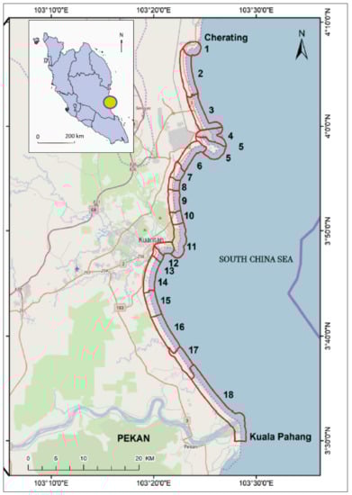
Figure 9.
Coastal vulnerability impact (CVI) assessment along the Cherating–Pekan coast []. ‘Reprinted with permission from Comprehensive coastal vulnerability assessment and adaptation for Cherating—Pekan coast, Pahang, Malaysia [], 2019; published by Elsevier, License Number 5071141176280, Date 17 May 2021’.
The coastal line of Miri, Sarawak is facing stresses and changes in climatic condition due to urbanization and petrochemical industrial development. Various environmental problems, such as coastal erosion, sediment accretion, and water pollution, were recorded within the study area. The two river mouths of Baram Miri Rivers vitally influence the dynamic environment, especially at the northeast zone of Miri’s shoreline. Anand Kumar et al. [] used satellite imaging technology and geographical information systems (GISs) to evaluate the shoreline and coastal morphological changes from 1963 to 2014. It was measured that within 51 years, 723 acres of shoreline were accreted, while erosion occurred at 547 acres of shoreline area. Figure 10 shows the major changes in approximately 74 km of a coastal belt from the Baram River mouth (Kuala Baram) to Bungai Beach. It was concluded that sediments discharge from Baram River reduced the depth of the delta area. Therefore, frequent dredging activities were carried out by port authorities to remove accumulated sediments for navigational purposes. However, over dredging had caused erosion at the Kuala Baram River mouth, along with the construction of beach structures for coastal development. To minimize the impact, breakwater structures were built along the Miri River mouth, Esplanade, and Tanjong Lubang beaches to increase beach accretion. Coastal management board authority plays a vital role in planning sustainable development and environmental protection and encouraging public awareness to reduce the impact of coastal erosion [,].
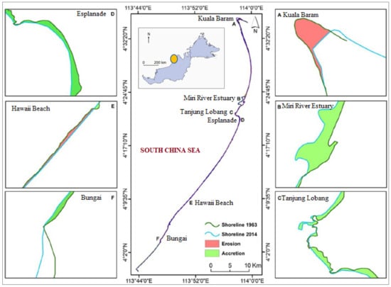
Figure 10.
Shoreline changes between 1963 and 2014 in Miri, Sarawak (A. Baram River Estuary, B. Miri River Estuary, C. Tanjong Lobang Beach, D. Esplanade beach, E. Hawaii beach and F. Bungai Beach) []. ‘Reprinted with permission from [], 2019; Elsevier. License Number 5071150332416, Date 17 May 2021’.
3.1.3. Porous Submerged Breakwater
The porous submerge structure is also amongst the famous techniques to be implemented as a coastal protection approach due to the negative response from the public against hard structures, such as armor rocks, geo tubes, revetments, and seawalls. Submerged breakwaters, underwater dykes, and artificial reefs are amongst the widely used. Fatimah et al. [] fabricated an artificial mangrove root system as an alternative solution to overcome coastal erosion in cohesive soil coastlines. It was verified that the numerical simulation and experimental results on the wave transmission coefficients showed in close agreement. Here, the artificial structure was more effective in reducing wave energy at a ratio of structure height (ds) and water depth (d) was larger than 1 (ds/d > 1.0).
Another example, reef ball structures were deployed by Sabah Park as a state government agency in 2005 at Selingan Island, Sandakan, Sabah, Malaysia. The 290 sets of this submerged structure that protects the shoreline were arranged into three rows at the southern part of the island to increase the stability as shown in Figure 11 As can be seen, the size of Selingan Island has slightly decreased from 9.56 to 8.56 hectares from 2010 to 2016. The east and west mid-sides of the shoreline were eroded, however, the southern tip island experienced sand deposition between the reef balls and stone revetment. It can be suggested that the presence of reef balls as coastline protection successfully increased the sand deposition processes due to the reduction of attenuation waves and local current speed []. Saleh et al. [] also mentioned that the installation of reef balls improved the formation of the tombolo, trapping the sediment and providing more nesting areas for turtles.
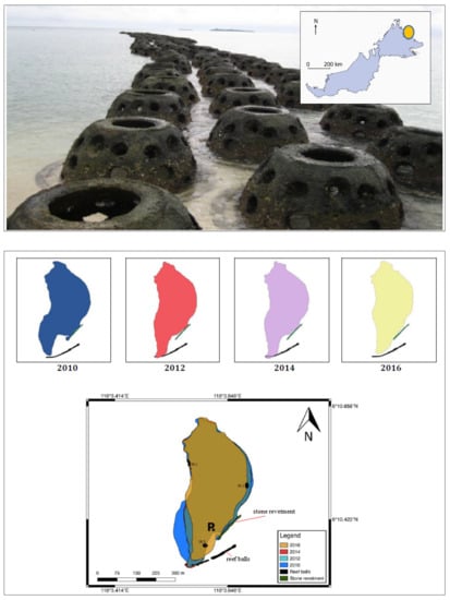
Figure 11.
Innovative reefball structure and shoreline changes in Pulau Selingan []. ‘Reprinted from Effect of artificial structures on shoreline profile of Selingan Island, Sandakan, Sabah, Malaysia, 2018; open access publication by BJoMSA UMS’.
Novel prefabricated concrete structures that were stacked together to form a simple trapezoidal arrangement as a single unit, as shown in Figure 12, were studied by Desa et al. []. This submerged structure was installed approximately 150 m from the shoreline of Pulau Tinggi, Johor, Malaysia. The experimental result indicated structural friction to wave motion, where the coefficient of transmission Ct values tend to decrease with the increment value of relative wave period, incident wave height, and relative narrow crest width []. The function of this structure is for wave breaking protection [] with additional functions to restore the coral growth and fish ecosystem. The prototype weighed 371.38 kg with a density of 2400 kg/m3, which resulted in high cost during transportation and installation. After three years of deployment, the coral reef colony rapidly grew from 8.66% to 29.75% from the whole surface of the structure [].
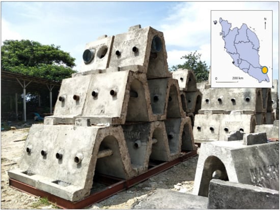
Figure 12.
WABCORE as a wave breaker and artificial reef structure
3.1.4. Geotextile-Tube Protection
A study on geotextile tubes as coastline protection was conducted by Sulaiman et al. []. Four geotextile tubes were used with a dimension of 1.8 m (h) × 3.7 m (w) × 50 m (L), stretching 200 m and hydraulically filled with slurry sand. These breakwaters were placed at approximately 70 m from the coastline of Muara Marine Park Resort in Sungai Haji Dorani, Sungai Besar, Selangor as shown in Figure 13. Three different species of mangrove seedlings, namely Rhizophora apiculate, R. mucronata, and Avicennia alba, were planted by using three innovative planting techniques. It showed that only Rhizophora apiculate and R. mucronata species had the highest survival rate of more than 90%. However, after five years, only 34% of the 8857 planted mangroves survived. It was due to a strong current, high waves, and soft mudflat, which resulted in sweeping and uprooting of the seedlings [].
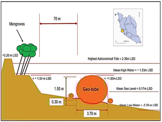
Figure 13.
Geotube as shoreline erosion control and mangrove rehabilitation []. ‘Reprinted from Establishment of Shoreline Buffer Zone through Rehabilitation of Degraded Coastal Mangroves, 2019; open access publication by MATEC Web Conference’.
The effect of several types of breakwaters was observed along the coastal zones of Terengganu, Malaysia. The application of geotextile-synthetic tubes for shoreline management constructed in Teluk Kalong and Pantai Batu Buruk, Terengganu was discussed by Lee et al. []. In this work, a 3.5 m diameter polypropylene woven fabric with an effective pore size of less than 180 µm to retain the watery sand in-fill was used. These breakwaters were placed at a total length of 500 m, approximately 150 m from the offshore. They were fully submerged throughout the tidal cycle and had 1 m freeboards during the low tide condition. A post-installation bathymetry survey was obtained and resulted in the sand accretion on the foreshore area with a thickness exceeding 1.8 m at Teluk Kalong, Terengganu, as illustrated in Figure 14. Wave energy impact was reduced and shallower water depth was measured at the foreshore area, minimizing the potential of further erosion along the shoreline.
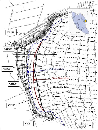
Figure 14.
Geotube as submerged dykes in Teluk Kalong, Terangganu []. ‘Reproduced with permission from Geotextile tubes as submerged dykes for shoreline management in Malaysia [], 2012; published by Elsevier, License Number 5071151338498, Date 17 May 2021’.
Johor is a state in the southern region of Peninsular Malaysia that has an effect of hydrodynamics forces, sediment supply, geomorphology, and antecedent topography with close relations with current and wave from Malacca and Singapore Straits. Tanjung Piai beach, Johor is located at the most southern tip of Asia is classified under Category 1 coastal erosion, where mangrove forest is critically eroded. The muddy coast is also facing oil spill incidents, which caused degradation of mangrove and eventually increased the erosion process. Protection structures, such as geotextile tubes, sea wall, revetment, and offshore breakwater, are implemented in phases []. Geotubes of over 1.5 km long with the cost of USD 0.7 million were built between 2003 and 2006 along the Tanjung Piai beach. However, due to the soft soil at the seafloor, the structure sank into the mudflat and lost its capability to protect the coast. It was also observed that offshore breakwaters have successfully safeguarded the mangrove forest from further deterioration. The structures led to sediment accumulation at the up-drift side and corresponding minor erosion on the downdrift side. The reduction of current speed and wave height behind the structures allowed calmer conditions for mangrove growth. Besides, the function of the geotextile tube as a breakwater to minimize the scouring effect at the toe and mud floor is forecasted to occur due to turbulence generated by wave energy reflection at Tanjung Piai, Johor. Tan et al. [] also observed that the breakwaters created a calmer water surface at the shoreward side. Figure 15 shows the schematic diagram and photo of the geotubes at Tanjung Piai Johor. It has obtained substrate build-up significantly close to the shoreline.
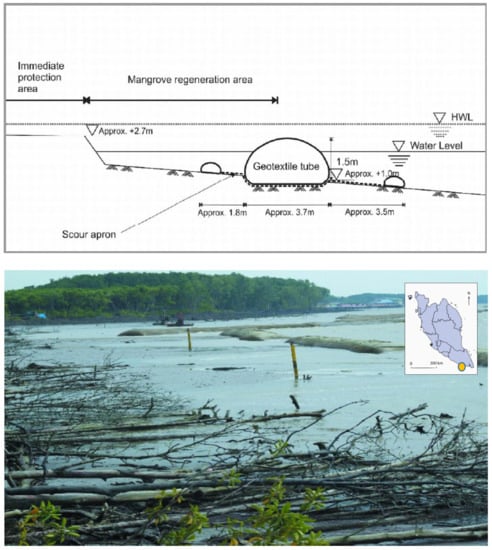
Figure 15.
Geotextile tube as mangrove forest erosion control in Tg Piai []. ‘Reprinted from Geotextile Tubes for Protection of Mangrove Coast in Malaysia, 2007; open access publication by UMP Repository’.
Hashim et al. (17) evaluated the distribution of mangrove forest at the mudflat coastline along with the three northern states of Peninsular Malaysia, which are Perak, Kedah, and Perlis. Besides serving as coastal protection, a geotextile tube is also used as a mangroves rehabilitation line on the muddy coast of Kuala Teriang, Langkawi, Kedah. This region was one of the most affected tsunami-hit areas in 2004. The geotextile tubes were laid as an additional line to protect the healthy mangrove forest that grows along the muddy coast of Sg Melaka and Sg Kuala Teriang (Figure 16). A 3 m diameter geotextile fabric tube installation was approximately 100 m (4 m × 50 m long) placed in front of the beach for secondary protection. The geotube project initiated by the state government has protected the coastline and encouraged sediment deposition []. Accumulated sediment successfully stabilized the shoreline and provided a suitable condition for natural mangrove growth [].
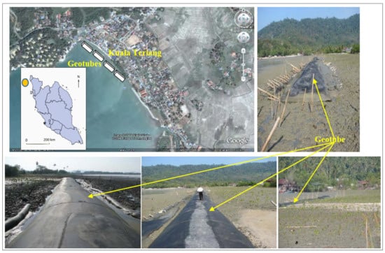
Figure 16.
Geotube protection for mangrove reforestation in Kuala Teriang []. ‘Reprinted from Mangrove Reforestation in Kuala Teriang area, Langkawi, 2008; open access publication by SEAFDEC Repository’.
3.2. Soft Engineering and Ecological Based Approach
Soft engineering is an approach of manipulating the natural ecosystem and implementing ecological practices rather than interrupting the process, which provides a less negative impact in the long run. The three main techniques of soft engineering include beach nourishment, beach reprofiling, and a living shoreline. Beach reprofiling offers maximum protective beach width and nourishments often require periodically long term maintenance. Whereas the living shoreline method commonly proposed together with coastal vegetation replanting. With regards to minimizing adverse environmental impacts and the negative response from the public against hard structures, a combination of both approaches was also suggested. This could be of seawalls and beach nourishment on sandy beaches or rock revetment and mangrove replanting on the muddy shoreline. Research and development on alternative materials are progressively being conducted in Malaysia to replace the mountainous boulder, natural rock, and concrete structure with more environmentally friendly innovative materials such as polymer seagrass, artificial reefs, and composite coastal block.
3.2.1. Beach Nourishment and Reprofiling
Since 1987, various methods to mitigate beach erosion have been implemented by the Department of Irrigation and Drainage (DID), Malaysia. Chong et al. [] reported that beach nourishment was one of the famous soft engineering approaches implemented along the Malaysian coast. From early 1990 to 1995, at least seven main beach nourishment projects were successfully deployed with a total cost of RM65.8 million. Seberang Perai, (Butterworth, Pulau Pinang,), Seberang Takir (Terengganu, Malaysia), Kuala Terengganu (Terengganu, Malaysia), Dungun (Terengganu, Malaysia), Pantai Kundur (Melaka, Malaysia), and Port Dickson (Negeri Sembilan, Malaysia) stretch a total of 22,250 km that was included in these projects. Further, Tan et al. [] used the pressure equalization modules (PEM) system to evaluate the accretion at Teluk Cempedak, Pahang, Malaysia. This PEM system was fabricated from 2.0 m (length) × 0.15 m (inside diameter) and 3 mm (thickness) of drainage PVC pipe. This vertical pipe was perforated with an arc slot at 90 mm × 0.2 mm (width) × 30 cm long horizontal slots with 10 cm distance between each section arranged vertically along the length of the pipe as shown in Figure 17. A beach nourishment process was initially done for the application of this system. After three years of implementation, the total sand volume and beach elevation were found significantly higher in PEM areas. The results concluded that the PEM system stimulated the natural sediment accretion, hence, decreasing the rate of erosion. The pattern of sand volume distribution showed that accretion of sand occurred in the northern area. In contrast, the southern part of the beach experienced erosion. This technique was successfully used in Denmark [], the Netherlands [,], and the USA [].
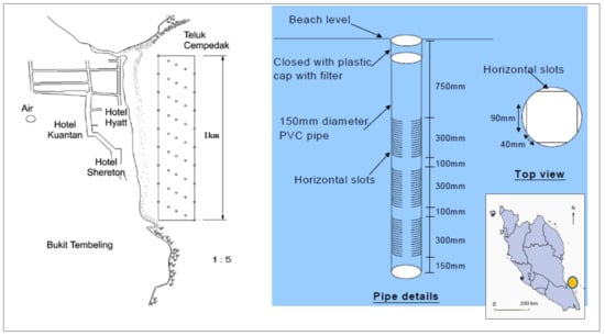
Figure 17.
Innovative PEM system as beach rehabilitation in Pulau Tioman []. ‘Reprinted from Rehabilitation of the Beach at Teluk Cempedak, Pahang, Using Pressure Equalisation Modules (PEM) System, 2009; open access publication by IEM Repository’.
The sandbag system was also implemented at the eroded beach of Port Dickson, Negeri Sembilan as a temporary defense measure. Figure 18 shows that the sandbags were destroyed due to the ageing process at Port Dickson []. However, as a tourist attraction area, beach nourishment was conducted recently, which requires maintenance every three to five years. This technique is considered a “hold the line” strategy to maintain the recreational beach []. The impact of land loss could be minimized by an in-depth understanding of coastal sediment supply and redistribution at specific vulnerable areas [].
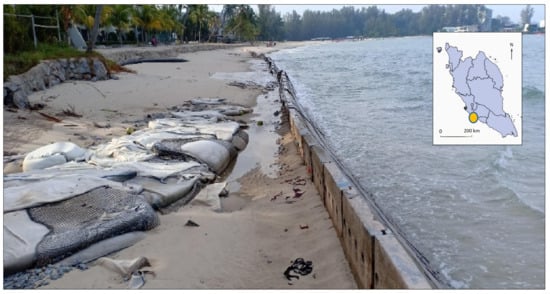
Figure 18.
Damaged geotextile-tube replaced with concreted structure protection [].
3.2.2. Mangrove Rehabilitation as a Natural Coastal Protection
In late-2004, an undersea megathrust earthquake in Northern Sumatra, Indonesia caused the Indian Ocean Tsunami of a 9.1–9.3 Richter scale magnitude. The impact caused severe damage to African and Asian countries, especially the western shoreline of Phuket, Thailand, and the island country of Sri Lanka []. It was noticed that villagers along the coastline were surrounded by extensive mangrove forests and, hence, were shielded from the impacts of the tsunami waves, as compared to the villages in the southwestern part of Sri Lanka and Southeastern India. Since then, many researchers in Malaysia have studied the effectiveness of mangrove forests and replanting them for coastal protection []. Post tsunami, most coastal vegetation was affected by the shedding of leaves or browning of canopies. However, mangroves were found to tolerate the tsunamic waves without showing any apparent damage. Therefore, mangroves are inarguably the most suitable vegetation species to minimize the effects of mighty tidal waves []. In addition, coastal vegetation grew healthily at the affected muddy beach as the uprush of tsunami seawater and sediment depositions have remineralized the land [].
Hashim et al. [] evaluated the performance of mangrove forests in different wave reductions using artificial Rhizophora tree models in a narrow wave flume. The experiments showed that the wave height in an area with both tandem and staggered mangrove arrangements was approximately two times lower than that in bare land. Mullarney et al. [] stated that the wave height reduced due to drag coefficients at the largest and densest pneumatophore canopies of the mangrove fringe was observed. Human population growth significantly influences mangrove deforestation [] and degradation []. For example, in the late 60s, Indonesia lost more than 200,000 ha of its mangroves plants mostly in Java and Sumatra, resulting from the encouragement of government policies to boost timber production, shrimp farm agriculture, and palm oil plantation [,,]. Similarly, the mangroves ecosystem in Malaysia, especially at the Johor coastline is changing due to the increasing demand and developments in agriculture, aquaculture, and urbanization [,]. Although these developments are to improve the socioeconomic conditions of the local communities, they negatively affect the mangrove forest population. Since 2005, several huge areas of degraded coastlines have been replanted and protected for conserving the mangrove ecosystems biodiversity with associated species, for example, the Matang Mangrove Forest Reserve (MMFR), Perak, Malaysia [,,]. Goessens et al. [] stated that the MMFR program was recognized by UNESCO and is still considered as the most well-balanced mangrove forest preservation program in the world. In general, a maximum stem diameter of 30 cm of the mangrove species yield has been observed. However, loss of trees due to exploitation as biomass was also observed. There is an increasing focus in studies on the interactions between Malaysian mangrove ecosystems and tidal flooding associated with sea-level rise. Ye et al. [] studied the responses of K. candel and B. gymnorrhiza mangrove species to water level rise under the mesocosm experiment. It was ascribed that only K. candel seedlings showed high survival rates of over 90%. It was shown that acidity was more serious in fine mud than in coarse soil resulting from a sea-level rise and affected the survived seedlings. A new mangrove rehabilitation using an ecoengineering coastal protection technique to restore the endangered mangroves on Carey Island, Malaysia was studied by Motamedi et al. []. It was found that silt and clay content increased up to 76.14% and approximately 23.86% of fine sand. The result illustrated that increases in seabed elevation, nutrient composition, pH value, and salinity index are suitable in establishing mangrove growth after four years into the project.
4. Sea Level Rise
The first sea-level rise (SLR) study in Malaysia by NAHRIM collaborated with the California Hydrologic Research Laboratory (CHRL), the United States of America in 2010. The methodology in obtaining SLR rates was based on the atmosphere–ocean global climate model concerning Assessment Report No. 4, Intergovernmental Panel on Climate Change 2007 (AR4 IPCC) by using the linear trend analysis on the tide gauge and satellite altimeter []. The study showed that the national SLR projection was 2.5–10.6 mm/year, slightly higher than the global projection, with a maximum rate projected for Kedah, Kelantan, and Sabah.
An updated national sea-level rise study due to climate change impact was conducted by NAHRIM recently in 2017 with the collaboration of the Commonwealth Scientific and Industrial Research Organisation, Australia (CSIRO), and Universiti Kebangsaan Malaysia (UKM) []. The study was based on AR5 IPCC 2013 on various RCP (representative carbon pathway) scenarios by using the latest tide gauge data and satellite altimeter. The projections were derived from Coupled Model Inter-comparison Project Phase 5 (CMIP5) with the combination of data from global ocean thermal expansion, mass loss due to glaciers, the surface mass balance of ice sheets, land water storage change, and GIA-induced regional sea-level changes in surface loading over the previous glacial cycle []. Regarding the updated study [], the rate of sea-level increase and projection details in the year 2100 are given in Table 3 and Table 4, respectively. Figure 19 presents the map of SLR projection along the shoreline in Malaysia based on a similar RCP 8.5 scenario. A study using the radar altimeter database system (RADS) also suggested that land subsidence due to excessive water extraction also enhanced the impacts of sea-level rise on coastal cities [].
Table 3.
Historical average rate of sea level (mm/year) based on IPCC AR5 []. Reproduced from Report on Impact of Climate Change: Sea Level Rise Projection in Malaysia, 2017; published by National Water Research Institute of Malaysia.
Table 4.
Projection of sea-level rise in Malaysia for * RCP 8.5 in year 2100 []. Reproduced from Report on Impact of Climate Change: Sea Level Rise Projection in Malaysia, 2017; published by National Water Research Institute of Malaysia.
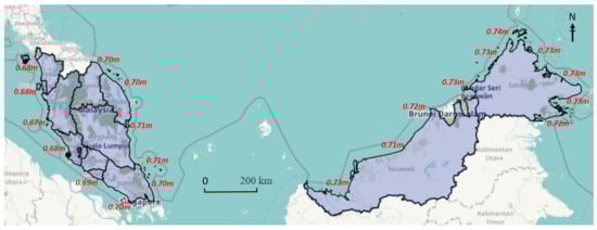
Figure 19.
Map of the sea-level rise projection of Malaysia in 2100 based on RCP 8.5 []. Reproduced from Report on Impact of Climate Change: Sea Level Rise Projection in Malaysia, 2017; published by National Water Research Institute of Malaysia.
A detailed study on the impact of sea-level rise was carried out by using DTM, GIS, and MIKE21 numerical software tools, conducted at several coastal cities in Malaysia to produce inundation models and vulnerability maps []. This section reviews the studies conducted from 2010 to 2018, where the previous AR4 IPCC was referred. The proposed adaptation measures to sea-level rise could also be a selection of hard structures or soft engineering approaches, incorporated with various approaches of the shoreline management strategy.
4.1. Adaptation with Increased Pillar
The study on sea-level rise at the shoreline of Klang, Selangor [] indicated that almost all existing village settlements at Pulau Ketam will be affected with an increase in the maximum water level rise of 0.53 m in 2100. Currently, some areas are already inundated by seawater, particularly during high tides. Therefore, local coastal communities have already implemented an “adaptation strategy”, raising the level of the water house pillar and jetty through their initiative (Figure 20). Local participation is considered the most important and key level for adaptation, as suggested by []. Increased platform and jetty levels are also found in commercial and industrial areas such as Port Klang and Langkawi Island to minimize physical impacts.
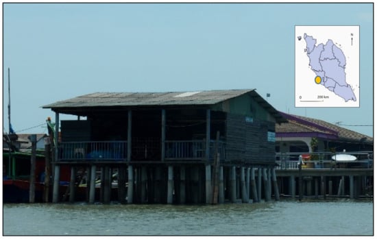
Figure 20.
Community adaptation with an increased level of the house pillar, Klang []. Reprinted from Impact of Sea Level Rise Due to Climate Change: Case Study of Klang and Kuala Langat Districts, 2018; open access publication by IJET database.
4.2. Structural Seawall, Bunds, and Mangrove
Hydrodynamic modeling simulations for the sea-level rise projection in 2020 and 2040 showed no significant change in Sandakan Town as compared to the existing condition, most likely due to the existing high-level platform []. Mostly, structural protection works are already included with certain analysis on the return period for engineering purposes. However, with an increase of 0.5 m of water level in 2060, a significant change in wave height and current is expected. Therefore, the proposed “adaptation” and “hold the line” strategies at the town area includes the raise of rock bunds and platform levels (Figure 21). These strategies are also found in commercial and heavy industrial areas, such as Port Klang, which is amongst the top 15 busiest port globally. Structural protective as “hold the line” and “adaptation” strategies such as raise the level of seawall, concrete bund, and rock revetment was proposed to minimize physical and socioeconomy impacts. At tropical estuaries that are more vulnerable to hydrodynamic and sedimentation rate change as discussed by [,], earth bunds are commonly constructed.
Figure 21.
Proposed raised seawall and coastal bunds Sandakan town []. Reprinted from. Sea Level Rise Impacts and Adaption Measures for Sandakan, 2014; open access publication by HENRY Repository.
4.3. Proposed Flood Gate and Tidal Barrier
Among other impacts of sea-level rise is saltwater intrusion. As the deltaic Rajang River, Sarawak is essential for agricultural and aquaculture activities, the vulnerable areas must be protected to maintain the existing socioeconomic activities for local livelihood. An increase of 0.72 m is projected by the end of the century, hence, salinity contour will intrude further up to 9 km into the river as the deltas are low lying area []. Seawater intrusion can be controlled by a river dam, floodgate, or tidal barrier as a ‘hold the line’ and ‘managed realignment’ strategy. However, they are costly and require a detailed study to minimize the impact (Figure 22) on the existing ecosystem.
Figure 22.
The tidal barrier to prevent seawater intrusion impact, Sarawak []. Reprinted from Saline Water Intrusion through Rajang River Network due to Sea Level Rise, 2019; open access publication by IOSR Journals.
4.4. Abandoned Coconut Plantation, Batu Pahat
A study by [] showed that the expected inundation in 2040 would affect 2.47% of the population, 21.21% of the road network, and 33.33% of mangrove forests in Batu Pahat, Johor. The increase of sea level in 2040 is projected at 0.066 m with up to a 1.8 m/s increase in current speed. The coast is predominantly muddy, reaching up to 1.5 km towards the sea during low tide, which is naturally suitable for the mangrove ecosystem as a “limited intervention” strategy. A “do nothing” approach is also implemented where coconut plantation is abandoned as a sacrificial inundation area as in Figure 23. Concurrently, the area is also facing erosion problems [] along existing bunds, hence aggravating the impact. At the adjacent shoreline, the “managed retreat” strategy is implemented to reduce the damage due to land loss.
Figure 23.
Abandoned inundated coconut plantation as “Do Nothing” in Batu Pahat []. Reprinted from Impact of Sea Level Rise on Low Lying Area of Coastal Zone: The Case of Batu Pahat, 2016; public full text by Research Gate.
5. Shoreline Erosion Defense and Sea Level Rise Adaptation
The function of coastal protection structures is assessed from the perspective of shoreline erosion defense and sea-level rise adaptation. In most cases for Category 1 and Category 2 erosion, protection structures are constructed retrospectively at eroded sites after a series of erosion events []. For Category 3, continuous monitoring is carried out to minimize the impact of physical and socioeconomic activities.
A study by [] stated that a higher sea-level rise leads to greater wave height towards the shore inside the surf zone due to less depth-limited breaking. The same trends were observed for relative changes in wave run-up height and crest freeboard. Therefore, a higher level of coastal defense structures is proposed for protection against sea-level rise and erosion related to higher waves due to increased water level. Disturbance in coastal hydrodynamics due to a sea-level rise leads to shoreline, morphological, and sedimentation concentration changes [,,]. For example, the structure crest level has to be raised by a magnitude larger than the corresponding mean sea-level rise []. A study by [] stated that in some cases, the erosion rate due to sea-level rise is magnetized approximately 2.5 times higher for the next 100 years. However, it is important to note that coastal structures may have a localized impact on accretion or erosion changes, depending on shoreline trends, as suggested by many studies, including [,].
Coastal hard structures are commonly used for the “hold the line” strategy at most of the eroded coasts where physical and economic activities are vital as such in Morib, Marang, and Tanjung Piai. Properly designed structures such as coastal bunds, seawall, and revetment are effective for protection. However, adverse physical and environmental impacts are expected at the adjacent shoreline and downdrift area []. Nevertheless, the approach provides a specific solution to the eroded site promptly. The structures are also adaptive to sea-level rise as long as structural integrity and stability are not affected. The finish level of bunds, seawall, and revetment can be periodically increased when required to avoid overtopping and inundation along the protected shore. This “adaptation” option is generally practical for cost-saving and immediate solutions. Offshore breakwater and geotextile tubes are located within the intertidal zone with minimum design crest height. Therefore, no significant change is expected in terms of function effectiveness for erosion control and short-medium sea-level rise adaptation. However, underwater structures such as submerged breakwater WABCORE in Marang and dykes in Kemaman are expected to be less effective due to sea-level rise, as the freeboard level is increased. However, their ecologically based function as a coral and fish ecosystem restorer is expected to be improved.
Beach nourishment “hold the line” is commonly used at sandy beaches with major tourism activities such as in Port Dickson and Kuala Terengganu. The system requires periodical maintenance of sediment supply to make sure its effectiveness as a soft engineering approach in erosion control. In terms of sea-level rise adaptation, a long-term continuous supply of sediment is required. Mangrove replanting is one of the strategies in ‘limited intervention’, both as erosion and sea-level rise control measures. The approach is considered fairly effective as a long-term solution, as the ecosystem is crucial to the coastal environment. However, as the sea-level keeps increasing, suitable areas for mangrove replanting are becoming limited due to backshore development and current land use. The abandoned coconut plantation in Batu Pahat is one of the examples of a sacrificial area for the “do nothing” strategy. As water volume is expected to increase, more vacant lands and wetlands are required to adapt to sea-level rise. “Managed realignments” strategy requires systematic evaluation and integrated management procedure as it involves various stakeholders. Some examples include the relocation of a coconut plantation in Batu Pahat, aquaculture ponds in Sabak Bernam, village houses at Marang, and coastal infrastructures in Kuala Terengganu further inland.
Coastal reclamation is an example of a “move seaward” strategy, which is only approved for critical development. Environmental impact assessment and detailed hydraulic study must be conducted to evaluate adverse environmental impacts and propose mitigation measures before execution. A combination of hard structure and soft engineering techniques is used along the reclaimed shoreline in most cases. A detailed study should be carried out for better projection by using detailed subsurface data and advanced numerical models that is site-specific. The summary of coastal structure functions as future beach erosion control and sea-level rise adaptation is proposed in Table 5.
Table 5.
Summary of coastal structures as erosion control and sea-level rise adaptation.
6. Conclusions
The coastline of Malaysia is exposed to threats of coastal erosion, especially during monsoon seasons. The east coast of Peninsular Malaysia and the west coast of East Malaysia are exposed to higher wave and wind impacts, which affect natural beach processes during the North-East Monsoon. As a progressively developing nation, the urbanization of coastal cities also contributed to the changes in beach morphodynamic and stability. It is reported that 15% of 8840 km of the total Malaysia shoreline is currently facing erosion problems under the three categories. The aggregate length of erosion under Category 1 and Category 2 is 431.3 km or one-third of the total eroded shoreline. These critical and significantly eroded beaches commonly require a hard structure approach as a quick and effective solution, however it often leads to adverse environmental effects at the adjacent shoreline.
The shore of Malaysia is also vulnerable to the impact of sea-level rise due to global warming and climate change. The historical rate of sea-level rise was recorded at 2.2–5.5 mm per year, based on tide gauge measurements and satellite altimetry data from 1993 to 2015. The updated projection of the sea-level rise along the shoreline of Malaysia is 10.5–11.1 mm yearly, based on Assessment Report No. 5, Intergovernmental Panel on Climate Change (AR5 IPCC). Based on the projected sea-level rise for the year 2100, the maximum sea-level rise ranging from 0.67 to 0.74 m is expected at the east coast of Peninsular Malaysia and east of Sabah; depending on various representative carbon pathway (RCP) scenarios. Hard structures are often applied to protect the densely populated areas and high economic zones to prevent the inundation problem.
Coastal protection measures are implemented based on management strategy options; “move seaward”, “hold the line”, “managed realignment”, “limited intervention”, “adaptation”, and “do nothing”. The measures can be of hard structures, soft engineering, or a combination of approaches. Structures such as seawalls and revetment coastal bunds are effective as erosion control and are also adaptive to sea-level rise where the finish level could be practically raised periodically. However, offshore breakwater and detached geotextile tubes cannot protect against inundation and coastal flooding problems when the sea-level continuously increases. The submerged structure would become less effective due to higher freeboard depth. Existing infrastructures such as pillars, piers, jetty, and platforms are currently being raised to adapt to the increasing seawater level. Determining coastal structures’ functionality should be further carried out at specific sites with detailed scenarios by using advanced numerical modeling tools for better impact assessments. The proposed protective and mitigation approaches should be technically feasible, economically viable, environmentally friendly, and socially acceptable. From the perspective of adaptation, awareness, perception, institutional change, and funds are essential tools for better implementation. This comprehensive review shall benefit various agencies related to the field of coastal management, engineering, and marine sciences for further planning and assessment.
Author Contributions
Conceptualization, A.H.M.R., M.H.J. and M.Z.H.; methodology, A.H.M.R.; validation, M.H.J. and M.Z.H.; formal analysis and investigation, A.H.M.R. and S.L.M.S.; resources, S.L.M.S.; data curation, S.S.M.S.; writing—original draft preparation, A.H.M.R. and M.H.J.; writing—review and editing, A.H.M.R. and M.Z.H.; visualization, S.S.M.S.; supervision, M.H.J. and M.R.A.H.; project administration, A.H.M.R. and M.Z.H.; funding acquisition, A.H.M.R. and M.R.A.H. All authors have read and agreed to the published version of the manuscript.
Funding
This research was funded by the National Water Research Institute of Malaysia (NAHRIM) and the Ministry of Environment and Water (KASA) under RMK11 P3 P23170000010003. This research was supported by the Ministry of Higher Education (MOHE) with Fundamental Research Grant (FRGS) Scheme FRGS/1/2020/TK0/UTM/02/59 and FRGS/1/2019/WAB13/UTM/02/4. Universiti Teknologi Malaysia and NAHRIM also granted this research with ‘Geran Universiti Penyelidik’ (GUP) UTMFR Scheme Q.K.130000.2656.21H13 and ‘UTM R&D Fund’ R.K130000.7756.4J507, respectively.
Acknowledgments
The authors wish to extend their gratitude for the cooperation on data collection, analysis, reports, and technical supports from research officers and research assistant teams of the Research Centre for Coastal and Oceanography (PKPO) NAHRIM in completing the study. Collaboration works with Universiti Teknologi Malaysia and external institutions are also acknowledged. Special appreciations to the Coastal Zone Management Division, Department of Irrigation and Drainage, and Research Centre for Coastal and Oceanography, National Water Research Institute of Malaysia for the main reference reports; The National Coastal Erosion Study, 2015 and The Sea Level Rise Projection Study in Malaysia, 2017.
Conflicts of Interest
The authors declare no conflict of interest.
References
- Chen, S.-L.; Jeevan, J.; Cahoon, S. Malaysian Container Seaport-Hinterland Connectivity: Status, Challenges and Strategies. Asia J. Shipp. Logist 2016, 32, 127–138. [Google Scholar] [CrossRef]
- Flewwelling, P.; Hosch, G. Country Review—Malaysia; Food and Agriculture Organization of the United Unions: Rome, Italy, 2004; Available online: http://www.fao.org/3/a0477e/a0477e0c.htm (accessed on 22 June 2021).
- Wong, P.P. Where have all the beaches gone. Singap. J. Trop. Geogr. 2003, 24, 111–132. [Google Scholar] [CrossRef]
- Prasad, D.H.; Kumar, N.D. Coastal Erosion Studies—A Review. Int. J. Geosci. 2014, 5, 341–345. [Google Scholar] [CrossRef]
- Noujas, V.; Thomas, K.V. Erosion Hotspots along Southwest Coast of India. Aquat. Procedia 2015, 4, 548–555. [Google Scholar] [CrossRef]
- Yincan, Y. Coastal Erosion. In Marine Geo-Hazards in China; Elsevier: Amsterdam, The Netherlands, 2017; pp. 269–296. [Google Scholar]
- Amara, R.; Diop, M.; Diop, C.; Ouddane, B. Chapter 37: The Senegalese Coastal and Marine Environment. In World Seas: An Environmental Evaluation; Elsevier: Amsterdam, The Netherlands, 2019; pp. 855–873. [Google Scholar]
- Ariffin, E.H. Effect of Monsoons on Beach Morphodynamics in the East Coast of Peninsular Malaysia. Universite Bretagne Loire, France. 2017. Available online: https://www.researchgate.net/publication/320563984_Effect_of_Monsoons_on_Beach_Morphodynamics_in_the_East_Coast_of_Peninsular_Malaysia_Examples_from_Kuala_Terengganu_coast (accessed on 12 February 2021).
- Church, J.A.; Aarup, T.; Woodworth, P.L.; Wilson, W.S.; Nicholls, R.J.; Rayner, R.; Lambeck, K.; Mitchum, G.T.; Steffen, K.; Cazenave, A.; et al. Chapter 13 Synthesis and Outlook for the Future. In Understanding Sea-Level Rise and Variability; Blackwell Publishing Ltd.: Amsterdam, The Netherlands, 2010. [Google Scholar]
- Hsan, S.; Begum, R.A.; Nor, N.G.; Abdul Maulud, K.N. Current and potential impacts of sea level rise in Malaysia. In Proceedings of the 3rd International Conference on Science & Technology Applications in Climate Change (STACLIM 2018), Melaka, Malaysia, 13–15 November 2018. [Google Scholar]
- De Almeida, B.A.; Mostafavi, A. Resilience of Infrastructure Systems to Sea-Level Rise in Coastal Areas: Impacts, Adaptation Measures, and Implementation Challenges. Sustainability 2016, 8, 1115. [Google Scholar] [CrossRef]
- Zhang, K.; Douglas, B.C.; Leatherman, S.P. Global Warming and Coastal Erosion. Clim. Chang. 2004, 64, 41–58. [Google Scholar] [CrossRef]
- Ghazali, N.H.M.; Awang, N.A.; Mahmud, M.; Mokhtar, A. Impact of Sea Level Rise and Tsunami on Coastal Areas of North-West Peninsular Malaysia. Irrig. Drain. 2018, 67, 119–129. [Google Scholar] [CrossRef]
- JPBD. Report Rancangan Fizikal Zon Pesisiran Pantai Negara; Federal Town and Country Planning Department: Kuala Lumpur, Malaysia, 2012; ISBN 9789832839354.
- Nordin, D.Y.B. Towards sustainable coastal planning and policies from a Malaysian perspective. In Environmental Problems in Coastal Regions VI; WIT Press: Southampton, UK, 2006; pp. 45–54. [Google Scholar]
- Mohamad, M.F.; Lee, L.H.; Samion, M.K.H. Coastal Vulnerability Assessment towards Sustainable Management of Peninsular Malaysia Coastline. J. Environ. 2014, 5, 533–538. [Google Scholar] [CrossRef]
- Nicholls, R.J.; Cazenave, A. Sea-level rise and its impact on coastal zones. Science 2010, 328, 1517–1520. [Google Scholar] [CrossRef]
- NOAA. Hurricane Post Tropical Cyclone Sandy; National Oceanic and Atmospheric Administration & National Weather Service: Washington, DC, USA, 2012. Available online: https://www.weather.gov/media/publications/assessments/Sandy13.pdf (accessed on 22 January 2021).
- Hosen, N.; Nakamura, H.; Hamzah, A. Adaptation to Climate Change: Does Traditional Ecological Knowledge Hold the Key? Sustainability 2020, 12, 676. [Google Scholar] [CrossRef]
- Hamzah, F.M.; Saimi, F.M.; Jaafar, O. Identifying the Monotonic Trend in Climate Change Parameter in Kluang and Senai, Johor, Malaysia. Sains Malays. 2017, 46, 1735–1741. [Google Scholar] [CrossRef]
- Williams, A.T.; Rangel-Buitrago, N.; Pranzini, E.; Anfuso, G. The management of coastal erosion. Ocean Coast Manag. 2018, 156, 4–20. [Google Scholar] [CrossRef]
- Van Rijn, L.C. Coastal erosion and control. Ocean Coast Manag. 2011, 54, 867–887. [Google Scholar] [CrossRef]
- Kudryavtsev, S.; Shin, E.C.; Kim, S.H.; Hakam, A.; Istijono, B.; Yoo, C.; Zhussupbekov, A. Erosion problems of shore line and counter measurement by various geomaterials. MATEC Web Conf. 2019, 265. [Google Scholar] [CrossRef]
- Pranzini, E.; Wetzel, L.; Williams, A. Aspects of coastal erosion and protection in Europe. J. Coast. Conserv. 2015, 19, 445–459. [Google Scholar] [CrossRef]
- Pranzini, E. Coastal Erosion and Protection in Europe; Routledge: London, UK; New York, NY, USA, 2013; pp. 294–323. [Google Scholar]
- Ghazali, N.H.M. New Innovations and Technologies in Coastal Rehabilitation. In Proceedings of the International Conference on Innovations and Technologies in Oceanography for Sustainable Development, Kuala Lumpur, Malaysia, 26–28 November 2005. [Google Scholar]
- UKDiss. Malaysia Maritime Environmental Issues and Its Impact. 2019, 2021. Dissertation Theses. Available online: https://ukdiss.com/examples/malaysia-maritime-environmental-issues.php (accessed on 23 January 2021).
- Hashim, S.A. Presentation National Coastal Erosion Study for Malaysia 2015. In International Symposium of Coastal Erosion and Environment; Department of Drainage and Irrigation Malaysia: Putrajaya, Malaysia, 2018. [Google Scholar]
- Razi, M.A.M.; Mahamud, M.; Hashim, S.A.; Mokhtar, A.; Ismail, I.B. Integrated Approach for Shoreline Management Plan for Coastline of Sarawak. In Proceedings of the Water and Enviromental Engineering, Johor, Malaysia, 18 December 2019; Available online: https://www.researchgate.net/publication/338005429_Water_and_Environmental_Engineering_Vol3 (accessed on 19 June 2021).
- Fakarudin, F.J.; Sang, Y.W.; Mat Adam, M.K.; Chang, N.K.; Abdullah, M.H. Analysis of the North East Monsoon 2016/2017; Research Publication No.1/2017; Malaysian Meteorological Dpartment: Kuala Lumpur, Malaysia, 2017.
- Abdulkareem, J.H.; Pradhan, B.; Sulaiman, W.N.A.; Jamil, N.R. Review of studies on hydrological modelling in Malaysia. MESE 2018, 4, 1577–1605. [Google Scholar] [CrossRef]
- Masseran, N.; Razali, A.M. Modeling the wind direction behaviors during the monsoon seasons in Peninsular Malaysia. For. Ecol. Manag. 2016, 56, 1419–1430. [Google Scholar] [CrossRef]
- Moten, S.; Yunus, F.; Ariffin, M.; Burham, N.; Jeong Yik, D.; Mat, Y.; Adam, M.; Yip, A.; Sang, W. Statistics of Northeast Monsoon Onset, Withdrawal and Cold Surges in MalaysiaStatistic of Northeast Monsoon Onset, Withdrawal and Cold Surges in Malaysia. 2018, Guidelines 14. Available online: https://www.researchgate.net/publication/326883916_Statistics_of_Northeast_Monsoon_Onset_Withdrawal_and_Cold_Surges_in_MalaysiaStatistic_of_Northeast_Monsoon_Onset_Withdrawal_and_Cold_Surges_in_Malaysia (accessed on 12 September 2020).
- Wong, C.-L.; Liew, J.; Yusop, Z.; Ismail, T.; Venneker, R.; Uhlenbrook, S. Rainfall Characteristics and Regionalization in Peninsular Malaysia Based on a High Resolution Gridded Data Set. Water 2016, 8, 500. [Google Scholar] [CrossRef]
- Syamsul, R.; Peter, D.; Mulyadi, A.W.; Jürgen, S.; Yopi, I.; Taufiq, I.; Muhammad. General Circulation in the Malacca Strait and Andaman Sea: A Numerical Model Study. Am. J. Environ. Sci. 2012, 8. [Google Scholar] [CrossRef]
- Chenoli, S.N.; Jayakrishnan, P.R.; Samah, A.A.; Hai, O.S.; Ahmad Mazuki, M.Y.; Lim, C.H. Southwest monsoon onset dates over Malaysia and associated climatological characteristics. J. Atmos. Sol. Terr. Phys. 2018, 179, 81–93. [Google Scholar] [CrossRef]
- Hicks, S.D. Understanding Tides. 2006. Available online: https://tidesandcurrents.noaa.gov/publications/Understanding_Tides_by_Steacy_finalFINAL11_30.pdf (accessed on 13 April 2021).
- Yusoff, N.A.; Ramli, N.L.; Mohamed, M.R. Investigation of the potential harnessing tidal energy in Malaysia. ARPN J. Appl. Sci. Eng. 2015, 10, 9835–9841. Available online: http://www.arpnjournals.org/jeas/research_papers/rp_2015/jeas_1115_2992.pdf (accessed on 15 December 2020).
- Garrison, T.S.; Ellis, R. Essentials of Oceanography, 8th ed.; US Cengage Learning: Boston, MA, USA, 2018. [Google Scholar]
- Daryabor, F.; Ooi, S.; Abu samah, A.; Akbari, A. Tides and Their Dynamics over the Sunda Shelf of the Southern South China Sea. PLoS ONE 2016, 11, e0162170. [Google Scholar] [CrossRef]
- Haditiar, Y.; Putri, M.R.; Ismail, N.; Muchlisin, Z.A.; Ikhwan, M.; Rizal, S. Numerical study of tides in the Malacca Strait with a 3-D model. Heliyon 2020, 6, e04828. [Google Scholar] [CrossRef] [PubMed]
- JUPEM. Book Tide Prediction Tables—Jadual Ramalan Air Pasang Surut Malaysia; Department of Survey and Mapping Malaysia: Kuala Lumpur, Malaysia, 2019.
- Yaakob, O.; Hashim, F.E.; Mohd Omar, K.; Md Din, A.H.; Koh, K.K. Satellite-based wave data and wave energy resource assessment for South China Sea. Renew. Energy 2016, 88, 359–371. [Google Scholar] [CrossRef]
- Daud, N.R.; Akhir, M.F.; Husain, M. Water circulation in the shallow shelf areas off the terengganu coast affected by wind stress force using a hydrodynamic model. J Sustain. Sci. Manag. 2016, 11, 81–92. Available online: https://www.researchgate.net/publication/311573892_Water_circulation_in_the_shallow_shelf_areas_off_the_terengganu_coast_affected_by_wind_stress_force_using_a_hydrodynamic_model (accessed on 22 March 2021).
- Muzathik, A.; Wan Nik, W.S.; Samo, K.; Ibrahim, M.Z. Ocean Wave Measurement and Wave Climate Prediction of Peninsular Malaysia. J. Phys. Sci. 2011, 22, 79–94. Available online: https://jps.usm.my/ocean-wave-measurement-wave-climate-prediction-peninsular-malaysia/ (accessed on 22 June 2021).
- Rijn, L.V. Coastal Hydrodynamics Processes in the Coastal Zone. 2013. Available online: https://www.leovanrijn-sediment.com/papers/Coastalhydrodynamics2013.pdf (accessed on 22 June 2021).
- Mohd, F.A.; Abdul Maulud, K.N.; Abd Rahman, A.A.; Ibrahim, M.A.; Awang, N.A.; Abd Rahim, N.A.; Abd Razak, A.H. Evaluation and verification of numerical modelling of nearshore changes due to waves and currents parameter in Carey Island, Malaysia. IOP Conf. Ser. Earth Environ. Sci. 2018, 169, 012054. [Google Scholar] [CrossRef]
- Fitri, A.; Hashim, R.; Motamedi, S. Estimation and validation of nearshore current at the coast of Carey Island, Malaysia. Pertanika J. Sci. Technol. 2017, 25, 1009–1018. Available online: https://www.researchgate.net/publication/318272293_Estimation_and_validation_of_nearshore_current_at_the_coast_of_Carey_Island_Malaysia (accessed on 14 April 2021).
- Fitri, A.; Hashim, R.; Song, K.-I.; Motamedi, S. Evaluation of Morphodynamic Changes in the Vicinity of Low-Crested Breakwater on Cohesive Shore of Carey Island, Malaysia. Coast. Eng. 2016, 57. [Google Scholar] [CrossRef]
- DOSM. Demographic Statistics Third Quarter 2020, Malaysia. 2020. Available online: https://www.dosm.gov.my/v1/index.php?r=column/cthemeByCat&cat=430&bul_id=YUttRnlGZ2VXSkg0M0F2ZHZFTE9IUT09&menu_id=L0pheU43NWJwRWVSZklWdzQ4TlhUUT09 (accessed on 23 March 2021).
- Hoh, B.-P.; Deng, L.; Julia-Ashazila, J.; Zuraihan, Z.; Nur-Hasnah, M.; Ab Rajab, N.S.; Wan-Isa, H.; Ismail, E.; Zilfalil, A.; Yusoff, K.; et al. Fine-scale population structure of Malays in Peninsular Malaysia and Singapore and implications for association studies. Hum. Genom. 2015, 9. [Google Scholar] [CrossRef][Green Version]
- World Bank. Life expectancy at Birth, Malaysia. In United Nations Population Division. World Population Prospects: 2019 Revision; World Bank: Geneva, Switzerland, 2019. [Google Scholar]
- Hassan, M.; Rahmat, N. The Effect of Coastline Changes to Local Community Social-Economic. Int. Arch. Photogramm. Remote. Sens. Spat. Inf. Sci. 2016, 42, 25–36. [Google Scholar] [CrossRef]
- Yusof, Y.; Kalirajan, K. Variations in economic growth across states in Malaysia: An exploratory analysis. J. Econ. Stud. 2020. ahead-of-print. [Google Scholar] [CrossRef]
- DOSM. Key Statistics of Labour Force in Malaysia, Department of Statistics, Malaysia. September 2020. Available online: https://www.dosm.gov.my/v1/index.php?r=column/cthemeByCat&cat=124&bul_id=Z0M1dy9sQjYrMXBTNVpEVE5HVWt5Zz09&menu_id=Tm8zcnRjdVRNWWlpWjRlbmtlaDk1UT09 (accessed on 23 March 2021).
- DOSM. Selected Agricultural Indicators, Malaysia, Department of Statistics, Malaysia; September 2020. Available online: https://www.dosm.gov.my/v1/index.php?r=column/cthemeByCat&cat=72&bul_id=RXVKUVJ5TitHM0cwYWxlOHcxU3dKdz09&menu_id=Z0VTZGU1UHBUT1VJMFlpaXRRR0xpdz09 (accessed on 23 March 2021).
- Brohi, S.N.; Pillai, T.R.; Asirvatham, D.; Ludlow, D.; Bushell, J. Towards Smart Cities Development: A Study of Public Transport System and Traffic-related Air Pollutants in Malaysia. In Proceedings of the 8th International Conference on Environment Science and Engineering, Barcelona, Spain, 23 July 2018; pp. 1–10. [Google Scholar]
- MOT. Kuala Lumpur International Airport among Top Ranked Airports. 2016. Ministry of Transport, Source: The Star Page 8. Available online: https://www.mot.gov.my/my/Berita%20Terkini/KLIA%20among%20top%20ranked%20airports.pdf (accessed on 24 March 2021).
- ADB. Report on State of Coral Triangle Malaysia; Asian Development Bank: Manila, Philippines, 2014. [Google Scholar]
- Sany, S.B.T.; Tajfard, M.; Rezayi, M.; Rahman, M.A.; Hashim, R. The West Coast of Peninsular Malaysia. In World Seas: An Environmental Evaluation; Academic Press: Cambridge, MA, USA, 2019; pp. 437–458. [Google Scholar]
- MOSTI. National Coastal Resources and Marine Environmental Profile of Malaysia; Ministry of Science, Technology and Innovation: Kuala Lumpur, Malaysia, 2010.
- Intergovernmental Panel on Climate Change; Coastal Zone Management Subgroup; Dronkers, J.J.; Misdorp, R.; Spradley, J.R. Strategies for Adaptation to Sea Level Rise; Ministry of Transport and Public Works, Rijkswaterstaat, Tidal Waters Division: Geneva, Switzerland, 1990.
- Stelljes, N.; Martinez, G.; McGlade, K. Introduction to the RISC-KIT web based management guide for DRR in European coastal zones. Coast. Eng. 2018, 134, 73–80. [Google Scholar] [CrossRef]
- Frohle, P.; Müncheberg, R. Fokusthema 1: Küstenschutz. In RADOST Jahresbericht. RADOST-Berichtsreihe; RADOST-Verbund, Ed.; Bericht Nr. 21: Berlin, Germany, 2013. [Google Scholar]
- Gracia, A.; Rangel-Buitrago, N.; Oakley, J.A.; Williams, A.T. Use of ecosystems in coastal erosion management. Ocean Coast. Manag. 2018, 156, 277–289. [Google Scholar] [CrossRef]
- Heurtefeux, H.; Sauboua, P.; Lanzellotti, P.; Bichot, A. Coastal Risk Management Modes: The Managed Realignment as a Risk Conception More Integrated. In Risk Management in Environment, Production and Economy; Intech Open: London, UK, 2011. [Google Scholar]
- Sarkar, M.S.K.; Begum, R.; Pereira, J.; Jaafar, A.; Saari, M.Y. Impacts of and Adaptations to Sea Level Rise in Malaysia. Asian J. Water Environ. Pollut. 2014, 11, 29–36. Available online: https://www.ukm.my/ipi/wp-content/uploads/2014/09/impactsofandadaptationstosealevelriseinmsia.pdf (accessed on 12 December 2020).
- DID. National Coastal Erosion Study (NCES2015) Report; Department of Drainage and Irrigation: Kuala Lumpur, Malaysia, 2015; p. ES27.
- EPU. National Coastal Erosion Study (NCES1985) Report; Economy Planning Unit, Department of Drainage and Irrigation, Prime Minister Office: Kuala Lumpur, Malaysia, 1985.
- Abdullah, Y.A.; Hashim, H.; Nasrudin, N.; Ahmad, P. Nurturing Community Engagement in Coastal Erosion Risk Management in Kuala Selangor, Malaysia. Environ. Behav. Proc. J. EBPJ 2020, 5, 275–283. [Google Scholar] [CrossRef]
- Aisyah, A.; Shahrul, A.; Zulfahmie, M.; Mastura, S.S.; Mokhtar, J. Deforestation analysis in Selangor, Malaysia between 1989 and 2011. J. Trop. 2015, 3–12. Available online: https://www.frim.gov.my/v1/JTFSOnline/jtfs/v27n1/003-012.pdf (accessed on 3 January 2021).
- Yang, B.; Madden, M.; Kim, J.; Jordan, T.R. Geospatial analysis of barrier island beach availability to tourists. Tour. Manag. 2012, 33, 840–854. [Google Scholar] [CrossRef]
- Rashidi, A.H.M.; Ab Ghani, N.H.; Sendek, S.S.M.; Jamal, M.H.; Hamid, M.R.A. Beach Protection System Using Nahrim Coastal Erosion Protection And Beach Expansion (NEXC) Block at Pantai Batu 5, Port Dickson, Negeri Sembilan, Malaysia. In Proceedings of the 4th International Conference on Water Research 2018, Langkawi, Malaysia, 17–21 July 2018. [Google Scholar]
- Young, D.M.; Testik, F.Y. Wave reflection by submerged vertical and semicircular breakwaters. Coast. Eng. 2011, 38, 1269–1276. [Google Scholar] [CrossRef]
- Na’im, I.I.; Razak, M.S.A.; Desa, S. A Short Review of Submerged Breakwaters. MATEC Web Conf. 2018, 208, 01005. [Google Scholar]
- Vona, I.; Gray, M.W.; Nardin, W. The Impact of Submerged Breakwaters on Sediment Distribution along Marsh Boundaries. Water 2020, 12, 1016. [Google Scholar] [CrossRef]
- Young, D.M.; Testik, F.Y. Onshore scour characteristics around submerged vertical and semicircular breakwaters. Coast. Eng. 2009, 56, 868–875. [Google Scholar] [CrossRef]
- Hashim, R.; Kamali, B.; Tamin, N.M.; Zakaria, R. An integrated approach to coastal rehabilitation: Mangrove restoration in Sungai Haji Dorani, Malaysia. Estuar. Coast. Shelf Sci. 2010, 86, 118–124. [Google Scholar] [CrossRef]
- Kamali, B.; Hashim, R.; Akib, S. Efficiency of an integrated habitat stabilisation approach to coastal erosion management. Phys. Sci. Int. J. 2010, 5, 1401–1405. Available online: http://eprints.um.edu.my/8842/1/Efficiency_of_an_integrated_habitat_stabilisation_approach_to_coastal_erosion_management.pdf (accessed on 19 December 2020).
- Alongi, D.M. Present state and future of the world’s mangrove forests. Environ. Conserv. 2002, 29, 331–349. [Google Scholar] [CrossRef]
- Fitri, A.; Hashim, R.; Abolfathi, S.; Abdul Maulud, K.N. Dynamics of sediment transport and erosion-deposition patterns in the locality of a detached low-crested breakwater on a cohesive coast. Water 2019, 11, 1721. [Google Scholar] [CrossRef]
- Ariffin, E.H.; Sedrati, M.; Akhir, M.F.; Daud, N.R.; Yaacob, R.; Husain, M.L. Beach morphodynamics and evolution of monsoon-dominated coasts in Kuala Terengganu, Malaysia: Perspectives for integrated management. Ocean Coast. Manag. 2018, 163, 498–514. [Google Scholar] [CrossRef]
- Ariffin, E.H.; Zulfakar, M.S.Z.; Redzuan, N.S.; Mathew, M.J.; Akhir, M.F.; Baharim, N.B.; Awang, N.A.; Mokhtar, N.A. Evaluating the Effects of Beach Nourishment on Littoral Morphodynamics at Kuala Nerus, Terengganu (Malaysia). J. Sustain. Sci. Manag. 2020, 15, 29–42. [Google Scholar] [CrossRef]
- Rashidi, A.H.M.; Samion, M.K.H.; Sendek, S.S.M.; Abd Hamid, M.R.; Jamal, M.H. Physical Modelling Experiment for Coastal Protection System Stability and Efficiency Analysis. In Proceedings of the National Seminar on Physical Modelling Application & Technology, Putrajaya, Malaysia, 3 March 2016. [Google Scholar]
- Mohd, F.A.; Abdul Maulud, K.N.; Karim, O.A.; Begum, R.A.; Awang, N.A.; Ahmad, A.; Wan Mohamed Azhary, W.A.H.; Kamarudin, M.K.A.; Jaafar, M.; Wan Mohtar, W.H.M. Comprehensive coastal vulnerability assessment and adaptation for Cherating-Pekan coast, Pahang, Malaysia. Ocean Coast. Manag. 2019, 182. [Google Scholar] [CrossRef]
- Wong, P.P. Coastal Protection Measures–Case of Small Island Developing States to Address Sea-level Rise. Asian J. Environ. Ecol. 2018, 1–14. [Google Scholar] [CrossRef]
- Anandkumar, A.; Vijith, H.; Nagarajan, R.; Jonathan, M. Evaluation of decadal shoreline changes in the coastal region of Miri, Sarawak, Malaysia. In Coastal Management; Academic Press: Cambridge, MA, USA, 2019; pp. 95–119. [Google Scholar]
- Herbst, D.F.; Gerhardinger, L.C.; Vila-Nova, D.A.; de Carvalho, F.G.; Hanazaki, N. Integrated and deliberative multidimensional assessment of a subtropical coastal-marine ecosystem (Babitonga bay, Brazil). Ocean Coast. Manag. 2020, 196, 105279. [Google Scholar] [CrossRef]
- Chen, C.-L.; Lee, T.-C.; Liu, C.-H. Beyond sectoral management: Enhancing Taiwan’s coastal management framework through a new dedicated law. Ocean Coast. Manag. 2019, 169, 157–164. [Google Scholar] [CrossRef]
- Fatimah, E.; Wahab, A.K.A.; Ismail, H. Numerical modeling approach of an artificial mangrove root system (ArMS) submerged breakwater as wetland habitat protector. In Proceedings of the 7th International Conference on Coastal and Port Engineering, PIANC-COPEDEC VII, Dubai, United Arab Emirates, 24–28 February 2008; pp. 1–20. [Google Scholar]
- Jakobsen, F.; Hartstein, N.; Frachisse, J.; Golingi, T. Sabah shoreline management plan (Borneo, Malaysia): Ecosystems and pollution. Ocean Coast. Manag. 2007, 50, 84–102. [Google Scholar] [CrossRef]
- Geng, C.N.; Saleh, E.; Kiat, Y.T.; Isnain, I. Effect of artificial structures on shoreline profile of Selingan Island, Sandakan, Sabah, Malaysia. Borneo J. Mar. Sci. Aquac. BJoMSA 2018, 2, 9–15. Available online: https://www.researchgate.net/publication/329449977_Effect_of_artificial_structures_on_shoreline_profile_of_Selingan_Island_Sandakan_Sabah_Malaysia (accessed on 11 March 2021).
- Desa, S.M.; Karim, O.A.; Mohamed, A. Submerged breakwater hydrodynamic modeling for wave dissipation and coral restorer structure. In Proceedings of the 3rd International Conference on Biomedical and Bioinformatics Engineering, Taipei, Taiwan, 12–14 November 2016; pp. 98–101. [Google Scholar]
- Desa, S.M.; Karim, O.A.; Melini, W.H.; Mohamed, A.; Mohamad, F.; Chatta, I. Wave energy dissipation laboratory modelling of submerged breakwater for shoreline erosion control. Def. ST Tech. Bull 2016, 9, 68–74. [Google Scholar]
- Borsje, B.W.; van Wesenbeeck, B.K.; Dekker, F.; Paalvast, P.; Bouma, T.J.; van Katwijk, M.M.; de Vries, M.B. How ecological engineering can serve in coastal protection. Ecol. Eng. 2011, 37, 113–122. [Google Scholar] [CrossRef]
- Mohamad, M.F.; Ang, S.Y.; Saiful Bahri, H.; Mohd Kamarul Huda, S. Colonization of Marine Epibiota around WABCORE Artificial Reef at Panuba Bay, Tioman Island, Malaysia. APCBEE Procedia 2013, 5, 416–422. [Google Scholar] [CrossRef]
- Sulaiman, R.B.R.; Mohidin, F.S.M. Establishment of Shoreline Buffer Zone through Rehabilitation of Degraded Coastal Mangroves. MATEC Web Conf. 2018, 203, 01019. [Google Scholar] [CrossRef][Green Version]
- Wodehouse, D.C.; Rayment, M.B. Mangrove area and propagule number planting targets produce sub-optimal rehabilitation and afforestation outcomes. Estuar. Coast. Shelf Sci. 2019, 222, 91–102. [Google Scholar] [CrossRef]
- Lee, E.C.; Douglas, R.S. Geotextile tubes as submerged dykes for shoreline management in Malaysia. Geotext. Geomembr. 2012, 30, 8–15. [Google Scholar] [CrossRef]
- Awang, N.A.; Jusoh, W.H.W.; Hamid, M.R.A. Coastal Erosion at Tanjong Piai, Johor, Malaysia. J. Coast. Res. 2014, 71, 122–130. [Google Scholar] [CrossRef]
- Tan, K.S.; Hisham, N.; Ghazali, M.; Ong, H.L.; Mohd Zulkefli, A. Geotextile Tubes for Protection of Mangrove Coast in Malaysia. 2007. The Institution of Engineers, Malaysia (IEM) Bulletin. Available online: http://103.86.130.60/xmlui/bitstream/handle/123456789/14117/14-16-18-19-geotextile%20tube.pdf?sequence=1 (accessed on 28 December 2020).
- Abdullah, A.N. Mangrove Reforestation in Kuala Teriang area, Langkawi. In Proceedings of the Regional Seminar on Integrated Coastal Resources Management Approach in Southeast Asia: Review of the Project ICRM-PL, Langkawi, Malaysia, 21–23 October 2008; pp. 181–185. [Google Scholar]
- Das, S. Does mangrove plantation reduce coastal erosion? Assessment from the west coast of India. Reg. Environ. Chang. 2020, 20. [Google Scholar] [CrossRef]
- Chong, L.S.; Tian, L.S. Beach Nourishment As a Means of Coastal Erosion Control: The Malaysian Experience. In Proceedings of the Seminar Geologi dan Sekitaran: Impak dan Pengauditan, Kuala Lumpur, Malaysia, 6–8 December 1996; Available online: https://www.water.gov.my/jps/resources/auto%20download%20images/5844e2f074c75.pdf (accessed on 19 June 2021).
- Tan, K.S.; Hisham, N.; Ghazali, M.; Ong, H.L. Rehabilitation of the Beach at Teluk Cempedak, Pahang, Using Pressure Equalisation Modules (PEM) System; The Institution of Engineers: Petaling Jaya, Malaysia, 2009; Available online: http://dspace.unimap.edu.my/bitstream/handle/123456789/15468/Feature0809.pdf?sequence=1&isAllowed=y (accessed on 19 June 2021).
- Jakobsen, P.; Brøgger, C. Coastal protection based on Pressure Equalization Modules (PEM). In Proceedings of the Conference International Coastal Symposium 2007, Gold Coast, Australia, 16–20 April 2007; Available online: http://www.shore.dk/ICS2007%20Paper%20Poul%20Jakobsen.pdf (accessed on 19 June 2021).
- De Winter, R.; Gongriep, F.; Ruessink, B. Observations and modeling of alongshore variability in dune erosion at Egmond aan Zee, the Netherlands. Coast. Eng. 2015, 99, 167–175. [Google Scholar] [CrossRef]
- Reedijk, B.; Zelfde van’t, A.; Pieterse, J.-J. Results from The Dutch Ecobeach Pilot Project. Coast. Eng. Proc. 2014, 26. [Google Scholar] [CrossRef]
- Christensen, K.W.; Gable, F.J. Results of a 3-Year Beach Erosion Control Project in Hillsboro Beach, Florida, Utilizing Pressure Equalizing Modules (PEM). In Proceedings of the 36th Conference on Coastal Engineering, Baltimore, MD, USA, 30 July–3 August 2018; p. 25. [Google Scholar]
- Isha, I.; Adib, M.; Daud, M. Composition of particle size at Regency Beach, Port Dickson. In IOP Conference Series: Earth and Environmental Science; IOP Publishing: Bristol, UK, 2020; p. 012070. [Google Scholar]
- Beaven, R.; Stringfellow, A.; Nicholls, R.; Haigh, I.; Kebede, A.S.; Watts, J. Future challenges of coastal landfills exacerbated by sea level rise. Waste Manag. 2020, 105, 92–101. [Google Scholar] [CrossRef] [PubMed]
- Aouiche, I.; Daoudi, L.; Anthony, E.J.; Sedrati, M.; Ziane, E.; Harti, A.; Dussouillez, P. Anthropogenic effects on shoreface and shoreline changes: Input from a multi-method analysis, Agadir Bay, Morocco. Geomorphol. Amst. 2016, 254, 16–31. [Google Scholar] [CrossRef]
- Satake, K.; Aung, T.T.; Sawai, Y.; Okamura, Y.; Win, K.S.; Swe, W.; Swe, C.; Swe, T.L.; Tun, S.T.; Soe, M.M. Tsunami heights and damage along the Myanmar coast from the December 2004 Sumatra-Andaman earthquake. Earth Planets Space 2006, 58, 243–252. [Google Scholar] [CrossRef][Green Version]
- Hashim, A.; Shahruzzaman, D. Effectiveness of Mangrove Forest as Coastal Protection along the West Coast of Northern Peninsular Malaysia. MATEC Web Conf. 2017, 87, 01014. [Google Scholar] [CrossRef]
- Kathiresan, K.; Rajendran, N. Coastal mangrove forests mitigated tsunami. Estuar. Coast. Shelf Sci. 2005, 65, 601–606. [Google Scholar] [CrossRef]
- Shafiai, S.H.; Jaafar, A.J.; Rashid, A.H.M. A Decade after the Tsunami: Preliminary Exploration Deposit Layer of Sediment at Coast Area of Kedah, Malaysia. J. Kejuruter. 2016, 28, 1–8. [Google Scholar] [CrossRef]
- Hashim, A.M.; Catherine, S.M.P. A Laboratory Study on Wave Reduction by Mangrove Forests. APCBEE Procedia 2013, 5, 27–32. [Google Scholar] [CrossRef]
- Mullarney, J.C.; Henderson, S.M.; Reyns, J.A.; Norris, B.K.; Bryan, K.R. Spatially varying drag within a wave-exposed mangrove forest and on the adjacent tidal flat. Cont. Shelf Res. 2017, 147, 102–113. [Google Scholar] [CrossRef]
- Richards, D.R.; Friess, D.A. Rates and drivers of mangrove deforestation in Southeast Asia, 2000–2012. Proc. Natl. Acad. Sci. USA 2016, 113, 344–349. [Google Scholar] [CrossRef]
- Friess, D.A.; Thompson, B.S.; Brown, B.; Amir, A.A.; Cameron, C.; Koldewey, H.J.; Sasmito, S.D.; Sidik, F. Policy challenges and approaches for the conservation of mangrove forests in Southeast Asia. Conserv. Biol. 2016, 30, 933–949. [Google Scholar] [CrossRef]
- Ilman, M.; Dargusch, P.; Dart, P. A historical analysis of the drivers of loss and degradation of Indonesia’s mangroves. Land Use Policy 2016, 54, 448–459. [Google Scholar] [CrossRef]
- Nordhaus, I.; Toben, M.; Fauziyah, A. Impact of deforestation on mangrove tree diversity, biomass and community dynamics in the Segara Anakan lagoon, Java, Indonesia: A ten-year perspective. Estuar. Coast. Shelf Sci. 2019, 227, 106300. [Google Scholar] [CrossRef]
- Haryanti, R.; Fahrudin, A.; Susanto, H. Analysis degradation of mangrove vegetation in Tangerang District, Banten Province. In IOP Conference Series: Earth and Environmental Science; IOP Publishing: Bristol, UK, 2020; p. 012109. [Google Scholar]
- Sarmin, N.; Hasmadi, I.M.; Pakhriazad, H.; Khairil, W. The DPSIR framework for causes analysis of mangrove deforestation in Johor, Malaysia. Environ. Nanotechnol. Monit. 2016, 6, 214–218. [Google Scholar] [CrossRef]
- Sarmin, N.; Hasmadi, I.M.; Pakhriazad, H.; Khairil, W.; Roslan, M.M. Deforestation Awareness Among The Community Living Near Mangroves in Mukim Tanjung Kupang, Johor, Malaysia. Sci. Int. 2017, 29, 115–119. Available online: http://psasir.upm.edu.my/id/eprint/61291/ (accessed on 12 January 2021).
- Martínez-Espinosa, C.; Wolfs, P.; Velde, K.V.; Satyanarayana, B.; Dahdouh-Guebas, F.; Huge, J. Call for a collaborative management at Matang Mangrove Forest Reserve, Malaysia: An assessment from local stakeholders’ view point. For. Ecol. Manag. 2020, 458, 117741. [Google Scholar] [CrossRef]
- Hilaluddin, F.; Yusoff, F.; Natrah, F.; Lim, P. Disturbance of mangrove forests causes alterations in estuarine phytoplankton community structure in Malaysian Matang mangrove forests. Mar. Environ. Res. 2020, 158, 104935. [Google Scholar] [CrossRef] [PubMed]
- Dinesh, B.; Furusawa, G.; Amirul, A. Mangrovimonas xylaniphaga sp. nov. isolated from estuarine mangrove sediment of Matang Mangrove Forest, Malaysia. Arch. Microbiol. 2017, 199, 63–67. [Google Scholar] [CrossRef]
- Goessens, A.; Satyanarayana, B.; Van der Stocken, T.; Zuniga, M.Q.; Mohd-Lokman, H.; Sulong, I.; Dahdouh-Guebas, F. Is Matang Mangrove Forest in Malaysia sustainably rejuvenating after more than a century of conservation and harvesting management? PLoS ONE 2014, 9, e105069. [Google Scholar] [CrossRef]
- Ye, Y.; Tam, N.F.; Wong, Y.; Lu, C. Does sea level rise influence propagule establishment, early growth and physiology of Kandelia candel and Bruguiera gymnorrhiza? J. Exp. Mar. Biol. 2004, 306, 197–215. [Google Scholar] [CrossRef]
- Motamedi, S.; Hashim, R.; Zakaria, R.; Song, K.-I.; Sofawi, B. Long-term assessment of an innovative mangrove rehabilitation project: Case study on Carey Island, Malaysia. Sci. World J. 2014, 2014. [Google Scholar] [CrossRef]
- NAHRIM. The Study of Impact of Climate Change on Sea Level Rise in Malaysia; National Hydraulic Research Institute of Malaysia: Selangor, Malaysia; Ministry of Natural Resources and Environment: Selangor, Malaysia, 2010.
- NAHRIM. Impact of Climate Change: Sea Level Rise Projection in Malaysia; National Hydraulic Research Institute of Malaysia: Selangor, Malaysia; Ministry of Water, Land and Natural Resources: Putrajaya, Malaysia, 2017.
- Church, J.A.; Clark, P.U.; Cazenave, A.; Gregory, J.M.; Jevrejeva, S.; Levermann, A.; Merrifield, M.A.; Milne, G.A.; Nerem, R.S.; Nunn, P.D. Sea-Level Rise by 2100. Science 2013, 342, 1445. [Google Scholar] [CrossRef]
- Hamid, A.I.A.; Din, A.H.M.; Hwang, C.; Khalid, N.F.; Tugi, A.; Omar, K.M. Contemporary sea level rise rates around Malaysia: Altimeter data optimization for assessing coastal impact. J. Asian Earth Sci 2018, 166, 247–259. [Google Scholar] [CrossRef]
- Awang, N.A.; Hamid, M.R.A. Sea Level Rise in Malaysia. Hydrolink 2013, 2, 47–49. Available online: https://research.fit.edu/media/site-specific/researchfitedu/coast-climate-adaptation-library/asia-amp-indian-ocean/southeast-asia-amp-philippines/Awang--Hamid.--2013.--SLR-in-Malaysia.pdf (accessed on 22 June 2021).
- Mohamad, M.F.; Hamid, M.R.A.; Awang, N.A.; Shah, A.M.; Hamzah, A.F. Impact of Sea Level Rise Due to Climate Change: Case Study of Klang and Kuala Langat Districts. Int. J. Eng. Technol. 2018, 10, 59–64. [Google Scholar] [CrossRef]
- Betzold, C. Adapting to climate change in small island developing states. Clim. Chang. 2015, 133, 481–489. [Google Scholar] [CrossRef]
- Awang, N.A.; Shah, A.M.; Ahmad, A.; Benson, Y.A.; Hamid, M.R.A. Sea Level Rise Impacts and Adaption Measures for Sandakan. In Proceedings of the 11th International Conference on Hydroscience & Engineering, Hamburg, Germany, 28 September–2 October 2014. [Google Scholar]
- Mohd Salleh, S.H.; Ahmad, A.; Wan Mohtar, W.H.M.; Lim, C.H.; Abdul Maulud, K.N. Effect of projected sea level rise on the hydrodynamic and suspended sediment concentration profile of tropical estuary. Reg. Stud. Mar. Sci. 2018, 24, 225–236. [Google Scholar] [CrossRef]
- Awang, N.A.; Anizawati, A.; Lee, H.L. Hydrodynamics in mangroves at Kelantan Delta: Numerical analysis. Malays. J. Sci. 2013, 32, 155–170. Available online: https://www.cabdirect.org/cabdirect/abstract/20143329762 (accessed on 22 December 2020).
- Pereira, D.; Shah, A.M.; Hasan, M.; Ahmad, A.; Alwi, A.; Md, Z. Saline Water Intrusion through Rajang River Network due to Sea Level Rise. J. Mech. Civ. Eng. IOSR-JMCE 2019, 16. [Google Scholar] [CrossRef]
- Benson, Y.A.; Hamid, M.R.A.; Pereira, D. Impact of Sea Level Rise on Low Lying Area of Coastal Zone: The Case of Batu Pahat. In Proceedings of the 4th IAHR Europe Congress, Liege, Belgium, 27–29 July 2016. [Google Scholar]
- Wan Mohtar, W.H.M.; Nawang, S.A.B.; Abdul Maulud, K.N.; Benson, Y.A.; Azhary, W.A.H.W.M. Textural characteristics and sedimentary environment of sediment at eroded and deposited regions in the severely eroded coastline of Batu Pahat, Malaysia. Sci. Total Environ. 2017, 598, 525–537. [Google Scholar] [CrossRef]
- Ghazali, N.H.M. Coastal erosion and reclamation in Malaysia. Aquat. Ecosyst. Health Manag. 2006, 9, 237–247. [Google Scholar] [CrossRef]
- Cheon, S.-H.; Suh, K.-D. Effect of sea level rise on nearshore significant waves and coastal structures. Ocean Eng. 2016, 114, 280–289. [Google Scholar] [CrossRef]
- Le Cozannet, G.; Garcin, M.; Petitjean, L.; Cazenave, A.; Becker, M.; Meyssignac, B.; Walker, P.; Devilliers, C.; Le Brun, O.; Lecacheux, S.; et al. Exploring the relation between sea level rise and shoreline erosion using sea level reconstructions: An example in French Polynesia. J. Coast. Res. 2013, 165, 2137–2142. [Google Scholar] [CrossRef]
- Ishak, D.S.M.; Abd Wahab, A.K.; Teh, S.Y.; Jamal, M.H. Projected ecosystem response to the anticipated effects of sea level rise. Phys. Chem. Earth 2020, 120, 102934. [Google Scholar] [CrossRef]
- Lavine, W.; Jamal, M.H.; Abd Wahab, A.K.; Kasiman, E.H. Effect of sea level rise on oil spill model drift using TELEMAC-2D. J. Water Clim. Chang. 2020, 11, 1021–1031. [Google Scholar] [CrossRef]
- Awang, N.A.; Anuar, N.; Hamid, M.R.A.; Mohamad, M. Modification of design parameters for coastal protection structures in view of future sea level rise for east coast Peninsular Malaysia. In Proceedings of the Australian Coasts & Ports Conference, Hobart, Tasmania, 10–13 September 2019. [Google Scholar]
- Jones, A. Chapter 7: Potential Coastal Erosion of the Swan Coastal Plain due to long-term Sea Level Rise. In Natural Hazard Risk in Perth, WA; Geoscience Australia: Canberra, Australia, 2005. [Google Scholar]
- Romine, B.M.; Fletcher, C.H.; Barbee, M.M.; Anderson, T.R.; Frazer, L.N. Are beach erosion rates and sea-level rise related in Hawaii? Glob. Planet Chang. 2013, 108, 149–157. [Google Scholar] [CrossRef]
- Ling, S.Y.; Veerasamy, K.; Jamal, M.H.; Ab Razak, M.S. Preliminary Modelling Assessment of Hydrodynamic Simulation due to Terengganu Airport Runway Extension. In IOP Conference Series: Earth and Environmental Scienc; IOP Publishing: Bristol, UK, 2019; Volume 357, p. 012036. [Google Scholar]
- Rangel-Buitrago, N.; Williams, A.; Anfuso, G. Hard protection structures as a principal coastal erosion management strategy along the Caribbean coast of Colombia. A chronicle of pitfalls. Ocean Coast. Manag. 2018, 156, 58. [Google Scholar] [CrossRef]
Publisher’s Note: MDPI stays neutral with regard to jurisdictional claims in published maps and institutional affiliations. |
© 2021 by the authors. Licensee MDPI, Basel, Switzerland. This article is an open access article distributed under the terms and conditions of the Creative Commons Attribution (CC BY) license (https://creativecommons.org/licenses/by/4.0/).