Article

Multipurpose Use of Artificial Channel Networks for Flood Risk Reduction: The Case of the Waterway Padova–Venice (Italy)

by
Riccardo Alvise Mel
1,2,*,
Daniele Pietro Viero
2,
Luca Carniello
2 and
Luigi D’Alpaos
2
1
Department of Environmental Engineering, University of Calabria, 87036 Rende (CS), Italy
2
Department of Civil, Environmental, and Architectural Engineering, University of Padova, 35131 Padova, Italy
*
Author to whom correspondence should be addressed.
Water 2020, 12(6), 1609; https://doi.org/10.3390/w12061609
Submission received: 14 May 2020 / Revised: 30 May 2020 / Accepted: 2 June 2020 / Published: 5 June 2020
(This article belongs to the Special Issue Research on Mathematical Models of Floods)

Abstract

:
Many rivers are increasingly threatened by extreme floods, and effective strategies for flood risk mitigation are difficult to pursue, especially in highly urbanized areas. A flexible and multipurpose use of the complex networks of artificial channels that typically cross these regions can play a role in flood risk mitigation. A relevant example concerns the possible completion of a waterway from Padova to the Venice Lagoon, in North-Eastern Italy. Once completed, the waterway can boost shipping (which is considerably more climate and environment friendly than road transport), can lead to a urban re-composition of the territory and, serving as a diversion canal for the Brenta River, can reduce hydraulic hazard as well. The goal of the present work was to assess this last point. To this purpose, the 2DEF hydrodynamic model was used to reproduce the complex Brenta–Bacchiglione river network. This network includes river reaches, diversion canals, bed sills, pump stations, and control structures that assures the proper operation of the system in case of flood events. The mixed Eulerian–Lagrangian, semi-implicit formulation of the model provided accurate and computationally efficient results for subcritical regimes. The model results showed that the waterway can divert a significant part of the Brenta floodwaters toward the Venice Lagoon, thus reducing flood hazard in the Brenta River downstream of Padova. The benefits also extend to the Bacchiglione River, whose floodwaters can be diverted into the Brenta River through an existing flood canal; indeed, the waterway withdrawal produces a drawdown profile in the Brenta River that allows diverting larger flow rates from the Bacchiglione River as well. Finally, by conveying the sediment-laden floodwaters of the Brenta River within the Venice Lagoon, the waterway could contribute to counteract the generalized erosion affecting the lagoon.

1. Introduction

In recent years, more frequent extreme weather events and storm surges have made Europe more vulnerable to floods, producing a severe economic impact [1,2,3,4]. River discharges have increased, owing to urban sprawl and climate change; the lack of maintenance of riverbeds, which has reduced their discharge capacity, and of levees and hydraulic structures, has led to more frequent levee failures, further increasing the flood risk [5,6,7,8]. In addition to climate change, anthropogenic modifications of the landscape and socio-economic factors continuously affect the force and the functioning of the existing water infrastructures [9,10,11,12]. As a consequence, the major river networks require a continuous and prompt adaptation, in terms of water management practices.
In highly urbanized territories, the feasibility of new structural measures for flood defense is limited by a variety of environmental constraints, whereas multi-purpose infrastructures have more chances. This is the case of inland waterways, which, besides fostering a climate and environment friendly transportation, can be used to reduce flood risk [13]. Historically, waterways have played a central role for the economic development and hydraulic safety of several countries of the European Union. The earliest civilizations flourished on natural waterways [14], mostly aimed to support irrigation and transportation (e.g., the first navigable canal, the Shatt-el-hai, linking the Tigris and Euphrates Rivers since 2200 BC). Nowadays, waterways offer a wide range of provisioning, regulating, ecosystem, and cultural services, including recreation, tourism, landscape, wildlife, and cultural heritage. Waterways can also contribute to an improved biodiversity and public health, since their designs include natural cleaning systems (e.g., sedimentation basins), offering a sustainable solution for water management and water quality improvement [13,15,16].
In this study, the focus is on the waterway of Padova–Venice (simply denoted as “the waterway” hereinafter), located in the Veneto Region (northeast of Italy). The waterway was designed in the 1960, to link the rising industrial area of Padova to the Venice Lagoon. The first part of this waterway, from the industrial area of Padova to the Brenta River, was built in the seventies, and then the work stopped. With the construction of the remaining part, from the Brenta River to the Venice Lagoon, the Waterway could be used as a flood canal to divert floodwaters from the Brenta River directly to the lagoon. Noting that part of the Bacchiglione River floodwaters, which flow west of the Brenta River, can be diverted through the S. Gregorio-Piovego Canal toward the Brenta River, the new waterway could have significant implications for flood-risk mitigation in the whole Brenta-Bacchiglione river network, from the city of Padova to the sea. This is even more important considering that the conveyance capacity of the Brenta–Bacchiglione river network is inadequate, especially because it progressively reduces downstream of Padova [17]. Such a reduced conveyance capacity has caused severe flooding in recent years [8,18]. Nonetheless, the actual utility of the waterway for flood risk mitigation is still to be assessed.
The subject requires advanced simulation tools as the Brenta and Bacchiglione Rivers are strongly interconnected to form a complex network of natural riverbeds and artificial channels, with bed sills, pumping stations, and control structures that work together in case of flood events. Most of these structures are accounted for in our model using 1D-links of different kinds, which implement the functional relationships describing the hydraulic operation of weirs, gates, etc. These 1D-links also implement basic criteria that allow simulating the automatic operation of hydraulic structures, e.g., for controlling water levels or discharges at specific locations along the river network. Finally, the use of a semi-implicit, mixed Eulerian–Lagrangian, Finite Element solver, assures the computational efficiency of the model, which is convenient when several simulations have to be run simultaneously, as well as in view of real-time flood forecasting.
The Brenta–Bacchiglione river network, the waterway of Padova–Venice, and the hydrodynamic model used in this study are described in Section 2. In Section 3, a modeling study is described that proves the effectiveness of the waterway to mitigate hydraulic hazard in the Brenta and Bacchiglione Rivers. For the Brenta River, this can be achieved through a proper operation of the waterway acting as flood canal; for the Bacchiglione River, it also requires a suitable operation of the Voltabarozzo control structure, which must control the diversion from the Bacchiglione to the Brenta River in fulfilment of specific criteria. This paper ends with a set of conclusions.

2. Materials and Methods

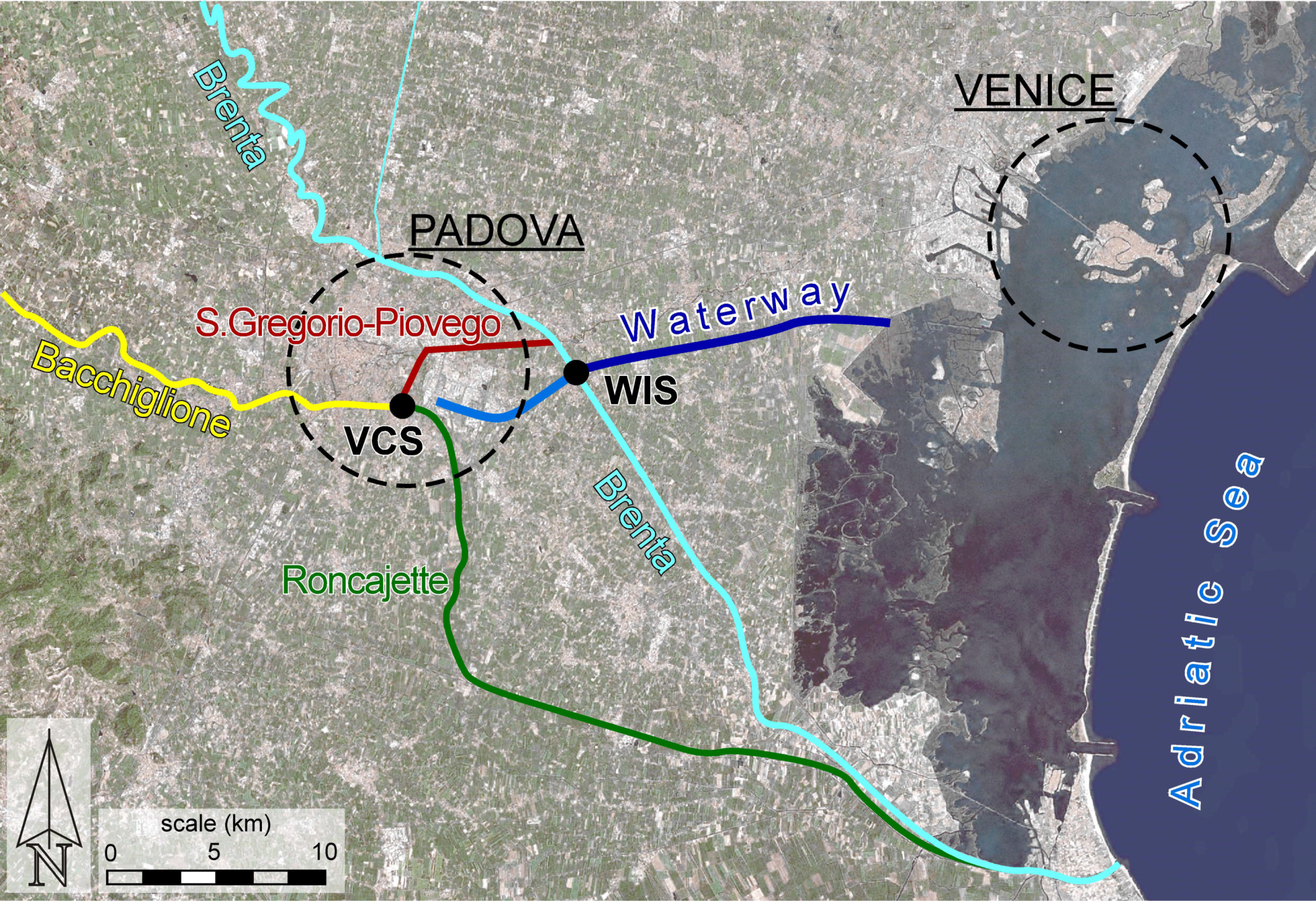
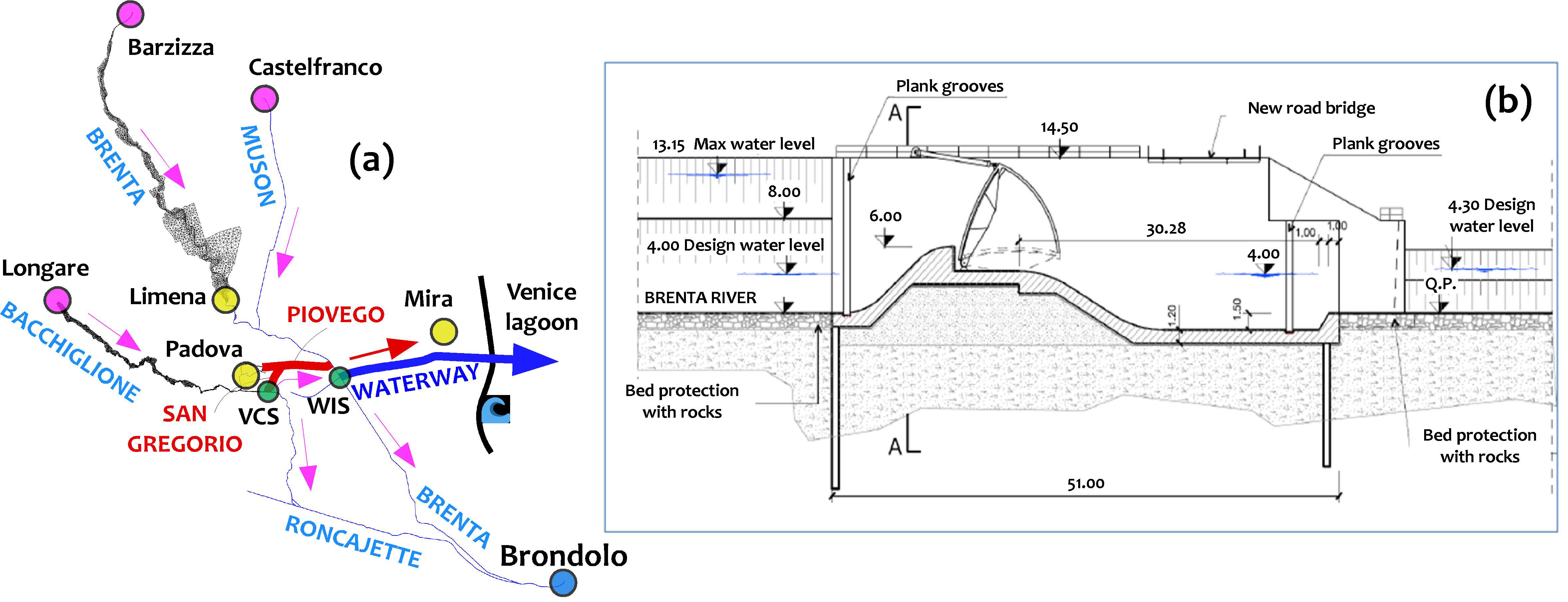
2.1. The Brenta–Bacchiglione River System

The Brenta–Bacchiglione river network is the largest river basin in North-Eastern Italy (5840 km²), which on average conveys almost 100 m³/s of water to the Adriatic Sea. The two major rivers, the Brenta and the Bacchiglione, surround the city of Padova and affect more than 1 million inhabitants (Figure 1).
The hydrographic basin of the Bacchiglione River extends for more than 1900 km², mainly in the Venetian Pre-Alps north of the city of Vicenza [19,20]. The Bacchiglione River is also fed by groundwater springs, principally located in the plain, just north of Vicenza. Its main tributary is the Astico River, with a basin of about 600 km² that flows into the Bacchiglione River, about 25 km upstream of Padova. The Bacchiglione River has been flowing through the historical city center of Padova since the Middle Ages; in the 19th century, it was artificially diverted outside Padova, which experienced increasingly severe floods. In the 20th century, large part of the original stretches of the river located in the center of Padova was finally filled or covered by roads [21]. Currently, the Bacchiglione River can convey a maximum discharge of about 800 m³/s up to Padova. Here, the S. Gregorio-Piovego flood canal, hereinafter denoted as the SGP Canal, allows diverting part of the Bacchiglione River floodwaters onto the Brenta River. Downstream of Padova, the Bacchiglione River flows south-east, where it is known as the Roncajette River (Figure 1), reaching the Brenta River near the Adriatic Sea, and conveying a maximum discharge of about 500 m³/s.
The mountain basin of the Brenta River extends for about 2300 km², in an area located half in the Veneto Region and half in the Autonomous Province of Trento [22]. The Brenta River originates from the Levico and Caldonazzo lakes (Trento); fed by its main tributary Cismon, it can convey more than 2500 m³/s at the outlet of its mountain basin, i.e., at the gauged section of Barzizza, just upstream of the historical city of Bassano del Grappa. Going through the plain between Bassano and Padova, the Brenta River shows a braided and wandering morphology, with an active channel width ranging between 300 m and 800 m, and an average slope of 0.36% [23]. Close to Padova, the Brenta River flows within a narrow channel confined by artificial levees. North of the city center, it is joined by the Muson dei Sassi River, a lowland tributary with a catchment of about 300 km². Downstream of Padova, it runs along the Venice Lagoon; here, it receives the waters from the Bacchiglione River, about 6 km upstream of its mouth in the Adriatic Sea near Brondolo, South of the Venice Lagoon. Currently, the Brenta River can convey a maximum discharge of about 1500 m³/s downstream of Padova [17].
From a historical point of view, it is interesting to note that the Brenta River originally flowed into the Venice Lagoon, north of (and almost parallel to) the waterway segment to be completed. Indeed, starting from the XV century, the Serenissima Republic of Venice diverted all main rivers out of the Venice Lagoon, to counteract the widespread silting up of the lagoon [24]. A new course was dug for the Brenta River (the cyan line between the waterway intake structure (WIS) and the sea in Figure 1); the previous one, known as the Naviglio Brenta, serves as drainage channel for the highly urbanized northern plains and, due to the limited discharge capacity, it cannot be used as flood canal for the Brenta River.

2.1.1. The S. Gregorio-Piovego Flood Canal and the Voltabarozzo Control Structure

In the course of flood events, the secondary channel network of Padova, mainly consisting in the ancient course of the Bacchiglione River within the city center, is disconnected from the Brenta–Bacchiglione river network, and the S. Gregorio-Piovego (SGP) Canal acts as a flood canal [25]. The Voltabarozzo Control Structure, hereinafter denoted as VCS, controls the fraction of floodwaters of the Bacchiglione River to be diverted into the Brenta River, through the SGP Canal. The VCS consists of two distinct multi-gate facilities. The Regolatore facility, made up of four gates, is used to control the water level in the Bacchiglione River upstream of the VCS and the flow rate discharged into the Roncajette River, which is the natural continuation of the Bacchiglione River. The Scaricatore facility, made up of two gates, is used to control the Bacchiglione discharge diverted into the Brenta River, through the SGP Canal. The operation rules at the VCS, aim at minimizing the flood risk for both the city of Padova and the downstream flood-prone areas affected by the Brenta–Bacchiglione river network [25]. Given that the overall flood risk is minimum when it is equally distributed in the whole system, five risk classes (Figure 2) were defined in agreement with the Civil Engineering Department in charge of flood management, which take into account the risk of levee overflowing in the different branches of the river network, as well as the exposure and vulnerability in the adjacent flood-prone areas [25]. Each risk class corresponds to a specific range of four variables that are used as a proxy for flood risk in four different branches of the river network. The four variables are—the flow rate in the Roncajette River, the flow rate in the Brenta River, downstream of the confluence Piovego–Brenta, the water level upstream of the VCS and the minimum levee freeboard along the SGP Canal (Figure 2). If the actual flow variables are within the ranges of a single risk class, the flood risk can be considered to be equally distributed in the whole Brenta–Bacchiglione river system at (and downstream of) the city of Padova. During flood events, the VCS is operated, according to the rules described in [25], to keep the four flow variables within the lowest possible risk class.

2.2. The Padova–Venezia Waterway

2.2.1. Some Historical Notes

In addition to the many natural watercourses that cross the Veneto Region, several waterways were dug in the years to link the most important towns to each other, and especially to the Venice Lagoon, for trade purposes. Commercial needs of the Serenissima Republic of Venice, produced a huge demand for goods and resources from the inland—corn, agricultural products, wood, marble, limestone, and the precious trachyte from the Euganean Hills, which were all transported to Venice through waterways. The city of Padova, set between the Brenta and the Bacchiglione Rivers, in the past, developed an intensive river navigation, becoming a crucial node for trading activities and transport from the mainland to Venice (see http://www.padovanavigazione.it/en/home.htm). In the beginning, Noventa Padovana (East of Padova) was the main fluvial port of the city of Padova; boats coming from the Venice Lagoon stopped here, and people and goods could reach the city center by coaches and carts. In the XIII century, the Piovego Canal was dug to connect Noventa Padovana to the city center of Padova, largely increasing the river navigation. The Bacchiglione River served as a waterway linking Vicenza to Padova, flowing into the city center of Padova along the renaissance city walls and through the old Ezzelino Castle, where it split into two branches. The left branch, named Tronco Maestro, flowed toward the Piovego Canal; the right branch, currently largely filled and covered by roads, flowed under the name of “Naviglio Interno”, within the most ancient city walls towards the Tronco Maestro branch.
Another artificial branch of the Bacchiglione River, named the Battaglia Canal, served as an important waterway linking the south-western corner of Padova to the Euganian Hills and to the Vigenzone–Pontelongo canals, which finally flowed into the Brenta River near Brondolo.

2.2.2. The Waterway Padova–Venice as a Flood Mitigation Structure

The recent flood events that affected the Veneto Region (e.g., the floods of 2010, 2012, and 2018) and possible increase in flooding frequency caused by anthropogenic modifications of drainage networks and climate change [26,27,28,29,30,31], have brought flood risk management to the attention of the public discourse, in order to prevent other tragic consequences and have led to the planning of some hydraulic works to face the flood hazard, such as the waterway of Padova–Venice. This waterway was planned to link the industrial area of Padova to the Venice Lagoon, for a total length of 28 km. The building of the canal started in 1963 and was interrupted in 1981, when about 70% of the work was already completed; practically, only a channel segment east of the Brenta River remained to be dug. In 2016, the Veneto Region allocated 1 million euros for a preliminary design for completing the canal, although the crucial node was still represented by the project funding. Besides the main navigation and commercial purposes, the waterway could serve to reduce the hydraulic hazard (and, accordingly, the hydraulic risk) in the Brenta–Bacchiglione river network at (and downstream of) Padova, by diverting a part of the Brenta floodwaters toward the Venice lagoon, and then to the Adriatic Sea. It was hoped that this could also increase the portion of the Bacchiglione flow rate conveyable through the SGP Canal, as result of the water level reduction at the confluence of Piovego–Brenta. To this purpose, which is still to be assessed, the management of the waterway during the flood events should be integrated with the VCS operation rules.

2.3. The 2DEF Hydrodynamic Model

In this study, the 2DEF hydrodynamic model was used. It is a coupled 1D–2D numerical solver for the Shallow Water Equations [8,32,33,34,35], modified to deal with flooding and drying processes over irregular topographies [36]:
ϑ ( η ) η t + · q = r
D D t ( q Y ) + g η + τ ρ Y R e = 0
In the continuity equation, t is time, η is the free-surface elevation over a datum, g is gravity, q = (qx, qy) is the depth-integrated flow velocity (i.e., discharge per unit width), and ∇∙q is its 2D divergence. The term ϑ(η) is a depth-dependent storage coefficient defined as the ratio between the wet and the total area of a cell, for a given water surface elevation, η, that allows for a smooth wet–dry transition [34,36,37]; r is a source term accounting for possibly contributions of rainfall or infiltration [34].
In the momentum equation, D/Dt is the material (or Lagrangian) time derivative, Y is the effective water depth defined as the volume of water per unit area (thus accounting for porosity), τ = (τx, τy) is the bottom shear stress, ρ is the water density. The model evaluates the depth-integrated horizontal dispersion stresses, Re = (Rex, Rey), using the Boussinesq approximation [38], and the eddy viscosity computed according to Uittenbogaard and van Vossen [39]. Note that the local and advective accelerations are lumped into the material time derivative of the depth-averaged velocity. According to the so-called mixed Eulerian–Lagrangian methods, the material time derivative is replaced by its finite difference formulation, using the method of characteristics [40,41,42]:
D D t ( q Y ) q Y ( q Y ) 0 Δ t
in which ∆t is the computational time step and the subscript “0” denotes a quantity evaluated at the previous time step and at the departure point, i.e., the position occupied by a fluid particle at the previous time step, located backward along the Lagrangian trajectory [40].
In the model, 1D channel elements are superimposed on the 2D domain, as shown in [43], or they can stand alone by connecting computational nodes that are not connected by 2D elements. The governing equations for 1D channels read:
B ( η ) η t + Q r s = 0
D D t ( Q A ) + g η s + g n 2 Q | Q | R H 4 3 A 2 = 0
where s is the channel axis directions, B(η) is the channel width at the water surface, Q is the actual discharge through the 1D channel, Qr is the channel discharge reduced by the amount of flow rate already accounted for by the 2D computational elements possibly overlying the 1D channel element [43], A is the cross-sectional area, and RH is the hydraulic radius.
The effects of momentum exchange between the 1D channels and the possible 2D overlying flow are assumed to be smaller than the bottom resistance, and are therefore neglected. In addition to [43], momentum is conserved at the beginning and at the end of a reach modeled using 1D channel elements; when a 1D channel collects its discharge from the 2D grid, the material derivative in the momentum equation in (3) is evaluated according to Equation (2), with the departure point located within the upstream 2D element; similarly, the velocity at the end-point of a 1D reach is used as departure velocity for computing the material derivative in Equation (1) for the downstream 2D elements that collect the flow conveyed by the 1D channel.
The 2DEF model allows the usage of different kinds of 1D channel elements—open cross-sections with rectangular, trapezoidal, or generic (given by points) shape, and also closed cross-sections of circular, rectangular, or generic shapes (given by points) using the Preissmann slot scheme [44]. The use of 1D channel elements in a coupled 1D–2D scheme is particularly effective to model river reaches with no floodplains and to account for the presence of small channels dissecting the urban and rural area, which play a crucial role on the propagation of flood waves over initially dry areas [43,45,46], and to model relatively straight reaches with simple (i.e., not compound) cross-sections.
Finally, a set of specific 1D-links are available to reproduce overtopping of levees, the presence of sills and the operations of control structures [8,17,43,47,48].
The computational domain is discretized using 2D triangular elements, 1D channel elements and 1D-links. All these elements are connected together to form a 1D–2D, staggered numerical grid. Water surface elevations are defined at the grid nodes, where the continuity equation is solved using the Galerkin’s Finite Element approach [40]. Flow rates, which are conveyed from node to node by both 2D and 1D elements, are evaluated according to the momentum equations associated with each specific type of element. Non-linear terms are linearized in q using variables known at the previous time step, where necessary [37,40,45], to form a semi-implicit numerical scheme that is stable regardless of the celerity of the depth-averaged gravitational waves [42]. Given that the water level, η, is assumed to be piecewise linear, and continuous across the domain, and owing to linearization, the resulting scheme is particularly efficient and accurate in modeling subcritical flows, whereas it is not suitable to deal with rapidly varying flows [49,50], nor with large patches of supercritical flows or shock waves [51,52,53,54,55,56].

2.4. The Computational Domain

The computational grid set up to describe the study area, depicted in Figure 3a, included the Bacchiglione River from Longare (south-east of the city center of Vicenza), the Brenta River from Barzizza (north of the historical town of Bassano del Grappa), and the Muson dei Sassi River from Castelfranco Veneto (north of Padova). The mesh was set up using aerial images, data from LIDAR and MultiBeam surveys, technical maps, and surveyed cross-sections (www.pcn.minambiente.it/mattm, https://idt2.regione.veneto.it). The domain was discretized using about 12,000 nodes, 11,000 2D triangular elements, 1800 1D-channel elements, and 3200 1D-links, most of which were deputed to model the presence of levees. Specifically, we adopted a 2D schematization for the Bacchiglione River from Longare to Padova, which is characterized by the presence of several meanders and artificial chute channels [57], and for the Brenta River from Bassano to Padova, where the riverbed shows a braided and wandering morphology. Downstream of Padova, the Brenta–Bacchiglione river network, including the River Muson dei Sassi and the waterway, was modelled using 1D-channel elements, since all riverbeds follow a nearly rectilinear course with simple cross-sections confined by relatively high artificial levees.
As boundary conditions, we prescribed hourly flow rates gauged at the upstream cross-sections (i.e., Longare, Barzizza, and Castelfranco Veneto) provided by ARPAV (Regional Agency for Environmental Protection of the Veneto Region) and the sea levels recorded close to the mouth of the Brenta River provided by Centro Previsioni e Segnalazioni Maree of the Venice Municipality. The flow rates discharged into the river network by the pumping stations were provided by the land reclamation authority of Brenta–Bacchiglione.
The model parameters were tuned in order to match the time-series of water levels and the point measurements of the discharge performed along the course of the Brenta and Bacchiglione Rivers by ARPAV, during five flood events that occurred in the years 2009–2014. Errors at the flood peaks were generally lower than 20 cm (absolute error) at all water-level gauging stations and were lower than 8% (relative error) in terms of discharges [25].

Schematization of the Waterway

Of course, particular attention was paid to the modeling of the waterway of Padova–Venice. The waterway was modelled following the guidelines of the technical report of the preliminary plan provided by Technital s.p.a. and Beta Studio s.r.l. The canal originates in the Brenta River, downstream of Stra (east of Padova), and flows almost rectilinear in a West–East direction, reaching the Venice Lagoon downstream of the city of Mira (Figure 3a). The bottom width of the channel is 40 m, with a bank slope of about 1:2. The Strickler bed roughness coefficient was chosen for safety reasons in 25 m1/3/s, by hypothesizing a poor riverbed maintenance. The multi-gate intake structure, located in the left bank of the Brenta River, is equipped with two 20 m wide sluice gates, located at the bottom level of 6 m a.s.l., and aimed to control the maximum flow-rate discharged through the waterway (Figure 3b).
The intake structure was schematized with two 1D-links simulating the operation of the two sluice gates, which activated the waterway, when the water level in the Brenta River reached 6 m a.s.l. at the WIS confluence (Figure 3b). Then, an additional 1D-link was linked in series, to limit the flow-rate diverted through the waterway up to a maximum discharge, which was set in order to preserve a levee freeboard of at least 1 m, along the waterway.

3. Results and Discussion

This work aimed to evaluate the effectiveness of the waterway of Padova–Venice, in reducing the hydraulic hazard in the Brenta–Bacchiglione river network, and the hydraulic risk, according to the classification reported in Section 2.1.1.

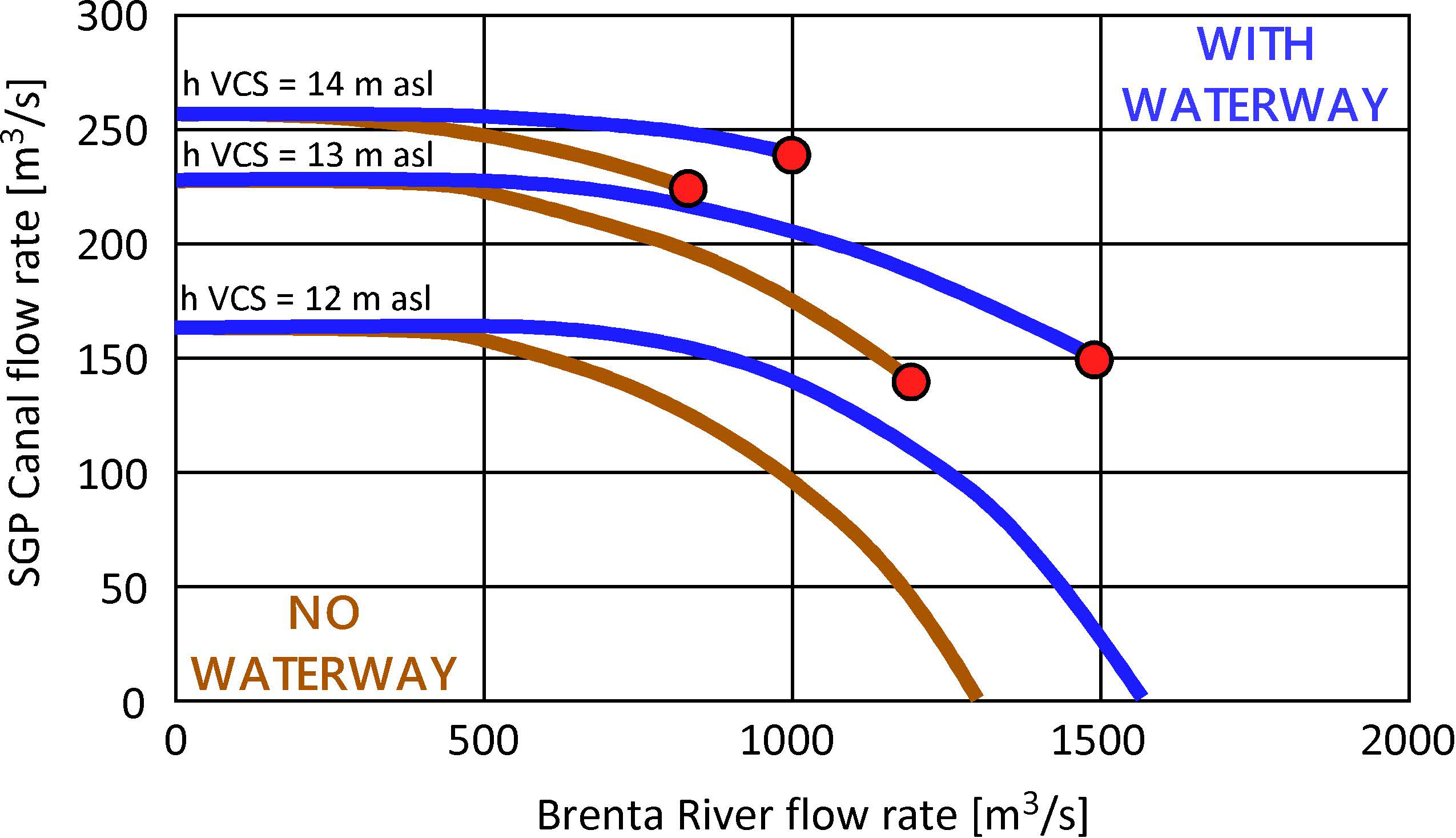
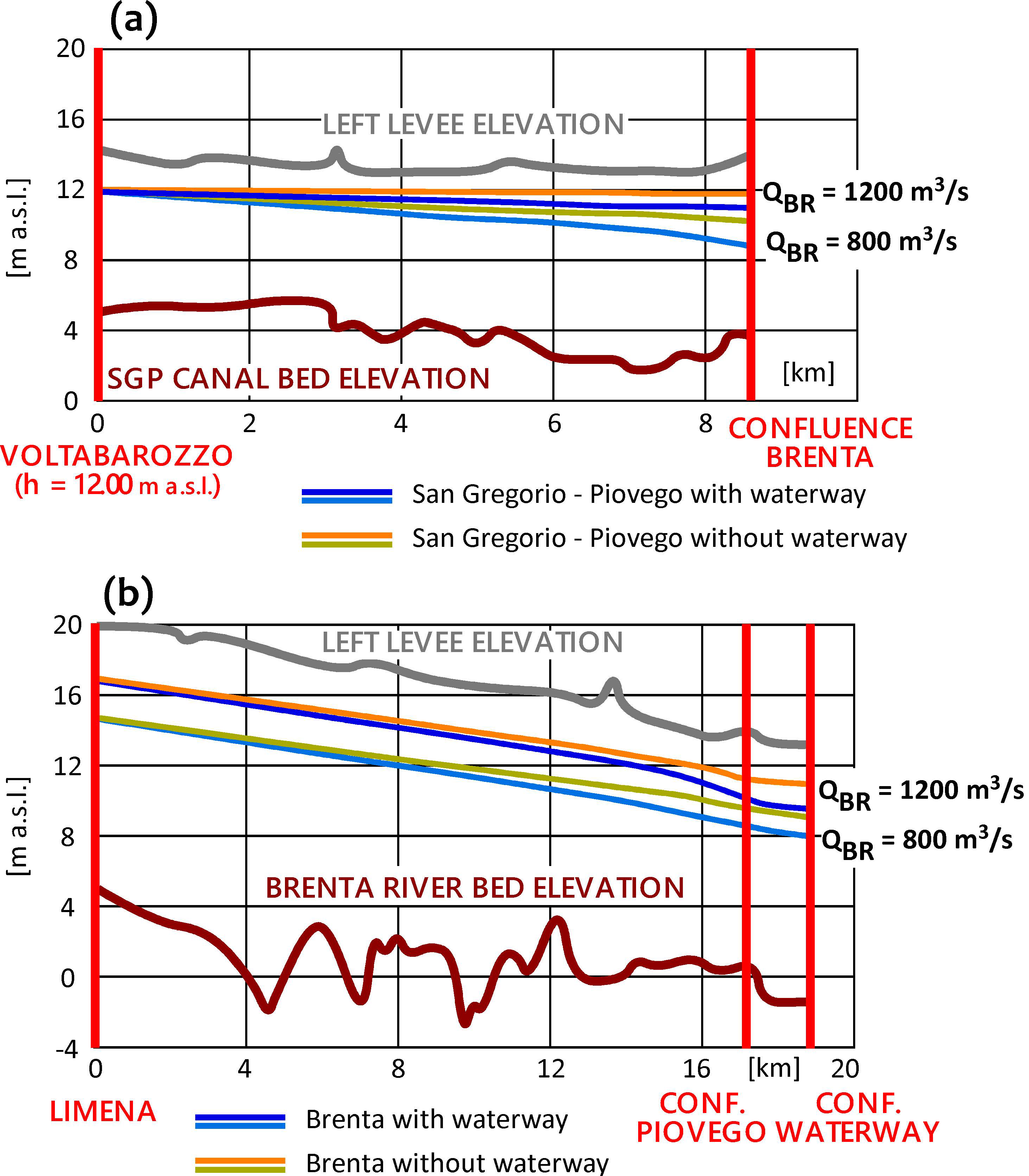
3.1. The Role of Waterway as Diversion Canal: Steady-Flow Preliminary Analysis

To assess the waterway operation as a diversion canal, we initially resorted to the steady flow conditions, which were deemed as acceptable to assess the maximum flow-rate that could be diverted through the waterway and the consequent effects on the operation of the S. Gregorio-Piovego (SGP) Canal (we recall that the SGP Canal connects the Bacchiglione and the Brenta Rivers and allows diverting part of the Bacchiglione floodwaters into the Brenta River). Indeed, the typical duration of flood waves along the Brenta and Bacchiglione Rivers, downstream of Padova, is long when compared to the transit time in the SGP Canal and in the waterway, making unsteady effects negligible for the specific purposes.
As a first step, the 2DEF hydrodynamic model was used to compute, under steady flow conditions, the maximum flow-rate that the Waterway can discharge into the Venice Lagoon. A maximum design flow rate of 350 m³/s was found for the waterway, computed by assuming a minimum freeboard of 1 m, along the entire canal. Furthermore, we found that the water level in the Brenta River at the waterway intake, needed to activate the waterway (6 m a.s.l.), corresponds to a flow rate of almost 400 m³/s in the Brenta River, whereas the design flow rate in the waterway (350 m³/s) is reached, with the sluice gates completely open, when in the Brenta River the flow rate is about 1000 m³/s.
Considering that the maximum conveyance capacity of the Brenta River downstream of the WIS was estimated to be about 1500 m³/s [17], the contribution of the waterway is very important, as it increases the discharge that could safely reach the WIS without producing levee overtopping downstream, to 1850 m³/s (+23%). With reference to the discharge time-series measured at the Barzizza gauging station (Bassano del Grappa, Figure 3), the use of the waterway as diversion canal coincides with increasing the return period associated with the maximum conveyable flood from 13 to 30 years (+130%).
With reference to the SGP Canal, it is to be noted that the maximum flow-rate diverted through the SGP Canal depends not only on the operation at the Voltabarozzo control structure (VCS), but also on the water level in the Brenta River at the confluence of Piovego–Brenta, which affects the downstream water level of the SGP Canal. The confluence of Piovego–Brenta is set about 1.6 km upstream of the waterway intake, and the drawdown profile due to waterway diversion was expected to play an important role in defining the water level at the confluence of Piovego–Brenta. Thus, the hydrodynamic model was used to compare, under steady flow conditions, the maximum flow rate that the SGP Canal could discharge into the Brenta River, with and without the use of the waterway as a flood canal for the Brenta River. The maximum discharge through the SGP Canal, obtained assuming the Scaricatore gates of the VCS were completely open, is reported in Figure 4 as a function of the flow rate in the Brenta River, upstream of the confluence of Piovego–Brenta and of the water level upstream of the VCS. The right endpoints of the different curves (red points in Figure 4) were determined by evaluating when the increasing water level at the confluence of Piovego–Brenta was high enough to cause overflowing along the SGP Canal levees. According to the model, the use of the waterway as diversion canal allows increasing the discharge through the SGP Canal by up to 100 m³/s, with a difference that increases for increasing discharges in the Brenta River and decreasing water levels in the Bacchiglione River, upstream of the VCS.
The reason for the higher discharges that can be diverted through the SGP Canal is actually due to the water level reduction at its downstream endpoint, i.e., the confluence of Piovego–Brenta, as confirmed by the water surface profiles along the SGP Canal and along the Brenta River, upstream of the waterway intake (WIS) shown in Figure 5. The drawdown profile along the Brenta River due to the use of the waterway as a diversion canal (Figure 5b) is still significant at the confluence of Piovego–Brenta, and it causes a larger free-surface slope along the SGP Canal (Figure 5a), which means larger conveyable discharges.
In terms of the risk classes of Figure 2, the extreme values of the Brenta River are obviously increased by the flow rate diverted through the waterway. Considering that the increase of discharge in the SGP Canal is lower than the waterway discharge, the overall effect of the waterway is both the increase of the SGP Canal discharge and a net discharge reduction in the Brenta River, downstream of the WIS. This entails a reduction of hydraulic risk both in the Roncajette River and in the Brenta River, downstream of Padova.

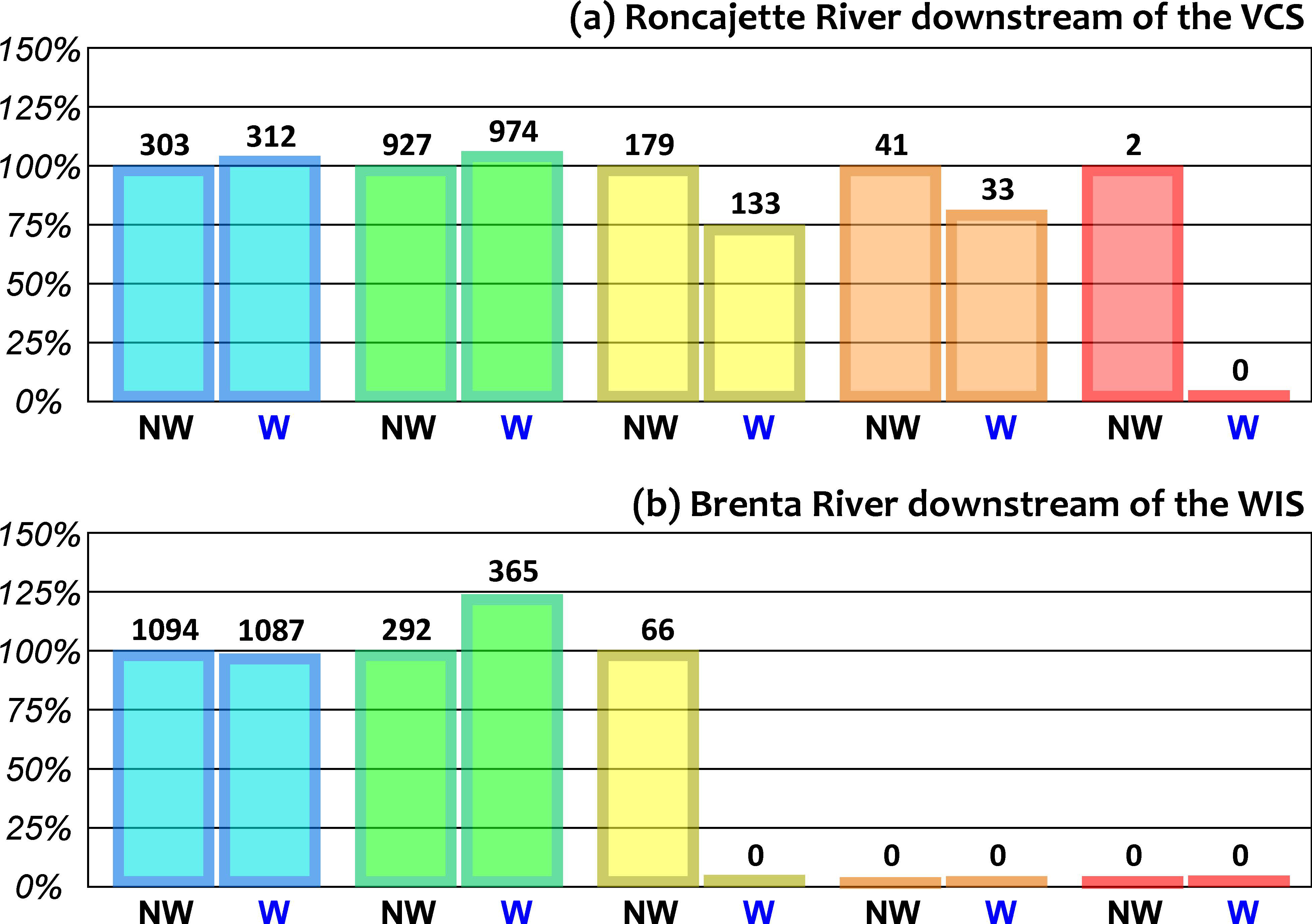
3.2. The Role of Waterway as a Diversion Canal: Real Flood Waves Routing

The 2DEF hydrodynamic model was run to simulate six flood events of the period 2008–2017 (Table 1), to assess the reduction in terms of the hydraulic risk we would have had with the operation of the waterway. Each flood event was characterized by a water-level peak at Longare that was greater than 2 m, which actually corresponded to the activation of the flood protection plan by the Civil Engineering Department in charge of flood management in the Brenta–Bacchiglione river network (i.e., the opening of the two gates of the Scaricatore facility). Moreover, the sum of the discharges of the Brenta River, upstream of Padova, and the flow rate diverted through the SGP Canal was higher than 400 m³/s, which corresponds to the second-risk class in the Brenta River (Figure 2), for at least 12 h. Flood risk was compared by estimating the four variables used as a proxy for flood risk in the procedure for operating the VCS described in [25] and summarized in Section 2.1.1 (Figure 2). Namely, the four variables are—the flow rate in the Roncajette River, the flow rate in the Brenta River downstream of the confluence of Piovego-Brenta, the water level upstream of the VCS and the minimum levee freeboard along the SGP Canal.
As an example, we present the results we obtained for the flood event that occurred between 1 November 2011 and 10 November 2011, when the flow rates of both the Brenta and Bacchiglione Rivers upstream of Padova, exceeded 300 m³/s. Figure 6 shows the discharges along the main branches of the Brenta–Bacchiglione river network downstream of Padova, namely the Roncajette River downstream of the VCS, the SGP Canal, the Brenta River downstream of the confluence of Piovego–Brenta, the Brenta River downstream of the WIS, and the waterway. The comparison of the discharges considering and neglecting the use of the waterway as a diversion canal confirmed that the waterway allows diverting higher flow rates of the Bacchiglione toward the Brenta River, through the SGP Canal (Figure 6b), entailing a reduction of flow rates both in the Roncajette River (Figure 6a) and in the Brenta River, downstream of Padova (Figure 6d). The latter effect is related to the conveyance of the waterway that is greater than the maximum SGP Canal discharge. The flow rates of the Brenta River between the confluence of Piovego-Brenta and the WIS (blue lines in Figure 6c) was obviously increased by the Bacchiglione floodwaters conveyed by the SGP Canal to the Brenta River, yet without increasing the water levels thanks to the drawdown profile, ascribed to the discharge diverted through the waterway.
The analysis of the six recent flood events listed in Table 1, which covered the different sort of VCS operations and was characterized by different flood risk classes, is reported in Figure 7. Figure 7 shows that the use of the waterway as a diversion canal would give additional flexibility to the entire hydraulic network, causing a global reduction of the hydraulic hazard in the Brenta–Bacchiglione river network, downstream of Padova. Specifically, for the six flood events analyzed here, the model results showed that the waterway would have nullified the periods of red risk class and reduced the number of hours at the yellow and orange classes, along the Roncajette River. Yellow class periods in the Brenta River downstream of the WIS would have been nullified as well.

3.3. Additional Considerations

In diverting part of the Brenta floodwaters, the waterway is also expected to convey fine sediments into the Venice Lagoon. This could be seen as an opportunity for the lagoon, whose ecosystem has been suffering a morphological degradation for decades, because of a persistent net loss of sediments that actually produces the deepening of tidal flat and saltmarsh regression. Such a trend could be ascribed to the diversion of the main rivers from the lagoon, brought about by the Serenissima Republic of Venice, starting from the XV century, and later, to the construction of the jetties at the three inlets, completed at the beginning of the last century [24,58,59,60,61,62].
With regards to the risk of flooding in the historical city of Venice, we can affirm that the water level in the Venice Lagoon cannot be significantly affected by the flow rate discharged by the waterway, even in the future scenario of the operation of the Mo.S.E. barriers. Indeed, a sea level increase lower than 5 mm/hour can be expected as a consequence of discharging the 350 m³/s design flow rate of the waterway into the lagoon, during the Mo.S.E. operation (i.e., when the artificial barriers would close the lagoon almost completely). This value is comparable to, e.g., the intra-gates filtration, the direct contribution of rainfall within the Lagoon, and the hydrological runoff [63]; most importantly, this contribution is negligible with respect to the wind setup [64,65,66,67,68].

4. Conclusions

The highly urbanized area that extends from the city of Padova (Veneto Region, Italy) to the Adriatic Sea, is exposed to the floods of the Brenta–Bacchiglione river network. In the present study, we showed that the construction of the waterway of Padova–Venice and, particularly, its use as a flood canal to divert part of the Brenta floodwaters toward the Venice Lagoon allows for reducing the flood hazard in the downstream course of both the Brenta and the Bacchiglione Rivers. This is because using the waterway as a diversion canal would reduce the discharge load of the Brenta River, in turn allowing a more effective operation of the Voltabarozzo control structure that could thus divert more floodwaters from the Bacchiglione to the Brenta River, and then to the Adriatic Sea.
The effect of the waterway on flood risk reduction was tested by simulating several recent flood events characterized by important discharges in both the Brenta and the Bacchiglione Rivers. The results from the modeling study showed that the waterway can reduce the water levels in the Brenta River, up to the confluence of Piovego–Brenta, with an entailing direct benefit in terms of levee freeboards. Moreover, lower water levels at the confluence of Piovego–Brenta can produce an increased discharge capacity of the S. Gregorio-Piovego Canal in diverting floodwaters from the Bacchiglione River to the Brenta River. This would give more flexibility to the Voltabarozzo control structure, which could operate more effectively and efficiently. Finally, the conveyance of the Brenta River would rise proportionally to the flow rate that the waterway could divert toward the Venice lagoon, doubling the return period of the flooding of the urban areas located in the terminal stretch of the Brenta River.
The diversion of the floodwaters to the Venice Lagoon is not expected to cause geomorphological long-term changes in the downstream reach of the Brenta River, as the riverbed here is channelized by relatively narrow artificial levees, which prevent the formation of any bedform [52]. Furthermore, the waterway of Padova–Venice could partially counteract the erosion phenomena affecting the Venice lagoon, without significantly increasing the sea level into the lagoon. Although the sediments introduced through the canal would not be sufficient to solve the problem linked to the net loss of sediments affecting the lagoon, we think it would be a step towards the right direction. The waterway could also perform as a navigable canal—the original function for which was designed more than 50 years ago—promoting river transport, since the waterway would make the city of Padova accessible from any harbor of the Po river valley. The waterway could finally lead to a urban re-composition of the territory through the realization of an ecological corridor along its path and a re-naturalization of the area.

Author Contributions

Conceptualization, R.A.M. and L.D.; Investigation, R.A.M.; Methodology, R.A.M., D.P.V., L.C., and L.D.; Software, R.A.M., D.P.V., and L.C.; Supervision, L.D.; Writing—original draft, R.A.M.; Writing—review & editing, D.P.V. and L.C. All authors have read and agreed to the published version of the manuscript.

Funding

This research received no external funding.

Conflicts of Interest

The authors declare no conflict of interest.

References

  1. European Environmental Agency. Mapping the Impacts of Natural Hazards and Technological Accidents in Europe; European Environmental Agency: Kobenhavn, Denmark, 2010. [Google Scholar]
  2. Arnell, N.W.; Gosling, S.N. The impacts of climate change on river flood risk at the global scale. Clim. Chang. 2016, 134, 387–401. [Google Scholar] [CrossRef] [Green Version]
  3. Ward, P.J.; Jongman, B.; Aerts, J.C.J.H.; Bates, P.D.; Botzen, W.J.W.; Diaz Loaiza, A.; Hallegatte, S.; Kind, J.M.; Kwadijk, J.; Scussolini, P.; et al. A global framework for future costs and benefits of river-flood protection in urban areas. Nat. Clim. Chang. 2017, 7, 642–646. [Google Scholar] [CrossRef]
  4. Dottori, F.; Szewczyk, W.; Ciscar, J.-C.; Zhao, F.; Alfieri, L.; Hirabayashi, Y.; Bianchi, A.; Mongelli, I.; Frieler, K.; Betts, R.A.; et al. Increased human and economic losses from river flooding with anthropogenic warming. Nat. Clim. Chang. 2018, 8, 781–786. [Google Scholar] [CrossRef]
  5. Orlandini, S.; Moretti, G.; Albertson, J.D. Evidence of an emerging levee failure mechanism causing disastrous floods in Italy. Water Resour. Res. 2015, 51, 7995–8011. [Google Scholar] [CrossRef] [Green Version]
  6. Slater, L.J. To what extent have changes in channel capacity contributed to flood hazard trends in England and Wales? Earth Surf. Process. Landf. 2016, 41, 1115–1128. [Google Scholar] [CrossRef] [Green Version]
  7. Vacondio, R.; Aureli, F.; Ferrari, A.; Mignosa, P.; Dal Palù, A. Simulation of the January 2014 flood on the Secchia river using a fast and high-resolution 2D parallel shallow-water numerical scheme. Nat. Hazards 2016, 80, 103–125. [Google Scholar] [CrossRef]
  8. Viero, D.P.; D’Alpaos, A.; Carniello, L.; Defina, A. Mathematical modeling of flooding due to river bank failure. Adv. Water Resour. 2013, 59, 82–94. [Google Scholar] [CrossRef]
  9. Kundzewicz, Z.W.; Kanae, S.; Seneviratne, S.I.; Handmer, J.; Nicholls, N.; Peduzzi, P.; Mechler, R.; Bouwer, L.M.; Arnell, N.; Mach, K.; et al. Flood risk and climate change: Global and regional perspectives. Hydrol. Sci. J. 2014, 59, 1–28. [Google Scholar] [CrossRef] [Green Version]
  10. Slater, L.J.; Singer, M.B.; Kirchner, J.W. Drivers of flood hazard. Geophys. Res. Lett. 2015, 42, 370–376. [Google Scholar] [CrossRef] [Green Version]
  11. Slater, L.J.; Villarini, G. Recent trends in U.S. flood risk. Geophys. Res. Lett. 2016, 43, 12428–12436. [Google Scholar] [CrossRef] [Green Version]
  12. Viero, D.P.; Roder, G.; Matticchio, B.; Defina, A.; Tarolli, P. Floods, landscape modifications and population dynamics in anthropogenic coastal lowlands: The Polesine (northern Italy) case study. Sci. Total Environ. 2019, 651, 1435–1450. [Google Scholar] [CrossRef] [PubMed]
  13. Rayment, M.; Conway, M.; Batrakova, S.; McNeil, D.; Christie, M.; Remoundou, K. Estimating the Impact on Public Benefits from Changes in Investment in the Environment Agency Waterways; Technical Report; ICF GHK: London, UK, 2014. [Google Scholar]
  14. Galil, B.S.; Nehring, S.; Panov, V. Waterways as invasion highways-impact of climate change and globalization. In Biological Invasions; Springer: Berlin/Heidelberg, Germany, 2007; pp. 59–74. [Google Scholar]
  15. Rose, C.B.; Walker, L. Inland waterway systems-a solution to drought and flooding issues. In Water Resources in the Built Environment; John Wiley & Sons Ltd.: Chichester, UK, 2014; pp. 180–195. [Google Scholar]
  16. Ionescu, R.-V. Inland waterways’ importance for the European economy. Case study: Romanian inland Waterways transport. J. Danub. Stud. Res. 2016, 6, 207–2019. [Google Scholar]
  17. Martini, P.; Carniello, L.; Avanzi, C. Two dimensional modelling of flood flows and suspended sedimenttransport: The case of the Brenta river, Veneto (Italy). Nat. Hazards Earth Syst. Sci. 2004, 4, 165–181. [Google Scholar] [CrossRef] [Green Version]
  18. Zanetti, P.G. Acque di Padova. 150 Anni del Canale Scaricatore; Cierre Editore: Verona, Italy, 2013; ISBN 9788883147265. [Google Scholar]
  19. Mazzoleni, M.; Verlaan, M.; Alfonso, L.; Monego, M.; Norbiato, D.; Ferri, M.; Solomatine, D.P. Can assimilation of crowdsourced data in hydrological modelling improve flood prediction? Hydrol. Earth Syst. Sc. 2017, 21, 839–861. [Google Scholar] [CrossRef] [Green Version]
  20. Viero, D.P. Comment on “Can assimilation of crowdsourced data in hydrological modelling improve flood prediction?” by Mazzoleni et al. (2017). Hydrol. Earth Syst. Sci. 2018, 22, 171–177. [Google Scholar] [CrossRef] [Green Version]
  21. Mozzi, P.; Piovan, S.; Rossato, S.; Cucato, M.; Abbà, T.; Fontana, A. Palaeohydrography and early settlements in Padua (Italy). Quat. Ital. J. Quat. Sci. 2010, 23, 387–400. [Google Scholar]
  22. Prosdocimi, M.; Fontana, D.G.; Tarolli, P.; Giupponi, C.; Bojovic, D. Pilot Activities in Brenta River Basin (Italy); Technical Report; University of Padua, Department Tesaf, Veneto Region, Cà Foscari University of Venice, Department of Economics: Venice, Italy, 2014. [Google Scholar]
  23. Moretto, J.; Delai, F.; Lenzi, M.A. Hybrid DTMS derived by lidar and colour bathymetry for assessing fluvial geomorphic changes after flood events in gravel-bed rivers (Tagliamento, Piave and Brenta rivers, Italy). Int. J. Saf. Secur. Eng. 2013, 3, 128–140. [Google Scholar] [CrossRef]
  24. D’Alpaos, L. Fatti e Misfatti di Idraulica Lagunare. La Laguna di Venezia Dalla Diversione dei Fiumi Alle Nuove Opere Alle Bocche di Porto; Istituto Veneto di SS.LL.AA., Memorie, Classe di Scienze Fisiche, Matematiche e Naturali: Venezia, Italy, 2010; Volume 44. [Google Scholar]
  25. Mel, R.; Viero, D.P.; Carniello, L.; D’Alpaos, L. Optimal floodgate operation for river flood management: The case study of Padova (Italy). J. Hydrol. Reg. Stud. accepted.
  26. Alfieri, L.; Bisselink, B.; Dottori, F.; Naumann, G.; de Roo, A.; Salamon, P.; Wyser, K.; Feyen, L. Global projections of river flood risk in a warmer world. Earth’s Futur. 2017, 5, 171–182. [Google Scholar] [CrossRef]
  27. Blöschl, G.; Hall, J.; Viglione, A.; Perdigão, R.A.P.; Parajka, J.; Merz, B.; Lun, D.; Arheimer, B.; Aronica, G.T.; Bilibashi, A.; et al. Changing climate both increases and decreases European river floods. Nature 2019, 573, 108–111. [Google Scholar] [CrossRef]
  28. Mel, R.; Sterl, A.; Lionello, P. High resolution climate projection of storm surge at the Venetian coast. Nat. Hazards Earth Syst. Sci. 2013, 13, 1135–1142. [Google Scholar] [CrossRef] [Green Version]
  29. Miller, J.D.; Hutchins, M. The impacts of urbanisation and climate change on urban flooding and urban water quality: A review of the evidence concerning the United Kingdom. J. Hydrol. Reg. Stud. 2017, 12, 345–362. [Google Scholar] [CrossRef] [Green Version]
  30. Pijl, A.; Brauer, C.C.; Sofia, G.; Teuling, A.J.; Tarolli, P. Hydrologic impacts of changing land use and climate in the Veneto lowlands of Italy. Anthropocene 2018, 22, 20–30. [Google Scholar] [CrossRef]
  31. Sofia, G.; Tarolli, P. Hydrological Response to~30 years of agricultural surface water management. Land 2017, 6, 3. [Google Scholar] [CrossRef] [Green Version]
  32. D’Alpaos, L.; Defina, A. Venice Lagoon Hydrodynamics Simulation by Coupling 2D and 1D Finite Element Models, Proceedings of the 8th Conference on Finite Elements in Fluids in New Trends and Applications, Barcelona, Spain, 20–24 September 1993; Morgan, K., Onate, E., Periaux, J., Peraire, J., Zienkiewicz, O., Eds.; Pineridge Press: Barcelona, Spain, 1993; pp. 20–24. [Google Scholar]
  33. Defina, A.; D’Alpaos, L.; Matticchio, B. A new set of equations for very shallow water and partially dry areas suitable to 2D numerical models. In Modelling Flood Propagation Over Initially Dry Areas; Molinaro, P., Natale, L., Eds.; American Society of Civil Engineers: New York, NY, USA, 1994; pp. 72–81. [Google Scholar]
  34. Viero, D.P.; Peruzzo, P.; Carniello, L.; Defina, A. Integrated mathematical modeling of hydrological and hydrodynamic response to rainfall events in rural lowland catchments. Water Resour. Res. 2014, 50, 5941–5957. [Google Scholar] [CrossRef] [Green Version]
  35. Viero, D.P.; Defina, A. Water age, exposure time, and local flushing time in semi-enclosed, tidal basins with negligible freshwater inflow. J. Mar. Syst. 2016, 156, 16–29. [Google Scholar] [CrossRef]
  36. Defina, A. Two-dimensional shallow flow equations for partially dry areas. Water Resour. Res. 2000, 36, 3251. [Google Scholar] [CrossRef] [Green Version]
  37. Viero, D.P. Modelling urban floods using a finite element staggered scheme with an anisotropic dual porosity model. J. Hydrol. 2019, 568, 247–259. [Google Scholar] [CrossRef] [Green Version]
  38. Stansby, P.K. A mixing-length model for shallow turbulent wakes. J. Fluid Mech. 2003, 495, 369–384. [Google Scholar] [CrossRef]
  39. Uittenbogaard, R.; van Vossen, B. Subgrid-scale model for quasi-2D turbulence in shallow water. In Shallow Flows; Taylor & Francis: Abingdon, UK, 2004; pp. 575–582. [Google Scholar]
  40. Defina, A. Numerical experiments on bar growth. Water Resour. Res. 2003, 39, 1–12. [Google Scholar] [CrossRef]
  41. Giraldo, F.X. The Lagrange-Galerkin method for the two-dimensional shallow water equations on adaptive grids. Int. J. Numer. Meth. Fl. 2000, 33, 789–832. [Google Scholar] [CrossRef]
  42. Walters, R.A.; Casulli, V. A robust, finite element model for hydrostatic surface water flows. Commun. Numer. Meth. Engng. 1998, 14, 931–940. [Google Scholar] [CrossRef]
  43. D’Alpaos, L.; Defina, A.; D’Alpaos, L.; Defina, A. Mathematical modeling of tidal hydrodynamics in shallow lagoons: A review of open issues and applications to the Venice Lagoon. Comput. Geosci. 2007, 33, 476–496. [Google Scholar] [CrossRef]
  44. Cunge, J.A.; Wegner, M. Numerical integration of Barré de Saint-Venant’s flow equations by means of an implicite scheme of finite differences. Houille Blanche 1964, 1, 33–39. [Google Scholar] [CrossRef] [Green Version]
  45. Viero, D.P.; Valipour, M. Modeling anisotropy in free-surface overland and shallow inundation flows. Adv. Water Resour. 2017, 104, 1–14. [Google Scholar] [CrossRef]
  46. D’Alpaos, L.; Defina, A.; Matticchio, B. A Coupled 2D and 1D Finite Element Model for Simulating Tidal Flow in the Venice Channel Network, Proceedings of the Ninth International Conference on Finite Elements in Fluids New Trends and Applications, Venezia, Italy, 15–21 October 1995; Morandi Cecchi, M., Morgan, K., Periaux, J., Schrefler, B.A., Zienkiewicz, O.C., Eds.; SM Legatoria: Venezia, Italy, 1995; pp. 1397–1406. [Google Scholar]
  47. Viero, D.P.; Defina, A. Extended theory of hydraulic hysteresis in open-channel flow. J. Hydraul. Eng. 2017, 143, 06017014. [Google Scholar] [CrossRef] [Green Version]
  48. Viero, D.P.; Defina, A. Multiple states in the flow through a sluice gate. J. Hydraul. Res. 2019, 57, 39–50. [Google Scholar] [CrossRef] [Green Version]
  49. Viero, D.P.; Peruzzo, P.; Defina, A. Positive surge propagation in sloping channels. Water 2017, 9, 518. [Google Scholar] [CrossRef]
  50. Viero, D.P.; Defina, A. Consideration of the mechanisms for tidal bore formation in an idealized planform geometry. Water Resour. Res. 2018, 54, 5670–5686. [Google Scholar] [CrossRef] [Green Version]
  51. Defina, A.; Susin, F.M.; Viero, D.P. Numerical study of the Guderley and Vasilev reflections in steady two-dimensional shallow water flow. Phys. Fluids 2008, 20. [Google Scholar] [CrossRef] [Green Version]
  52. Defina, A.; Susin, F.M.; Viero, D.P. Bed friction effects on the stability of a stationary hydraulic jump in a rectangular upward sloping channel. Phys. Fluids 2008, 20. [Google Scholar] [CrossRef] [Green Version]
  53. Defina, A.; Viero, D.P. Open channel flow through a linear contraction. Phys. Fluids 2010, 22. [Google Scholar] [CrossRef]
  54. Guinot, V. Multiple porosity shallow water models for macroscopic modelling of urban floods. Adv. Water Resour. 2012, 37, 40–72. [Google Scholar] [CrossRef]
  55. Viero, D.P.; Susin, F.M.; Defina, A. A note on weak shock wave reflection. Shock Waves 2013, 23, 505–511. [Google Scholar] [CrossRef]
  56. Ferrari, A.; Viero, D.P. Floodwater pathways in urban areas: A method to compute porosity fields for anisotropic subgrid models in differential form. J. Hydrol. under review.
  57. Viero, D.P.; Lopez Dubon, S.; Lanzoni, S. Chute cutoffs in meandering rivers: Formative mechanisms and hydrodynamic forcing. In Fluvial Meanders and Their Sedimentary Products in the Rock Record (IAS SP 48); Ghinassi, M., Colombera, L., Mountney, N., Reesink, A.J.H., Eds.; John Wiley & Sons: Hoboken, NJ, USA, 2018; pp. 201–230. [Google Scholar]
  58. Marani, M.; D’Alpaos, A.; Lanzoni, S.; Carniello, L.; Rinaldo, A. Biologically-controlled multiple equilibria of tidal landforms and the fate of the Venice lagoon. Geophys. Res. Lett. 2007, 34, L11402. [Google Scholar] [CrossRef]
  59. Carniello, L.; Defina, A.; D’Alpaos, L. Morphological evolution of the Venice lagoon: Evidence from the past and trend for the future. J. Geophys. Res. 2009, 114, F04002. [Google Scholar] [CrossRef]
  60. Bendoni, M.; Mel, R.; Solari, L.; Lanzoni, S.; Francalanci, S.; Oumeraci, H. Insights into lateral marsh retreat mechanism through localized field measurements. Water Resour. Res. 2016, 52, 1446–1464. [Google Scholar] [CrossRef] [Green Version]
  61. Sarretta, A.; Pillon, S.; Molinaroli, E.; Guerzoni, S.; Fontolan, G. Sediment budget in the lagoon of Venice, Italy. Cont. Shelf Res. 2010, 30, 934–949. [Google Scholar] [CrossRef] [Green Version]
  62. Tommasini, L.; Carniello, L.; Ghinassi, M.; Roner, M.; D’Alpaos, A. Changes in the wind-wave field and related salt-marsh lateral erosion: Inferences from the evolution of the Venice lagoon in the last four centuries. Earth Surf. Process. Landf. 2019, 44, 1633–1646. [Google Scholar] [CrossRef]
  63. Rinaldo, A.; Nicótina, L.; Alessi Celegon, E.; Beraldin, F.; Botter, G.; Carniello, L.; Cecconi, G.; Defina, A.; Settin, T.; Uccelli, A.; et al. Sea level rise, hydrologic runoff, and the flooding of Venice. Water Resour. Res. 2008, 44. [Google Scholar] [CrossRef] [Green Version]
  64. Mel, R.; Carniello, L.; D’Alpaos, L. Addressing the effect of the Mo.S.E. barriers closure on wind setup within the Venice lagoon. Estuar. Coast. Shelf Sci. 2019, 225, 106249. [Google Scholar] [CrossRef]
  65. Mel, R.; Carniello, L.; D’Alpaos, L. Dataset of wind setup in a regulated Venice lagoon. Data Br. 2019, 26, 104386. [Google Scholar] [CrossRef]
  66. Mel, R.; Viero, D.P.; Carniello, L.; Defina, A.; D’Alpaos, L. Simplified methods for real-time prediction of storm surge uncertainty: The city of Venice case study. Adv. Water Resour. 2014, 71, 177–185. [Google Scholar] [CrossRef]
  67. Mel, R.; Lionello, P. Probabilistic dressing of a storm surge prediction in the Adriatic sea. Adv. Meteorol. 2016, 2016, 1–8. [Google Scholar] [CrossRef] [Green Version]
  68. Chen, C.; Liu, H.; Beardsley, R.C. An Unstructured grid, finite-volume, three-dimensional, primitive equations ocean model: Application to coastal ocean and estuaries. J. Atmos. Ocean. Technol. 2003, 20, 159–186. [Google Scholar] [CrossRef]
Figure 1. The Brenta–Bacchiglione river network from Padova to the Adriatic Sea. The yellow line represents the Bacchiglione River; the green line is the Roncajette River, which originates from the Voltabarozzo control structure (VCS); the cyan line is the Brenta River, with its lowland tributary, the Muson dei Sassi River; the blue line is the Waterway Padova–Venice (in light blue the segment already built, in dark blue the segment that is still to be completed). The black points represent the Voltabarozzo control structure (VCS) and the waterway intake structure (WIS).
Water 12 01609 g001
Figure 2. Definition of the five hydraulic risk classes in four branches of the Brenta–Bacchiglione river network—flow rate in the Roncajette River; water level upstream of the VCS; flow rate in the Brenta River downstream of the WIS; and minimum levee freeboard along the S. Gregorio-Piovego (SGP) Canal.
Water 12 01609 g002
Figure 3. (a) Domain of the study and the computational mesh used to model flood propagation in the Brenta–Bacchiglione river network. Violet points denote the inflow boundary conditions; green points are the hydraulic facilities (the Voltabarozzo control structure, VCS, and the waterway intake structure, WIS); the blue point locates the mouth of the Brenta in the Adriatic Sea at Brondolo. (b) Details of the waterway intake structure (WIS).
Water 12 01609 g003
Figure 4. Maximum flow rates that can be conveyed through the SGP Canal into the Brenta River (i.e., gates of the Scaricatore facility were completely open) as a function of the flow rates in the Brenta River. Brown lines represent the current condition, blue lines represent the effect of using the waterway of Padova–Venice as a diversion canal. Different set of lines refer to different water level upstream of the VCS; red circles denote the maximum discharge through the SGP Canal for which the levees are not overtopped.
Water 12 01609 g004
Figure 5. The role of the waterway in reducing the water levels in the SGP Canal and in the Brenta River, under steady flow conditions. Examples with water level upstream of the VCS of 12 m a.s.l. and flow rates in the Brenta River, QBR, of 800 and 1200 m³/s. Brown line is the bed elevation; grey lines are the elevation of the lower levee. (a) Water levels along the SGP Canal from the VCS to the confluence of Piovego–Brenta; and (b) water levels in the Brenta River from the Limena to the WIS.
Water 12 01609 g005
Figure 6. Simulation of the 01–10 November 2011 flood event. Comparisons between flow rates computed, without (current conditions, dark colors, thin lines) and with (light colors, thick lines), the use of the waterway as a diversion canal. Black lines represent the flow rates upstream of Padova. The waterway allows—(a) reducing the flow rates in the Roncajette River, (b) increasing the flow rates of the Bacchiglione River that the SGP Canal could divert to the Brenta River (green lines), (c) increasing the flow rates of the Brenta River between the confluence of Piovego–Brenta and the WIS (blue lines) without increasing the water levels, and (d) flattening the flood hydrograph of the Brenta River downstream of the WIS.
Water 12 01609 g006
Figure 7. Effect of the waterway as a diversion canal on hydraulic risk in the Brenta–Bacchiglione river network. The number of hours (bold numbers) spent in each of the risk classes defined in Section 2.1.1, using (W) and without using (NW) the Waterway as diversion canal, for the Roncajette River (a) and for the Brenta River downstream of the WIS (b). Histogram bars are normalized with respect to the case of no waterway use.
Water 12 01609 g007
Table 1. List of flood events in the period of 2008–2017 selected for studying the effectiveness of the waterway as a flood canal for the Brenta–Bacchiglione river network.
n of EventBeginEnd
12 February 200910 February 2009
222 April 20092 May 2009
318 December 201028 December 2010
41 November 201110 November 2011
511 May 201321 May 2013
625 January 20148 February 2014

