Flood Inundation Mapping at Ungauged Basins Using Coupled Hydrometeorological–Hydraulic Modelling: The Catastrophic Case of the 2006 Flash Flood in Volos City, Greece
Abstract
:1. Introduction
2. Materials and Methods
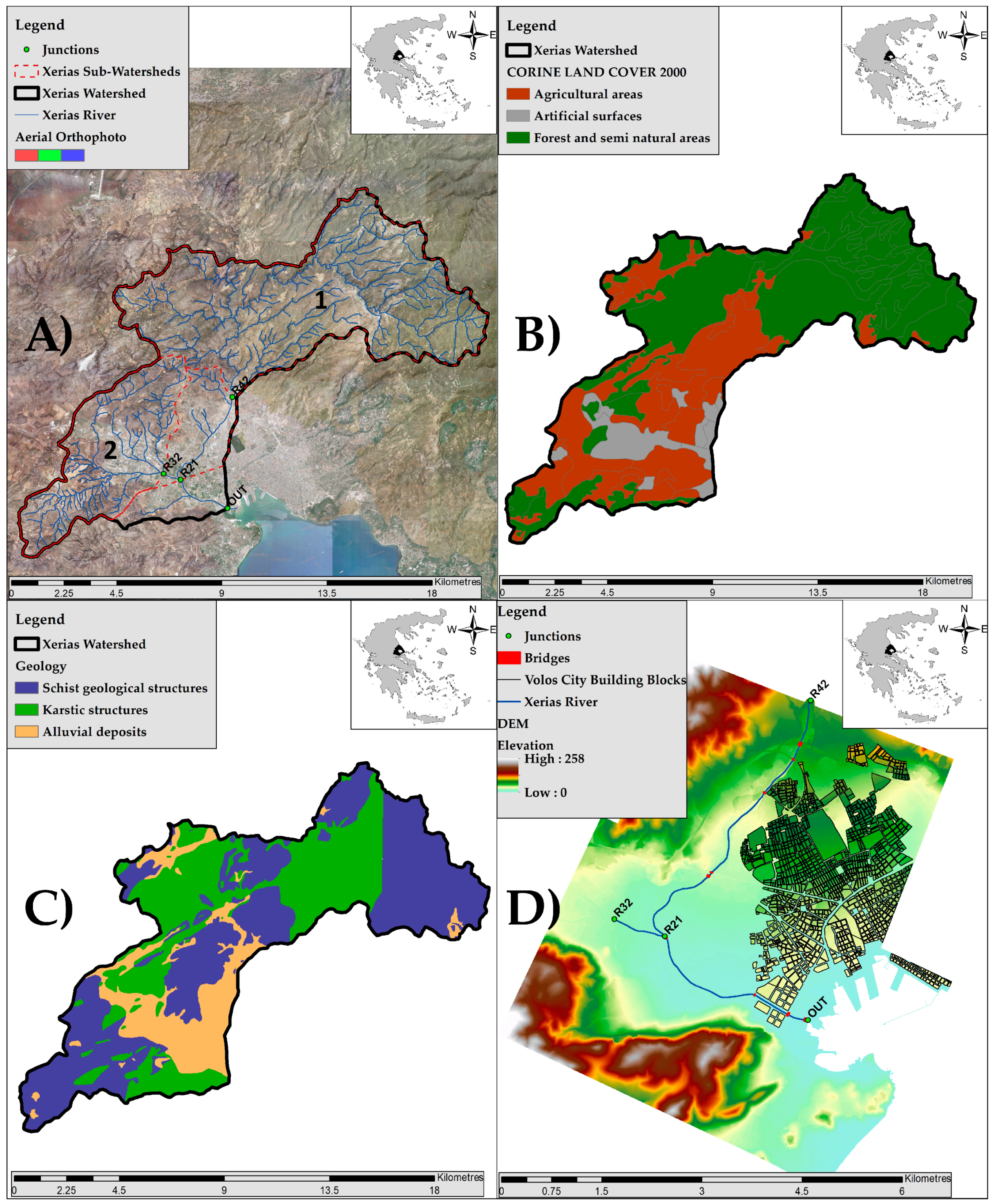
2.1. Study Area
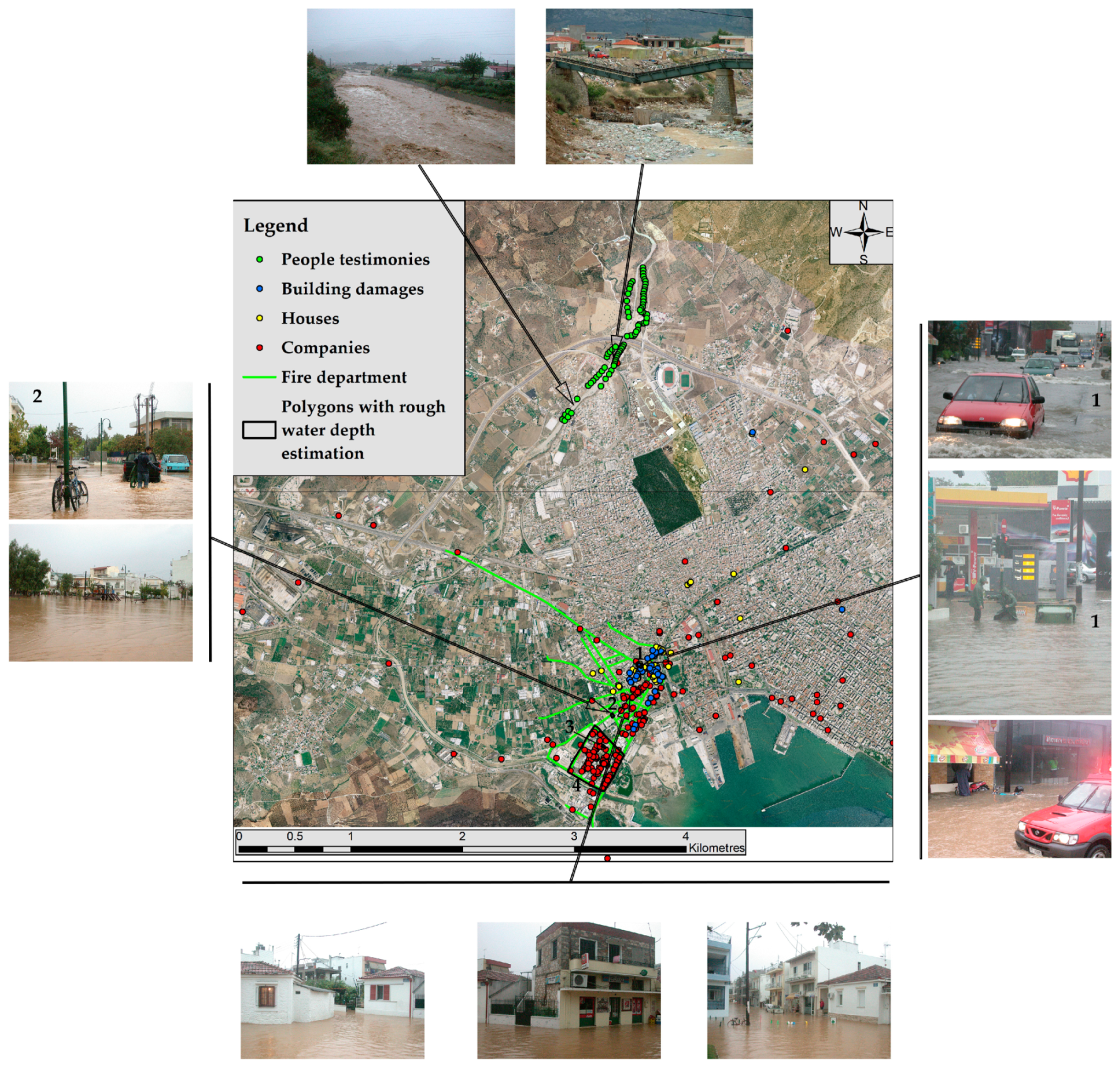
2.2. Flood Data Collection
2.2.1. Damage Estimation Reports
2.2.2. Photos and Videos
2.2.3. Local Mass-Media Reports
2.2.4. Interviews with Eyewitnesses and/or Judicial Reports.
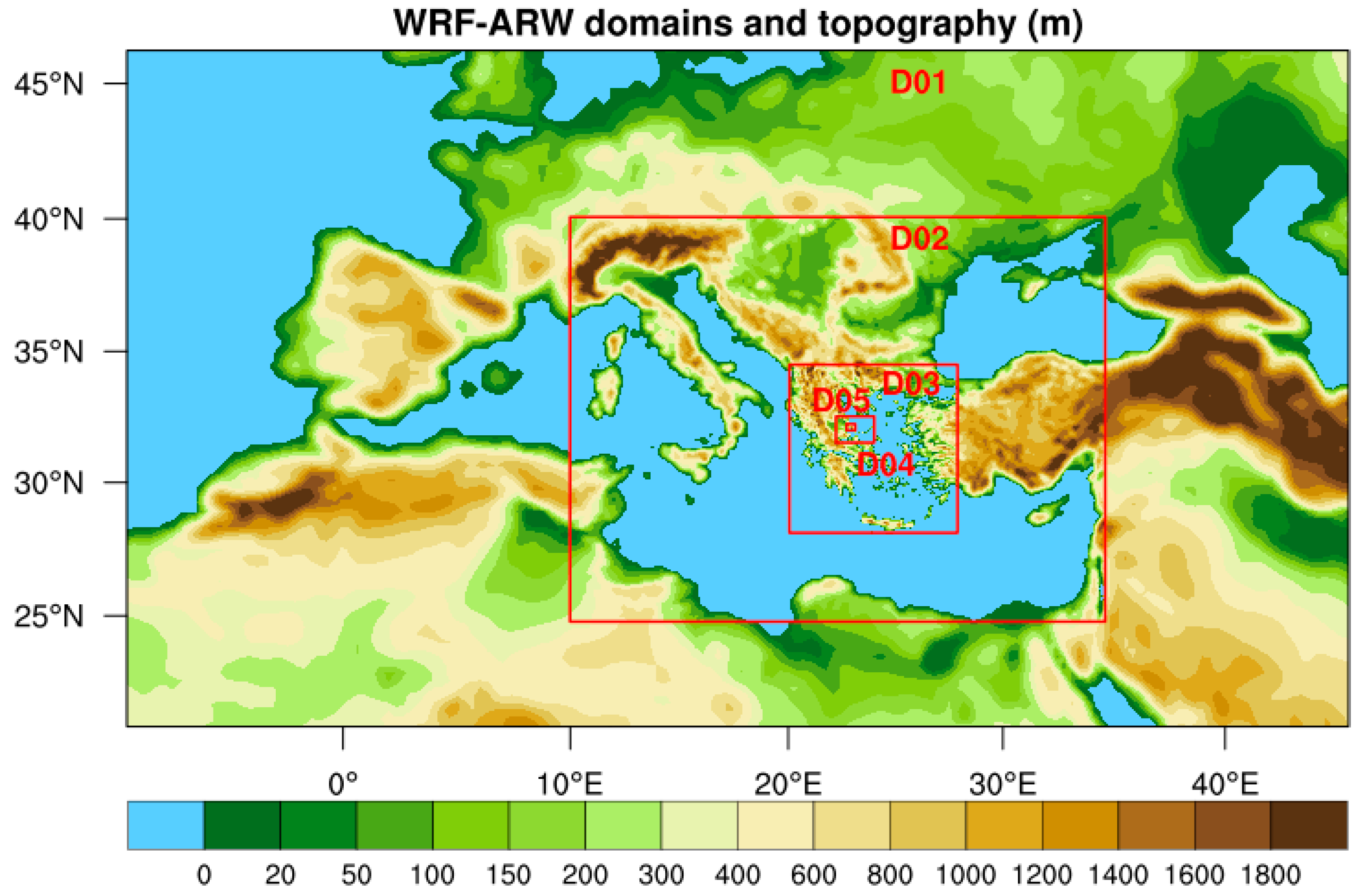
2.3. Μeteorological Analysis Methods and Weather Model Setup
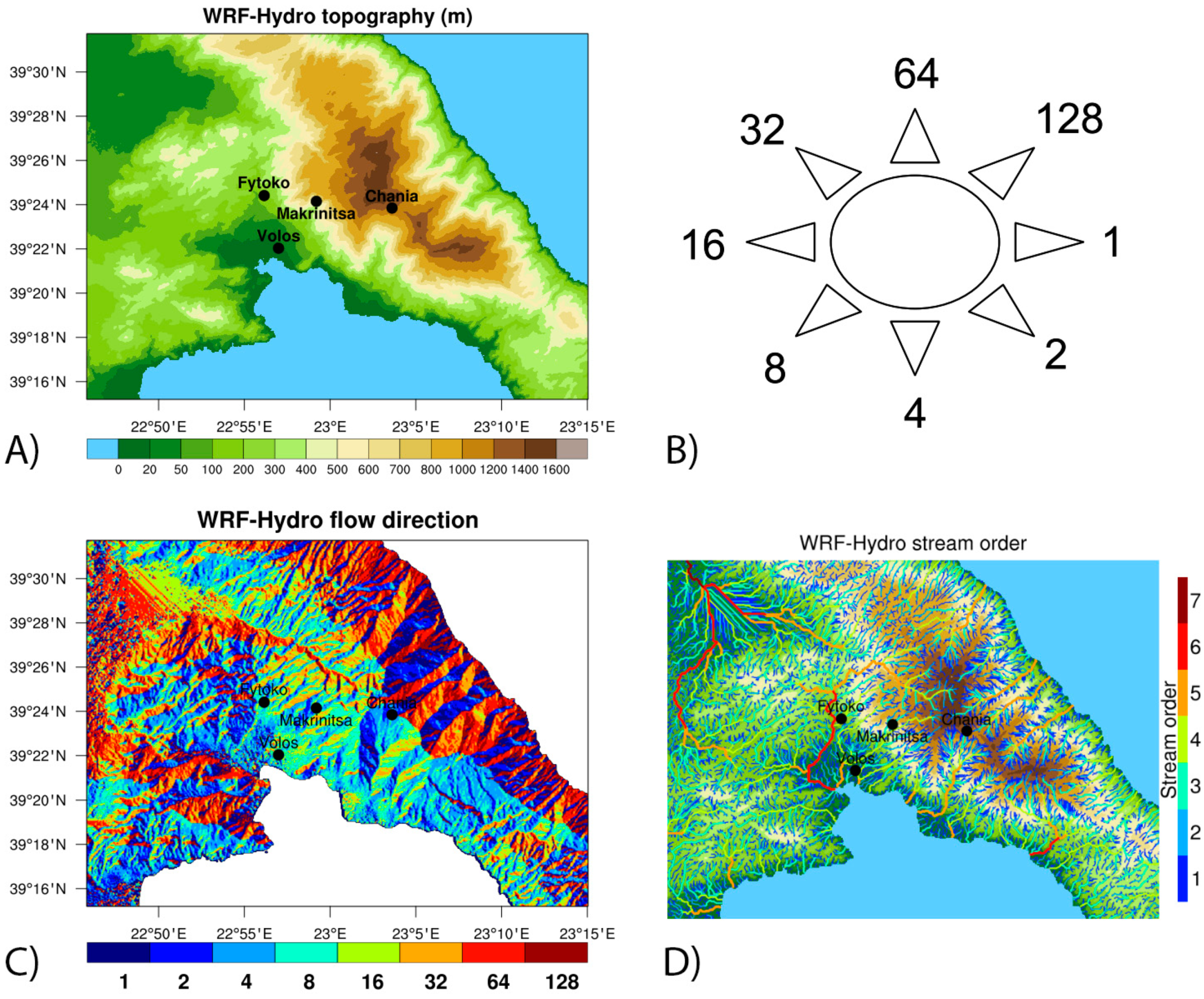
2.4. Hydrological Model Setup
2.5. Hydraulic Model Setup
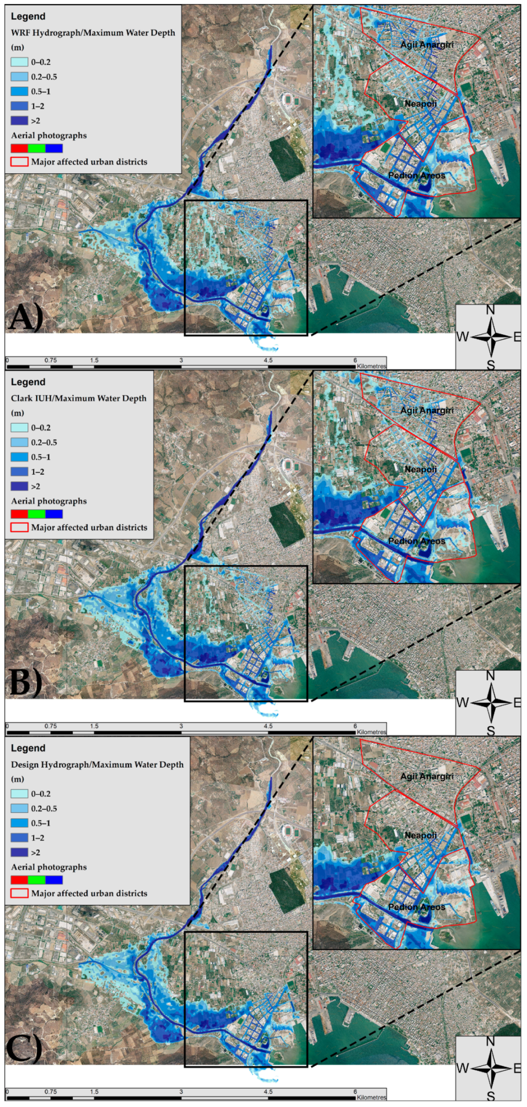
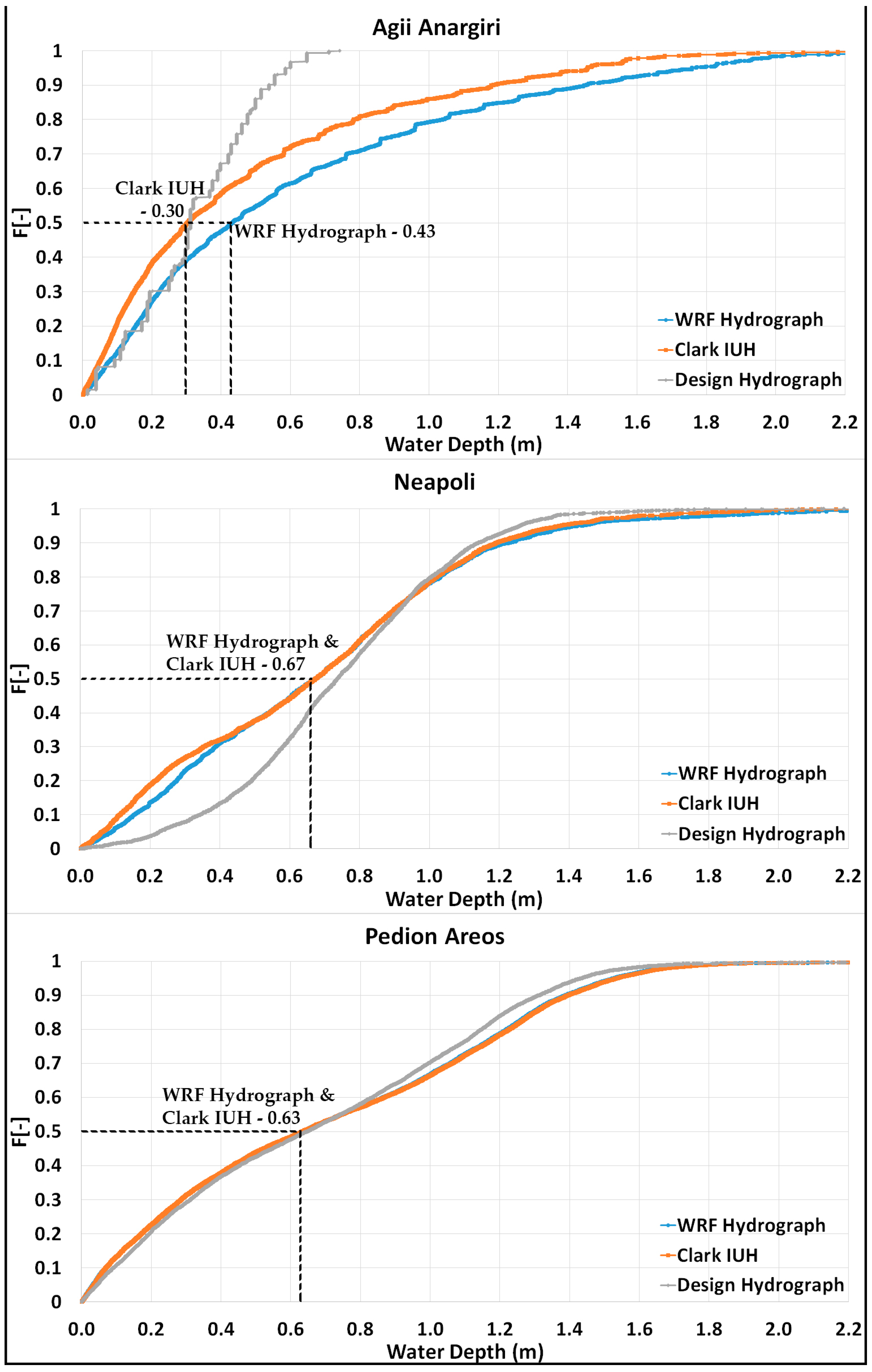
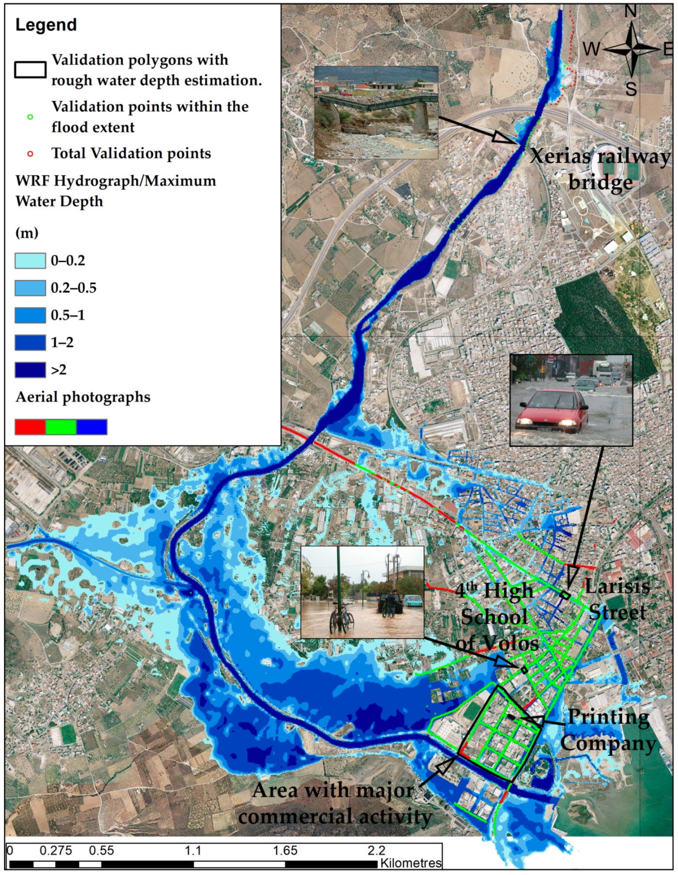
- Hydrographs generated from the combined weather–hydrological model presented in Section 3.1. These flood hydrographs are named from now on as “WRF hydrograph”.
- Design hydrographs based on a previous study [5]. The design hydrographs are estimated for the return period of 100 years (T = 100 years) and the second type of antecedent soil moisture conditions (AMCII). These hydrographs are named from now on as “Design Hydrograph”.
3. Results
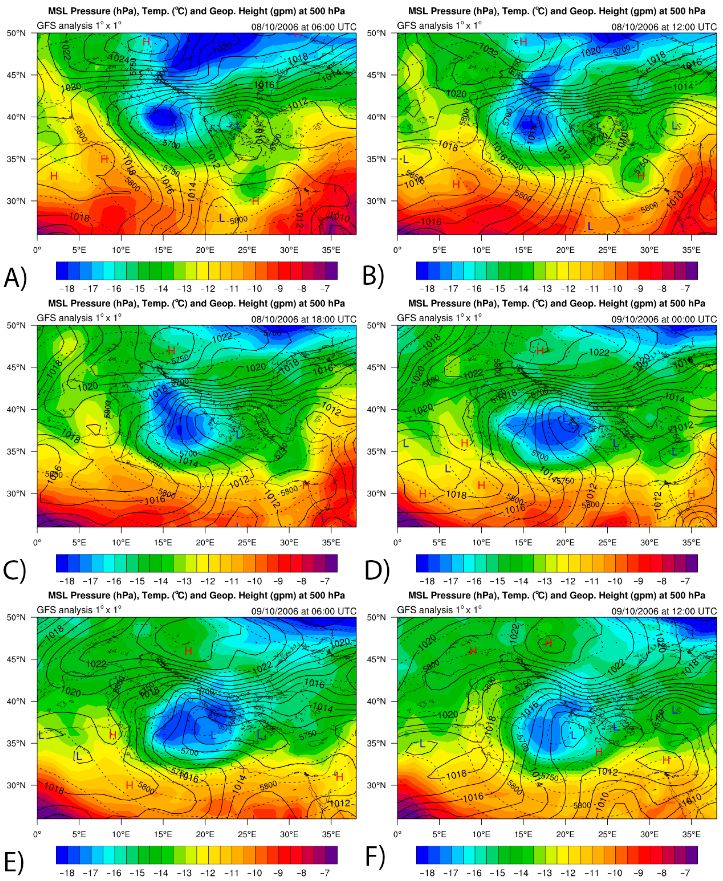
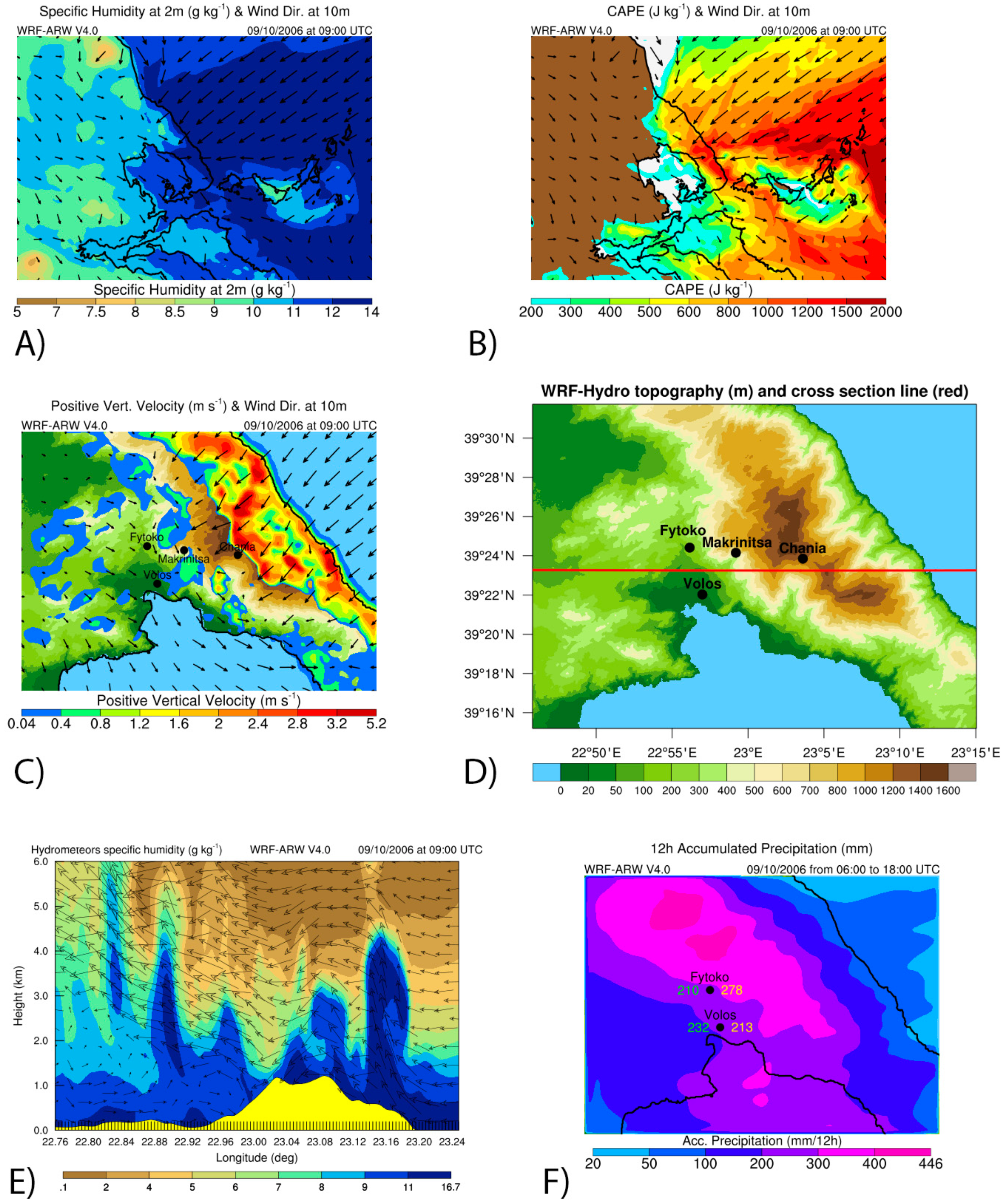
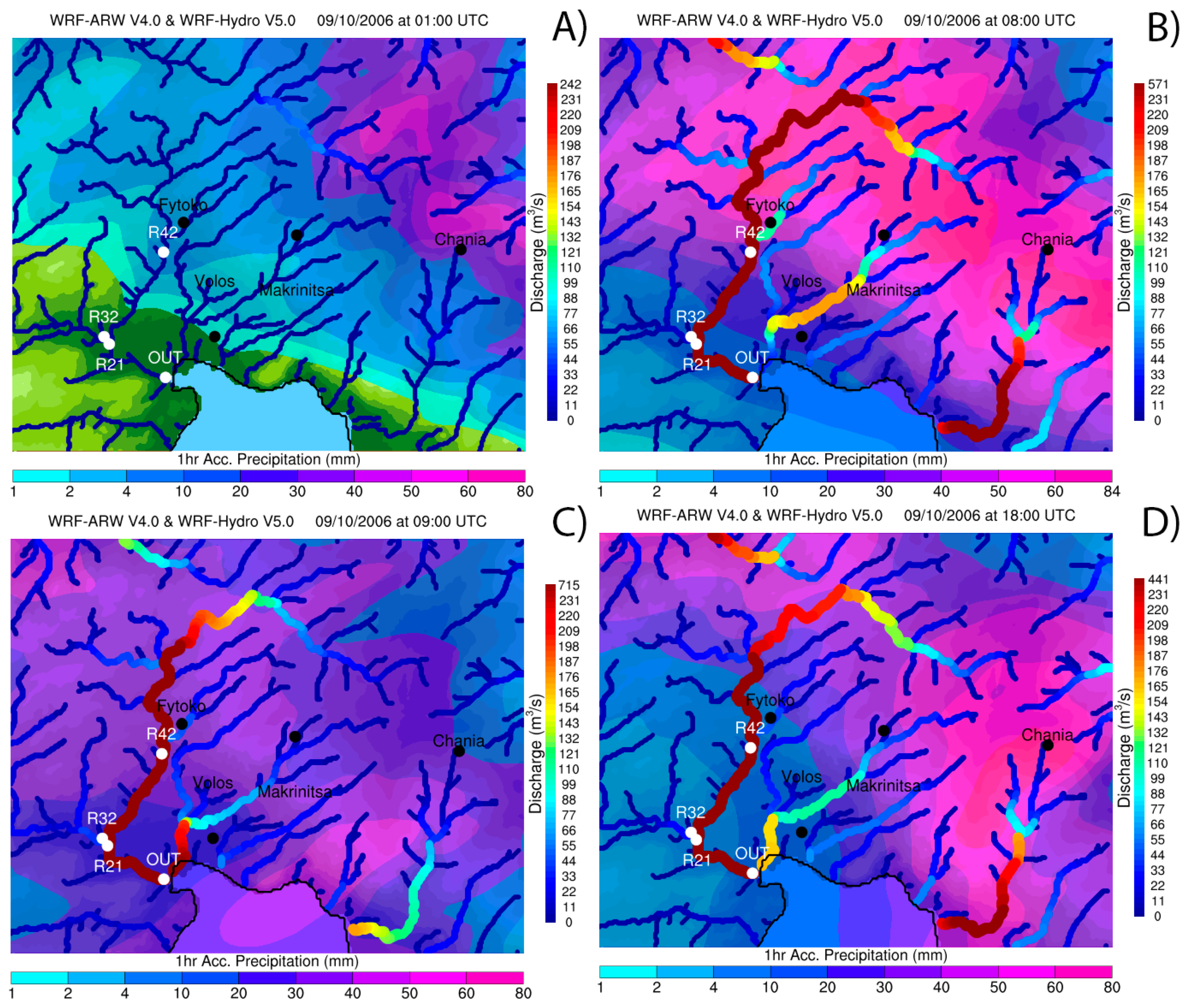
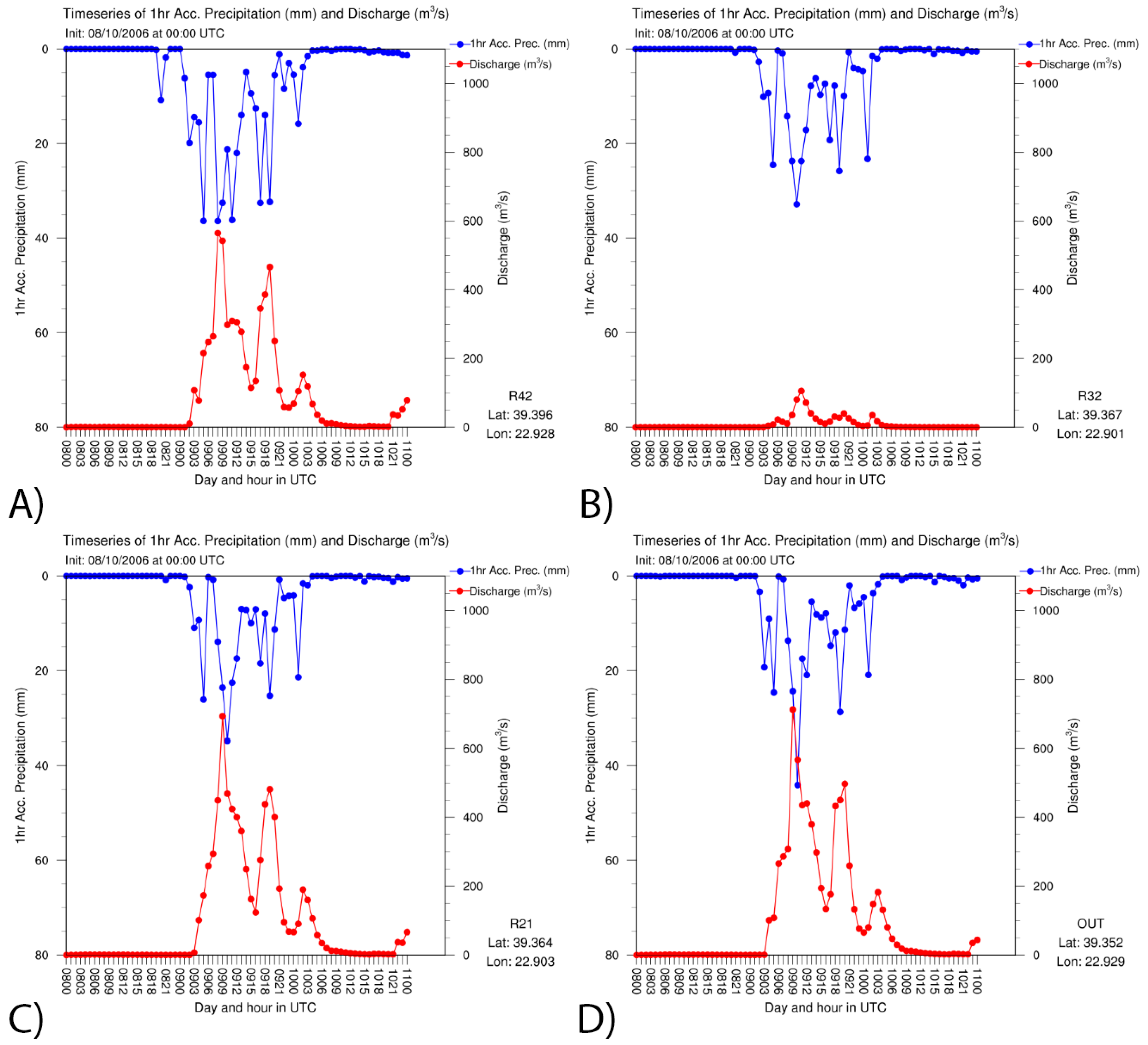
3.1. Hydrometeorological Analysis
3.2. Hydraulic Simulation Results
4. Concluding Remarks
Author Contributions
Funding
Acknowledgments
Conflicts of Interest
References
- Centre for Research on the Epidemiology of Disasters (CRED). Summarized Table of Natural Disasters in Europe from 1900 to 2019, EM-DAT: The CRED/OFDA International Disaster Database–www.emdat.be–Université Catholique de Louvain–Brussels–Belgium. Available online: http://www.emdat.be (accessed on 31 July 2019).
- Gangrade, S.; Kao, S.C.; Dullo, T.T.; Kalyanapu, A.J.; Preston, B.L. Ensemble-Based flood vulnerability assessment for probable maximum flood in a changing environment. J. Hydrol. 2019, 576, 342–355. [Google Scholar] [CrossRef]
- Hall, J.; Arheimer, B.; Borga, M.; Brázdil, R.; Claps, P.; Kiss, A.; Kjeldsen, T.R.; Kriaučiūnienė, J.; Kundzewicz, Z.W.; Lang, M.; et al. Understanding flood regime changes in Europe: A state-of-the-art assessment. Hydrol. Earth Syst. Sci. 2014, 18, 2735–2772. [Google Scholar] [CrossRef]
- Zeleňáková, M.; Gaňová, L.; Purcz, P.; Horský, M.; Satrapa, L.; Blišťan, P.; Diaconu, D.C. Mitigation of the Adverse Consequences of Floods for Human Life, Infrastructure, and the Environment. Nat. Hazards Rev. 2017, 18, 1–15. [Google Scholar] [CrossRef]
- Papaioannou, G.; Efstratiadis, A.; Vasiliades, L.; Loukas, A.; Papalexiou, S.; Koukouvinos, A.; Tsoukalas, I.; Kossieris, P. An Operational Method for Flood Directive Implementation in Ungauged Urban Areas. Hydrology 2018, 5, 24. [Google Scholar] [CrossRef]
- Papaioannou, G.; Loukas, A.; Vasiliades, L.; Aronica, G.T. Flood inundation mapping sensitivity to riverine spatial resolution and modelling approach. Nat. Hazards 2016, 83, 117–132. [Google Scholar] [CrossRef]
- Macchione, F.; Costabile, P.; Costanzo, C.; De Lorenzo, G. Extracting quantitative data from non-conventional information for the hydraulic reconstruction of past urban flood events. A case study. J. Hydrol. 2019, 576, 443–465. [Google Scholar] [CrossRef]
- Aronica, G.T.; Franza, F.; Bates, P.D.; Neal, J.C. Probabilistic evaluation of flood hazard in urban areas using Monte Carlo simulation. Hydrol. Process. 2012, 26, 3962–3972. [Google Scholar] [CrossRef]
- Kiczko, A.; Mirosław-Świątek, D. Impact of Uncertainty of Floodplain Digital Terrain Model on 1D Hydrodynamic Flow Calculation. Water 2018, 10, 1308. [Google Scholar] [CrossRef]
- Papaioannou, G. Flood Hazard and Risk Modelling Framework for Ungauged Streams and Watersheds; University of Thessaly: Volos, Greece, 2017. [Google Scholar]
- Teng, J.; Jakeman, A.J.; Vaze, J.; Croke, B.F.W.; Dutta, D.; Kim, S. Flood inundation modelling: A review of methods, recent advances and uncertainty analysis. Environ. Model. Softw. 2017, 90, 201–216. [Google Scholar] [CrossRef]
- Apel, H.; Aronica, G.T.; Kreibich, H.; Thieken, A.H. Flood risk analyses—How detailed do we need to be? Nat. Hazards 2009, 49, 79–98. [Google Scholar] [CrossRef]
- Varlas, G.; Anagnostou, M.N.; Spyrou, C.; Papadopoulos, A.; Kalogiros, J.; Mentzafou, A.; Michaelides, S.; Baltas, E.; Karymbalis, E.; Katsafados, P. A multi-platform hydrometeorological analysis of the flash flood event of 15 November 2017 in Attica, Greece. Remote Sens. 2019, 11, 45. [Google Scholar] [CrossRef]
- Skamarock, W.C.; Klemp, J.B.; Dudhia, J.; Gill, D.O.; Barker, D.M.; Duda, M.G.; Huang, X.-Y.; Wang, W.; Powers, J.G. A Description of the Advanced Research WRF Version 3. NCAR Tech. NOTE—NCAR/TN-475+STR; UCAR: Boulder, CO, USA, 2008; Volume 125. [Google Scholar] [CrossRef]
- Powers, J.G.; Klemp, J.B.; Skamarock, W.C.; Davis, C.A.; Dudhia, J.; Gill, D.O.; Coen, J.L.; Gochis, D.J.; Ahmadov, R.; Peckham, S.E.; et al. The weather research and forecasting model: Overview, system efforts, and future directions. Bull. Am. Meteorol. Soc. 2017, 98, 1717–1737. [Google Scholar] [CrossRef]
- Gochis, D.J.; Barlage, M.; Dugger, A.; Fitzgerald, K.; Karsten, L.; McAllister, M.; McCreight, J.; Mills, J.; RafieeiNasab, A.; Read, L.; et al. The WRF-Hydro modeling system technical description (Version 5.0); NCAR Technical Note; National Center for Atmospheric Research: Boulder, CO, USA, 2018; p. 107. [Google Scholar]
- Senatore, A.; Mendicino, G.; Gochis, D.J.; Yu, W.; Yates, D.N.; Kunstmann, H. Fully coupled atmosphere-hydrology simulations for the central Mediterranean: Impact of enhanced hydrological parameterization for short and long time scales. J. Adv. Model. Earth Syst. 2015, 7, 1693–1715. [Google Scholar] [CrossRef]
- Silvestro, F.; Rossi, L.; Campo, L.; Parodi, A.; Fiori, E.; Rudari, R.; Ferraris, L. Impact-Based flash-flood forecasting system: Sensitivity to high resolution numerical weather prediction systems and soil moisture. J. Hydrol. 2019, 572, 388–402. [Google Scholar] [CrossRef]
- Givati, A.; Gochis, D.; Rummler, T.; Kunstmann, H. Comparing One-Way and Two-Way Coupled Hydrometeorological Forecasting Systems for Flood Forecasting in the Mediterranean Region. Hydrology 2016, 3, 19. [Google Scholar] [CrossRef]
- Sanz-Ramos, M.; Amengual, A.; Bladé, E.; Romero, R.; Roux, H. Flood forecasting using a coupled hydrological and hydraulic model (based on FVM) and highresolution meteorological model. EDP Sciences 2018, 40, 1–8. [Google Scholar] [CrossRef]
- Zhu, X.; Dai, Q.; Han, D.; Zhuo, L.; Zhu, S.; Zhang, S. Modeling the high-resolution dynamic exposure to flooding in a city region. Hydrol. Earth Syst. Sci. 2019, 23, 3353–3372. [Google Scholar] [CrossRef] [Green Version]
- Afifi, Z.; Chu, H.J.; Kuo, Y.L.; Hsu, Y.C.; Wong, H.K.; Ali, M.Z. Residential flood loss assessment and risk mapping from high-resolution simulation. Water (Switzerland) 2019, 11, 751. [Google Scholar] [CrossRef]
- Langhammer, J.; Lendzioch, T.; Miřijovskỳ, J.; Hartvich, F. UAV-Based optical granulometry as tool for detecting changes in structure of flood depositions. Remote Sens. 2017, 9, 240. [Google Scholar] [CrossRef]
- Kiczko, A.; Romanowicz, R.J.; Osuch, M.; Karamuz, E. Maximising the usefulness of flood risk assessment for the river Vistula in Warsaw. Nat. Hazards Earth Syst. Sci. 2013, 13, 3443–3455. [Google Scholar] [CrossRef]
- Jalayer, F.; Aronica, G.T.; Recupero, A.; Carozza, S.; Manfredi, G. Debris flow damage incurred to buildings: An in situ back analysis. J. Flood Risk Manag. 2018, 11, S646–S662. [Google Scholar] [CrossRef]
- Gourley, J.J.; Flamig, Z.L.; Vergara, H.; Kirstetter, P.E.; Clark, R.A.; Argyle, E.; Arthur, A.; Martinaitis, S.; Terti, G.; Erlingis, J.M.; et al. The flash project Improving the Tools for Flash Flood Monitoring and Prediction across the United States. Bull. Am. Meteorol. Soc. 2017, 98, 361–372. [Google Scholar] [CrossRef]
- Martinaitis, S.M.; Gourley, J.J.; Flamig, Z.L.; Argyle, E.M.; Clark, R.A.; Arthur, A.; Smith, B.R.; Erlingis, J.M.; Perfater, S.; Albright, B. The hmt multi-radar multi-sensor hydro experiment. Bull. Am. Meteorol. Soc. 2017, 98, 347–359. [Google Scholar] [CrossRef]
- Gaume, E.; Borga, M. Post-Flood field investigations in upland catchments after major flash floods: Proposal of a methodology and illustrations. J. Flood Risk Manag. 2008, 1, 175–189. [Google Scholar] [CrossRef]
- Brunner, G.W. CEIWR-HEC HEC-RAS River Analysis System 2D Modeling User’s Manual; US Army Corps of Engineers—Hydrologic Engineering Center: Davis, CA, USA, 2016. [Google Scholar]
- Koutsogiannis, D.; Markonis, I. Hydrological Analysis of Xerias River Basin, Magnesia—Flood Works Report of Xerias, Seskouliotis and Kakaviotis Streams; Magnesia Prefectural Authority and Mahairas Technical Consultant Company: Athens, Greece, 2010. (in Greek) [Google Scholar]
- Hellenic Statistical Authority. 2011 POPULATION AND HOUSING CENSUS Demographic and Social Characteristics of the Resident Population of Greece according to the 2011 Population—Housing Census Revision of 20/3/2014; Hellenic Statistical Authority: Piraeus, Greece, 2014. [Google Scholar]
- Diakakis, M.; Mavroulis, S.; Deligiannakis, G. Floods in Greece, a statistical and spatial approach. Nat. Hazards 2012, 62, 485–500. [Google Scholar] [CrossRef]
- Special Secretariat for Water, M. of E. and E. (SSW-M. Preliminary Assessment of the Flood Directive; Athens: Ministry of Environment and Energy. Available online: http://www.ypeka.gr/Lin%0AkClick.aspx?fileticket=T4DDG1hqQMY%3D&tabid=252&language=el-GR%0A (accessed on 1 July 2019).
- Papaioannou, G.; Vasiliades, L.; Loukas, A. Multi-Criteria Analysis Framework for Potential Flood Prone Areas Mapping. Water Resour. Manag. 2015, 29, 399–418. [Google Scholar] [CrossRef]
- Papaioannou, G. Sensitivity analysis of a probabilistic flood inundation mapping framework for ungauged catchments. Eur. Water 2017, 9–16. [Google Scholar]
- Shepherd, M.; Mote, T.; Dowd, J.; Roden, M.; Knox, P.; McCutcheon, S.C.; Nelson, S.E. An overview of synoptic and mesoscale factors contributing to the disastrous Atlanta flood of 2009. Bull. Am. Meteorol. Soc. 2011, 92, 861–870. [Google Scholar] [CrossRef]
- Varlas, G.; Papadopoulos, A.; Katsafados, P. An analysis of the synoptic and dynamical characteristics of hurricane Sandy (2012). Meteorol. Atmos. Phys. 2018, 131, 1–11. [Google Scholar] [CrossRef]
- Katsafados, P.; Varlas, G.; Papadopoulos, A.; Spyrou, C.; Korres, G. Assessing the Implicit Rain Impact on Sea State During Hurricane Sandy (2012). Geophys. Res. Lett. 2018, 45, 12015–12022. [Google Scholar] [CrossRef]
- Christakos, K.; Varlas, G.; Reuder, J.; Katsafados, P.; Papadopoulos, A. Analysis of a low-level coastal jet off the Western coast of Norway. Energy Procedia 2014, 53, 162–172. [Google Scholar] [CrossRef]
- Christakos, K.; Cheliotis, I.; Varlas, G.; Steeneveld, G.J. Offshore Wind Energy Analysis of Cyclone Xaver over North Europe. Energy Procedia 2016, 94, 37–44. [Google Scholar] [CrossRef] [Green Version]
- Varlas, G.; Katsafados, P.; Papadopoulos, A.; Korres, G. Implementation of a two-way coupled atmosphere-ocean wave modeling system for assessing air-sea interaction over the Mediterranean Sea. Atmos. Res. 2018, 208, 201–217. [Google Scholar] [CrossRef]
- Varlas, G.; Katsafados, P.; Korres, G.; Papadopoulos, A. Assessing the impact of Argo floats temperature measurements on the numerical weather prediction forecast skill of a weather prediction numerical model. Mediterr. Mar. Sci. 2019, 20, 331–334. [Google Scholar] [CrossRef]
- Cheliotis, I.; Varlas, G.; Christakos, K. The Impact of Cyclone Xaver on Hydropower Potential in Norway. In Perspectives on Atmospheric Sciences; Karacostas, T., Bais, A., Nastos, P.T., Eds.; Springer International Publishing: Cham, Switzerland, 2017; pp. 175–181. ISBN 978-3-319-35095-0. [Google Scholar]
- Harats, N.; Ziv, B.; Yair, Y.; Kotroni, V.; Dayan, U. Lightning and rain dynamic indices as predictors for flash floods events in the Mediterranean. Adv. Geosci. 2010, 23, 57–64. [Google Scholar] [CrossRef] [Green Version]
- Creutin, J.D.; Borga, M.; Gruntfest, E.; Lutoff, C.; Zoccatelli, D.; Ruin, I. A space and time framework for analyzing human anticipation of flash floods. J. Hydrol. 2013, 482, 14–24. [Google Scholar] [CrossRef]
- Danielson, J.J.; Gesch, D.B. Global multi-resolution terrain elevation data 2010 (GMTED2010); US Geological Survey: Reston, VA, USA, 2011.
- Myneni, R.; Hoffman, S.; Knyazikhin, Y. Global products of vegetation leaf area and fraction absorbed PAR from one year of MODIS data. Remote Sensing of. Environment 2002, 76, 139–155. [Google Scholar]
- Friedl, M.A.; Sulla-Menashe, D.; Tan, B.; Schneider, A.; Ramankutty, N.; Sibley, A.; Huang, X. MODIS Collection 5 global land cover: Algorithm refinements and characterization of new datasets. Remote Sens. Environ. 2010, 114, 168–182. [Google Scholar] [CrossRef]
- Hong, S.-Y.; Noh, Y.; Dudhia, J. A New Vertical Diffusion Package with an Explicit Treatment of Entrainment Processes. Mon. Weather Rev. 2006, 134, 2318–2341. [Google Scholar] [CrossRef] [Green Version]
- Jiménez, P.A.; Dudhia, J.; González-Rouco, J.F.; Navarro, J.; Montávez, J.P.; García-Bustamante, E. A Revised Scheme for the WRF Surface Layer Formulation. Mon. Weather Rev. 2011, 140, 898–918. [Google Scholar] [CrossRef]
- Tewari, M.; Chen, F.; Wang, W.; Dudhia, J.; LeMone, M.A.; Mitchell, K.; Ek, M.; Gayno, G.; Wegiel, J.; Cuenca, R.H. Implementation and verification of the unified Noah land surface model in the WRF model. In Proceedings of the 20th Conference on Weather Analysis and Forecasting/16th Conference on Numerical Weather Prediction, Seattle, WA, USA, 12–16 January 2004; pp. 2165–2170. [Google Scholar]
- Iacono, M.J.; Delamere, J.S.; Mlawer, E.J.; Shephard, M.W.; Clough, S.A.; Collins, W.D. Radiative forcing by long-lived greenhouse gases: Calculations with the AER radiative transfer models. J. Geophys. Res. Atmos. 2008, 113, 2–9. [Google Scholar] [CrossRef]
- Thompson, G.; Field, P.R.; Rasmussen, R.M.; Hall, W.D. Explicit Forecasts of Winter Precipitation Using an Improved Bulk Microphysics Scheme. Part II: Implementation of a New Snow Parameterization. Mon. Weather Rev. 2008, 136, 5095–5115. [Google Scholar] [CrossRef]
- Grell, G.A.; Freitas, S.R. A scale and aerosol aware stochastic convective parameterization for weather and air quality modeling. Atmos. Chem. Phys. 2014, 14, 5233–5250. [Google Scholar] [CrossRef] [Green Version]
- Yucel, I.; Onen, A.; Yilmaz, K.K.; Gochis, D.J. Calibration and evaluation of a flood forecasting system: Utility of numerical weather prediction model, data assimilation and satellite-based rainfall. J. Hydrol. 2015, 523, 49–66. [Google Scholar] [CrossRef] [Green Version]
- Maidment, D.R. Conceptual Framework for the National Flood Interoperability Experiment. J. Am. Water Resour. Assoc. 2017, 53, 245–257. [Google Scholar] [CrossRef]
- Jarvis, A.; Reuter, H.I.; Nelson, A.; Guevara, E. Hole-Filled SRTM for the globe Version 4, available from the CGIAR-CSI SRTM 90m Database. Available online: http://srtm.csi.cgiar.org (accessed on 1 July 2019).
- Lehner, B.; Verdin, K.; Jarvis, A. New Global Hydrography Derived From Spaceborne Elevation Data. Eos Trans. Am. Geophys. Union 2008, 89, 93. [Google Scholar] [CrossRef]
- Dottori, F.; Di Baldassarre, G.; Todini, E. Detailed data is welcome, but with a pinch of salt: Accuracy, precision, and uncertainty in flood inundation modeling. Water Resour. Res. 2013, 49, 6079–6085. [Google Scholar] [CrossRef]
- Brunner, G.W. CEIWR-HHT Benchmarking of the HEC-RAS Two-Dimensional Hydraulic Modeling Capabilities; US Army Corps of Engineers—Hydrologic Engineering Center: Davis, CA, USA, 2018. [Google Scholar]
- Brunner, G.W.; Sanchez, A.; Molls, T.; Parr, D.A. HEC-RAS Verification and Validation Tests; US Army Corps of Engineers–Hydrologic Engineering Center: Davis, CA, USA, 2018; pp. 1–154. [Google Scholar]
- Leitão, J.P.; de Sousa, L.M. Towards the optimal fusion of high-resolution Digital Elevation Models for detailed urban flood assessment. J. Hydrol. 2018, 561, 651–661. [Google Scholar] [CrossRef]
- Bhuyian, M.N.M.; Kalyanapu, A. Accounting digital elevation uncertainty for flood consequence assessment. J. Flood Risk Manag. 2018, 11, S1051–S1062. [Google Scholar] [CrossRef]
- Bates, P.D.; De Roo, A.P.J. A simple raster-based model for flood inundation simulation. J. Hydrol. 2000, 236, 54–77. [Google Scholar] [CrossRef]
- Bharath, R.; Elshorbagy, A. Flood mapping under uncertainty: A case study in the Canadian prairies. Nat. Hazards 2018, 94, 537–560. [Google Scholar] [CrossRef]
- Liu, Z.; Merwade, V. Accounting for model structure, parameter and input forcing uncertainty in flood inundation modeling using Bayesian model averaging. J. Hydrol. 2018, 565, 138–149. [Google Scholar] [CrossRef]
- Dimitriadis, P.; Tegos, A.; Oikonomou, A.; Pagana, V.; Koukouvinos, A.; Mamassis, N.; Koutsoyiannis, D.; Efstratiadis, A. Comparative evaluation of 1D and quasi-2D hydraulic models based on benchmark and real-world applications for uncertainty assessment in flood mapping. J. Hydrol. 2016, 534, 478–492. [Google Scholar] [CrossRef]
- Schubert, J.E.; Sanders, B.F. Building treatments for urban flood inundation models and implications for predictive skill and modeling efficiency. Adv. Water Resour. 2012, 41, 49–64. [Google Scholar] [CrossRef]
- Bellos, V.; Tsakiris, G. Comparing Various Methods of Building Representation for 2D Flood Modelling In Built-Up Areas. Water Resour. Manag. 2015, 29, 379–397. [Google Scholar] [CrossRef]
- Shen, J.; Tan, F.; Zhang, Y. Improved building treatment approach for urban inundation modeling: A case study in Wuhan, China. Water (Switzerland) 2018, 10, 1760. [Google Scholar] [CrossRef]
- Palla, A.; Colli, M.; Candela, A.; Aronica, G.T.; Lanza, L.G. Pluvial flooding in urban areas: The role of surface drainage efficiency. J. Flood Risk Manag. 2018, 11, S663–S676. [Google Scholar] [CrossRef]
- Bermúdez, M.; Zischg, A.P. Sensitivity of flood loss estimates to building representation and flow depth attribution methods in micro-scale flood modelling. Nat. Hazards 2018, 92, 1633–1648. [Google Scholar] [CrossRef] [Green Version]
- Papaioannou, G.; Vasiliades, L.; Loukas, A.; Aronica, G.T. Probabilistic flood inundation mapping at ungauged streams due to roughness coefficient uncertainty in hydraulic modelling. Adv. Geosci. 2017, 44, 23–34. [Google Scholar] [CrossRef] [Green Version]
- Kotroni, V.; Lagouvardos, K.; Defer, E.; Dietrich, S.; Porcù, F.; Medaglia, C.M.; Demirtas, M. The Antalya 5 December 2002 Storm: Observations and Model Analysis. J. Appl. Meteorol. Climatol. 2006, 45, 576–590. [Google Scholar] [CrossRef]
- Porcù, F.; Carrassi, A.; Medaglia, C.M.; Prodi, F.; Mugnai, A. A study on cut-off low vertical structure and precipitation in the Mediterranean region. Meteorol. Atmos. Phys. 2007, 96, 121–140. [Google Scholar] [CrossRef]
- Becker, J.S.; Taylor, H.L.; Doody, B.J.; Wright, K.C.; Gruntfest, E.; Webber, D. A review of people’s behavior in and around floodwater. Weather. Clim. Soc. 2015, 7, 321–332. [Google Scholar] [CrossRef]
- Terti, G.; Ruin, I.; Anquetin, S.; Gourley, J.J. A situation-based analysis of flash flood fatalities in the United States. Bull. Am. Meteorol. Soc. 2017, 98, 333–345. [Google Scholar] [CrossRef]
- Petrucci, O.; Papagiannaki, K.; Aceto, L.; Boissier, L.; Kotroni, V.; Grimalt, M.; Llasat, M.C.; Llasat-Botija, M.; Rosselló, J.; Pasqua, A.A.; et al. MEFF: The database of MEditerranean Flood Fatalities (1980 to 2015). J. Flood Risk Manag. 2019, 12, 1–17. [Google Scholar] [CrossRef]
- European Environment Agency. Urban Adaptation to Climate Change in Europe—Challenges and Opportunities for Cities Together with Supportive National and European Policies; European Environment Agency: Copenhagen, Danmark, 2012. [Google Scholar]
- Terti, G.; Ruin, I.; Gourley, J.J.; Kirstetter, P.; Flamig, Z.; Blanchet, J.; Arthur, A.; Anquetin, S. Toward Probabilistic Prediction of Flash Flood Human Impacts. Risk Anal. 2019, 39, 140–161. [Google Scholar] [CrossRef]
| Meteorological Forcing Fields | Units |
|---|---|
| Incoming shortwave radiation (SR) | (W m−2) |
| Incoming longwave radiation (LR) | (W m−2) |
| Air specific humidity at 2 m (Q2) | (kg kg−1) |
| Air temperature at 2 m (T2) | (K) |
| Atmospheric pressure at surface (PSFC) | (Pa) |
| Near surface wind at 10 m in the u- and v-components (U10, V10) | (m s−1) |
| Liquid water precipitation rate (PREC) | (mm s−1) |
| LABEL3 | Manning’s n |
|---|---|
| 1.1.1 Continuous urban fabric | 0.013 |
| 1.1.2 Discontinuous urban fabric | |
| 1.2.1 Industrial or commercial units | 0.013 |
| 1.2.3 Port areas | |
| 1.3.1 Mineral extraction sites | 0.013 |
| 1.3.3 Construction sites | |
| 2.2.2 Fruit trees and berry plantations | 0.08 |
| 2.2.3 Olive groves | |
| 2.4.2 Complex cultivation patterns | 0.04 |
| 2.4.3 Land principally occupied by agriculture, with significant areas of natural vegetation | 0.05 |
| 3.2.1 Natural grasslands | 0.04 |
| 3.2.3 Sclerophyllous vegetation | 0.05 |
| Junction | Maximum Discharge (m3 s−1) Values | ||
|---|---|---|---|
| WRF Hydrograph | Clark IUH | Design Hydrograph | |
| R42 | 564.6 | 490.43 | 385.72 |
| R32 | 105.2 | 204.41 | 160.79 |
| R21 | 692.8 | 681.89 | 536.31 |
| Validation Points within the Flooded Area | Flood Hydrographs | ||
|---|---|---|---|
| WRF Hydrograph | Clark IUH | Design Hydrograph | |
| Number of points | 3559 | 3367 | 2456 |
| Percentage (%) | 84 | 79 | 58 |
© 2019 by the authors. Licensee MDPI, Basel, Switzerland. This article is an open access article distributed under the terms and conditions of the Creative Commons Attribution (CC BY) license (http://creativecommons.org/licenses/by/4.0/).
Share and Cite
Papaioannou, G.; Varlas, G.; Terti, G.; Papadopoulos, A.; Loukas, A.; Panagopoulos, Y.; Dimitriou, E. Flood Inundation Mapping at Ungauged Basins Using Coupled Hydrometeorological–Hydraulic Modelling: The Catastrophic Case of the 2006 Flash Flood in Volos City, Greece. Water 2019, 11, 2328. https://doi.org/10.3390/w11112328
Papaioannou G, Varlas G, Terti G, Papadopoulos A, Loukas A, Panagopoulos Y, Dimitriou E. Flood Inundation Mapping at Ungauged Basins Using Coupled Hydrometeorological–Hydraulic Modelling: The Catastrophic Case of the 2006 Flash Flood in Volos City, Greece. Water. 2019; 11(11):2328. https://doi.org/10.3390/w11112328
Chicago/Turabian StylePapaioannou, George, George Varlas, Galateia Terti, Anastasios Papadopoulos, Athanasios Loukas, Yiannis Panagopoulos, and Elias Dimitriou. 2019. "Flood Inundation Mapping at Ungauged Basins Using Coupled Hydrometeorological–Hydraulic Modelling: The Catastrophic Case of the 2006 Flash Flood in Volos City, Greece" Water 11, no. 11: 2328. https://doi.org/10.3390/w11112328
APA StylePapaioannou, G., Varlas, G., Terti, G., Papadopoulos, A., Loukas, A., Panagopoulos, Y., & Dimitriou, E. (2019). Flood Inundation Mapping at Ungauged Basins Using Coupled Hydrometeorological–Hydraulic Modelling: The Catastrophic Case of the 2006 Flash Flood in Volos City, Greece. Water, 11(11), 2328. https://doi.org/10.3390/w11112328


