The Study of the Coastal Management Criteria Based on Risk Assessmeant: A Case Study on Yunlin Coast, Taiwan


Abstract
:1. Introduction
2. Background
2.1. Coastal Protection Areas in Taiwan
2.2. Coastal Protection Strategies
3. Methodology
- Adopt indicators that can be obtained from accessible databases, or use simple statistical analyses that satisfy the spatial unit and accuracy requirements.
- To ensure data impartiality, data or research projects announced or published by public institutions or government authorities are to be prioritized.
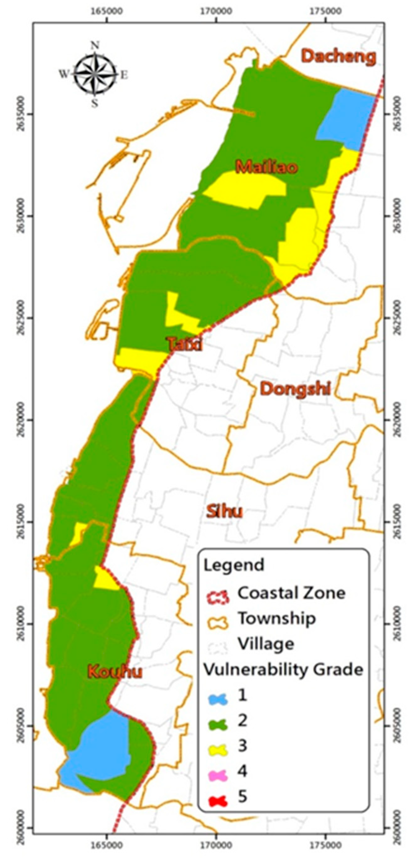
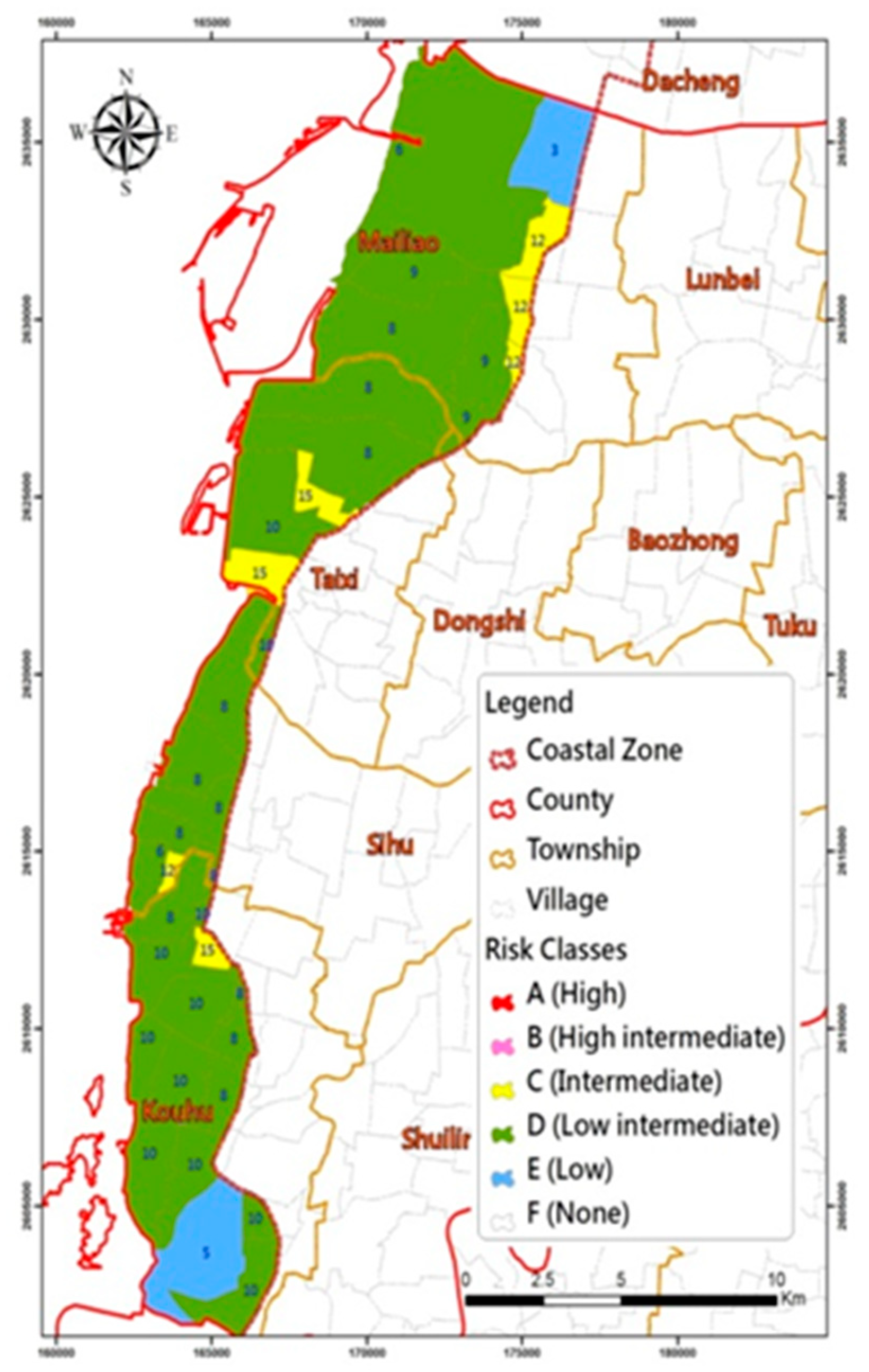
4. Results
4.1. Formulation of Design Criteria
4.2. Design Criteria for Coastal Defense and Land Use
- High risk level (level A): marine conditions (including waves and surges) in a 100-year return period were adopted as the design criteria.
- High-intermediate risk level (level B): a 50–100 year return period was adopted as the design criterion. However, to avoid any negative environmental impact caused by design criteria upgrades, the original design criterion is still considered applicable for coastal defenses meeting the criteria of a 50-year return period, if modifying the coastal defenses (structural measures) or extending the buffer zone (nonstructural measures) enables the coastal defense to reduce external impact sufficiently for the original design criterion to withstand it.
- Moderate risk level (level C): a 50-year return period was adopted as the design criterion.
- Low-intermediate risk level (level D): a 25–50 year return period was adopted as the design criterion. As above, to prevent any negative environmental impact caused by upgrading design criteria, the original design criterion was still considered applicable if other supportive measures can reduce external impact sufficiently for the original design criterion to withstand it.
- Low risk level (level E): a 25-year return period was adopted as the design criterion.
- Minimal risk level (level F): no protection facility is required.
5. Discussion
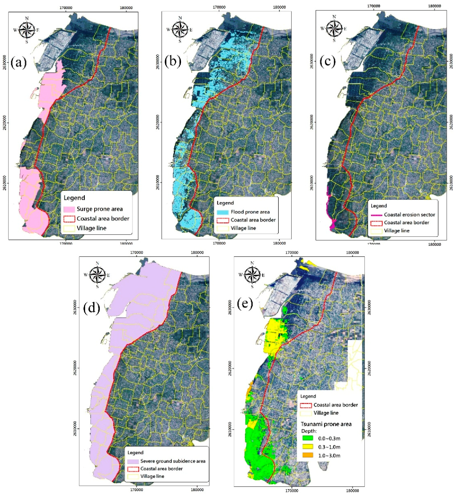
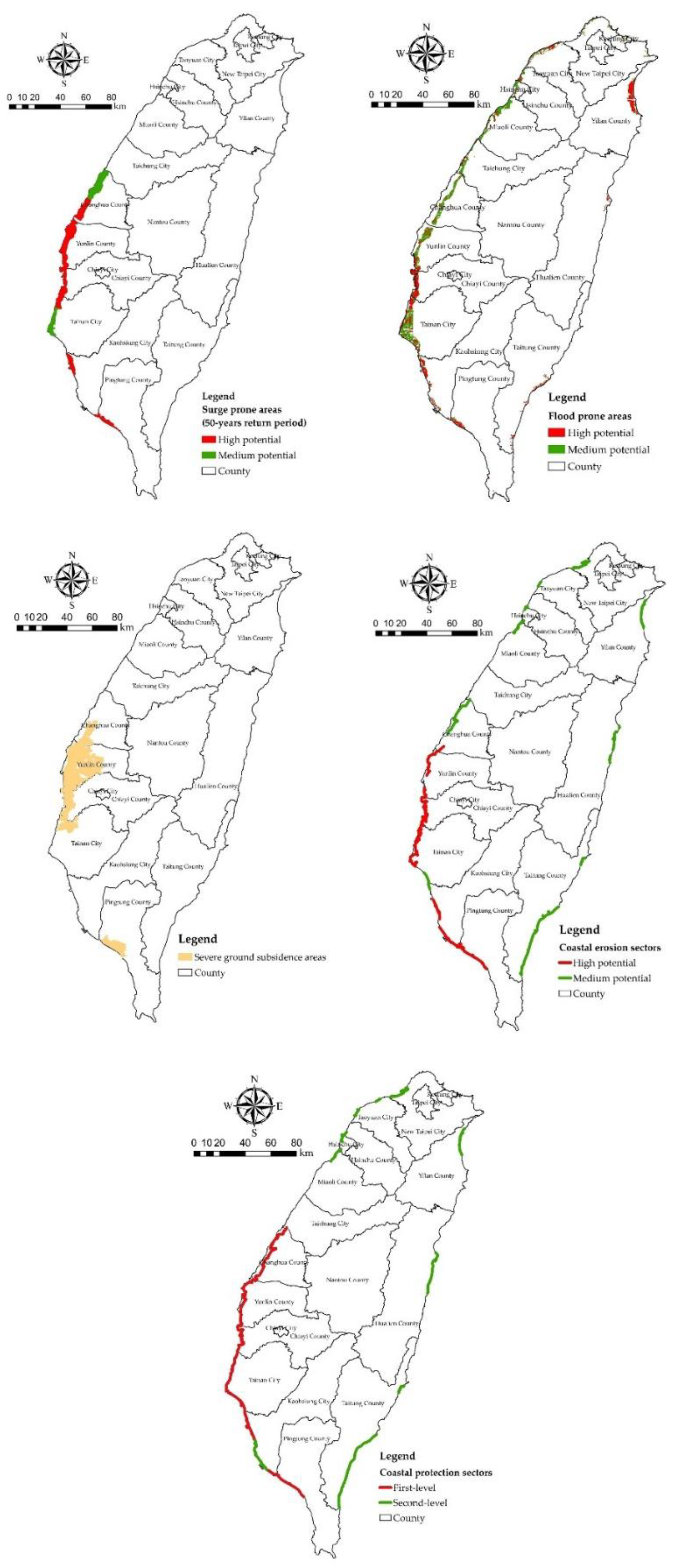
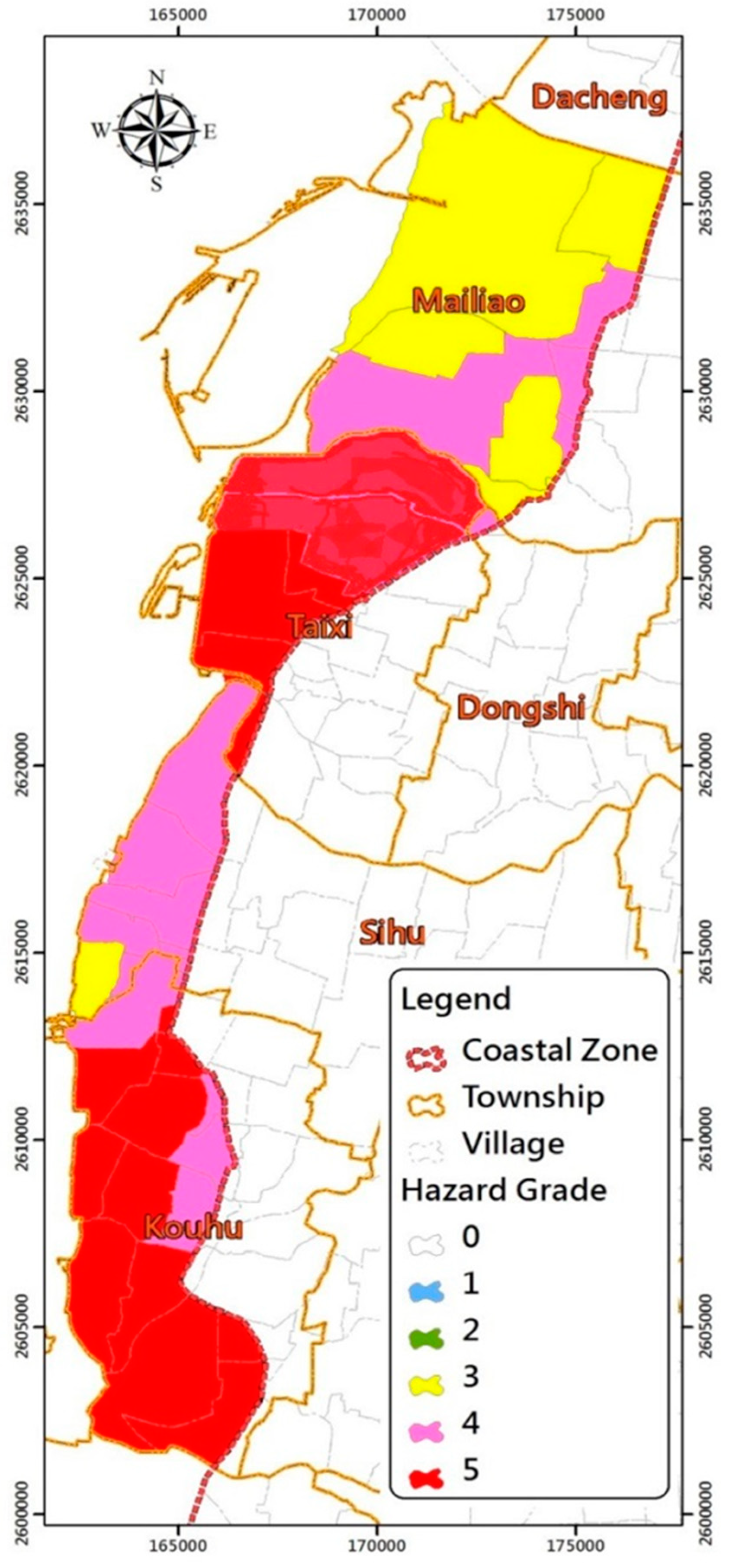
- Storm surges: The 50-year return period of storm surge height along the Yunlin coast is +2.64 m, based on “The Assessment on Coastal Protection of Sea Dikes” plan (Water Resources Planning Institute (WRPI), 2014) [44]. The design codes proposed in this plan were applied by the River Management Offices to assess the safety and capability of currently existing sea walls. Areas with potential inundation depths greater than 1 m were estimated based on storm surge water levels and land elevation. The criterion of having an inundation depth of 1 m or more is given in Table 1, which defines the severity of coastal hazards where inundation may cause danger to life. As the height of the sea wall throughout the areas studied is greater than the potential storm surge heights, the extent of inundation-prone areas was estimated with the assumption that there were no sea walls in the area. The Taixi and Kouhu Townships were estimated to be the areas that most prone to surge hazards (Figure 4a).
- Coastal erosion: The erosion coastlines of Yunlin County were estimated using data from the historical bathymetry survey. The coastline of Kouhu Township was found to be subject to coastal erosion (Figure 4c).
- Tsunami: Areas under potential tsunami threats were studied by the NCDR (2015) [43]. The results were derived from the numerical simulations of 600 scenarios. Eighteen possible epicenters of earthquakes distributed in the oceans around Taiwan were considered. These include the Manila trench, one of the most hazardous tsunami source regions. The maximum possible earthquake scenarios within these trenches and troughs were considered. The areas that can be potentially affected by tsunamis in Yunlin County have a similar distribution to storm surge inundation areas. Essentially, Taixi and Kouhou Townships were estimated to be most prone to tsunami hazards (Figure 4e).
5.1. Non-Engineering Measures
5.2. Public Participation
6. Conclusions
Author Contributions
Acknowledgments
Conflicts of Interest
References
- Huang, W.P.; Chien, L.K.; Lee, L.H. Risk Maps and Coastal Defense Criteria in Taiwan. J. Mar. Sci. Technol. 2016, 24, 1105–1114. [Google Scholar]
- Chien, L.K.; Hsu, C.H.; Huang, W.P.; Wang, I.C. The Study of Designation of Coastal Protection Zone and Management in Taiwan. In Proceedings of the Twenty-Sixth International Ocean and Polar Engineering Conference, Rhodes, Greece, 26 June–2 July 2016; pp. 1287–1293. [Google Scholar]
- United Nations Disaster Relief Organization (UNDRO). Natural Disasters and Vulnerability Analysis; Report of Experts Group Meeting; UNDRO: Geneva, Switzerland, 1980. [Google Scholar]
- Chien, L.K.; Chiu, S.Y.; Tseng, W.C.; Hsu, C.H. The Study of Coastal Risk Assessment of Planning and Management for Coastal Area in Taiwan. In Proceedings of the Twenty-Second International Offshore and Polar Engineering Conference, Rhodes, Greece, 17–22 June 2012; pp. 17–22. [Google Scholar]
- McCarthy, M.A.; Possingham, H.P.; Day, J.R.; Tyre, A.J. Testing the accuracy of population viability analysis. Conserv. Biol. 2001, 15, 1030–1038. [Google Scholar] [CrossRef]
- Van der Veen, A.; Logtmeijer, C. Economic hotspots: Visualizing vulnerability to flooding. Natl. Hazards 2005, 36, 65–80. [Google Scholar] [CrossRef]
- Parkinson, R.W.; McCue, T. Assessing municipal vulnerability to predicted sea level rise: City of Satellite Beach, Florida. Clim. Chang. 2011, 107, 203–223. [Google Scholar] [CrossRef]
- Cutter, S.L. Vulnerability to environmental hazards, Progress in Human. Geography 1996, 20, 529–539. [Google Scholar]
- Khouakhi, A.; Snoussi, M.; Niazi, S.; Raji, O. Vulnerability assessment of Al Hoceima bay (Moroccan Mediterranean coast): A coastal management tool to reduce potential impacts of sea-level rise and storm surges. J. Coast. Res. 2013, 65, 968–973. [Google Scholar] [CrossRef]
- Özyurt, G.; Ergin, A. Improving coastal vulnerability assessments to sea-level rise: A new indicator based methodology for decision makers. J. Coast. Res. 2010, 26, 265–273. [Google Scholar] [CrossRef]
- Fitton, J.M.; Hansom, J.D.; Rennie, A.M. A national coastal erosion susceptibility model for Scotland. Ocean Coast. Manag. 2016, 132, 80–89. [Google Scholar] [CrossRef]
- Merlotto, A.; Bértola, G.R.; Poccolo, M.C. Hazard, vulnerability and coastal erosion risk assessment in Necochea Municipality, Buenos Aires Province, Argentina. J. Coast. Conserv. 2016, 20, 351–362. [Google Scholar] [CrossRef]
- Tarragoni, C.; Bellotti, P.; Davoli, L.; Raffi, R.; Palmieri, E.L. Assessment of coastal vulnerability to erosion: The case of Tiber River Delta (Tyrrhenian Sea, Central Italy), Italian. J. Eng. Geol. Environ. 2014, 14, 5–16. [Google Scholar]
- Schernewski, G.; Schönwald, S.; Kataržytė, M. Application and evaluation of an indicator set to measure and promote sustainable development in coastal areas. Ocean Coast. Manag. 2014, 101, 2–13. [Google Scholar] [CrossRef]
- Zanetti, V.B.; De Sousa Junior, W.C.; De Freitas, D.M. A Climate Change Vulnerability Index and Case Study in a Brazilian Coastal City. Sustainability 2016, 8, 811. [Google Scholar] [CrossRef]
- Hammar-Klose, E.S.; Thieler, E.R. Coastal Vulnerability to Sea Level Rise: A Preliminary Database for the U.S. Atlantic, Pacific, and Gulfof Mexico Coasts; U.S. Geological Survey Digital Data Series DDS-68 1CD-ROM; U.S. Geological Survey: Reston, VA, USA, 2001.
- Gornitz, V.M.; Daniels, R.C.; White, T.W.; Birdwell, K.R. The development of a coastal risk assessment database: Vulnerability to sea-level rise in the U.S. southeast. J. Coast. Res. 1994, 327–338. [Google Scholar]
- Shaw, J.; Taylor, R.B.; Forbes, D.L.; Ruz, M.H.; Solomon, S. Sensitivity of the Canadian Coast to Sea-Level Rise; Geological Survey of Canada Bulletin; Geological Survey of Canada Offices: Ottawa, ON, Canada, 1998.
- Cutter, S.L.; Boruff, B.J.; Shirley, W.L. Social Vulnerability to Environmental Hazards. Soc. Sci. 2003, 84, 242–261. [Google Scholar] [CrossRef]
- Wang, G.G.; Liu, Y.J.; Wang, H.B.; Wang, X.Y. A comprehensive risk analysis of coastal zones in China Estuarine. Coast. Shelf Sci. 2014, 140, 22–31. [Google Scholar] [CrossRef]
- United Nations Office for Disaster Risk Reduction (UNISDR). Living with Risk: A Global Review of Disaster Reduction Initiatives; United Nations Publication: Geneva, Switzerland, 2004. [Google Scholar]
- Chien, L.K.; Lei, R.J.; Chiu, S.Y.; Hung, L.J.; Lee, B.C. Coastal Vulnerability and Risk Assessment in Complex Disasters and Adaptation Strategies Exploration. In Proceedings of the Twenty-Third International Offshore and Polar Engineering Conference, Anchorage, AK, USA, 30 June–5 July 2013; pp. 617–624. [Google Scholar]
- Carrasco, A.R.; Ferreira, Ó.; Matias, A.; Freire, P. Flood hazard assessment and management of fetch-limited coastal environments. Ocean Coast. Manag. 2012, 65, 15–25. [Google Scholar] [CrossRef]
- Ward, T.J. The condition of Australia’s marine environment is good but in declined—An integrated evidence based national assessment by expert elicitation. Ocean Coast. Manag. 2014, 100, 86–100. [Google Scholar] [CrossRef]
- Van Vuren, S.; Kok, M.; Jorissen, R.E. Coastal Defence and Societal Activities in the Coastal Zone: Compatible or Conflicting Interests? J. Coast. Res. 2004, 20, 550–561. [Google Scholar] [CrossRef]
- Penning-Rowsell, E.C.; De Vries, W.S.; Parker, D.J.; Zanuttigh, B.; Simmonds, D.; Trifonova, E.; Hissel, F.; Monbaliu, J.; Lendzion, J.; Ohle, N.; et al. Innovation in coastal risk management: An exploratory analysis of risk governance issues at eight THESEUS study sites. Coast. Eng. 2014, 87, 210–217. [Google Scholar] [CrossRef]
- Dinh, Q.; Balica, S.; Popescu, I.; Jonoski, A. Climate change impact on flood hazard, vulnerability and risk of the Long Xuyen Quadrangle in the Mekong Delta. Int. J. River Basin Manag. 2012, 10, 103–120. [Google Scholar] [CrossRef]
- ESCAP/UNISDR. Reducing Vulnerability and Exposure to Disasters. The Asia-Pacific Disaster Report. 2012. Available online: http://www.unisdr.org/ (accessed on 1 June 2018).
- Luo, S.; Feng, C.; Liu, H.; Lei, G.; Qi, H.; Su, X. Adaptive measures adopted for risk reduction of coastal erosion in the People’s Republic of China. Ocean Coast. Manag. 2015, 103, 134–145. [Google Scholar] [CrossRef]
- Salik, K.M.; Jahangir, S.; Wu, Z.; Su, H. Climate change vulnerability and adaptation options for the coastal communities of Pakistan. Ocean Coast. Manag. 2015, 112, 61–73. [Google Scholar] [CrossRef]
- Construction and Planning Agency of the Ministry of the Interior (CPAMI). Integrated Coastal Zone Management Plan. 2017. Available online: https://www.cpami.gov.tw/%E6%9C%80%E6%96%B0%E6%B6%88%E6%81%AF/%E6%A5%AD%E5%8B%99%E6%96%B0%E8%A8%8A/18529-%E6%95%B4%E9%AB%94%E6%B5%B7%E5%B2%B8%E7%AE%A1%E7%90%86%E8%A8%88%E7%95%AB.html (accessed on 1 June 2018).
- Webster, P.J.; Holland, G.J.; Curry, J.A.; Chang, H.R. Changes in tropical cyclone number, duration, and Intensity in a warming environment. Science 2005, 309, 1844–1846. [Google Scholar] [CrossRef] [PubMed]
- Landsea, C.W.; Harper, B.A.; Hoarau, K.; Knaff, J.A. Can We Detect Trends in Extreme Tropical Cyclones? Science 2006, 313, 452–454. [Google Scholar] [CrossRef] [PubMed]
- Elsner, J.B.; Kossin, J.P.; Jagger, T.H. The increasing intensity of the strongest tropical cyclones. Nature 2008, 455, 92–95. [Google Scholar] [CrossRef] [PubMed]
- Lan, Y.J.; Hsu, T.W.; Lin, Y.C.; Huang, C.J. An Adaptation Due to Climate Change in Southwest Coast of Taiwan. Coast. Manag. 2013, 41, 172–189. [Google Scholar] [CrossRef]
- Central Weather Bureau (CWB). Available online: http://scweb.cwb.gov.tw/Twenty.aspx?ItemId=4&loc=tw (accessed on 1 June 2018).
- Chen, G.Y.; Chen, Y.Y. Tsunami Affected Area and Flooding Possibility on the Coast of Taiwan; Institute of Transportation Ministry of Transportation and Communications: Taichung, Taiwan, 2011.
- Kontar, Y.A.; Korotenko, K.A.; Santiago-Fandiño, V. Chapter 2 in Tsunami events and lessons learned: Environmental and societal significance. In Assessment and Modeling of Dispersal Contamination Incoming with Submarine Groundwater Discharge (SGD) in Tsunami Affected Coastal Areas; Springer: Dordrecht, The Netherlands, 2014; pp. 55–88. [Google Scholar]
- Lin, S.C.; Wu, T.R.; Yen, E.; Chen, H.Y.; Hsu, J.; Tsai, Y.L.; Lee, C.J.; Liu, P.L.F. Development of a tsunami early warning system for the South China Sea. Ocean Eng. 2015, 100, 1–18. [Google Scholar] [CrossRef]
- Wu, T.R.; Huang, H.C. Modeling Tsunami Hazards from Manila Trench to Taiwan. J. Asia Earth Sci. 2009, 36, 21–28. [Google Scholar] [CrossRef]
- Wu, B.R.; Ke, S.S.; Wu, T.R.; Liu, K.S. Tsunami Inundation Map and its Application on Evacuation Planning in Taiwan. J. Earthq. Tsunami 2015, 9, 1540004-1–1540004-8. [Google Scholar] [CrossRef]
- Chien, L.K.; Tseng, W.C.; Chiu, S.Y.; Hsu, C.H.; Huang, W.P. Coastal vulnerability applied on prevention and management under climate change impact. Adv. Mater. Res. 2012, 356–360, 791–800. [Google Scholar] [CrossRef]
- National Science and Technology Center for Disaster Reduction (NCDR). 2015. Available online: http://satis.ncdr.nat.gov.tw/Dmap/102Catalog-Map.aspx (accessed on 1 June 2018).
- Water Resources Planning Institute. The Assessment on Coastal Protection of Sea Dikes; Water Resources Agency, Ministry of Economic Affairs: Taichung, Taiwan, 2014. (In Chinese)
- Water Hazard Mitigation Center. Flood Disaster Prevention Plan. 2014. Available online: http://www.dprc.ncku.edu.tw/download/index2.html (accessed on 1 June 2018).
- Water Resource Agency. Severe Land Subsidence Area in Taiwan. 2014. Available online: http://gic.wra.gov.tw/gic/HomePage/Index.aspx (accessed on 1 June 2018).
- Church, J.A.; Clark, P.U.; Cazenave, A.; Gregory, J.M.; Jevrejeva, S.; Levermann, A.; Merrifield, M.A.; Milne, G.A.; Nerem, R.S.; Nunn, P.D.; et al. Sea Level Change. In Climate Change 2013: The Physical Science Basis. Contribution of Working Group I to the Fifth Assessment Report of the Intergovernmental Panel on Climate Change; Cambridge University Press: Cambridge, UK; New York, NY, USA, 2013. [Google Scholar]


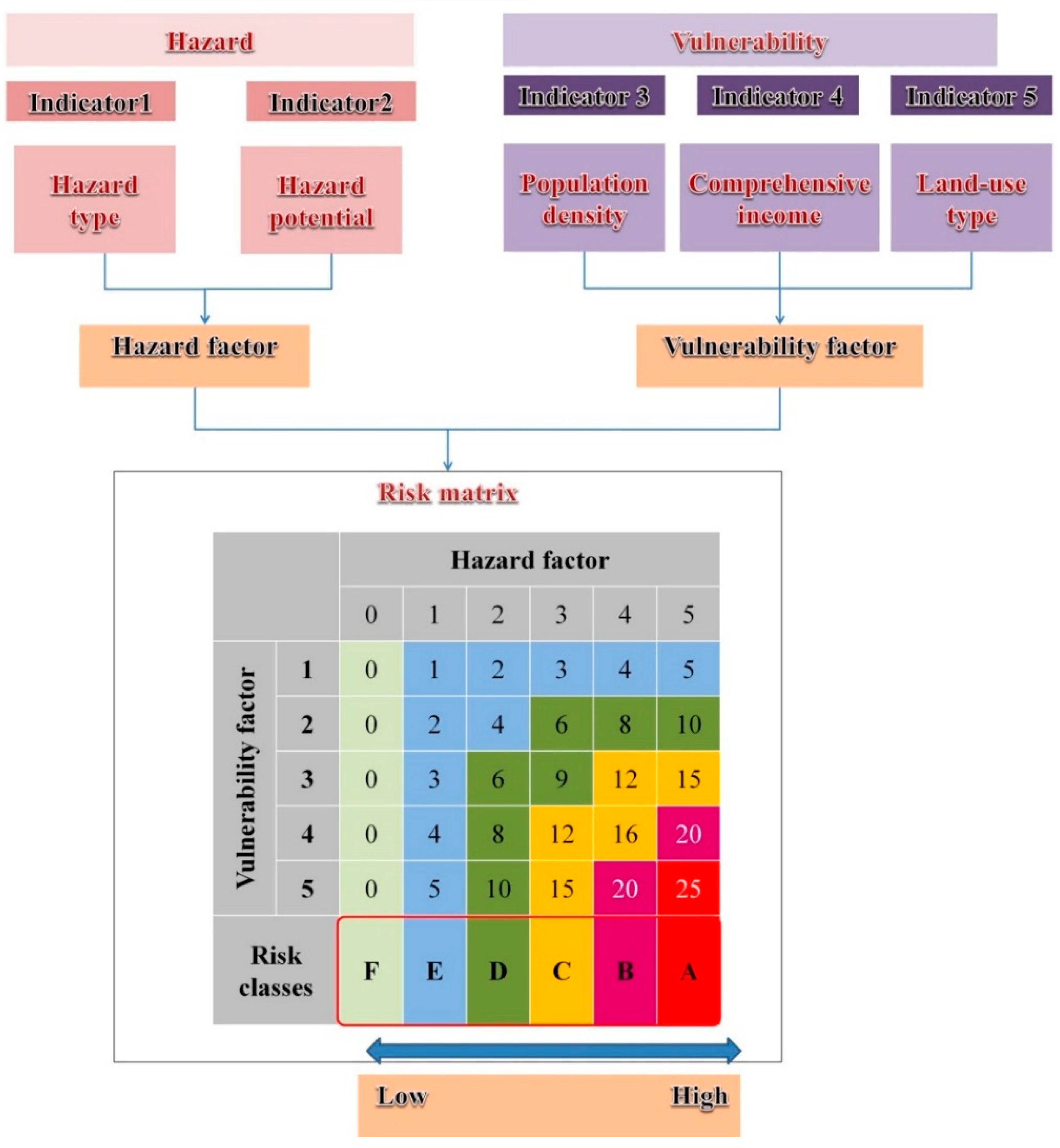
| Coastal Hazard | High Potential | Medium Potential | Zoning Principle | |
|---|---|---|---|---|
| First-Grade | Second-Grade | |||
| Storm surge | Shore land areas with an elevation lower than the level of a 50-year storm surge height, and a flooding depth of 1 m or more | Shore land areas with an elevation lower than the level of a 50-year storm surge height, and a flooding depth of less than 1 m |
| Coastal sectors with one or more medium potential compound hazards. |
| Coastal erosion | Shore land areas identified as susceptible to coastal erosion and its possible effects within 10 years | Shore land areas identified as susceptible to coastal erosion and its possible effects within 10–30 years | ||
| Flood | Shore land areas within the range of a 50-year flood, and with a flooding depth of 1 m or more | Shore land areas within the range of a 50-year flood, and with a flooding depth between 0.5–1 m | ||
| Ground subsidence | Areas that encounter severe ground subsidence, as determined by the Water Resources Agency | - | ||
| Hazard Factor Grading | Cvi Grading | ||||
|---|---|---|---|---|---|
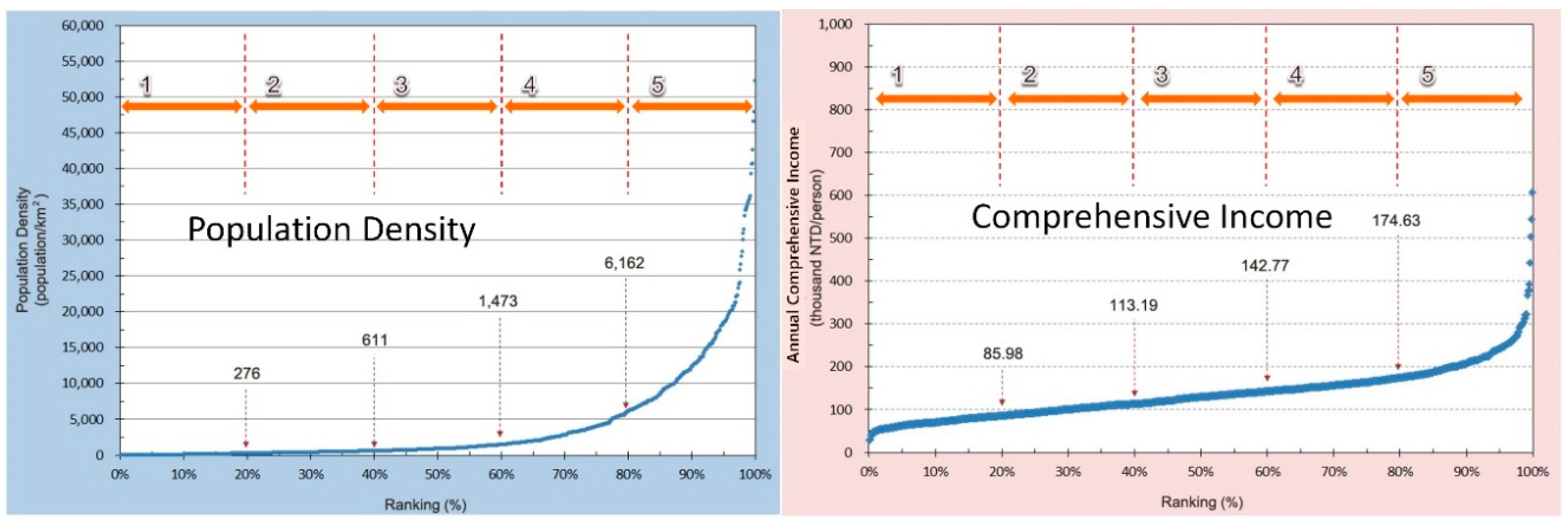
| Score | Hazard Type | Hazard Potential 1 | Population Density | Comprehensive Income | Land Use |
| 5 | 5 types of hazards | 66–100% | 80–100% | 80–100% | Residential, commercial, educational, and medical areas |
| 4 | 4 types of hazards | - | 60–80% | 60–80% | Industry, port activity, and public infrastructure areas |
| 3 | 3 types of hazards | 33–66% | 40–60% | 40–60% | Productive area (agriculture, aquaculture, and livestock breeding) |
| 2 | 2 types of hazards | - | 20–40% | 20–40% | Non-productive areas (mining, salt, sandstone, funerary, artificial lakes and channels) |
| 1 | Single hazard | 0–33% | 0–20% | 0–20% | Natural areas |
| 0 | No hazard | - | - | - | - |
| Risk Levels | Coastal Protection Structural Design Criteria | Protection Design Criteria for Land Use Management | |||||
|---|---|---|---|---|---|---|---|
| Coastal Structural Protection Facilities | Residential Areas or Crucial Social and Economic Areas | Industrial Land | Public Evacuation Facilities | Agriculture, Fishery, and Animal Husbandry | Nonproductive Land | ||
| High | Level A | 100-year return period | ≤25 | - | |||
| High intermediate | Level B | 50–100 year return period. | |||||
| Moderate | Level C | 50-year return period | |||||
| Low intermediate | Level D | 25–50 year return period. | |||||
| Low | Level E | 25-year return period | |||||
| Minimal | Level F | - | |||||
| Considering factor | Wave and storm surge level | Storm surge level and regional flood potential | |||||
| Coastal Administrative Division | Risk Assessment | Suggested Design Criteria (Return Period) | Protection Facility |
|---|---|---|---|
| Mailiao Township: | C, D | 25–50 | Hoanliao seawall |
| Houan Village | |||
| Haifeng Village | |||
| Taixi Township: | C, D | 25–50 | Xinxing Tidal Land seawall Taisi Tidal Land seawall Haikou seawall Haixin seawall |
| Wengang Village | |||
| Hefeng Village | |||
| Wugang Village | |||
| Haikou Village | |||
| Xiding Village | |||
| Sihu Township: | C, D | 25–50 | Lincuoliao seawall Santiaolun seawall Boziliao seawall |
| Lincuo Village | |||
| Lunbei Village | |||
| Guanggou Village | |||
| Bozi Village | |||
| Kouhu Township: | C, D, E | 25–50 | Xialun seawall Yanchoucuo seawall Qinghan seawall Xingang seawall Taizi Village seawall |
| Xialun Village | |||
| Qinghan Village | |||
| Gangxi Village | |||
| Taizi Village |
| Protection Facility | Constructed Year | Design Height (m) | Surveyed Height (m) (2012) | Subsidence Rate (m/year) 3 | Run-Up Height (m) | |
|---|---|---|---|---|---|---|
| 25-Year Return Period | 50-Year Return Period | |||||
| Hoanliao seawall | 2000 | 6.50 | 6.16 | 0.03 | 1 | |
| Taixi tide barrier | 2004 | 5.00 | 4.68 | 0.05 | 2.98 | 3.59 |
| Haikou seawall | 1994 | 6.00 | 4.42 | 0.10 | 2.55 | 2.64 2 |
| Xinxing tide barrier | 1996 | 6.00 | 4.39 | 0.11 | 2.55 | 2.64 2 |
| Lincuoliao sea-wall | 1997 | 6.50 | 5.85 | 0.41 | 2.55 | 2.64 2 |
| Santiaolun seawall | 2010 | 5.50 | 5.41 | 0.04 | 3.25 | 3.70 |
| Boziliao seawall | 1998 | 6.50 | 5.89 | 0.05 | 3.51 | 4.00 |
| Xialun seawall | 2000 | 6.50 | 5.78 | 0.07 | 3.28 | 3.75 |
| Yanchoucuo seawall | 1996 | 6.50 | 5.58 | 0.07 | 2.55 | 2.64 2 |
| Qinghan seawall | 1993 | 5.00 | 4.06 | 0.05 | 2.55 | 2.64 2 |
| Xingang seawall | 1998 | 6.50 | 6.00 | 0.04 | 2.55 | 2.64 2 |
| Taizi Village seawall | 1999 | 6.50 | 5.99 | 0.05 | 3.58 | 4.00 |
© 2018 by the authors. Licensee MDPI, Basel, Switzerland. This article is an open access article distributed under the terms and conditions of the Creative Commons Attribution (CC BY) license (http://creativecommons.org/licenses/by/4.0/).
Share and Cite
Huang, W.-P.; Hsu, J.-C.; Chen, C.-S.; Ye, C.-J. The Study of the Coastal Management Criteria Based on Risk Assessmeant: A Case Study on Yunlin Coast, Taiwan. Water 2018, 10, 988. https://doi.org/10.3390/w10080988
Huang W-P, Hsu J-C, Chen C-S, Ye C-J. The Study of the Coastal Management Criteria Based on Risk Assessmeant: A Case Study on Yunlin Coast, Taiwan. Water. 2018; 10(8):988. https://doi.org/10.3390/w10080988
Chicago/Turabian StyleHuang, Wei-Po, Jui-Chan Hsu, Chun-Shen Chen, and Chun-Jhen Ye. 2018. "The Study of the Coastal Management Criteria Based on Risk Assessmeant: A Case Study on Yunlin Coast, Taiwan" Water 10, no. 8: 988. https://doi.org/10.3390/w10080988
APA StyleHuang, W.-P., Hsu, J.-C., Chen, C.-S., & Ye, C.-J. (2018). The Study of the Coastal Management Criteria Based on Risk Assessmeant: A Case Study on Yunlin Coast, Taiwan. Water, 10(8), 988. https://doi.org/10.3390/w10080988